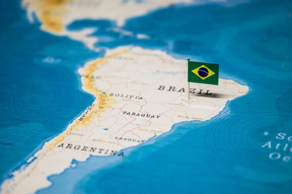
Brazil is located in the South America region at latitude -14.235004 and longitude -51.92528 and is part of the South American continent.
The DMS coordinates for the center of the country are:
- 14° 14' 6.01'' S
- 51° 55' 31.01'' W
You can see the location of Brazil on the world map below:
Brazil Neighboring Countries
The neighboring countries of Brazil (BR) are:
- Argentina (AR)
- Bolivia (Plurinational State Of) (BO)
- Colombia (CO)
- French Guiana (GF)
- Guyana (GY)
- Paraguay (PY)
- Peru (PE)
- Suriname (SR)
- Uruguay (UY)
- Venezuela (Bolivarian Republic of) (VE)
The country has no neighboring countries/land borders.
Maritime Borders
Brazil borders the Atlantic Ocean.
Brazil Related Content
- Brazil States Map
- Brazil Regions Map
- What is the Capital of Brazil?
- Brazil Flag Map and Meaning
- Tourism in Brazil: 20 Reasons to Visit
Brazil Key Facts
| Country | Brazil |
| Coordinates | Latitude: -14.235004 Longitude: -51.92528 |
| Country Codes | Alpha 2: BR Alpha 3: BRA |
| Country Flag Emoji | 🇧🇷 |
| Int. Phone Prefix | +55 |
| Capital city | Brasilia |
| Continent Subcontinent | South America South America |
| Country Area | 8,515,770 sq km |
| Population 2024 | 211,998,573 World Rank: 7 |
| Median Age | 32.8 |
| Life expectancy | 75.8 |
| Major languages | Portuguese (official and most widely spoken language) |
| UTC/GMT Time | Number of time zones: 4
|
| Internet TLD | .br |
| Biggest Airport | Guarulhos International Airport São Paulo (GRU) |
| Average temperature | 24.95 °C 76.91 °F |
| Administrative Divisions | 1 federal district 26 states |
| Political system | Federal presidential representative democratic republic |
Brazil Economy Facts
| World Bank Income Group | Upper middle income |
| World Bank Region | Latin America & Caribbean |
| Currency | Brazilian Real (BRL) |
| GDP in 2024 | $2185.8 (billions of USD) World Rank: 10 |
| GDP per capita in 2024 | $10,311 World Rank: 101 |
| Major Industries / Economic Sectors | Agriculture, mining, manufacturing, energy, services |
| Top 5 Import Countries | China, United States, Argentina, Germany, Netherlands |
| Top 5 Export Countries | China, United States, Argentina, Netherlands, Belgium |
Biggest Cities in Brazil
Here are the largest cities in Brazil based on 2024 data:
| City | Population |
|---|
| Sao Paulo | 12,400,232 | Rio de Janeiro | 6,747,815 | Belo Horizonte | 2,721,564 | Salvador | 2,711,840 | Fortaleza | 2,400,000 | Manaus | 2,219,580 | Brasilia | 2,207,718 | Curitiba | 1,948,626 | Recife | 1,653,461 | Goiania | 1,536,097 |
Map of Brazil with the Largest Cities
Other Countries in the South America Region
Brazil Location Map
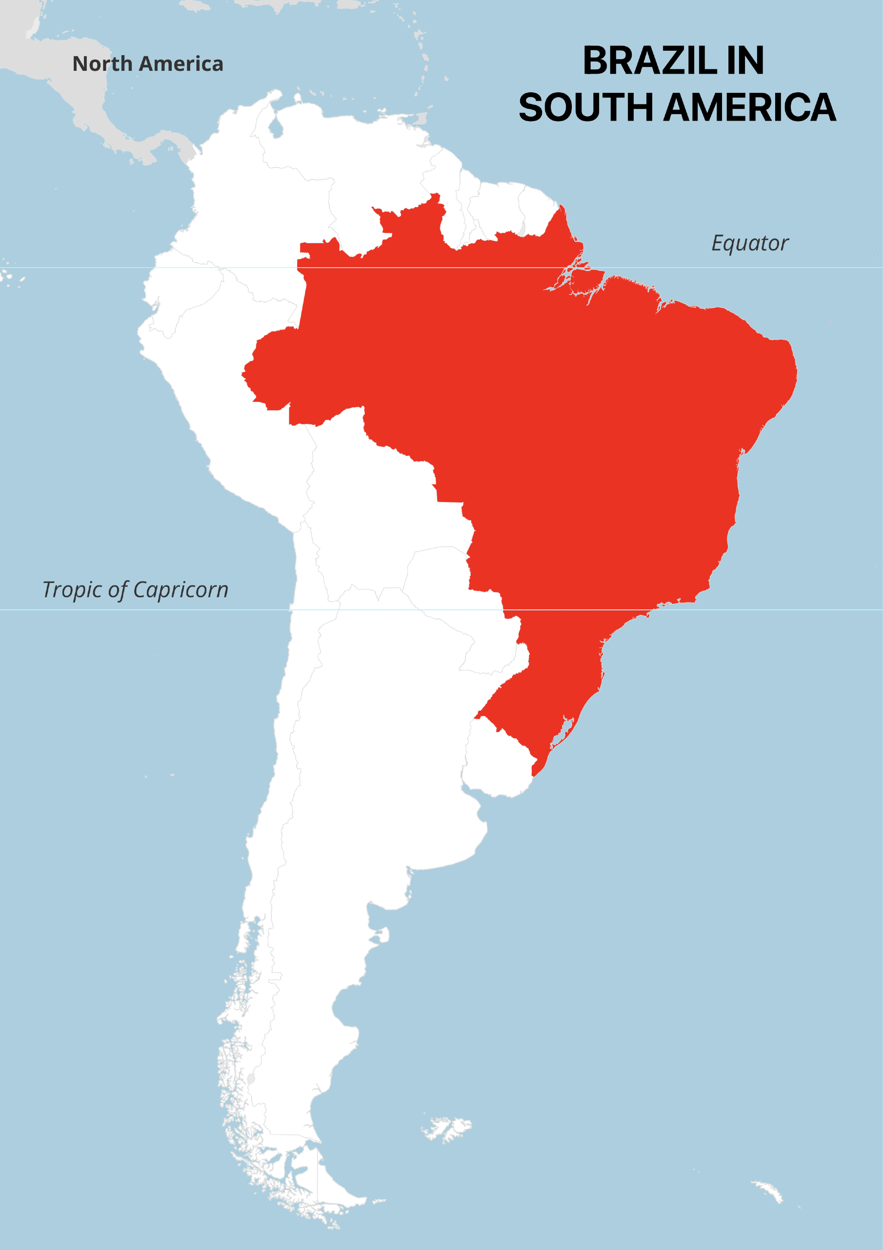
The Brazil Location Map in South America is a simple map that highlights the location of Brazil within the continent of South America. In addition to showing the shape and boundaries of Brazil, the map also includes two important geographic reference lines: the equator line and the Tropic of Capricorn line.
These lines provide additional context to the viewer by indicating key latitudinal reference points on the globe. The equator line represents the imaginary line around the Earth’s middle that is equidistant from the North and South Poles, while the Tropic of Capricorn line represents the southernmost latitude where the sun can be directly overhead.
The Brazil Location Map is an effective tool for quickly and easily identifying the location of Brazil within South America, while also providing some basic geographic context.
Bossa Nova, Copacabana, Christ the Redeemer, Caipirinhas, Pele, and the Amazon. There are plenty of reasons Brazil is famous around the world, and its cultural reach is rivaled by its physical size. A political map of Brazil and its neighboring countries is probably the best way to grasp the country’s impressive size and where its huge population lives.
Political Maps of Brazil
Brazil covers 8.5 million square kilometers (3.3 million square miles) of land, which makes it the fifth largest country in the world and fairly easy to spot on a world map.
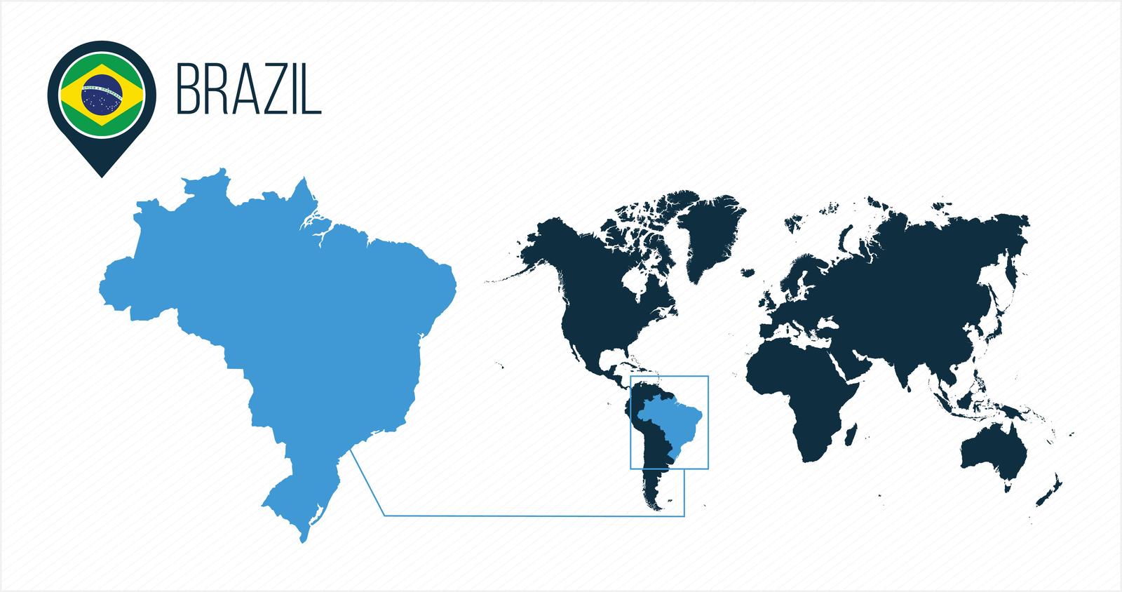
In the above world map, Brazil is highlighted in blue. This visualization highlights just how large the country is and how much of South America it occupies. The green, yellow, and blue image on the map represents the flag of Brazil.
Region and Bordering Countries
Brazil is located in the region of Latin America, which includes countries from South America, Central America, and Mexico. The region is loosely defined as countries in the Americas where Romance languages (e.g. Spanish, Portugues, French) are spoken, though there is no precise definition.

The above political map clearly shows just how large Brazil is compared to its Latin American neighbors. It borders almost every other country in South America, and it is the only country in the Americas to have Portuguese as an official language. It’s also the largest country in the world that uses Portuguese as an official language.
Brazil Cities and Rivers Map
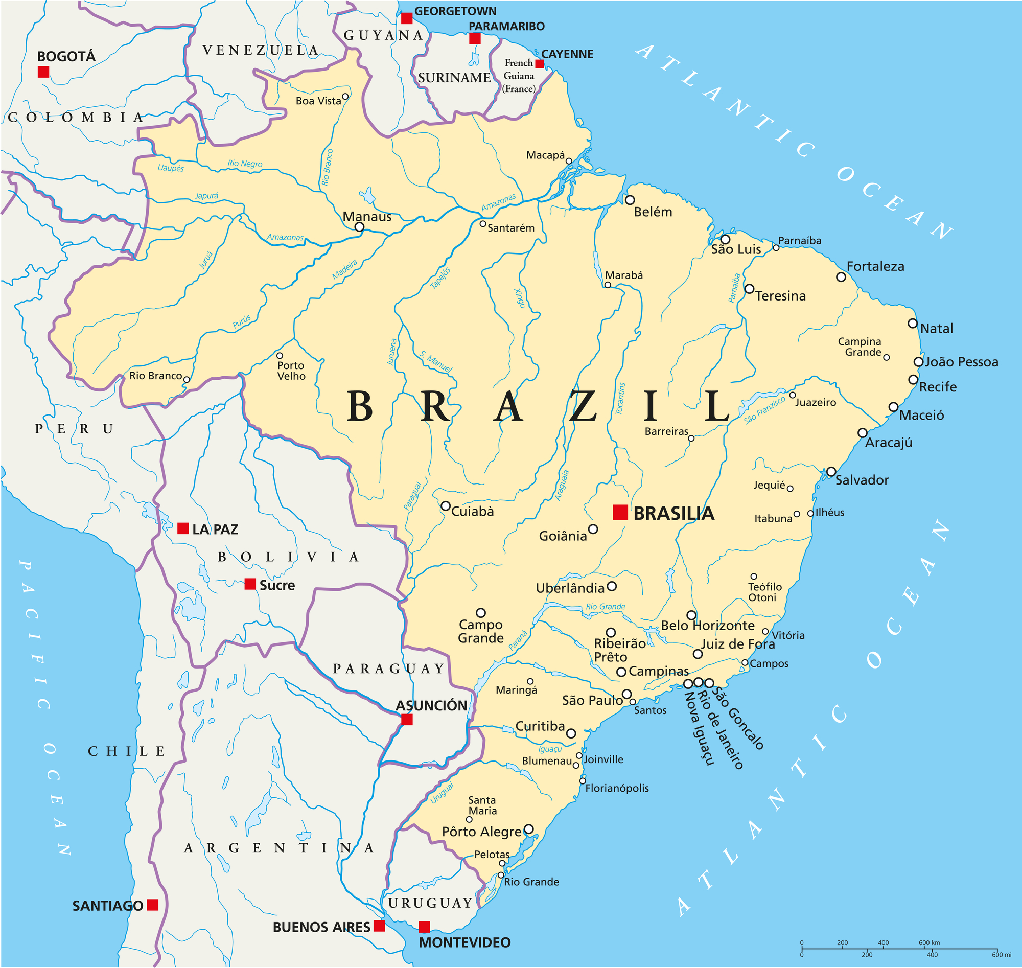
The above political map shows in detail the major rivers that make up Brazil’s complex river system. The Amazon River can be seen flowing into the Atlantic Ocean on Brazil’s northeastern coast near Macapá.
Also see: South America River Map
The map also illustrates the locations of Brazil’s important cities and towns. The capital is marked with bold lettering and a red square in the south-central region of the country. It’s possible to note that most of the major cities in Brazil, with exception of the capital and a few others, lie along the country’s coast. This is where the majority of the population lives.
Brazil Regions and States
The 5 Regions of Brazil
There are five major regions of Brazil, which are purely geographical as opposed to political or administrative. The regions are used for statistical purposes and each has its own unique geographical features.
- North
- Center-West
- Northeast
- Southeast
- South

The largest administrative divisions in the country are the 26 Brazilian states and one federal district. These states are further divided into 5,570 municipalities, and Brasília is the capital of Brazil.
Major Cities of Brazil
São Paulo

São Paulo has the largest population of any city proper in the Americas, the Western Hemisphere, or the Southern Hemisphere. It’s also the fourth most populous city proper in the world.
The city is the capital of the Brazilian state of the same name, and they are both economically powerful. The state is the most populous and wealthiest in the country, and the city has the largest GDP of any in Latin America and the Southern Hemisphere.
In addition to economic importance, São Paulo has a significant cultural and political influence both within the country and internationally. The city is full of important landmarks like some of the tallest skyscrapers in Brazil along with monuments, parks, and museums.
The population of São Paulo is one of the most diverse of any city on the planet. Residents represent more than 200 different nationalities. Other things this city is known for are its unpredictable weather, impressive architecture, and intense traffic. The city is named after the Christian apostle Saint Paul.
Rio de Janeiro

This is one of the most internationally famous cities in Brazil. The image that many associate most with Brazil is of the Christ the Redeemer statue that sits on top of Corcovado Mountain. There are also world-famous beaches like Ipanema and Copacabana located in Rio de Janeiro, and these are some of the reasons it’s the most visited city in the southern hemisphere.
Rio de Janeiro is the second most populous city in Brazil, and it served as a capital city until Brasília was made the capital in 1960. It is still the capital of the Brazilian state of the same name, which translates to “River of January” in English.
The city is also famous for its connection to the world of sports. It was the host of the 2016 Summer Olympics and the 2016 Summer Paralympics. It also has one of the largest football stadiums in the world, Maracanã Stadium, which has hosted two FIFA World Cups, a FIFA Confederations Cup, and the XV Pan American Games.
This city has something of a reputation for being a dangerous city with a high crime rate. While visitors should certainly remain vigilant in the city and petty theft is a fairly common occurrence, the city is far from having the highest crime rate in the country.
Brasília
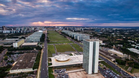
Brasília is the third most populous city in Brazil and has been the national capital since 1960. It is a planned city that was created with the express purpose of becoming the nation’s capital. As such, it is notable as an example of creative urban planning and has been inscribed as a UNESCO World Heritage Site.
The capital city is located in the Brazilian Highlands, just west of the country’s center. Brasília occupies its own federal district rather than a state. A notable geographical feature is Paranoá Lake, a large artificial lake that was constructed in order to increase the city’s access to water and to maintain humidity in the region.
As the country’s capital, the economy of Brasília is different from the industrially focused cities in the country. Instead of production, its major economic industries are construction and services related to government, finance, communications, law, and entertainment.
Salvador
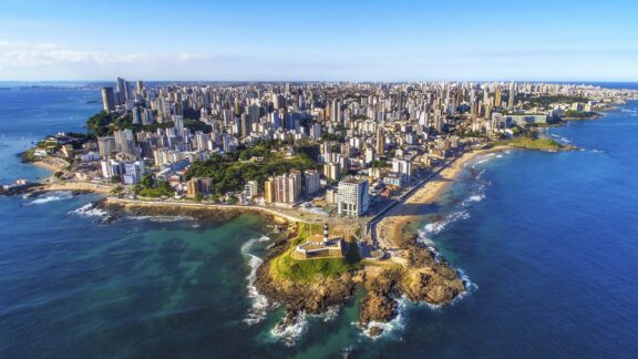
This city is also known by its significantly longer name, São Salvador da Bahia de Todos os Santos, which means “Holy Savior of the Bay of All Saints” in English. Salvador is Brazil’s fourth most populous city and is located on the Atlantic Coast in the state of Bahia.
Salvador was the first capital city of Colonial Brazil, and its founding during the Rennaisance Period makes it one of the oldest cities in the Americas. It is also one of the first planned cities in the world.
Today, Salvador is known for being a center of Afro-Brazilian culture as well as for its cuisine, architecture, colonial heritage, and sunny climate. It is important as a port city and has one of the highest GDPs of any city in the region.
The city has also hosted several major international sporting, political, and cultural events and is home to several universities and headquarters of international organizations.
Fortaleza
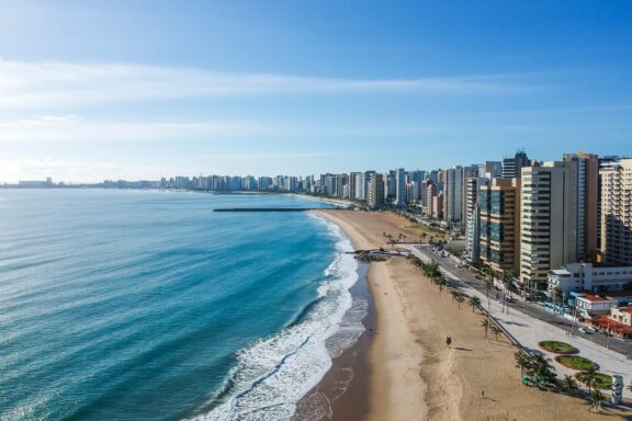
Fortaleza is a city located in northeastern Brazil with a population of 2.7 million, making it the fifth most populous city in the country. It is the capital of the state of Ceará and the closest Brazilian capital to the European continent.
Cocó Park is found in Fortaleza, which is one of the largest urban parks in Latin America and an important green area in the city. It lies along the Cocó River, where mangroves and a wide variety of plants and animals reside. The park is used for education and guided tours with ecological trails and events.
Culturally, Fortaleza is known for being home to a number of famous comedians and for being the birthplace of forró music and dance. The nightlife in this city is also particularly vibrant, and it is one of the most popular locations for domestic tourists to visit.
Geography
The geography of Brazil is incredibly diverse, and this is largely due to the country’s considerable size. It stretches across a massive portion of South America, covering much of the continent’s interior as well as 7,491 kilometers (4,655 miles) of coastline on the Atlantic Ocean. It includes four timezones, a number of archipelagos, and is the longest country in the world from north to south.
One of the most notable features of Brazil’s landscape is the Amazon Rainforest. It is the largest and most biodiverse rainforest on Earth, and 60% of it exists within the Brazilian territory. Primarily because of the rainforest, Brazil has the highest biodiversity of any country on the planet, and it is second only to Indonesia in terms of endemic species.
Brazil’s physical geography also consists of hills, valleys, an immensely complex river system (including the Amazon River), savannahs, and mountain ranges. Serra dos Órgãos National Park is an especially striking national park with ten peaks over 2,000 meters (6,600 ft).
Economy
With a wealth of natural resources, Brazil has the largest national economy in Latin America. The activities that support its economy are diversified, and its exports an exceptionally wide range of goods. It is one of the world’s largest exporters of animal proteins — a leader in chicken, beef, milk, pork, and eggs — and is the second highest exporter of iron ore in the world.
Trade and services also make up a large portion of the country’s GDP. These sectors include activities related to commerce, accommodation, transport, communication, financial services, real estate, and more. Corruption is known to cost the country billions of dollars each year and is considered by many in the country to be a major factor preventing Brazil from penetrating the global market.
Demographics and Culture
Brazil has an estimated 2022 population of 215,324,733, which makes it the seventh most populous in the world. This population is heavily concentrated along the coast in the northeastern and southeastern regions of the country. The Center-West and North regions, which account for most of the country’s territory, are much more sparsely populated.
Racial diversity is high in Brazil due to high levels of immigration from many different countries and the genetic mixing of Amerindians, Africans, and Europeans. About 65% of the population in Brazil has European ancestry of some kind. There is a high level of income disparity between racial groups. Brazil is also home to the highest number of indigenous peoples in voluntary isolation.
The official language of Brazil is Portuguese, and it is spoken by the majority of people in the country. There are also 180 Amerindian minority languages spoken throughout the country. Brazilian Portuguese differs slightly from what is spoken in Portugal, mostly with regard to pronunciation, though there are some vocabulary differences as well.
Brazil FAQs
What countries border Brazil?
Brazil shares land borders with ten countries: French Guiana (a department of France), Suriname, Guyana, Venezuela, Colombia, Peru, Bolivia, Paraguay, Argentina, and Paraguay. This means Brazil borders every South American country except for Ecuador and Chile.
Is Brazil safe?
The safety of Brazil varies greatly by region. This makes it important for visitors to acquaint themselves with local advice and specific information regarding the area they visit. The US Department of State posts a travel advisory for Brazil and specific regions in the country.
It isn’t recommended to travel near Brazil’s international borders or to favelas.
What is Brazil famous for?
Brazil is known for its football legends, amazing beaches, music, the Amazon River and Rainforest, and diverse cities. The Christ the Redeemer statue in Rio de Janeiro is an iconic image of Brazil.
Is English widely spoken in Brazil?
No, English is not widely spoken in Brazil. The official national language in the country is Portuguese, and it is spoken by the vast majority of the population. There are also some minority languages spoken in the country, and people working in the international tourism sector are more likely to speak English.
What’s the average salary in Brazil?
The average yearly salary in Brazil is equivalent to roughly $55,348 USD, though a more typical salary is lower due to high levels of income disparity and is closer to $32,008 USD.


- Brazil in south america map — © Mappr
- Aerial View of São Paulo Skyline — © ADVTP/Shutterstock
- Misty Sunrise Over Rio de Janeiro Skyline — © lazyllama/Shutterstock
- Map of South America Highlighting Brazil with Flag Pin — © hyotographics/Shutterstock