Brazil is a massive country, and as such, it contains a high diversity of landscapes, cultures, economies, and people. Looking at maps of Brazil is helpful for getting an idea of its considerable size, and looking at the individual regions that make up the country is a great way to reach a better understanding of the diversity that exists in the country.
In this post, we’ll look at a map of Brazil’s five regions and explore what makes each of them unique.

The 5 Regions of Brazil
Brazil is divided into five regions. These are based on geographical, economic, and social distinctions and don’t have political or administrative significance, but they are used for surveys and statistical purposes such as seeing how resources are allocated throughout the country.
North
Accounting for more than 45% of Brazil’s total land area, this is the largest region in the country, but it’s also the second least populated. The estimated population in 2021 was 18.91 million, which gives the state the lowest demographic density of any in the country.
The seven states that lie within this region are Acre, Amapá, Amazonas, Pará, Rondônia, Roraima and Tocantins. Amazonas is the largest state in the region and Manaus is the most populous city with more than 2.2 million people.
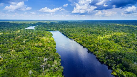
The geography of this region is notable for containing a large portion of the Amazon rainforest. Not only is the Amazon the largest rainforest in the world, it has an incredibly high level of biodiversity. More than 1/3 of all species on the planet live in the Amazon Rainforest. This includes millions of insect species, at least 40,000 plant species, and thousands of fish and birds. The Amazon River system is the longest river in South America.
Most of the North Region of Brazil has a rainforest or monsoon climate, and the area closer to the coast has a savanna climate.
The North region has its own culture and traditions, and some popular cultural festivals are held here. One of these is the Parintins Folklore Festival, which takes place in the city of Parintins and celebrates a local legend about a resurrected ox. It’s one of the largest festivals in all of Brazil, only surpassed by the Carnival festivals in Rio de Janeiro and Salvador in attendance.
Center-West
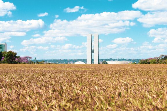
The Center-West Region of Brazil is the least populated region in the country, with a 2021 population of roughly 16.71 million. It covers 18.86% of the country’s territory and borders every other region in the country. It is the only region of Brazil that doesn’t have a coastline on the Atlantic Ocean.
This region contains the states of Goiás, Mato Grosso and Mato Grosso do Sul. It’s also the home of Brazil’s federal district, which is where Brasília, the capital of Brazil, is located. Thanks to the relocation of the country’s capital from Rio de Janeiro to Brasília, the transportation infrastructure leading into the Center-West Region has been greatly improved.
The geography of Brazil’s Center-West Region is very diverse and includes Amazonian forest, savanna, sand banks, fields, wetlands, caves, plateaus, valleys, and more. Chapada dos Guimarães National Park is a significant tourist attraction in the state of Mato Grosso that’s full of cliffs and waterfalls. This is also where the geographic center of the continent is located.
Also located in Mato Grosso is Pantanal, a geographical area that includes the world’s largest tropical wetland. There are nearly one thousand species that live in this wetland, and it extends into neighboring Bolivia and Paraguay.
Northeast
There are approximately 57.67 million people living in Brazil’s Northeast Region, which makes it the second most populated state in the country. There are nine states within this region: Maranhão, Piauí, Ceará, Rio Grande do Norte, Paraíba, Pernambuco, Alagoas, Sergipe and Bahia.
The region covers about 18% of Brazil’s total territory, stretching from the Atlantic coast to the Amazon Basin in the west. This area covers four geo-climatic subregions, all of which regularly experience high temperatures.
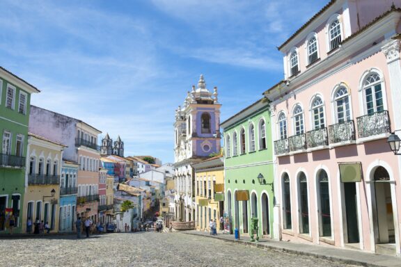
Hot weather, history, and culture are what the region is known for. The history here differs from elsewhere in the country because it was the first area reached by Portuguese and other European colonizers. Recife, Olinda, and Salvador are colonial cities that receive high numbers of tourists.
Recife and Olinda are both cities in the state of Pernambuco, Recife is the capital and largest in the state. Recife gets its name from the stone reefs that line the city’s shore, and the city’s many bridges have earned it the nickname, “Brazilian Venice.”
Salvador is special to Brazilian history because it was the nation’s first capital. It’s also one of the world’s first planned cities and was founded during the Renaissance Period. The cultural and musical traditions in Salvador are of special importance in Brazil.
The region’s folklore, cuisine, music, and literature are easily distinguishable from other regions. Frevo, Xote, and Xaxado are some of the popular music genres that are said to have originated in the region, and sarapatel, sururu, and carne de sol are some of its traditional dishes.
Most of this region’s population, almost 75%, live near the coastline. The rest of the population is spread out through the region’s interior. There is a high level of poverty in the region: about 35% of people live on the equivalent of $2 USD per day or less.
Southeast
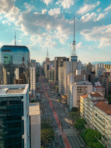
Containing the cities of São Paulo and Rio de Janeiro, the Southeast Region in Brazil is the most populated by a long shot. There were an estimated 89.63 million people living here in 2021. It is the wealthiest region in the country, accounting for around 60% of the national GDP, and it also leads the country in population density, industries, universities, airports, and much more.
Tourism in Brazil is most prominent in the Southeast Region. Rio de Janeiro is visited frequently for being known as one of the most iconic and beautiful cities in the country, as is Sao São Paulo for being the largest city as well as a financial and gastronomical center. The state of Minas Gerais has the highest concentration of historical cities in the country.
In terms of geography, the Southeast is dominated by the Brazilian Highlands. These continue from the interior of the country to the coast, where they turn into steep slopes. The coastline in the northern portion of the region includes some of the most beautiful beaches in the world.
The rapid economic growth in cities like São Paulo has led to dramatic population increases that have led to increased pollution and insufficient housing options. There are large areas on the outskirts of the larger cities in this region where people live in poor-quality housing.
South
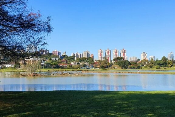
The South is the smallest region in Brazil and includes just three states: Paraná, Rio Grande do Sul, and Santa Catarina. It has the third-smallest population of Brazil’s regions and it also has the lowest crime rate, making it one of the safest places in the country.
All areas of Brazil’s South Region were already inhabited by the time Portuguese and Spanish colonizers arrived. The two nations competed over control of territory, meanwhile converting native peoples to Catholicism.
German settlers also arrived in the area, and immigrants of many more nationalities arrived during the 19th century.
Due to high levels of immigration, the culture of this region has been greatly impacted by European influence. There are especially high numbers of people with ancestry that is Portuguese, Italian, German, Austrian, Luxembourger, Polish, Ukrainian, and Spanish, among others.
The region currently has a high level of urbanization and standard of living. It has the highest Human Development Index score of any region and the second-highest income per capita.


