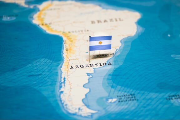
Argentina is located in the South America region at latitude -38.416097 and longitude -63.616672 and is part of the South American continent.
The DMS coordinates for the center of the country are:
- 38° 24' 57.95'' S
- 63° 37' 0.02'' W
You can see the location of Argentina on the world map below:

Argentina Neighboring Countries
The neighboring countries of Argentina (AR) are:
- Bolivia (Plurinational State Of) (BO)
- Brazil (BR)
- Chile (CL)
- Paraguay (PY)
- Uruguay (UY)
Maritime Borders
Argentina borders the Atlantic Ocean.
Argentina Related Content
Argentina Key Facts
| Country | Argentina |
| Coordinates | Latitude: -38.416097 Longitude: -63.616672 |
| Country Codes | Alpha 2: AR Alpha 3: ARG |
| Country Flag Emoji | 🇦🇷 |
| Int. Phone Prefix | +54 |
| Capital city | Buenos Aires |
| Continent Subcontinent | South America South America |
| Country Area | 2,780,400 sq km |
| Population 2021 | 45,808,747 World Rank: 32 |
| Median Age | 31.3 |
| Life expectancy | 75.4 |
| Major languages | Spanish (official), Italian, English, German, French, indigenous (Mapudungun, Quechua) |
| UTC/GMT Time | Number of time zones: 1
|
| Internet TLD | .ar |
| Biggest Airport | Ministro Pistarini International Airport (EZE) |
| Average temperature | 14.80 °C 58.64 °F |
| Administrative Divisions | 1 city 23 provinces |
| Political system | Federal presidential representative democratic republic |
Argentina Economy Facts
| World Bank Income Group | Upper middle income |
| World Bank Region | Latin America & Caribbean |
| Currency | Argentine Peso (ARS) |
| GDP in 2020 | $389.6 (billions of USD) World Rank: 29 |
| GDP per capita in 2020 | $8,586 World Rank: 73 |
| Major Industries / Economic Sectors | Agriculture, manufacturing, energy, tourism |
| Top 5 Import Countries | Brazil, China, United States, Chile, Paraguay |
| Top 5 Export Countries | Brazil, China, United States, Chile, Netherlands |
Biggest Cities in Argentina
Here are the largest cities in Argentina based on 2021 data:
| City | Population |
|---|
| Buenos Aires | 16,216,000 | Cordoba | 1,329,604 | Rosario | 1,193,605 | Comodoro Rivadavia | 730,266 | San Miguel de Tucuman | 605,767 | Mar del Plata | 593,337 | Salta | 535,303 | San Juan | 471,389 | Lanus | 459,263 | Florencio Varela | 426,005 |
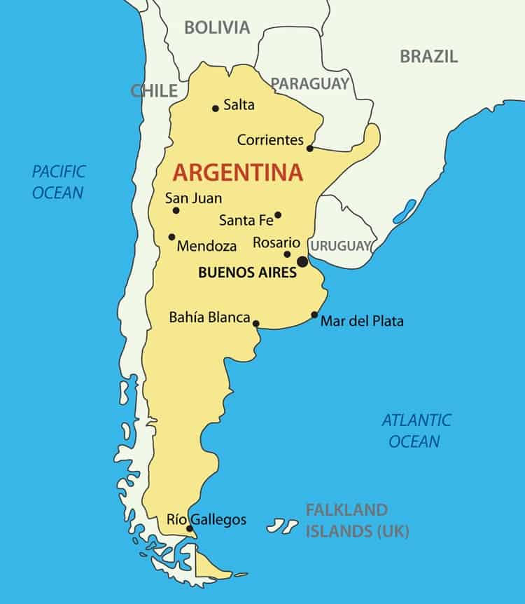
Map of Argentina with the Largest Cities
Other Countries in the South America Region
Nestled between Chile to the west and Uruguay to the east, Argentina occupies much of the Southern Cone of South America.
Map of Argentina (Political)

Argentina’s neighboring countries are Chile, Bolivia, Paraguay, Brazil, and Uruguay. Argentina has a long coastline facing the Atlantic Ocean.
The map of Argentina above shows the locations of nine major cities, including:
- Buenos Aires
- Córdoba
- La Plata
- Mar del Plata
- San Miguel de Tucumán
- Salta
- Santa Fe de la Vera Cruz
- Vicente López
- Corrientes
The capital city of Argentina is Buenos Aires.
The population of Argentina in 2021 is around 45.8 million.
Argentina is a Federal Republic with two legislative houses.
With a total area of 2,780,400 km2, it is the biggest Spanish-speaking country, the second-largest country in South America, and the eighth-largest country globally.
The official language is Spanish, but the country also recognizes several regional languages:
- Guarani
- Quechua
- Qom
- Mokovi
- Wichi
- Welsh
Argentina is still considered a developing nation with an emerging market, despite having the second-largest economy in South America, after Brazil.
It produces the most grain of all Latin American nations, comes second in cattle raising, after Brazil, and second in tourism, after Mexico.
The Argentinian people boast a 99% literacy rate and have access to free higher education through public schools.
Argentina is currently home to eleven UNESCO World Heritage sites:
- Cueva de las Manos, Río Pinturas
- Jesuit Block and Estancias of Cordoba
- Jesuit Missions of the Guarani
- Qhapaq Nan Andean Road System
- Quebrada de Humahuaca
- Architectural works of Le Corbusier
- Iguazu National Park
- Talampaya Natural Parks
- Los Alerces National Park
- Los Glaciares National Park
- Peninsula Valdes
There are an additional ten properties on the tentative list. The most recent addition, made in 2019, is the Sanmatinian Routes.
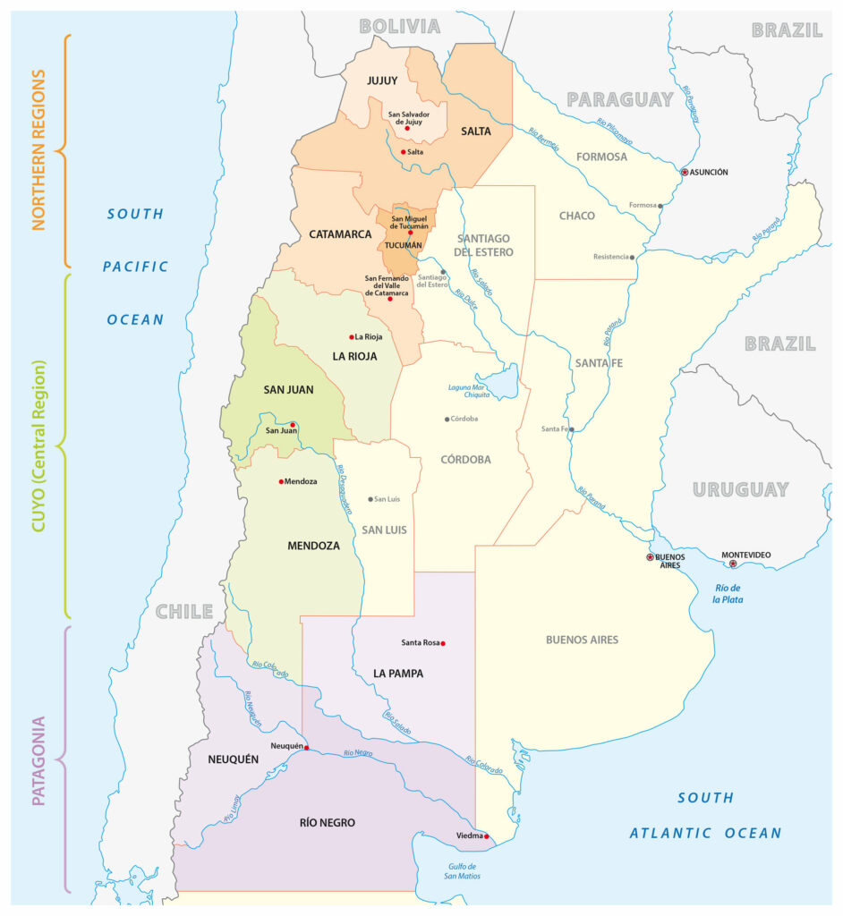
Regions of Argentina Map

As the above Argentina political map shows, the country can be grouped into three key regional zones: the Northern Regions, the Cuyo, or Central Regions, and Patagonia.
The Andes cut through all three down the western border that separates Argentina and Chile.
Northern Regions
The Northern Regions of Argentina consist of three main divisions.
Northwest
The provinces of Catamarca, Jujuy, La Rioja, Salta, Santiago del Estero, and Tucuman form the Argentine Northwest region.
Due to extreme changes in elevation across the region, the climate ranges from cold and dry to warm and wet. Due to these conditions, residents of the region mainly settle along the fertile river valleys.
Gran Chaco
The Chaco, Córdoba, Formosa, Salta, Santa Fe, Santiago del Estero, and Tucuman provinces are all part of the Gran Chaco region.
This area is largely subtropical, with many lush forests, savannahs, and marshes. It covers 725,000 km2, spanning parts of Bolivia and Paraguay.
Mesopotamia
The provinces of Misiones, Entre Rios, and Corrientes makeup the Mesopotamia region of Argentina.
These areas of Argentina are hot and humid, with abundant rainfall reaching up to 2,032 mm per year in the province of Misiones.
It is also home to the Iguazu Falls and Ibera Wetlands, two of South America’s most popular tourist attractions
Cuyo (Central Regions)
The Central Regions of Argentina include:
Cuyo
The extremely mountainous Cuyo region comprises San Juan, San Luis, Mendoza, and La Rioja. The highest mountain of the Andes, Aconcagua, is in Cuyo.
The mountains put Cuyo in a rainshadow, creating the ideal low humidity conditions for vineyards to thrive. Winemaking accounts for more than 80% of Argentina’s national production.
La Pampas
La Pampas is a massive 1,200,000 km2 region that includes Buenos Aires, La Pampa, Santa Fe, Entre Rios, and Cordoba.
The flat plains land and well-dispersed rainfall have created ideal conditions for both crops and cattle to thrive, which is why much of the 42,000,000 population works in agriculture or husbandry.
Patagonia
The southern tip of South America is the Patagonia region, which includes Tierra del Fuego, an archipelago in the Southern Atlantic Ocean.
The provinces of La Pampa, Neuquen, Rio Negro, Chubut, and Santa Cruz are in the Patagonian region.
Patagonia is a thriving tourist destination, especially for backpackers. The Perito Moreno Glacier, located in Santa Cruz, is part of the world’s third-largest freshwater supply.
Connections with Antarctica
The Argentine Antarctic Institute, founded in 1951, establishes Argentinian bases in Antarctica, where scientists from the South American nation study a range of fields, including biology, chemistry, and oceanography.
Currently, Argentina claims rights to a majority of the Antarctic Peninsula, from 25° W to 74° W, then back to 60° S, at the South Pole.
They have a total of 13 bases, seven of which are closed during the winter and six available for year-round staffing.
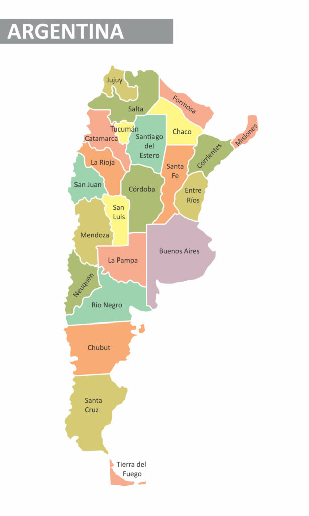
Provinces of Argentina

This Argentina map shows the borders between the 24 provinces.
Each of Argentina’s provinces has its own constitution, but the nation as a whole is a federal system with overarching laws that override individual province laws.
The provinces also host their own justice system, police force, and congress. Apart from the Autonomous City of Buenos Aires, which is split into partidos and localidades, the provinces are divided further into departments and municipalities.
Autonomous City of Buenos Aires
Located on the southeastern coast of Argentina, Buenos Aires is the capital and largest city, with an estimated population of 17,196,396.
It is the most-visited city in South America.
Buenos Aires
Buenos Aires province is separate from the Autonomous City of Buenos Aires.
The capital is La Plata.
It is the largest and most populous province, at 307,571 km2, with a population of 15,625,084.
Catamarca
Catamarca is a northwestern province with an area of 102,602 km2 and a population of 367,828.
The capital city is San Fernando del Valle de Catamarca.
Chaco
Chaco is a northeastern province with an area of 99,633 km2 and a population of 1,055,259.
The capital city is Resistencia.
Chubut
Chubut is a southern province with an area of 224,686 km2 and a population of 509,108.
The capital city is Rawson.
Cordoba
Cordoba is a central province with an area of 165,321 km2 and a population of 3,308,876.
The capital city is Cordoba.
Corrientes
Corrientes is a northeastern province with an area of 88,199 km2 and a population of 992,595.
The capital city is Corrientes.
Entre Rios
Entre Rios is a northeastern province with an area of 99,633 km2 and a population of 1,055,259.
The capital city is Paraná.
Formosa
Formosa is a northeastern province with an area of 72,066 km2 and a population of 530,162.
The capital city is Formosa.
Jujuy
Jujuy is a northwestern province with an area of 52,219 km2 and a population of 673,307.
The capital city is San Salvador de Jujuy.
La Pampa
La Pampa is a central province with an area of 143,440 km2 and a population of 535,184.
The capital city is Santa Rosa.
La Rioja
La Rioja is a province with an area of 89,680 km2 and a population of 333,642.
The capital city is La Rioja.
Mendoza
Mendoza is a western-central province with an area of 148,827 km2 and a population of 1,738,929.
The capital city is Mendoza.
Misiones
Misiones is a northeastern province with an area of 29,801 km2 and a population of 1,101,593.
The capital city is Posadas.
Neuquen
Neuquen is a western province with an area of 94,078 km2 and a population of 551,226.
The capital city is Neuquen.
Rio Negro
Rio Negro is a central province with an area of 203,013 km2 and a population of 638,645.
The capital city is Viedma.
Salta
Salta is a northwest province with an area of 155,488 km2 and a population of 1,214,441.
The capital city is Salta.
San Juan
San Juan is a western province with an area of 89,651 km2 and a population of 681,055.
The capital city is San Juan.
San Luis
San Luis is a northeastern province with an area of 76,748 km2 and a population of 432,310.
The capital city is San Luis.
Santa Cruz
Santa Cruz is a northern province with an area of 243,964 km2 and a population of 273,964.
The capital city is Rio Gallegos.
Santa Fe
Santa Fe is a central province with an area of 133,007 km2 and a population of 3,194,537.
The capital city is Santa De de la Vera Cruz.
Santiago del Estero
Santiago del Estero is a northern province with an area of 136,351 km2 and a population of 874,006.
The capital city is Santiago del Estero.
Tierra del Fuego, Antártida, e Islas del Atlántico Sur
Tierra del Fuego, Antartida, e Islas del Atlantico Sur is a southern province with an area of 21,263 km2 and a population of 127,205.
The capital city is Ushuaia.
Tucuman
Chaco is a northwestern province with an area of 22,524 km2 and a population of 1,448,188.
The capital city is San Miguel de Tucuman.
Image Sources and Copyright Information
- Argentina Flag Pin on World Map: © hyotographics@Shutterstock