Below, you can see a map of the most important rivers in South America:
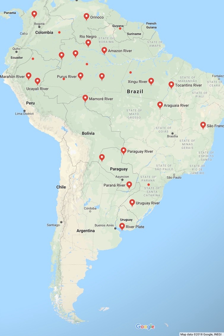
Top 20 Longest Rivers of South America
Longest Rivers in South America:
1. Amazon–Ucayali–Tambo–Ene–Apurímac
The Amazon river system is the longest of its kind in South America with a total length of 3,999 miles, starting from the Apurímac River on the west coast of South America, and traveling northeast to the Atlantic Ocean on the east coast. It’s also the biggest river in South America in terms of the volume of water it drains into the Atlantic Ocean, with a total discharge of 7,400,000 cubic feet per second. Multiple rivers are located to the north and south of the Amazon River, and contribute their waters to create the biggest river in South America.
The Apurímac river originates from a ridge on the Mismi mountain in the Arequipa Province in Peru, then flows for 450 miles until it reaches the Ene River. From there, the Ene and Perene’ rivers join together and form the Tambo section of the Amazon for about 99 miles.
As the river makes its way to the northeast, it once again changes to the Ucayali River at around 1,659 miles from its source on the Mismi mountain. The Ucayali is the final headwater of the Amazon River basin before it discharges into the Atlantic Ocean. Numerous rivers feed the Amazon as it traverses from west to east, helping it maintain its vastness and volume.
2. Río De La Plata–Paraná–Rio Grande
The Río De La Plata–Paraná–Rio Grande is a series of rivers that run through Brazil, Paraguay, and Argentina, and is the second-largest river in South America. The Río De La Plata, or River Plate in English, is an estuary that’s formed by the joining of the Paraná and Uruguay Rivers. The river itself is about 180 miles long, and is about 140 miles wide at its mouth where it meets the Atlantic Ocean near Buenos Aires.
The Paraná River runs through Brazil, Paraguay, and Argentina for a total of 3,030 miles, making it another one of the longest rivers in South America, and second to the Amazon River. It begins where the Paranaiba and Rio Grande rivers come together in southern Brazil, then heads a southwestern direction for about 385 miles until it reaches Paraguay. From there, it forms a boundary between Paraguay and Brazil, then meanders further south until it meets with the Uruguay River and becomes part of the Río De La Plata
The Rio Grande begins in the Mantiqueira Mountains in Minas Gerais, Brazil, and heads on a northwest path for 677 miles before joining with the Paraná River in Brazil.
3. Tocantins–Araguaia
The Tocantins-Araquaia Rivers are two river systems that cover about 9.5% of the territory of Brazil, and combine together near São João in the northern part of the country. The Araguaia River is 1,632 miles long from its origins in the Brazilian Highlands to where it combines with the Tocantins River. It forms borders between multiple states in Brazil, and contains a biologically rich section of the eastern Amazon. Over 700 species of birds and 300 species of fish call the river home, along with large populations of river-dwelling mammals.
The Tocantins River is located to the east of the Araguaia River and has its origin on the central plateau of Goiás. It heads north for about 1,677 miles from start to finish, and is a tributary of the Amazon River, although it’s technically a separate system with its own drainage basin. The river is of limited use for transportation due to the fact it has multiple waterfalls and a hydroelectric facility that prevents water vessels from easily traversing the length of the river. It’s also one of the three clearwater rivers that connect to the Amazon River.
4. Madeira–Mamoré–Grande–Caine–Rocha
The Madeira–Mamoré–Grande–Caine–Rocha river system is 2,100 miles long, and is the third largest river in South America. The river’s course goes through Brazil, Peru, and Bolivia. The Madeira River itself is 900 miles long and is a major tributary of the Amazon River, accounting for 15% of the Amazon’s water volume. The Mamoré, a tributary of the Madeira, is about 2,100 miles in length. The Grande River is the originating river of the Mamoré with its source located in the Mantiqueira Mountains of south-central Brazil. It descends on a west-northwest path towards the Brazilian states of Minas Gerais and São Paulo for about 845 miles before joining the Upper Paranaíba River.
5. Purús
The Purús River has the distinction of being the fifth of the longest rivers in South America as well as being the most crooked, and has a total length of 1,995 miles. The river originates in Peru, and forms part of the boundary between Peru and Brazil in the Brazilian state of Acre. The path of the river is a significant one as it flows through the Arapixi Extractive Reserve, then goes on to form the western boundary of the Purús National Forest. It then borders the Medio Purús Extractive Reserve, flows through the Canutama Extractive Reserve, and the Piagaçu-Purus Sustainable Development Reserve before flowing into the Amazon River.
6. São Francisco
The São Francisco River is the longest river in Brazil, and runs for its entirety through the country. It’s also the fourth largest river in South America with a length of 1,811 miles. The source of the river is located in the Canastra mountains, located in the Brazilian state of Minas Gerais, and flows northward until it gradually turns east around the towns of Barra and Xique-Xique. The São Francisco forms the borders of five states along its route as well as playing an important role of supplying water to the semi-arid region of Brazil. As the river traverses towards the Atlantic ocean, it passes through four sections that see it descend in elevation. A total of 168 streams and rivers feed the São Francisco on its pathway.
7. Araguaia
Another one of the biggest rivers in South America is the Araguaia. Its volume is almost equal to that of the Tocantins with which it merges in the northeastern portion of Brazil. It’s 1,632 miles long, and has an average discharge of 218,000 cu ft/s compared to the Tocantins’ 227,000 cu ft/s. The Araguaia River forms the border of four states in Brazil, and has 11 major communities along its riverbanks. The Emas National Park and the Araguaia National Park help protect sections of the river from development, and other sections feature beach-like settings with sandbanks that are perfect for visitors from May to October.
8. Japurá (Rio Yapurá)
The Japurá, or Caquetá-Japurá, is a tributary of the Amazon river that originates in Colombia and has a length of 1,750. It’s the fourth longest river in South America that feeds the Amazon river. The first two-thirds of the river is called Caquetá as it flows through Colombia, then becomes the Japurá when it enters into Brazil. The Caquetá-Japurá is classified as a turbid river due to its murky coloration that is the result of clearwater and backwater tributaries. Two federally protected reserves, the Chiribiquete National Park and Cahuniari National Park, are located along the banks of the Caquetá-Japurá in Colombia.
9. Paraguay (Rio Paraguay)
The Paraguay River is the fifth largest river in South America and stretches 1,584 miles from its origins in the Mato Grosso area of Brazil to its confluence with the Paraná River. The river runs on a south-southwestern course through the country of Paraguay, dividing it into two halves. The western section of the country is largely uninhabited, and the eastern section holds about 98% of the country’s population. Towards the lower end of the river in the south, it forms the border with Argentina, and eventually ceases its course as it runs into the Paraná River.
10. Pilcomayo
The Pilcomayo River is the main tributary to the Paraguay River, and has a length of 1,550 miles. Its source is located in the Andes Mountains. It starts in the Oruro Department in Bolivia, and flows in a southeast direction to eventually cross through the Gran Chaco plains in Paraguay. As the river flows through the Gran Chaco plains, it forms a portion of the border between Argentina and Paraguay. At one point during its course, the river silts up, then splits into two large branches known as the North and South Pilcomayo. Eventually, the two sections rejoin to create the Lower Pilcomayo.
11. Juruá
The Juruá River is one of the longest rivers in South America with a length of 2,040 miles. It’s known as the most-winding river due to its frequent switchbacks as it makes its way north, then eastward, to the Amazon River. Few people live along the course of the Juruá, but the river plays a vital role in supplying water to the rainforests along its banks, and multiple nature reserves that it flows through.
12. Negro
The Negro River, also known as Rio Negro or Guainia, contributes 14% of the volume to the Amazon River basin and is one of the biggest rivers in the world by discharge volume of 1,269,300 cu ft/s. The river is also the largest backwater river in the world. The source of the Negro is found in Columbia, where it’s known as the Guainia River. It flows east-northeast through the Puinawai National Reserve before it reaches Columbia and forms part of the border between Columbia and Venezuela. It then changes course and flows southeast through several major towns and reservations on its way to empty into the Amazon River.
13. Orinoco
The Orinoco is one of the longest rivers in South America with a total length of 1,400 miles from its origin in Venezuela to its termination at the Atlantic Ocean. In terms of water discharge volume, it’s the fourth largest river in the world. The Orinoco River was discovered by Columbus in 1498, and is one of the most well-documented rivers in South America. Explorers have traversed its waterways for hundreds of years with one explorer, Alexander Von Humboldt, discovering the pink river dolphins in 1800. There are four different sections of the river that are known as the Upper, Middle, and Lower Orinoco, and the last stretch is named Delta Amacuro.
14. Xingu
The Xingu River is located in northern Brazil, and is a tributary of the Amazon River. At 1,019 miles long, it’s one of the shorter rivers, but is the largest clearwater river in the Amazon basin. The Xingu provides about 5% of the total volume of water of the Amazon River. The first Indigenous Park in Brazil, a reserve of land set aside for indigenous tribes, was formed along the riverbanks of the Xingu to protect tribal lands and preserve access to the river.
15. Northern Salado
The Northern Salado River is located in the Buenoes Aires province of Argentina, and originates at Lake El Chañar at a relatively low elevation of 130 feet above sea level. The river flows southeast for about 400 miles until it reaches the Samborombón Bay and empties into the Atlantic Ocean. The Salado River plays an important role in the irrigation of the plains of the Pampas, a fertile grassland that stretches across 460,000 square miles of southeastern South America.
16. Tapajós
The Tapajós is one of three clearwater rivers that are tributaries to the Amazon River, and it supplies 6% of the water in the Amazon Basin, making it one of the largest tributaries in the system. The river is 1,200 miles long, and forms the border between the Para and Amazonas states of Brazil. The Tapajós River plays a crucial role in supporting wildlife, human habitation, and agriculture along its course with unique species of fish calling the river home, 10 indigenous tribes living along the river basin, and helping to produce one-third of the world’s soy.
17. Guaporé (Itenez)
The Guaporé River is located in western Brazil and the northeastern portion of Bolivia, and forms a portion of the border between the two countries. It’s 780 miles long and is a part of the border of the Guaporé Biological Reserve, an important nature reserve that’s rich in fish, plant, bird, and mammal life.
18. Uruguay
The Uruguay River is located in southern Brazil, and begins its journey as the Pelotas River about 40 miles inland from the Atlantic coast in Santa Catarina, Brazil. It gets its name Uruguay after it meets up with the Canoas River, and heads west/southwest until it forms the border between Argentina and Brazil. The Uruguay River runs for 990 miles until it reaches the Paraná River. The two rivers then combine to form the estuary of the Rio de la Plata River.
19. Beni
The Beni River comes into existence in the northern section of Bolivia. The river basin is formed by multiple confluents that come together to form the origin of the river in an area north of La Paz, Bolivia’s capital. It runs a course of around 1,000 miles before it reaches the Mamoré River in Villa Bella at the border between Bolivia and Brazil. From there, the combined rivers flow into the Madeira River, which eventually connects with the Amazon River in the northeast of Brazil.
20. Içá (Putumayo)
The Içá River, also known as the Putumayo River, is a tributary of the Amazon river and forms part of the border of Colombia and Ecuador, and Columbia and Peru. All three South American nations refer to the river as the Putumayo, but the Brazilians call it the Içá River when it crosses the border. The waters of the nearly 1,000 mile-long river are smooth and flat with no rapids, making it a popular waterway for boat traffic.
The Içá/Putumayo River originates in the Andes mountains with the La Cocha Lake serving as its source. The Guamués River forms the initial leg of the Içá/Putumayo, and is known as the Guamués until it reaches Puerto Asís, Columbia, where it becomes known as the Putumayo. From there, the river travels southeast until it joins the Amazon in Brazil.