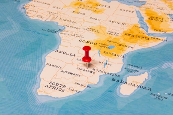
Zimbabwe is located in the Southern Africa region at latitude -19.015438 and longitude 29.154857 and is part of the African continent.
The DMS coordinates for the center of the country are:
- 19° 0' 55.58'' S
- 29° 9' 17.49'' E
You can see the location of Zimbabwe on the world map below:
Zimbabwe Neighboring Countries
The neighboring countries of Zimbabwe (ZW) are:
- Botswana (BW)
- Mozambique (MZ)
- South Africa (ZA)
- Zambia (ZM)
Zimbabwe is a landlocked country, which means it does not have direct access to the open ocean.
Zimbabwe Related Content
Zimbabwe Key Facts
| Country | Zimbabwe |
| Coordinates | Latitude: -19.015438 Longitude: 29.154857 |
| Country Codes | Alpha 2: ZW Alpha 3: ZWE |
| Country Flag Emoji | 🇿🇼 |
| Int. Phone Prefix | +263 |
| Capital city | Harare |
| Continent Subcontinent | Africa Southern Africa |
| Country Area | 390,757 sq km |
| Population 2025 | 16,950,795 World Rank: 73 |
| Median Age | 18.1 |
| Life expectancy | 63.1 |
| Major languages | Shona (official; most widely spoken), Ndebele (official, second most widely spoken), English (official; traditionally used for official business), 13 minority languages (official; includes Chewa, Chibarwe, Kalanga, Koisan, Nambya, Ndau, Shangani, sign language, Sotho, Tonga, Tswana, Venda, and Xhosa) |
| UTC/GMT Time | Number of time zones: 1
|
| Internet TLD | .zw |
| Biggest Airport | Harare International Airport (HRE) |
| Average temperature | 21.00 °C 69.80 °F |
| Administrative Divisions | 10 provinces |
| Political system | Presidential representative democratic republic |
Zimbabwe Economy Facts
| World Bank Income Group | Lower middle income |
| World Bank Region | Sub-Saharan Africa |
| Currency | US Dollar (ZWD) |
| GDP in 2025 | $51.2 (billions of USD) World Rank: 97 |
| GDP per capita in 2025 | $3,021 World Rank: 164 |
| Major Industries / Economic Sectors | Agriculture, manufacturing, energy, services |
| Top 5 Import Countries | South Africa, China, Democratic Republic of the Congo, India, United Arab Emirates |
| Top 5 Export Countries | South Africa, China, Democratic Republic of the Congo, Mozambique, Botswana |
Biggest Cities in Zimbabwe
Here are the largest cities in Zimbabwe based on 2024 data:
| City | Population |
|---|
| Harare | 1,542,813 | Bulawayo | 665,952 | Chitungwiza | 371,246 | Mutare | 224,802 | Gweru | 158,200 | Kwekwe | 119,863 | Kadoma | 117,381 | Ruwa | 94,083 | Chinhoyi | 90,800 | Masvingo | 90,286 |
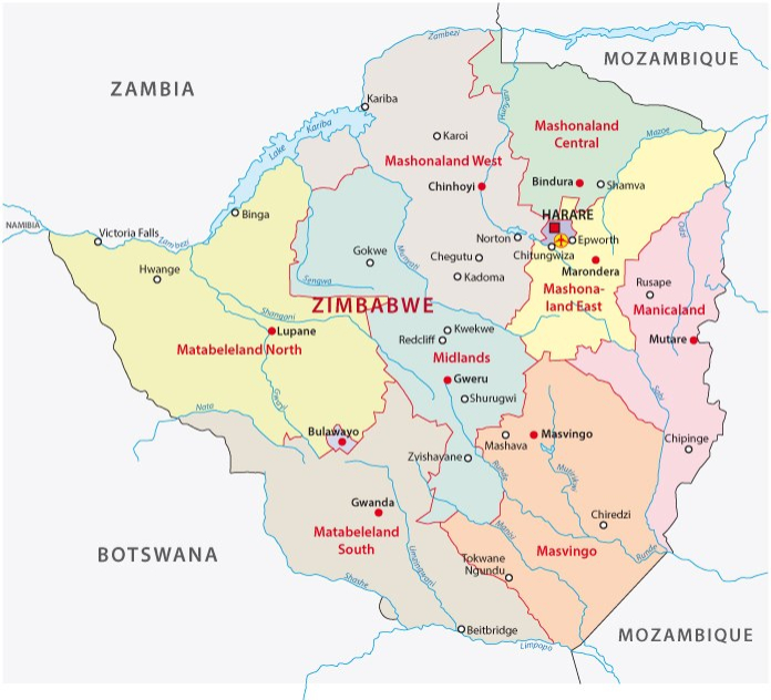
Map of Zimbabwe with the Largest Cities
Other Countries in the Southern Africa Region
- Where are the Seychelles?
- Where are the French Southern and Antarctic Lands?
- Where is Angola?
- Where is Botswana?
- Where is Burundi?
- Where is Eswatini (formerly named Swaziland)?
- Where is Kenya?
- Where is Lesotho?
- Where is Madagascar?
- Where is Malawi?
- Where is Mauritius?
- Where is Mayotte?
- Where is Mozambique?
- Where is Namibia?
- Where is Réunion?
- Where is Rwanda?
- Where is Saint Helena?
- Where is South Africa?
- Where is South Sudan?
- Where is the British Indian Ocean Territory?
- Where is the Congo?
- Where is Uganda?
- Where is Zambia?
Zimbabwe Political Map and Regions
Zimbabwe on the African continent is divided into 10 provinces. These provinces are divided into 59 districts.
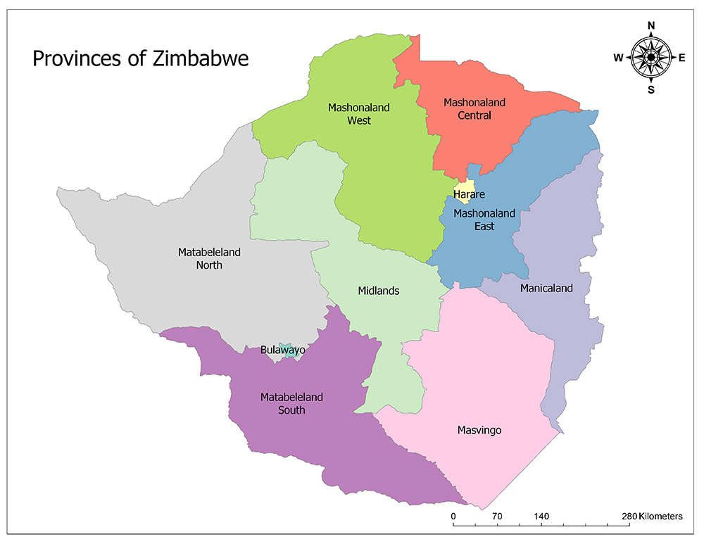
Ten Provinces of Zimbabwe
Zimbabwe is divided into ten provinces, the highest administrative division. Provinces of Zimbabwe are Bulawayo, Harare, Manicaland, Mashonaland Central, Mashonaland East, Mashonaland West, Masvingo, Matabeleland North, and Matabeleland South.
Bulawayo
Bulawayo is the second largest city in the state of Zimbabwe. According to the 2016 official census, 1,200,337 people live in the city, which is also the central city of the country with the same name. The area is 1,706 square kilometers.
The name of the city means the battlefield in Ndebele, one of the official languages of the country. This means that the British troops defeated the local tribes and obtained these regions and as a result of this, the settlement of the region with the contributions of Cecil Rhodes, gave the name of the city that was established today.
Harare
Harare is the capital and the largest province of Zimbabwe. Harare, which has provincial status, has a population of 1,606,000 according to 2013 official census results across all provincial borders. The area is 960 square kilometers.
The province is located in the northeastern part of the country. Economic life in the province is quite lively. Tobacco, corn, cotton, and citrus are sold from this country to the world.
Manicaland
Manicaland is one of Zimbabwe’s ten existing provinces. Manicaland is adjacent to the Midlands in the west, Mashonaland East in the north, Masvingo in the northwest, and Mozambique in the south and west. According to the official census results of 2012, 1,752,698 people live in the province. The area is 36,459 square kilometers. The city of Mutare is the administrative capital of the province and the province is divided into seven districts.
Mashonaland Central
Mashonaland Central is one of Zimbabwe’s ten existing provinces. The central province of Mashonaland is adjacent to Mashonaland West in the west, Mashonaland East in the southeast, Harare in the east, and Mozambique in the north. According to the official census results of 2012, 1,152,520 people live in the province. The area of the province is 28,347 square kilometers. Bindura is the administrative capital of the province and the province is divided into seven districts.
Mashonaland East
Mashonaland East is one of the ten provinces of Zimbabwe in total. Mashonaland East is adjacent with the Midlands in the south, Mashonaland in the north, Harare and Mashonaland in the west, and Manicaland and Mozambique in the east. According to the official census results of 2012, 1,344,955 people live. The area of the province is 32,230 square kilometers. The city of Marondera is the administrative capital of the province and the province is divided into eight districts.
Mashonaland West
Mashonaland West is one of the ten existing provinces of the African country of Zimbabwe. The province is adjacent to the Midlands in the south and southwest, Mashonaland in the northeast, Harare and Mashonaland in the east, Matabeleland in the west and Zambia in the west. According to the official census results of 2012, 1,501,656 people live in the province. The area is 57,441 square kilometers. Chinhoyi is the administrative capital of the province and is divided into six districts.
Masvingo
Masvingo is one of Zimbabwe’s ten existing provinces. Masvingo is adjacent to the Midlands in the northwest, Manicaland in the northeast, Matabeleland in the southwest, Mozambique and the Republic of South Africa in the east. Masvingo also includes the area called Zimbabwe the Great, where there are important historical monuments in the name of Zimbabwe’s history. Due to the visit of these historical monuments, the province attracts many tourists to the region. According to the official census results of 2012, 1,485,090 people live in the province. The area is 36,459 square kilometers. Masvingo is the administrative capital of the province and the province is divided into seven districts.
Matabeleland North
Matabeleland North is one of the ten provinces of Zimbabwe in total. It is adjacent to the Midlands in the east, Mashonaland in the northeast, Bulawayo and Matabeleland in the south, Zambia in the north and Botswana in the west. The 100 m borderline with Namibia in the northwest is controversial.
This region, which is the only quadrangular border region in the world and which is connected to this border, is an unacceptable border point because it does not mutually formalize the border agreements of Botswana, Zambia, Zimbabwe and Namibia countries.
According to the official census results of 2012, 749,017 people live in the province. The area of the region is 75,025 square kilometers. Lupane is the administrative capital of the province and the province is divided into six districts.
Matabeleland South
Matabeleland South is one of the ten provinces of Zimbabwe in total. The southern province of Matabeleland is adjacent to the Midlands in the northeast, the Matabeleland to the north and Bulawayo to the north, Masvingo to the east, Botswana to the southwest and the Republic of South Africa to the south.
According to the official census results of 2012, 683,893 people live. The area is 54,172 square kilometers. Gwanda is the administrative capital of the province and the province is divided into six districts.


