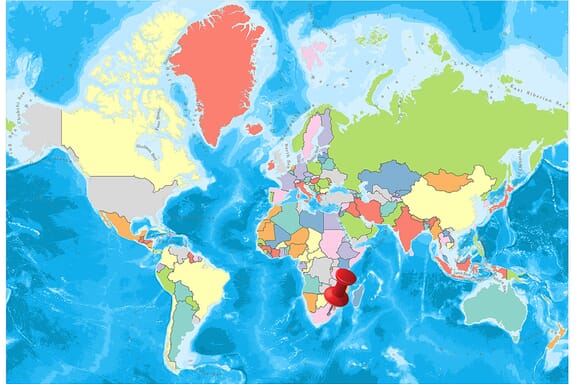
Lesotho is located in the Southern Africa region at latitude -29.609988 and longitude 28.233608 and is part of the African continent.
The DMS coordinates for the center of the country are:
- 29° 36' 35.96'' S
- 28° 14' 0.99'' E
You can see the location of Lesotho on the world map below:

Lesotho Neighboring Countries
The neighboring countries of Lesotho (LS) are:
- South Africa (ZA)
Lesotho is a landlocked country, which means it does not have direct access to the open ocean.
Lesotho Related Content
Lesotho Key Facts
| Country | Lesotho |
| Coordinates | Latitude: -29.609988 Longitude: 28.233608 |
| Country Codes | Alpha 2: LS Alpha 3: LSO |
| Country Flag Emoji | 🇱🇸 |
| Int. Phone Prefix | +266 |
| Capital city | Maseru |
| Continent Subcontinent | Africa Southern Africa |
| Country Area | 30,355 sq km |
| Population 2021 | 2,159,067 World Rank: 143 |
| Median Age | 22.1 |
| Life expectancy | 53.1 |
| Major languages | Sesotho (official) (southern Sotho), English (official), Zulu, Xhosa |
| UTC/GMT Time | Number of time zones: 1
|
| Internet TLD | .ls |
| Biggest Airport | Moshoeshoe I International Airport (MSU) |
| Average temperature | 11.85 °C 53.33 °F |
| Administrative Divisions | 10 districts |
| Political system | Parliamentary democracy |
Lesotho Economy Facts
| World Bank Income Group | Lower middle income |
| World Bank Region | Sub-Saharan Africa |
| Currency | Lesotho Loti (LSL) |
| GDP in 2020 | $2.3 (billions of USD) World Rank: 168 |
| GDP per capita in 2020 | $1,051 World Rank: 169 |
| Major Industries / Economic Sectors | Agriculture, manufacturing, energy, services |
| Top 5 Import Countries | South Africa, China, United States, India, Botswana |
| Top 5 Export Countries | South Africa, United States, China, India, Japan |
Biggest Cities in Lesotho
Here are the largest cities in Lesotho based on 2021 data:
| City | Population |
|---|
| Maseru | 330,790 | Teyateyaneng | 75,115 | Mafeteng | 57,059 | Leribe | 47,675 | Maputsoe | 32,117 | Mohale's Hoek | 24,992 | Quthing | 15,000 | Butha-Buthe | 10,000 | Mokhotlong | 8,809 | Thaba-Tseka | 5,423 |
Map of Lesotho with the Largest Cities
Other Countries in the Southern Africa Region
- Where are the Seychelles?
- Where is Angola?
- Where is Botswana?
- Where is Burundi?
- Where is Eswatini (formerly named Swaziland)?
- Where is Kenya?
- Where is Madagascar?
- Where is Malawi?
- Where is Mauritius?
- Where is Mozambique?
- Where is Namibia?
- Where is Rwanda?
- Where is South Africa?
- Where is South Sudan?
- Where is the Congo?
- Where is Uganda?
- Where is Zambia?
- Where is Zimbabwe?
Geography
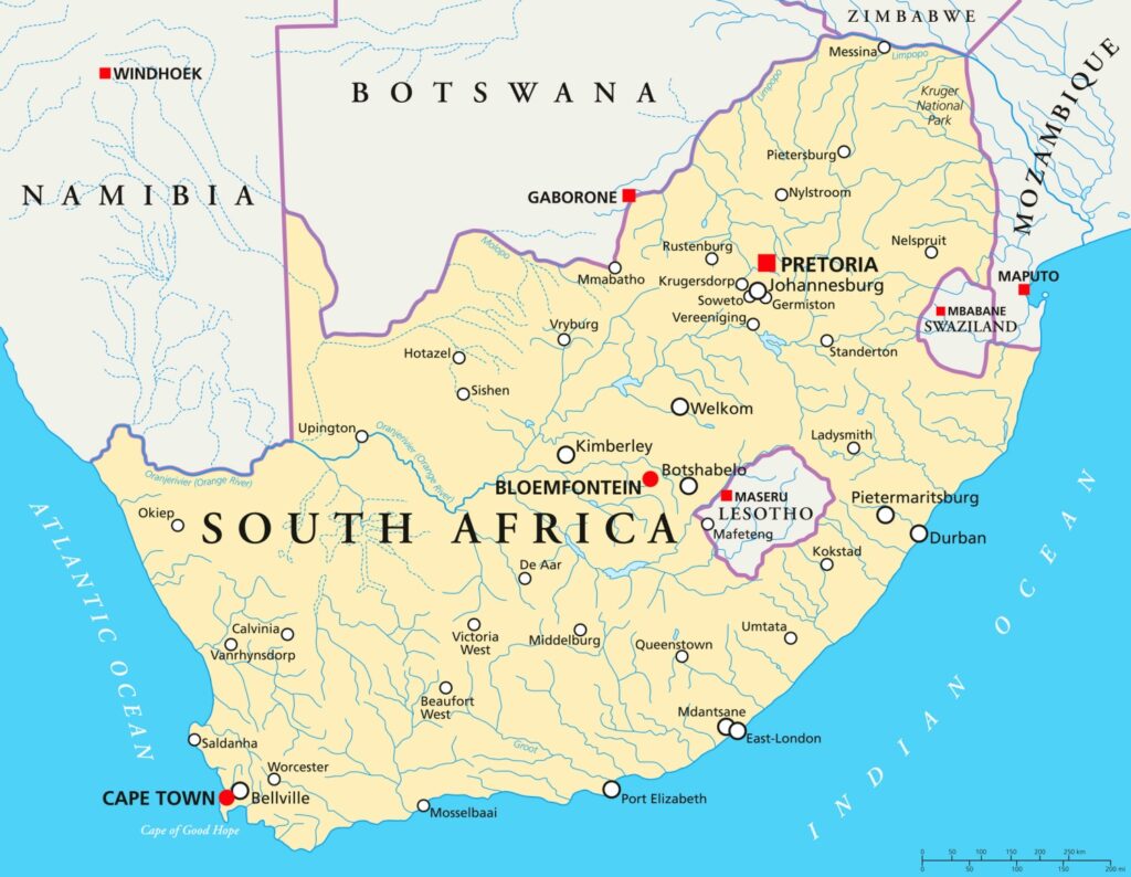
Lesotho is a country south of the African continent. The entire territory of the country is surrounded by the territory of the Republic of South Africa.
Maseru is the capital of the country, which was called Basutoland until 1966 when the independence from the United Kingdom was gained and governed by parliamentary monarchy.
Lesotho Map

The western regions of the country are made up of high-valley highlands and sandstones containing the main settlements of the country. The altitude in these regions is measured between 1,400 m and 1,700 m and river beds and small mountains are among the characteristics of the land.
The high plateaus and mountains, which are located in the eastern part of the country and consisting of basalt, are over 2.000 m. Deep river beds, mountains and mountain ranges in the high plateaus in this section are among the characteristics of the region.
The Drakensberg mountain range extends from the southwestern part of the country to the northern part. Mount Thabana Ntlenyana, which is the highest point of the mountain range called Maloti Mountain in Lesotho, with a total of 3.482 m, constitutes the highest point of both Lesotho and the southern part of the African continent.
The lowest point of the country is 1.400 m and it joins the Oranje and Makhaleng rivers. With these elevations, Lesotho is the only country in the world where the average rise of the whole country is 1,000 m and above between the independent states of the world and 80% of the country’s territory is 1,800 m.
The output sources of the Oranje and Kaledon rivers, one of the most important water sources of the southern part of the African continent, are located in Lesotho. Like many rivers in the country, these canyons form deep canyons.
Maletsunyane waterfall, which is located near the Semonkong settlement and the second longest in the southern part of Africa due to its uninterrupted flow, flows down from a height of 192 m. The formation of soft sandstone from the plateaus to the high mountainous areas may cause erosions frequently due to the increasing population density. Only 11% of the territory of the country is suitable for agricultural activities.
The country’s largest natural resources are water reservoirs, with a small number of diamonds and other minerals. Due to the abundance of water reserves in the country, many dams have been started and Katse Dam has the biggest dam title in these areas.
Governance
According to the constitution adopted on 2 April 1993, the form of government of the country was expressed as a two-chamber parliamentary monarchy. In the constitution, an independent judiciary system is guaranteed, with emphasis on separation of powers. The law is also guaranteed in matters such as human rights, freedom of religion and conscience, and privacy.
Climate
Since the country is located in the southern hemisphere section, the seasons are experienced as the opposite of the northern hemisphere countries. There is a mild climate throughout the country. The winter months are mostly cold in the months of June and August, and snowfall can be experienced in high areas in the eastern part of the country. Even in the winter, the sun often shows itself during the day, and during the year the sun can be observed for approximately 300 days.
The temperature is high in November-March when the summer is experienced. There are 100 days of torrential rainfall in most of the country in summer.
Due to the high altitude in the country, very high-temperature differences may occur during the day. In addition to the night temperature, which can be measured as -15 ° C in winter, more than 30 ° C in summer can be measured.
The average temperature measured throughout the year in Maseru is 15 ° C. Very high points such as the mountain of Drakensberg are experiencing snow all year round.
Religion
90% of the population of Lesotho has a very large proportion of the Christian faith.
Nearly half of the Christian religious communities fulfill their religious requirements according to the Catholic sect and 40% according to the Protestant sect, while 10% believe in the local African Christianity.
The remaining 10% in the country believes in African nature religions and few believe in Islam and Hinduism.
Industry and Tourism
Lesotho, based on national income per capita, is one of the poorest countries in the world with 43% of its population earning less than one dollar per day according to 2003 data. 60% of the population operates in the agricultural area where two-thirds of the country’s total income is obtained.
The most common crop cultivated throughout the country is corn, and many people make agriculture for their own consumption. In the country where there is an important place in animal husbandry, a part of the population is working as a seasonal worker.
Especially after 2011, with the production of diamonds obtained from high altitudes, positive developments took place in the economy and a 5.2% growth rate was achieved.
The country, which is rich in water, transforms these resources into electricity with the dam formations named as Lesotho Highland Water Project and thus meets the country’s huge electricity needs.
A large part of the electricity and water obtained here is sold to the neighboring country of South Africa.
Sports
The football, the most popular sport in the country, is managed by the Lesotho Football Association, founded in 1932. The national league is not at the desired level in Lesotho, as good footballers across the country have gone to the Republic of South Africa to play under better conditions.
Lesotho national league is held with the participation of sixteen teams. Lesotho national football team, named as Likuena by fans, ranked 152nd in the FIFA ranking announced in February 2016 and the highest ranking in 2003 was 120th.
Other than football in Lesotho, judo, taekwondo, boxing, long-distance running are other types of sports.