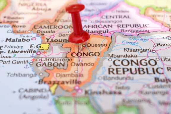
Congo is located in the Southern Africa region at latitude -0.228021 and longitude 15.827659 and is part of the African continent.
The DMS coordinates for the center of the country are:
- 0° 13' 40.88'' S
- 15° 49' 39.57'' E
You can see the location of Congo on the world map below:
Congo Neighboring Countries
The neighboring countries of Congo (CG) are:
- Angola (AO)
- Cameroon (CM)
- Central African Republic (CF)
- Congo (the Democratic Republic of the) (CD)
- Gabon (GA)
Maritime Borders
Republic of the Congo borders with the Atlantic Ocean.
Congo (the) Related Content
Congo Key Facts
| Country | Congo (the) |
| Coordinates | Latitude: -0.228021 Longitude: 15.827659 |
| Country Codes | Alpha 2: CG Alpha 3: COG |
| Country Flag Emoji | 🇨🇬 |
| Int. Phone Prefix | +242 |
| Capital city | Brazzaville |
| Continent Subcontinent | Africa Southern Africa |
| Country Area | 342,000 sq km |
| Population 2025 | 6,484,437 World Rank: 110 |
| Median Age | 18.2 |
| Life expectancy | 66.0 |
| Major languages | French |
| UTC/GMT Time | Number of time zones: 1
|
| Internet TLD | .cg |
| Biggest Airport | Maya-Maya Airport (Brazzaville) |
| Average temperature | 27.00 °C 80.60 °F |
| Administrative Divisions | 12 departments |
| Political system | Presidential representative democratic republic |
Congo Economy Facts
| World Bank Income Group | Lower middle income |
| World Bank Region | Sub-Saharan Africa |
| Currency | CFA Franc (XAF) |
| GDP in 2025 | $16.3 (billions of USD) World Rank: 143 |
| GDP per capita in 2025 | $2,515 World Rank: 171 |
| Major Industries / Economic Sectors | Oil and gas, agriculture, forestry, manufacturing |
| Top 5 Import Countries | China, France, United States, South Africa, Belgium |
| Top 5 Export Countries | China, United States, France, Italy, South Korea |
Biggest Cities in Congo
Here are the largest cities in Congo based on 2024 data:
| City | Population |
|---|
| Brazzaville | 1,982,000 | Pointe-Noire | 1,032,000 | Dolisie | 121,000 | Nkayi | 103,000 | Kayes | 58,737 | Impfondo | 48,939 | Ouesso | 40,667 | Owando | 35,698 | Sibiti | 33,122 | Loutete | 27,726 |
Map of Congo with the Largest Cities
Other Countries in the Southern Africa Region
- Where are the Seychelles?
- Where are the French Southern and Antarctic Lands?
- Where is Angola?
- Where is Botswana?
- Where is Burundi?
- Where is Eswatini (formerly named Swaziland)?
- Where is Kenya?
- Where is Lesotho?
- Where is Madagascar?
- Where is Malawi?
- Where is Mauritius?
- Where is Mayotte?
- Where is Mozambique?
- Where is Namibia?
- Where is Réunion?
- Where is Rwanda?
- Where is Saint Helena?
- Where is South Africa?
- Where is South Sudan?
- Where is the British Indian Ocean Territory?
- Where is Uganda?
- Where is Zambia?
- Where is Zimbabwe?
Departments of the Republic of the Congo
The Republic of the Congo, the African country, is governed by a unitary state structure and has a total of 12 departments. Pointe-Noire Municipality, which is one of the departments managed by a central administration, has a different status as the Capital City Brazzaville.
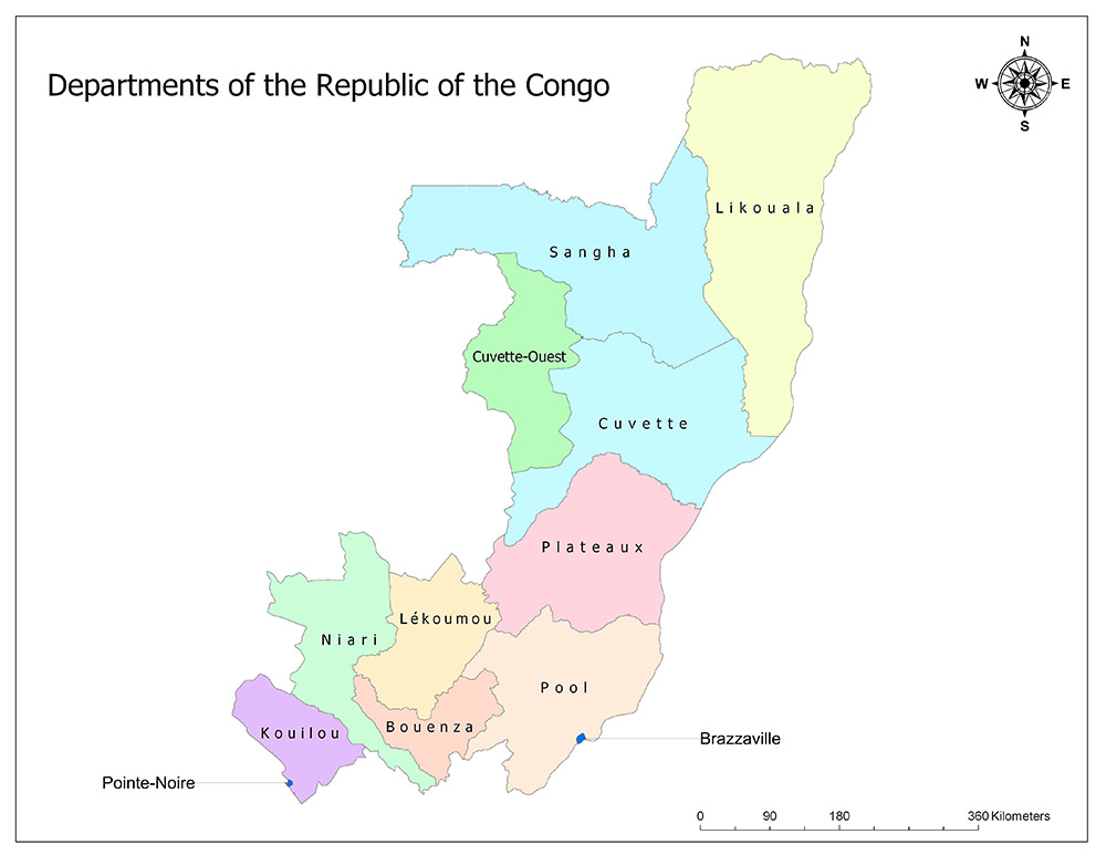
Twelve Departments of the Republic of the Congo
The Republic of Congo is divided into twelve departments as the highest administrative division. These departments replaced the old regions in 2002. Departments of the Republic of the Congo are Kouilou, Niari, Lékoumou, Bouenza, Pool, Plateaux, Cuvette, Cuvette-Ouest, Sangha, Likouala, Brazzaville and Pointe-Noire.
Kouilou
Kouilou is one of the twelve departments in the Republic of Congo. The department is located in the south of the country. The administrative capital of the region is Hinda. Although Pointe-Noire is the central city of the department, it is managed as a separate municipality. According to the estimated census data for the year 2010, 913,299 people live in Pointe-Noire. 829,134 of this population live within the borders of Pointe-Noire municipality. The Department has a continental border with Niari in the east, Gabon in the north, Cabinda in the south, and Pointe-Noire in the southwest, and the west coast of the Atlantic Ocean. The area of the department is 13,694 square kilometers.
Niari
Niari is one of the eleven departments of the Republic of Congo. The province of Niari is one of the mid-sized departments of the country in terms of surface area, while it is one of the small provinces of the country in terms of population. The department is adjacent to Lékoumou to the east, Bouenza to the southeast, Kouilou to the southwest, Gabon to the north, Cabinda to the Democratic Republic of Congo and Angola to the south. The administrative capital of the department is Dolisie. The population of the region is 255,120 according to 2010 estimates and the area is 25,942 square kilometers.
Lékoumou
Lékoumou is one of the twelve existing departments of the Republic of Congo. Lékoumou department is one of the smallest departments of the country in terms of surface area and it is one of the small departments in terms of population. The department borders Niari in the west, Bouenza in the south, Plateaux in the northeast, Pool in the east and Gabon in the north. The administrative capital of the region is Sibiti. department to 2010 census data, 85,617 people live in the department. The area of the department is 20,950 square kilometers.
Bouenza
Bouenza is one of the twelve existing departments of the Republic of Congo. The department is bordered by Lékoumou in the north, Pool in the northeast, Niari in the west and Democratic Republic of Congo in the south. The administrative capital of the department is Madingou. According to the 2010 census data, 319,570 people live in the province. The area of the department is 12,265 square kilometers.
Pool
Pool is one of the twelve departments in the Republic of Congo. The department of Pool is one of the mid-sized departments of the country in terms of surface area, and it is one of the largest departments in terms of population due to its border with the capital city of Brazzaville. The department is bordered by Plateaux in the north, Lékoumou in the northwest, Bouenza in the southwest, Brazzaville in the south and the Democratic Republic of Congo both in the south and east. The administrative capital of the department is Kinkala. According to 2010 census data, 59,728 people live in the department. The area of the department is 33,955 square kilometers.
Plateaux
Plateaux is one of the twelve departments in the Republic of the Congo. Plateaux department is one of the middle-sized departments of the country in terms of surface area measurement, while it is one of the small departments in terms of population. The department has borders with Cuvette in the north, Pool in the south, West Cuvette in the northwest, Lékoumou and Gabon in the west and Democratic Republic of Congo in the east. The administrative capital of the department is Djambala. According to 2010 census data, 192,596 people live in the department. The area is 38,400 square kilometers.
Cuvette
Cuvette is one of the twelve departments of the Republic of Congo. The province of Cuvette is one of the country’s mid-sized departments in terms of surface area, while it is one of the smallest departments in the country in terms of population. The department borders Sangha in the north, West Cuvette in the west, Likouala in the northeast, Plateaux in the south, Gabon in the southwest, and Democratic Republic of Congo in the east. The administrative capital of the Department is Owando. According to the 2010 estimated census data, 152,433 people live across the Department. Its area is 46,060 square kilometers.
Cuvette-Ouest
Cuvette-Ouest is one of the twelve existing departments of the Republic of Congo. The province of Cuvette-Ouest is one of the mid-sized departments of the country in terms of surface area, while it is one of the smallest departments in terms of population. The department has borders with Sangha in the north, Cuvette in the east and Gabon in the west. The administrative capital of the department is Ewo. According to 2010 census data, 59,728 people live in the department . The area of the department is 28,790 square kilometers.
Sangha
Sangha is one of the twelve departments of the Republic of Congo. Sangha department is the second largest department of the country in terms of surface area and it is one of the medium-sized departments of the country in terms of population. The department is adjacent to Likouala in the east, Cuvette in the south, West Cuvette in the southwest, Central African Republic in the north, Cameroon in the northwest and Gabon in the west. The administrative capital of the department is Ouésso. According to 2010 census data, 81,326 people live in the department. The area is 55,800 square kilometers.
Likouala
Likouala is one of the twelve departments of the Republic of Congo. Likouala is the largest department of the country in terms of surface area, while it is one of the smallest departments in terms of population. The department borders Sangha in the west, Cuvette in the southwest, Central African Republic in the north and Democratic Republic of Congo in the east. The administrative capital of the department is Impfondo. According to 2010 census data, 97,206 people live in the department. The area is 66,044 square kilometers.
Brazzaville
Brazzaville is one of the twelve administrative departments of the Republic of Congo on the African continent, both the capital and the largest city. The city is built on the banks of the Congo River. The majority of the country’s population lives in the capital, Brazzaville. The city of Brazzaville is managed by a separate municipality within the country. Although it is the second smallest administrative center of the Republic of Congo with an area of 100 square kilometers, it is also the most populous city with a population of more than 1,400,000.
Pointe-Noire
Pointe-Noire is the second largest city in the Republic of the Congo. The city is built on the coast of the Atlantic Ocean. The second majority of the country’s population lives in this city after the capital Brazzaville. The city of Pointe-Noire is run by a separate municipality. Although it is the smallest administrative center of the Republic of Congo with a surface area of 44 square kilometers, it is also the second most populous city with a population of more than 820,000.


