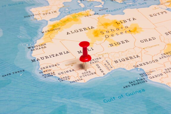
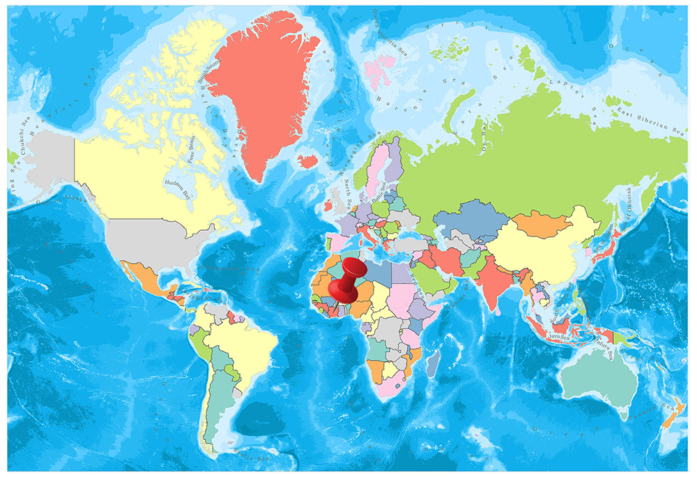
Côte d'Ivoire is located in the Northern Africa region at latitude 7.539989 and longitude -5.54708 and is part of the African continent.
The DMS coordinates for the center of the country are:
- 7° 32' 23.96'' N
- 5° 32' 49.49'' W
You can see the location of Côte d'Ivoire on the world map below:
Côte d'Ivoire Neighboring Countries
The neighboring countries of Côte d'Ivoire (CI) are:
- Burkina Faso (BF)
- Ghana (GH)
- Guinea (GN)
- Liberia (LR)
- Mali (ML)
Maritime Borders
Côte d'Ivoire bordres with the Gulf of Guinea.
Côte d'Ivoire Related Content
Côte d'Ivoire Key Facts
| Country | Côte d'Ivoire |
| Coordinates | Latitude: 7.539989 Longitude: -5.54708 |
| Country Codes | Alpha 2: CI Alpha 3: CIV |
| Country Flag Emoji | 🇨🇮 |
| Int. Phone Prefix | +225 |
| Capital city | Yamoussoukro |
| Continent Subcontinent | Africa Northern Africa |
| Country Area | 322,463 sq km |
| Population 2021 | 27,053,629 World Rank: 53 |
| Median Age | 17.6 |
| Life expectancy | 58.6 |
| Major languages | French (official), 60 native dialects of which Dioula is the most widely spoken |
| UTC/GMT Time | Number of time zones: 1
|
| Internet TLD | .ci |
| Biggest Airport | Port Bouet Airport (Abidjan) |
| Average temperature | 27.00 °C 80.60 °F |
| Administrative Divisions | 12 districts 2 autonomous districts |
| Political system | Presidential representative democratic republic |
Côte d'Ivoire Economy Facts
| World Bank Income Group | Lower middle income |
| World Bank Region | Sub-Saharan Africa |
| Currency | CFA Franc (XAF) |
| GDP in 2020 | $61.3 (billions of USD) World Rank: 76 |
| GDP per capita in 2020 | $2,326 World Rank: 140 |
| Major Industries / Economic Sectors | Agriculture, manufacturing, energy, services |
| Top 5 Import Countries | China, United States, France, Netherlands, Belgium |
| Top 5 Export Countries | Netherlands, United States, China, Belgium, France |
Biggest Cities in Côte d'Ivoire
Here are the largest cities in Côte d'Ivoire based on 2021 data:
| City | Population |
|---|
| Abidjan | 4,980,000 | Bouake | 659,233 | Yamoussoukro | 355,573 | Korhogo | 286,071 | Daloa | 255,168 | San-Pedro | 210,273 | Divo | 179,455 | Man | 146,974 | Gagnoa | 123,184 | Soubre | 108,933 |
Map of Côte d'Ivoire with the Largest Cities
Other Countries in the Northern Africa Region
- Where is Algeria?
- Where is Benin?
- Where is Burkina Faso?
- Where is Cabo Verde?
- Where is Cameroon?
- Where is Chad?
- Where is Comoros?
- Where is Djibouti?
- Where is Egypt?
- Where is Equatorial Guinea?
- Where is Eritrea?
- Where is Ethiopia?
- Where is Gabon?
- Where is Gambia?
- Where is Ghana?
- Where is Guinea-Bissau?
- Where is Guinea?
- Where is Liberia?
- Where is Libya?
- Where is Mali?
- Where is Mauritania?
- Where is Morocco?
- Where is Niger?
- Where is Nigeria?
- Where is Sao Tome and Principe?
- Where is Senegal?
- Where is Sierra Leone?
- Where is Somalia?
- Where is Sudan?
- Where is the Central African Republic?
- Where is Togo?
- Where is Tunisia?
Fourteen Districts of Ivory Coast
The African country of Côte d’Ivoire is divided into 14 autonomous districts, including two autonomous city districts.
The current districts of the Ivory Coast were formed as a result of the administrative reform carried out on 28 September 2011, which replaced the country’s formerly designated nineteen regions. In 2021, the 12 non-city districts were made autonomous, resulting in 14 total autonomous districts.
These districts are divided into 31 regions, which are divided into 109 departments.
 Showing Regions and Major Cities")
Ivory Coast is divided into 14 districts. These districts are Abidjan, Bas-Sassandra, Comoé, Denguélé, Gôh-Djiboua, Lacs, Lagunes, Montagnes, Sassandra-Marahoué, Savanes, Vallée du Bandama, Woroba, Yamoussoukro and Zanzan.
Abidjan
Abidjan is the largest city and capital of Cote d’Ivoire. It is known as Paris of West Africa. Abican has a population of around 3 million and is one of the most populous cities in Africa. It attracted many French and neighboring citizens and turned into a cosmopolitan center. Abidjan is one of the most popular cities of West Africa with its tall buildings and the lake of the sea. The city has a surface area of 818 square kilometers.
Bas-Sassandra
Bas-Sassandra is one of the 14 administrative districts of Cote d’Ivoire. The district is located in the southwestern part of the country. The district’s capital is San-Pédro. The area has a surface area of 25,800 square kilometers and has a population of 2,280,548 according to 2014 data. Bas-Sassandra is divided into three sub-regions. These regions are Gbôklé, Nawa, and San-Pédro.
Comoé
Comoé is one of the 14 administrative districts of Côte d’Ivoire. The district is in the southeast corner of the country. It has the border with the west, with the district of Zanzan in the north, with the district of Lacs and the district of Lagunes in the east, and with the Atlantic Ocean in the south. Abengourou is the capital of the district. The district has a surface area of 14,173 square kilometers and according to 2014 data, there is a population of 1,203,052. Comoé is divided into two sub-regions. These regions are Indénié-Djuablin and Sud-Comoé.
Denguélé
The Denguélé District is one of the 14 administrative districts of Cote d’Ivoire. The district is located in the northwest corner of the country. The capital of the district is Odienné. The district has a surface area of 20,997 square kilometers and has a population of 289,779 according to 2014 data. Denguélé is divided into two sub-regions. These regions are Folon and Kabadougou.
Gôh-Djiboua
Gôh-Djiboua District is one of the 14 administrative districts of Cote d’Ivoire. The district is located in the south of the country. The capital of the district is Gagnoa. The district has a surface area of 17,580 square kilometers and according to 2014 data, there are 1,605,286 inhabitants. Gôh-Djiboua is divided into two sub-regions. These regions are Gôh and Lôh-Djiboua.
Lacs
Lacs District is one of the 14 administrative districts of Côte d’Ivoire. The district is located in the central region of the country. The capital of the district is Dimbokro. It has a surface area of 28,500 square kilometers and has a population of 1,258,604 according to 2014 data. Lacs is divided into four sub-regions. These regions are Bélier, Iffou, Moronou, and N’Zi.
Lagunes
Lagunes District is one of the 14 administrative districts of Cote d’Ivoire. The district is located in the south of the country. Dabou is the capital of the district. It has a surface area of 23,280 square kilometers and according to 2014 data, there are 1,478,047 inhabitants. Lagunes is divided into three sub-regions. These regions; Agnéby-Tiassa, Grands-Ponts and La Mé.
Montagnes
Montagnes District is one of the 14 administrative districts of Cote d’Ivoire. The district is located in the western part of the country and forms the border with Liberia and Guinea. Man is the capital of the district. It has a surface area of 31,050 square kilometers and has a population of 2,371,920 according to 2014 data. Montagnes is divided into three sub-regions. These regions are Cavally, Guémon, and Tonkpi.
Sassandra-Marahoué
The Sassandra-Marahoué District is one of the 14 administrative districts of Cote d’Ivoire. The district is located in the central part of the country. Daloa is the capital of the district. Its surface area is 23,940 square kilometers and according to 2014 data, there are 2,293,304 inhabitants. Sassandra-Marahoué is divided into two sub-regions. These regions are Haut-Sassandra and Marahoué.
Savanes
The Savanes District is one of the 14 administrative districts of Cote d’Ivoire. The district is located in the northernmost part of the country. The capital of the district is Korhogo. It has a surface area of 40,210 square kilometers and according to 2014 data, there are 1,607,497 inhabitants. Savanes is divided into three sub-regions. These regions are Bagoué, Poro and Tchologo.
Vallée du Bandama
Vallée du Bandama District is one of the 14 administrative districts of Côte d’Ivoire. The district is located in the north-central part of the country. The capital of the district is Bouaké. Its surface area is 28,518 square kilometers and it has a population of 1,440,826 according to 2014 data. Vallée du Bandama is divided into two sub-regions. These are Gbêkê and Hambol.
Woroba
Woroba District is one of the 14 administrative districts of Cote d’Ivoire. The district is located in the northeastern part of the country. The capital of the district is Séguéla. The land area is 31,088 square kilometers and according to 2014 data, there are 845,139 inhabitants. Woroba is divided into three sub-regions. These regions are Béré, Bafing, and Worodougou.
Yamoussoukro
Yamoussoukro District is one of the 14 administrative districts of Cote d’Ivoire. At the same time, Yamoussoukro is the official capital of Cote d’Ivoire. The largest basilica in the world is located in this city. It is seven times higher than the basilica in the Vatican. The city has a surface area of 3,500 square kilometers and according to 2014 data, it has a population of 355,573.
Zanzan
Zanzan District is one of the 14 administrative districts of Cote d’Ivoire. The district is located in the northeastern part of the country. The capital of the district is Séguéla. Its surface area is 38,251 square kilometers and it has a population of 934,352 according to 2014 data. Zanzan is divided into two sub-regions. These regions are Bounkani and Gontougo.
Regions of the Ivory Coast
The highest administrative divisions of the Ivory Coast are districts, and these districts are subdivided into regions. The Ivory Coast is divided into 14 districts and 31 regions. The districts of Abidjan and Yamoussoukro are not divided into regions.
The regions of the Ivory Coast are further divided into departments; each region consists of 2 to 4 departments.
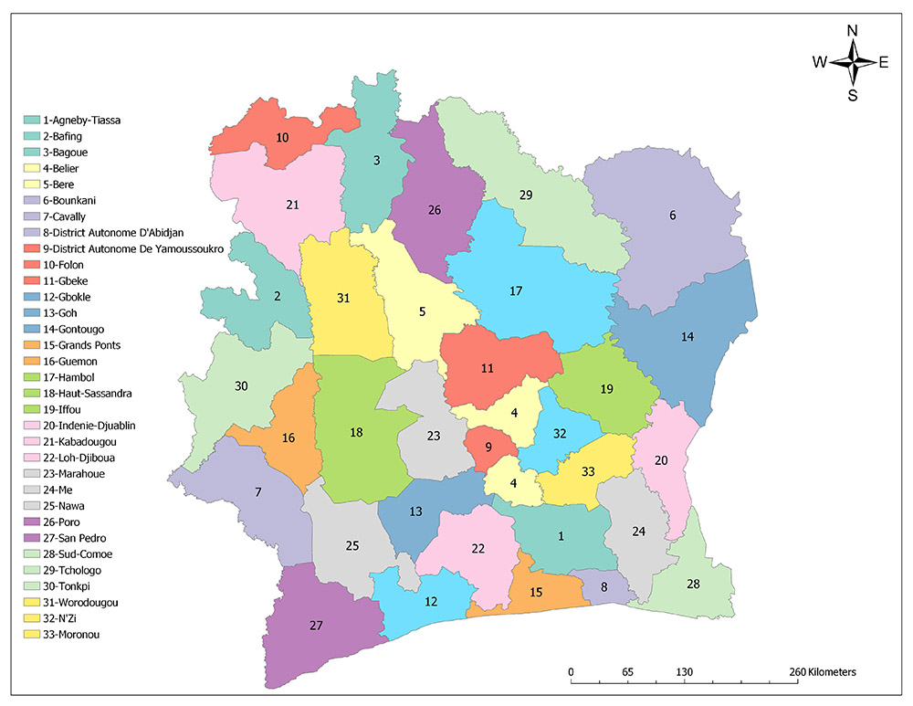
The first region was built in 1997 and the Ivory Coast was divided into 16 regions. By 2000, four regions were divided and new regions were created, increasing the number of regions to 19. By 2011, 19 regions were restructured to create 30 regions. A year later, in 2012, one region was divided and two regions were created. Thus, the number of regions on the Ivory Coast increased to 31. There are two autonomous districts in addition to 31 regions.
Thirty-One Regions of the Ivory Coast
Ivory Coast is divided into the following 31 Regions
Agnéby-Tiassa
Agnéby-Tiassa is a region in the southeast of the country. The region is adjacent to the Abidjan Autonomous District and Grands-Ponts region in the south, Moronou and Bélier in the north, Goh and Lôh-Djiboua in the west and Me region in the east. The region was created in 2011. The area of Agnéby-Tiassa region is 9,080 square kilometers and the population is 606,852 according to 2014 data.
Bafing
Bafing is a region located in the east of the country. The region is adjacent to Tonkpi in the south, Kabadougou in the north and Worodougou region in the east. The region was created in 2000. The area of the Bafing region is 8,650 square kilometers and the population is 183,047 according to the 2014 data.
Bagoué
Bagoué is a region located in the north of the country. The region is adjacent to Worodougou and Bere in the south, Poro in the east, Folon and Kabadougou region in the west. The region was created in 2011. The area of the Bagoué region is 10,668 square kilometers and the population is 375,687 according to 2014 data.
Bélier
Bélier is a region located in the central part of the country. The region is adjacent to Agnéby-Tiassa and Goh in the south, Iffou, N’zi and Moronou in the east, Yamoussoukro Autonomous District and Marahoue region in the west. The region was created in 2011. The area of Bélier region is 6,809 square kilometers and the population is 346,768 according to 2014 data.
Béré
Béré is located in the central and northern part of the country. The region is adjacent to Marahoue, Haut-Sassandra and Gbeke in the south, Hambol and San Pedro in the east and Worodougou region in the west. The region was created in 2011. The Béré region has an area of 13,293 square kilometers and a population of 389,758 according to 2014 data.
Bounkani
Bounkani is a region located in the northeastern part of the country. The region is adjacent to Gontougo and Hambol in the south and Tchologo region in the west. The region was created in 2011. The area of the Bounkani region is 22,091 square kilometers and the population is 267,167 according to 2014 data.
Cavally
Cavally is a region located in the western part of the country. The region is adjacent to San Pedro in the south, Nawa in the west, Guemon and Tonkpi region in the north. The region was created in 2011. The area of the Cavally region is 11,376 square kilometers and the population is 346,768 according to 2014 data.
Folon
Folon is a region located in the northwestern part of the country. The region is adjacent to Kabadougou in the south and Bagoué region in the west. The region was created in 2011. The area of Folon region is 11,376 square kilometers and according to the data of 7,239 the population is 96,415.
Gbêkê
Gbêkê is a region located in the central part of the country. The region is adjacent to Belier in the south, Marahoue in the west, Bere and Hambol in the north and Iffoy region in the east. The region was created in 2011. The area of Gbêkê region is 9,136 square kilometers and the population is 1,010,849 according to 2014 data.
Gbôklé
Gbôklé is a region located in the southern part of the country. The region is adjacent to Lôh-Djiboua and Nawa in the north, San Pedro in the west and Grands-Ponts region in the east. The region was created in 2011. The Gbôklé region has a surface area of 7,225 square kilometers and a population of 400,798 according to 2014 data.
Gôh
Gôh is a region located in the southern part of the country. The region is adjacent to Lôh-Djiboua in the south, Haut-Sassandra and Marahoue in the north, Nawa in the west, Yamoussoukro Autonomous District in the east, Belier and Agnéby-Tiassa region. The region was created in 2011. The Gôh region has a surface area of 7,327 square kilometers and a population of 876,117 according to 2014 data.
Gontougo
Gontougo is a region located in the eastern part of the country. The region is adjacent to Indénié-Djuablin in the south, Bounkani in the north, Hambol and Iffou region in the west. The region was created in 2011. The area of Gontougo region is 16,770 square kilometers and the population is 667,185 according to 2014 data.
Grands-Ponts
Grands-Ponts is a region located in the southern part of the country. The region is adjacent to Agnéby-Tiassa and Lôh-Djiboua in the north, Gbokle region in the west and Abidjan Autonomous District in the east. The region was created in 2011. The Grands-Ponts region has a surface area of 5,500 square kilometers and a population of 356,495 according to 2014 data.
Guémon
Guémon is a region located in the western part of the country. The region is adjacent to Nawa in the south, Tonkpi in the north, Cavally in the west and Haut-Sassandra region in the east. The region was created in 2011. The area of Guémon region is 6,695 square kilometers and the population is 919,392 according to 2014 data.
Hambol
Hambol is a region located in the northeastern part of the country. The region is adjacent to Gbeke and Iffou in the south, Poro and Tchologo in the north, Bere in the west, Cavally and Gontougo region in the east. The region was created in 2011. The area of Hambol region is 19,122 square kilometers and the population is 429,977 according to 2014 data.
Haut-Sassandra
Haut-Sassandra is a region located in the central and western part of the country. The region is adjacent to Goh and Nawa in the south, Worodougou and Bere in the north, Guemon and Tonkpi in the west, and Marahoue region in the east. The region was created in 1977. The area of the Haut-Sassandra region is 17,761 square kilometers and the population is 1,430,960 according to 2014 data.
Iffou
Iffou is a region located in the eastern part of the country. The region is adjacent to Indénié-Djuablin and Moronou in the south, Hambol in the north, Belier and Gbeke in the west and Gontougo region in the east. The region was created in 2011. The area of the Iffou region is 8,632 square kilometers and the population is 311,642 according to 2014 data.
Indénié-Djuablin
Indénié-Djuablin is an area located in the eastern part of the country. The region is adjacent to Sud-Comoé in the south, Gontougo and Iffou in the north, Moronou and La Me region in the west. The region was created in 2011. The area of the Indénié-Djuablin region is 6,919 square kilometers and the population is 560,432 according to 2014 data.
Kabadougou
Kabadougou is a region located in the northwestern part of the country. The region is adjacent to Bafing and Worodougou in the south, Folon in the north and Bagoue region in the east. Region was created in 2011. The area of Kabadougou region is 13,758 square kilometers and the population is 193,364 according to 2014 data.
La Mé
La Mé is a region located in the southeastern part of the country. The region is adjacent to the Abidjan Autonomous District and Sud-Comoe in the south, Moronou in the north, Agnéby-Tiassa in the west and Indénié-Djuablin region in the east. The region was created in 2011. The area of La Mé region is 8,237 square kilometers and the population is 514,700 according to 2014 data.
Lôh-Djiboua
Lôh-Djiboua is a region located in the southern part of the country. The region is adjacent to Gbokle and Grands Ponts in the south, Goh in the north, Nawa in the west, and Agnéby-Tiassa region in the east. The region was created in 2011. The Lôh-Djiboua region has a surface area of 10,650 square kilometers and a population of 729,169 according to 2014 data.
Marahoué
Marahoué is a region located in the central part of the country. The region is adjacent to Goh in the south, Bere in the north, Haut-Sassandra in the west, Gbeke, Belier region and Yamoussoukro Autonomous District in the east. The region was created in 1997. The area of the Marahoué region is 9,092 square kilometers and the population is 862,344 according to 2014 data.
Moronou
Moronou is a region located in the central and eastern part of the country. The region is adjacent to Agnéby-Tiassa and La Me in the south, Iffou and N’Zi in the north, Belier in the west, Indénié-Djuablin region in the east. The region was created in 2011. The area of Moronou region is 6,670 square kilometers and the population is 352,616 according to 2014 data.
Nawa
Nawa is a region located in the southwestern part of the country. The region is adjacent to Gbokle and San Pedro in the south, Guemon and Haut-Sassandra in the north, Cavally in the west, Goh and Lôh-Djiboua region in the east. The region was created in 2011. The area of Nawa region is 9,193 square kilometers and the population is 1,053,084 according to 2014 data.
N’Zi
N’Zi is a region located in the central part of the country. The region is adjacent to Moronou in the south, Yamoussoukro Autonomous District in the west and Belier region, and Iffou region in the east. The region was created in 2011. The area of the N’Zi region is 6,820 square kilometers and the population is 247,578 according to 2014 data.
Poro
Poro is a region located in the northern part of the country. The region is adjacent to Bere and Hambol in the south, Bagoue in the west and Tchologo region in the east. The region was created in 2011. The area of Poro region is 13,400 square kilometers and the population is b according to 2014 data.
San-Pédro
San-Pédro is a region located in the southwestern part of the country. The region is adjacent to Cavally and Nawa in the north and Gbokle region in the east. The region was created in 2011. San-Pédro region has a surface area of 12,790 square kilometers and a population of 826,666 according to 2014 data.
Sud-Comoé
Sud-Comoé is a region located in the southeastern part of the country. The region is adjacent to Indénié-Djuablin in the north, La Me region in the west and the Autonomous District of Abidjan. Region was created in 2011. Sud-Comoé region has a surface area of 7,189 square kilometers and a population of 642,620 according to 2014 data.
Tchologo
Tchologo is a region located in the northern part of the country. The region is adjacent to Hambol in the south, Poro in the west and Bounkani region in the east. The region was created in 2011. The area of Tchologo region is 17,728 square kilometers and the population is 467,958 according to 2014 data.
Tonkpi
Tonkpi is a region located in the western part of the country. The region is adjacent to Cavally and Guemon in the south, Bafing in the north, Haut-Sassandra and Worodougou region in the east. Region was created in 2011. The area of Tonkpi region is 12,284 square kilometers and the population is 992,564 according to 2014 data.
Worodougou
Worodougou is a region located in the northwestern part of the country. The region is adjacent to Haut-Sassandra in the south, Bagoue and Kabadougou in the north, Bafing and Tonkpi in the west, and Bere region in the east. The region was created in 1997. The area of the Worodougou region is 13,352 square kilometers and the population is 662,092 according to 2014 data.
Two Autonomous Districts of Ivory Coast
Ivory Coast is divided into 2 autonomous regions as well as 31 regions; Abidjan Autonomous District and Yamoussoukro Autonomous District.
Abidjan Autonomous District
Abidjan is the largest city and former capital of the Ivory Coast. It is known as the Paris of West Africa. Abidjan has a population of around 3 million and is one of the most populous cities in Africa. It has become a cosmopolitan center, attracting many French and neighboring citizens. Abidjan is one of the most popular cities in West Africa with its tall buildings and the lake extending to the sea. The area of Abidjan district is 2,119 square kilometers and according to 2014 data the population is 4,707,404. The population of the city is 4,395,243 according to 2014 data.
Yamoussoukro Autonomous District
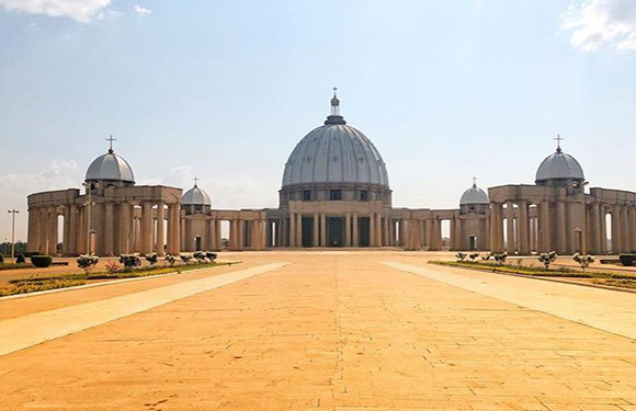
Yamoussoukro is the official capital of the Ivory Coast. Located 240 kilometers north of Abidjan, the city has an area of 3,500 square kilometers and a population of 355,573 according to 2014 data. The world’s largest basilica is located in this city. It’s seven times bigger than the Basilica in the Vatican.
Geography
Although the surface shapes of the country are generally flat, the surface of the country is mostly composed of highland and plains. Only the western parts of the country are at an altitude of 1,000 m higher than the sea level. Nimba Mountain, which has a height of 1.752 m, is located near the Guinea border of the country’s highest point. Part of the northern part of the country is located within the formation called the Upper Guinea Highlands. In addition, the average height is between 200 m and 350 m.
Governance
Côte d’Ivoire is a republic managed by the constitution. The current constitution was ratified by the referendum on 23 July 2000 and entered into force. The country has a multi-party political system and is governed by the presidential system. The head of the Côte d’Ivoire is at the top of the state and is also the Commander-in-Chief of the armed forces of Côte d’Ivoire. The president of Côte d’Ivoire is elected for a five-year period and the elected president has the right to be elected to this post for a maximum of two consecutive terms.
The prime minister, the head of state, is appointed as the head of the government and can be dismissed by the same presidency. Where the head of the Côte d’Ivoire is not in the country, the prime minister who has served in this capacity is not obliged to be elected from the party which has a majority in the parliament.
Climate
The coastal regions are tropical and the northern regions are under the influence of the semi-continental climate. Three seasons are experienced. November – March temperate and dry, March-May hot and dry, June – October is hot and humid.
Religion
Islam is the most common religion throughout the country and 40.2% of the population lives according to the Islamic beliefs. The second most common religion is the Christian religion with 38.7%. In this ratio, the rate of the Christians of the Catholic sect is 19.3% and 19.3% of the protestant sects. Except for these two religions, according to 2011-2012 data, there is a small group that declares that they do not belong to any religion other than those who believe in local African religions.
Industry and Tourism
Ivory Coast is the world’s leading manufacturer and exporter of coffee, cocoa beans, and palm oil. The economy, therefore, fluctuates according to the fluctuations in the world market and weather conditions. 68% of the country’s population is employed in the agricultural sector. The most important agricultural products are coffee, cocoa, banana, palm extract, corn, rice, cassava, potatoes, sugar, cotton, rubber, and timber. Cocoa is the leading product in export with 33%. Other major export products are tropical wood, oil, cotton, banana, palm oil, and fish. France, USA, Netherlands, and Nigeria are the most important export partners. Food, consumer goods, investment goods, fuel, and transportation vehicles are imported. France, Nigeria, and Singapore are the biggest import partners.
Image Sources and Copyright Information
- Colorful Political Map of Côte d’Ivoire (Ivory Coast) Showing Regions and Major Cities: © Rainer Lesniewski/Shutterstock