Brunei is located in the Southeastern Asia region at latitude 4.535277 and longitude 114.727669 and is part of the Asian continent continent.
The DMS coordinates for the center of the country are:
4° 32' 7.00'' N
114° 43' 39.61'' E
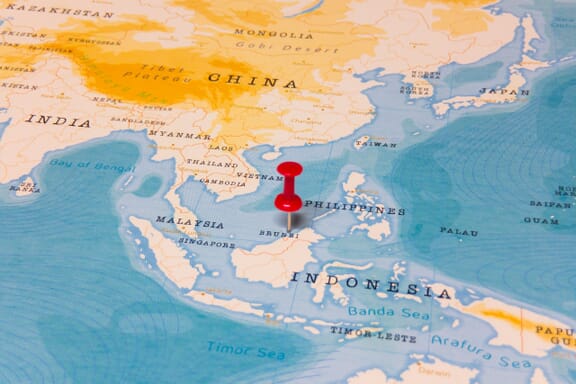
You can see the location of Brunei on the world map below:
Brunei on the World Map
Brunei Neighboring Countries
The neighboring countries of Brunei (BN) are:
- Malaysia (MY)
Maritime Borders
Brunei borders with the South China Sea.
Brunei Key Facts
| Country | Brunei |
|---|---|
| Coordinates |
Latitude: 4.535277 Longitude: 114.727669 |
| Country Codes |
Alpha 2: BN Alpha 3: BRN |
| Country Flag Emoji | 🇧🇳 |
| Int. Phone Prefix | +673 |
| Capital city | Bandar Seri Begawan |
| Continent / Subcontinent |
Asia Southeastern Asia |
| Country Area | 5,765 sq km |
| Population 2024 |
462,721 World Rank: 173 |
| Median Age | 31.8 |
| Life expectancy | 75.3 |
| Major languages | Malay (Bahasa Melayu) (official), English, Chinese dialects |
| UTC/GMT Time |
Number of time zones: 1
|
| Internet TLD | .bn |
| Biggest Airport | Brunei International Airport (Bandar Seri Begawan) |
| Average temperature |
26.85 °C 80.33 °F |
| Administrative Divisions | 4 districts |
| Political system | Absolute monarchy |
Brunei Economy Facts
| World Bank Income Group | High income |
|---|---|
| World Bank Region | East Asia & Pacific |
| Currency | Brunei Dollar (BND) |
| GDP in 2024 |
$15.3 (billions of USD) World Rank: 142 |
| GDP per capita in 2024 |
$33,153 World Rank: 49 |
| Major Industries / Economic Sectors | Oil and gas, manufacturing, agriculture, tourism |
| Top 5 Import Countries | Malaysia, Singapore, China, United States, Japan |
| Top 5 Export Countries | Japan, South Korea, China, Australia, United States |
Biggest Cities in Brunei
Here are the largest cities in Brunei based on 2024 data:
| City | Population |
|---|---|
| Bandar Seri Begawan | 64,409 |
| Sengkurong | 40,972 |
| Mentiri | 39,324 |
| Kuala Belait | 31,178 |
| Seria | 30,097 |
| Tutong | 19,151 |
| Serasa | 18,569 |
| Liang | 16,813 |