Brunei is situated on the northwest of the island of Borneo in the South China Sea. It is a part of Oceania and is a sandstone, shale, and clay island with hilly lowlands, rugged mountain terrain, and a vast tidal or swampy plain along the coast.
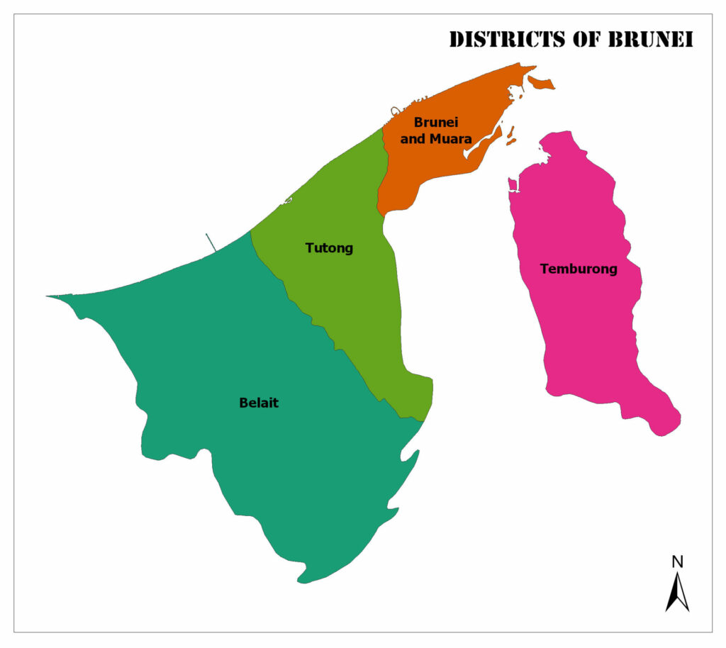
Below, you can see the districts of Brunei map:
The climate is equatorial with high humidity, heavy rainfall, and high temperatures. The history of Brunei ties back to a sultanate dynasty in the 14th to 16th centuries before being beset by war, piracy, and colonization.
A British protectorate since the middle of the nineteenth century, Brunei asserted full internal independence in 1971, and in 1967 the current sultan took his place as Prime Minister.
We’ll talk about the different Brunei disctricts and feature a few famous or beautiful places to see when you are traveling to these districts.
Brunei and Muara
The smallest district in landmass is also the most populated in Brunei. The capital of Bandar Seri Begawan is just over 16 square kilometers, and a few famous tourist spots are located within the flourishing city.
It is one of the oldest cities in Brunei and is often one of the most visited Brunei districts. Another old city is the town of Muara, about 41 kilometers northeast of the capital, where the chief port is located. This is perfect for beach lovers and sailors.
There are also small islands off the east coast of this district and a bay located just south of the capital with beautiful nature and water sports. This region’s climate is humid tropical on the coast and humid subtropical inland.
Water Village of Brunei (Kampong Ayer)
Located on stilts over the Brunei River, Kampong Ayer is known as the Venice of the East. With bright colored houses, mosques, and schools, it is a truly unique 10 square kilometer neighborhood of the capital city.
The old capital of the Bruneian Empire, this flourishing and iconic city is a draw for tourists and Bruneian from across the globe.
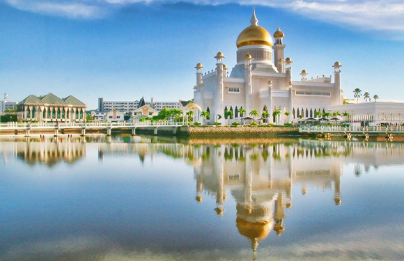
Omar Ali Saifuddien Mosque
Located in the capital city, this is one of the country’s two national mosques and a significant historical landmark. It is named after the current Sultan’s father and is the largest and oldest mosque in the country of Brunei.
With a brilliant golden dome and taking almost five years to construct, the architecture is influenced by Mughal architecture, much like the famed Taj Mahal in India. It can accommodate 3,000 worshipers, and the height of the dome is 171 feet.
Temburong
A humid subtropical higher altitude Brunei district east of the others, it is separated from the bulk of Brunei by Malaysia. It is not as populated as the other districts, comprising only 10% of the total population of Brunei.
It comprises rugged mountains and a tropical coastal region in the north as well. Called an exclave because it is a piece of land separated by another country, Temburong district is accessible via a bridge and is just across the bay from the capital city.
It is primarily a vacation district for locals hosting the country’s first national park and scientific research facility to study the rainforests of Oceania. It is a famous district for eco-tourism and outdoor experiences like hiking.
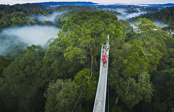
Ulu Temburong National Park
This national park is located in the south and is the first national park in Brunei. It is also part of a joint research center known as the Kuala Belalong Rainforest Field Studies Center. It is only accessible by boat, and part of it is allocated for something called the Celalong Rainforest Experience.
For nature lovers and interested learners, this facility works with the Smithsonian Tropical Research Institute to promote ways to save tropical plants and animal species.
Tutong
If you check a Brunei districts map, you’ll see that Tuton is immediately west of the capital district and makes up the heart of the mainland of the country. Its administrative capital Pekan Tutong is surrounded by rolling hills and rainforests.
The city is known for its religious tradition and education, hosting a school that is not administered by the Ministry of Education but the Ministry of Religious Affairs. It is dedicated to the Arabic-medium Islamic religious teachings.
The district is also known for its coastline and hosting the largest natural lake in Brunei, known as Tasek Merimbun. There is a river that only flows through Tutong and it is called Tutong River, which empties into the South China Sea in the north of the district.
Also Read: Brunei Flag Map and Meaning
Tasek Merimbun and Surrounding Park
Containing the largest natural lake in Brunei, this ASEAN Heritage Park is important for its natural wildlife and ecosystem. The S-shaped lake is located less than 30 kilometers from the district capital Tutong town and is surrounded by the Tasek Merimbun Heritage Park.
This lake is iconically very dark in color and hosts two islands. It is possible to hire a small boat to take you across the lake or explore the islands, and there is also a small island reachable by a wooden walkway. There are facilities for picnics hiking, and you might even see the protected local species- Storm’s storks.
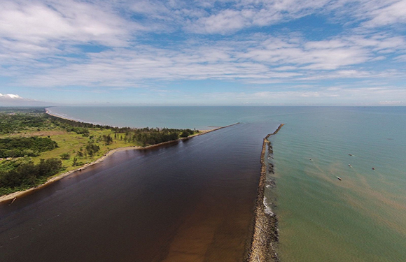
Pantai Seri Kenangan
This beach is simply named “unforgettable beach,” and that is an understatement. This popular recreational area is magical because of the effect created by a narrow spit of land separating the South China Sea from the clear blue Tutong River.
There are so many coconut palms and a beautiful bridge and ferry in this area that it is popular with locals and tourists alike. There are restaurants, playgrounds, a large beach, and food stalls available for anyone to use.
Belait
The largest and farthest west district of Brunei, it is commonly associated with the gas and oil industry. This is all focused near the city of Seria on the coast, which is also flanked by the Belait River. Covering half the area of the entire nation, Belait is full of peat swamps and lowland forests near the coast.
It also has a rainforest in the interior and is home to the Belait Swamp Forest, which is protected as an Important Avian Area. These Brunei districts are associated with the industry for several reasons, including their ties to oil and gas companies like Shell.
This area is covered in forest and swamps which makes the population centers close to the coast and Belait River. Though it is the largest district, it is not as populated as the smaller capital district in the northeast. Mostly composed of urban dwellers, this district has a few natural beauties including a tropical coastline and national park.
Belait Swamp Forest
This protected forested land in Belait contains a mix of peat swamp, rainforest, and tropical heath forest. It is home to endangered and threatened bird species. A few of these species include the black partridge, large green pigeons, Storm’s storks, and large-billed blue-flycatchers.
This conserved swampland and the tropical forest are under threat due to pipeline and road construction but also the ever-present threat of wildfire. Full of natural beauty, this palace is navigable by local experts or tour guides and is full of natural wonders and singing birds.


