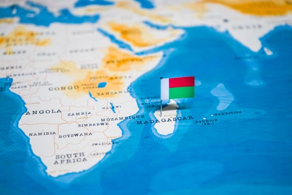
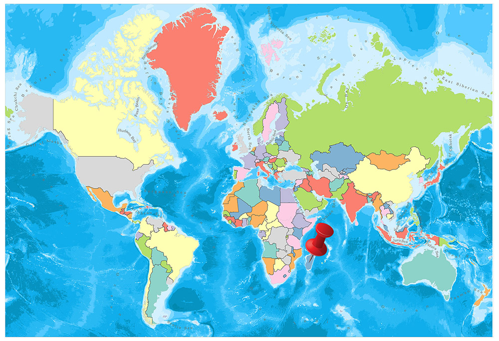
Madagascar is located in the Southern Africa region at latitude -18.766947 and longitude 46.869107 and is part of the African continent.
The DMS coordinates for the center of the country are:
- 18° 46' 1.01'' S
- 46° 52' 8.79'' E
You can see the location of Madagascar on the world map below:
The country has no neighboring countries/land borders.
Maritime Borders
Madagascar borders with the Indian Ocean.
Madagascar Related Content
Madagascar Key Facts
| Country | Madagascar |
| Coordinates | Latitude: -18.766947 Longitude: 46.869107 |
| Country Codes | Alpha 2: MG Alpha 3: MDG |
| Country Flag Emoji | 🇲🇬 |
| Int. Phone Prefix | +261 |
| Capital city | Antananarivo |
| Continent Subcontinent | Africa Southern Africa |
| Country Area | 587,041 sq km |
| Population 2021 | 28,427,333 World Rank: 51 |
| Median Age | 19 |
| Life expectancy | 64.5 |
| Major languages | French (official), Malagasy (official), English |
| UTC/GMT Time | Number of time zones: 1
|
| Internet TLD | .mg |
| Biggest Airport | Ivato International Airport (TNR) |
| Average temperature | 22.65 °C 72.77 °F |
| Administrative Divisions | 6 provinces |
| Political system | Presidential representative democratic republic |
Madagascar Economy Facts
| World Bank Income Group | Low income |
| World Bank Region | Sub-Saharan Africa |
| Currency | Malagasy Ariary (MGA) |
| GDP in 2020 | $13.2 (billions of USD) World Rank: 134 |
| GDP per capita in 2020 | $478 World Rank: 192 |
| Major Industries / Economic Sectors | Agriculture, manufacturing, energy, services |
| Top 5 Import Countries | China, India, France, United Arab Emirates, Saudi Arabia |
| Top 5 Export Countries | China, India, United States, France, Indonesia |
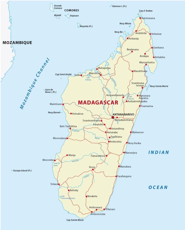
Biggest Cities in Madagascar
Here are the largest cities in Madagascar based on 2021 data:
| City | Population |
|---|
| Antananarivo | 2,610,000 | Antsirabe | 257,163 | Toamasina | 225,116 | Fianarantsoa | 184,184 | Mahajanga | 154,657 | Toliara | 115,319 | Antsiranana | 82,937 | Tolanaro | 67,284 | Antalaha | 47,224 | Sambava | 43,465 |
Map of Madagascar with the Largest Cities
Other Countries in the Southern Africa Region
- Where are the Seychelles?
- Where is Angola?
- Where is Botswana?
- Where is Burundi?
- Where is Eswatini (formerly named Swaziland)?
- Where is Kenya?
- Where is Lesotho?
- Where is Malawi?
- Where is Mauritius?
- Where is Mozambique?
- Where is Namibia?
- Where is Rwanda?
- Where is South Africa?
- Where is South Sudan?
- Where is the Congo?
- Where is Uganda?
- Where is Zambia?
- Where is Zimbabwe?
Political Map & Regions of Madagascar
Political Map of Madagascar
Geography
Madagascar, the fourth-largest island in the world, is 1,570 km long from north to south and has a maximum width of 575 kilometers.
The coastline with more than about 4,800 km, the change of its geographical structure with the mountain chain extending along its entire length is remarkable.
The island is divided into three natural areas of the geography: the mountainous inner region, the east coast and the west coast.
The mountainous inner region, named after the high plateaus, has an altitude of 900 to 1,500 m above sea level and contains three mountain ranges with a height exceeding 1,830 m.
The highest peak is Maromokotro (2,876 m), on the northern Tsratanna mountain range. The surfaces of the plateaus have different characteristics. All directions include cross valleys and deep streams. In the high parts of the mountainous region, there are large low pressure areas and marshy plains.
The east coast, which has an average of 50 km, is located between the high plateaus and the Indian Ocean. It is characterized by erosion hills and marshes. As the only indentation, the coastline including the Antongil Bay is parallel to the main axis of the mountains. The rivers pouring from this shore into the Indian Ocean are short but suitable for short distances.
The western coast, which has reached 190 km in some places, has a more variable, more indented appearance than the east coast with its plains depressions and plateaus. This is the most important geographical feature of Madagascar. The rivers poured into the Mozambique Channel are longer and have large sections.
Governance
In the Democratic Republic of Madagascar announced on 30 December 1975, the President is elected for seven years. The President presides over the 12-member Council of the Revolution. The Prime Minister shall be appointed by the President. There is only one party in the country where the National People’s Assembly has been in office for six years. Madagascar is a member of the United Nations and the African Union.
Climate
On the island, climate changes depend on altitude differences rather than latitude differences. The climate is generally hot and humid. The mountainous interior is mild.
There are two seasons in Madagascar: Hot (rainy) season and cold (dry) season. Hot season is the period of daily rains and storms. This season continues in the high plateaus from the end of November until the end of April. The east coast lasts longer, is shorter on the west coast. It takes only two months to the south (range and quarry). The cold season continues from April to November. In this season, the east coast and north west are rainy and high plateaus are humid.
The west coast is arid, the southern coast is even more dry. Annual average precipitation varies by region. The rainfall on the coast of Antongil, which is 3,700 mm, is 2,100 millimeters on the northwest coast, 940 millimeters in the west and 355 kilometers in the southwest. This amount varies between 1,200-1,325 mm in the inner plateau. The average annual temperature is 21 ° C-27 ° C on the coast and 13 ° -19 ° C on the inner plateau. The coldest month is July.
Religion
About one third of the population of Madagascar is Christian. Christianity has spread throughout the country by the missionaries in the nineteenth century. There are several hundred thousand Muslims in Madagascar, especially in the northwest. Most of the people in the countryside continue their old religions.
Industry and Tourism
Until recently, the economy of Madagascar was under the control of French economic organizations. Today, with an accelerated nationalization policy, the government has nationalized 35% of the industry, 78% of exports, 60% of imports, and banking and insurance as a whole.
Priority in the economy is given to agriculture where more than 80% of the population is engaged. Agricultural products such as tobacco, vanilla, tea, cloves, peppers and coffee grown in the country are exported. Rice, the main foodstuff of the people, is grown, but for the people of the city, more than 100 thousand tons of rice is imported annually. 10 million cattle raised in Madagascar allow the country to export frozen meat. Agricultural products provide 30% of export revenues. Chromium, mica, graphite and second grade precious stones are exported.
Madagascar is expected to become an oil exporting country thanks to large oil reserves discovered in recent years. Most of the products are imported, but due to a strict import policy, the trade balance is shifting in favor of the country. Inflation is around 8%.
Arts
Different ethnic groups living in Madagascar live according to their beliefs. The core cultural traits that are common across the island are the identity of a powerful and unified Madagascar culture. There is a common language. The values that emphasize the traditional Madagascar worldview are called fihavanana (solidarity), vintana (destiny), tody (karma) and hasina (sacred life force). Music is one of the most important cultural ways of expressing itself throughout the country. The music range in Madagascar ranges from traditional folk music to the so-called halk salegi elp in coastal areas.
Regions of Madagascar
The African island country, Madagascar, is divided into 22 regions. According to the proposal, which was adopted as a result of the referendum on 4 April 2007, Madagascar, which had an administrative structure previously separated by six, created 22 regions as a result of this law and the new administrative structuring scheme was started as of October 2009.
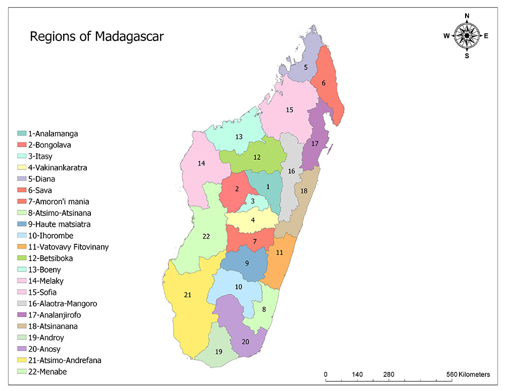
Twenty-Two Regions of Madagascar
Madagascar is divided into 22 regions as the highest administrative division. These regions are Analamanga, Bongolava, Itasy, Vakinankaratra, Diana, Sava, Amoron Mania, Atsimo-Atsinana, Haute Matsiatra, Ihorombe, Vatovavy Fitovinany, Betsiboka, Boeny, Melaky, Sofia, Alaotra-Mangoro, Analanjirofo, Atsinanana, Androy, Anosy, Atsimo -Andrefana and Menabe.
Analamanga
Analamanga is a region in the center of Madagascar, which includes the capital Antananarivo and the surrounding metropolitan area. The region has an area of 16,911 square kilometers and in 2013 the estimated population is 3,348,794. The population density of the region is 200 / square kilometers. The region extends to the north of the capital. Region was formed by the division of Antananarivo Province in 2009 with the study. The region is subdivided into eight districts and 134 communes in these eight districts.
Bongolava
Bongolava is a region located in mid-western Madagascar. The capital of the region is Tsiroanomandidy. The region has an area of 16,688 square kilometers and in 2013 the estimated population is 457,368. The population density of the region is 27 / square kilometers. Region was formed by the division of Antananarivo Province in 2009 with the study. The region is subdivided into two districts and 24 communes.
Itasy
Itasy is a region located in central Madagascar. The capital of the region is Miarinarivo. The region has an area of 6,993 square kilometers and the estimated population in 2013 is 732,834. The population density of the region is 105 / square km. In 2009, it was formed by the division of the Antananarivo Province. The region is subdivided into three districts and 51 communes in these three districts.
Vakinankaratra
Vakinankaratra is a region in central Madagascar. The capital of the region is Antsirabe. The region has an area of 16,599 square kilometers and in 2013 the estimated population is 1,803,307. The population density of the region is 109 / square km. It was formed in 2009 with the division of Antananarivo Province. The region is divided into seven districts as sub-districts and 86 communes in these seven districts.
Diana
Diana is a region located in the northernmost Madagascar. The capital of the region is Antsiranana. The region has an area of 19,266 square kilometers and the estimated population in 2013 is 700,021. The population density of the region is 36 / sq. Km. Region was formed by the division of Antsiranana Province in 2009. The region is divided into five districts as sub-districts and 51 communes in these five districts.
Sava
Sava is a region in northern Madagascar. The capital of the region is Sambava. The region has an area of 25,518 square kilometers and in 2013 the estimated population is 980,807. The population density of the region is 34 / square km. Region was formed by the division of Antsiranana Province in 2009. The region is divided into four districts as sub-districts and 75 communes in these four districts.
Amoron’i Mania
Amoron Mania is a region in central Madagascar. The capital of the region is the city of Ambositra. The region has an area of 16,141 square kilometers and the estimated population in 2013 is 715,027. The population density of the region is 44 / sq. Km. Region was formed by the division of Fianarantsoa Province in 2009. The region is divided into four districts as sub-regions and 53 communes in these four districts.
Atsimo-Atsinanana
Atsimo-Atsinanana is a region in southeastern Madagascar. Farafangana is the capital of the region. The area has an area of 18,863 square kilometers and in 2013 the estimated population is 898,702. The population density of the region is 48 / square km. Region was formed by the division of Fianarantsoa Province in 2009. The region is subdivided into five districts and 90 communes in these five districts.
Haute Matsiatra
Haute Matsiatra is a region located in central Madagascar. The capital of the region is Fianarantsoa. The region has an area of 21,080 square kilometers and in 2013 the estimated population is 1,199,183. The population density of the region is 57 / square kilometers. Region was formed by the division of Fianarantsoa Province in 2009. The region is divided into seven districts as the sub-region and 76 communes in these seven districts.
Ihorombe
Ihorombe is a region located in mid-south Madagascar. The capital of the region is Ihosy. The region has an area of 26,391 square kilometers and in 2013 the estimated population is 312,307. The population density of the region is 12 / sq. Km. Region was formed by the division of Fianarantsoa Province in 2009. The region is subdivided into three districts and 24 communes in these three districts.
Vatovavy Fitovinany
Vatovavy Fitovinany is a region in southeastern Madagascar. The capital of the region is Manakara. The region has an area of 19,605 square kilometers and in 2013 the estimated population is 1,416,459. The population density of the region is 72 / square kilometers. Region was formed by the division of Fianarantsoa Province in 2009. The region is divided into six districts as sub-region and 122 communes in these three districts.
Betsiboka
Betsiboka is a region located in mid-north Madagascar. The capital of the region is Maevatanana. The region has an area of 30,025 square kilometers and in 2013 the estimated population is 293,522. The population density of the region is 10 / sq. Km. The region was formed by the division of Mahajanga Province in 2009. The region is subdivided into three districts and 36 communes in these three districts.
Boeny
Boeny is a region in northwestern Madagascar. The capital of the region is Mahajanga city. The region has an area of 31,046 square kilometers and its estimated population in 2013 is 799,675. The population density of the region is 26 / sq. Km. The region was formed by the division of Mahajanga Province in 2009. The region is subdivided into six districts and this is divided into 43 communes in six districts.
Melaky
Melaky is a region in northwestern Madagascar. The capital of the region is Maintirano. The region has an area of 38,852 square kilometers and in 2013 the estimated population is 289,594. The population density of the region is 8 / square km. The region was formed by the division of Mahajanga Province in 2009. The region is divided into five districts as the sub-region and 32 communes in these five districts.
Sofia
Sofia is a region in northern Madagascar. The capital of the region is Antsohihy. The region has an area of 50,100 square kilometers and in 2013 the estimated population is 1,247,037. The population density of the region is 25 / sq. Km. The region was formed by the division of Mahajanga Province in 2009. The region is divided into seven districts as sub-regions and 108 communes in these seven districts.
Alaotra-Mangoro
Alaotra-Mangoro is a region in northern Madagascar. The capital of the region is the city of Ambatondrazaka. The region has an area of 31,948 square kilometers and in 2013 the estimated population is 1,027,110. The population density of the region is 32 / square km. Region was formed by the division of Toamasina Province in 2009. The region is subdivided into five districts and in these five districts is divided into 79 communes.
Analanjirofo
Analanjirofo is a region in northeastern Madagascar. The capital of the region is Fenoarivo Atsinanana. The region has an area of 21,930 square kilometers and in 2013 the estimated population is 1,035,132. The population density of the region is 47 / sq. Km. Region was formed by the division of Toamasina Province in 2009. The region is subdivided into six districts and divided into 63 communes in this six district.
Atsinanana
Atsinanana is a region in eastern Madagascar. The capital of the region is the city of Toamasina. The region has an area of 21,934 square kilometers and the estimated population in 2013 is 1,270,680. The population density of the region is 58 / sq. Km. Region was formed by the division of Toamasina Province in 2009. The region is divided into seven districts as sub-regions and 82 communes in these seven districts.
Androy
Androy is a region in the southernmost Madagascar. The capital of the region is Ambovombe-Androy. The region has an area of 19,317 square kilometers and in 2013 the estimated population is 733,933. The population density of the region is 38 / square kilometers. Region was formed by the division of Toliara Province in 2009. The region is subdivided into four districts and 51 communes in these four districts.
Anosy
Anosy is a region in southern Madagascar. The capital of the region is Tôlanaro. The region has an area of 25,731 square kilometers and in 2013 the estimated population is 671,805. The population density of the region is 26 / sq. Km. Region was formed by the division of Toliara Province in 2009. The region is divided into three districts as sub-regions and 64 communes in these three districts.
Atsimo-Andrefana
Anosy is a region in southern Madagascar. The capital of the region is Tôlanaro. The region has an area of 25,731 square kilometers and in 2013 the estimated population is 671,805. The population density of the region is 26 / sq. Km. Region was formed by the division of Toliara Province in 2009. The region is divided into three districts as sub-regions and 64 communes in these three districts.
Menabe
Menabe is a region in western Madagascar. The capital of the region is Morondava. The area has an area of 46,121 square kilometers and the estimated population in 2013 is 592,113. The population density of the region is 13 / sq. Km. Region was formed by the division of Toliara Province in 2009. The region is divided into five districts as sub-districts and 51 communes in these five districts.
Image Sources and Copyright Information
- Madagascar Flag Pin on Map: © hyotographics/Shutterstock