Kiribati is located in the Australia and Oceania region at latitude -3.370417 and longitude -168.734039 and is part of the Oceania continent continent.
The DMS coordinates for the center of the country are:
3° 22' 13.50'' S
168° 44' 2.54'' W
You can see the location of Kiribati on the world map below:
Kiribati on the World Map
Kiribati Neighboring Countries
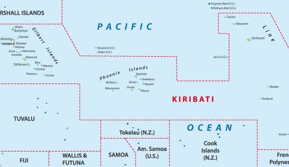
The country has no neighboring countries/land borders.
Maritime Borders
Kiribati borders with the Pacific Ocean.
Kiribati Key Facts
| Country | Kiribati |
|---|---|
| Coordinates |
Latitude: -3.370417 Longitude: -168.734039 |
| Country Codes |
Alpha 2: KI Alpha 3: KIR |
| Country Flag Emoji | 🇰🇮 |
| Int. Phone Prefix | +686 |
| Capital city | Tarawa |
| Continent / Subcontinent |
Oceania Australia and Oceania |
| Country Area | 811 sq km |
| Population 2024 |
134,518 World Rank: 187 |
| Median Age | 21.9 |
| Life expectancy | 66.5 |
| Major languages | I-Kiribati, English (official) |
| UTC/GMT Time |
Number of time zones: 3
|
| Internet TLD | .ki |
| Biggest Airport | Bonriki International Airport (TRW) |
| Average temperature |
28.20 °C 82.76 °F |
| Administrative Divisions | 3 groups of islands |
| Political system | Parliamentary democracy |
Kiribati Economy Facts
| World Bank Income Group | Lower middle income |
|---|---|
| World Bank Region | East Asia & Pacific |
| Currency | Australian Dollar (AUD) |
| GDP in 2020 |
$0.2 (billions of USD) World Rank: 207 |
| GDP per capita in 2020 |
$2,289 World Rank: 170 |
| Major Industries / Economic Sectors | Agriculture, fishing, manufacturing, tourism |
| Top 5 Import Countries | Australia, Fiji, United States, New Zealand, China |
| Top 5 Export Countries | Australia, United States, China, Fiji, New Zealand |
Biggest Cities in Kiribati
Here are the largest cities in Kiribati based on 2024 data:
| City | Population |
|---|---|
| Tarawa | 40,311 |


