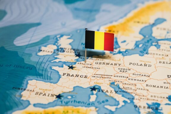
Belgium is located in the Western Europe region at latitude 50.503887 and longitude 4.469936 and is part of the European continent.
The DMS coordinates for the center of the country are:
- 50° 30' 13.99'' N
- 4° 28' 11.77'' E
You can see the location of Belgium on the world map below:
Belgium Neighboring Countries
The neighboring countries of Belgium (BE) are:
- France (FR)
- Germany (DE)
- Luxembourg (LU)
- Netherlands (NL)
Maritime Borders
Belgium borders with the North Sea.
Belgium Related Content
Belgium Key Facts
| Country | Belgium |
| Coordinates | Latitude: 50.503887 Longitude: 4.469936 |
| Country Codes | Alpha 2: BE Alpha 3: BEL |
| Country Flag Emoji | 🇧🇪 |
| Int. Phone Prefix | +32 |
| Capital city | Brussels |
| Continent Subcontinent | Europe Western Europe |
| Country Area | 30,528 sq km |
| Population 2024 | 11,858,610 World Rank: 81 |
| Median Age | 40.9 |
| Life expectancy | 82.4 |
| Major languages | Dutch (official) 60%, French (official) 40%, German (official) less than 1% |
| UTC/GMT Time | Number of time zones: 1
|
| Internet TLD | .be |
| Biggest Airport | Brussels Airport (BRU) |
| Average temperature | 9.55 °C 49.19 °F |
| Administrative Divisions | 3 regions 10 provinces |
| Political system | Federal parliamentary democracy |
Belgium Economy Facts
| World Bank Income Group | High income |
| World Bank Region | Europe & Central Asia |
| Currency | Euro (EUR) |
| GDP in 2024 | $671.4 (billions of USD) World Rank: 22 |
| GDP per capita in 2024 | $56,615 World Rank: 24 |
| Major Industries / Economic Sectors | Manufacturing, services, agriculture, energy |
| Top 5 Import Countries | Germany, Netherlands, France, United Kingdom, United States |
| Top 5 Export Countries | Germany, Netherlands, France, United Kingdom, United States |
Biggest Cities in Belgium
Here are the largest cities in Belgium based on 2024 data:
| City | Population |
|---|
| Brussels | 1,019,022 | Antwerp | 529,247 | Gent | 265,086 | Charleroi | 200,132 | Liege | 195,278 | Anderlecht | 160,553 | Schaerbeek | 132,761 | Bruges | 118,509 | Namur | 110,939 | Leuven | 101,032 |
Map of Belgium with the Largest Cities
Other Countries in the Western Europe Region
Beer, waffles, french fries, architecture, multiculturalism, and countless other reasons to visit Belgium are why millions of tourists visit the country every year. But can most non-Europeans point to this small European country on a map?
We’ll take a look at a political map of Belgium in this post to see which countries are its neighbors, where its major cities are, and even see some of the water features in the country. We’ll also learn more about the country’s history, geography, culture, and population.
Where is Belgium?
Belgium is one of the smaller countries in Western Europe, located between the Netherlands, Germany, Luxembourg, and France. It also has a coastline on the North Sea opposite the island of Great Britain. Despite its relatively small size, Belgium’s location gives it an important economic role in Europe.
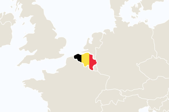
In the above map, the colors of the flag of Belgium show the country’s location in Northwestern Europe. It shares borders with four different countries and the sea. Its longest international border is shared with France, and its shortest foreign border separates the country from Luxembourg.
Let’s take a closer look at the country in this political map of Belgium:
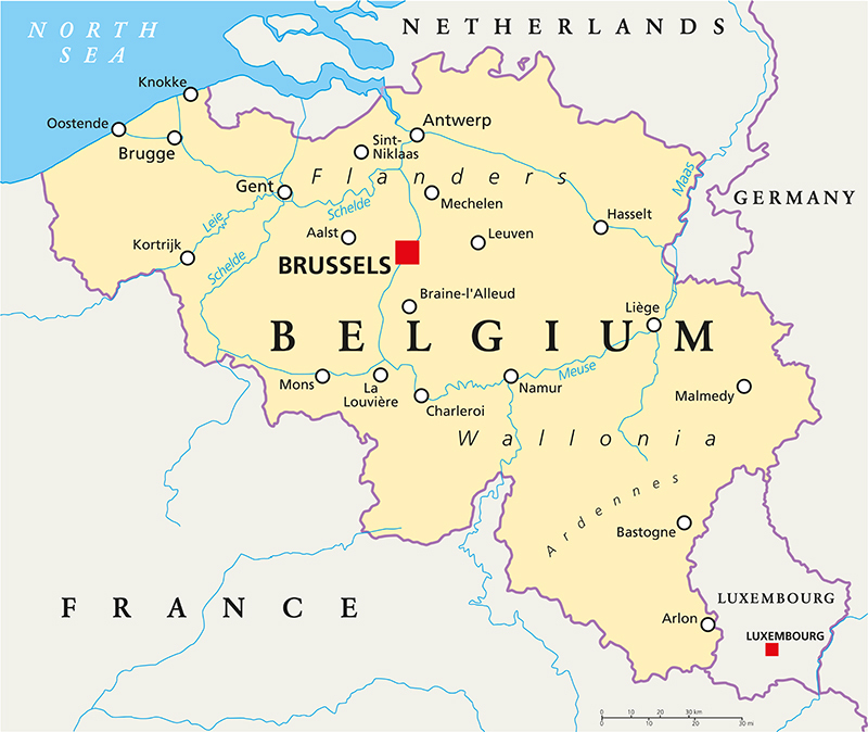
On this map, Brussels, the capital of Belgium, can be seen near the center of the country. Also depicted are major rivers, cities, and detailed national borders.
Regions of Belgium
There are three main regions of Belgium: Flanders, Wallonia, and the Brussels Capital Region, all three of which can be seen on the map below.
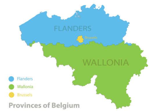
While Brussels enjoys special status as the country’s capital and is neither a province nor divided into provinces, Flanders and Wallonia are each divided into several provinces, which are further divided into many municipalities. Wallonia is the largest region in Belgium, covering about 55% of the country’s territory, and Flanders is the most populous.

As detailed in the map above, the regions of Flanders and Wallonia are each divided into five provinces. Most of these take their names from duchies or counties in similar locations. There are 43 arrondissements in Belgium.
Major Cities
Brussels
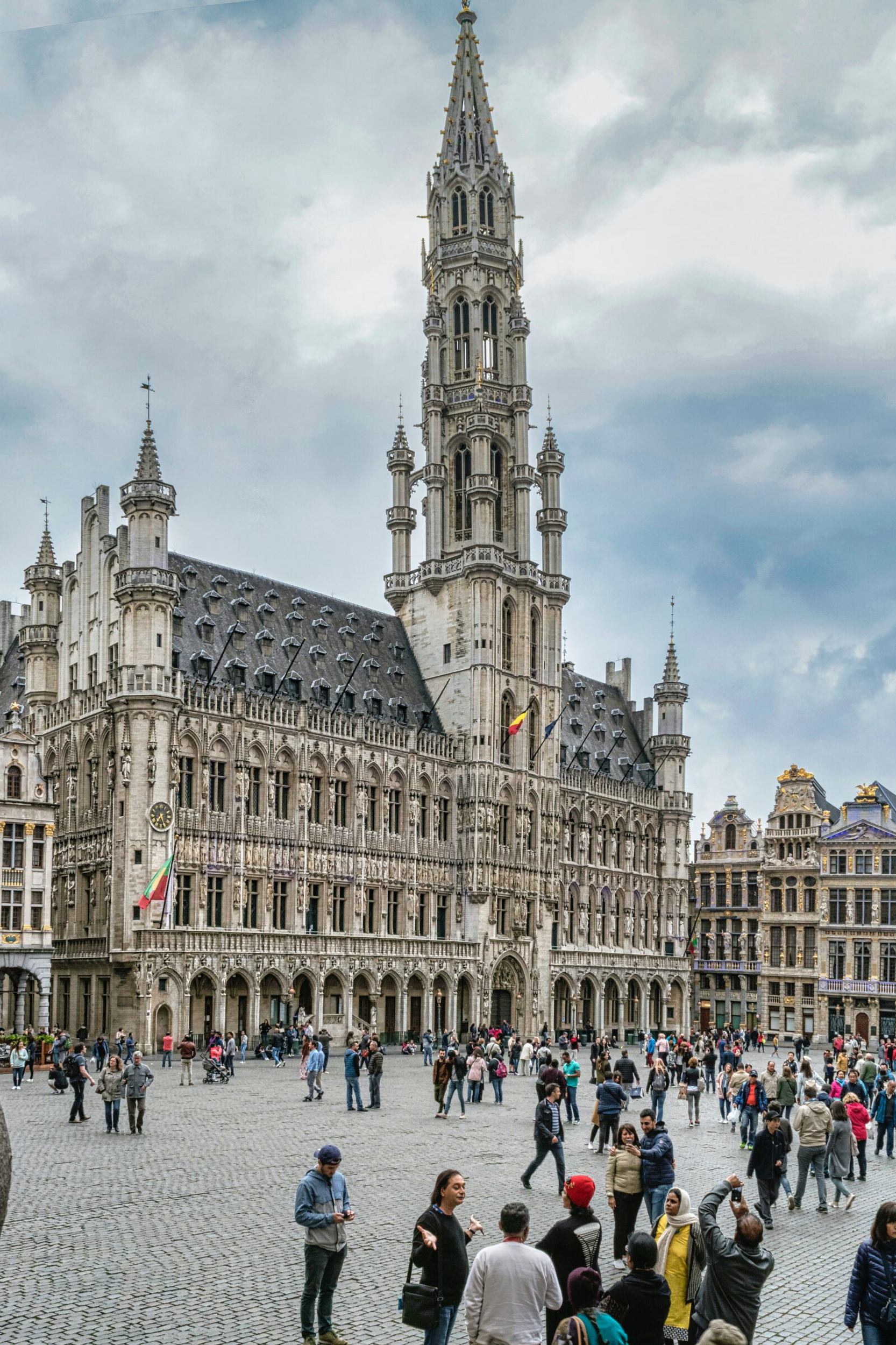
The capital city of Belgium is not only a major city in the country, but also on the continent. Brussels is the administrative center of the European Union, hosting several important EU institutions. It’s even referred to as the “capital of Europe.”
In addition to its importance within the EU, Brussels is best known for its cuisine, architectural landmarks, and its multicultural identity. Waffles, chocolate, and beer are some of the gastronomical offerings most associated with the city, and it is home to many high-quality restaurants.
Perhaps the most striking example of architectural beauty in Brussels is at the city’s Grand Place, which has been a UNESCO Word Heritage Site since 1998. This plaza boasts an incredible Town Hall building and its famous guild houses.
Antwerp

While it isn’t the nation’s capital, Antwerp is Belgium’s largest city by area and has the largest city-center population. The city is linked to the North Sea by the River Scheldt and has the second-largest port in Europe. It’s also the largest center for diamond trade in the world. Antwerp brings in the largest portion of Belgium’s GDP.
Antwerp also has a reputation as an artistic city; its famous painting school, School of Antwerp, produced several notable artists in the 17th century. Music is another important element of Antwerp’s cultural scene. There are multiple music festivals that take place in the city, and it is the home of the Antwerp Jazz Club.
The Grote Markt, “Great Market Square” in English, is at the center of Antwerp’s old town. It’s an extravagant town square consisting of a city hall, guildhalls, the Brabo Fountain, and many cafés and restaurants. A Christmas Market takes place here during the winter, and the square is nearby of the Scheldt River.
Ghent

Ghent is the capital and largest city in the East Flanders province of Belgium and the third-largest in the country. Large public squares and marketplaces give the city a medieval charm, and more than a million people attend the annual Ghent Festival to enjoy music and theater in the city.
Economically, Ghent is supported by horticulture, oil refining, financial services, and manufacturing. The city is also connected to the Port of Ghent, Belgium’s third-largest port, which handles more than 47,000 million tonnes of cargo each year.
Tourism also plays a large role in the city’s economy. There are walking tours, canal tours, and bicycle tours that take tourists around the city to see impressive architecture at sites like the guild houses, Gravensteen castle, and Saint Bavo’s Cathedral.
Liège
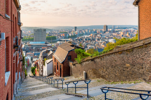
Liège is the third-largest city in Belgium, the capital of the Liège Province, and located near the borders of the Netherlands and Germany in eastern Belgium. The city has economic importance as the commercial center of the industrial scene in Meuse Valley with its foundries, refineries, mines, and factories. It’s also one of the most important river ports in Western Europe.
The majority of the population in Liège is French-speaking; Dutch and German are spoken by minority groups. Some of the most-represented immigrant groups in the city are Algerian, Moroccan, Turkish, and Vietnamese.
Another interesting feature of the city of Liège is the Montagne de Bueren, a 374-step staircase built in 1881. It was constructed to honor 600 soldiers who had died in battle during the 15th century in an attack by the Duke of Burgundy, Charles the Bold.
Charleroi
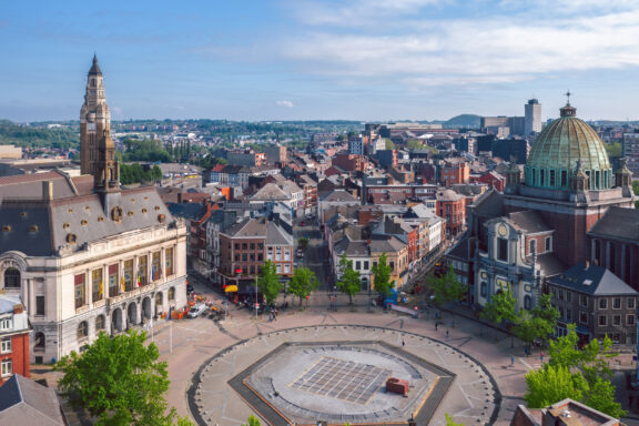
The fifth-most populous city in Belgium, Charleroi is located in the province of Hainaut in Wallonia. The area around Charleroi is notable for the industrial activities that historically took place there. Coal mining and steel production were especially big industries in this region, which gave it the name Pays Noir, meaning “Black Country.” Most of the factories have since shutdown.
There are several interesting landmarks in Charleroi, such as the City Hall, whose belfry made it on to the UNESCO World Heritage List in 1999. A number of museums can also be found in the city.
History
Belgium’s history is long and involves many empires and rulers: the Franks, Romans, Habsburgs, Spanish, and Dutch all controlled the area at one point. Eventually, Belgium became an independent nation in 1830 as part of the Belgian Revolution, when it separated from the Netherlands.
On July 12th, 1831, King Leopold I was installed as the first King in the new constitutional monarchy of Belgium. This day is still celebrated as Belgium’s National Day.
In the early days of independent Belgium, French was the only official language of the country, as it had been adopted by the nobility and bourgeoisie. Dutch later gained official recognition in 1898, and a Dutch version of the country’s constitution was accepted in 1967.
In August 1914, at the onset of World War I, Germany invaded Belgium and imposed a brutal occupation. After the war, Belgium annexed the Prussian districts of Eupen and Malmedy, which is now a small German-speaking region in eastern Belgium called Eupen-Malmedy.
In May 1940, Germany once again invaded Belgium, this time at the beginnings of World War II. The German occupation of Belgium and Holocaust led to the deaths of over 40,000 Belgians, and the country was liberated by Allied forces during 1944-1945.
As part of the aftermath of the second world war, the North Atlantic Treaty Organization (NATO) was formed, and its headquarters was installed in Brussels. Belgium was one of the founding members of the organization.
Geography
The topography of Belgium is mostly low-lying and flat; the highest point in the country has an elevation of 694 meters (2,277 feet) at Signal de Botrange. The total land and water area of the country covers 30,689 km2 (11,849 mi2), which makes it the 33rd-largest country in Europe.
Near the sea, Belgium’s coastal plain features dunes and low-lying land that is at or below surrounding water levels. Major ports connected to Belgium’s coast include the Port of Zeebrugge and the Port of Antwerp-Bruges. The second of these is the second-largest seaport in Europe.
Further inland, Belgium’s landscape includes valleys, sandy plains, rivers, and lakes. Closer to France, in the southeastern portion of Belgium, hills and plateaus are covered in forests. There is also some rockier terrain in this area, with caves and gorges.
Economy
Belgium’s economy is one of the strongest in Europe. This is partly because its economy is globalized, and the country has strong cultural, linguistic, and transportation ties with the rest of Europe.
Thanks also to its location in the center of a highly industrialized region, high productivity, and export of machinery, diamonds, chemicals, and metal products, it is one of the world’s largest trading nations.
As one of the first countries to experience the Industrial Revolution, Belgium developed mining and steelmaking capabilities in the 19th century that helped the country become one of the most industrialized nations on the planet.
Since World War II, the economic gap between the regions of Flanders and Wallonia has grown; Flanders is far wealthier than Wallonia, and this has contributed to tensions between the two.
Demographics and Culture
The sixth-most densely populated country in Europe, Belgium has an estimated 2022 population of 11,669,455 people. An especially interesting attribute of the culture in Belgium is the geographic distribution of languages spoken in the country. The map below details the regions where the country’s three official languages are spoken: Dutch (Flemish), French, and German.
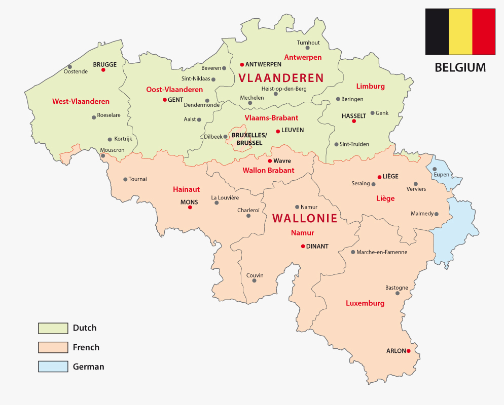
It’s estimated that about 60% of the Belgian population speaks Flemish (a dialect of Dutch) as a native language, and around 40% of the population speaks French as a native language. Since the majority of French speakers are in Wallonia, they are referred to as Walloons; this does not apply to French speakers from Brussels.
Both Flemish and Belgian French have slight differences from the varieties spoken in the Netherlands and in France, though they are entirely mutually intelligible. There is also a small community of German speakers in Eastern Belgium, made up of both Belgian and German nationals.
The linguistic and economic differences between Flanders and Wallonia are such that some would like to see a split between the two regions, each becoming its own independent state. This hypothetical situation is sometimes referred to as the “partition of Belgium.” Both regions have a high degree of autonomy as part of modern Belgium.
FAQs
What language do they speak in Belgium?
There are three official languages in Belgium: Dutch, French, and German. The dialect of Dutch spoken in Belgium is called Flemish, and there are only minor differences between it and the Dutch spoken in the Netherlands.
What is Belgium famous for?
Belgium is famous for waffles, chocolate, and beer, which can be found all over the world. It’s also famous for being the administrative center for the European Union and its national football team, the Red Devils.
Is Belgium expensive?
While there are more expensive countries in Western Europe like Switzerland, Norway, and Denmark, Belgium can still be ranked among the world’s 25 most expensive countries. The average salary is €61,357 per year in Belgium, and it has one of the highest minimum wages in the world.
Is Belgium part of France?
No, Belgium is an independent nation. French is one of the official languages, and it has a large French-speaking population, but it is its own country.
Is Belgium more French or Dutch?
Belgium has its own distinct culture, and French or Dutch-speaking Belgians are still Belgian. There are more Flemish speakers (the Belgian dialect of Dutch) than there are Belgian French speakers. Roughly 60% of the population is a native Flemish speaker, and about 40% of the population speaks Belgian French natively.
The majority of native Flemish speakers are from the region of Flanders, and the majority of Belgian French speakers are from the region of Wallonia.
🌍 More maps & data for Belgium
Browse more: All airports by country


- Colorful Map of Belgium Provinces — © brichuas/Shutterstock
- Brabo Fountain in Market Square, Antwerp — © Mistervlad/Shutterstock
- Aerial View of Ghent Cityscape with Historic Buildings — © Thomas Dekiere/Shutterstock
- Belgium Flag Pin on Map — © hyotographics@Shutterstock