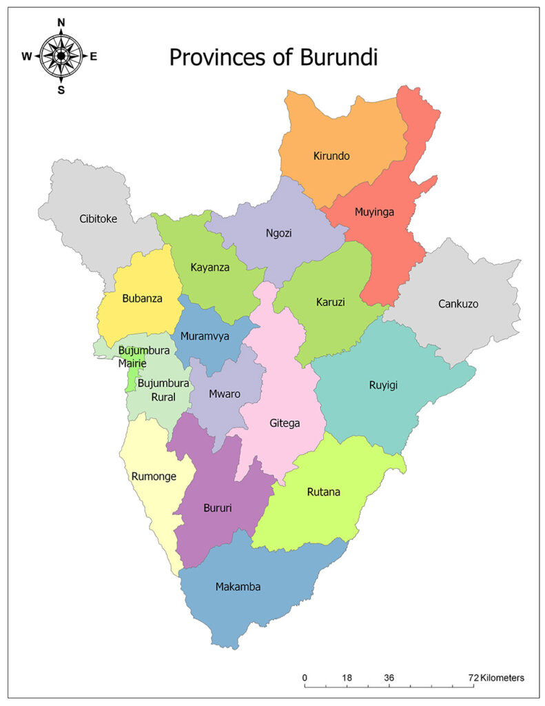
Burundi is administratively divided into 18 administrative divisions. These administrative regions are referred to as province. These provinces in Burundi have the name of the cities which are the administrative center except Bujumbura Rural. The newest province, Rumonge, was created on March 26, 2015. The province of Rumonge was previously included in the provinces of Bujumbura Rural and Bururi.
Map of the Provinces of Burundi

Eighteen Provinces of Burundi
Burundi is divided into eighteen provinces, the highest administrative division. These provinces are Cankuzo, Gitega, Rutana, Ruyigi, Karuzi, Kayanza, Kirundo, Muyinga, Ngozi, Bururi, Makamba, Rumonge, Bubanza, Bujumbura Mairie, Bujumbura Rural, Cibitoke, Muramvya, and Mwaro.
Cankuzo
Cankuzo province is one of the eighteen provinces of Burundi. The administrative center of the province, located in the east of the country, is the city of Cankuzo. Its surface area is 1,964 square kilometers and the official population of 2008 is 228,873. The estimated population of 2010 is calculated as 235,355.
Gitega
Gitega is one of eighteen provinces of Burundi. Its capital is Gitega, the national capital. As of 2008, it has a population of 725,263 and an area of 1,979 square kilometers. The province of Gitega is located in the central part of the country.
Rutana
The province of Rutana is one of the eighteen provinces of Burundi. The province is located in the southeast of the country. As of 2008, it has a population of 333,510. The province, which has a surface area of 1,959 square kilometers, is divided into six sub-administrative divisions. Rutana is the capital of the province.
Ruyigi
Ruyigi Province is one of the eighteen provinces of Burundi. The province is located in the east of the country. As of 2008, it has a population of 400,530. The province is divided into seven sub-administrative divisions with a surface area of 2,338 square kilometers. The capital of the province is Ruyigi.
Karuzi
The province of Karuzi is one of the eighteen provinces of Burundi. The province is located in the northeast of the country. As of 2008, it has a population of 436,443. The area is divided into seven sub-administrative sections with a surface area of 1,457 square kilometers. The capital of the province is Karuzi.
Kayanza
Kayanza Province is one of the eighteen provinces of Burundi. The province is located in the north of the country. As of 2008, it has a population of 585,412. The province has an area of 1,233 square kilometers and is divided into nine sub-administrative divisions. The capital of the province is Kayanza.
Kirundo
The province of Kirundo is one of the eighteen provinces of Burundi. The province is located in the northernmost part of the country. As of 2008, it has a population of 628,256. The area is divided into seven sub-administrative divisions with a surface area of 1,703 square kilometers. The capital of the province is Kirundo.
Muyinga
The province of Muyinga is one of the eighteen provinces of Burundi. The province is located in the northeast of the country. As of 2008, it has a population of 632,409. The area is 1,836 square kilometers and is divided into seven sub-administrative divisions. The capital of the province is Muyinga.
Ngozi
Ngozi Province is one of the eighteen provinces of Burundi. The province is located in the north of the country. As of 2008, it has a population of 660,717. The land area of 1.473 square kilometers is divided into nine sub-administrative divisions. Ngozi is the capital of the province.
Bururi
Bururi is one of the eighteen provinces of Burundi. The province is located in the south of the country. As of 2008, it has a population of 313,102. The province is divided into six sub-administrative sections with a surface area of 1,644 square kilometers. The capital of the province is Bururi.
Makamba
The province of Makamba is one of the eighteen provinces of Burundi. The province is located in the southernmost part of the country. As of 2008, it has a population of 430,899. The province, which has a surface area of 1,959 square kilometers, is divided into six sub-administrative divisions. The capital of the province is Makamba.
Rumonge
The Province of Rumonge is one of the eighteen provinces of Burundi. The province is located in the southwest of the country. As of 2008, it has a population of 352,026. The area is 1,079 square kilometers and is divided into five sub-administrative divisions. The capital of the province is Rumonge.
Bubanza
Bubanza Province is one of the eighteen provinces of Burundi. The province is located in the northwest of the country. As of 2008, it has a population of 338,023. The area is 1,089 square kilometers and is divided into five sub-administrative divisions. The capital of the province is Bubanza.
Bujumbura Mairie
The Bujumbura Mairie Province is one of the eighteen provinces of Burundi. The province is located in the west of the country. As of 2008, it has a population of 497,166. The province, which is 86 km2, is divided into thirteen sub-administrative divisions. The capital of the province is Bujumbura Mairie.
Bujumbura Rural
The Bujumbura Rural Province is one of the eighteen provinces of Burundi. The province is located in the west of the country. As of 2008, it has a population of 464,818. The land area of 1,059 square kilometers is divided into nine sub-administrative divisions. The capital of the province is Isale.
Cibitoke
The Province of Cibitoke is one of the eighteen provinces of Burundi. The province is located in the northwest of the country. As of 2008, it has a population of 460,435. The province is divided into six sub-administrative areas with a surface area of 1,635 square kilometers. The capital of the province is Bujumbura Cibitoke.
Muramvya
Muramvya Province is one of the eighteen provinces of Burundi. The province is located in the middle of the country. As of 2008, it has a population of 292,589. The area is 695 square kilometers and is divided into five sub-administrative divisions. The capital of the province is Bujumbura Muramvya.
Mwaro
The province of Mwaro is one of the eighteen provinces of Burundi. The province is located in the middle of the country. As of 2008, it has a population of 273,143. The province, which has an area of 839 square kilometers, is divided into six sub-administrative divisions. The capital of the province is Bujumbura Mwaro.
Burundi Facts
- Population: 11,434,600
- Population Density: 451 per Km2
- Land Area: 25,680 Km2
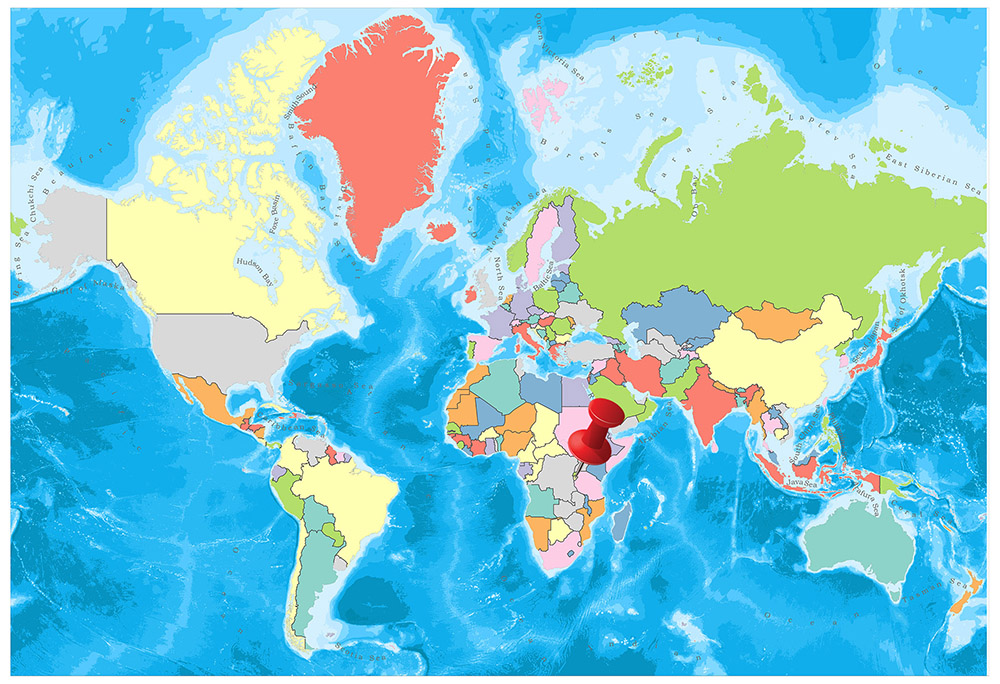
Burundi is located in the Great Lakes region of Central Africa. Neighbor to Tanzania, Rwanda, the Democratic Republic of the Congo (Zaire), Burundi has a coast with the Lake Tanganyika.

Geography
Burundi was founded at the junction of the Nile and Congo rivers. The mountain range, which is seen as infinite, characterizes it. The rough topography of the country adversely affects modern transportation and residential areas. A large part of Burundi land is over 1500 meters. Only the eastern shores of the Kuzizi Valley and Lake Tanganyika are located over 900 meters in a narrow alluvial valley. The eastern part of this area and the land suddenly rise to 2100-2700 meters along the north-east of the cross-section of the Congo and Nile waters.
Governance
Burundi is a republic managed by the constitution. The current constitution was adopted in 2005 and put into effect. Burundi has a multi-party political system and is governed by a presidential system. The head of state of Burundi serves both as the highest point of the state and as the head of the government. In Tanzania, more than 500,000 refugees were found in 2003 and this number dropped to below 150,000 in 2007.
Climate
Burundi, which is close to the equator, has a tropical climate in general, but there are also changes between regions. In many places, there is a significant difference between day and night temperatures. While the annual temperature is around 20 ° C in the plain area, temperatures around Lake Tanganyika reach up to 23 ° C and in mountainous regions, it falls down to 16 ° C. The average annual temperature is 23 ° C in the capital Bujumbura. The rainfall is irregular and the area with the most precipitation is northwest. There are 4 seasons: The long dry season is from June to August, the short rainy season is from September to November, the short dry season is from December to January and the long rainy season is from February to May.
Religion
The dominant religion throughout Burundi is the Christian religion. According to this, 84% of the population lives according to Christian beliefs. In this ratio, the rate of Christian Catholics Christians is 62.1%, the Protestant denomination is 21.6% and the other Christian sects are at 2.3%. Although Islam is the second most common religion in the country, only 2.5% of the population lives according to their Islamic beliefs. In addition to these two religions, the rate of believers in other religions is 3.6% and the rate of population without any religion is 7.9%.
Industry and Tourism
According to the world hunger index, Burundi is the poorest country in the world according to the data of the last 25 years. According to the 2014 data of the world hunger index, Burundi ranks at the end with its 35.6 index ratio among all countries.
Agricultural activities constitute the most important part of the national economy. Approximately 85% of the population is directly or indirectly involved in agricultural activities. The majority of the agricultural activities in Burundi cover the activities carried out to meet personal consumption. Coffee, cassava, banana, corn, sweet potatoes and vegetables are the most important agricultural products that are planted and grown.
In addition to agricultural activities, it is also common among livestock society. Although the number of animals in the country is high, the yield and usage obtained from this area is low. Milk and meat of cattle are used in this area.
Art
Music and dances performed in local religions in Burundi constitute an important part of the culture. With dancing called abatimbo on special occasions and weddings, the dance which is faster and called abanyagasimbo is common. It is named according to the person and the group who sing in songs that are part of the culture. The songs that the families sing together are called imvyino, only the songs of men are called kwishongora, and the songs that women sing only are called bilos. The common point of all these songs is that they are spoken in the national language Kirundi.
In addition to flute, local musical instruments, also called ikembe, indonongo, urukayamba, umuduri, inanga and inyagara, are also widely used.
In the country, theater, and visual arts are less visible. In Burundi, stories and tales are generally told and conveyed to the next generations.