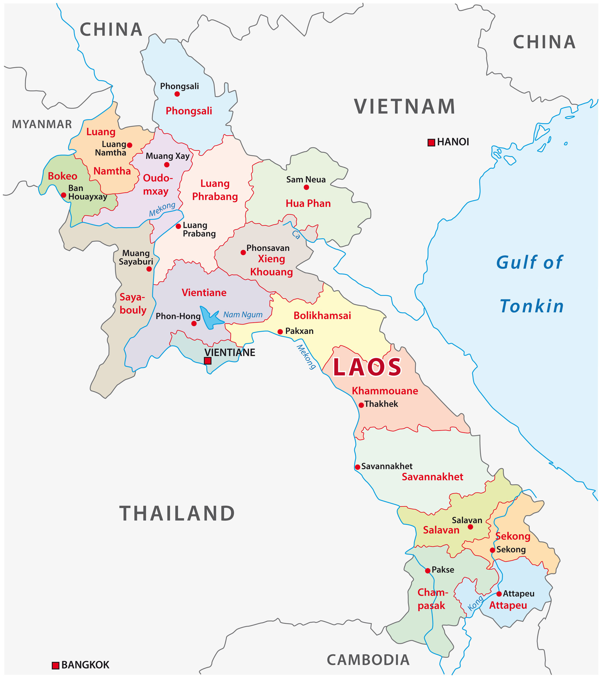
The map below shows the boundaries for Laos and all provincial capitals and other major cities.
Laos fits into three physiographic areas:
1) The north-eastern area, characterized by high mountain ranges surrounding a deeply dissected plateau covered by dense forest and interspersed with narrow valleys.
2) A panhandle in the northwest containing the fertile and densely populated Mekong River valley.
3) The southern region, comprising a wide plateau with scattered mountain ranges.
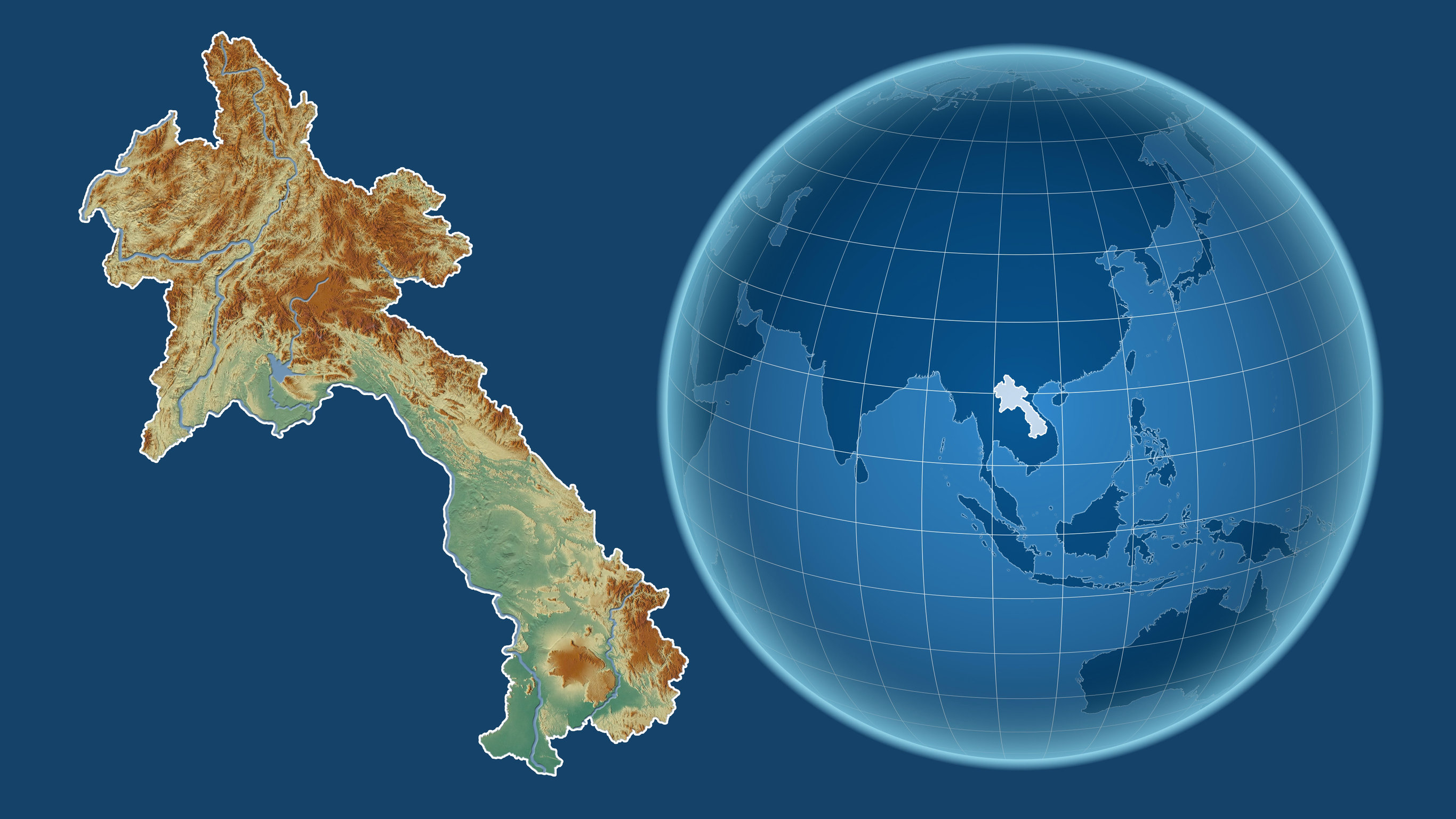
The Mekong River forms a large part of the western boundary with Thailand, whereas the eastern border is defined by the Annamite Range, a chain of mountains running parallel to Vietnam. These natural boundaries run along the borders of five of Laos’s six provinces.
The capital and largest city of Laos is Vientiane. Other major cities include Luang Prabang, Savannakhet and Pakse. The natives speak an Austroasiatic language, and the official language of Laos is Lao.
There are several distinct Lao languages spoken in Laos. More than 80 different languages/dialects have been documented.
Laos on the World Map
Where is Laos? Below, see Laos on the globe and the map of Asia:
Compared to the rest of the world, Laos is a small country, about the size of Utah in the United States. But it’s big compared to its neighbors. Laos is about the same size as Vietnam but smaller than Thailand or China. It is known for its beautiful landscapes and rich culture.
The People’s Democratic Republic of Laos is the official name.
Laos on the Map of Asia
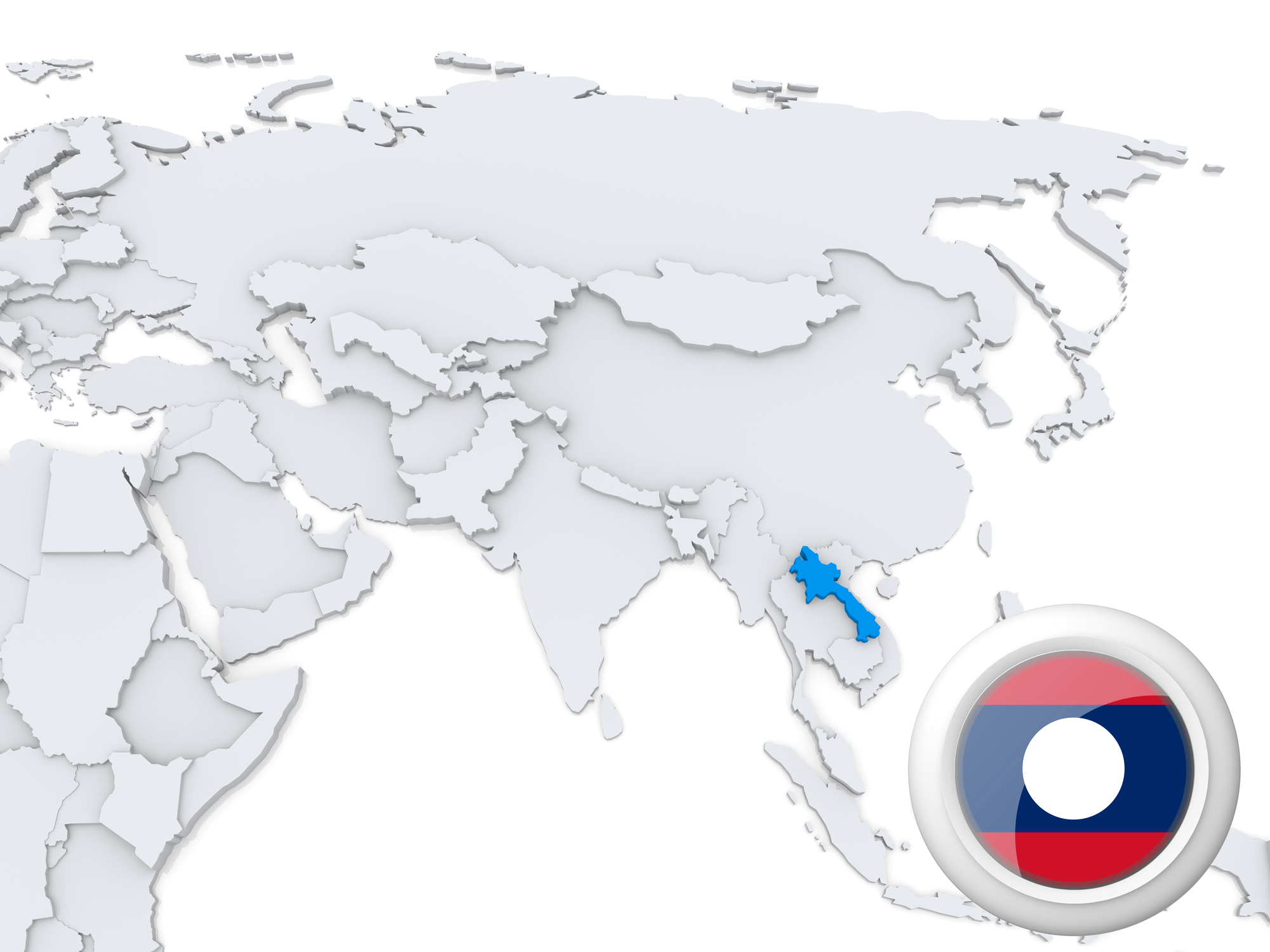
Laos is a landlocked country sharing borders with Vietnam to the east, west, and south, Cambodia to the southwest, Thailand to the northwest, and Myanmar (Burma) to the north.
At 236,800 square kilometers (91,400 sq mi), it is the world’s 41st largest country and the ninth-largest in Southeast Asia. Other countries on the continent include Kazakhstan, Turkmenistan, and Uzbekistan.
Asia is the largest and most populous continent, located primarily in the eastern and northern hemispheres. It covers 8.7% of the planet’s total surface area (or 30.2% of its land area), and with approximately 4 billion people, it hosts 60% of the current human population.
Provinces of Laos
Laos has 14 provinces, each named after the largest town in that province. Provinces divide into districts (Muang), which are subdivided into villages (ban).
There are 18 provinces of Laos:
- Attapeu Province
- Bokeo Province
- Bolikhamxai Province
- Champasak Province
- Houaphanh Province
- Khammouane Province
- Luang Namtha Province
- Luang Prabang Province
- Oudomxay Province
- Phongsaly Province
- Salavan Province
- Savannakhet Province
- Vientiane Province
- Vientiane Prefecture
- Sainyabuli Province
- Sekong Province
- Xaisomboun Province
- Xiangkhouang Province
1. Attapeu Province
Attapeu is located in the south of the country. It’s surrounded by Sekong (to the North), Champasack (to the West), Vietnam (to the East), and Cambodia (to the South).
There are nine major indigenous groups in Attapeu – the Alak, Katang, Kaleum, Katou, Suay, Nge, Lave, Tahoy, and Nyajeung tribes.
2. Bokeo Province
Bokeo borders Myanmar and is less than 100km away from China. It is the smallest province in Laos and has several groups – about 30 ethnicities.
The province was formed in 1983 after splitting off from Luang Nam Tha. The city is known as the “land of sapphires.” In the far north, gold panning and diamond prospecting are vital occupations.
3. Bolikhamxai Province
The province was formed in 1964 when Khammouan Province joined together with the northern part of Vientiane. The capital city, also named Bolikhamxai, is home to around 70,000 people.
Bolikhamxay Province is a hub for ecotourism in Laos, with two protected areas and an expansive network of swamps.
This province is also home to the Bang Fai Phayanak (Naga Rockets). It occurs on the 15th day of the 11th month of the Buddhist lunar calendar at the Phonsanh Temple, located near the Meking River.
4. Champasak Province
Champasak Province is located in the southwest of Laos and shares a border with Thailand and Cambodia. The Mekong River forms the eastern boundary while the Cambodian provinces of Preah Vihear, Ratanakiri, and Stung Treng lie to the west, north, and south respectively.
5. Houaphanh Province
Houaphanh Province has a mountainous landscape and is home to the highest peak in Laos, Phou Bia, which measures 9,100 feet. In the north of the province lies the dense evergreen forest. In recent years deforestation has been an issue in Houaphanh Province, but there are two protected areas: Pha Suong and Nam Et.
6. Khammouan Province
Khammouan Province lies in the mid-north of Laos and shares borders with three countries – Vietnam, China, and Thailand. The province covers an area of 3,213 sq km.
The major towns are Khammouane on the Mekong River, the capital, Thakhek, and the Tad Lo waterfall.
7. Luang Namtha Province
Luang Namtha Province is in the north of Laos, between China and Myanmar. The province occupies an area of 10,217 sq km. Luang Namtha means “Royal Sugar Palm” or “Royal Green River.”
8. Luang Prabang Province
Luang Prabang Province is located in the north of Laos and covers an area of 2,586 sq km. The provincial capital is Luang Prabang, which is also the national capital and a UNESCO World Heritage Site.
Lao Loum, Lao Theung, and Lao Sung are the most common ethnicities in Laos. There are also numerous hill tribes, including the Hmong, Yao, Akha, and Lisu.
9. Oudomxay Province
Oudomxay is located in the northwest of Laos and shares borders with China to the north. The province has an area of 15,370 sq km.
The province’s landscape is dominated by mountains with peaks has peaks up to 1,850 meters and large forests. The Nam Ou River flows through the province before flowing into the Mekong.
10. Phongsaly Province
Phongsaly Province is the least populated province in Laos, with people who live in eight different tribal groups. The population is made up of 28 distinct ethnic groups, including the majority Khmu, Phounoy, various Akha, Tai Lue, and Hor, each with its own cultural heritage.
11. Salavan Province
Salavan Province is located in the south of Laos, near the border with Vietnam. There is very little tourist infrastructure in the province. The larger town is Paksan on the Mekong river.
12. Savannakhet Province
Savannakhet Province is located in the south of Laos and shares borders with Vietnam to the north and east. The province covers an area of 4,610 sq km. Savannakhet means ‘the city of sandalwood’ or ‘city of love, which was originally called Muang Kao.
13. Vientiane Province
Vientiane Province is the smallest province in Laos. The province covers an area of 6,700 sq km. The province’s capital city, Vientiane, is home to most of the country’s international embassies and the Lao National Museum.
The city is home to the Patuxai, a monument built in 1969 commemorating independence from France. Most Lao people speak both French and Laotian fluently because of the country’s colonial past.
14. Vientiane Prefecture
The Vientiane Prefecture is located in the northeast of Vientiane Province and covers an area of 6,649 sq km. The prefecture is divided into 10 districts: Chanthabuly, Sikhottabong, Naxaithong, Nonghet, Xaisomboun, Saythany, Vilabouli, Nongkham, Na Hin, and Peneum.
15. Sainyabuli Province
Sainyabuli Province has an area of 16,389 square kilometers (6,328 sq mi). Bokeo Province and Oudomxai Province are located to the north of Sainyabuli. Sainyabuli means “the white elephant’s victory”.
16. Sekong Province
Sekong Province is located in the southeast of Laos and borders Vietnam to the east. The province has an area of 6,239 sq km. Sekong Province was once part of Cambodia.
Attractions in Sekong include the Tad Fane waterfalls and the Sepon copper mine. The distinctive cloth designs of Sekong, which are made from a hip loom, have become famous for their bright color combinations. The Nga people especially produce amazing textiles. The Alak also make distinctive Lao skirts (sin).
17. Xaisomboun Province
On December 13, 2013, the province of Xaisomboun in Laos’ 18th and newest province was created. It was previously a special administrative zone. It covers an area of 8,300 Km2. The province is mountainous and is the home of many forests.
The population is small, with just 80,000 people. Hmong, Khmu, Tai Dam, and Tai Phuan are among the several ethnic minorities that reside there. Groups here produce excellent handicrafts, including jar alcohol, high-quality silk, and cotton textiles, as well as non-timber
forest products.
18. Xiangkhouang Province
Xiangkhouang is an area of Laos in the nation’s northeast, on the Xiangkhoang Plateau. The province was the most severely bombed site on Earth.
The largest area of level ground in the country, apart from floodplains, is on the Xiangkhoang Plateau in the province. The hills and grassland of this region have an average elevation of 1,300 meters.
Xiangkhouang is a province located in the far north of Laos and has an area of 15,880 square kilometers. It’s mountainous.


