Key Takeaways
- Two huge quakes, 39 seconds apart. A magnitude 7.2 foreshock struck Venezuela's Caribbean coast at about 6:04 p.m. local time on 24 June 2026, followed less than a minute later by a magnitude 7.5 mainshock — a rare "doublet," in the words of the USGS.
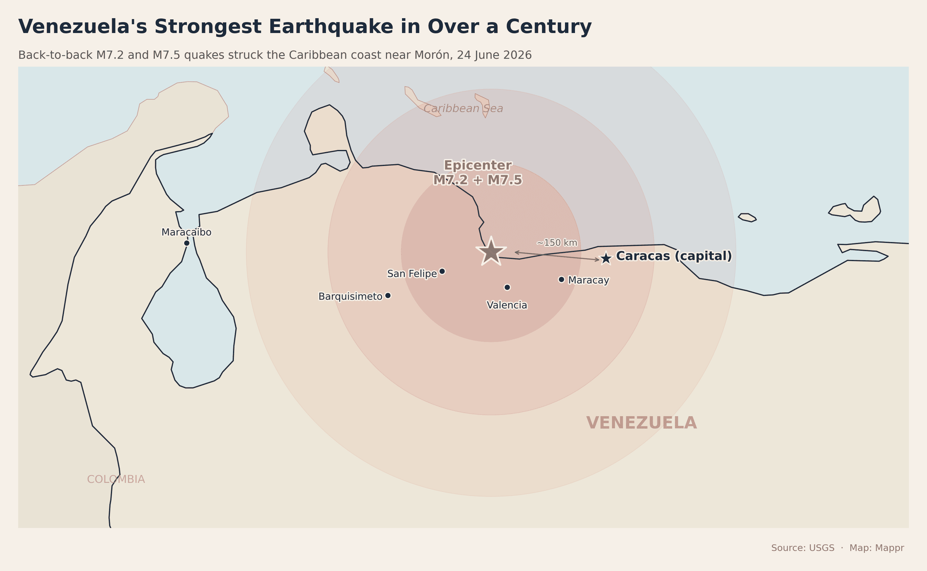
- Epicenter near Morón, ~150 km west of Caracas. Both epicenters sat near the coastal town of Morón, in the Yaracuy–Carabobo region, roughly 160 km (100 mi) west of the capital. The mainshock was just 10 km deep — shallow enough to do severe damage.
- Strongest since 1900. The M7.5 mainshock is the most powerful earthquake to strike Venezuela since a magnitude 7.7 event in 1900 — the country's biggest in over a century.
- USGS red alert. The USGS warned that "high casualties and extensive damage are probable," estimating a 44% chance the death toll tops 10,000. Buildings collapsed in Caracas and the main international airport was shut.
- Brief tsunami scare. Tsunami alerts were issued for Puerto Rico, the U.S. and British Virgin Islands and the ABC islands, then withdrawn within about an hour. The shaking was felt as far away as Bogotá, Colombia.
Venezuela was struck by the most powerful earthquake in more than a century on the evening of 24 June 2026, when two enormous tremors — a magnitude 7.2 foreshock and a magnitude 7.5 mainshock — hit the Caribbean coast less than a minute apart. Buildings collapsed in the capital, Caracas, the country’s busiest international airport was shut, and the U.S. Geological Survey warned of “high casualties and extensive damage” across a wide area.
The quakes landed on a national holiday — Venezuela was marking the 1821 Battle of Carabobo — so many people were at home when the ground began to heave. Residents poured into the streets and stayed out for hours, wary of aftershocks. The map below shows where the epicenters sat relative to Caracas and the densely populated cities of the central coast.
Casualties and latest updates
Latest developments
- June 25 — Acting President Delcy Rodríguez reports at least 32 dead and more than 700 injured. The coastal state of La Guaira is declared a disaster zone; casualties there are not yet included in the national count.
- June 25 — More than 20 aftershocks have been felt along the northern coast — La Guaira, Aragua, Carabobo and Falcón. The USGS puts the chance of a magnitude-6 or larger aftershock this week at about 40%.
- June 25 — Rescue teams report pulling at least 18 survivors from collapsed buildings, with more than 500 rescuers working in the rubble across La Guaira and Caracas.
- June 25 — The UN, the Red Cross and several Latin American countries pledge aid — search-and-rescue teams, medical supplies and food. Simón Bolívar International Airport remains closed.
What happened: a rare earthquake “doublet”
According to the USGS, the first quake — a magnitude 7.2 — struck at roughly 6:04 p.m. local time, with its epicenter on the coast near the town of Morón, about 168 km (104 miles) west of Caracas, at a depth of 22 km. Just 39 seconds later, an even larger magnitude 7.5 tremor ruptured almost the same patch of crust, this time only 10 km deep and centred about 16 km southwest of Morón. The two epicenters lay an estimated three miles apart.
Seismologists call this kind of near-simultaneous pair a “doublet.” “When the earthquakes are this close together in time, it can be difficult to unravel the exact magnitudes and the exact locations, especially for the second event,” USGS seismologist Paul Earle explained, because the seismograph signals overlap. What is not in doubt is the destructive combination at play here: a very large magnitude and a very shallow depth, directly beneath a populated, heavily built-up coastline.
Damage in Caracas and a red-level alert
Even 150 km from the epicenter, Caracas shook violently. Witnesses described walls peeling away from buildings, dust columns rising over neighbourhoods, and furniture spilling into the streets. A branch building of Bancaribe bank collapsed; parts of the capital lost power and cellphone service. Authorities closed the main Simón Bolívar International Airport at Maiquetía after it sustained damage, and cancelled classes.
The USGS PAGER system issued a red alert — its highest — warning that “high casualties and extensive damage are probable, and the disaster is likely widespread.” Its initial modelling put a 44% probability on the death toll exceeding 10,000, and a 30% chance of more than 100,000 fatalities. Acting President Delcy Rodríguez declared a state of emergency, while interior minister Diosdado Cabello urged people on state television to stay outdoors as aftershocks rattled damaged structures. Acting President Delcy Rodríguez later confirmed an initial toll of at least 32 dead and more than 700 injured — figures expected to rise (see the latest updates above).
A tsunami threat was briefly issued for Puerto Rico, the U.S. and British Virgin Islands, and the ABC islands of Aruba, Curaçao and Bonaire off Venezuela’s coast. It was withdrawn within about an hour. The tremor was felt across much of northern Venezuela and as far away as Bogotá, Colombia.
Venezuela’s strongest quake since 1900
The M7.5 mainshock is the largest earthquake to strike Venezuela since 1900, when a magnitude 7.7 event hit the same Caribbean coast. Powerful earthquakes are comparatively rare here: although Venezuela straddles a major plate boundary, it does not rupture as often as the Pacific coast of Latin America. The chart below sets the 2026 doublet against the country’s most significant past quakes.
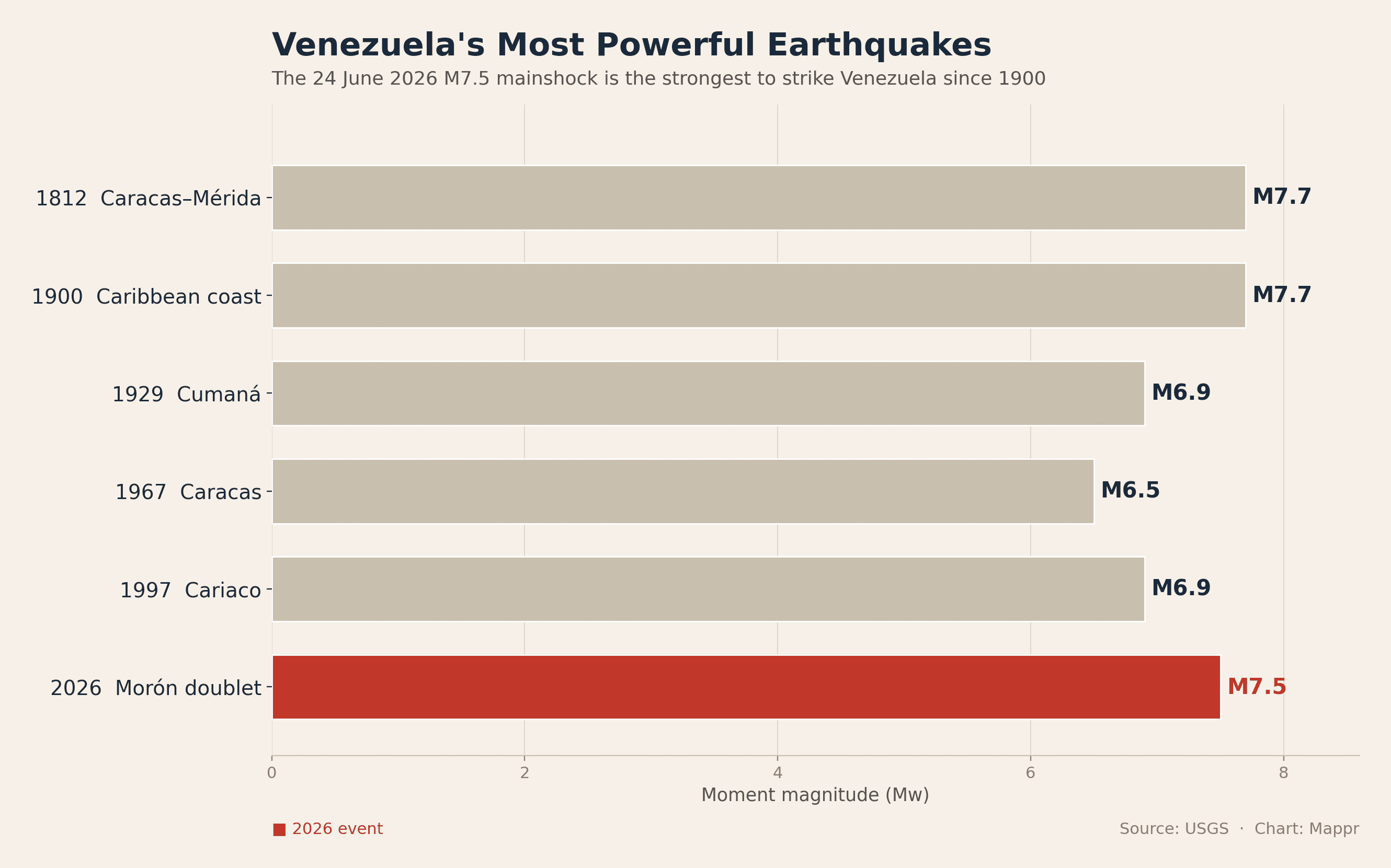
Caracas itself has a grim seismic history. A magnitude 6.5 quake in 1967 killed around 280 people and collapsed apartment blocks in the city; residents who lived through it told reporters this one felt worse. Further back, the catastrophic 1812 earthquake — which also fell on a holiday — destroyed much of Caracas and Mérida and killed an estimated 15,000 to 26,000 people.
Why Venezuela’s coast shakes
Venezuela sits along the boundary where the Caribbean Plate grinds eastward past the South American Plate at roughly two centimetres a year. Rather than one plate diving beneath the other, the two mostly slide horizontally past each other along a system of strike-slip faults — the El Pilar, San Sebastián and Boconó faults — that run across the country’s northern edge. The June 2026 rupture occurred along this coastal fault zone, the same belt responsible for the 1900 and 1812 disasters.
Shallow strike-slip quakes of this size release tremendous energy close to the surface, which is why the shaking was so intense across the central-coast cities of Valencia, Maracay and the capital region.
What comes next
The USGS expects a vigorous aftershock sequence. In the week after the mainshock, forecasters put the chance of a magnitude 6 or larger aftershock at about 40%, and called a magnitude 5 or larger aftershock all but certain. For a population already sleeping outdoors, those follow-on shocks are the immediate danger, threatening structures left weakened by the initial doublet. The full scale of the disaster — casualties, displacement and damage — will only become clear in the days ahead as rescue crews reach the worst-hit areas. We’ll update this map and post as confirmed figures emerge.
Sources: