Key Takeaways
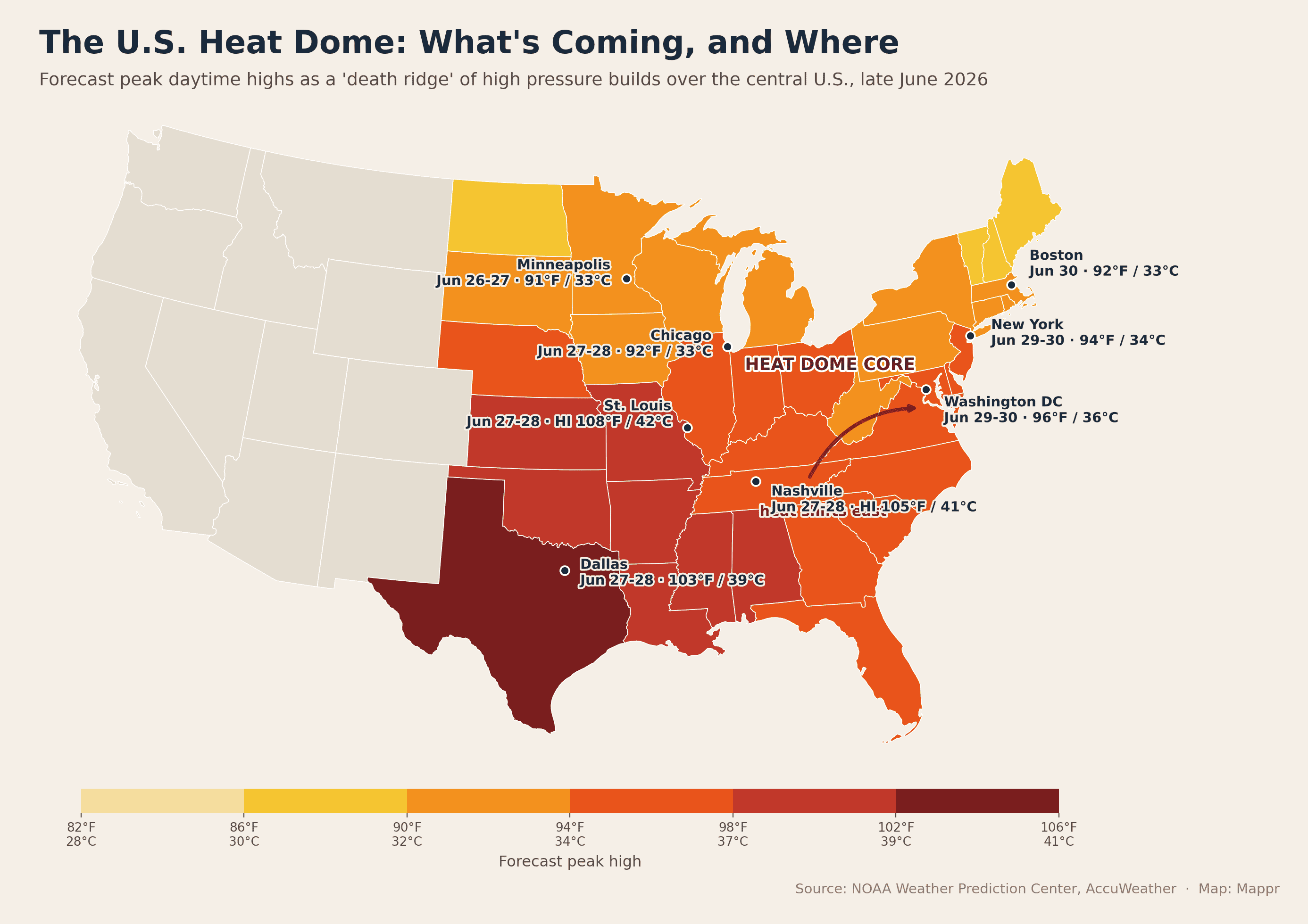
- A “death ridge” is building over the U.S. A massive heat dome is forming over the central United States ahead of the Fourth of July weekend, set to bring the most widespread 90°F-plus (32°C-plus) heat of the year so far.
- This weekend is the first peak. On 27–28 June the heat is fiercest from the Plains to the Ohio Valley. Texas hits the 100s°F (high 30s°C), and heat-index values approach 110°F (43°C) from the mid-South to the Gulf Coast.
- It shifts east by June 29–30. Early next week the dome pushes into the Northeast. The I-95 corridor, including Washington, Philadelphia, New York and Boston, climbs well into the 90s°F (low to mid 30s°C) with heat index above 100°F (43°C).
- Two continents, one week. The U.S. heat dome arrives while Europe bakes under its own “Omega block” heat dome, a reminder that extreme summer heat is hitting both sides of the Atlantic at once.
- How a heat dome works. It is a ridge of high pressure that traps hot air like a lid on a pot, pushing temperatures around 30°F (about 17°C) above normal and lingering for days.
Just in time for the second week of summer, intense heat is on the way for more than half the country. A massive heat dome, what meteorologists sometimes call a “death ridge,” is building over the central United States ahead of the Fourth of July weekend, and it is forecast to deliver the most widespread 90-degree heat of the year so far.
It arrives at a striking moment. Europe is enduring its own brutal heat dome at the same time, with records falling from Spain to the UK, so extreme summer heat is now gripping both sides of the Atlantic at once. You can follow the European side of the story in our Europe heatwave map. The map below shows the U.S. forecast and, just as importantly, how the heat will move over the next several days.
What’s coming, and when
Here is how the heat is expected to unfold over the coming days. This is a forecast, so timing and intensity may shift.
- June 26–27: Heat builds across the Plains and the Upper Midwest. Minneapolis, Chicago and the Great Lakes climb into the low 90s°F (low 30s°C), with unusually warm nights.
- June 27–28 (this weekend): The core sets up from the Plains to the Ohio Valley. Texas reaches the 100s°F (high 30s°C), and heat-index readings approach 110°F (43°C) from the mid-South to the central Gulf Coast, around St. Louis, Nashville and Memphis.
- Much of next week: The core settles over the Ohio, Tennessee and Mississippi valleys, then expands outward to the Plains, the Great Lakes, the East and the Gulf Coast.
- June 29–30: The heat shifts east. The I-95 corridor (Washington, Philadelphia, New York and Boston) sees highs well into the 90s°F (low to mid 30s°C), with heat index above 100°F (43°C).
Where the heat will be most dangerous
The raw temperature is only part of the danger. The greatest risk comes from the combination of heat and humidity, measured as the heat index, which is forecast to approach 110°F (43°C) across the mid-South and Gulf Coast where dew points are highest. Just as dangerous are the warm nights: when overnight lows stay in the high 70s or low 80s°F (mid to high 20s°C), the body never gets a chance to cool down, which is when heat waves turn deadly. Forecasters warn of possible record-high minimum temperatures during this stretch.
Two heat domes, one week
It is unusual, and telling, to see two major heat domes parked over North America and Europe in the same week. As the U.S. bakes, Europe is gripped by its own heat dome, an “Omega block” that has shattered June records in Spain, France and the UK and turned deadly. Scientists are clear that climate change does not cause any single heat dome, but it loads the dice, making these ridges hotter, more frequent and more likely to arrive early in the season.
What is a heat dome?
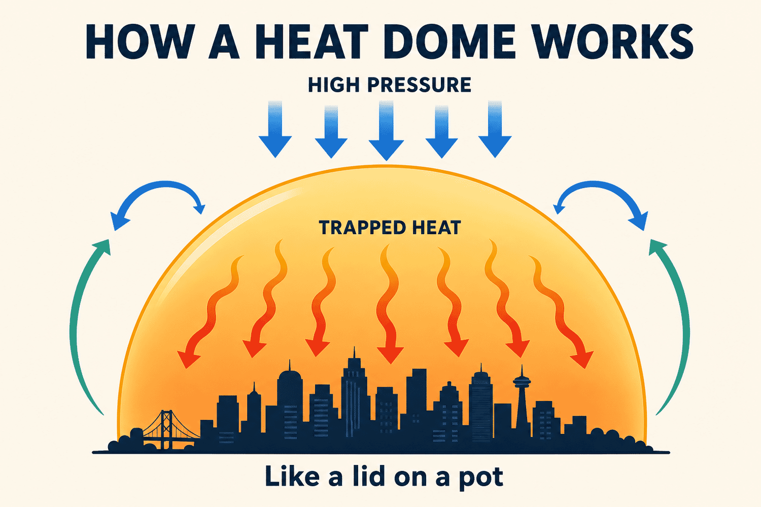
A heat dome, also called a ridge of high pressure or a “death ridge,” is a large bulge of sinking warm air that can stretch up to 1,000 miles (1,600 km). The high pressure acts like a lid on a pot, trapping hot air near the surface and driving temperatures as much as 30°F (about 17°C) above normal. Because the dome stalls in place, the heat can linger for days or even weeks, drying out the land and raising the risk of wildfires and drought as it goes.
How to stay safe
Drink water before you feel thirsty, and avoid strenuous activity during the hottest part of the day. Check on elderly neighbors, young children and anyone without air conditioning, and never leave children or pets in a parked car. Know the warning signs of heat exhaustion (heavy sweating, dizziness, nausea) and heat stroke (confusion, a body temperature above 103°F (39°C), hot dry skin), and seek shade, cool water and medical help quickly if they appear.