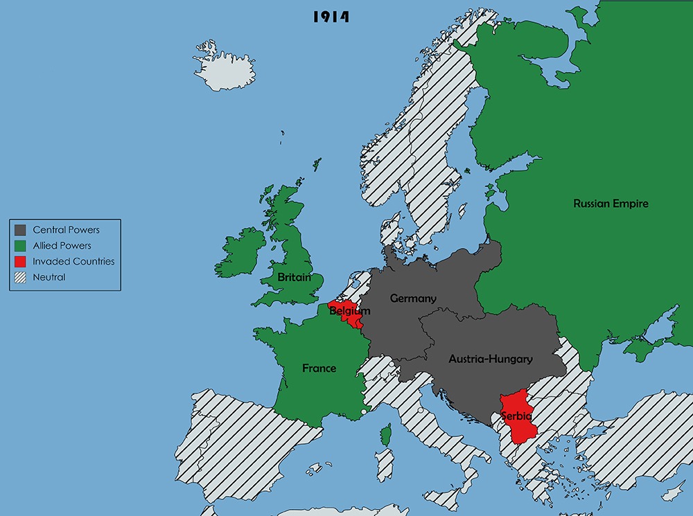
Skip to content
mappr logo
  • Home
  • Country Maps
  • Thematic Maps
  • Regions
  • Capitals
  • Flags
  • Geo Quizzes
  • Insights
  • Apps
mappr logo
  • Home
  • Country Maps
  • Thematic Maps
  • Regions
  • Capitals
  • Flags
  • Geo Quizzes
  • Insights
  • Apps

Home » Historical Maps

Historical Maps

  • Czechoslovakia/Map of Czechoslovakia
  • History, Facts, Breakup and Map of Yugoslavia
  • Soviet Union Map/Union of Soviet Socialist Republics (USSR)
  • Warsaw Pact/Members, History, Map
  • When Did U.S. States Become States?
Historical map from 1914
This map depicts Europe at the outset of World War I in 1914, showing the alignment of the major powers at that time.

Related Maps

Soviet Union Map/Union of Soviet Socialist Republics (USSR) The Union of the Soviet Socialist Republic is also known as the Soviet Union or the USSR, which was established on the same…
Warsaw Pact/Members, History, Map On May 14, 1955, the Republics of the Soviet Union formed the Warsaw Pact. In addition to this state, Czechoslovakia, Bulgaria,…
Czechoslovakia/Map of Czechoslovakia Czechoslovakia was founded on the disintegration of the Austro-Hungarian Empire at the end of World War I. In 1917, in…
History, Facts, Breakup and Map of Yugoslavia The establishment of Yugoslavia took place in the region after the end of Ottoman rule. It continued its existence from the north…
When Did U.S. States Become States? The formation of the United States was a complex and gradual process that took nearly two centuries to complete. From the…

Mapped

  • Stylized papercraft hero illustration of European manufacturing strength — layered cut-paper composition with abstract factory silhouettes, smokestacks, gear cogs, and ascending bar shapes in navy and teal
    Mapped: Eurozone Manufacturing PMI Hits Near-4-Year High in April 2026 — All 8 Surveyed Members in Expansion
  • Stylized papercraft hero illustration of global motherhood — layered cut-paper composition with world map fragments, calendar grid, carnation motifs, and abstract parent-child silhouettes in navy and teal
    Mapped: When Is Mother’s Day Around the World? — 199 Countries, Six Date Rules
  • Stylized papercraft hero illustration of global labor economics — layered cut-paper composition with abstract world map fragments, ascending bar shapes, faceless worker silhouettes with briefcases, and gear motifs in navy and teal
    Mapped: Female Labor Force Participation by Country in 2025 — MENA’s Gap, Sub-Saharan Africa’s Parity
  • Stylized papercraft hero illustration of global public health — layered cut-paper composition with abstract world map fragments, DNA helixes, microscopic virus shapes, and medical motifs in navy and teal
    Mapped: Chronic Hepatitis B Prevalence by Country (2022 Data) — WHO Global Hepatitis Report 2026
  • Stylized papercraft hero illustration of renewable electricity worldwide — layered cut-paper composition with wind turbines, solar panels, hydroelectric dams, and world map fragments in teal and navy
    Mapped: Electricity from Renewables by Country (2021 Data) — Bhutan, Lesotho, Costa Rica & Norway Lead at 99–100%
  • Stylized papercraft hero illustration of global public debt — layered cut-paper composition with world map fragments resting on rising and sinking economic pillars in navy and teal
    Mapped: Public Debt by Country in 2026 — IMF Projections Show Japan, US, and China on Diverging Paths

Travel

  • 🏙️💎 Hidden Spots in Porto: 20 Locals-Only Places to Visit in 2026 1
    🏙️💎 Hidden Spots in Porto: 20 Locals-Only Places to Visit in 2026
  • A scenic view of a city park with a large fountain in a lake, surrounded by lush greenery, walking paths, and modern apartment buildings in the background with hills on the horizon.
    🇰🇷💎 33 Hidden Gems in South Korea Best to Visit This Summer
  • A scenic waterfront with various boats docked at the harbor, modern and traditional buildings in the background, under a cloudy sky with distant mountains partially obscured by clouds.
    🇳🇴💎 33 Hidden Gems in Norway Best to Visit This Summer
  • A picturesque view of a European town with traditional buildings along a riverfront, boats moored at the quay, and a prominent church tower under a blue sky with fluffy white clouds.
    🇳🇱💎 33 Hidden Gems in the Netherlands Best to Visit This Summer

Buying Guides

  • Best globes for kids — four top interactive educational globes for children
    Best Globes for Kids: 10 Educational Picks Compared
  • Best Metal World Maps: 10 Picks Compared 2
    Best Metal World Maps: 10 Picks Compared
  • Best World Map Wall Art: 11 Picks Compared 3
    Best World Map Wall Art: 11 Picks Compared
  • Best World Atlas Books: 9 Picks Compared 4
    Best World Atlas Books: 9 Picks Compared
Countries A-Z  |  Mappr Apps  |  Mappr Maps
Terms, Conditions, and Affiliate Disclosure
As an Amazon Associate, we earn from qualifying purchases.
  • Privacy Policy
  • About Us
  • Contact Us

Copyright © 2026 Mappr

Sitemap