Maps have been helping humans understand and navigate the world for thousands of years. We can’t be sure when the first map was developed, but one of the oldest surviving examples of a map is a Babylonian clay tablet from around 600 BCE.
Smaller-scale maps of cities or regions are excellent tools for navigation and helping people get from one location to another. World maps, on the other hand, are powerful for their ability to help us conceptualize the world as a whole and visualize our place in it.
Maps are more accessible than ever — a quick Google search on a phone or computer will bring up a detailed map of just about anywhere in the world. And for those that prefer a physical map of their own, it’s never been easier to print your own. Printable world maps offer the chance to customize, display, and physically interact with a visual representation of the world.
A printable world map is also notable for its versatility — you can use it in the classroom, hang it on a wall in your house, or use it for personal study or reference, among other uses.
Available Printable World Maps
The best printable world map for one person may not be the same for another. Fortunately, there are a variety of maps available with varying levels of detail and information. It’s also important to decide whether a color or black-and-white map is the best option.
A. Unlabeled Blank World Map
This printable world map is black and white, and it doesn’t have any text whatsoever. It does display international and maritime borders. This map is nearest to a blank canvas and therefore offers the greatest potential for customization.
Teachers could use this blank printable map to create quizzes for students or to highlight any specific geographical area or feature. The white background makes it very easy to add color and marks to this map.
B. Printable World Map with Country Names

This printable world map with country names is similar to the unlabeled map in that it is easy to customize; the only difference is that each country is labeled. No bodies of water are labeled on this map.
This could be the ideal map for anyone interested in learning the location of the world’s countries or in being able to quickly reference the location of a particular country.
Also see: High-Resolution World Map
The above link to our High-Resolution World Map offers a much more in-depth picture of the world. It includes country names, bodies of water, lines of latitude and longitude, and it is colored.
How to Print Your World Map
Printing your world map is a simple, two-step process. It involves downloading the map as a PDF and then choosing the appropriate paper size and format.
A. Downloading the Map as a PDF
The first step in printing your map is to download the PDF from this page. To do this, simply click on the black “Download” button below the image of the map you wish to print. Save the image to your computer.
B. Choosing the Right Paper Size and Format
To get the most out of a printable map, it’s important to take advantage of some printing options involving paper size and format. One of the first considerations to make is what paper size you’ll be using.
A standard paper size is A4, which is 11.7 x 8.3 inches (210 x 297 mm). A3 is larger, and A5 is smaller. The maps on this page will need to be scaled down to 70% size to fit onto an A4 sheet of paper, and a 99% scale version of the map will fit on an A3 sheet.
Fortunately, the scaling is an automatic process when printing with Adobe Reader. In the below image of the printing dialogue box of Adobe, you can see that the “Fit” circle is selected in the Page Sizing & Handling section. This ensures that the image will be automatically scaled to fit the paper size selected. You can select the correct paper size from the “Page Setup…” button.

Other printing options include printing the image across multiple sheets of paper to achieve a 100% or even larger scale. This is done by selecting “Poster” in the Page Sizing & Handling section.
The maps on this page are best suited to a landscape orientation when printing.
C. Tips for High-Quality Prints
One way to achieve an even higher-quality print is to use higher-quality paper. Paper that is thicker or textured can provide a more professional or pleasing aesthetic as well as make the map more durable.
You may also want to consider laminating the map after printing, as this is a good way to preserve its quality. Lamination also makes it possible to make temporary marks on the map by using a wet-erase marker or pen.
Understanding the World Map
The world map contains a lot of information and can be useful for looking at the big picture as well as zooming in on more specific, detailed information. In many cases, it might be more efficient to look at the map of just one specific continent.
In the following section, we’ll provide a printable map of each of the seven continents. We’ll also list each of the countries in each continent.
The Seven Continents
The world is divided into seven continents, of which Asia is the largest and most populous, and Australia/Oceania is the smallest in size. The seven continents are North America, South America, Asia, Africa, Europe, Australia/Oceania, and Antarctica.
Each of the world’s continents can be divided into multiple countries, except for Antarctica. We didn’t include this continent in our printable continent maps because Antarctica is a desert without any countries or a permanent population.
There isn’t a universal agreement when it comes to defining the world’s continents. The border between Asia and Europe, for example, is disputed and difficult to define. It’s also true that, while much of the world defines North and South America as two different continents, some people define the singular American continent as containing both landmasses.
Australia and Oceania can also be defined differently. In the English-speaking world, Australia is generally considered a continent and Oceania is considered a geographical region. In the non-English speaking world, Oceania is considered a continent that includes Australia.
EUROPE
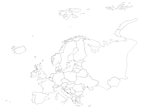
Europe is the second-smallest continent on the planet, located west of Asia and north of Africa. Although the exact number is up for debate, it is generally agreed that there are 44 countries in Europe.
Countries like Russia and Turkey are technically both in Europe and Asia, though most of their territories are in Asia. Only 3% of Turkey’s territory is in Europe, and this is why Russia has made this list and Turkey has not.
Kosovo is on this list, but it isn’t recognized as a sovereign country by every nation. Kosovo is located in Europe, in the Balkans, and declared its independence in 2008.
Cyprus is another country that could potentially be grouped with Asia or Europe. Geographically speaking, Cyprus is in Asia, as it is part of Anatolia. However, the country has very strong political, cultural, and historical ties to Europe, meaning it is often considered a European country. This is why we’ve included it in this list.
Here are the 46 countries on our map of Europe:
- Albania
- Andorra
- Austria
- Belarus
- Belgium
- Bosnia and Herzegovina
- Bulgaria
- Croatia
- Cyprus
- Czech Republic
- Denmark
- Estonia
- Finland
- France
- Germany
- Greece
- Hungary
- Iceland
- Ireland
- Italy
- Kosovo
- Latvia
- Liechtenstein
- Lithuania
- Luxembourg
- Malta
- Moldova
- Monaco
- Montenegro
- Netherlands
- North Macedonia (formerly Macedonia)
- Norway
- Poland
- Portugal
- Romania
- Russia
- San Marino
- Serbia
- Slovakia
- Slovenia
- Spain
- Sweden
- Switzerland
- Ukraine
- United Kingdom
- Vatican City (Holy See)
NORTH AMERICA
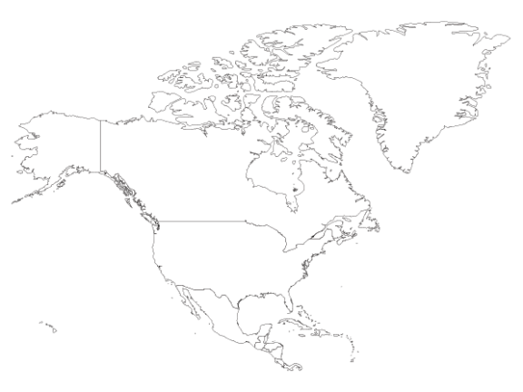
According to the UN, the North American continent consists of three regions: Northern America, Central America, and the Caribbean. There are 23 countries and many territories located in these three regions.
The Northern American mainland consists of just three countries: Canada, the United States, and Mexico. Central America is made up of seven different countries, and the Caribbean Islands are home to thirteen sovereign nations.
Some of the non-sovereign states in North America are Bermuda, Aruba, the Cayman Islands, Greenland, and Puerto Rico, among others. Although Greenland is an autonomous country, it isn’t considered sovereign because it is part of the Kingdom of Denmark.
Below, we’ve listed the 23 sovereign countries that make up North America:
- Antigua and Barbuda
- The Bahamas
- Barbados
- Belize
- Canada
- Costa Rica
- Cuba
- Dominica
- Dominican Republic
- El Salvador
- Grenada
- Guatemala
- Haiti
- Honduras
- Jamaica
- Mexico
- Nicaragua
- Panama
- Saint Kitts and Nevis
- Saint Lucia
- Saint Vincent and the Grenadines
- Trinidad and Tobago
- United States of America
SOUTH AMERICA
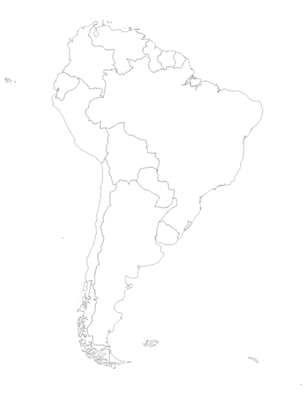
The South American continent is bordered by the Pacific Ocean to the west and the Atlantic Ocean to the east. It is generally considered to consist of 12 sovereign states, but there are also territories of countries on different continents that are located in South America. These include the Falkland Islands (United Kingdom), French Guiana (France), South Georgia and the South Sandwich Islands (United Kingdom), and Bouvet Island (Norway).
There are 12 countries in South America:
- Argentina
- Bolivia
- Brazil
- Chile
- Colombia
- Ecuador
- Guyana
- Paraguay
- Peru
- Suriname
- Uruguay
- Venezuela
ASIA
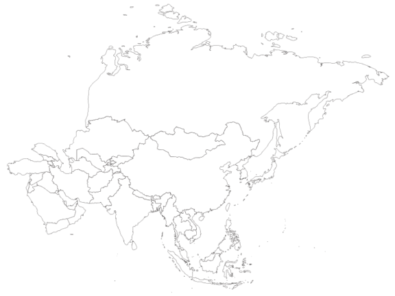
Typically, the Asian continent is thought to contain 48 countries. It is the world’s largest continent and is part of the Eurasian landmass. More than 60% of the Earth’s population lives in Asia.
It’s worth noting that the sovereignty status of countries like Taiwan and Palestine is a complex and sensitive issue with international disagreement. They are both included on this list.
This map also contains the transcontinental countries of Russia and Turkey. Both of these countries are located in both Europe and Asia — Russia is also on our Europe map — but the majority of their areas are in Asia.
Below are the 50 countries included on our printable Asia map:
- Afghanistan
- Armenia
- Azerbaijan
- Bahrain
- Bangladesh
- Bhutan
- Brunei
- Cambodia
- China
- Cyprus
- Georgia
- India
- Indonesia
- Iran
- Iraq
- Israel
- Japan
- Jordan
- Kazakhstan
- Kuwait
- Kyrgyzstan
- Laos
- Lebanon
- Malaysia
- Maldives
- Mongolia
- Myanmar (Burma)
- Nepal
- North Korea
- Oman
- Pakistan
- Palestine
- Philippines
- Qatar
- Russia
- Saudi Arabia
- Singapore
- South Korea
- Sri Lanka
- Syria
- Taiwan
- Tajikistan
- Thailand
- Timor-Leste (East Timor)
- Turkey
- Turkmenistan
- United Arab Emirates (UAE)
- Uzbekistan
- Vietnam
- Yemen
AFRICA
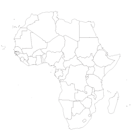
The African continent is the second-largest in the world and is made up of more countries than any other continent. It’s located in both the Northern and Southern Hemispheres and is surrounded by the Mediterranean Sea, Red Sea, Atlantic Ocean, and Indian Ocean.
There are some regions in Africa, such as Western Sahara, that are not universally recognized as independent countries. We’ve included Western Sahara in the list below and in our printable Africa map.
There are 54 countries in Africa:
- Algeria
- Angola
- Benin
- Botswana
- Burkina Faso
- Burundi
- Cape Verde
- Central African Republic
- Chad
- Comoros
- Democratic Republic of the Congo
- Djibouti
- Egypt
- Equatorial Guinea
- Eritrea
- Eswatini (formerly Swaziland)
- Ethiopia
- Gabon
- Gambia
- Ghana
- Guinea
- Guinea-Bissau
- Ivory Coast (Côte d’Ivoire)
- Kenya
- Lesotho
- Liberia
- Libya
- Madagascar
- Malawi
- Mali
- Mauritania
- Mauritius
- Morocco
- Mozambique
- Namibia
- Niger
- Nigeria
- Republic of the Congo
- Rwanda
- Sao Tome and Principe
- Senegal
- Seychelles
- Sierra Leone
- Somalia
- South Africa
- South Sudan
- Sudan
- Tanzania
- Togo
- Tunisia
- Uganda
- Western Sahara
- Zambia
- Zimbabwe
Also see: More blank and colored maps of Africa
AUSTRALIA / OCEANIA
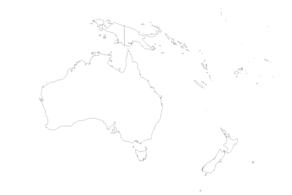
Oceania is a geographical region that includes the continent of Australia as well as thousands of islands in nearby waters; Oceania is also sometimes described as a continent in itself. In either case, Australia/Oceania is the smallest continent in the world.
There are 14 different countries in Australia/Oceania as well as a number of territories and dependencies of countries located outside of the region. Some of these include French Polynesia (France), Guam (USA), and Norfolk Island (Australia).
Below are the 14 countries on the printable Australia/Oceania map:
- Australia
- Fiji
- Kiribati
- Marshall Islands
- Micronesia (Federated States of)
- Nauru
- New Zealand
- Palau
- Papua New Guinea
- Samoa
- Solomon Islands
- Tonga
- Tuvalu
- Vanuatu
How to Use Printable World Maps
There are a number of uses for printable world maps, and we’ll take a look at some of the most common uses in this section. The ease with which they can be printed and customized makes these reference tools especially useful for study, personal interest, and even decoration.
A. In Geography Studies
Maps are one of the primary tools used in understanding and talking about geography. They make it possible to visualize specific areas of the world and to quickly reference important information. In the interest of studying geography, a printable world map is an excellent medium for learning the names and locations of countries or geographic features.
Not everyone learns information in the same way. In fact, there are four different main types of learning styles. Two of these, visual and kinesthetic learners, are likely to see major benefits from working with something like a printable world map.
Maps help visual learners by offering a picture of the material, and they are suited to kinesthetic learners by offering a chance to physically interact. Coloring in different sections of the map or covering up the names of countries you want to memorize are great ways to facilitate kinesthetic learning.
B. In Education
As mentioned in the section on geography studies, printable world maps can be exceptionally useful for providing visual and kinesthetic learning opportunities. This is useful for teachers looking to facilitate better learning in the classroom.
Printable maps also lend themselves to the creation of worksheets. By printing a map and leaving out information that needs to be filled in, students can test their geography knowledge in an interesting format.
One example of an assignment that could use a printable map is tasking students with adding geographical features like rivers, mountains, volcanoes, forests or deserts. Students could also be asked to color each continent a different shade, to only label the countries on one continent, or to write in as many capital cities as they can.
It’s also possible to make a creative learning environment by encouraging students to customize their printed maps.
C. In Personal Use
In addition to their utility in educational and professional contexts, printable world maps are great for personal use. Some of the most popular personal uses for these maps might be to plan or record travel as well as create wall art.
Maps are great tools for planning travel. Especially when traveling somewhere new, a map is an invaluable resource that can help with decisions regarding accommodation and itineraries.
Maps can also be a fun way to keep track of all the traveling you’ve done so far. One popular way to do this is to print out a large map and then mark the destinations you’ve been to with a pushpin.
It’s also possible to create art with a printable world map. For best results, print the map on quality paper and then frame it.
Customizing Your Own Printable World Map
The possibility of customizing your own printable world map is perhaps the best reason to print your own. The two main ways to customize a printed map are with digital tools and manual customization. We’ll go over both of these in this section.
A. Manual Customization and Adding Personal Points of Interest
This is the most accessible method of customization and involves physical tools. Hand-drawn elements can make great additions to a map and can be achieved with traditional art supplies such as pencils, pens, markers, and paint.
One way to use this method to make a map your own is to label countries, cities, or landmarks that interest you. You could also add symbols or country flags to the map. Drawing in a compass rose is another option.
If drawing isn’t a strong suit, you can opt to add stickers or cutouts to represent points of interest on the map. You could also make a collage by including cutout text from relevant magazines or travel brochures.
B. Using Digital Tools for Customization
Digital tools are another method for customizing a printable map, and they offer a wide range of possibilities. Some kind of image editing software is necessary for this type of customization, such as Adobe Photoshop, Adobe Illustrator, or GIMP (GNU Image Manipulation Program).
With a digital tool, it’s possible to draw geographical features such as rivers or mountains, add colors and shading to different regions of the map, add custom labels, and much more. After editing the image in the software, you’ll need to save and export the image as a printable file such as PDF, JPEG, or PNG.
In Conclusion
We’ve come a long way from the first maps carved into stone thousands of years ago. The ease with which anyone can print their own map today is remarkable. Printable world maps are especially valuable because they are customizable and come in a variety of forms. Whether it’s for education, research, personal study or interest, there’s certainly a printable map that will match your needs.
Additional Resources and References
A. Links to resources for downloading and printing world maps
B. Links to digital tools for customization
C. Links to additional maps


