When people hear “desert,” they picture scorching sand and blazing sun. But the world’s largest desert is actually a frozen wasteland: Antarctica. Covering 14.2 million km² — roughly 1.5 times the size of the United States — the Antarctic Ice Sheet receives less precipitation than the Sahara, making it the driest continent on Earth. Yes, Antarctica is technically a desert, and it’s the biggest one we have.
This might sound like a quirky geographical fact, but it reveals something fundamental about how deserts work. A desert isn’t defined by heat — it’s defined by precipitation. Any region that receives less than 250mm (10 inches) of annual precipitation qualifies as a desert. Parts of Antarctica’s interior receive less than 50mm per year — drier than Death Valley.
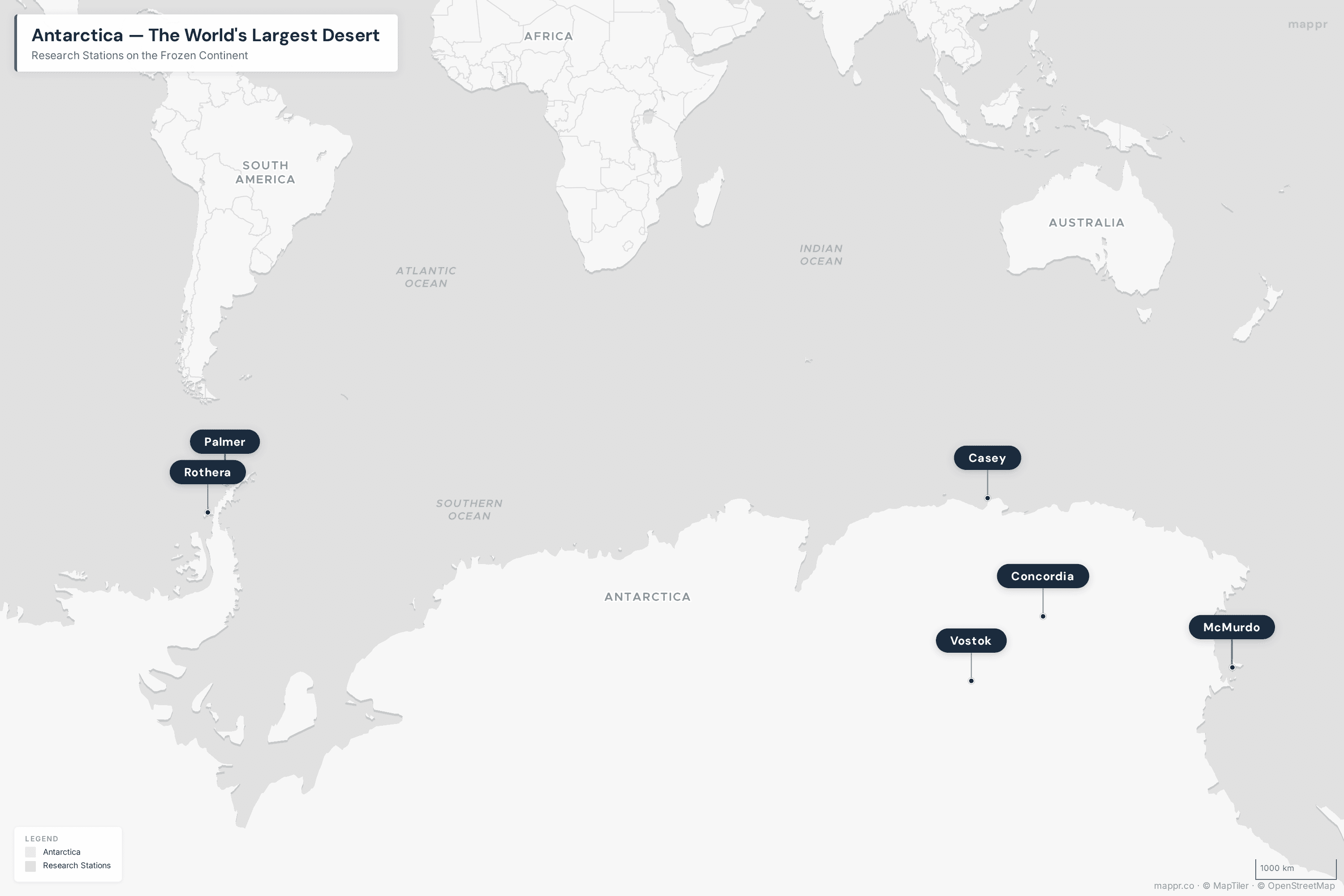
Map: Antarctica — The Polar Desert
Key Takeaways
- Antarctica is the world’s largest desert at 14.2 million km² — larger than the Sahara (9.2 million km²) by a wide margin.
- Interior Antarctica receives less than 50mm of precipitation per year, making it drier than most “hot” deserts. What little precipitation falls arrives as snow.
- The ice sheet is up to 4,776 meters thick and contains about 26.5 million km³ of ice — roughly 70% of all fresh water on Earth.
- The coldest temperature ever recorded on Earth was -89.2°C (-128.6°F) at Vostok Station, Antarctica, in July 1983.
- If the Antarctic Ice Sheet melted entirely, global sea levels would rise by approximately 58 meters (190 feet) — enough to submerge most coastal cities.
Why Is Antarctica a Desert?
The scientific definition of a desert is straightforward: any region receiving less than 250mm of precipitation annually. By this measure, Antarctica qualifies easily — its interior plateau averages only 50mm per year, and some ice-free valleys (the McMurdo Dry Valleys) haven’t seen rain or snow for an estimated 2 million years.
Several factors create Antarctica’s extreme aridity:
- Extreme cold: Cold air holds far less moisture than warm air. At -50°C, the air simply cannot carry significant water vapor.
- High altitude: The ice sheet’s average elevation is 2,300 meters — the highest of any continent. Higher elevation means colder, drier air.
- Polar circulation: Persistent high-pressure systems over the continent push moisture-bearing clouds away from the interior.
- Katabatic winds: Dense, cold air flows downhill from the ice sheet at speeds up to 300 km/h, creating the windiest conditions on Earth and further desiccating the air.
Antarctica by the Numbers
| Metric | Value |
|---|---|
| Total area | 14.2 million km² (5.48 million mi²) |
| Ice sheet area | 13.72 million km² (98% of continent) |
| Average ice thickness | 2,160 meters (7,087 ft) |
| Maximum ice thickness | 4,776 meters (15,669 ft) |
| Volume of ice | 26.5 million km³ |
| Average annual precipitation | ~50mm interior, ~200mm coast |
| Coldest recorded temperature | -89.2°C (-128.6°F) — Vostok Station, 1983 |
| Average winter temperature (interior) | -60°C (-76°F) |
| Average summer temperature (coast) | -2°C to +2°C (28–36°F) |
| Wind speeds | Up to 300 km/h (186 mph) katabatic winds |
| Permanent population | 0 (1,000–5,000 researchers seasonally) |
| Number of research stations | ~70 (from 30+ countries) |
| Fresh water stored | ~70% of Earth’s total |
The Two Ice Sheets
Antarctica’s ice sheet is divided into two main sections by the Transantarctic Mountains:
East Antarctic Ice Sheet
The East Antarctic Ice Sheet (EAIS) is far larger and more stable than its western counterpart, covering about 10.2 million km². It contains enough ice to raise global sea levels by 52 meters if it melted entirely. The EAIS sits on bedrock that is largely above sea level, making it relatively resistant to marine ice sheet instability. However, recent research has shown that even this “stable” ice sheet is losing mass faster than previously thought, particularly along the coast.
West Antarctic Ice Sheet
The West Antarctic Ice Sheet (WAIS) is smaller (~3.3 million km²) but far more vulnerable. Much of it sits on bedrock below sea level, making it susceptible to marine ice sheet collapse. The Pine Island and Thwaites glaciers — both in the WAIS — are among the most closely monitored glaciers on Earth. Thwaites, nicknamed the “Doomsday Glacier,” is retreating at an alarming rate and could trigger a cascade of ice loss that would raise sea levels by 3 meters or more.
The McMurdo Dry Valleys: Earth’s Driest Place
The McMurdo Dry Valleys near the coast of East Antarctica are perhaps the most alien landscape on Earth. These ice-free valleys (about 4,800 km² in total) are kept clear of snow by fierce katabatic winds. Some have not received any precipitation for an estimated 2 million years.
NASA uses the Dry Valleys as an analog for Mars — the conditions (extreme cold, extreme dryness, intense UV radiation) are the closest thing on Earth to the Martian surface. Despite the harsh conditions, extremophile organisms have been found living inside translucent rocks, using photosynthesis in what little sunlight penetrates the stone.
Life in the Antarctic Desert
Despite being a desert, Antarctica supports a surprising array of life — concentrated almost entirely along the coasts and surrounding seas:
- Emperor penguins breed on the ice during the brutal Antarctic winter, enduring temperatures of -60°C and winds of 200 km/h
- Antarctic krill (Euphausia superba) form the foundation of the Southern Ocean food web — their total biomass is estimated at 500 million tonnes
- Tardigrades and nematodes survive in the soil of ice-free areas, enduring freeze-thaw cycles that would kill most organisms
- No land mammals, reptiles, or amphibians live on the continent
- The largest purely terrestrial animal is the Antarctic midge (Belgica antarctica), a wingless fly just 6mm long
Antarctica vs. Other Deserts
| Feature | Antarctica | Sahara | Arctic Desert |
|---|---|---|---|
| Area | 14.2M km² | 9.2M km² | 13.9M km² |
| Type | Polar | Subtropical (hot) | Polar |
| Annual precipitation | ~50mm interior | ~76mm average | ~150mm average |
| High temperature | +18.3°C (record) | +58°C (disputed) | +30°C (record) |
| Low temperature | -89.2°C (record) | -11°C (record) | -68°C (record) |
| Permanent population | 0 | ~2.5 million | ~4 million |
| Countries | 0 (treaty territory) | 11 | 8+ |
Climate Change and Antarctica’s Future
The Antarctic desert is changing. Key trends include:
- Ice loss is accelerating: Antarctica lost an average of 150 billion tonnes of ice per year between 2002 and 2020, according to NASA’s GRACE satellite data
- Sea ice reached a record low in February 2023, with just 1.79 million km² of extent — well below the previous record
- The Antarctic Peninsula (the arm reaching toward South America) is one of the fastest-warming regions on Earth, with temperatures rising 3°C since the 1950s
- The “Doomsday Glacier” (Thwaites) could trigger 3+ meters of sea level rise if it collapses, and researchers are closely monitoring its grounding line
The Antarctic Treaty System
Antarctica is the only continent with no permanent population and no sovereign government. The Antarctic Treaty, signed in 1959 by 12 nations and now ratified by 54 countries, designates the continent as a scientific preserve and bans military activity. Key provisions include:
- Freedom of scientific research
- A ban on military activities and nuclear testing
- A ban on mineral mining (Protocol on Environmental Protection, 1991)
- Territorial claims are frozen (not abandoned) — 7 nations have overlapping claims
Methodology
Data on Antarctica’s ice sheet, precipitation, and temperature records are sourced from NASA, the British Antarctic Survey, and the Intergovernmental Panel on Climate Change (IPCC). Desert classification follows the standard climatological definition of less than 250mm annual precipitation. Comparisons with other deserts use data from the same sources cited in our Largest Deserts in the World ranking.


This post uses data from the following sources.
Data Sources:
- Antarctic Ice Sheet Mass Balance – NASA Climate
- Polar Ice Sheets and Climate Change – IPCC Special Report on the Ocean and Cryosphere
- British Antarctic Survey – British Antarctic Survey
- Antarctica – Encyclopædia Britannica