Key Takeaways
- The US has renamed Lake Ontario 'Lake America'. An executive order signed on 27 August 2026 directed the renaming in the US federal gazetteer (GNIS) within 30 days. It binds US federal maps and documents, and nothing else.
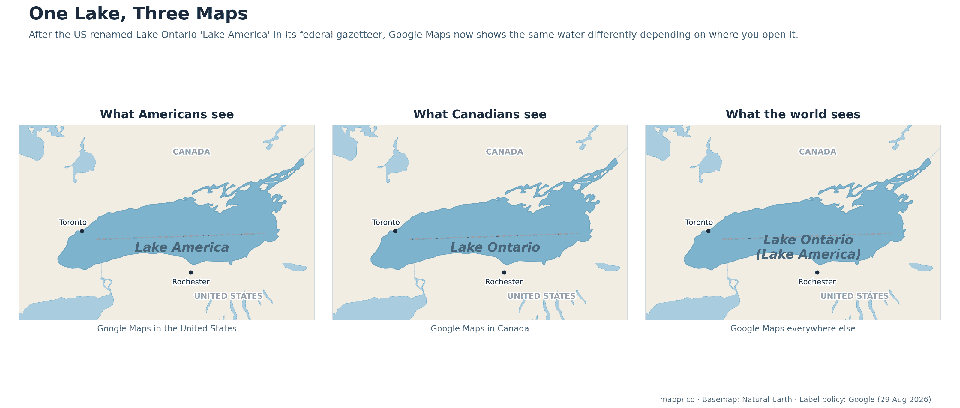
- Google Maps now shows three different lakes. Following its standing policy for disputed names, Google shows 'Lake America' to US users, 'Lake Ontario' to Canadians, and both names to everyone else, the same treatment the Gulf of Mexico received in 2025.
- Canada is not amused, and not renaming. PM Mark Carney: the 400-year-old name stands 'today and forever'. Ontario Premier Doug Ford answered with a giant 'Lake Ontario' sign, noting his province is literally named after the lake.
- The name is four centuries older than both countries. 'Ontario' derives from an Iroquoian word usually rendered as 'beautiful lake' or 'great lake', recorded by the 1640s. The province took its name from the lake, not the other way round.
- Cartography is becoming jurisdiction-relative. After Gulf of America and Denali, this is the third major US renaming since 2025, and the clearest sign yet that the map you see now depends on where you are standing when you open it.
On 27 August 2026, an executive order titled Honoring the American History of the Great Lakes instructed the US Interior Department to rename Lake Ontario, the easternmost Great Lake, as Lake America in the federal Geographic Names Information System. Two days later Google began rolling the change into its maps. Canada, whose largest province is named after the lake, declined to participate. The result is something cartographers have been quietly warning about for years: the same water now carries different names depending on where you open the map.
How one lake became three maps
Google’s handling follows its long-standing policy for names that vary between countries: display each country’s official name to its own users, and both to everyone else. Because the US official source (GNIS) now says Lake America and Canada’s official source still says Lake Ontario, the label you see is decided by your location. It is exactly how the company handled the Gulf of Mexico becoming the Gulf of America for US users in February 2025, and how contested names like the Persian Gulf / Arabian Gulf have long been shown. What is new is applying that machinery to the middle of the US-Canada border.
| Who | What they call it | Notes |
|---|---|---|
| US federal government | Lake America | GNIS changed; binding for federal maps, documents, agencies |
| Google Maps (US users) | Lake America | Rolled out from 29 August |
| Google Maps (Canadian users) | Lake Ontario | Canada’s official name unchanged |
| Google Maps (rest of world) | Lake Ontario (Lake America) | Both names shown |
| Canada, Ontario | Lake Ontario | “Now and forever”, per Premier Doug Ford |
| Apple Maps, Bing, OpenStreetMap | Lake Ontario | Unchanged as of 31 August |
| Associated Press | Lake Ontario | Continues using the international name in coverage |
The lake, the province, and a 400-year-old name
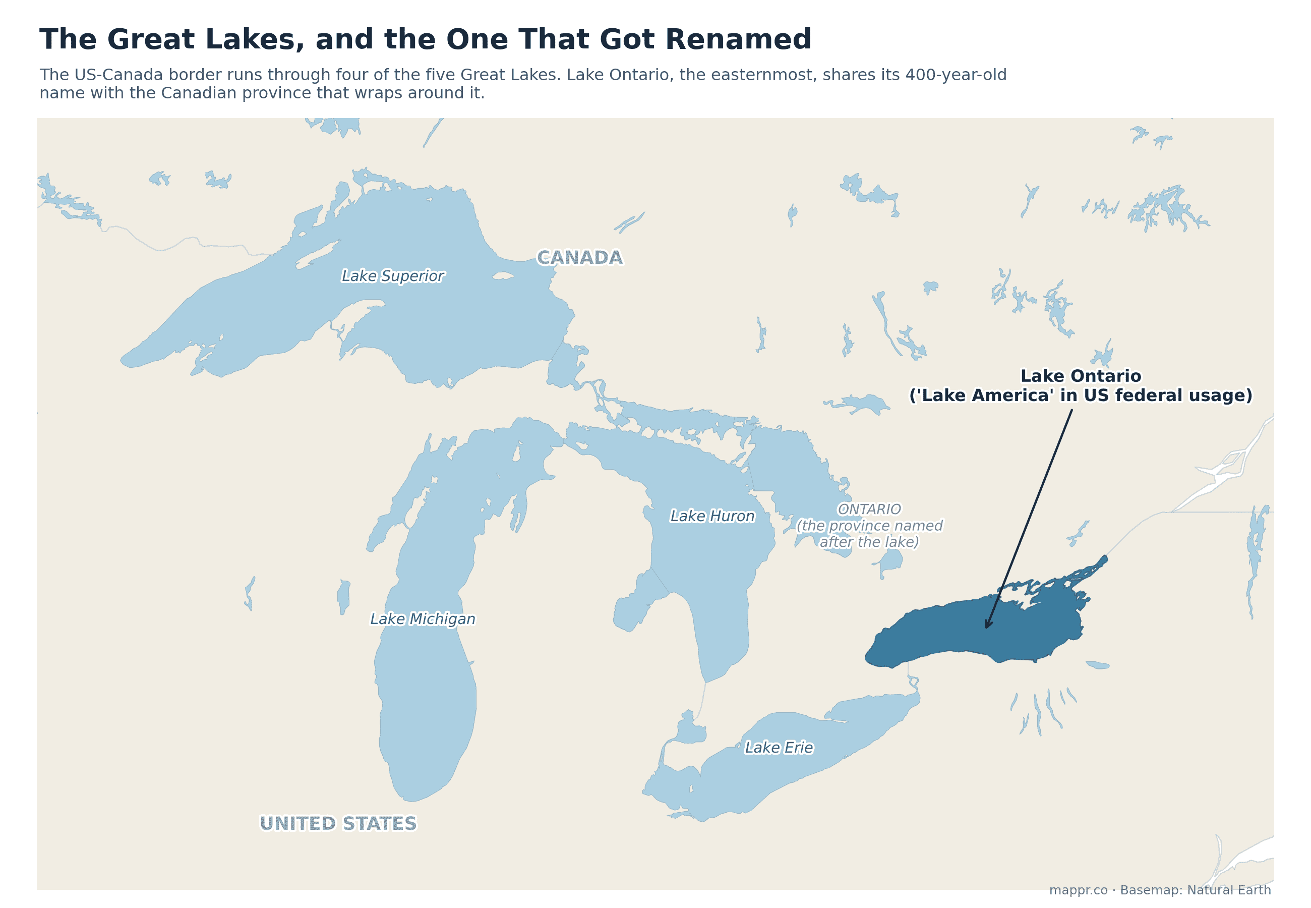
The renaming has a structural quirk the US cannot order away: Ontario, Canada’s most populous province, is named after the lake. The word comes from an Iroquoian term, usually rendered as Ontarí:io, ‘great lake’ or ‘beautiful water’, and appears on European maps from the 1640s, roughly 140 years before the United States existed. The border runs through the middle of the lake; a bit over half its shoreline is Canadian. PM Mark Carney‘s response was flat: Canadians will call it Lake Ontario ‘today and forever’. Premier Doug Ford went further, unveiling a giant roadside ‘Lake Ontario’ sign and predicting: ‘Long after President Trump is gone, it will still be called Lake Ontario.’
The precedent: a pattern, not a one-off
This is the third major US renaming since January 2025, after the Gulf of Mexico → Gulf of America and Denali → Mount McKinley. The Gulf case set the template for everything now happening: GNIS changed, Google followed for US users, Mexico objected, and the Associated Press, which kept writing ‘Gulf of Mexico’ for its global audience, was barred from White House events until a federal court ruled the retaliation unconstitutional. AP is so far keeping ‘Lake Ontario’ too, and Apple, Bing and OpenStreetMap had not adopted the new name as of the end of August.
What it means for maps from here
For most of the last century, place names moved toward international standardisation. What the last two years have shown is the reverse gear: a national government can rewrite its own gazetteer at will, and the world’s dominant map, which personalises itself to your location, will dutifully split reality along the border. Cartographers call the underlying concepts endonym and exonym; what is genuinely new is server-side cartography, where there is no longer one printed map to argue over, only millions of personalised ones. It is a theme we keep returning to in our series on how maps get made and manipulated: see what happened when AI drew Africa and Google Earth’s brush with fake satellite imagery. The lake, for its part, remains 19,000 square kilometres of cold fresh water, indifferent to what either shore calls it.
Sources: