Key Takeaways
- A landslide dammed the Budhi Gandaki River, then the dam burst. The blockage formed near Chumchure in Gorkha District on October 11; the impounded water broke through as a debris-laden surge that tore down the valley.
- The flood ran straight down the Manaslu Circuit at peak season. Jagat, Sirdibas and Machhakhola are trekking stops; about 95 people were rescued, including nine foreign trekkers, with 200+ more evacuated on October 12.
- Five bridges are gone, cutting the valley in pieces. Two trek suspension bridges, the Soti motor bridge, and the Arughat bridge linking Gorkha and Dhading were destroyed; isolated villages depend on army helicopters.
- Five people are missing; no deaths confirmed so far. Two women and three men who sheltered near the Ungilung stream in Chumchet. Three hydropower project sites were also damaged.
For the second time in four months, a Himalayan river in Nepal turned into a battering ram. On Saturday, October 11, a landslide slid into the Budhi Gandaki River near Chumchure in northern Gorkha District, pooling the river behind a wall of debris. When the blockage failed, the stored water burst downstream as a flash flood that reached towns 50 kilometers south within hours.
The Map: Down the Manaslu Trail
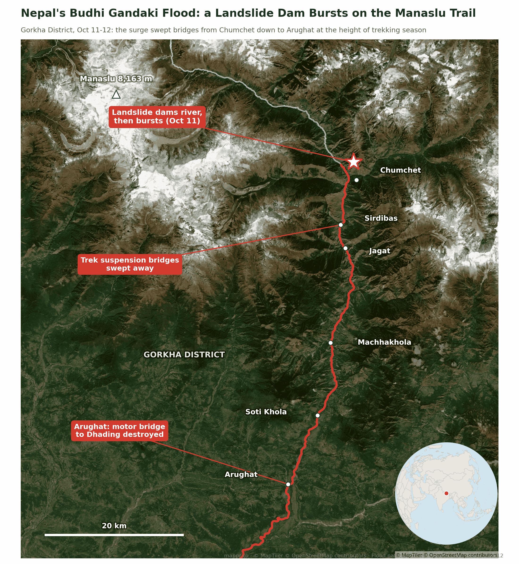
The geography is what makes this flood sting: the Budhi Gandaki gorge is the famous Manaslu Circuit, one of Nepal’s great treks, and October is its busiest month. Jagat, Sirdibas and Machhakhola, all marked on the map, are standard overnight stops. The Nepali Army plucked about 95 people, including nine foreign trekkers, from the valley by helicopter and ground teams, and evacuated more than 200 on Sunday.
What the Surge Took
🌉 Bridges: five destroyed, including the suspension bridges between Nyakchet and Sirdibas and between Machhakhola and Kerauja (both trek lifelines), the Soti motor bridge, and the Arughat bridge that connects Gorkha with Dhading.
🏠 Homes and farms: dozens of houses swept away or damaged along the river, with Chumnubri and Dharche rural municipalities hit hardest.
⚡ Hydropower: construction sites and equipment of three projects damaged, including a Bailey bridge of the 14.15 MW Dobhan Khola project.
🔍 People: five missing, two women and three men who were staying in a shed near the Ungilung stream in Chumchet. No deaths had been confirmed as of Sunday evening.
A Pattern, Not a One-Off
This is Nepal’s second major landslide-and-water disaster of 2026, after July’s avalanche-dammed flash flood at Rasuwagadhi, in a different basin 60 kilometers east. The mechanism, a river briefly dammed by mountain debris and then released all at once, is becoming the signature Himalayan hazard: steep young terrain, intensifying rain, and more infrastructure and trekkers in the valleys than ever. It is the same arithmetic of exposure and vulnerability that the WorldRiskIndex prices in, and mountain valleys compress it into minutes.
We will update this page as the missing are accounted for and the bridge damage is fully surveyed.
Data and reporting for this article come from the following sources: