Key Takeaways
- Trudy is a Category 3 and still strengthening. As of NHC advisory 11A (October 16), it carries 120 mph winds at 957 mb, about 500 km south of the Mexican coast, and is forecast to peak near Category 4 strength.
- Third storm aimed at the same 400-km stretch of coast in a month. Hurricane Polo (Cat 5) skirted it in late September, Simon (Cat 4) scraped past on October 11-12, and Trudy's cone now points at the Michoacan-Colima-Jalisco corridor for this weekend.
- Watches and warnings are already up. A Hurricane Watch covers the coast from Punta San Telmo to Cabo Corrientes; a Tropical Storm Warning runs south from Punta San Telmo to Zihuatanejo.
- Rain is again the big killer risk. The NHC forecasts 4 to 8 inches with isolated totals near 12 inches across southwestern Mexico: flash-flood and mudslide territory, on ground soaked by two previous storms.
Mexico’s Pacific coast cannot catch a break. Hurricane Trudy strengthened into a Category 3 early Thursday and is forecast to keep intensifying as it tracks north-northwest, with its forecast cone squarely over the same Michoacan-Colima-Jalisco coastline that Hurricane Polo and Hurricane Simon menaced in the past four weeks. A live tracker and the full forecast picture below.
Live Tracker
The map below updates automatically with each NHC advisory.
The Forecast Map: Advisory 11A
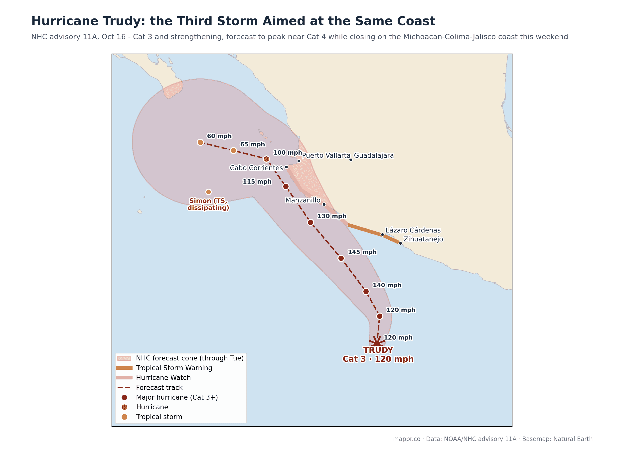
The forecast calls for Trudy to peak near 145 mph (Category 4) on Saturday while turning toward the coast, then weaken as it closes in: near Manzanillo as a major hurricane Sunday, brushing Cabo Corrientes and the Puerto Vallarta area into Monday, before bending back out to sea as a tropical storm. The track is a near-replay of Simon’s, and the margins are just as thin: a small eastward shift means landfall, a small westward one means another close call.
Warnings and Hazards
🔴 Hurricane Watch: Punta San Telmo north to Cabo Corrientes.
🟠 Tropical Storm Warning: Punta San Telmo south to Zihuatanejo.
🌧️ Rainfall: 4 to 8 inches (100-200 mm), isolated near 12 inches (300 mm), across coastal southwestern Mexico: flash floods and mudslides on terrain already saturated by Simon’s passage days ago.
🌊 Surf and surge: life-threatening surf and rip currents are spreading along the coast, with storm surge near wherever the center comes closest.
Three Storms, One Coast, One Month
This corridor has now been threatened by Polo (Category 5, late September), Simon (Category 4, October 11-12), and Trudy, three major hurricanes in four weeks, all riding the same steering pattern up Mexico’s Pacific flank. The repetition is not coincidence: late-season Eastern Pacific storms form in the same warm pool and follow the same monsoon-trough rails. It is also why Mexico carries the highest exposure score of any top-five country on the 2026 WorldRiskIndex. Simon, for what it’s worth, is dying quietly offshore as Trudy arrives: the two systems briefly share the map above.
We will update this page as Trudy makes its closest approach this weekend.
Data and reporting for this article come from the following sources: