Key Takeaways
- A powerful M7.8 struck off southern Mindanao. The US Geological Survey put the quake at magnitude 7.8 at a depth of about 55 km, just off the coast of southern Mindanao, late on 7 June 2026 (early 8 June local time).
- It set off a tsunami. PHIVOLCS recorded tsunami waves of up to 1.4 m across six coastal areas of Sultan Kudarat and Sarangani; the tsunami warning was issued and then lifted on the afternoon of 8 June.
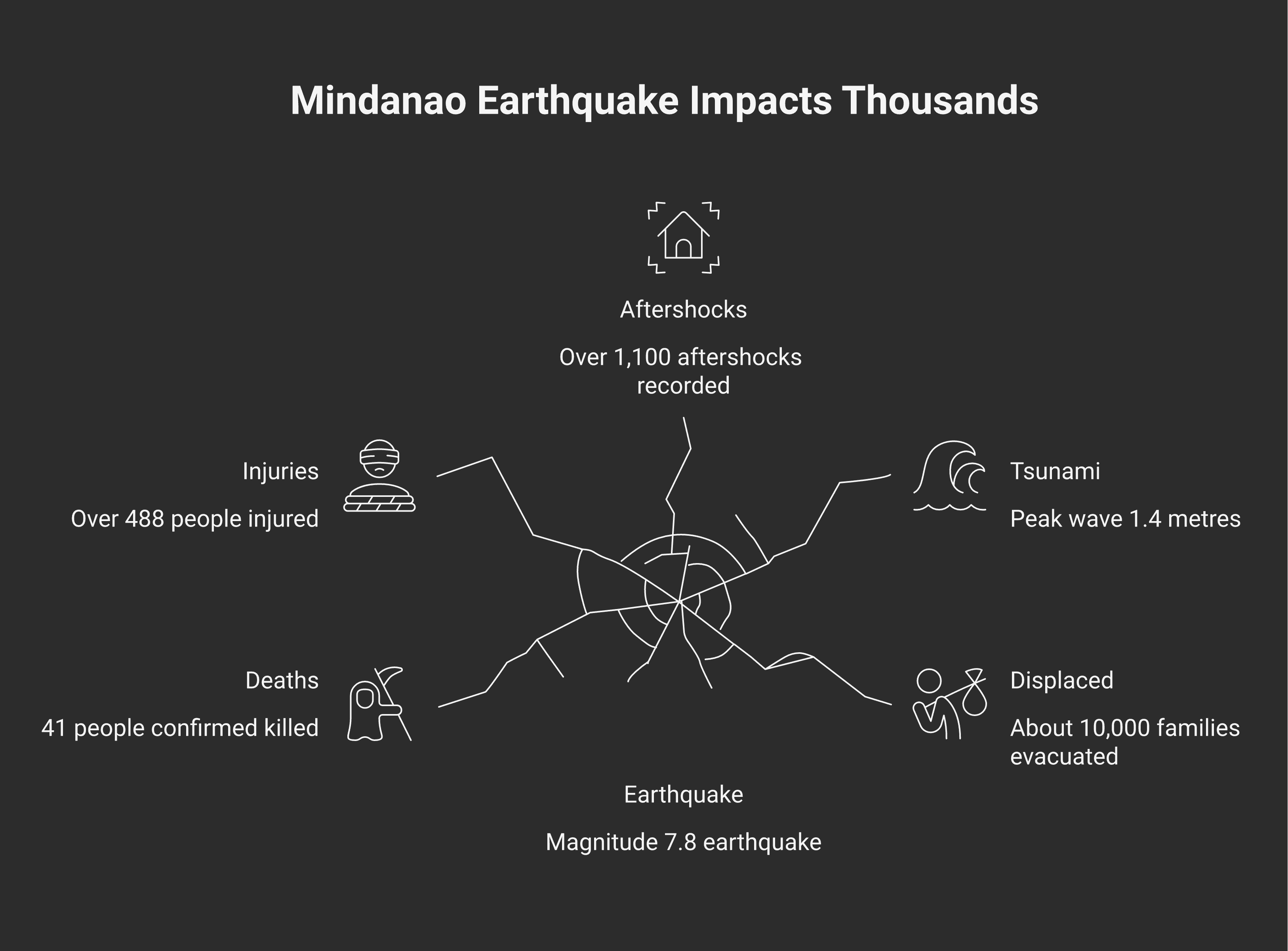
- At least 41 killed and hundreds injured. At least 41 people were killed and more than 480 injured across Mindanao — mostly by falling debris and collapsing buildings — and about 10,000 families were evacuated. Several people remain missing and the official toll is still being verified.
- A fierce aftershock sequence. PHIVOLCS had recorded more than 1,100 aftershocks by the morning of 9 June, including quakes of M6.5, M6.0 and M6.0, and warned that the sequence could continue for over a month.
- This is one of the most seismically active places on Earth. Southern Mindanao sits where several tectonic plates grind together along the Pacific Ring of Fire, making large earthquakes a recurring danger.
A major magnitude-7.8 earthquake struck off the coast of southern Mindanao in the Philippines late on 7 June 2026, generating tsunami waves of up to 1.4 m and shaking buildings across the southern provinces. At least 41 people were killed and more than 480 injured. According to the US Geological Survey (USGS), the quake hit at 23:37 UTC on 7 June (07:37 local time on 8 June) at a depth of about 55 km; the European agency EMSC also measured it at magnitude 7.8.
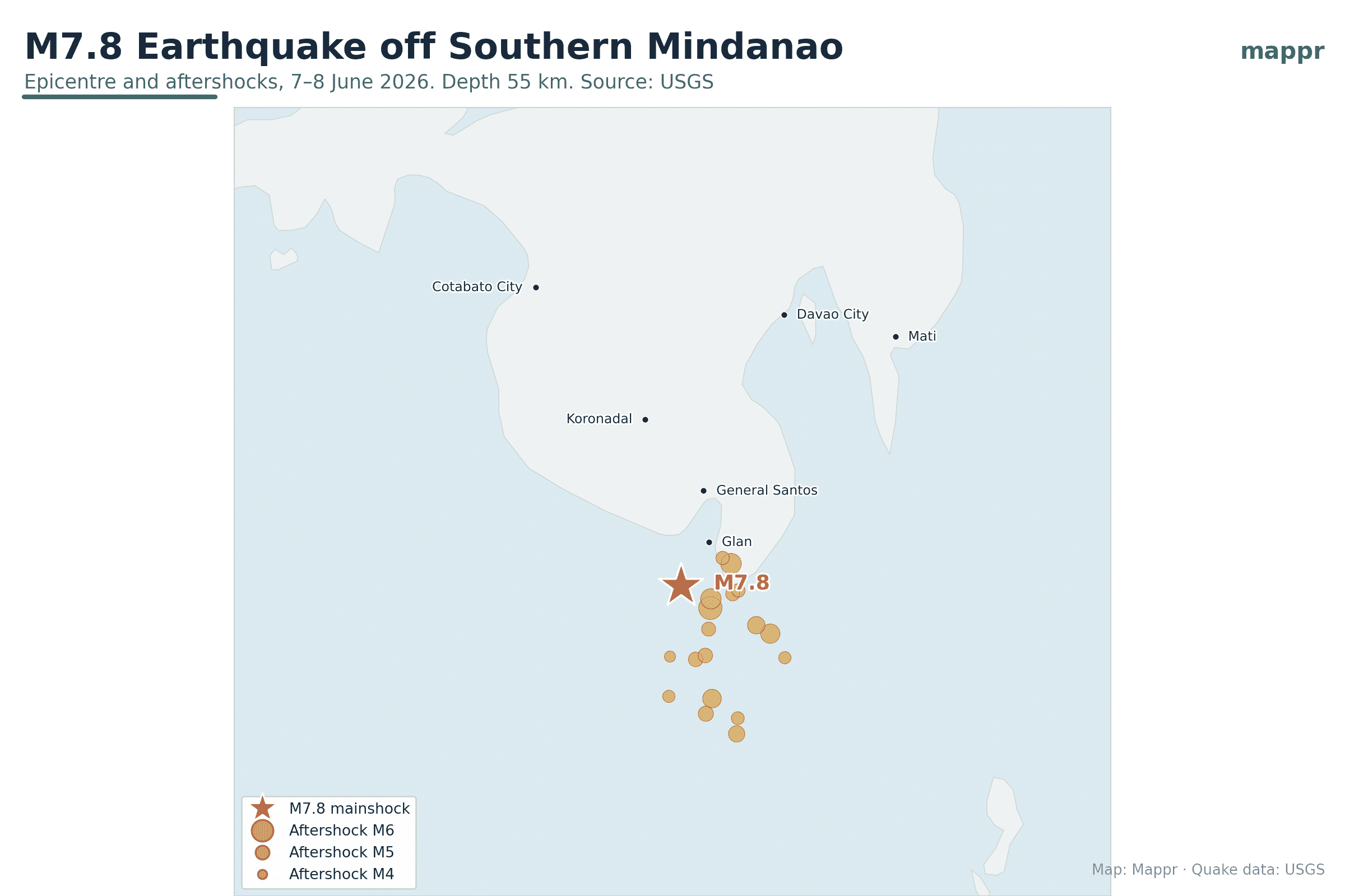
The map below shows the epicentre — offshore to the south of General Santos, near Sarangani — together with the powerful aftershock sequence that followed in the hours afterwards. This remains a developing event; casualty figures are still being verified by the Philippine authorities and may be revised.
What happened
The earthquake struck in the Celebes Sea just south of Mindanao, the largest island in the southern Philippines. The USGS reported a magnitude of 7.8 at a depth of 55.2 km; EMSC put the depth slightly shallower, at about 45 km. A quake of this size is capable of serious damage, and its moderate depth and offshore location are what allowed it to disturb the sea and generate a tsunami.
The tsunami
PHIVOLCS — the Philippine Institute of Volcanology and Seismology — said its land-based tsunami stations recorded waves of up to 1.4 m across six coastal areas of Sultan Kudarat and Sarangani, with a smaller 0.83 m wave registered across the border on Sulawesi, Indonesia. A tsunami warning was issued for several coastal provinces of Mindanao and lifted on the afternoon of 8 June. President Ferdinand Marcos Jr. directed government agencies to respond immediately, with the Office of Civil Defense and the national disaster agency (NDRRMC) coordinating the response. Waves of this size are far smaller than the catastrophic tsunamis of 2004 or 2011, but still enough to be dangerous along the immediate coast.
Damage and impact
In General Santos, the nearest major city, strong shaking collapsed buildings — including part of a fast-food restaurant — and disrupted power, communications and transport across the region. By 9 June, the national disaster agency (NDRRMC) had confirmed at least 41 deaths and more than 480 injuries, most caused by falling debris and collapsing structures, with several people still missing. About 10,000 families were evacuated across Sarangani and Sultan Kudarat as search-and-rescue teams worked through the rubble. The figures remain provisional and are likely to be revised as assessment teams reach outlying areas.
USGS
The Mainshock and Major Aftershocks
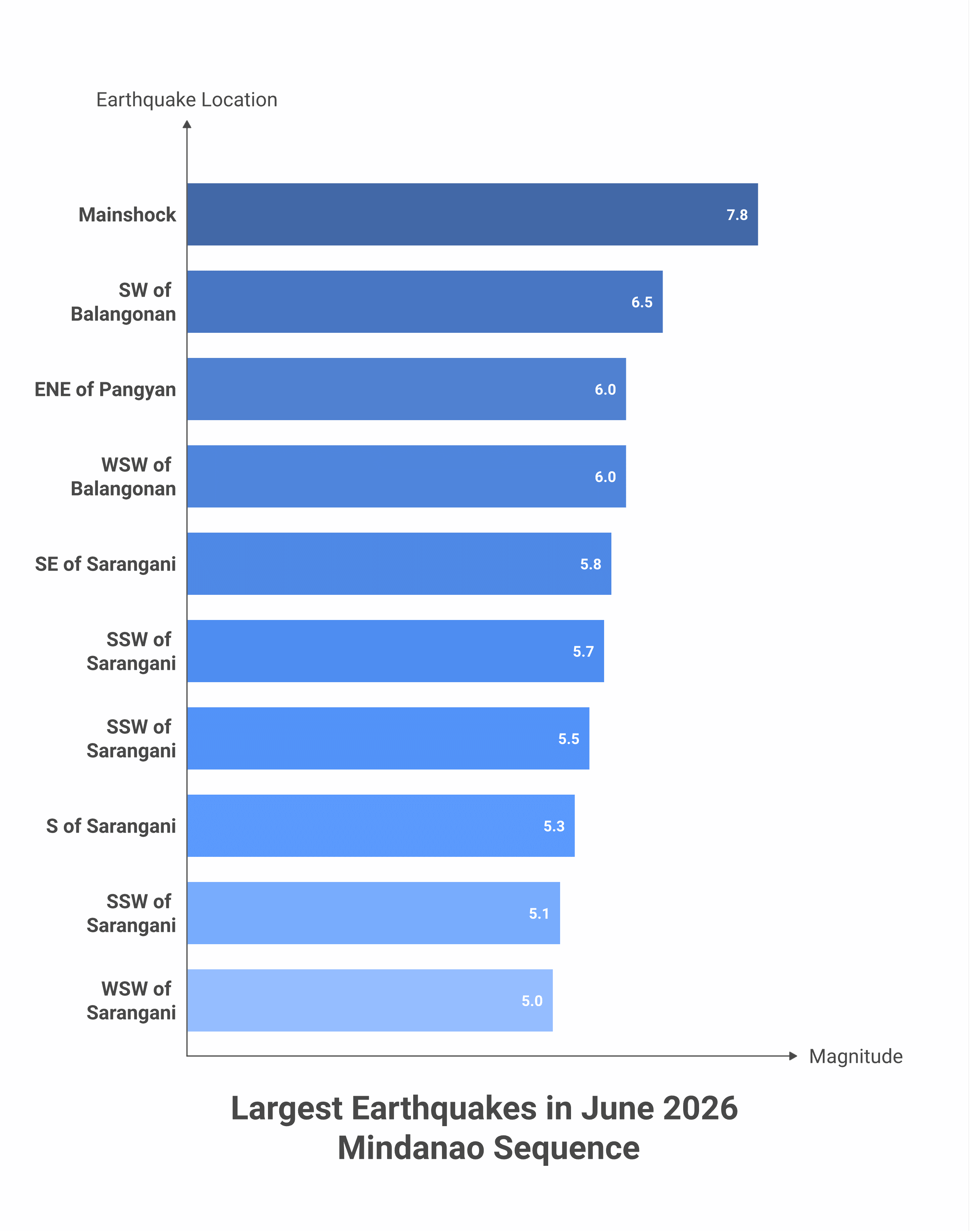
The M7.8 mainshock and aftershocks of magnitude 5.0 and above in the first hours, as recorded by the USGS.
| Location | Magnitude | Depth | Time |
|---|---|---|---|
| 26 km SW of Kablalan | M7.8 | 55 km | Jun 7, 23:37 UTC |
| 19 km SW of Balangonan | M6.5 | 66 km | Jun 8, 00:55 UTC |
| 4 km ENE of Pangyan | M6.0 | 35 km | Jun 7, 23:49 UTC |
| 16 km WSW of Balangonan | M6.0 | 82 km | Jun 7, 23:48 UTC |
| 11 km SE of Sarangani | M5.8 | 53 km | Jun 8, 00:58 UTC |
| 54 km SSW of Sarangani | M5.7 | 35 km | Jun 8, 04:46 UTC |
| 2 km SSW of Sarangani | M5.5 | 51 km | Jun 8, 05:12 UTC |
| 69 km S of Sarangani | M5.3 | 51 km | Jun 8, 04:44 UTC |
| 64 km SSW of Sarangani | M5.1 | 77 km | Jun 8, 01:10 UTC |
| 44 km WSW of Sarangani | M5.0 | 35 km | Jun 8, 04:42 UTC |
| 37 km WSW of Sarangani | M5.0 | 45 km | Jun 8, 00:53 UTC |
A fierce aftershock sequence
Big earthquakes are always followed by aftershocks, and this one was no exception. Within about an hour and a half of the mainshock, the USGS had logged aftershocks of magnitude 6.5, 6.0 and 6.0 — quakes that would each be major news on their own — followed by a steady run of magnitude-5 tremors clustered just south of Sarangani. By the morning of 9 June, PHIVOLCS had recorded more than 1,100 aftershocks and warned that the sequence could continue for over a month. Aftershocks like these pose a real danger to structures already weakened by the first shock, which is why residents were urged to stay away from damaged buildings.
Explore the earthquakes: interactive map
Use the interactive map below to zoom in and out and tap any circle for its magnitude, depth and time. The large red circle is the M7.8 mainshock; the orange circles are the aftershocks, sized by magnitude.
Why southern Mindanao is so earthquake-prone
The southern Philippines sits at one of the most complex tectonic crossroads on the planet, where the Philippine Sea Plate, the Sunda Plate and the small Molucca Sea plates collide along the Pacific Ring of Fire. Offshore trenches — including the Cotabato and Philippine trenches — mark where one slab of ocean floor is forced beneath another, storing the strain that is released in earthquakes like this one. Mindanao has a long history of powerful quakes, including a devastating M8.1 event in 1976 that killed thousands, so seismologists watch the region closely.
Earthquake magnitudes, depths, locations and the aftershock list are taken from the United States Geological Survey (USGS) earthquake catalogue. Tsunami observations and the official response are reported by PHIVOLCS and Philippine authorities, with on-the-ground detail from Reuters, AP and The Watchers. This is a developing story; figures may be revised. The map is a Mappr original.
Primary Sources:
- USGS — Earthquake catalogue (M7.8 Mindanao) – Magnitude, depth, epicentre and the full aftershock sequence.
- PHIVOLCS — Philippine Institute of Volcanology and Seismology – Tsunami wave observations and the official tsunami warning.
- NDRRMC — National Disaster Risk Reduction and Management Council – Official casualty figures, injuries and evacuation totals.
Reporting:
- The Watchers — M7.8 earthquake off southern Mindanao – Event summary, tsunami waves and early damage reports.
Image Sources:
- Map by Mappr – Epicentre and aftershock map — a Mappr original built from USGS data and Natural Earth boundaries.