Key Takeaways
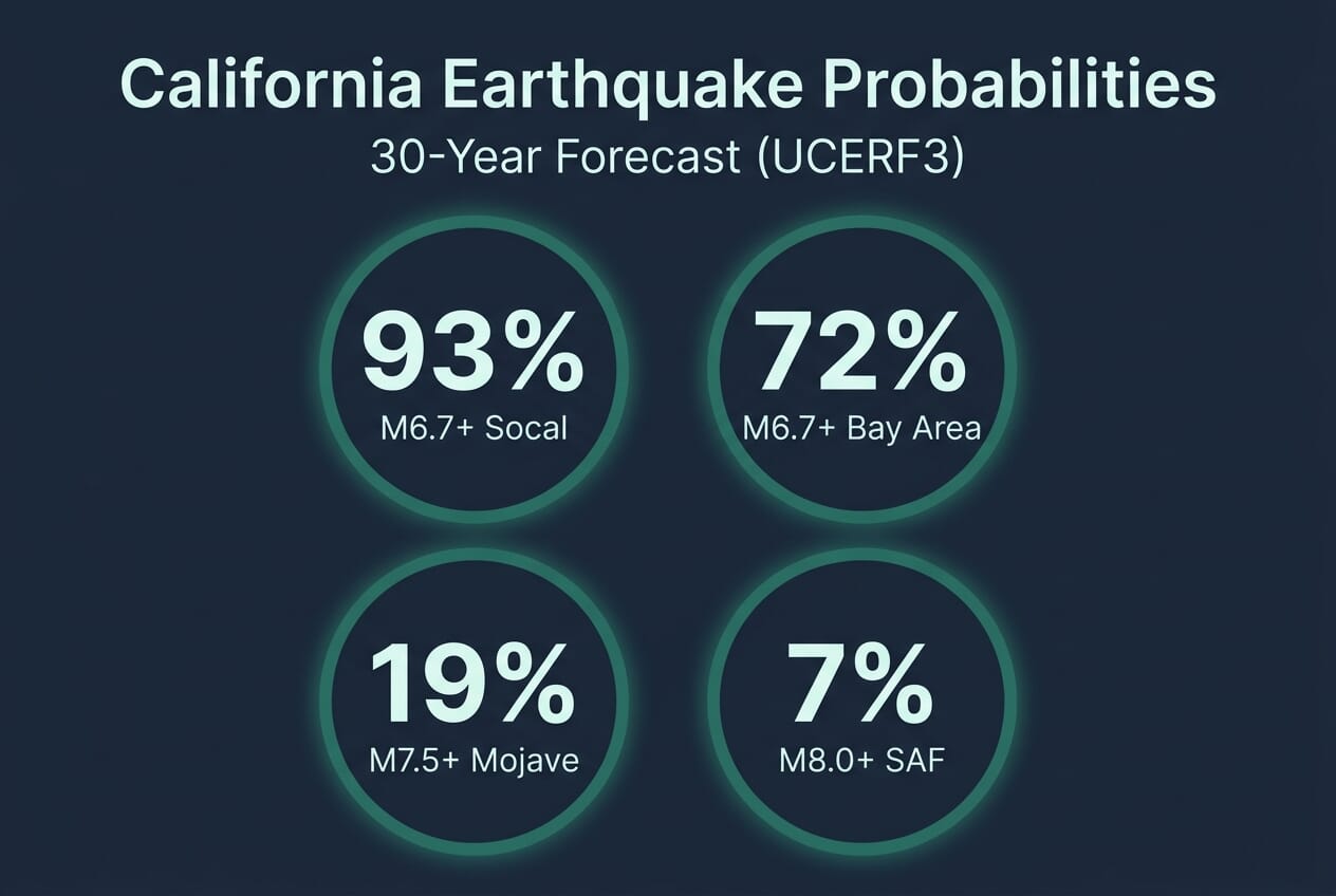
- 93% probability of a magnitude 6.7 or greater earthquake somewhere in Southern California within 30 years, per the USGS Uniform California Earthquake Rupture Forecast (UCERF3).
- The Southern Segment of the San Andreas Fault has not ruptured in over 300 years — stress modeling indicates it has accumulated sufficient energy for a major event.
- A magnitude 7.8 ShakeOut scenario on the southern fault projects ~1,800 deaths, 50,000 injuries, $200 billion in damage, and 255,000 households displaced.
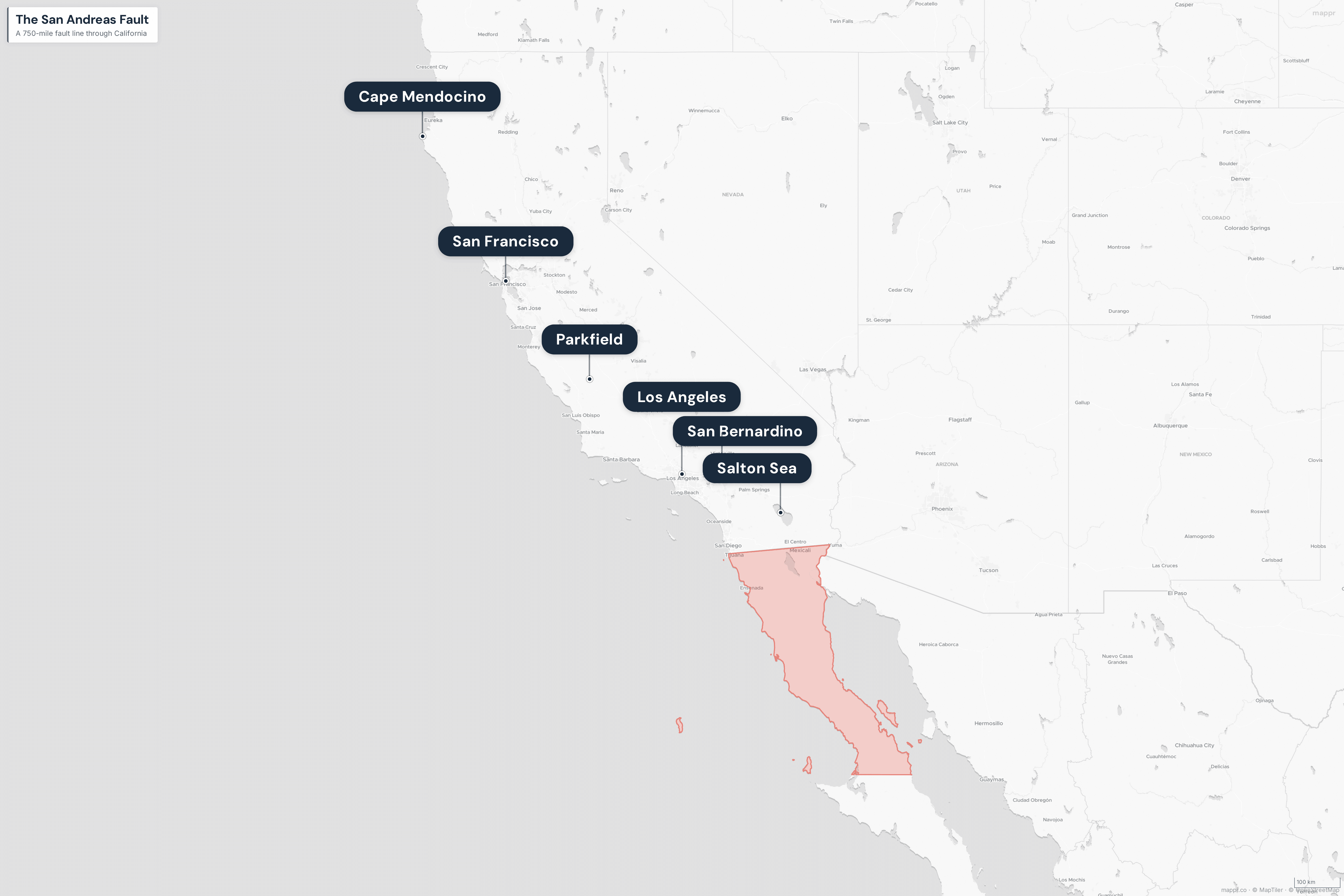
- The fault runs 750 miles (1,210 km) from Cape Mendocino to the Salton Sea, passing within 35 miles of downtown Los Angeles.
The San Andreas Fault is the 750-mile seam where the Pacific and North American tectonic plates grind past each other at roughly an inch per year. For most of its length, that movement happens quietly — either in slow aseismic creep or in small, barely noticeable tremors. But along two large locked segments in Northern and Southern California, stress has been accumulating for centuries, with no release.
The USGS Uniform California Earthquake Rupture Forecast, Version 3 (UCERF3), estimates a 93% probability of at least one magnitude 6.7 or larger earthquake somewhere in Southern California within 30 years — the timeframe running from 2014 through 2044. For the San Francisco Bay Area, the figure is 72%. Statewide, the probability of at least one M6.7+ event exceeds 99%.
What the 93% Number Actually Means
Earthquake probabilities are not predictions. They are statistical forecasts based on historical rupture intervals, measured slip rates, and the accumulated strain scientists can estimate from GPS data. A 93% chance over 30 years translates roughly to 1-in-14 odds in any given year — high enough to shape building codes and insurance markets, but far from a countdown clock.
What makes UCERF3 different from earlier forecasts is that it models the fault system as an interconnected network rather than as isolated segments. The result: the likelihood of moderate-sized earthquakes (magnitude 6.5 to 7.5) dropped slightly compared to the 2008 forecast, while the likelihood of larger multi-segment ruptures climbed. The probability of a M8.0+ earthquake somewhere on the San Andreas rose from 4.7% to 7% — small in absolute terms, but a meaningful upward revision.
Three Segments, Three Different Risks
The fault splits roughly into three behavioral zones, each with a distinct earthquake history and a different probability profile.
Northern Segment — Cape Mendocino to San Juan Bautista
This is the segment that ruptured in the 1906 San Francisco earthquake, a magnitude 7.8 event that tore approximately 270 miles of fault surface and killed over 3,000 people. The section runs offshore along the north coast, back onshore near Bolinas Lagoon, and passes directly beneath the San Francisco Peninsula before continuing south through the Santa Cruz Mountains.
The 1989 Loma Prieta earthquake (M6.9) ruptured a nearby segment but did not fully release accumulated strain on the main San Andreas. USGS estimates put the 30-year probability of a M6.7+ event in the Bay Area at 72%, with the Hayward Fault — a parallel strike-slip system — carrying a substantial share of that risk.
Central Segment — The Creeping Section
The stretch between Parkfield and Hollister is the geological oddity of the system. Instead of building stress between major earthquakes, the central segment slips more or less continuously in a process called aseismic creep. Surface features like fences, curbs, and walls built across the fault line are visibly offset over decades with no associated shaking.
Parkfield itself is a seismological laboratory. Magnitude 6.0 earthquakes have occurred there on a semi-regular basis — in 1881, 1901, 1922, 1934, 1966, and 2004 — prompting a long-running USGS experiment to capture the next rupture in detail. The creeping section acts as a buffer, largely preventing ruptures from propagating between the northern and southern locked sections.
Southern Segment — Parkfield to the Salton Sea
This is the segment that concerns seismologists most. The southern San Andreas — particularly the Carrizo, Mojave, and Coachella subsections — has not produced a major rupture since the 1857 Fort Tejon earthquake, a magnitude 7.9 event that ruptured roughly 220 miles of fault. That means stress has been accumulating for 168 years. The estimated recurrence interval at the “Big Bend” near Los Angeles is 140 to 160 years.
The Mojave segment alone carries a 19% probability of a M7.5+ earthquake within 30 years — the highest probability of any individual fault segment in California. The southernmost Coachella segment, which extends beneath the Salton Sea, has not ruptured in an even longer period and is considered particularly primed for a major event.
Who Is Actually at Risk
The fault passes within 35 miles of downtown Los Angeles and runs directly through the northern edges of San Bernardino and Riverside counties. Roughly 40 million people live in California, and the UCERF3 hazard maps place the overwhelming majority of them in zones rated moderate to severe for shaking intensity in a major event.
Cities that sit directly on or within a few miles of the fault trace include:
- Northern California: Point Reyes, Bodega Bay, Bolinas, Daly City, and the southern edge of San Francisco
- Central California: Parkfield, Hollister, and agricultural communities across San Benito County
- Southern California: Frazier Park, Gorman, Palmdale, Wrightwood, San Bernardino, Desert Hot Springs, and the Coachella Valley
Infrastructure exposure compounds the population risk. The fault crosses the California Aqueduct in multiple places, runs parallel to Interstate 5 through the Tejon Pass, and intersects or closely parallels nearly every major power transmission corridor between Los Angeles and the Central Valley. Natural gas pipelines, water mains, fiber-optic trunks, and rail lines all cross the fault — which is why the ShakeOut scenario projects an estimated 1,600 large fires from ruptured utilities alone.
The ShakeOut Scenario
The USGS and Southern California Earthquake Center have modeled a magnitude 7.8 rupture on the southern San Andreas — an earthquake similar in scale to 1857 — as the ShakeOut scenario. The modeled effects:
- Approximately 1,800 deaths and 50,000 injuries
- $200 billion in direct damage and economic losses
- 255,000 households displaced, many for months
- An estimated 1,600 large fires from utility ruptures
- Multi-day power and water outages across the Los Angeles basin
- Major disruption of interstate commerce through the Cajon and Tejon passes
The numbers are sobering, but they assume a weekday daytime event with partial warning from the ShakeAlert early warning system. A nighttime rupture or one that catches building occupants indoors during business hours could push the casualty figures substantially higher.
Historical Context: What 750 Miles of Fault Has Produced
The instrumental record is short compared to the fault’s rupture history, but the major events documented over the past two centuries give a sense of what the system is capable of:
| Year | Magnitude | Segment | Notable Impact |
|---|---|---|---|
| 1812 | ~7.0 | Southern (San Juan Capistrano) | Mission church collapse; 40+ deaths |
| 1857 | 7.9 | Southern (Fort Tejon) | ~220 miles ruptured; 2 deaths (sparse population) |
| 1906 | 7.8 | Northern (San Francisco) | ~270 miles ruptured; 3,000+ deaths |
| 1989 | 6.9 | Santa Cruz Mountains | 63 deaths; Bay Bridge collapse |
| 2004 | 6.0 | Parkfield | Instrumented rupture; no deaths |
The fault system is capable of much larger events than anything in the instrumental record. Paleoseismic trenching at sites along the southern segment has identified at least 10 major prehistoric ruptures over the past 1,500 years, with an average recurrence of roughly 150 years between events.
What Preparedness Actually Looks Like
California’s Alquist-Priolo Earthquake Fault Zoning Act prohibits new construction directly across active fault traces. Since 1971, the state has progressively tightened its building code for earthquake resilience, and retrofits to older unreinforced masonry buildings and “soft-story” apartments are ongoing in most Bay Area and Los Angeles jurisdictions.
The ShakeAlert early warning system, now fully deployed across California, Oregon, and Washington, detects the first compressional waves from a rupture and issues alerts to phones, transit systems, and industrial controls in the seconds before shaking arrives. For a major southern San Andreas rupture, Los Angeles could receive 30 to 90 seconds of warning — enough time to stop trains, close gas valves, and take cover.
Individual preparedness follows a familiar checklist: secure heavy furniture and water heaters, store at least two weeks of water and non-perishable food, keep a go-bag with medications and documents, know how to shut off gas and water, and identify meeting points with family. None of it prevents the earthquake. All of it changes what happens in the minutes and days afterward.
The Bottom Line
A major earthquake on the San Andreas Fault is, by every credible geological estimate, a near-certainty over the lifetimes of most Californians under 60. The question is not whether but when and where along the 750-mile system. The southern segment, quiet since 1857 and carrying the highest per-segment probability of any fault in the state, is the one most likely to deliver the next great California earthquake.
The 93% figure is not a threat — it is an assessment grounded in decades of data and a statement about the physical reality of a plate boundary that has moved, and will continue to move, regardless of what happens on the surface.
Sources and further reading:
Primary Sources
- USGS UCERF3 Fact Sheet – Official Uniform California Earthquake Rupture Forecast, Version 3
- Southern California Earthquake Center — UCERF3 – Research consortium documentation and methodology
- USGS Southern California Earthquake Hazards – Current hazard assessments and monitoring
- California Geological Survey — UCERF3 – State-level earthquake forecast summary
- Earthquake Country Alliance – Preparedness and scenario planning resources
Image Sources
- Featured image (AI-generated, for illustrative purposes) – Stylized aerial rendering — not a photograph of an actual fault