While it may not stand out on a World Ocean Map, the Red Sea is one of the most significant bodies of water in the world. It links Asia to Europe by way of Africa and the Middle East, enabling global trade and granting numerous advantages to the countries along its coastline.
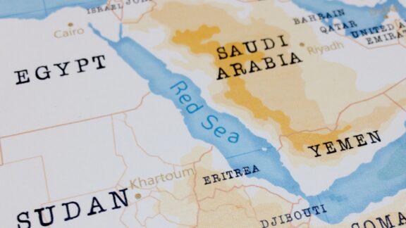
There are eight countries that border the Red Sea: Djibouti, Egypt, Eritrea, Israel, Jordan, Saudi Arabia, Sudan, and Yemen. In this post, we’ll learn more about each of these Red Sea countries and the region as a whole. Below is a map of the Red Sea countries and some of their major cities.

Djibouti

With a population of about 1.18 million (World Bank, 2025), Djibouti is the least populous country in mainland Africa. It’s also among the smallest on the continent by total area. Though small in size it may be, Djibouti plays an outsized role in the geopolitics of the Red Sea region.
Thanks to Djibouti’s strategic location near the Bab-el-Mandeb Strait, the country has influence over one of the world’s most important maritime routes. Connecting the southern end of the Red Sea with the Gulf of Aden and the Indian Ocean, the Bab-el-Mandeb Strait is a crucial part of global trade.
Djibouti’s influence over the Bab-el-Mandeb Strait is one of the reasons it hosts multiple foreign military bases, including one from the United States, one belonging to China, and others. Interest in the region from foreign countries allows Djibouti to leverage its location to foster partnerships and receive economic aid from multiple world powers.
Geographically, Djibouti is primarily part of the Ethiopian xeric grasslands and shrublands ecoregion, which is a semi-desert strip of land in the region. There are several mountain ranges in the country with elevations greater than 1,000 m (3,300 feet), and the Grand Bara Desert covers the southern part of the country.
Egypt

Home to the longest river in the world and some of the most beautiful cities in Africa, Egypt is one of the most iconic countries on the Red Sea. It’s one of the oldest countries in the world, and much of its storied history is linked to its location in Northeastern Africa along the northwest coast of the Red Sea.
Egypt’s position along the Red Sea is unique, chiefly due to the presence of the Suez Canal. The canal is an engineering marvel that connects the Mediterranean Sea to the Red Sea. It was completed in 1869 and remains one of the world’s most important waterways today, facilitating great amounts of international maritime trade.
Beyond its control of the Suez Canal, Egypt’s proximity to the Red Sea is also significant for its impact on tourism. Coastal cities like Sharm el-Sheikh and Hurghada are renowned for their beautiful beaches, coral reefs, and diving spots. Coastal tourism attracts millions of visitors every year, contributing to the Egyptian economy.
In addition to its modern-day relevance, the Red Sea coast is historically and culturally significant for Egypt. The ancient Egyptians were one of the first civilizations to navigate the Red Sea, and it served as a route for trade and exploration, connecting Egypt to other parts of Africa and the Arabian Peninsula.
Eritrea

Eritrea is located in the Horn of Africa, occupying an important position along the Red Sea’s southwestern coastline. A relatively small nation, Eritrea’s access to the sea is a critical lifeline, not only for itself but also for the region at large. It enables trade with other countries and access to fishing grounds around its Dahlak Archipelago.
The primary port city of Eritrea is Massawa, which is a key maritime gateway that serves both domestic and international shipping needs. The city has been an important port for centuries and features a mix of Italian, Egyptian, and Ottoman architecture.
The Red Sea is full of natural resources, and Eritrea is positioned to take advantage of these. Opportunities for fishing and underwater mining are some of the most beneficial, although geopolitical tensions, notably with Ethiopia, have sometimes hampered Eritrea’s ability to fully leverage them.
Additionally, Eritrea’s coastal region is home to some incredible biodiversity, with its coral reefs and marine life attracting interest from conservationists and researchers.
Israel

Israel has the smallest Red Sea coastline of any country in the region, which is focused primarily around its resort city of Eilat. Located at the country’s southernmost tip, Eilat serves as a vital port and a popular tourist destination. It’s known for its stunning coral reefs, luxury resorts, and water sports, drawing tourists from around the world.
Eilat’s port historically served as Israel’s maritime gateway to trading partners in Asia and Africa, but it permanently ceased commercial operations in July 2025 after Houthi attacks on Red Sea shipping, which began in late 2023, collapsed its traffic and drove it into bankruptcy. Israel’s access to the Red Sea nonetheless remains strategically significant as an alternate maritime route to the Mediterranean.
Maintaining a naval presence in the Red Sea is also part of Israel’s overall defense strategy, protecting its maritime interests and monitoring naval activities in the area. This is a key aspect of the country’s military strategy, especially given the volatile geopolitics of the Middle East.
Israel and Jordan both share the northernmost end of the Gulf of Aqaba, and the peace treaty between the two countries allows their respective ports to exist in close proximity.
Jordan

Located along Israel’s eastern border is the country of Jordan, whose access to the Red Sea is limited to a narrow strip of coastline around its port city of Aqaba. While small in size, the city of Aqaba and its surrounding land hold immense economic and strategic value for Jordan.
Economically, Aqaba is valuable both as a seaport and as a major tourist destination. The city’s port, which is undergoing a $242 million expansion slated for completion before 2031, enables Jordan to trade with markets in Asia, Africa, and beyond.
As a tourist destination, Aqab attracts millions of visitors from all over the world seeking to enjoy its pristine beaches or explore the underwater wonders of the Red Sea. Scuba diving, snorkeling, and water sports are all popular activities that contribute to the local economy.
Jordan’s access to the Red Sea is also of great strategic importance. The country is otherwise landlocked, and its port at Aqaba allows the Jordanian Navy to operate in the sea with access to connected bodies of water like the Mediterranean Sea and the Arabian Sea.
Saudi Arabia

The biggest country on the Arabian Peninsula, Saudi Arabia also has the longest Red Sea coastline and is a major political and economic force in the region. With terrain that is mostly arid desert, lowland, steppe, and mountains, Saudi Arabia is the only country to have coastlines on the Red Sea and the Persian Gulf.
Saudi Arabia’s extensive Red Sea coast offers the country many strategic and economic opportunities. In terms of geopolitics and defense, the country’s access to the Red Sea enables it to secure maritime routes, often in coordination with other Red Sea countries, to facilitate the trade and safe passage of oil and other commodities.
An especially ambitious undertaking in Saudi Arabia’s Red Sea region is NEOM, a planned mega-city that aims to serve as a global hub for investment, innovation, and commerce. This venture is part of Saudi Arabia’s efforts to diversify its economy beyond oil and to leverage the Red Sea’s potential for sectors like tourism, renewable energy, and logistics.
Sudan

Sudan is located in East Africa and has a coastline along the Red Sea that is 530 miles (853 km) long. Composed primarily of flat plains separated by several mountain ranges, Sudan is among the largest countries in the world and the third largest in Africa. Its access to the Red Sea holds great economic and strategic importance for the country.
The nation’s primary maritime gateway is the port city of Port Sudan, crucial for the import and export of goods with other nations. As Sudan continues to struggle with internal conflict and cope with international sanctions, revitalizing and expanding its port facilities has become a key focus to stimulate economic growth.
There is potential for tourism along Sudan’s Red Sea coast, although this sector remains largely underdeveloped due to the country’s lack of infrastructure and ongoing political instability.
Yemen

Yemen’s location at the southwestern end of the Arabian Peninsula gives it access to the Red Sea, the Gulf of Aden, and the Bab-el-Mandeb Strait that connects them. This location is highly valuable in terms of geopolitics and access to natural resources, though Yemen hasn’t been able to take full advantage due to the country’s ongoing civil war.
Although there is massive potential for tourism along Yemen’s Red Sea coastal area, the country’s political stability has severely impacted the sector. Scenic beaches and potential diving locations are some of what the area has to offer.
The Red Sea could also offer Yemen access to the fishing industry, which would provide an additional source of food and income for the country, but this sector has been limited by political upheaval as well.
Access to the Red Sea is so valuable that it is playing a major role in the Yemen conflict. Since late 2023, Houthi forces have attacked commercial shipping in the Red Sea and the Bab-el-Mandeb Strait, forcing many carriers to reroute around the Cape of Good Hope and sharply reducing traffic through the Suez Canal. The crisis has reshaped trade and security dynamics for every country on this map.
More About the Red Sea: FAQs
Why is it called the Red Sea?
The Red Sea’s name is thought to come from the seasonal blooms of a type of algae called Trichodesmium erythraeum, which can give the water a reddish-brown hue.
Is the Red Sea actually red?
No, the Red Sea is not red. Its waters are typically a deep blue or turquoise.
What is the significance of the Suez Canal?
The Suez Canal in Egypt connects the Red Sea to the Mediterranean Sea. It is one of the world’s most crucial waterways, enabling the shortest maritime route between Europe and the Indian and western Pacific oceans.
What kind of marine life is found in the Red Sea?
The Red Sea is home to diverse marine life, including over 1,000 species of fish and hundreds of species of coral.
Are there sharks in the Red Sea?
Yes, several species of sharks can be found in the Red Sea, including the Grey Reef Shark, Hammerhead Shark, and White-tip Reef Shark, although shark attacks are relatively rare.


- Map of the Red Sea Region — © Peter Hermes Furian/Shutterstock
- Coastal Activity in Tadjoura, Djibouti with Locals and Boats — © Matyas Rehak/Shutterstock
- Panoramic View of a Coastal Resort Town with Pier and Mountains in the Background — © Nataliabiruk/Shutterstock
- Serene Waterfront View of Massawa, Eritrea Under Approaching Storm Clouds — © Andy Mock/Shutterstock
- Sunny Day at a Beach in Eilat, Israel with a Wooden Pier Extending into Clear Blue Waters — © Marcin Krzyzak/Shutterstock
- Aerial View of Aqaba Cityscape at Sunset with Red Sea and Mountains in the Background — © trabantos/Shutterstock
- Aerial View of Jeddah Sea Shore and Cityscape at Sunset — © Sainuddeen Alanthi/Shutterstock
- Crane Overlooking the Blue Waters at Port Sudan — © Danilo Strino/Shutterstock
- Colorful Fishing Boats at a Busy Fish Market in Hodeida, Yemen — © Sergey-73/Shutterstock