Norway is divided into 15 counties (Norwegian: fylker), a structure in force since 1 January 2024. The counties are further divided into 357 municipalities. If that number looks unfamiliar, you are not alone: Norway has redrawn its county map twice in five years, and this page reflects the current, official structure.
Here is our up-to-date map of the 15 counties of Norway:
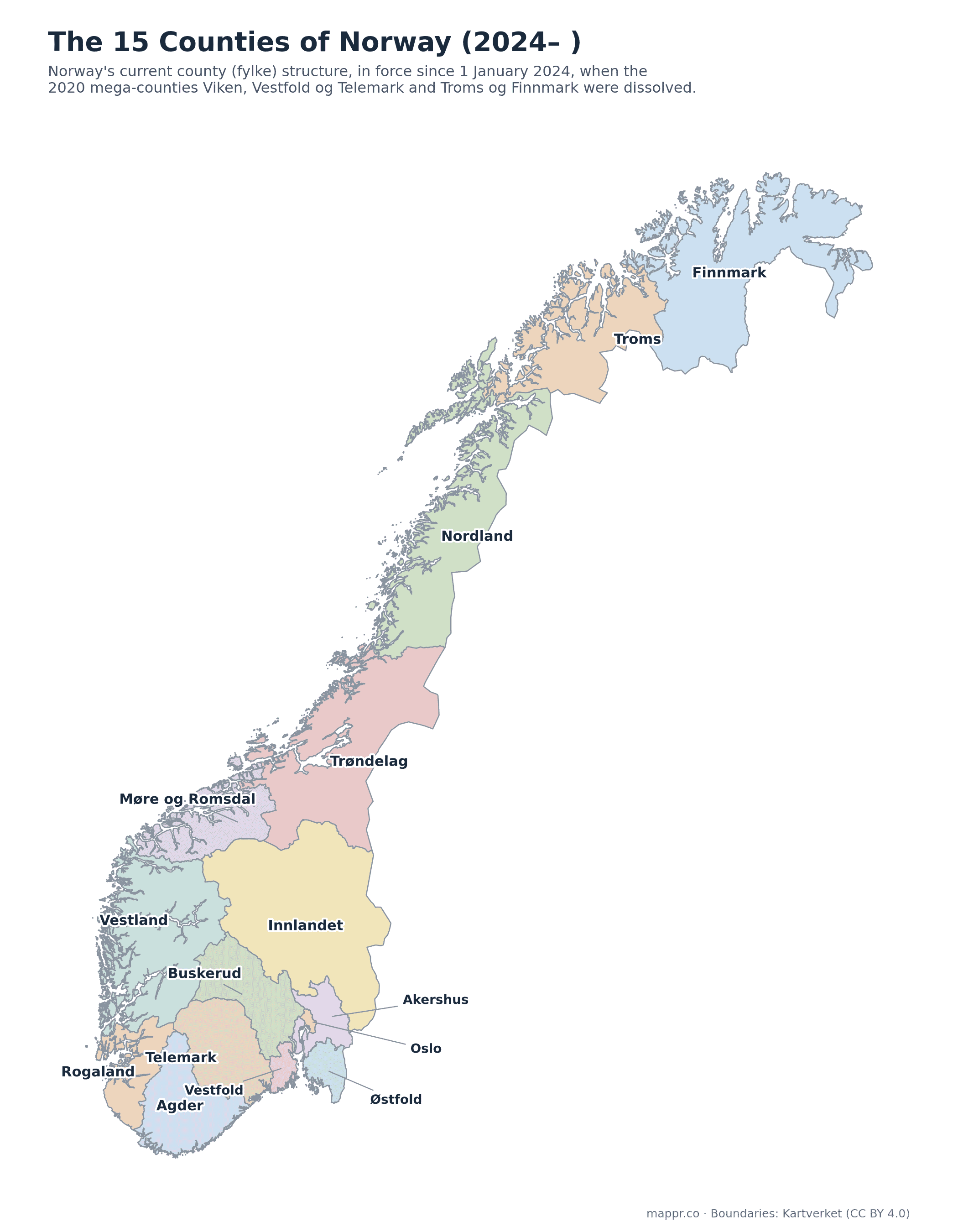
The 15 counties are:
- Agder
- Akershus
- Buskerud
- Finnmark
- Innlandet
- Møre og Romsdal
- Nordland
- Oslo
- Rogaland
- Telemark
- Troms
- Trøndelag
- Vestfold
- Vestland
- Østfold
The 15 counties, one by one
Oslo is both the national capital and a county in its own right; the other 14 counties each have their own administrative centre. Populations are rounded figures based on Statistics Norway (2025).
Østfold
- Administrative centre: Sarpsborg
- Area: roughly 4,000 km² · Population: about 310,000
- Norway’s southeastern gateway to Sweden, along the eastern shore of the Oslofjord. Fredrikstad is its largest city.
Akershus
- Administrative centre: Oslo
- Area: roughly 5,900 km² · Population: about 750,000
- The populous ring around the capital and Norway’s second-most populous county, home to Oslo’s airport at Gardermoen.
Oslo
- Administrative centre: Oslo (the capital itself)
- Area: roughly 454 km² · Population: about 720,000
- The capital is both a city and a county of its own, and Norway’s political, economic and cultural centre.
Innlandet
- Administrative centre: Hamar
- Area: roughly 52,000 km² · Population: about 370,000
- Norway’s only county with no coastline, covering the great inland valleys and mountains, including Lillehammer of Olympic fame.
Buskerud
- Administrative centre: Drammen
- Area: roughly 14,900 km² · Population: about 270,000
- Stretches from the Drammensfjord deep into the mountains, taking in the ski resorts of Geilo and Hemsedal.
Vestfold
- Administrative centre: Tønsberg
- Area: roughly 2,200 km² · Population: about 260,000
- Norway’s smallest mainland county after Oslo, a dense coastal strip on the western Oslofjord. Tønsberg is often called Norway’s oldest town.
Telemark
- Administrative centre: Skien
- Area: roughly 15,300 km² · Population: about 180,000
- Famous as the cradle of skiing, running from the coast at Kragerø up to the Hardangervidda plateau.
Agder
- Administrative centre: Kristiansand
- Area: roughly 16,400 km² · Population: about 320,000
- Norway’s southern tip, merged from the two former Agder counties in 2020 and kept intact in 2024. Its skerry-lined coast is Norway’s summer playground.
Rogaland
- Administrative centre: Stavanger
- Area: roughly 9,400 km² · Population: about 500,000
- The heart of Norway’s oil industry around Stavanger, with Preikestolen (Pulpit Rock) among its fjord landmarks.
Vestland
- Administrative centre: Bergen
- Area: roughly 33,900 km² · Population: about 650,000
- Created in 2020 from Hordaland and Sogn og Fjordane and unchanged in 2024, it holds Bergen, the Sognefjord and much of fjord Norway.
Møre og Romsdal
- Administrative centre: Molde
- Area: roughly 14,400 km² · Population: about 270,000
- Fjord country between the west and the north, home to Ålesund’s Art Nouveau townscape and the Atlantic Ocean Road.
Trøndelag
- Administrative centre: Steinkjer
- Area: roughly 42,200 km² · Population: about 490,000
- Mid-Norway around the Trondheimsfjord, merged from two counties in 2018 and untouched since. Trondheim is its largest city, Steinkjer its administrative centre.
Nordland
- Administrative centre: Bodø
- Area: roughly 38,500 km² · Population: about 240,000
- A thousand kilometres of coast above and below the Arctic Circle, including Lofoten and Vesterålen.
Troms
- Administrative centre: Tromsø
- Area: roughly 26,000 km² · Population: about 170,000
- High-Arctic fjord country around Tromsø, the ‘Paris of the North’ and a hub for northern-lights tourism.
Finnmark
- Administrative centre: Vadsø
- Area: roughly 48,600 km² · Population: about 75,000
- Norway’s largest and least-populated county, on the roof of Europe. It borders Russia and Finland and is the heartland of the Sámi people.
Why Norway keeps redrawing its counties
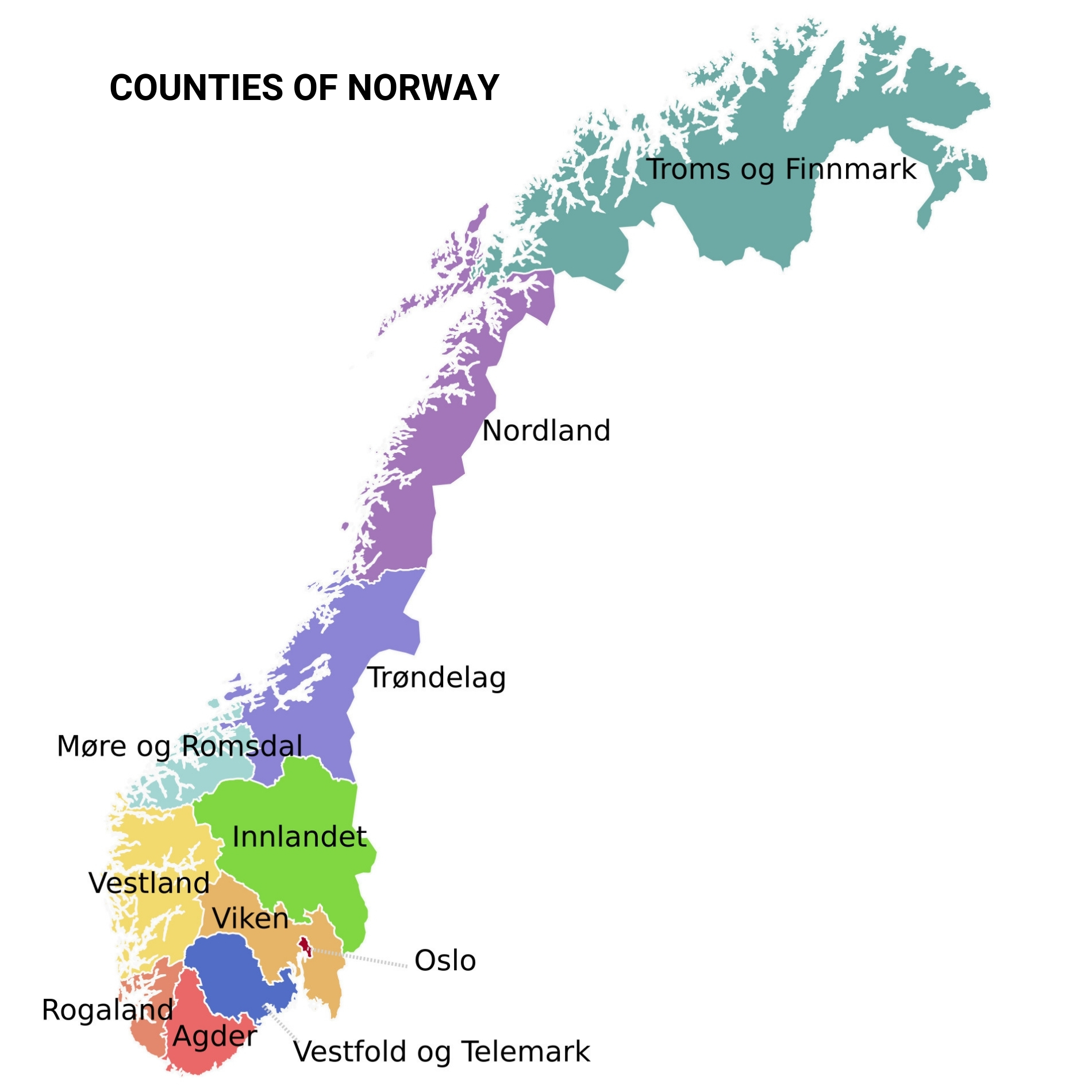
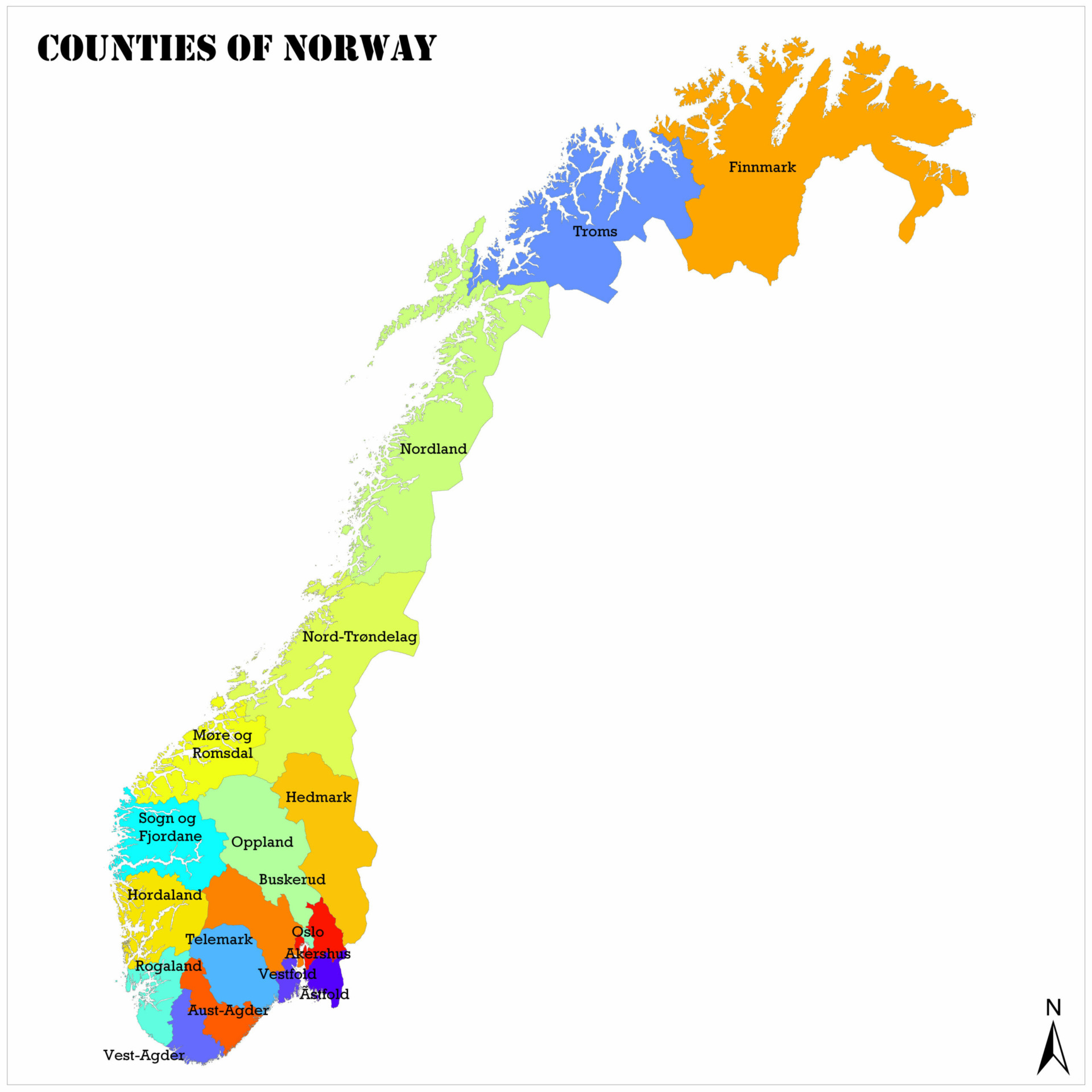
For decades Norway had 19 counties (18 plus Oslo). A sweeping regional reform then merged them into just 11 mega-counties in 2020, creating giants like Viken, which wrapped around Oslo and was home to a quarter of all Norwegians. The mergers were deeply unpopular in several regions, and after the 2021 election the process went into reverse: on 1 January 2024, Viken, Vestfold og Telemark and Troms og Finnmark were dissolved, and Norway settled on today’s 15 counties. Three of the 2020 mergers survived, however: Innlandet, Vestland, Agder and the older 2018 merger of Trøndelag remain in place.
Historical county maps of Norway
Because so much genealogy, statistics and literature references the older structures, we keep our previous maps available here.
The 11 counties of 2020–2023 (the short-lived mega-county era, with Viken, Vestfold og Telemark and Troms og Finnmark):
The classic 18+1 county structure (in force until the reforms began in 2018, and still the frame of reference for most family history):
Related: Colors and the Meaning of the Norway Flag