
Key Takeaways
- A Category 5 is sitting just off Mexico. Hurricane Polo packs 160 mph (260 km/h) winds and a 923 mb core about 150 miles (240 km) WSW of Zihuatanejo and pulling away. The NHC now curves it north toward Baja California early next week.
- It went from tropical storm to Cat 5 in about a day. A NOAA plane measured 892 mb, second only to Patricia (2015) in eastern Pacific records, with peak winds near 180 mph (285 km/h). El Niño-warmed Pacific water is the fuel.
- Rain, not wind, is the main threat to land. 4 to 6 inches (100-150 mm), locally 8 inches (200 mm), on coastal Guerrero. On the steep Sierra Madre del Sur slopes, that means flash floods and mudslides.
- Hawaii is watching a different storm. Tropical Storm Nolo, forecast to become a major hurricane, has the Big Island under a Hurricane Watch with 15-20 inches of rain forecast, locally 35 inches.
The eastern Pacific produced a monster this week. Hurricane Polo exploded from a tropical storm into a Category 5 hurricane in roughly 24 hours, briefly peaking near 180 mph (285 km/h), and is now sliding along Mexico’s southwestern coast just offshore of Guerrero, Michoacán, and Colima.
The good news: the forecast keeps Polo’s catastrophic core over water. The bad news: it doesn’t take a landfall to kill people here. The coastline behind Acapulco and Zihuatanejo rises almost straight out of the sea, and tropical rain falling on those slopes is how Mexico’s Pacific coast gets its deadliest disasters. And while all eyes are on Polo, a separate storm named Nolo is curling toward Hawaii.
STORM-STATUS · Sep 24, 2026 (NHC Advisory 15, 0900 UTC): Polo is still a Category 5 hurricane with 160 mph (260 km/h) winds and a 923 mb core, centered about 150 mi (240 km) WSW of Zihuatanejo and moving NW at 9 mph (15 km/h). The core is now pulling away from the Guerrero coast.
A Tropical Storm Warning still runs from Tecpan de Galeana to Manzanillo, with a watch west to Playa Perula. Mexico suspended classes across coastal Guerrero and six Michoacán municipalities and closed ports from Oaxaca to Colima.
In Hawaii, Tropical Storm Nolo (45 mph) remains under a Hurricane Watch for Hawaii County and should be a hurricane by Thursday night. Figures will change; check the National Hurricane Center for the latest advisory.
A Category 5, Just Offshore
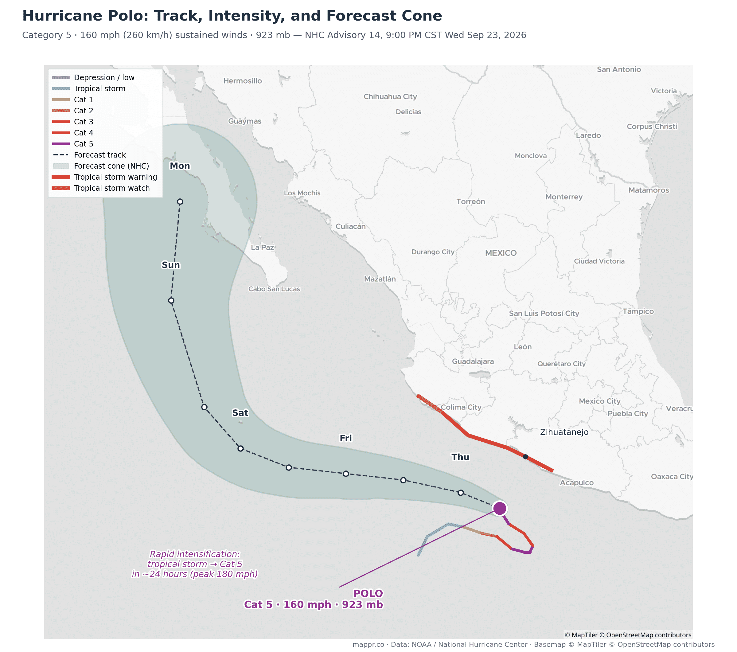
As of the National Hurricane Center’s 3:00 AM CST advisory on Thursday, Polo still carried maximum sustained winds of 160 mph (260 km/h) with a minimum central pressure of 923 mb. Forecasters expect small fluctuations in strength today before rising wind shear starts to erode the storm this weekend.
The center has moved to about 150 miles (240 km) west-southwest of Zihuatanejo and is tracking northwest at 9 mph (15 km/h), faster than Wednesday’s crawl. That acceleration helps Guerrero: it shortens the time the rain shield sits over the same slopes.
The official forecast takes Polo west-northwest through Friday, keeping the core offshore, then bends it north toward the Baja California peninsula early next week as it weakens. Hurricane-force winds extend about 40 miles (65 km) from the center; tropical-storm-force winds now reach 125 miles (200 km).
That outer wind field is what clips the coast: a Tropical Storm Warning runs from Tecpan de Galeana to Manzanillo, with a watch extending west to Playa Perula. The track also carries Polo just west of Socorro Island, a Mexican outpost of roughly 250 people in the Revillagigedo archipelago.
From Tropical Storm to Category 5 in a Day
Polo’s intensification was violent even by 2026 standards. NHC best-track data shows it at tropical-storm strength (40 kt) roughly a day before it hit Category 5 (140 kt), briefly touching 155 kt, about 180 mph. On the track map above, that’s the tight loop where the line jumps from blue to purple.
The numbers behind that jump are historic. A NOAA reconnaissance plane measured a central pressure of 892 mb on Tuesday, the second-lowest ever recorded in the eastern Pacific, behind only Hurricane Patricia’s 872 mb in 2015.
Only nine of the roughly 1,088 hurricanes logged in the basin since 1950 have dropped below 900 mb. Polo’s 180 mph peak winds rank third on record here, tied with Hurricane Rick in 2009 and behind Patricia and Linda (1997).
The NHC called the intensification “truly remarkable.” Winds climbed from 45 mph early Monday to 150 mph by Tuesday morning, far beyond the 35 mph in 24 hours that defines rapid intensification.
The fuel is no mystery. El Niño conditions have left the eastern Pacific running warmer than normal, and forecasters have pointed to exactly this pattern to explain a hyperactive Pacific season, from Hawaii’s repeated storm threats to monsters like Polo. Warm water deep below the surface means a storm can churn without cooling its own engine, and slow-moving storms like Polo normally do exactly that.
The Rain Is the Real Danger
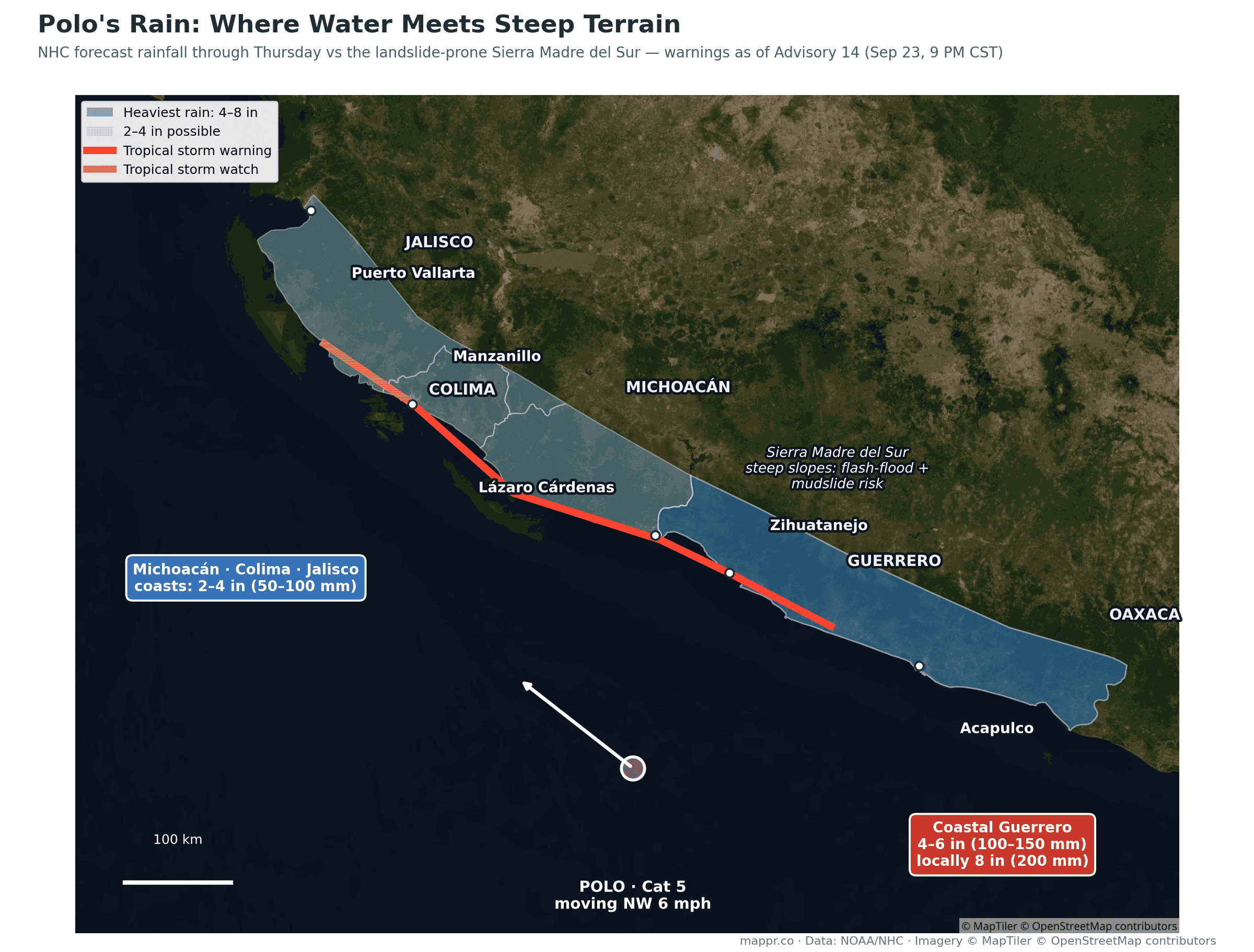
The NHC expects 4 to 6 inches (100-150 mm) of rain on coastal Guerrero through Thursday, with isolated totals up to 8 inches (200 mm). The coasts of Michoacán, Colima, and Jalisco should see 2 to 4 inches (50-100 mm).
Those numbers sound modest next to Hawaii’s forecast below, but geography multiplies them. The Sierra Madre del Sur rises to over 3,000 meters within about 100 km of the shoreline. Rain that falls on those slopes doesn’t spread out; it funnels into steep canyons and arrives in towns as flash floods and debris flows. The NHC’s own advisory flags “life-threatening flooding and mudslides, especially in areas of steep terrain.”
This is the same physical-geography trap that made Hurricane Otis so deadly in Acapulco in 2023 and that turns even offshore storms into killers here. Swells from Polo will also pound the coast for days, spreading north to Baja California Sur by the weekend with dangerous surf and rip currents.
Mexico Shuts Down the Coast
Guerrero suspended public and private school classes on Thursday across the Costa Grande, Acapulco, Costa Chica, Sierra and Montaña regions. Michoacán did the same in Aquila, Coahuayana, Arteaga, Tumbiscatío, Chinicuila and Coalcomán.
The navy (Semar) closed Acapulco, Puerto Marqués and Zihuatanejo to all navigation and shut smaller craft out of ports in Colima, Michoacán and Oaxaca. Plan Marina is in its prevention phase, and about 1,700 soldiers are deployed along the Michoacán coast.
No deaths or major damage had been reported as of Thursday morning. Oaxaca’s civil protection agency logged 2 to 3 meter surf around Puerto Escondido and Pochutla, and President Claudia Sheinbaum said experts do not expect Polo to touch land.
Polo’s Moisture Is Already Flooding New Mexico
The storm’s reach runs well past Mexico. Tropical moisture streaming north ahead of Polo helped trigger a Flash Flood Emergency in Mora County, New Mexico, earlier this week, with flash flood warnings later reaching Las Cruces and El Paso.
Three Storms, One Ocean
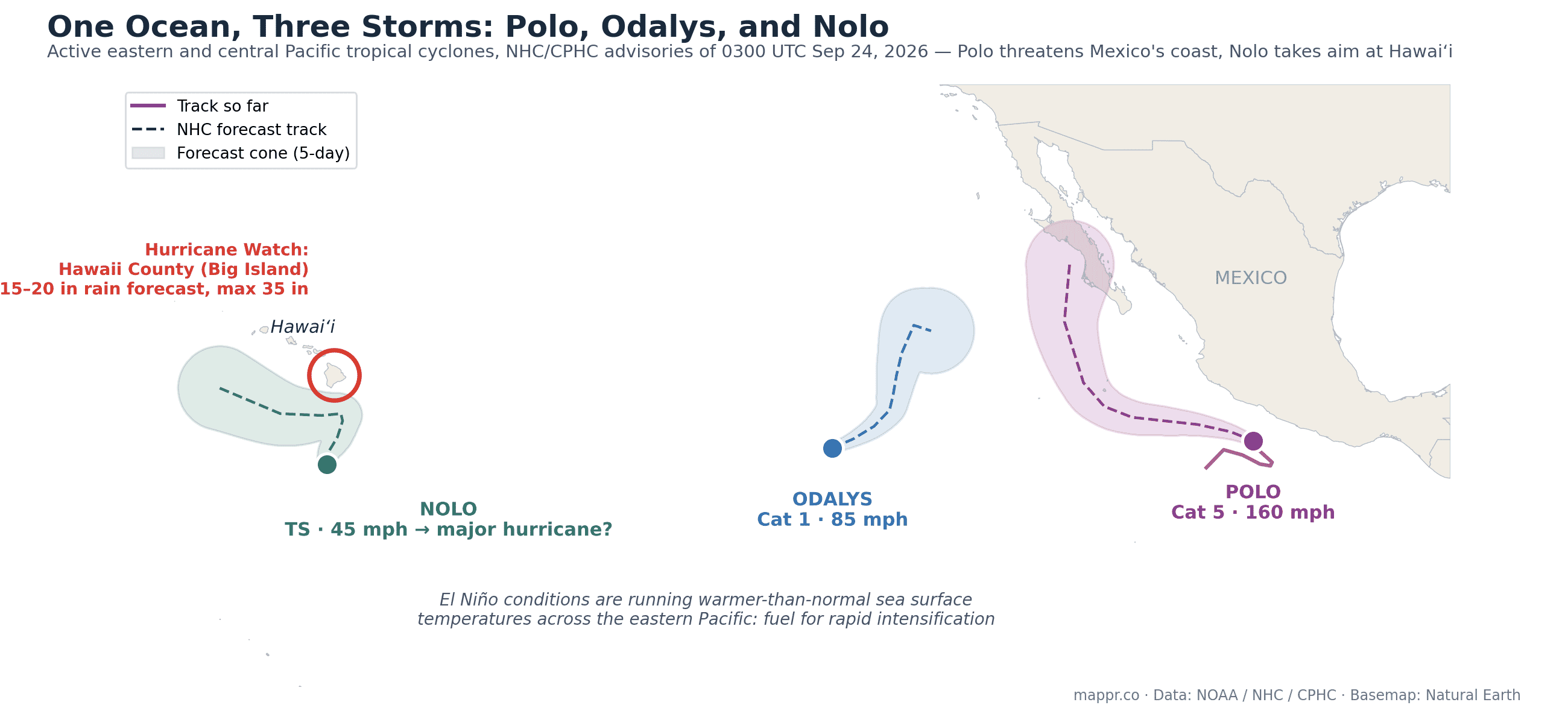
Polo isn’t alone out there. Hurricane Odalys has reached 85 mph (140 km/h) about 1,145 miles (1,845 km) west-southwest of Baja California’s southern tip, with no threat to land and weakening due late this week.
The storm that matters is Tropical Storm Nolo, about 295 miles (480 km) south of Hawaii’s South Point and 475 miles (765 km) south-southeast of Honolulu.
Nolo is forecast to turn sharply north on Thursday, become a hurricane by Thursday night and reach major-hurricane strength on Saturday, passing about 85 nautical miles (100 mi / 160 km) south of the Big Island. A Hurricane Watch is in effect for Hawaii County, the state’s third hurricane threat of the 2026 season.
Forecasters flag real uncertainty over exactly when and where that turn happens. The European model sits on the closer side of the guidance, which would bring the core nearer to Hawaii Island than the official track.
The rainfall forecast there is extraordinary: 15 to 20 inches (380-500 mm) across the Big Island, with maximum totals up to 35 inches (890 mm), plus 5 to 10 inches on Maui and a 1-3 ft storm surge on Hawaii County’s coast. Forecasters call the flooding potential catastrophic. Hawaii’s volcanic slopes concentrate runoff the same way Guerrero’s sierra does, which is why the islands flood so violently under slow tropical rain.
A Flood Watch is already up for Hawaii Island and Maui County, running through 6 p.m. Saturday. Winds of 74 to 100 mph are possible on Hawaii Island from Friday night, depending on how close Nolo’s center tracks.
What Happens Next
For Mexico, the window is short: the heaviest rain falls through Thursday, and by Friday Polo should be pulling away to the west-northwest while remaining a powerful major hurricane over open water. Watch for river rises and slope failures in Guerrero a day or two after the rain peaks; mudslides lag the rainfall.
Then comes a second act. The NHC’s five-day track now curves Polo north toward Baja California Sur, putting the center near the peninsula around Tuesday at roughly 90 mph (145 km/h). Models disagree on whether it ever makes a true landfall, so treat that as a watch item rather than a forecast.
For Hawaii, the dangerous window is Friday night through the weekend as Nolo closes in. If it verifies as a major hurricane near the Big Island, it would be one of the most serious threats to the state in years, on the heels of the worst flooding in two decades this March.
We’ll keep the status box at the top of this post updated as advisories come in.
Data and reporting for this article come from the following sources: