Key Takeaways
- Very severe cyclonic storm. Cyclone Arnab is intensifying in the Bay of Bengal and tracking toward the eastern Indian coast.
- Landfall on the Andhra coast. Expected on the morning of 28 October (forenoon IST) between Bapatla and Visakhapatnam in Andhra Pradesh, close to Yanam.
- 115 to 125 km/h winds. The IMD forecasts sustained winds of 115–125 km/h gusting to 140, a storm surge of about 1 to 1.5 m, and very heavy rain.
- Red alerts and mass evacuations. Red alerts are up for Andhra Pradesh and Odisha. More than 89,000 people have been evacuated, schools are shut, dozens of trains cancelled and NDRF teams deployed.
- Live map. The tracker below updates automatically as new advisories are issued.
A powerful tropical cyclone, named Arnab, is churning across the Bay of Bengal and closing in on the eastern coast of India. The India Meteorological Department (IMD) has classified it as a very severe cyclonic storm and expects it to make landfall on the morning of 28 October, forenoon India time, along the Andhra Pradesh coast between Bapatla and Visakhapatnam, close to the town of Yanam.
The system strengthened quickly after forming earlier this week, and it now dominates the news across coastal India as more than 89,000 people are moved to safety. This page carries a live map of the storm’s position, its forecast track and the cone of uncertainty, alongside the key details on when and where it is expected to hit.
Live tracker: where Cyclone Arnab is now
The map below shows the current centre of Cyclone Arnab, its track so far, the official forecast track and the cone of uncertainty around it. It refreshes automatically as new advisories are issued, so it is worth checking back as the storm approaches the coast.
Live position and track via GDACS, which relays JTWC and IMD guidance. Wind and landfall figures follow the IMD’s official bulletins. If the map shows no active system, Arnab has made landfall and weakened below cyclone strength.
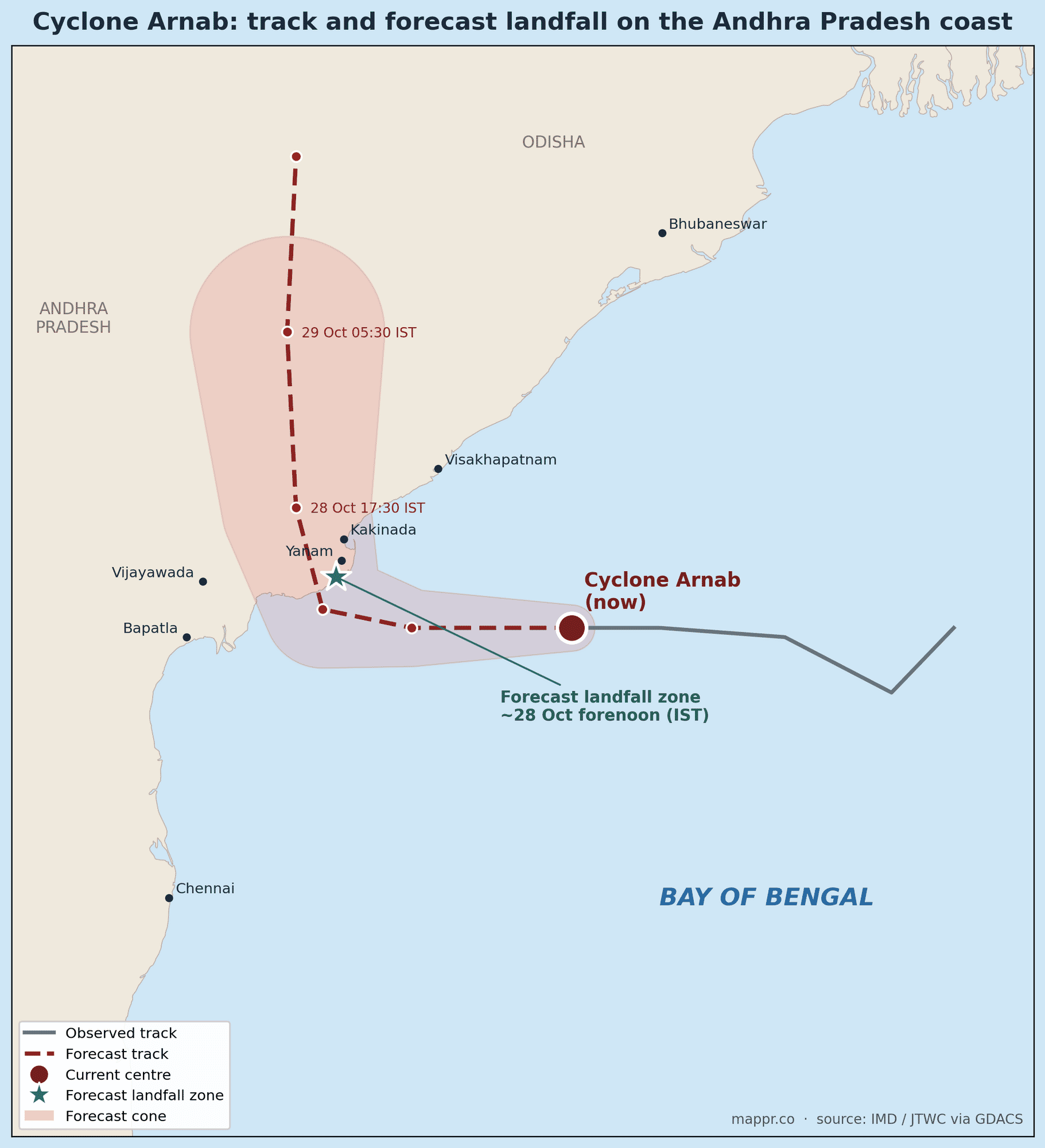
Cyclone Arnab’s track and forecast landfall
The storm is moving west-northwest across the Bay of Bengal and is forecast to curve toward the coast before turning north after landfall, carrying heavy rain inland across Andhra Pradesh and into Odisha.
Where and when it is expected to hit
The IMD’s forecast brings Cyclone Arnab ashore on the forenoon of 28 October (IST) along the Andhra Pradesh coast, in the stretch between Bapatla and Visakhapatnam and close to Yanam. Low-lying and coastal districts in this zone face the highest risk from wind, surge and flooding.
How strong Cyclone Arnab is
The IMD expects sustained winds of 115–125 km/h gusting to about 140 km/h at landfall, a storm surge of roughly 1 to 1.5 m above the normal tide, and extremely heavy rainfall that could flood coastal and low-lying areas. International agencies that use a different averaging method, such as the JTWC, put the peak intensity somewhat higher, which is normal for the same storm; the IMD figures are the official guidance for India.
Alerts, evacuations and closures
Authorities have issued red alerts for Andhra Pradesh and Odisha. Preparations include evacuating more than 89,000 people, closing schools, cancelling dozens of trains, deploying National Disaster Response Force (NDRF) teams, and restricting fishing and coastal activity. Fishermen have been advised not to venture into the Bay of Bengal.
What happens after landfall
Cyclones weaken quickly once they move over land and lose their warm-ocean fuel. Arnab is forecast to turn north after coming ashore, weakening as it goes, but it is likely to keep dropping heavy rain across interior Andhra Pradesh and into Odisha, where flooding rather than wind becomes the main hazard.
Forecasts and figures in this article are drawn from the following sources.