Key Takeaways
- Powerful quake hits Kyushu. A magnitude 6.8 earthquake (initially reported as 7.1 by Japanese authorities) struck near the coastal city of Uto in Kumamoto Prefecture at 4:27 p.m. local time on 28 July 2026. At just 10 km deep, the shaking was violent enough to be felt in South Korea.
- Mall collapse, then an explosion. Part of the second floor of an Aeon Mall in Kashima Town collapsed, and about an hour later a suspected gas-leak explosion tore through the complex. Some 3,000 customers were evacuated to the parking lot, but three people were killed in the blast and three store employees remain missing.
- 34 dead, search continuing. Prime Minister Sanae Takaichi confirmed 13 deaths by Wednesday morning and called the search for the missing “a race against time.” By Friday the prefectural government had raised the toll to 34 dead, with dozens injured, six of them seriously. The USGS issued its highest-level red alert.
- Tsunami advisory lifted. A tsunami advisory was issued immediately after the quake and lifted soon after, with no damaging waves recorded. Regulators found no abnormalities at the three nuclear power plants on Kyushu.
- Echoes of 2016. The quake struck the same region as the deadly 2016 Kumamoto earthquakes, and once again damaged the stone walls of Kumamoto Castle, still under repair a decade later. It is Japan's strongest earthquake since the 2024 Noto Peninsula disaster.
A powerful earthquake struck Japan’s southwestern island of Kyushu on the afternoon of 28 July 2026, collapsing buildings, splitting open the Kyushu Expressway and setting off fires across Kumamoto Prefecture. The magnitude 6.8 quake (first reported as 7.1) hit at 4:27 p.m. local time, centred near the coastal city of Uto, about 48 km (30 miles) southwest of Kumamoto City.
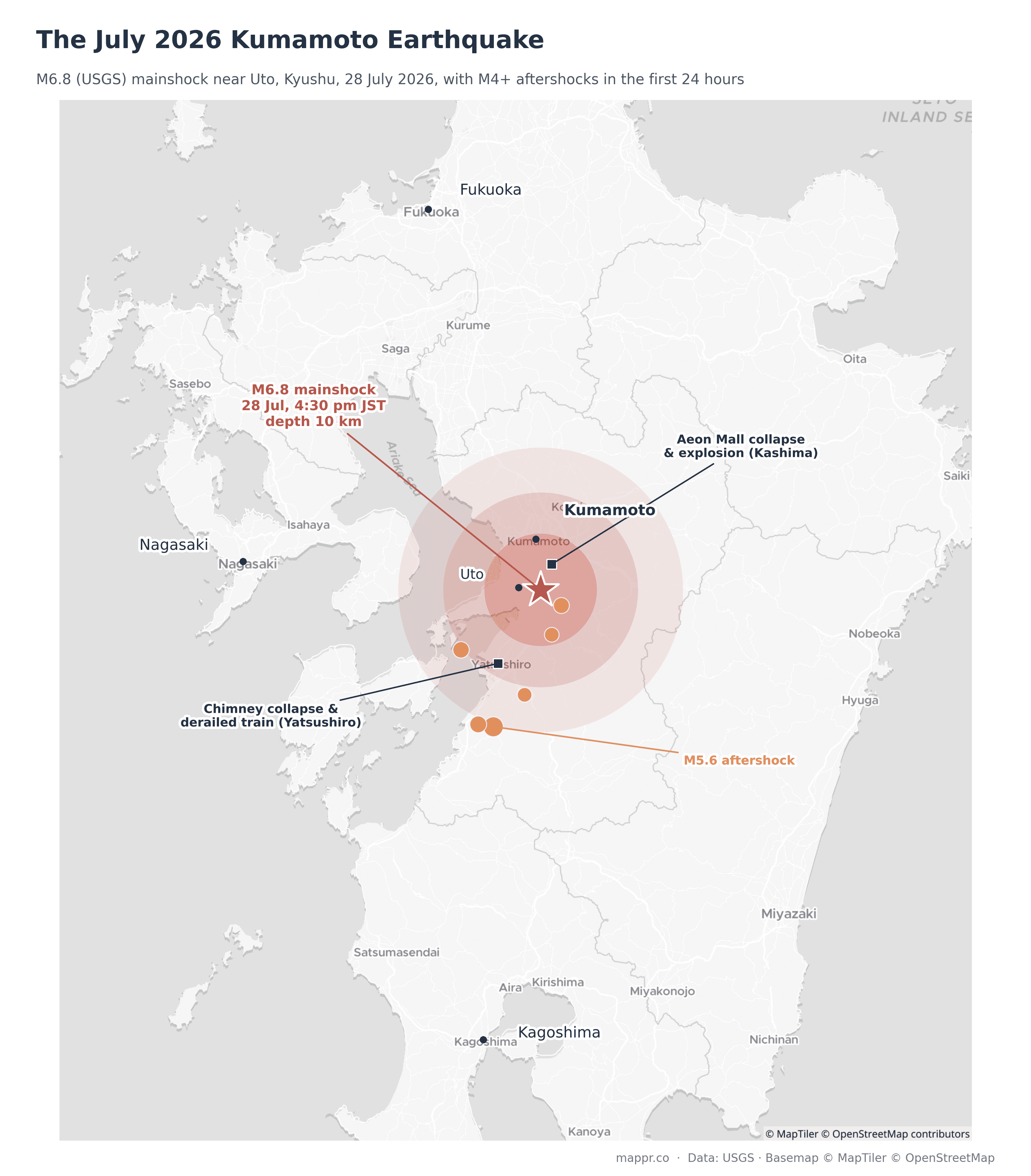
By Friday, the toll had climbed to 34 deaths, with search crews still working the two worst sites, a partially collapsed shopping mall and a paper factory. “There are people who are still waiting to be rescued, and it’s a race against time,” she said. The map below shows the epicenter, the first day of aftershocks, and the worst-hit sites.
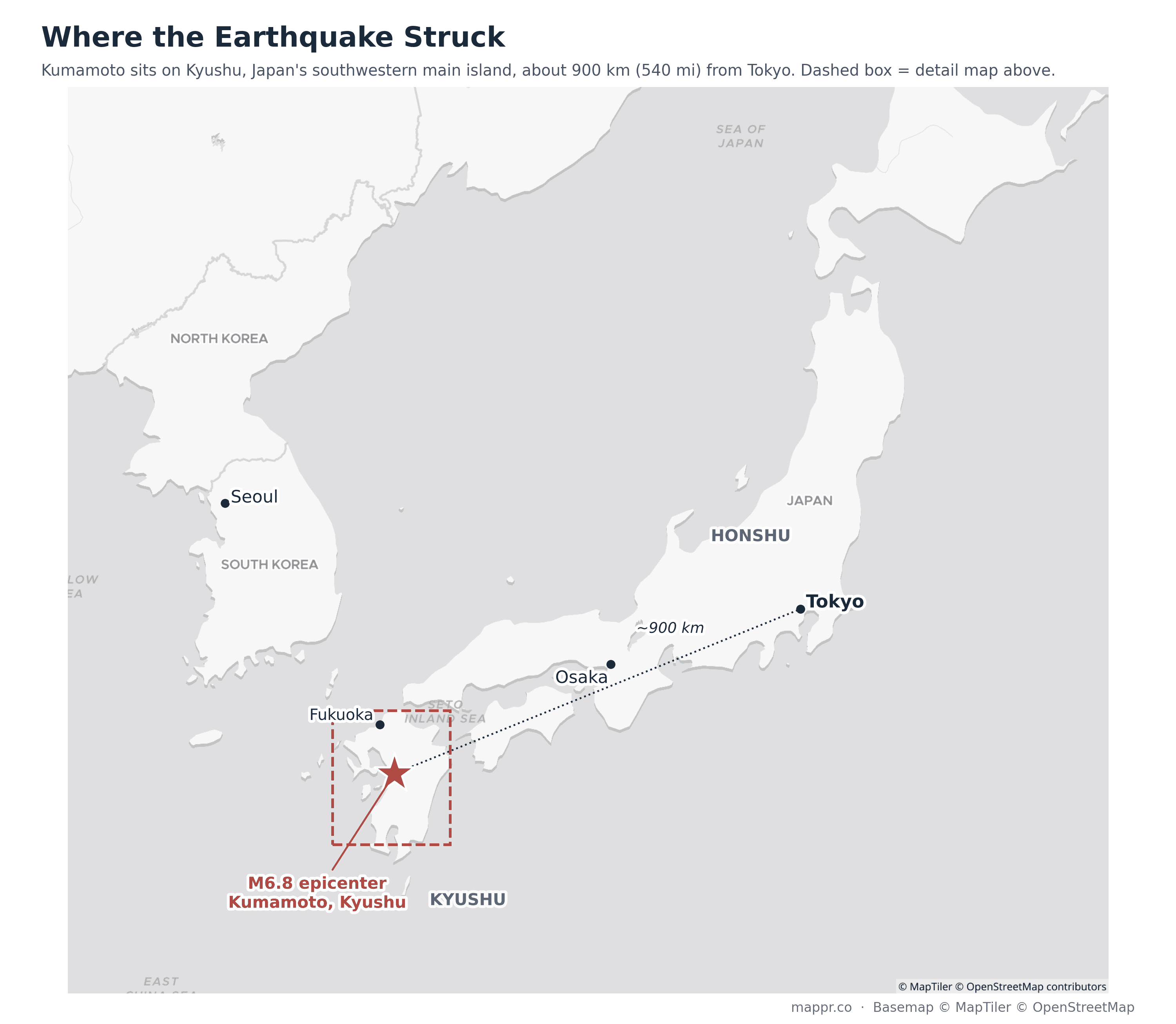
For readers less familiar with Japan’s geography: Kumamoto lies on Kyushu, the southwesternmost of the country’s four main islands, about 900 km (540 mi) from Tokyo and just across the Korea Strait from South Korea. The dashed box marks the area shown in the detail map above.
Casualties and latest updates
Latest developments
- July 31 (latest): The Kumamoto prefectural government raises the confirmed death toll to 34, up from 25 on Thursday, including deaths suspected to be disaster-related. Nearly half of the victims were killed in the two worst incidents, the Aeon Mall explosion and the Nippon Paper chimney collapse. Search operations continue at both sites in punishing heat, with temperatures around 34°C (93°F) prompting heatstroke warnings for rescuers and the thousands still in shelters.
- July 29 (evening): The Kumamoto prefectural government raises the toll to 18 dead and at least 62 injured, six seriously. At the Aeon Mall, president Akio Yoshida confirms three people were killed in the explosion and three store employees are still missing; the company says some 3,000 customers had been evacuated to the parking lot before the blast. In Yatsushiro, the chimney collapse at the Nippon Paper factory has killed five workers, with seven rescued and four still believed trapped. Nearly 34,900 homes are without power and about 15,000 without running water; more than 8,800 people are staying in over 400 shelters, where extra power sources are being added for air conditioning in the summer heat. Roughly 190 aftershocks were recorded in the first 24 hours. Bullet train services remain suspended; operations at Aso Kumamoto Airport resume, though some airlines cancel flights. Firefighters from Taiwan join the search effort.
- July 29 (morning): Prime Minister Sanae Takaichi confirms the death toll has risen to 13, with rescue work continuing through Wednesday morning for the missing. Japan’s Self-Defense Forces join the search at the badly damaged Aeon Mall, deliver water and transfer patients. At the Nippon Paper factory in Yatsushiro, seven people remain feared trapped under a collapsed chimney; two survivors and two bodies have been recovered so far. The JMA urges residents to stay cautious for two to three days as aftershocks continue.
- July 28 (overnight): A magnitude 4.1 aftershock rattles Kumamoto Prefecture just after midnight, per NHK, one of more than a dozen recorded since the mainshock, the largest a magnitude 5.6 south of the epicenter. The disaster management agency says about 300,000 people have been instructed to move to evacuation centers.
- July 28 (evening): A hospital in Yatsushiro takes in about 40 injured people and roughly 50 more are treated at a hospital in Kumamoto City. Fires burn in Kumamoto City, a residential building is filmed ablaze from the air, and thousands of homes lose power. The runway at Aso Kumamoto Airport is closed, a train derails and tips onto its side at Yatsushiro Station, and stone walls collapse at Kumamoto Castle.
- July 28 (afternoon): The quake strikes at 4:27 p.m. local time near Uto. The Japan Meteorological Agency initially reports magnitude 7.1 (later revised to 6.8 by the USGS) and issues a tsunami advisory, which is lifted shortly after with no damaging waves. At an Aeon Mall in Kashima Town, employees evacuate about 200 shoppers after part of the second floor collapses; roughly an hour later an explosion, believed to be from a gas leak, tears through the building. The Nuclear Regulation Authority reports no abnormalities at the region’s three nuclear plants.
What happened: a shallow quake under a populated coast
According to the USGS, the quake ruptured at a depth of only 10 km, directly beneath the shore of the Ariake Sea near Uto. Shallow quakes transmit far more of their energy to the surface than deep ones, which is why the shaking reached the highest bands of Japan’s intensity scale across central Kumamoto.
The shaking was strong enough to be felt in South Korea, roughly 300 km away. NHK footage showed sections of the Kyushu Expressway split apart near Yatsushiro, and many of Kyushu’s major manufacturers halted production lines as a precaution before resuming on Wednesday.
Within 24 hours the USGS had logged six aftershocks of magnitude 4.4 or greater, the largest a magnitude 5.6 near Tsunagi, south of the epicenter. You can follow the sequence in real time on our live earthquake map.
The mall collapse and explosion
The single worst incident unfolded at an Aeon shopping mall in Kashima Town, just southeast of Kumamoto City. When the quake struck, part of the mall’s second floor pancaked down. The mall was bustling at the time, and the operator says some 3,000 customers were evacuated to the parking lot.
About an hour later, a powerful explosion, believed by prefectural officials to have come from a gas leak, blew out walls and stripped the structure to its steel frame. Three people were confirmed killed in the blast, all of them working in the building, and three store employees remained missing as of Wednesday evening, with Self-Defense Force teams and firefighters still searching the wreckage.
In Yatsushiro, a chimney collapsed at a Nippon Paper Industries factory, burying workers under debris. The collapse killed five workers; seven were rescued from the debris and four more were still believed trapped as of Wednesday evening. A train derailed and fell onto its side at Yatsushiro Station, and the runway at Aso Kumamoto Airport was closed for inspections.
Japan’s strongest quake since the 2024 Noto disaster
The Uto quake is Japan’s most intense since the magnitude 7.6 Noto Peninsula earthquake of January 2024, which killed around 500 people in later tallies. The chart below places it among the country’s deadliest earthquakes of the past three decades.
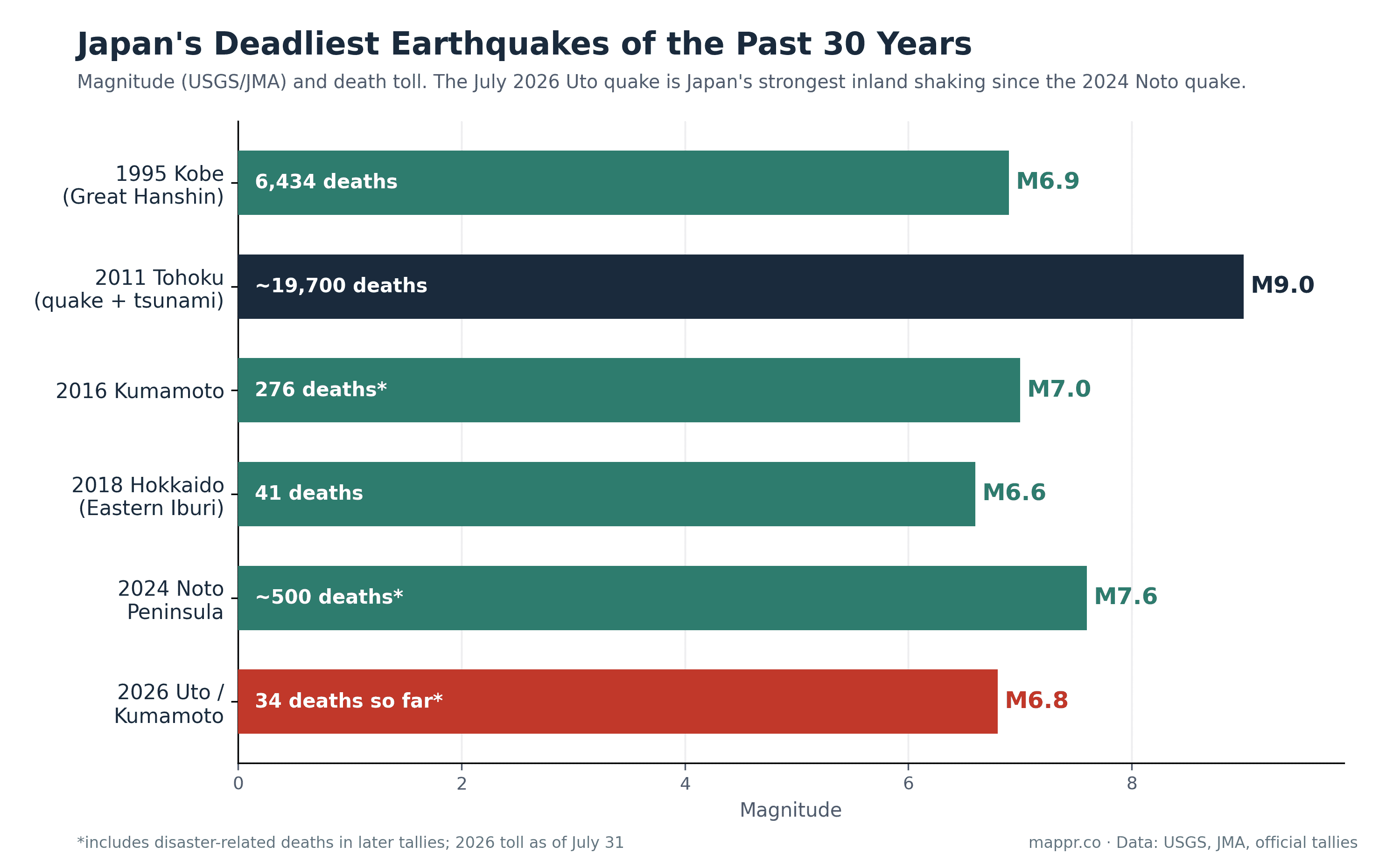
For Kumamoto, the disaster is painfully familiar. In April 2016, a pair of quakes (a magnitude 6.2 foreshock and a magnitude 7.0 mainshock) struck almost the same area, killing at least 50 people directly and more than 270 in total once disaster-related deaths were counted.
Kumamoto Castle, one of Japan’s most celebrated fortresses, was badly damaged in 2016 and has been under reconstruction ever since. This week’s quake toppled sections of its stone walls again, a full decade into the repair effort. “The shaking reminded me of the Kumamoto quake and I was frightened,” a town-hall official in nearby Mifune told the Associated Press.
Why Kyushu shakes
Kyushu sits above the collision zone where the Philippine Sea Plate dives beneath the Eurasian Plate, but Tuesday’s quake was not a deep subduction event. Like the 2016 disaster, it was a shallow crustal earthquake in the fault network that cuts across central Kumamoto, including the Futagawa and Hinagu fault zones.
These inland faults rupture far less often than the offshore trenches, but when they do, the shaking arrives with almost no warning and at close range to towns and cities. That is what makes shallow Kyushu quakes so destructive relative to their magnitude: the energy has only a few kilometres of rock to travel through before it reaches the surface.
What comes next
The Japan Meteorological Agency has urged residents to remain cautious for two to three days, the window in which large aftershocks are most likely, and to stay clear of buildings weakened by the mainshock. The 2016 sequence is a sobering precedent: there, the largest quake came 28 hours after what seismologists had assumed was the mainshock.
Attention will also turn to summer heat in the evacuation centers, where hundreds of thousands of residents were told to shelter. We’ll keep updating this post and the live earthquake map as confirmed figures emerge. Our earlier coverage of the April 2026 Sanriku coast earthquake covers Japan’s tsunami warning system in more depth.
Sources: