The United States of America is a country made up of 50 States and 1 Federal District. These states are then divided into 5 geographical regions: the Northeast, the Southeast, the Midwest, the Southwest, and the West, each with different climates, economies, and people.

USA State Names Abbreviations and Regions:
| Abbreviation | State Name | Region |
|---|---|---|
| AL | Alabama | Southeast |
| AK | Alaska | West |
| AZ | Arizona | Southwest |
| AR | Arkansas | Southeast |
| CA | California | West |
| CO | Colorado | West |
| CT | Connecticut | Northeast |
| DE | Delaware | Northeast |
| FL | Florida | Southeast |
| GA | Georgia | Southeast |
| HI | Hawaii | West |
| ID | Idaho | West |
| IL | Illinois | Midwest |
| IN | Indiana | Midwest |
| IA | Iowa | Midwest |
| KS | Kansas | Midwest |
| KY | Kentucky | Southeast |
| LA | Louisiana | Southeast |
| ME | Maine | Northeast |
| MD | Maryland | Northeast |
| MA | Massachusetts | Northeast |
| MI | Michigan | Midwest |
| MN | Minnesota | Midwest |
| MS | Mississippi | Southeast |
| MO | Missouri | Midwest |
| MT | Montana | West |
| NE | Nebraska | Midwest |
| NV | Nevada | West |
| NH | New Hampshire | Northeast |
| NJ | New Jersey | Northeast |
| NM | New Mexico | Southwest |
| NY | New York | Northeast |
| NC | North Carolina | Southeast |
| ND | North Dakota | Midwest |
| OH | Ohio | Midwest |
| OK | Oklahoma | Southwest |
| OR | Oregon | West |
| PA | Pennsylvania | Northeast |
| RI | Rhode Island | Northeast |
| SC | South Carolina | Southeast |
| SD | South Dakota | Midwest |
| TN | Tennessee | Southeast |
| TX | Texas | Southwest |
| UT | Utah | West |
| VT | Vermont | Northeast |
| VA | Virginia | Southeast |
| WA | Washington | West |
| WV | West Virginia | Southeast |
| WI | Wisconsin | Midwest |
| WY | Wyoming | West |
We define regions by looking at the areas’ climate, landscape, and location. The regions of the US are very vast, so much that sometimes it can be difficult to tell where one state ends and another begins. Each region may also have a unique culture and accent. Southerners have the most distinct regional accent in the country.
The Northeast is the most populated region in America, followed by the Southeast. Then comes the Midwest, located between the East and West coasts, and known for its agriculture.
The least populated regions are the Southwest and West. Let’s take a more in-depth look at the 5 regions of the United States.
Northeast 🍁

The Northeast region is also known as the ‘North East’ or simply as ‘The Northeast’. This regional division has some of the country’s most populated and heavily industrialized cities, including New York City, Philadelphia, and Boston. The Northeast is also one of the wealthiest parts of the United States in terms of per capita income and average household disposable income.
Forestry is here, especially in Maine and Pennsylvania – where they produce a large amount of paper. Fishing and shellfish also have importance in the economy of this region. Boston and New York City are big players in the region’s economy.
The biggest industries are pharmaceuticals, technology, and education, while the service industry grows rapidly. Tourism also plays a big part in this region’s income as many people flock to New York all year.
Name brands like Dunkin’ Donuts, Baskin Robbins, and Krispy Kreme started in this region. The Northeast also has some of the top higher education institutions in the world. Harvard University, Yale University, and the Massachusetts Institute of Technology host top students.
The dense population, high production capability, and first-class infrastructure of this region mean that the Northeast is home to some of the largest seaports in the world.
It has access to waterways via the Hudson River, which runs through New York City and is connected to states in the Northeast by major rivers, including the Potomac River.
The states of this region include:
- Massachusetts
- Rhode Island
- Connecticut
- Vermont
- New Hampshire
- Maine
- Pennsylvania
- New Jersey
- New York
Key Cities: Boston, New York City, Philadelphia, Baltimore;
Weather/Climate
This part of the country has all four seasons. Summers are hot and humid, while winters are cold with lots of snowfall. Leaves change color in the fall. Hurricanes sometimes hit the coasts in the late summer.
Southeast 🌴

The Mason-Dixon line, which was agreed upon in the 1760s, divided the North from the South. States like Maryland and Delaware that are close to this line have a more northern climate, with colder winters and less extreme heat in the summer. Maryland and Delaware also make up a subregion known as the Mid-Atlantic area.
Related: US Southeast Map
For a long time, the primary industry of this area was agriculture. Its fertile soil, flat ground, and long growing season are all factors that contribute to its great growth potential. Most of the year, farmers here can produce crops. Citrus, peaches, rice, cotton, tobacco, sugar cane, and peanuts are just a few examples of the plants that come from this region.
It is also a popular tourist destination due to its climate, beaches, and history. Some of the most popular beaches include Siesta Key, Miami Beach, Myrtle Beach, and Hampton Beach. Let’s not forget about the Outer Banks of North Carolina – the only barrier islands off the east coast of the US.
This region has lower costs of living than the Northeast or the West Coast but is more expensive than other parts of the South. The Southeast is also home to many national parks, such as the Great Smoky Mountains National Park and Everglades National Park.
The states of this region include:
- Washington DC ( federal district)
- Georgia
- North Carolina
- South Carolina
- Virginia
- West Virginia
- Kentucky
- Tennessee
- Mississippi
- Alabama
- Delaware
- Maryland
- Florida
- Louisiana
- Arkansas
Key Cities: Atlanta, Tampa, Miami, New Orleans, Raleigh, Charlotte
Weather/Climate
The climate of the Southeast is humid subtropical. The area has hot, humid summers and mild to cool winters. It receives abundant rainfall all year long. Hurricanes are also common in the summer and fall.
Midwest 🌽

The Midwest is often described as “America’s Heartland.” Some of the largest cities in the country, such as Chicago and Minneapolis, are here.
This region has agriculture and mining. Aside from the Great Lakes, which is where most of the biodiversity is located within this region, it is also home to important ecosystems such as the Western Prairie and Eastern Woodlands.
The Midwest sits midway between the Rocky Mountains and the Appalachians. It is also north of the Ohio River and the 37th parallel. This region has also produced groundbreaking musical acts such as B.B. King, Rock and Roll Hall of Famer James Brown, The Jacksons, Prince, and Motown Music Studios.
The states of this region include:
- Minnesota
- Wisconsin
- Illinois
- Ohio
- Indiana
- Michigan
- Missouri
- Iowa
- Kansas
- Nebraska
- North Dakota
- South Dakota
Weather/Climate
The summers are hot and humid in this region. Winters are usually cold, with lots of snowfall. The region is known for its tornado outbreaks, too.
Key Cities: Minneapolis, Chicago, Cincinnati, Columbus, Cleveland, Detroit, St. Louis
Southwest 🌵

The Southwest region is home to some beautiful landscapes, from arid deserts to canyons and plateaus. This region is also known for its ghost towns, which were once homes to hearty pioneers who settled the area.
National parks include the Grand Canyon National Park, Chaco Culture National Historical Park, and Petrified Forest National Park, to name a few.
Albuquerque, Phoenix, and Tucson are all popular tourist destinations. The red sand of Sedona in Arizona, which was formed by the erosion of red rocks, is another famous tourist spot.
Texas, a state in this region, is known for its famous music scene. Austin City Limits or South by Southwest are very popular music festivals.
The states of this region include:
- New Mexico
- Arizona
- Oklahoma
- Texas
Weather/Climate
Most of this region is an arid desert, so it is usually hot and dry. However, in higher altitudes, you can see snow in the mountains.
Key Cities: Phoenix, Oklahoma City, Dallas, Houston, Austin, Salt Lake City
The West 🏞️

In the Western states, most of the water is used for irrigation. The West has plenty of mineral reserves, including coal and uranium ore. This region also produces oil and gas. The Alaska pipeline carries oil from the North Slope of Alaska all the way to market in Valdez.
This region is also home to many national parks such as Yellowstone National Park, Glacier National Park, the Grand Canyon, Crater Lake National Park, and Bryce Canyon National Park.
Silicon Valley is located in California and is one of the most bustling tech hubs in the world. This region also has a major influence on culture, especially Hollywood and other forms of media such as rock and roll and country music.
States such as Alaska and Hawaii are also politically part of the West but are geographically isolated. Those two states are part of the non-continental US.
The states of this region include:
- California
- Colorado
- Nevada
- Hawaii
- Alaska
- Oregon
- Utah
- Idaho
- Montana
- Wyoming
- Washington
Weather/Climate
Most of the region is arid, except for the Northwest, which has heavy rain and lush vegetation. The summers are typically hot, but winters are mild to cold, depending on the state. Colorado and Wyoming have cold and snowy weather. Southern California has hot weather all year. Mudslides and earthquakes are also common in California.
Key Cities: Los Angeles, San Francisco, Seattle, Honolulu, San Diego, Las Vegas, Denver, Billings, Phoenix, Salt Lake City
Census Map
As we look at the 5 regions of the United States, one can see how they differ. However, when we look at the Census map, we don’t see 5 regions of the United States – we only see 4 regions:

The standout difference on the Census Map is in the southern region. Instead of dividing the South into the Southeast and the Southwest, it is only one southern region.
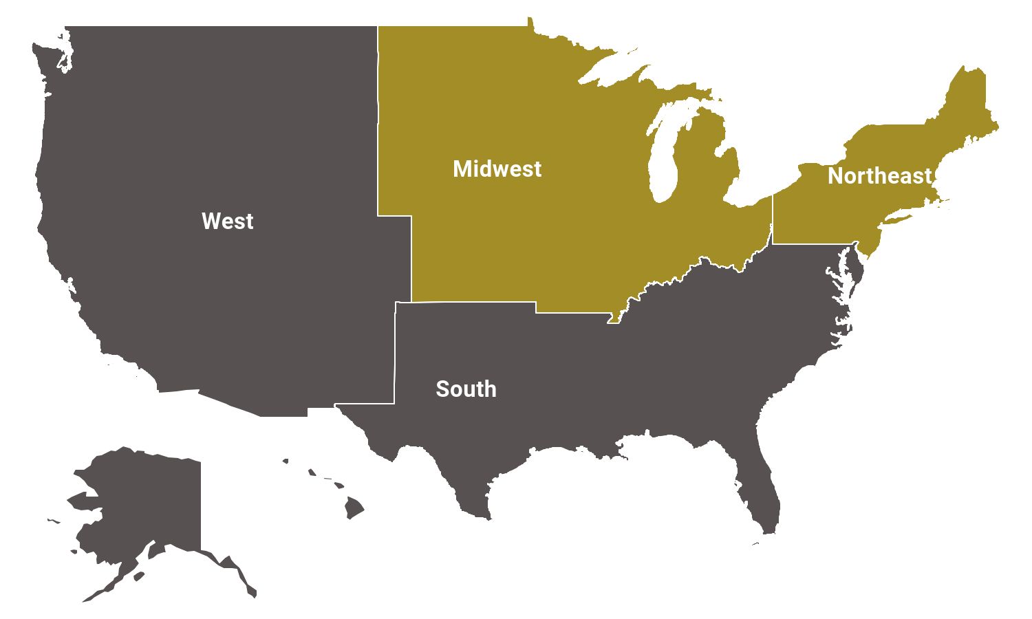
The census map notes the regional subdivisions such as The Mid-Atlantic and New England regions that make up the Northeast. The Midwest has the East North and West North Central divisions.
The South contains the South Atlantic, East South Central, and West South Central Divisions. Mountain and Pacific divisions make you the Western states. The West Coast Pacific States include California, Oregon, and Washington.
In conclusion, the United States is a massive country with regions and subdivisions. Regarding climate, economy, and geographical changes, you can expect something different based on what part you’re in.
🗺️ Interactive US Map Tools
Discover all our free interactive maps and tools.


- Autumn in a Small Vermont Town — © JeniFoto/Shutterstock
- Tropical Beach Path at Sunrise in Florida — © ventdusud/Shutterstock
- Aerial View of a Midwest Cornfield — © DesignFlip/Shutterstock
- Saguaro Cactus in Arizona Desert Landscape — © Jonathan Manjeot/Shutterstock