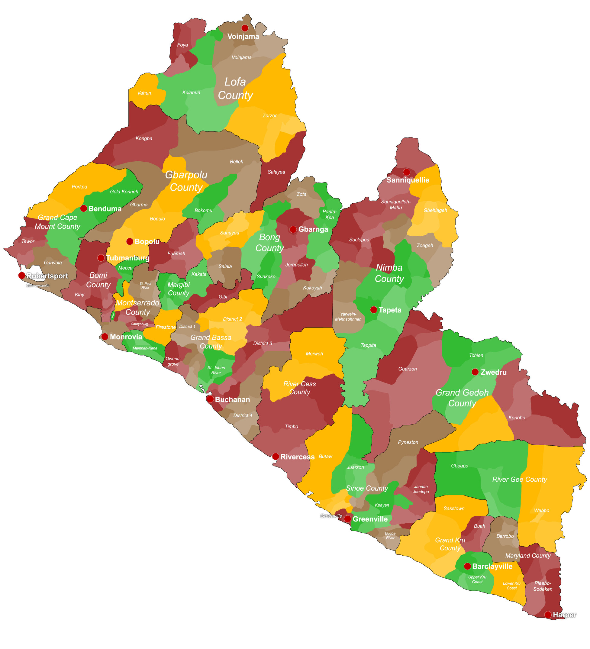
The Republic of Liberia is divided into fifteen counties. Each is run by a superintendent appointed by the President. The counties are Liberia’s top administrative divisions. The final division was completed in 2001.
Fifteen Counties of Liberia
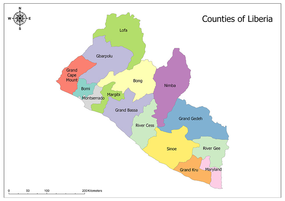
Liberia is divided into fifteen first-level administrative divisions. These administrative divisions are Bomi, Bong, Gbarpolu, Grand Bassa, Grand Gedeh, Grand Kru, Lofa, Margibi, Maryland, Montserrado, Nimba, Rivercess, River Gee and Sinoe
Bomi
Bomi is one of the fifteen counties of Liberia. The county is located in the northwestern part of the country. Bomi county has a surface area of 1,942 square kilometers and a population of 82,036 according to 2008 population data. County was founded in 1984, and its capital is Tubmanburg. Bomi is divided into four districts.
Bong
Bong is one of the fifteen counties of Liberia. The county is located in the northern and central part of the country. Bong County has a surface area of 8,772 square kilometers and a population of 328,919 according to 2008 data. County was founded in 1964, and its capital is Gbarnga. Bong is divided into twelve districts.
Gbarpolu
Gbarpolu is one of the fifteen counties of Liberia. The county is located in the northwestern part of the country. Gbarpolu county has a surface area of 9,689 square kilometers and a population of 83,758 according to 2008 data. County was established in 2001, and its capital is Bopolu. Gbarpolu is divided into six districts. Gbarpolu is the newest county in Liberia.
Grand Bassa
Grand Bassa is one of Liberia’s fifteen counties. The county is located in the central part of the country. Grand Bassa County has a surface area of 7,936 square kilometers and a population of 224,839 according to 2008 data. County was founded in 1839, and its capital is Buchanan. Grand Bassa is divided into eight districts. Montserrado, together with Grand Bassa, is one of the Libera’s.
Grand Cape Mount
The Grand Cape is one of the fifteen counties of Mount Liberia. The county is located in the western part of the country. The area of Grand Cape Mount County has a surface area of 5,162 square kilometers and a population of 129,055 according to 2008 data. County was founded in 1844, and its capital is Robertsport. The Grand Cape Mount is divided into five districts.
Grand Gedeh
Grand Gedeh is one of the fifteen counties of Liberia. The county is located in the eastern part of the country. Grand Gedeh County has a surface area of 10,484 square kilometers and a population of 126,146 according to 2008 data. County was founded in 1964, and its capital is Zwedru. Grand Gedeh is divided into three districts.
Grand Kru
Grand Kru is one of the fifteen counties of Liberia. The county is located in the southeastern part of the country. The area of Grand Kru county has a surface area of 3,895 square kilometers and a population of 57,106 according to 2008 data. County was founded in 1984, and its capital is Barclayville. Grand Kru is divided into eighteen districts and is also the most district-separated County of Liberia.
Lofa
Lofa is one of Liberia’s fifteen counties. The county is located in the northernmost part of the country. Lofa county has a surface area of 9,982 square kilometers and a population of 270,114 according to 2008 data. County was founded in 1964, and its capital is Voinjama. Lofa is divided into six districts.
Margibi
Margibi is one of Liberia’s fifteen counties. The county is located in the central and western part of the country. Margibi County has a surface area of 2,616 square kilometers and a population of 199,689 according to 2008 data. County was founded in 1985, and its capital is Kakata. Margibi is divided into four districts.
Maryland
Maryland is one of the fifteen counties of Liberia. The county is located in the southernmost part of the country. Maryland county has an area of 2,297 square kilometers and a population of 136,404 according to 2008 data. County was founded in 1857, and the capital is Harpe. Maryland is divided into two districts.
Montserrado
Montserrado is one of the fifteen counties of Liberia. The county is located in the western part of the country. The area of Montserrado county has a population of 1,144,806 according to 2008 population data and a surface area of 1,909 square kilometers. It is the county with a minimum surface area and is also the most populated. County was founded in 1839, and the capital is Bensonville. Montserrado is divided into four districts. Montserrado, together with Grand Bassa, is one of Libera’s oldest counties.
Nimba
Nimba is one of the fifteen counties of Liberia. The county is located in the central and northern part of the country. Nimba county has a surface area of 46,500 square kilometers and a population of 468,088 according to 2008 data. The county has the highest surface area. County was founded in 1964, and its capital is Sanniquellie. Nimba is divided into six districts.
Rivercess
Rivercess is one of the fifteen counties of Liberia. The county is located in the central and southern part of the country. Rivercess county has a surface area of 5,594 square kilometers, and a population of 65,862 according to 2008 data. County was founded in 1985, and its capital is River Cess. The Rivercess is divided into seven parts districts.
River Gee
River Gee is one of the fifteen counties of Liberia. The county is located in the southeastern part of the country. River Gee county has an area of 5,113 square kilometers and a population of 67,318 according to 2008 data. County was established in 2000, and its capital is Fish Town. River Gee is divided into six districts.
Sinoe
Sinoe is one of the fifteen counties of Liberia. The county is located in the southern and eastern part of the country. Sinoe county has a surface area of 10,137 square kilometers and a population of 104,932 according to 2008 data. County was founded in 1843, and its capital is Greenville. Sinoe is divided into seventeen districts.
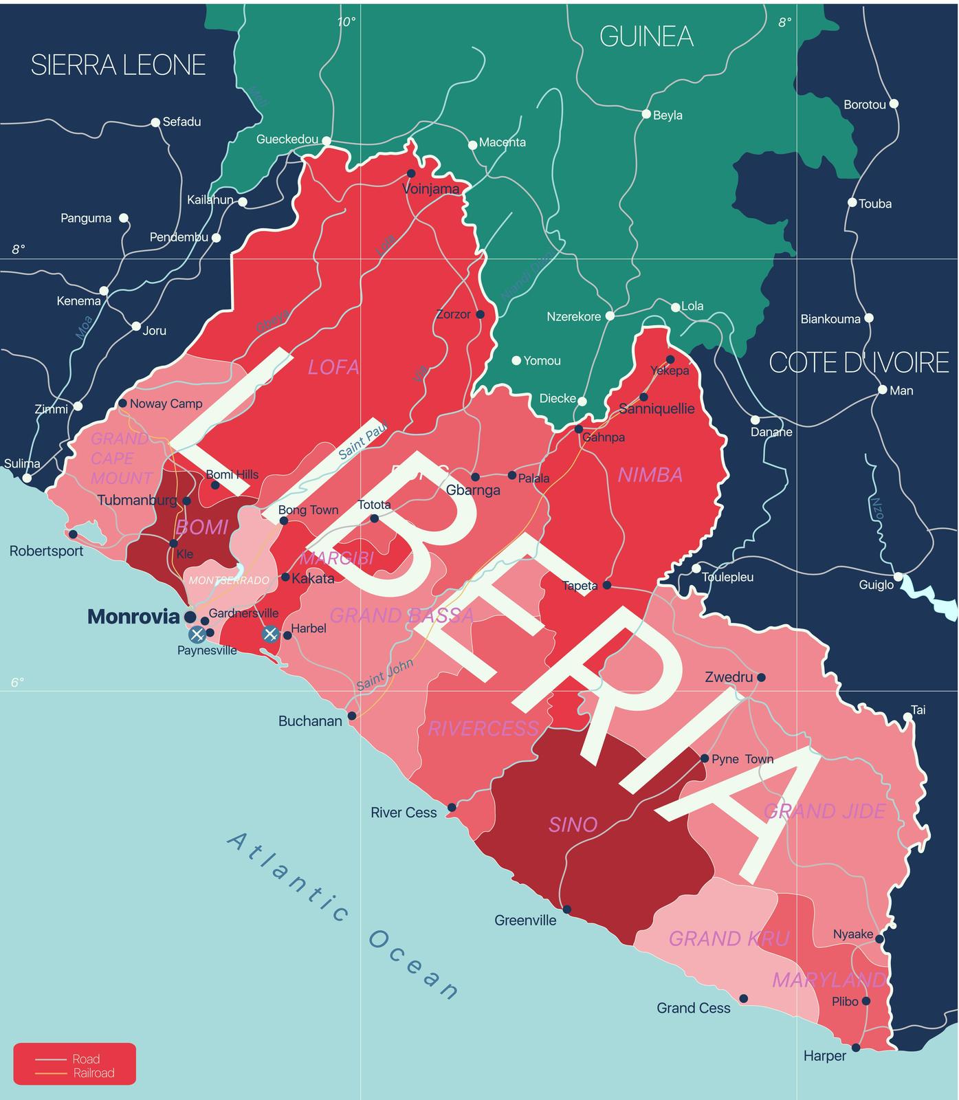
Liberia Regions Map
Liberia Counties Map