Kenya is divided into 47 counties. Kenya consisted of eight provinces until the new administrative structure in 2010 was adopted.
47 counties were established as a result of the new administrative structure in 2010, which came into force in March 2013.
These 47 counties have eliminated the administrative structure which consisted of eight provinces.
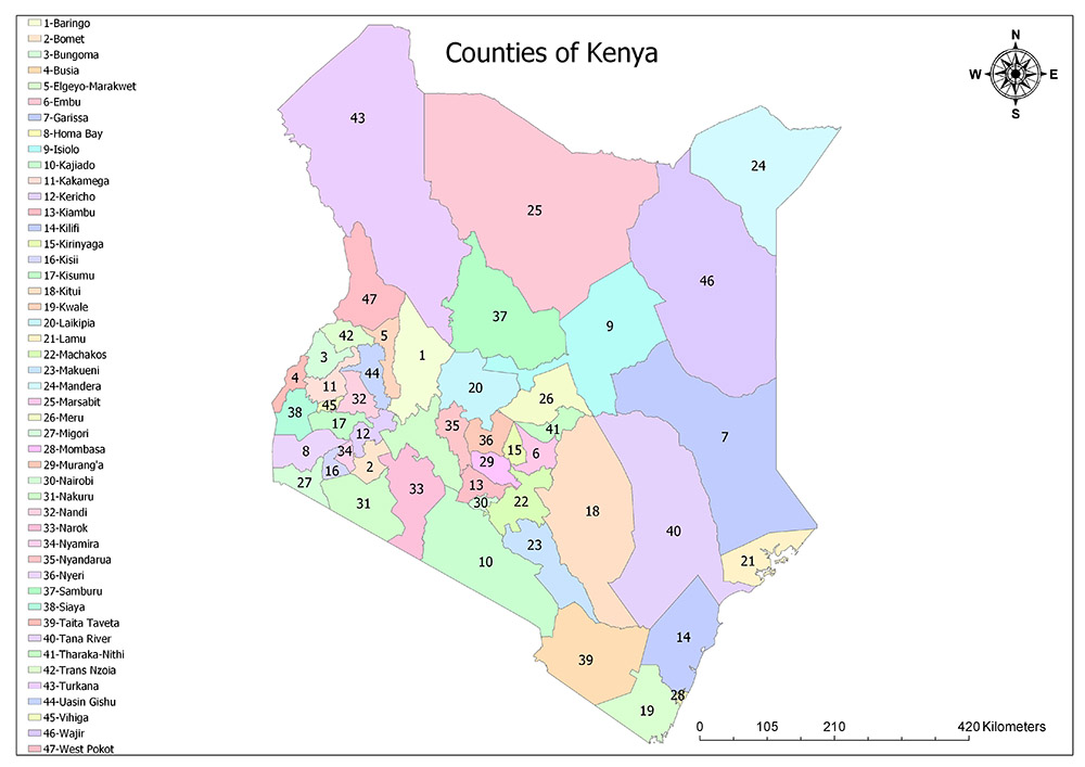
Forty-Seven Counties of Kenya
Kenya has been divided into 47 counties since 2010.
These counties are:
- Mombasa
- Kwale
- Kilifi
- Tana River
- Lamu
- Taita Mak Taveta
- Garissa
- Wajir
- Mandera
- Marsabit
- Isiolo
- Meru
- Tharaka-Nithi
- Embu
- Kitui
- Machakos
- Makueni
- Nyandarua
- Nyeri
- Kirinyaga
- Murang’a
- Kiambu The
- Turkana
- West Pokot
- Samburu
- Trans-Nzoia
- Uasin Gishu
- Elgeyo-Marakwet
- Nandi
- Baringo
- Laikipia
- Nakuru
- Narok
- Kajiado
- Kericho
- Bomet
- Kakamega
- Vihiga
- Bungoma
- Busia
- Siaya
- Kisumu
- Homa Bay
- Migori
- Kisii
- Nyamira
- Nairobi
Mombasa
Mombasa is one of Kenya’s 47 counties. The county is located in the southeast of the country. Mombasa was initially one of the oldest areas of Kenya but was re-established as a county in 2013 on the same borders. It is the smallest district in Kenya and covers an area of 294.7 square kilometers. According to the data of Mombasa census in 2009, the population is 939,370 and the population density is 3,200 / sq. Km.
Kwale
Kwale is one of Kenya’s 47 counties. The county is located in the southernmost part of the country. Although Ukunda is the largest city in the county, its capital is Kwale. The area of Kwale county is 8,270 square kilometers. According to the 2009 data of County, the population is 649,931 and the population density is 79 / square km.
Kilifi
Kilifi is one of Kenya’s 47 counties. County is located in the southeast of the country. It was founded in 2010 as a result of the merger of Kilifi Region and Malindi Region. Its capital is Kilifi and its largest city is Malindi. Kilifi County has an area of 12,255 square kilometers. According to 2009 data of County, the population is 1,109,735 and the population density is 91 / square km.
Tana River
Tana River is one of the 47 counties of Kenya. County is located in the southern and eastern part of the country. The region is named after Tana River. The largest city and capital of County is Hola. The city is also known as Galole. The area of Tana River county is 35,375 square kilometers. According to 2009 data, County has a population of 240,075 and population density is 6.8 / square km.
Lamu
Lamu is one of Kenya’s 47 counties. County is located in the southern and eastern part of the country. The district consists of 65 islands and mainland which constitute the Lamu Archipelago. Lamu County’s capital is the Lamis city with the same name. County has an area of 6,273 square kilometers. According to 2009 data, County’s population is 101,539 and the population density is 16 / sq. Km.
Taita–Taveta
Taita-Taveta is one of Kenya’s 47 counties. County is located in the southern part of the country. It is situated about 150 km northwest of Mombasa and 300 km southeast of Nairobi. The capital is nominally in the town of Mwatate, but the district government offices are located in Wundanyi. County has an area of 17,083 square kilometers. According to 2009 data, County has a population of 284,657 and a population density of 17 / sq. Km.
Garissa
Garissa is one of Kenya’s 47 counties. County is located in the eastern part of the country. The capital and largest urban area is the Garissa city with the same name. County has an area of 45,720 square kilometers. According to 2009 data, County has a population of 623,060 and a population density of 14 / square km.
Wajir
Wajir is one of Kenya’s 47 counties. County is located in the northeast part of the country. Its capital and largest urban area are the Wajir city with the same name. County has an area of 55,840 square kilometers. According to 2009 data, County’s population is 661,941 and the population density is 12 / sq. Km.
Mandera
Mandera is one of Kenya’s 47 counties. County is located in the northeastern part of the country. The capital and the largest urban area is Mandera, the same name as the region. County has an area of 25,797 square kilometers. According to 2009 data, County has a population of 1,025,756 and a population density of 40 / square kilometer.
Marsabit
Marsabit is one of Kenya’s 47 counties. County is located in the northern part of the country. Although Moyale is the largest city in the county, its capital is Marsabit. County has an area of 66,923 square kilometers. According to 2009 data, County has a population of 291,166 and a population density of 4.4 / sq. Km.
Isiolo
Isiolo is one of Kenya’s 47 counties. County is located in the central and eastern part of the country. Its capital and largest urban area are the Isiolo city with the same name. County has an area of 25,336 square kilometers. According to 2009 data, County has a population of 143,294 and a population density of 5.7 / square km.
Meru
Meru is one of Kenya’s 47 counties. County is located in the central part of the country. Its capital and largest urban area are the city of Meru with the same name. County has an area of 6,936 square kilometers. According to 2009 data of County, the population is 1,356,301 and the population density is 195.6 / km2.
Tharaka-Nithi
Tharaka-Nithi is one of Kenya’s 47 counties. County is located in the central part of the country. County is the capital city of Kathwana. County has an area of 2,609 square kilometers. According to 2009 data, County has a population of 365,330 and a population density of 140 / sq. Km.
Embu
Embu is one of Kenya’s 47 counties. County is located in the central part of the country. Its capital and largest urban area are the Embu city with the same name. County has a surface area of 2,818 square kilometers. According to 2009 data of County, the population is 516,212 and the population density is 183.2 / square kilometer.
Kitui
Kitui is one of Kenya’s 47 counties. County is located in the central and southern part of the country. The capital and largest urban area is the Kitui city with the same name. County has an area of 24,385 square kilometers. According to 2009 data, County has a population of 1,012,709 and a population density of 41.5 / sq. Km.
Machakos
Machakos is one of Kenya’s 47 counties. County is located in the central and southern part of the country. Its capital and largest urban area is Machakos, which is the same name as the region. County has an area of 5,952 square kilometers. According to 2009 data of County, the population is 1,098,584 and the population density is 184.6 / square km.
Makueni
Makueni is one of Kenya’s 47 counties. County is located in the southern part of the country. The capital and largest urban area is the city of Wote. County has an area of 8,008 square kilometers. According to 2009 data of the county, the population is 884,527 and the population density is 110 / sq. Km.
Nyandarua
Nyandarua is one of Kenya’s 47 counties. County is located in the central and western part of the country. The capital and largest urban area is the city of Ol Kalou. County has an area of 3,107 square kilometers. According to 2009 data of the county, the population is 596,268 and the population density is 192 / sq. Km.
Nyeri
Nyeri is one of Kenya’s 47 counties. County is located in the central part of the country. Its capital and largest urban area is Nyeri, the city of the same name. County has an area of 2,361 square kilometers. According to 2009 data of County, the population is 693,558 and the population density is 294 / square kilometers.
Kirinyaga
Kirinyaga is one of Kenya’s 47 counties. County is located in the central part of the country. Although the city of Wanguru is the largest city in the county, its capital is Kutus. County has an area of 1,205 square kilometers. According to 2009 data, County has a population of 528,054 and a population density of 438 / square kilometer.
Muranga
Muranga is one of the 47 counties of Kenya. County is located in the central and southern part of the country. Its capital and largest urban area are the city of Muranga, which is the same name as the region. County has an area of 2,325 square kilometers. According to 2009 data, County’s population is 942,581 and its population density is 405 / square kilometer.
Kiambu
Kiambu is one of Kenya’s 47 counties. County is located in the central and southern part of the country. The city of Thika is the largest city in the county, but its capital city is Kiambu. County has an area of 2,449 square kilometers. According to 2009 data of County, the population is 1,623,282 and the population density is 660 / square km.
Turkana
Turkana is one of Kenya’s 47 counties. County is located in the northwestern part of the country and is the second largest county in the country. Lodwar is the capital and largest urban area. County has a surface area of 68,680 square kilometers. According to 2009 data, County’s population is 855,399 and the population density is 12.5 / sq. Km.
West Pokot
West Pokot is one of Kenya’s 47 counties. County is located in the western part of the country. The capital and largest urban area is Kapenguria. County has an area of 8,418 square kilometers. According to 2009 data of County, the population is 512,690 and the population density is 61 / square km.
Samburu
Samburu is one of Kenya’s 47 counties. County is located in the central and northern part of the country. The capital and largest urban area is the city of Maralal. County has an area of 20,182 square kilometers. According to 2009 data, County has a population of 223,947 and a population density of 11 / sq. Km.
Trans-Nzoia
Trans-Nzoia is one of Kenya’s 47 counties. County is located in the western part of the country. The capital and largest urban area is Kitale. County has a surface area of 2,469 square kilometers. According to 2009 data of the county, the population is 818,757 and the population density is 332 / square km.
Uasin Gishu
Uasin Gishu is one of Kenya’s 47 counties. County is located in the western part of the country. The capital and largest urban area is the city of Eldoret. County has a surface area of 2,955 square kilometers. According to 2009 data of County, the population is 894,179 and the population density is 303 / km2.
Elgeyo-Marakwet
Elgeyo-Marakwet is one of Kenya’s 47 counties. County is located in the western part of the country. Its capital and largest urban area is Iten city. County has an area of 3,049 square kilometers. According to 2009 data, County has a population of 369,998 and a population density of 121 / sq. Km.
Nandi
Nandi is one of Kenya’s 47 counties. County is located in the western part of the country. Its capital and largest urban area are the city of Capsabet. County has an area of 2,884 square kilometers. According to the 2009 data of County, the population is 752,965 and the population density is 261 / square km.
Baringo
Baringo is one of Kenya’s 47 counties. County is located in the central and western part of the country. The capital and largest urban area is the city of Kabarnet. County has an area of 11,075 square kilometers. According to 2009 data of the county, the population is 555,561 and the population density is 50 / square km.
Laikipia
Laikipia is one of Kenya’s 47 counties. County is located in the central and western part of the country. The capital and largest urban area is the city of Rumuruti. County has an area of 8,696 square kilometers. According to 2009 data, County’s population is 399,227 and the population density is 46 / sq. Km.
Nakuru
Nakuru is one of Kenya’s 47 counties. County is located in the central and western part of the country. Its capital and largest urban area is Nakuru, the same name as the region. County has a surface area of 7,509 square kilometers. According to 2009 data of County, the population is 1,603,325 and the population density is 214 / square kilometer.
Narok
Narok is one of the 47 counties of Kenya. County is located in the southwestern part of the country. Its capital and largest urban area is Narok, the same name as the region. County has an area of 17,921 square kilometers. According to 2009 data, County has a population of 850,920 and a population density of 47.5 / sq. Km.
Kajiado
Kajiado is one of Kenya’s 47 counties. County is located in the southwestern part of the country. Ngong city is the largest city in the county, but the capital city is Kajiado. County has an area of 21,292 square kilometers. According to 2009 data of County, the population is 687,312 and the population density is 32.2 / sq. Km.
Kericho
Kericho is one of Kenya’s 47 counties. County is located in the western part of the country. Its capital and largest urban area is Kericho, which is the same name as the region. County has an area of 2,454 square kilometers. According to 2009 data of County, the population is 752,396 and the population density is 307 / square km.
Bomet
Bomet is one of Kenya’s 47 counties. County is located in the western part of the country. Its capital and largest urban area are the Bomet city with the same name. County has an area of 1,630 square kilometers. According to 2009 data, County’s population is 724,186 and the population density is 440 / sq. Km.
Kakamega
Kakamega is one of Kenya’s 47 counties. County is located in the western part of the country. Its capital and largest urban area is the city of Kakamega, the same name as the region. County has an area of 3,033 square kilometers. According to 2009 data of County, the population is 1,660,651 and the population density is 548 / square km.
Vihiga
Vihiga is one of Kenya’s 47 counties. County is located in the western part of the country. The capital and largest urban area is the city of Mbale. County has an area of 531 square kilometers. According to 2009 data of the county, the population is 554,622 and the population density is 1,044 / square km.
Bungoma
Bungoma is one of Kenya’s 47 counties. County is located in the western part of the country. Its capital and largest urban area are the Bungoma city, which is the same name as the region. County has a surface area of 2,206 square kilometers. According to the data of County in 2009, the population is 1,375,063 and the population density is 623 / square km.
Busia
Busia is one of Kenya’s 47 counties. County is located in the western part of the country. Its capital and largest urban area is the Busia city, which is named after the region. County has an area of 1,628 square kilometers. According to 2009 data of the county, the population is 743,946 and the population density is 457 / square kilometer.
Siaya
Siaya is one of Kenya’s 47 counties. County is located in the western part of the country. Its capital and largest urban area are the Siaya city with the same name. County has an area of 2,496 square kilometers. According to 2009 data, County has a population of 842,304 and population density is 337 / square km.
Kisumu
Kisumu is one of Kenya’s 47 counties. County is located in the western part of the country. Its capital and largest urban area are the Kisumu city with the same name. County has an area of 2,085 square kilometers. According to 2009 data of County, the population is 968,879 and the population density is 460 / sq. Km.
Homa Bay
Homa Bay is one of Kenya’s 47 counties. County is located in the western part of the country. Its capital and largest urban area is Homa Bay, which is the same name as the region. County has an area of 3,154 square kilometers. According to 2009 data, County has a population of 963,794 and a population density of 306 / sq. Km.
Migori
Migori is one of Kenya’s 47 counties. County is located in the western and southern part of the country. Its capital and largest urban area is Migori, which is the same name as the region. County has an area of 2,586 square kilometers. According to 2009 data, County has a population of 917,170 and a population density of 355 / square kilometer.
Kisii
Kisii is one of Kenya’s 47 counties. County is located in the western and southern part of the country. Kisii is the capital and the largest urban area with the same name as the region. County has an area of 1,317 square kilometers. According to 2009 data of County, the population is 1,152,282 and the population density is 875 / square kilometer.
Nyamira
Nyamira is one of Kenya’s 47 counties. County is located in the western part of the country. Its capital and largest urban area is Nyamira, the same name as the region. County has an area of 912 square kilometers. According to 2009 data of the county, the population is 598,252 and the population density is 656 / square kilometer.
Nairobi
Nairobi is one of Kenya’s 47 counties. County is located in the central and southern part of the country. Nairobi is the smallest and most populous country in the country and is also the capital and largest city of Kenya. The area of Nairobi is 696 square kilometers. According to 2009 data, County has a population of 3,375,000 and a population density of 4,800 / sq. Km.
Kenya Former Provinces Map
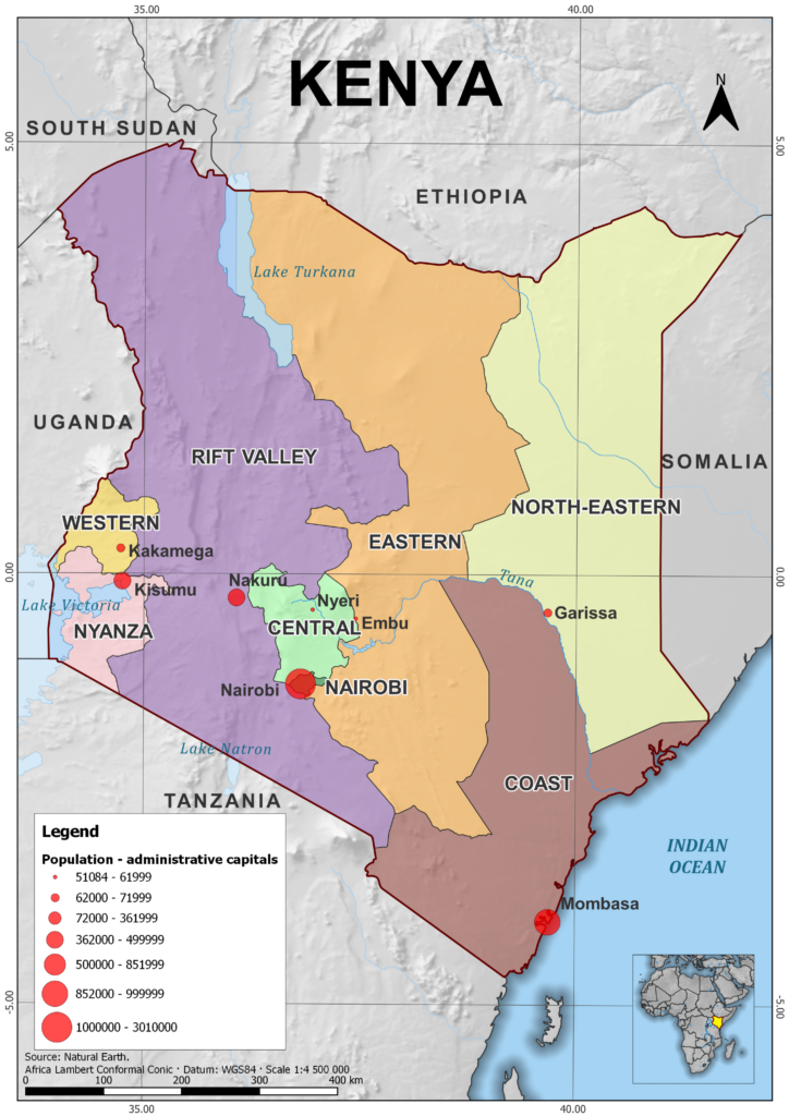
This system of counties replaced the older system of eight provinces in 2013 under a new constitution.
The eight former provinces of Kenya were:
- Rift Valley Province: The largest province, known for its stunning landscapes, which include the Great Rift Valley, a geological formation that stretches across East Africa.
- Central Province: This was an agricultural heartland, particularly for coffee and tea production, and was also home to the capital city, Nairobi.
- Coast Province: Known for its beautiful beaches along the Indian Ocean and the port city of Mombasa.
- Eastern Province: This province was characterized by semi-arid landscapes and was also home to several national parks and wildlife reserves.
- North Eastern Province: This province was the most arid, with a primarily pastoral economy.
- Nyanza Province: Named after Lake Victoria’s local name, this province was home to the Luo people and the city of Kisumu.
- Western Province: This province was characterized by lush green landscapes, home to the Luhya people.
- Nairobi Province: Essentially a city province, with the entirety of it taken up by Kenya’s capital and largest city, Nairobi.
The current system of 47 counties was designed to decentralize power away from Nairobi and promote local development. Each county has its own governor and county assembly, which are responsible for various public services.


