Key Takeaways
- A river dammed by an avalanche, then unleashed. On the morning of 26 August 2026, an ice-rock avalanche blocked the Lhende Khola on the Nepal-Tibet border, then the blockage failed, sending a wall of water down the Bhote Koshi gorge through Rasuwagadhi and Timure.
- 1,498 dead across Nepal and Tibet, and the search has been called off. The figures carried with the cabinet's 7 October decision put at least 1,455 dead in Nepal and 5,285 missing, against Nepal Police's last published bulletin, for 30 September, of 1,454 recovered and 4,718 missing with 1,334 bodies processed, DNA sampling included. The disaster authority's ledger for the same day runs to the same 1,454 retrieved but 5,285 unaccounted for, with 112 identified and 3,685 forensic samples in testing. Read the gap as two ledgers, not a correction. Xinhua has held Tibet's toll at 43 dead with 519 missing since 6 September, putting the combined death toll at 1,498 and the combined missing at 5,804. On 30 September the authority's executive committee, chaired by Home Minister Sudhan Gurung, moved the operation from search and rescue to search and recovery, with active searching left at two tunnel sites.
- Pilgrims and hydropower workers dominate the missing list. Rasuwagadhi is the main overland gateway to Tibet for the Kailash Mansarovar pilgrimage, and late August is peak season. Of the 3,916 the disaster authority listed missing on 1 September, 583 are foreign nationals from 38 countries. The disaster authority still counted nearly 900 hydropower workers among the missing on 3 September, against the projects' own ledger of 947 the day before. On 7 September the Nepali Army said only about 121 of them are believed to have gone into the tunnels at all, and that the larger number counted people attached to the projects rather than people underground. Australia now counts 42 nationals after one was located in Tibet, India listed 255 uncontactable with 84 rescued on 28 August, and 27 members of the US Congress put at least 75 Americans among the missing on 4 September. Some 13,101 people have been rescued in all, 304 of them foreign nationals. On 4 September two workers came out of the Upper Trishuli-3A tunnel alive, nine days in, but the team that then reached every section of it found one body and no one else alive, against the roughly 42 the utility had placed in its powerhouse. A Chinese worker was then brought alive out of Upper Trishuli-1 on 5 September, and a 64-year-old woman was dug out of her buried house at Betrawati the same day.
- The same river flooded 14 months ago. This is the Lhende Khola's second catastrophic flood since July 2025, when a glacial outburst destroyed the border bridge at the same spot. Scientists point to warming glaciers making these mountain dam-burst floods more frequent.
- The lake breached, the threat eased, then a second lake appeared. The barrier lake on the Nepal-China border broke its banks on 28 August and searches were suspended, but the river rose only about 0.6 metres and rescue work resumed the same afternoon. By 30 August China's water ministry said that lake had drained completely through natural outflow, and that the upper one had lost more than half its water. A second blockage upstream is the bigger one, measured at over 120,000 square metres by China's geological disaster centre, and glacial-hazards scientist Alton Byers says the debris holding it is loose and unstable.
The search is called off: the National Council for Disaster Risk Reduction and Management, chaired by Prime Minister Balendra Shah, suspended the Bhotekoshi and Trishuli search and rescue operation on Monday 5 October, 40 days in. Emergency searches can still be run.
What continues: remains or valuables turned up by reconstruction work are still to be recovered. What ends is the standing operation across the corridor.
Rs 559.17 billion for reconstruction: the same meeting, the council’s 21st, recommended that the Finance Ministry fund 504 reconstruction and rehabilitation plans submitted by ministries and agencies.
The toll on 7 October: the figures carried with the cabinet’s decision that day put at least 1,455 dead in Nepal and 5,285 missing. Nepal Police’s last published bulletin, for 30 September, stands at 1,454 recovered and 4,718 missing.
Not a death toll: out of contact is still a count of reports filed, not of deaths, and the police and the authority have never run the same ledger.
Combined: with Tibet unchanged at 43 dead and 519 missing since 6 September, the two-country totals stand at 1,498 dead and 5,804 missing.
Twelve years becomes 45 days: the cabinet on Wednesday 7 October recommended that President Ram Chandra Paudel issue an ordinance cutting the wait to declare a disaster-missing person dead from 12 years to about 45 days.
What it amends: the Disaster Risk Reduction and Management Act and the National Identity Card and Registration Act. Parliament’s session has ended, so the government is going by ordinance. Spokesperson Sasmit Pokharel called the change quite significant.
World Bank cuts the growth forecast: its Nepal Development Update, published Tuesday 6 October, puts growth this fiscal year at 3.7 percent, down from 4.2 percent in April, with a rebound to 5.2 percent in 2027-28.
Its damage line: direct damage to physical assets of $1.66 billion, 83 percent of it infrastructure, against the government’s $1.81 billion. Recovery and reconstruction needs come to $4.8 billion.
Relief fund: the Prime Minister’s disaster relief funds held Rs 17.06 billion on the Office of the Prime Minister’s latest count, reported on 8 October, including Rs 12.57 billion in nine commercial banks and $29.19 million in the dollar accounts.
Search and rescue becomes search and recovery: the disaster authority’s 37th executive committee, chaired by Home Minister Sudhan Gurung, decided on 30 September to move the Bhotekoshi operation into a recovery phase. Active searching is left at two tunnel sites.
What that changes: the centre of gravity shifts to forensic identification and rehabilitation. Chief Executive Dharma Raj Upreti said the search for the missing is still under way at two tunnels, and identification now runs through two forensic laboratories.
The toll on 30 September: Nepal Police put bodies recovered at 1,454 with 4,718 still missing, and 1,334 of the recovered bodies processed, DNA sampling included. Some 7,975 officers are deployed on recovery, relief and body management.
The authority’s ledger differs: the same meeting counted 1,454 bodies and remains retrieved but 5,285 unaccounted for, with only 112 identified and 3,685 forensic samples in testing. Read the gap as two ledgers, not a correction.
Still not a casualty count: the police list has fallen from 5,644 on 24 September as district offices verify and close names. Out of contact remains a count of reports filed, not of deaths.
Combined: with Tibet unchanged at 43 dead and 519 missing since 6 September, the two-country totals stand at 1,497 dead and at least 5,237 missing on the police count.
A way around the 12-year rule: Nepal’s Civil Code normally presumes a missing person dead only after 12 years. Instead of waiting for the courts, the committee set an administrative route: local governments certify the missing, district administration offices verify, then the authority pays relief.
What that unlocks: Upreti said on 29 September that the roughly 5,285 still missing are to be treated as deceased for relief purposes, on the social security scale of Rs200,000 for one death in a family and Rs100,000 for each further member.
Temporary housing demand: 278 families across seven municipalities have asked for temporary shelter. About 400 displaced families from Gosaikunda and 350 from other rural municipalities are living in Bidur Municipality for now.
Daily data from the Chinese side: the Department of Hydrology and Meteorology and the Chinese government have begun exchanging early-warning information, and Nepal now receives daily reports on the condition of upstream lakes and cracks.
DNA capacity: Nepalis in the United Kingdom are sending two DNA testing machines worth about $100,000, expected within days and to be handed over to Nepal Police.
At the UN General Assembly: Prime Minister Balendra Shah addressed the 81st General Assembly on Friday 25 September, calling the flood a Himalayan tsunami and putting recovery needs at about a tenth of Nepal’s GDP. It was his first foreign trip since taking office in March.
What he asked for: grant-based rather than loan-based climate finance, simpler procedures for post-disaster assistance, and a Himalayan Climate Resilience Mechanism with India and China to share satellite data, monitor glacial lakes and coordinate warnings.
What came back: no financial pledges were announced. Shah met UN Secretary-General Antonio Guterres on green reconstruction and on extending Nepal’s timeline out of least-developed-country status, and Nepal held its Sagarmatha to Sea side event the same day.
The toll on 24 September: The Kathmandu Post puts the Nepali count at 1,436 dead and 5,644 still missing. Deaths are up and the missing list is down on the 16 September figures of 1,403 and 6,150.
Still not a casualty count: the list moves in both directions as district offices verify names. Out of contact remains a count of reports filed, not of deaths.
Over 800 missing at the projects: Energy Minister Biraj Bhakta Shrestha said on Wednesday 23 September that more than 800 people attached to the hydropower schemes are still unaccounted for. Upper Trishuli-1 carries 439 of them, out of 1,433 workers on its books, with 955 rescued or since contacted.
The rest of that ledger: Upper Trishuli-3B 178, Rasuwagadhi 93, Upper Trishuli-3A 39, Langtang Khola 39, Mailung Khola seven, Rasuwa Bhotekoshi three, Trishuli three and Madhya Trishuli Ganga two, plus 47 Nepal Electricity Authority staff.
Bodies from the tunnels: 39 have been recovered from Upper Trishuli-1, one from Upper Trishuli-3A and two from Langtang Khola, and five authority employees were found dead at Chilime. Shrestha said searches run as long as there is a possibility of finding survivors.
ADB cuts the growth forecast: the Asian Development Bank trimmed Nepal’s projection for 2026-27 to 4.1 percent on Wednesday 23 September, from 4.5 percent in July, and raised its inflation forecast to 5.3 percent.
Why: the bank blames flood damage to transport, hydropower and productive assets, and the knock-on to trade, tourism and agriculture. It puts preliminary tourism losses at Rs52.67 billion and more than 430 MW off the grid, about a tenth of installed capacity.
Thursday: the highway reopens: the Krishnabhir section of the Prithvi Highway reopened to two-way traffic at 6am on Thursday 17 September, 18 days after it went into the Trishuli. Traffic runs on a 270-metre gravel track cut above the collapsed stretch.
Open, not fixed: several sections between Nagdhunga and Mugling are still down to one lane, at Shital Bazar, Jawang Khola, Galchhi, Mahesh Khola, Baireni and Malekhu. About 50 workers built the track on 12 to 16 hour shifts.
Missing list jumps to 6,150: the disaster authority raised the number unaccounted for in Nepal to 6,150 on Wednesday 16 September, up from 5,179 the day before. Spokeswoman Shanti Mahat said details were collected from the district offices and the data revised after verification.
Not a casualty count: nearly 1,000 names were added by bookkeeping, not by a fresh loss. Out of contact still is not a death toll while the list is unresolved.
The dead: bodies recovered in Nepal stand at 1,403 on Wednesday, of which 105 have been identified. Tibet is unchanged at 43 dead and 519 missing.
Combined: that puts the two-country totals at 1,446 dead and at least 6,669 missing. Nepal counts 9,287 people treated for injuries.
Foreign nationals: 607 of Nepal’s missing are foreigners from 34 countries, and Tibet’s missing include 261 foreigners from 23 countries.
Searches wound down: the Nepal Electricity Authority has halted search operations at 10 of the 13 damaged hydropower projects. Work continues only at Chilime, Upper Trishuli-1 and Upper Trishuli-3B.
Where it stopped: the halted list includes the 111 MW Rasuwagadhi, 120 MW Rasuwa Bhotekoshi, 5 MW Mailung Khola, 60 MW Upper Trishuli-3A, 14.1 MW Devighat and 14.3 MW Upper Mailung.
Ten more bodies: five were recovered from Upper Trishuli-1 and five from Chilime on Wednesday, three weeks after the flood. The Kathmandu Post counted three at Chilime earlier the same day: read the gap as bulletin timing, not a correction.
Inside Chilime: crews cleared about 1,050 metres of debris to reach the tunnel mouth, then searched roughly 130 metres in before rising water stopped the digging, army spokesperson Rajaram Basnet said.
Project missing: the Independent Power Producers’ Association Nepal counts 868 workers unaccounted for across 11 projects, down from 919 on 8 September. About 497 of Upper Trishuli-1’s 1,433 workers are among them.
Energy losses: preliminary losses across hydropower, solar and transmission are put at Rs134.69 billion, with 410.06 MW knocked off the national grid and 783.39 MW of generating capacity damaged.
The damage bill lands: the government’s rapid damage and needs assessment, reported on 15 September, puts damage and economic losses at Rs408 billion across five districts and total reconstruction at Rs723.31 billion.
Who carries it: about Rs300 billion, more than two-thirds, falls on the private sector. Hydropower and solar account for Rs151 billion of damage, commercial businesses Rs146.19 billion and housing Rs63.88 billion.
What was hit: nearly 4,800 businesses, among them 1,259 hotels and restaurants, 1,212 wholesale and retail firms and 866 educational institutions. Thirteen hydropower projects and five solar plants, 759 MW between them, were damaged.
Thursday 10 September, no new bulletin: the national count on Thursday 10 September was still the disaster authority’s Wednesday figure of 1,367 bodies recovered and 5,132 people unaccounted for. Tibet was unchanged at 43 dead and 519 missing.
Schools counted: the Education Ministry published its own tally on Thursday: 9,400 students affected across 32 schools, 3,928 of them directly hit and 1,373 displaced, with 488 students unaccounted for and five confirmed dead.
Teachers: 24 teachers and school staff are unaccounted for and one is dead. Of 527 classrooms assessed, 268 are destroyed.
Down from 622: that 488 is lower than the 622 students local education offices reported missing on 6 September. It is a verified count replacing a provisional one, not a recovery.
Scholarship bank: Education Minister Sasmit Pokharel announced a Scholarship Bank on Thursday under a Secured Future Scholarship Scheme, guaranteeing free schooling to Grade 12 for children orphaned or displaced by the flood.
Who pays: the private sector has pledged Rs 1 billion, about $6.62 million, covering 1,000 students. Support runs from residential care and full scholarships down to materials, with children who lost guardians first.
Children affected: UNICEF now puts about 22,100 children affected across Rasuwa, Nuwakot, Dhading, Gorkha and Tanahun, up from the 17,000 it estimated earlier in the month.
In the centres: the National Child Rights Council counts 1,233 children in 30 holding centres, 632 girls and 601 boys, 21 of them with disabilities. 439 are separated from their families and 102 have lost both parents.
The risk: NHRC member Lily Thapa said authorities still lack complete data on the children who lost both parents, which leaves them exposed to trafficking and sexual abuse.
Protection plan: an action plan costed at about Rs 740 million splits protection duties across agencies, with a temporary centre for parentless children planned at Thecho in Lalitpur.
Housing survey: the Department of Urban Development and Building Construction began a needs survey on Tuesday, using KOBO Toolbox forms to record damage, deaths in the family, whether households want government shelter or rent, and land for relocation.
The order of it: families in holding centres are being surveyed first, inside about a week, with families staying elsewhere assessed after that.
Power: Energy Minister Biraj Bhakta Shrestha put electricity back for 83 percent of Rasuwa and 95 percent of Nuwakot on Wednesday, with wards 10 and 11 of Bidur and Tarkeshwar-4 reconnected.
Devighat: the Nepali Army is putting a 60-metre temporary steel bridge across the Tadi at Devighat in Bidur, replacing the permanent span the flood took on 26 August.
Design under scrutiny: tunnel expert Arnold Dix said on Thursday the hydropower designs were appropriate on what was known before 26 August, calling the event possibly the first of its kind anywhere in the world.
Wednesday count: Nepal Police put bodies recovered at 1,365 and people unaccounted for at 4,077 on Wednesday 9 September, with 3,030 survivors still in holding centres and 7,975 police deployed.
Where they were found: Chitwan 363, Nawalparasi East 226, Nawalparasi West 222, Nuwakot 197, Rasuwa 174, Gorkha 75, Dhading 70 and Tanahun 38. Rasuwa is up five on Tuesday’s list and Nawalparasi East three.
The authority’s Wednesday count: the disaster authority put bodies recovered at 1,367 and people unaccounted for at 5,132 on Wednesday 9 September, with 13,646 rescued and 7,151 treated.
Still two ledgers: that is two bodies above the police count and 1,055 names above it on the missing side. Neither list is a correction of the other.
Who is on that list: 45 Nepali Army, 25 Nepal Police and 12 Armed Police personnel, 73 government employees, 26 bank and finance staff and about 589 foreign tourists.
In the centres: 3,628 displaced people are living in holding centres across Nuwakot, Dhading, Rasuwa and Kathmandu on the authority’s Wednesday figures.
Combined: add Tibet’s unchanged 43 dead and 519 missing and the two-country totals stand at 1,408 dead and 4,596 missing on the police-based arithmetic.
Identification: 1,147 bodies have been buried after DNA sampling and documentation, 1,310 are still unidentified, and police hold 2,698 DNA samples, 1,286 taken from bodies and 1,412 from relatives.
Chilime by road: the temporary track to the rescue site comes into operation on Wednesday, after helicopters were the only way in until Tuesday, and a night shift starts so the tunnel work can run around the clock.
How far in: the team is about 90 metres into the main access tunnel with roughly 95 metres left before the main rock formation, and the powerhouse sits about 200 metres in. Six people are thought to be inside.
A familiar face: Kulman Ghising, former executive director of Chilime and a former energy minister, is at the site coordinating and giving technical guidance at the Nepali Army’s request.
Health insurance: the Health Insurance Board has removed co-payments and treatment caps for three months in Rasuwa, Nuwakot and Dhading, and insured people can be treated on a verified insurance number without producing a card.
Climate money: fourteen board members of the UN loss-and-damage fund have now written to its co-chairs asking for an emergency meeting on Nepal, against a next regular meeting in December.
Parliament: the House of Representatives Finance Committee formed a seven-member subcommittee under MP Sushil Khadka on Wednesday to study the flood’s economic impact and climate finance, reporting by 18 September.
In the House: Rastriya Swatantra Party chair Rabi Lamichhane addresses the House of Representatives at 1pm on Wednesday on the search, rescue, relief and rehabilitation effort.
Tuesday count: the joint command of the security forces put bodies recovered at 1,357 and people unaccounted for at 5,326 on Tuesday 8 September, with 13,583 people rescued.
Where they were found: Chitwan 363, Nawalparasi East 223, Nawalparasi West 222, Nuwakot 197, Rasuwa 169, Gorkha 75, Dhading 70 and Tanahun 38. Those eight districts account for every body on the Nepali count.
Named at last: 102 of the recovered have been identified and handed back to their families, against 96 on Friday. The rest are still going through DNA and documentation.
Two ledgers still: Nepal Police’s own last published bulletin, for Sunday evening, stands at 1,353 recovered and 3,992 missing. Read the gap as two ledgers, not a correction.
Bridges: the Department of Roads counts 41 motorable bridges destroyed between Rasuwa and Chitwan and four more damaged, leaving 18 of the 63 on that corridor intact.
The road bill: the same department puts the damage to roads and bridges at about Rs30 billion, and rebuilding them at about Rs50 billion.
Bailey bridges: seven are needed between Rasuwagadhi and Syabrubesi. China has sent two 100-metre spans to Korala in Mustang, about 320 tonnes moving on 17 trucks with two technicians, roughly a week from delivery. India has offered, and nothing has arrived.
Krishnabhir: more cracks than expected have opened about 50 metres above the bypass track, says roads director general Bijaya Jaishi. Engineers want immediate slope treatment, with a tunnel or a bridge over the Trishuli as the permanent fix.
When it opens: officials are targeting traffic on the temporary track within about two weeks. The Prithvi Highway normally carries about 12,000 vehicles a day.
Three options: the Department of Roads is weighing whether to reopen the existing Krishnabhir section, drive two 500-metre tunnels behind it, or throw two permanent bridges across the Trishuli and run the highway up the far bank.
A week to decide: director general Bijaya Jaisi said on Wednesday the department will settle within a week whether vehicles can run through Krishnabhir at all. Dashain traffic starts next month.
The detours meanwhile: a 20-kilometre run from Galchhi up the opposite bank to Parewatar, and a 17.5-kilometre link from the Fishling bridge in Chitwan to the Benighat bridge in Dhading, of which about 1.5 kilometres is still bad road.
Cholera: the Ministry of Health and Food Hygiene sent 80,523 doses of cholera vaccine to Nuwakot on Tuesday. Rasuwa’s campaign starts on Thursday, its doses already flown in by helicopter.
Tibet: Xinhua held the Chinese toll at 43 dead and 519 missing on Tuesday, and said none of the bodies recovered there so far are foreign nationals, against 261 foreigners from 23 countries on its missing list.
Tourism: hotel occupancy in Chitwan has fallen below 5 percent, Pokhara reports up to 30 percent of bookings cancelled and Lumbini is losing reservations that run through November. None of those places was flooded.
Crypto: Nepal bans cryptocurrency, so donations are converted to dollars abroad by Cross River Bank and wired in. NepalRelief.org had taken $174,831 by Tuesday, with about $500,000 converted in all.
Monday bulletin: Nepal Police put the bodies recovered at 1,353 and the people unaccounted for at 3,992, on the count for Sunday evening released in the early hours of 7 September.
The authority’s Monday count: the disaster authority put bodies recovered at 1,355 across eight districts and people unaccounted for at 4,996 on Monday afternoon, with 13,396 rescued and 6,672 injured treated.
Where the missing sit: 2,340 of them are from Nuwakot and 1,967 from Rasuwa, including 589 foreign nationals and about 100 security and government personnel.
Downstream districts: on that count Chitwan holds 363 of the bodies, Nawalparasi East 222 and Nawalparasi West 221, all far below the gorge where the flood began.
The response: more than 21,000 security personnel are deployed, 9,287 army, 7,912 police and 4,203 armed police, with about 1,500 helicopter flights flown and 3,500 displaced people in 39 holding centres.
Services: the authority puts electricity back for 78 percent of Rasuwa and more than 96 percent of Nuwakot, with 98 percent of mobile towers working again.
What is in that: 530 of the recovered are men and 328 women, while 495 came out as partial remains that stay unidentified. 1,044 have now been buried after documentation.
Who is missing: police spokesperson Abi Narayan Kafle lists 2,827 Nepali men and 567 Nepali women, with 267 foreign men and 239 foreign women. 9,159 people have been rescued and 3,190 are in holding centres.
Combined: Tibet is unchanged at 43 dead and 519 missing, so the two-country totals stand at 1,396 dead and 4,511 missing.
A second count: AFP put the combined toll at at least 1,385 dead and more than 5,500 missing on Monday, working from the disaster authority’s longer missing list rather than the police one. Read the gap as two ledgers, not a correction.
Day of mourning: Nepal observed a national day of mourning on Monday 7 September, the thirteenth day after the flood and the day Hindu rites formally close mourning, with flags at half-mast at government offices and Nepali missions abroad.
Gen Z Martyrs’ Day: Nepal marked the holiday on Tuesday 8 September, a year after the protests that brought the current government in, with a commemoration at the Prime Minister’s Office.
Still a rescue: army spokesman Raja Ram Basnet said searches are going on with the same tempo as day one, at three levels: on the ground, by air and in the tunnels.
Rasuwagadhi opens up: the Energy Ministry says rescue teams have now reached the Rasuwagadhi powerhouse, the route that had been blocked short of it, with mud pumps and generators airlifted to the sites.
Far fewer underground: Brigadier General Subash Jung Thapa told a disaster authority press conference on Monday that the army has evidence only 121 people entered the hydropower tunnels, not the roughly 900 on the project lists.
Not better news: Thapa said workers caught outside the tunnels are still unaccounted for, so the projects’ final toll may run above 121. The army puts the speed of the water and debris at about 180 kilometres per hour.
Tuesday underground: a joint team with foreign technicians is about 400 metres into the main access tunnel at Upper Trishuli-1, and about 115 metres into Chilime, where a rock blocking the approach road has been blasted out.
Still 95 metres: that is what is left at Chilime before the next major obstruction, with four six-metre pipes used to open the route and winches and buckets pulling out the debris.
The other sites: 34 army and four armed police are working the Trishuli-3A powerhouse, 101 soldiers with three excavators have dug about 23 feet around the Upper Trishuli-3B offices and quarters without finding anyone, and a drone located one body in the Ronga cable tunnel at Rasuwa Bhotekoshi.
Project missing: the Tuesday tally across the 11 damaged projects in Rasuwa and Nuwakot is 919 workers unaccounted for, down from 942 on Friday and 947 the Wednesday before.
Tunnel by tunnel: teams have reached the Rasuwagadhi powerhouse and control room, cleared Audit-2 at Upper Trishuli-3B and found nobody, and are searching Upper Trishuli-1 with thermal imaging cameras.
Until it is finished: the army says the search will run until every tunnel has been broken through and searched, unless the government calls the operation off.
Chilime: Arnold Dix, who advised the Silkyara tunnel rescue in India, arrived on Saturday and is working the Chilime tunnel with Nepali and Indian teams under Colonel Parikshit Mehra.
Getting in: Indian ambassador Naveen Srivastava says a rope link is being strung from Syabrubesi to the tunnel and about 950 metres of temporary road has been cleared.
Power: 99.8 percent of households in Dhading and 96.7 percent in Nuwakot have supply back, with a Nepal Electricity Authority team still working Rasuwa.
Solar instead: 13 solar systems for offices and 500 household units have been flown in, with 1,268 more household systems planned for Rasuwa.
Cut off: Aamachhodingmo Rural Municipality in Rasuwa, home to more than 7,000 people, is reachable only by helicopter and is out of rice, potatoes, salt, oil and medicines. At least 203 of its residents are missing.
Schools: 65 of Bidur Municipality’s 79 schools reopen on Wednesday 9 September, 14 days on. Five were destroyed outright, nine more damaged and nine are being used as displacement centres.
Farmland: the disaster authority counts 1,806 hectares of farmland wrecked and expects 7,686 tonnes less food from the affected areas. Six farmers on an indigenous-crop project are among the missing.
Online abuse: the Cyber Bureau has formed a 10-member team to trace people posting hateful or demeaning comments and AI-generated fakes about flood survivors, after a warning from Prime Minister Balendra Shah.
Washington: US Secretary of State Marco Rubio called Rastriya Swatantra Party chair Rabi Lamichhane on Monday to offer condolences and further American support.
Sunday bulletin: Nepal Police Headquarters issued an update timed at 7:40am on 6 September: 1,341 bodies recovered and 4,044 people missing, a fall of more than 850 on Saturday’s list.
Who was on it: 3,438 of those missing were Nepalis and 606 foreign nationals. 9,151 injured or rescued people had been brought out, and 3,098 were living in holding centres.
Tibet moved: Xinhua raised the Chinese toll to 43 dead with 519 missing as of 6pm on Saturday, the largest single revision on the Chinese side.
Two more found: two unidentified bodies were recovered inside the Upper Trishuli-1 tunnel on Sunday, a day after a Chinese worker was pulled out alive from about 225 metres in.
Chilime reopens: a rescue operation was launched at the 22 MW Chilime project on Sunday after six people were reported trapped in its tunnel, led by chief executive Babu Raja Maharjan.
Drones carrying food: resupply by drone began in Rasuwa, with 664 kilograms flown into Hankubensi over 12 trips. District police there now count 169 bodies collected.
Gear requested: the foreign ministry has asked for LiDAR, ground-penetrating radar, high-capacity surge pumps, inflatable walkways and DNA kits. An 11-member Malaysian team with nine drones has joined the tunnel work.
Power back: the Nepal Electricity Authority says supply has been restored across more than 75 percent of the flood zone, with Nuwakot around 95 percent and Rasuwa 75 to 80 percent, and about 300 MW still offline.
Flag back at Timure: a joint army, police and armed police team walked a 3-kilometre cliff route to re-hoist the national flag on the border line at Gosaikunda Rural Municipality-2.
An official goes: the Home Ministry recalled Rasuwa chief district officer Narendra Pariyar, less than two months into the posting, after criticism of the district administration’s coordination. Kamal Prasad Pandey replaces him.
Trekking suspended: Gorkha’s district administration halted trips on the Manaslu Circuit and Larke Pass after Sunday’s flash flood at Chumnubri, which also took a suspension bridge over the Budhigandaki.
Vaccine in: a Nepali Army helicopter flew 21,000 doses of cholera vaccine into Rasuwa on Sunday morning, obtained with WHO support, after damage to drinking water systems raised the risk of waterborne disease.
A fresh flood: the Namrung stream burst its banks at about 3am on Sunday in Chumnubri Rural Municipality-4 of Gorkha, taking four houses and the iron bridge between wards 4 and 2. No casualties were reported.
Krishnabhir, partly: the temporary track above the collapsed Prithvi Highway section is open but restricted to construction traffic, now 350 metres long and four metres wide, about 20 metres above the old road.
When it reopens: seven excavators, a JCB, a loader and two bulldozers are widening it. Public transport is targeted for mid-September, not the coming week.
And shut again: the Parewabhir section at Gajuri-2 in Dhading was closed from 6am to 6pm on Sunday for repairs, with only ambulances and hearses let through.
Donations: the Prime Minister’s Disaster Relief Fund and the Prime Minister’s Relief Fund held Rs 11.77 billion between them at 9am on Tuesday, most of it paid in by QR code and card rather than over a bank counter.
Where it sits: Rs 8.59 billion is in nine commercial banks and Rs 211.08 million in the dollar accounts at Himalayan Bank and Laxmi Sunrise. Rs 1 billion has been released to the disaster authority for Rasuwa.
Mourning: the cabinet has declared Monday 7 September a national day of mourning, with the flag at half-mast at government offices and at Nepali missions abroad.
UN appeal: the UN and its partners launched a $49.6 million appeal on 4 September, covering four months and aimed at more than 84,000 people, under the disaster authority’s lead.
Assessment: a panel under National Planning Commission vice-chair Gunakhar Bhatta has six weeks to deliver the post-disaster needs assessment, working from a Rs 400 billion estimate.
Two searches closed: Friday’s project review puts 942 people unaccounted for across 11 hydropower projects, with the Trishuli-3A search called off and the Langtang Khola teams withdrawn.
Saturday afternoon: a Chinese worker was brought alive out of Audit Tunnel 4 at the Upper Trishuli-1 project at about 1:20pm, ten days after the flood, by the Nepali Army and a Korean disaster response team.
And at Betrawati: Chandrika Shrestha, 64, was found alive inside her mud-filled four-storey house in Bidur-1, Nuwakot, after a police squad heard a faint cry for help. She was airlifted to Birendra Military Hospital.
Saturday: Nepal Police put the bodies recovered at 1,344 in its 5 September bulletin, with 4,898 people still unaccounted for.
The other agency: the disaster authority’s Saturday count is 1,331 dead and 4,996 missing, 589 of them foreign nationals, with 13,101 people rescued including 304 foreigners.
Two numbers again: the Kathmandu Post reported the same police bulletin, timed at 8am Saturday, as 1,342 dead and 4,886 missing. Read the gap as bulletin timing, not a correction.
Buried: 1,030 of the recovered bodies have now been interred after documentation: 222 women, 355 men and 453 whose sex could not be established.
DNA: 2,272 samples have been collected in all, 1,260 from bodies and 1,012 from relatives, and the details of 1,270 unidentified people are on the Nepal Police website for families to check.
Two found alive: Sanjay Sah, a 30-year-old mechanical foreman, and Kabir Maharjan, a 45-year-old mechanical supervisor, were brought out of the Upper Trishuli-3A tunnel alive on Friday morning, nine days after the flood.
Where they were: both were found along the route leading to the powerhouse, which the rescue team has still not reached. Project chief Awas Ojha says the number of people still inside remains unclear.
What they said: Sah told rescuers everyone inside was safe. The Nepal Electricity Authority still puts about 42 engineers and staff in the powerhouse, and Home Minister Sudan Gurung called the rescue a ray of hope.
Both airlifted: Sah was taken to Birendra Army Hospital in Chhauni and Maharjan to the National Trauma Centre in Kathmandu, their condition reported as normal at the site.
Then nothing more: a seven-member Armed Police Force team crawled through Trishuli-3A for 15 to 20 minutes on Friday and says it reached every section, including the farthest point, finding one body and no one else alive.
Halt requested: team member Ambar Mahat said they did not hear any other voices, and the station chief has asked for the search there to stop while staff review possible locations. The utility had put about 42 people in that powerhouse.
Nepal: the police count of bodies recovered stands at 1,353 on the Sunday-evening tally released early Monday, up from 1,341 on Sunday morning and 1,344 on Saturday.
Combined: add Tibet’s 43, unchanged since Xinhua’s Sunday report, and the toll is 1,396. It is Nepal’s deadliest natural disaster since the 2015 earthquake.
Two agencies: the authority issued two figures on Friday alone, 1,287 at midday and 1,294 in the evening, both above Wednesday’s police count of 1,127. On Saturday the order flipped: the authority is at 1,331 and the police at 1,344.
How wide: the government’s first situation report counts nearly 1.6 million people affected, with the 3,916 missing reported from 62 districts.
Missing: the police list falls again to 3,992 on the Sunday-evening count, from 4,044 on Sunday morning, 4,898 on Saturday and a 5,083 midday peak on Friday. Add Tibet’s 519 and the police-based figure is 4,511.
Why it swings: the list counts reports filed, not deaths. It jumped as families reached district centres, then fell as names were traced alive or moved onto the recovered list.
Where the bodies are: on the police bulletin for Saturday, 360 in Chitwan, 230 in Nawalparasi West, 222 in Nawalparasi East and 192 in Nuwakot, with 73 in Gorkha, 67 in Dhading and 38 in Tanahun.
Rasuwa rises: the district where the flood started now accounts for 160 of the bodies on Saturday’s police bulletin, up from 140 the day before.
And nine in India: the police count carries a separate line for bodies recovered across the border, at nine.
Where the missing are: Friday’s midday bulletin puts about 2,340 in Nuwakot and about 2,130 in Rasuwa, with 583 foreign nationals on the list.
Officials and troops: 147 of the missing are local representatives, government staff, teachers and security personnel. Security personnel account for 83 of them: 45 army, 25 police and 13 armed police.
Hydropower tunnels: the project-by-project count on Wednesday puts 947 people unaccounted for across the damaged schemes in Rasuwa and Nuwakot.
Underground recoveries: four bodies have now been brought out of three mud-filled tunnels, one more than on Monday. Still no contact with anyone alive inside.
Project by project: Upper Trishuli-1 lists 557 missing against 254 rescued, and Upper Trishuli-3B still 191, where three small excavators are digging without having found the buried project building.
The smaller sites: Rasuwagadhi has 93 missing, Langtang Khola 41 feared trapped and Chilime eight.
How far they have got: a joint team is drilling through the Trishuli-3A outlet tunnel and has not reached the powerhouse. At Rasuwagadhi the passage is completely blocked short of it, and at Chilime the essential equipment has still not arrived.
Langtang: two bodies were brought out of the Langtang Khola tunnel on Thursday, reached about 150 metres in through the project’s empty penstock pipe after the main route stalled at 100 metres.
Trishuli-3A: two excavators have cleared roughly 20,000 cubic metres of debris from the cable duct in five days, with about three metres left before an access and drainage passage opens.
Hopes dimming, then Friday: Nepal’s National Emergency Operation Center said a week on that the chance of finding survivors was decreasing. Two men then walked out of Trishuli-3A alive.
Still a search: American specialists have joined the Indian and Chinese teams on the tunnels, and the operation is being run as a rescue rather than a recovery.
On site: about 10,000 Nepali troops are on the tunnel operation with Chinese and Indian specialists. Australian tunnel engineer Arnold Dix argues an intact powerhouse would give anyone inside air and water.
Brought out alive: 208 people were pulled from the Trishuli-III tunnel on 29 August, 43 of them foreign nationals, among those 38 Chinese and five Indians.
Rescue: the authority’s Saturday count is 13,101, including 304 foreign nationals, up from 13,095 on Friday evening and roughly 11,900 on Thursday.
By air: the Nepali Army has now airlifted 4,364 people on 715 helicopter flights, 273 of them foreign nationals, with 129 more flights flown by private operators.
A third count: Nepal Police logs 8,631 injured and affected people rescued on its Saturday bulletin, a narrower measure than the authority’s 13,095, with 3,655 people still in holding centres.
Injured: 5,397 injured survivors have been treated in hospitals on Friday’s bulletin, up from 5,135 on Thursday.
Shelter: 4,627 displaced people are living in 37 holding centres across Rasuwa, Nuwakot and Dhading on Friday’s bulletin.
Barrier lakes: the lower lake has drained completely, but China warned on 31 August of a continuing risk from fresh glacier collapse and new water build-up on the border.
What they are watching: an impact crater 5.6 kilometres upstream, at about 3,700 metres, covering roughly 108,000 square metres and holding about 1.4 million cubic metres of water on 30 August.
Fresh alerts: Nepali forecasters flagged a high chance of flash floods in Nuwakot and Rasuwa on 1 September, with moderate risk across much of central, eastern and western Nepal.
Still raining: the Weather Forecasting Division said on Saturday the monsoon will stay active for three more days, with heavy falls possible at one or two places in the hills of Koshi and Bagmati, which covers the flood zone.
Roads: at Krishnabhir a 70-metre section of the Prithvi Highway has gone into the Trishuli, with 120 metres more badly cracked, and traffic is running through Hetauda instead.
Langtang cut off: the valley is severed from Dhunche, leaving 116 households and about 450 residents reachable only by helicopter or a two-day walk. Its health post says medicines last until Dashain.
A second cut: the same highway was blocked again on Wednesday when a three-metre-wide section sank at Pataleban, just past the Nagdhunga checkpoint, with small vehicles sent through the Nagdhunga tunnel.
Trade: Tatopani is shut to goods, leaving Korala in Mustang as the only working overland trade route to China. Between 70 and 75 loaded containers were swept out of Rasuwagadhi customs and 170 more are stranded at Kerung.
Damage: Finance Minister Swarnim Wagle puts rebuilding at $4bn to $5bn, close to a tenth of Nepal’s economy. The Nepal Electricity Authority says 431 MW is off the national grid.
A first official figure: the disaster authority put preliminary losses at Rs 387.54 billion on Friday, with about Rs 8 billion needed over the next four months for restoration.
Debris: UNDP’s preliminary assessment on Wednesday puts the wreckage at 2.2 million tonnes, including 556,200 tonnes from 2,359 damaged buildings.
Money: Nepal filed its first ever claim on the UN loss-and-damage fund on 1 September. Australia’s package is now $8 million, with an air force C-17A flying supplies in.
Shelter: more than 10,000 households now need emergency shelter, and dignity kits are being distributed to women and girls in the affected districts.
Women and girls: UN Women counts 43,000 needing urgent help, out of 157,050 affected in Rasuwa and Nuwakot, and has asked for $2 million.
Aid total: more than $42 million has been pledged to Nepal, and relief distribution in Rasuwa and Nuwakot has passed to the local governments.
Bangladesh: a $1 million contribution to the Prime Minister’s Disaster Relief Fund was handed over on Friday, with a letter from Prime Minister Tarique Rahman to Balendra Shah.
Nvidia: the chipmaker and co-founder Jensen Huang put $10 million into the same fund on Friday, one of the largest corporate donations Nepal has received, pushed internally by more than 50 Nepali employees.
Twenty-nine countries: the foreign ministry counts 29 governments plus the EU, the Asian Development Bank, the World Bank and the UN providing relief or money, with forensic teams from India, China, Singapore and South Korea on identification.
Water: five of 15 drinking water samples in Bidur, Nuwakot came back positive for E. coli on Friday. The contingency plan covers cholera vaccine for 100,000 people and measles and rubella vaccine for 75,000 children, and the first 21,000 cholera doses reached Rasuwa on Sunday.
Tunnels on Tuesday: search teams are about 200 metres into Upper Trishuli-1, around 150 metres into Langtang and about 50 metres into Chilime, with water being drained and air pumped at Upper Trishuli-3A.
Tibet: Xinhua raised the Chinese toll to 43 dead at Gyirong Port as of 6pm on Saturday, with 519 missing, up from 31 dead and 531 missing the day before.
Searching there: crews have recovered 987 personal belongings by Friday, having covered 1.591 million square metres, working debris four metres deep on average and up to 16 metres in places.
Power back: Xinhua’s Friday factbox says electricity has been restored to the core disaster area, hours before the evening revision to 31 dead.
Chinese forensics: relief supplies and DNA experts had been sent on to Kathmandu by Thursday, with more than 2,300 rescuers still deployed and 336 of them in the core zone.
Road back in: China reopened the G216 highway to Gyirong Port at 10am on Wednesday, the first road access to the core disaster zone since 26 August.
What that changes: heavy machinery and supplies can go in by road instead of by airdrop, and crews with life-detection gear and search dogs are working the crossing and the riverbanks.
Identifying the dead: 96 bodies had been handed back to relatives by Friday, against 1,344 now recovered. By Saturday 1,030 had been buried after documentation, with 1,270 unidentified people logged on the police website.
DNA appeal: Nepal Police has called first-degree relatives of the missing to give blood samples at its hospital in Maharajgunj or their district police office.
Families abroad: they are asked to obtain autosomal STR DNA profiling from a forensic laboratory and email the report with the missing person’s passport details and the date and place they were lost.
The alert: the government’s text warning went out at 9:15am on 26 August, 38 minutes after the collapse and 25 minutes after the flood had already destroyed the river gauge at Syabrubesi.
Seen in advance: a rapid hazard assessment by the HiRISK group found pre-event indications in satellite imagery days earlier, among them a change in the glacier surface and a crack running into the bedrock.
Funerals without bodies: families in Paharebesi, in Rasuwa’s Uttargaya Rural Municipality, have begun last rites for missing relatives before the 13-day Hindu deadline. About 54 people are missing from that settlement alone.
Krishnabhir: tree-cutting started on Thursday to open a path for excavators at the collapsed Prithvi Highway section, with 18 workers on the two faces and machinery waiting.
Knock-on: LPG cylinders are being filled outside the Kathmandu Valley because of the highway break, and traders report artificial shortages in the markets.
Japan: Ambassador Maeda Toru handed blankets, tents, sleeping pads, plastic sheets and jerry cans to Minister Mahabir Pun at Kathmandu airport on Thursday.
China again: a third batch of relief flew in on a PLA Air Force Y-20A on Thursday afternoon, carrying mortuary freezers, epidemic-prevention materials, daily necessities and Bailey bridges, along with 10 more forensic experts.
Europe: the EU added Rs89 million on Thursday, taking its total to more than Rs445 million, aimed at up to 20,000 people in Bagmati through the Red Cross.
Krishnabhir: about 50 metres of the bypass track above the collapsed Prithvi Highway stretch had been opened by Friday, wide enough only for excavators. The full track is still expected to take 10 to 15 days.
Tatopani: 114 Nepalis stranded in China came back through the crossing on Thursday, out of 147 expected. Tourist movement there is open, trade and customs are still suspended.
Still a rescue: tunnel expert Arnold Dix says silence underground is not evidence of death, only the absence of a signal, and that the tunnels are sheltered and thermally stable.
River warning: forecasters kept the Bhotekoshi and Trishuli at high risk of flash flooding on Thursday, with rain still falling in the upper Bhotekoshi.
Rain on Friday: the Department of Hydrology and Meteorology warned of heavy rain over the flood zone that afternoon, with meteorologist Binu Maharjan flagging the hills of Rasuwa.
Three-day outlook: heavy falls are possible at scattered spots in the mountains of Koshi, Bagmati and Gandaki, with moderate rain elsewhere in the affected districts.
Homes gone: Friday’s bulletin counts 7,570 houses destroyed, affecting 32,933 people, along with 48 government buildings, 18 schools and seven health facilities.
Where they go next: the government is mapping about 15 settlements in Rasuwa, Nuwakot and Dhading that may no longer be habitable.
Children: about 600 students are unaccounted for, 280 in Rasuwa and between 300 and 350 in Nuwakot, along with 22 teachers and school staff.
Schools: twelve were destroyed outright, four in Rasuwa and eight in Nuwakot, and more than 7,000 students are affected. Five local units have suspended classes.
Tourism: a #NepalCalling campaign launched on Thursday to separate Rasuwa from the rest of the country after a wave of booking cancellations.
Caveat: every figure here is provisional and moving fast. Out of contact is not a death toll: roads and phone links are gone, and many of the missing are alive but unreachable.
The swings measure reports filed and reports resolved, some of them by a name moving onto the list of the dead.
A flash flood tore down the Bhote Koshi gorge on Nepal’s border with Tibet on the morning of 26 August 2026, sweeping away the Rasuwagadhi border post, bridges, hydropower plants and stretches of the only road that links Kathmandu to Tibet overland.
At least 1,455 bodies have been recovered in Nepal on the figures carried on Wednesday 7 October, and 43 more people are confirmed dead in Tibet, taking the combined toll to 1,498 on that arithmetic.
That is up from the 1,454 both the police and the disaster authority carried on 30 September. The dead are still being found six weeks after the flood, most of them far downstream.
5,285 people are on the missing list on the Nepali side on 7 October and 519 in Tibet, among them pilgrims and trekkers bound for Mount Kailash and hundreds of hydropower workers.
That Nepali figure is the disaster authority’s. Nepal Police’s own last published bulletin, for 30 September, carries 4,718, and the two agencies have never run the same ledger.
That Nepali figure jumped by nearly 1,000 names on 16 September, from 5,179 the day before. Disaster authority spokeswoman Shanti Mahat said the details had been collected from the district offices and the data revised after verification.
It is a bookkeeping revision, not a fresh loss. Out of contact is still not a casualty count while the list is unresolved, and the police and the authority have never run the same ledger.
Of the Nepali missing, 607 are foreign nationals from 34 countries, and 9,287 people have been treated for injuries. Tibet’s 519 missing include 261 foreigners from 23 countries.
The disaster authority’s longer list stood at 5,326 on 8 September, when 13,583 people had been rescued. The two lists have never matched, and neither is a correction of the other.
Nearly 1.6 million people have been affected. It is Nepal’s deadliest natural disaster since the 2015 earthquake, which killed about 9,000.
The two-country total depends on which ledger you take. AFP reported at least 1,385 dead and more than 5,500 missing on 7 September, using the disaster authority’s longer missing list. The police-based arithmetic gives 1,396 dead and 4,511 missing.
Nepal Police’s bulletin for 9 September puts 1,365 bodies recovered and 4,077 people missing, above the joint command on the dead and well below it on the missing.
The disaster authority published its own Wednesday count later the same day: 1,367 bodies recovered and 5,132 people unaccounted for, with 13,646 rescued and 7,151 treated.
That is two bodies above the police figure and 1,055 names above it on the missing side. Out of contact is still not a casualty count, and the two lists have never been reconciled.
The authority also broke the list down. It counts 45 Nepali Army personnel, 25 Nepal Police, 12 Armed Police, 73 government employees, 26 bank and financial staff and about 589 foreign tourists among the missing, with 3,628 displaced people in holding centres in Nuwakot, Dhading, Rasuwa and Kathmandu.
The police list has risen by 12 bodies since Sunday evening and by 85 names on the missing side. The disaster authority’s Monday figures were 1,355 and 4,996, with 13,396 rescued.
None of these counts is a correction of the others. The missing lists count reports filed, and the police and the authority keep separate ones.
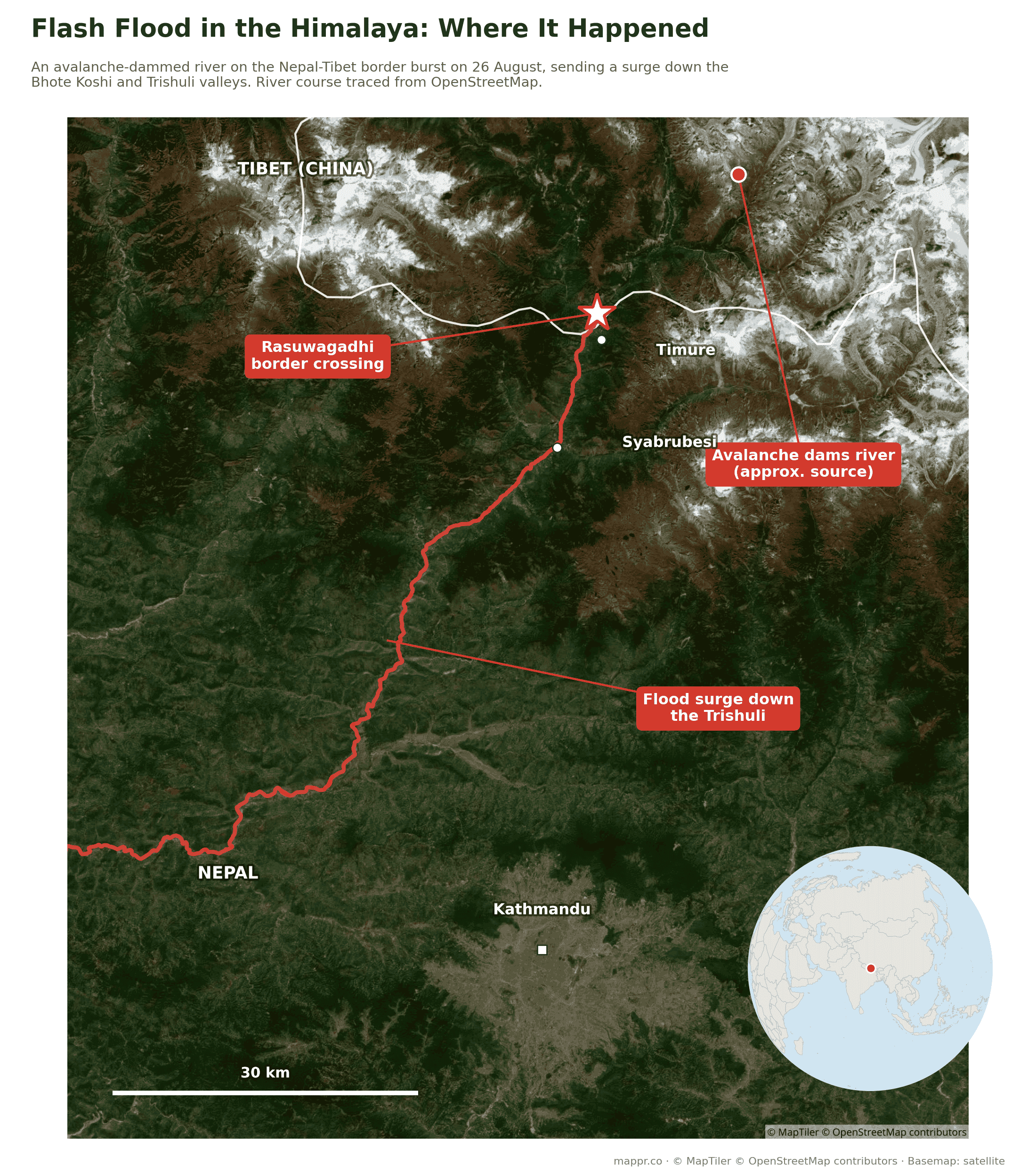
The surge began high in the Lhende Khola, a tributary that joins the Bhote Koshi right at the Rasuwagadhi border crossing. From there the wall of water ran south through Timure, the trading village that serves the border, past Syabrubesi, the trailhead town for the Langtang treks, and onward down the river system toward Trishuli Bazar, damaging homes, roads and power projects along roughly 60 kilometres of valley.
Satellite images released by Planet Labs on 27 August show what that meant on the ground: buildings and roads scoured away at Timure and Rasuwagadhi, and the trekking hub of Syabrubesi left submerged in mud.
The pulse did not stop at the alert line. By 27 August bodies were being recovered from the Trishuli and Narayani riverbanks in Chitwan, out on the plains, and in Nuwakot, Dhading, Gorkha, Tanahu and both Nawalparasi districts.
Chitwan alone accounts for 360 of the bodies on Nepal Police’s bulletin for 5 September, with 230 more in Nawalparasi West, 222 in Nawalparasi East, 73 in Gorkha and 67 in Dhading.
Nuwakot has 192, Tanahun 38 and Rasuwa 160. Nine more bodies have been recovered in India.
Rasuwa itself, the district where the flood started, accounted for 160 of the bodies in Saturday’s tally, up from 140 a day earlier and from the 45 carried on Wednesday’s police bulletin.
The district’s own count runs slightly ahead. Rasuwa district police chief Ashok Thapa put the bodies collected from flood-hit areas there at 169 on 6 September, with remains from Ghattekhola in Timure, Haku and Dandagaun airlifted to Bidur on six helicopter flights.
Most of the dead were still found far downstream. Recovery in the upper gorge only became possible once crews could work the riverbanks around Timure and Syabrubesi.
The recovery has outrun the morgues. Chitwan’s hospitals hold 30 to 50 bodies between them against more than 137 recovered locally, and Pokhara has taken 93 against a capacity of 88.
Authorities are converting a building in Bharatpur into a temporary centre for about 250 bodies, cooled with air conditioning and dry ice. Police are photographing remains and taking fingerprints and DNA, with testing in Kathmandu.
That timeline collapsed. Burials of unidentified victims began on Saturday 29 August, when authorities interred 229 bodies at Devghat, in ward 1 of Bharatpur Metropolitan City in Chitwan.
Only four of the 233 bodies recovered in Chitwan had been identified. Police inspector Anil Thapa said DNA was taken from every body first, and each was tagged with a numbered steel plate so relatives can exhume them once a match comes through.
Across the disaster as a whole the picture is the same. Of the first 669 bodies recovered, just 20 had been identified by relatives, and 211 arrived as partial, mutilated or severed remains.
The backlog has since grown with the recovery. By 1 September, 726 of the bodies were still unidentified and 413 had been temporarily interred after DNA samples were taken, well beyond the 229 buried at Devghat on the Saturday.
It grew again overnight. The police count on 2 September put 911 bodies as still unidentified, with postmortem work completed on 1,113 and only 95 handed back to relatives.
By 3 September the gap had widened further. Of the 1,252 bodies recovered, 1,157 remain unidentified, and the number handed back to families is still 95.
A day later it had barely moved. Of the 1,294 bodies recovered by the evening of 4 September, only 96 had been identified and returned to relatives, one more than the day before.
The response has now cost an official his post. On 6 September the Home Ministry recalled Rasuwa chief district officer Narendra Pariyar, less than two months into the job, after the district administration’s handling of search, relief and coordination was publicly questioned by the local customs chief.
Kamal Prasad Pandey, a director at the Department of National ID and Civil Registration, has been named to replace him.
South Korea sent its foreign minister. Cho Hyun met Foreign Minister Shisir Khanal in Kathmandu on 6 September over nine missing South Koreans, workers for Doosan Enerbility and Korea South-East Power at Upper Trishuli-1.
Cho pledged 130 million won in relief supplies and $1 million in humanitarian aid, alongside continued rehabilitation support and climate advocacy at international forums.
Washington called the next day. US Secretary of State Marco Rubio spoke to Rastriya Swatantra Party chair Rabi Lamichhane on 7 September, offering condolences and saying the United States was ready to provide additional support.
Lamichhane said the government was mobilising all available resources for search, rescue and relief, and gave an assurance on the protection of foreign nationals as well as Nepali citizens.
By 5 September the burials had overtaken the identifications. Nepal Police say 1,030 of the 1,344 bodies recovered have now been interred after documentation, among them 222 women, 355 men and 453 whose sex could not be established.
Each one carries a code number recorded both at the burial site and in the case file, alongside photographs, a DNA sample, an autopsy report and a GPS location, so relatives can claim them later.
The sample bank is the bottleneck now. Police count 2,272 DNA samples in all, 1,260 taken from bodies against 1,012 from relatives, and the details of 1,270 unidentified people have been uploaded to the Nepal Police website.
On 4 September the police put out a formal appeal to close that gap. First-degree relatives of the missing are asked to give a fresh blood sample, in person, at the Nepal Police Hospital pathology lab in Maharajgunj or their nearest district police office.
Families abroad have a separate route. Parents or children are asked to obtain autosomal STR DNA profiling from an official forensic laboratory and email the report to Nepal Police with the missing person’s passport details and the date and place they were last seen.
On 5 September the collection moved closer to the families. A DNA sample collection centre opened at the Nepal Police Hospital in Bidur, in Nuwakot, so relatives no longer have to travel to Kathmandu, Deputy Inspector General Damodar Paudel said.
It is starting to tell. Police counted 2,472 DNA samples by the morning of 6 September, 1,286 taken from bodies and 1,186 from relatives, against 2,272 the day before.
The identification gap has barely moved even so. Of the 1,341 bodies recovered, 1,037 have been buried after documentation and 98 handed back to relatives, leaving 1,297 still unidentified.
By Sunday evening the burial count had risen again. Nepal Police put 1,044 of the 1,353 recovered bodies as interred after documentation, of which 530 were men, 328 women and 495 partial remains that could not be identified.
One hospital shows the scale of the sorting. Tribhuvan University Teaching Hospital has received 244 bodies, of which 161 have been temporarily managed and 24 identified and handed to families, with 59 still there and some autopsies outstanding.
Families begin last rites without bodies
Eight days on, some families have stopped waiting. In Paharebesi, in ward 5 of Uttargaya Rural Municipality in Rasuwa, funeral rites have begun for relatives whose bodies have never been found.
The arithmetic is unforgiving. About 54 people are missing from Paharebesi alone, 49 houses were swept away, and only one body from the settlement has been identified and cremated.
Hindu tradition requires the rites to be completed within 13 days, which is why they are going ahead now. Ward chairperson Madhav Prasad Aryal says those who believe their relatives will not be found have started the procedures.
There is nowhere to hold them. Deputy chairperson Chameli Gurung says almost nothing remains of the old settlement, the survivors are split between camps at Majhgaun and Kuwapani, and more than 20 families have gone to Kathmandu to perform the rituals there.
Declared dead without waiting 12 years
Rites are one thing, paperwork another. Nepal’s Civil Code normally presumes a missing person dead only after 12 years of continuous absence, which has left families unable to obtain death certificates, relief, compensation or insurance payouts.
On 30 September the disaster authority’s executive committee set an administrative route around that wait. Local governments certify a missing person’s details, district administration offices verify them, and the authority then releases relief.
Chief Executive Dharma Raj Upreti said on 29 September that the roughly 5,285 people still listed as missing would be treated as deceased for relief purposes, with a draft amendment out for public feedback.
The scale comes from the social security guidelines: Rs200,000 when one member of a family dies, and a further Rs100,000 for each additional member of the same family.
On Wednesday 7 October the cabinet went past the administrative workaround. It recommended that President Ram Chandra Paudel issue an ordinance cutting the wait to declare a person missing in a disaster dead from 12 years to about 45 days.
Government spokesperson Sasmit Pokharel called the change quite significant. The ordinance route is being used because Parliament’s regular session has ended.
Two laws are in it: the Disaster Risk Reduction and Management Act and the National Identity Card and Registration Act. Law ministry joint secretary Subash Kumar Bhattarai told a parliamentary special committee on 6 October that the existing provisions were not sufficient to register the deaths of the missing.
That is what unlocks death certificates, relief, insurance and inheritance for the families of the 5,285 still unaccounted for. Home Ministry secretary Kedar Nath Sharma and Law Minister Sovita Gautam briefed the same committee.
Fourteen minutes of warning at Bidur
One school got word in time. At Tribhuvan Trishuli Secondary School in Bidur, the accountant took a phone call from a relative up in Rasuwa and passed it straight to the headmaster, Rajendra Dawadi, about 14 minutes before the water reached the town.
Dawadi’s instruction was immediate: stop the class, ring the bell. Roughly 900 students and 16 staff were off the campus before the flood arrived.
Nothing formal reached them in time. The warning that emptied that school was a single phone call passed down a line of relatives, which is the clearest measure of what the valley did not have.
The official alert came 38 minutes late
There was a formal warning, and the timings explain why it did not help. The glacier gave way at 8:37am on 26 August, and by 8:50am the flood had destroyed the Bhotekoshi river gauge at the Syabrubesi hydrological station.
Rasuwa’s district administration reached the Department of Hydrology and Meteorology at 9am. The text alerts went out to residents of Rasuwa, Nuwakot, Dhading and Chitwan at 9:15am, 38 minutes after the collapse.
Anil Pokhrel, the former chief executive of the disaster authority, is blunt about what that means: there is no early warning system in Nepal, and having sensors is not the same as having a system.
The gaps were structural. The seismic department did not alert the public because the signal did not match earthquake patterns, the river gauge was not built to catch a flood moving that fast, and no transboundary monitoring arrangement with China covered the slope that failed.
There were signs before the day itself. A rapid hazard assessment by the HiRISK group, prepared on 28 August by experts from the Asian Mountain Academic Alliance, the Stimson Center and China’s Institute of Mountain Hazards and Environment, found pre-event indications in satellite imagery days earlier.
What the images showed: a change in the surface of the glacier, water accelerating inside it, meltwater turning brown in imagery from 24 August, and a crack propagating into the surrounding bedrock.
The report is careful about what a warning would have bought. Against an avalanche moving that fast, it says, warning time from conventional systems would have been minimal.
Further downstream is a different case. Where 10 minutes or more was available, the assessment says comprehensive and well-resourced systems could have saved a significant number of lives.
Jakob Steiner, a geologist and co-author, was blunt about the preparedness question: “We can’t say, oh my God, nobody knew.” He called early warning for the workers on these sites very weak.
The search has crossed into India
The river does not stop at the border. The Trishuli feeds the Narayani, which becomes the Gandak once it crosses into India, and bodies from the flood are now being recovered there, roughly 240 kilometres downstream of where it started.
Uttar Pradesh officials have pulled seven out of the river system: three spotted by disaster-response teams near the Gandak barrage in Kushinagar district, and four more, badly decomposed, in Maharajganj. Indian and Nepali authorities are working on identification.
Four more came out of a river in Maharajganj on 31 August. Indian police handed them to Nepal Police, and they are held at Prithvi Chandra Hospital in Parasi for DNA identification, confirmed by Nawalparasi West deputy superintendent Madan Thapa.
Reuters put the running total recovered on the Indian side at 17 by that evening. In Nawalparasi West alone, 54 bodies and 28 sets of remains have been taken off the Narayani banks.
Nepal Police’s own bulletin carries a smaller number. On 2 September it listed nine bodies recovered in India, against the 17 Reuters counted, another gap between what different agencies are logging.
The search formally becomes a recovery
On Tuesday 30 September the disaster authority’s 37th executive committee, chaired by Home Minister Sudhan Gurung at the Ministry of Home Affairs, decided to move the Bhotekoshi operation from search and rescue to search and recovery. It had run 35 days.
Chief Executive Dharma Raj Upreti was careful about the wording: the search is still under way at two tunnel sites. What changes is the centre of gravity, from finding people alive to forensic identification and rehabilitation.
Identification now runs through two forensic laboratories. The authority counted 3,685 forensic samples in DNA testing on 30 September, against 112 of the recovered bodies identified.
Nepal Police’s bulletin for the same day put 1,454 bodies recovered and 4,718 people still missing, with 1,334 bodies processed and 7,975 officers deployed on recovery, relief and body management.
The authority’s ledger for that meeting ran to the same 1,454 recovered but 5,285 unaccounted for. Two agencies, two books: the 567-person gap is a bookkeeping difference, not a revision.
Five days later it stopped being a search at all. The National Council for Disaster Risk Reduction and Management, chaired by Prime Minister Balendra Shah at the Office of the Prime Minister, suspended the Bhotekoshi and Trishuli search and rescue operation on Monday 5 October, 40 days after the flood.
The wording leaves a door open. Emergency searches can still be run, and human remains or valuables turned up during reconstruction work are to be recovered. What ends is the standing operation.
The same meeting, the council’s 21st, recommended that the Finance Ministry fund 504 reconstruction and rehabilitation plans submitted by ministries and agencies, at Rs 559.17 billion.
Shah said reconstruction would be run through the same federal, provincial and local coordination as the response. The chief ministers of Bagmati, Gandaki, Madhes and Koshi and opposition leaders backed it at the meeting.
The figures carried with the cabinet’s decision two days later put at least 1,455 dead in Nepal and 5,285 missing. Out of contact is still not a casualty count, and the police bulletin for 30 September remains at 1,454 and 4,718.
What caused it: a river dammed by ice and rock
This was not a rainstorm flood. Preliminary assessments by Nepal’s disaster agency and university glaciologists point to an ice-rock avalanche high on the mountainside that blocked the Lhende Khola, ponding the river behind a temporary dam of ice and debris. When the blockage failed, the stored water released in a single surge. The source has since been pinned down. The US Geological Survey places the slope failure inside Langtang National Park in Nepal, close to the China border rather than across the divide in Tibet, and says it is still unclear whether the initial failure was a landslide that swallowed part of a glacier or a glacial collapse.
The earthquake question has now been answered. A magnitude 4.4 tremor was logged at 8:37am on 26 August, but the US Geological Survey has since reclassified that signal: the shaking was produced by the landslide itself, registering as the equivalent of a magnitude 5.2 event. No earthquake triggered the collapse.
The USGS also logged a second seismic event about three hours later, equivalent to a magnitude 4.2 earthquake, as the slope kept giving way.
A second agency reads it the same way. Germany’s GFZ recorded the collapse as a moment magnitude 5.7 event with a landslide signature, against the USGS surface-wave 5.2, and ICIMOD classes the whole thing as an ice-rock avalanche rather than a glacial lake outburst.
ICIMOD also measures the run: roughly 190 kilometres per hour over the first 22 kilometres of valley. It attributes the failure to thawing permafrost, glacier retreat and a summer 1.5 to 2 degrees Celsius above the long-term record.
The valley has not settled. ICIMOD warns that tens of metres of loose debris are still sitting in the channel and can be remobilised by monsoon rain, which keeps the risk alive downstream.
And it was not only ice. Kristen Cook of Université Grenoble Alpes and Dan Shugar of the University of Calgary, reading the satellite imagery, found that a large section of bedrock failed and took part of the glacier with it, breaking away to the north-west before falling westward into the river channel.
ICIMOD puts the failure at roughly 5,200 metres, where a section of glacier broke away and fell about 1,200 metres into the Lhende. Nepali officials now say the Trishuli rose by as much as nine metres (30 feet) in half an hour, which is why almost nobody downstream had warning.
The reach of it keeps growing in the record. Destruction has now been traced at least 100 kilometres (62 miles) down the Trishuli, which is why bodies are turning up on the plains rather than in the gorge.
The pattern is becoming grimly familiar in the high Himalaya: this is the second time in 14 months the same river has done this. In July 2025, a glacial outburst down the Lhende destroyed the Nepal-China friendship bridge at Rasuwagadhi and killed more than a dozen people. The bridge had only recently been rebuilt. As glaciers thin and permafrost that cements high slopes thaws, ice-and-rock collapses that dam rivers, and the outburst floods that follow, are striking more often, with almost no warning time for anyone in the gorge below.
China has now said much the same in its own words. Beijing attributes the collapse to glacier instability under long-term global warming, calling it a new and prominent feature of cryosphere disasters on the Tibetan plateau.
The warning was already on the record. After the July 2025 outburst, researchers at the State Key Laboratory of Geohazard Prevention and Geoenvironment Protection at Chengdu University of Technology mapped 55 unstable glacial lakes covering about 3.39 square kilometres in the watershed upstream.
Their paper called for stronger upstream flood warnings and a proper assessment of which of those lakes might go next. What was built on the back of it, on either side of the border, is not clear.
Nepal is lowering four of its own lakes, slowly. The Department of Hydrology and Meteorology and UNDP are draining Lumding Tsho and Hongu-2 in Solukhumbu, Lower Barun in Sankhuwasabha and Thulagi in Manang under the GLOF Sanjeevani project.
The money is committed and the pace is not. The Green Climate Fund has put in $36.16 million against $13.8 million from the government and partners, but no construction had started by September 2026: this year goes on appointing consultants and finishing environmental assessments.
Scientists say the target is too small in any case. Earlier work lowered lakes by only three to 3.4 metres on budget grounds, against the 10 to 20 metres researchers argue is needed, and Nepal has more than 2,000 glacial lakes, most of them never studied.
The barrier lake gave way, then the threat eased
The mountain is not finished. On 27 August China’s Ministry of Water Resources warned that a new barrier lake of roughly two million cubic metres had formed just north of the border, where the Chhochen Khola meets the Purepu Tsangpo before the combined river crosses into Nepal as the Bhote Koshi.
The lake is already overflowing, and Chinese hydrologists expect another three million cubic metres to drain into it by 30 August. That makes a breach a real possibility, and the water would come down exactly the same gorge that flooded on Wednesday.
Nepal’s disaster authority puts the blockage about 18 kilometres upstream of Rasuwagadhi, with a pond of roughly 0.11 square kilometres behind it. Highway movement has been restricted, and people along the Bhote Koshi, Trishuli and Narayani have been told to stay off the banks.
It is an ugly bind: search teams need to work those same riverbanks to recover bodies, and the riverbanks are the one place nobody should be standing.
On Friday 28 August that risk stopped being theoretical. Rasuwa’s chief district officer, Narendra Pariyar, said the district had been notified that the lake had broken its banks and that the level of the river was rising, though by how much was not clear.
Helicopter search operations were suspended for about 90 minutes while rescuers and residents on the lower banks moved to higher ground. Chinese personnel and vehicles on the far side pulled back as well.
China issued a Level-IV emergency response over the lake, and state broadcaster CCTV reported that the dammed water above Gyirong Port had begun to overflow. At that point both governments still described the blockage as unstable.
A second lake upstream, and it is the bigger one
Aerial footage flown after the first breach revealed a second blockage further up the valley. By surface area it is now the larger of the two, and it is still filling.
Alton Byers, a glacial-hazards scientist at the University of Colorado Boulder, told Al Jazeera the barrier holding it back is loose debris that only cascaded into place two days earlier, with not much holding it.
Jeffrey Kargel of the Planetary Science Institute called the footage extremely concerning. If the upper lake goes, its water would pour into the dammed lake below and the two could burst out together, very rapidly.
China’s National Meteorological Center forecast further rain around Gyirong through 29 August, turning moderate to heavy at times. Rescue crews have been told to be ready to move to higher ground at any moment.
By Saturday morning the first lake was shrinking. China’s water ministry, quoted by CCTV, said water was flowing out of it faster than it was coming in, and the level had fallen about 10 metres from its peak early on 27 August.
Satellite measurements put that pond at 99,000 square metres, down 21,000 square metres since Thursday. Officials on both sides now describe the risk of a burst as waning.
The upper lake now has a measurement too. Chen Hongqi of China’s geological disaster technical guidance centre puts its area at more than 120,000 square metres, bigger than the lake below it, with the depth still unknown.
By Saturday evening the lower lake was effectively gone. China’s water ministry, quoted by CCTV, said it had essentially drained and was in normal natural outflow, with parts of the lakebed visible.
That does not end it. Nepal’s disaster authority says the flood risk stands until both lakes have drained fully, and the upper one still has no clear outlet.
By Sunday 30 August China’s water ministry said the lower lake had drained completely through natural outflow, and that the upper lake had lost more than half its water.
The valley did not settle down with it. Water levels rose again on the Bhotekoshi and the Trishuli early that morning, and Nepali authorities pushed flood warnings out to people’s phones.
Erosion and fresh landslides came with the rise, taking out a suspension bridge over the Trishuli and a stretch of the Muglin to Kathmandu highway.
Monitoring is thin. Officials are working from satellite images that arrive only when a satellite passes, and Nepal plans to fly cameras and sensors in by helicopter to place downstream, near Timure.
China is not calling it over. Its water ministry warned on 31 August of a continuing risk from fresh glacier collapse and new water building up along the border, after flows upstream picked up again.
The feature they are watching is an impact crater about 5.6 kilometres above the barrier lake, at roughly 3,700 metres. It covers around 108,000 square metres and held about 1.4 million cubic metres of water on 30 August.
Nepal’s forecasters added a warning of their own on 1 September: a high chance of flash floods in Nuwakot and Rasuwa, with moderate risk across a long list of central, eastern and western districts.
That warning was still standing two days later. On 3 September the Flood Forecasting Division of the Department of Hydrology and Meteorology kept the Bhotekoshi and Trishuli at high risk of flash flooding, with rain continuing in the upper reaches of the Bhotekoshi and more expected.
Flood specialist Saraswati Bista said people living near the rivers and streams had been urged to stay alert. Moderate risk was flagged in smaller waterways across a long span of the country, from Taplejung and Panchthar in the east through Kathmandu and Makawanpur to Kaski, Bajhang and Kanchanpur.
The monsoon has not finished with the wider region either. At about 3am on 6 September the Namrung stream burst its banks in Chumnubri Rural Municipality-4 of Gorkha, well west of the Bhotekoshi flood zone.
It took four houses and the iron bridge linking wards 4 and 2. Gorkha deputy superintendent of police Raj Kumar Shrestha said no casualties had been reported.
A third lake, surfacing under the ice at Lirung
The monitoring has turned up something else. An englacial lake in the upper Lirung Himal area of Langtang, long hidden under ice, is becoming visible again on Chinese satellite imagery and video.
The imagery reaches Nepal through a channel built after 26 August: a WeChat group linking Nepali and Chinese officials, through which China passes satellite images and video of glacier change.
Nobody is calling it a threat yet. Bikram Shrestha Juwa, deputy executive director of the Center for Hydrology and Water Resources Research, said there is no detailed information on the lake and further study is needed.
What is unknown is most of it: its age, how much water it holds, why it is reappearing, and whether it has any connection to the collapse that caused the flood. Archana Shrestha of the Department of Hydrology and Meteorology confirmed the monitoring is continuing.
Why so many pilgrims were in the gorge
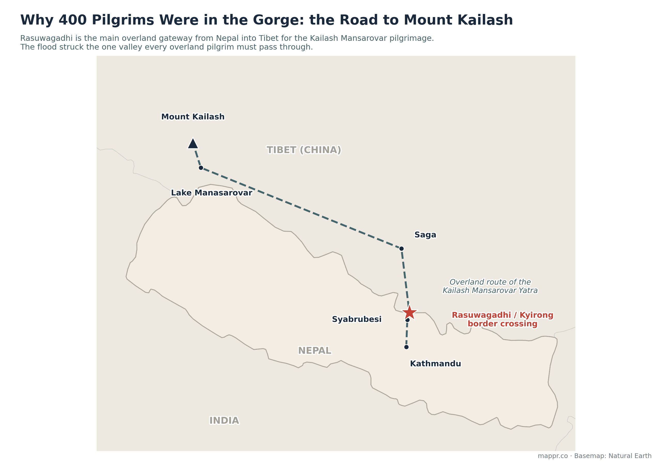
The scale of the missing list comes down to geography. Mount Kailash, sacred to Hindus, Buddhists, Jains and Bon practitioners, stands in far-western Tibet, and since China reopened the route, the Rasuwagadhi-Kyirong crossing has been the main overland gateway for the Kailash Mansarovar Yatra. Every overland pilgrim coming through Nepal funnels up this one valley. Late August is peak season.
By the morning of 29 August the disaster authority put the missing at 2,426 on the Nepali side, up from 1,924 the night before. Add the 554 missing in Tibet and the combined list is close to 3,000.
By Saturday afternoon police had trimmed that to 2,362: 1,863 Nepalis, of whom 1,591 are men and 264 women, and 499 foreign nationals, 223 men and 300 women.
That is the first time the list has moved down. It shrinks whenever someone is found alive, which is why it will keep swinging in both directions for days.
It went back up on Sunday. The disaster authority’s 9am bulletin on 30 August listed 2,498 missing, 589 of them foreign nationals, with 933 tied to hydropower sites and 85 security personnel.
By the 1pm count it had edged up again to 2,502.
Then it nearly doubled. The disaster authority’s 9am bulletin on 31 August put the missing at 4,247, up from 2,502 the previous afternoon, with 592 foreign nationals among them.
That is a registration effect rather than a second disaster. Families have kept arriving at district centres to file missing reports, days after the water passed.
By district on 31 August, Nuwakot accounts for 1,558 of the missing, Rasuwa 865 and Makawanpur 65.
Nuwakot’s figure rose from 115 to 1,558 in a single day, overtaking Rasuwa. The hydropower tunnels and the worst-hit downstream settlements are both in that district.
Then it turned. By Monday evening the disaster authority had the Nepali missing list back down to 3,925, after a midday peak of 4,347, with 3,333 Nepalis and 592 foreign nationals on it.
Nuwakot came down with it, from 1,558 to 1,158, while Rasuwa held at 865. The hydropower share fell furthest, from 933 to 639, as workers were traced or recovered.
It kept easing on Tuesday. The disaster authority’s 9am bulletin on 1 September put the Nepali missing at 3,916, with 583 of them foreign nationals and the hydropower share still at 639.
Rasuwa is unchanged at 865, which is now the single largest district figure on the list.
Then it jumped again. Nepal Police’s 5am bulletin on 2 September put the missing at 4,858, up from about 4,606 the evening before and well above the authority’s 3,916.
The authority then moved up to meet it. Its noon bulletin on 3 September listed 4,216 missing, above the 3,916 it had carried for two days but still short of the police figure.
Names are still coming off it one by one. Twenty-three workers from Bardiya who had been out of contact since the flood were reunited with their families, reported on 2 September after five days of silence.
On the previous evening’s breakdown, 933 of the missing were linked to hydroelectric project sites, 517 were foreign nationals and 127 were Nepalis living abroad who had come home to visit.
Another 161 names came through the Rasuwa emergency operations centre and 66 from Makwanpur. State employees account for 119: 45 army, 28 police, 13 armed police, 15 customs, 15 immigration and three Langtang National Park staff.
That count has since been redrawn. The disaster authority’s list on 2 September puts 147 local representatives, government staff, teachers and security personnel among the missing.
Security personnel are 83 of them: 45 from the Nepali Army, 25 from Nepal Police and 13 from the Armed Police Force. The rest are eight elected local representatives, 32 local government employees including 11 teachers, and 24 other government staff.
The Indian count has moved in both directions. India’s foreign ministry listed 288 nationals as uncontactable on 27 August, then revised it to 255 on 28 August with 84 rescued.
Its breakdown is a snapshot of who uses this road: 40 workers still missing from the Trishuli-1 power project (63 rescued), 86 Mansarovar pilgrims from Tamil Nadu, 61 travelling with one tour operator, 33 from Kerala and 32 stranded at Timure.
The American count has since moved the other way. Twenty-seven members of the US Congress, writing to Secretary of State Marco Rubio on 4 September, put at least 75 US citizens among the roughly 4,000 then missing, against the 90 counted earlier in the week.
Their letter asks Washington for five things: daily updates to families and to Congress, a Disaster Assistance Response Team on the ground, high-altitude and thermal drone assets, coordination with Nepali and Chinese teams, and faster reconstruction money.
US assistance so far runs to $3.6 million announced on 29 August, plus $500,000 through Catholic Relief Services for emergency shelter, water and sanitation.
Australia’s count came down to 42 on 1 September after one of its nationals was located on the Tibetan side, and Nepal’s tourism board had earlier counted 53 Ukrainians, 51 Malaysians and 33 Britons.
South Korea’s missing all come from one worksite. Nine Koreans went missing on 26 August, six employees of Doosan Enerbility and three of Korea South-East Power, working on a hydropower project in Rasuwa.
Foreign Minister Cho Hyun arrived in Kathmandu on 5 September for a three-day visit. He is due to meet Foreign Minister Shisir Khanal, the families of the missing Koreans, and the Korea Disaster Relief Team working with helicopters, drones, search dogs and thermal imaging.
Global Affairs Canada has raised its own count to 30 Canadians and permanent residents.
Roughly 100 Chinese nationals are also missing on the Nepali side of the border.
The foreign list has stopped growing. It stood at 583 on the 1 September bulletin, down from 592 the day before, and Nepal’s tourism department has now published the names.
That published list puts them at 38 countries, wider than the 33 the foreign ministry counted earlier in the week.
Most were moving in organised convoys between Kathmandu and the border. The counts still diverge badly: on 29 August alone, agency and wire figures for the dead ran from 633 to 673, with Nepal Police logging 669 bodies at 4pm.
Different agencies are counting different things at different hours, which is why the totals will keep moving for days.
The same gap opened on 30 August. The disaster authority logged 734 bodies at 9am and 788 by mid-afternoon, Nepal Police logged 768 at 2pm, and Al Jazeera was still carrying 781 that evening.
It shows in the rescue numbers too: the authority counts 279 people evacuated from hydropower tunnels, against the 350 AFP reports the army pulling out alive.
The gap widened again on 31 August. The disaster authority’s 9am bulletin listed 903 dead and 4,247 missing, while Reuters copy that morning still carried 788 dead and about 2,500 missing.
By Monday evening the two had converged. Reuters was reporting the authority’s own figures of 939 dead and 3,925 missing, a combined 955 and 4,471 once Tibet is added.
They came apart again on Tuesday. The disaster authority’s evening situation report carried 1,050 dead and 3,916 missing, while Nepal Police issued a 5pm count of 1,066 dead and about 4,606 missing.
Al Jazeera, working from an earlier authority update the same day, had Nepal’s dead at 1,003 and the combined figure with Tibet at 1,019. All three were published within hours of each other.
The gap carried into Wednesday. Police had 1,127 dead and 4,858 missing at 5am on 2 September, while the disaster authority’s chief executive was still citing 3,916 missing in coverage published that day.
The authority’s own Wednesday figure for the dead was 1,114, thirteen below the police count. That is the number Reuters carried in its copy a week after the flood, and the number most wires ran with.
“Out of contact” is not a casualty count: communications, roads and the border post itself are gone, and many of the missing are likely safe but unreachable on either side of the border. But with the gorge road severed in multiple places and helicopters struggling to land, establishing who is where will take days.
That is already showing in the numbers. The disaster authority now counts 11,814 people rescued by 1 September, up from 10,451 the morning before.
At least 16 helicopters are still flying the search, on top of the 411 flights logged by Monday.
Friday alone accounted for 517 people lifted out by air, across 99 helicopter flights using 16 aircraft.
The disaster authority counted 279 injured on 1 September, 111 of them still receiving treatment, out of 2,740 people given medical care. Every name confirmed alive comes off the missing list, which is part of why that list moves in both directions.
Police put the wider injury figure far higher: 2,301 people hurt and evacuated since Wednesday, 1,506 men and 795 women. The two counts measure different things, those currently in hospital against everyone carried out injured.
Around 1,000 displaced residents are now sheltering in nine holding centres in Nuwakot.
Illness is moving into the shelters
The camps have their own problem now. Health workers report viral fever at Pipaltar near Devighat, and displaced people at a school shelter in Laharepauwa, Rasuwa, have developed diarrhoea, with samples sent for testing.
Doctors at Trishuli Hospital and Kathmandu’s Sukraraj infectious disease hospital warn of cholera, respiratory infections and measles spreading in crowded shelters, alongside the psychological toll on people who lost families in a morning.
On 4 September that stopped being hypothetical. Five of 15 drinking water samples taken in Bidur Municipality in Nuwakot tested positive for E. coli, a marker of faecal contamination, and the sources have been chlorinated.
Bidur is holding about 2,700 displaced people in 25 centres and is trucking drinking water in by tanker. Diarrhoeal infections and fever are already appearing in the camps, without a major outbreak so far.
Health officials are preparing for one anyway: cholera vaccine for 100,000 vulnerable people if an outbreak takes hold, measles and rubella vaccine for 75,000 children under 15, and tetanus and diphtheria shots for displaced children.
On 6 September the first doses arrived. A Nepali Army helicopter flew 21,000 doses of cholera vaccine into Rasuwa on Sunday morning, obtained with support from the World Health Organization.
The campaign scaled up on 8 September. The Ministry of Health and Food Hygiene sent 80,523 doses of cholera vaccine to Nuwakot, 23 boxes with 10 freeze-free carriers, 220 ice packs and eight fridge tags.
Rasuwa’s vaccination starts on Thursday, its doses already flown in by helicopter. The ministry calls it a priority measure where damage to drinking water and sanitation has raised the risk of waterborne disease.
Health and Food Safety Minister Nisha Mehta had ordered medicines, vaccines and public health services pushed into the disaster districts, with disease surveillance stepped up and safe drinking water and sanitation given priority.
The injured are clearing the wards. Of 50 flood victims brought to Kathmandu’s National Trauma Centre, 38 had been discharged by 6 September, with 12 still admitted and most reported stable.
Nepal Police has set up citizen help desks at Bir Hospital and the National Trauma Centre, where relatives come to ask after the injured and to file details of people still missing.
Treatment got cheaper on 8 September. The Health Insurance Board removed co-payments and the cap on covered treatment for three months in Rasuwa, Nuwakot and Dhading, the districts the cabinet has declared disaster crisis zones.
Nobody has to produce a card. Insured people can be treated once their insurance number is verified through the system health facilities already use, which matters in wards where documents went with the houses.
How wide the damage runs
The government put a national number on it for the first time on 1 September. Its preliminary situation report counts nearly 1.6 million people affected, with Rasuwa and Nuwakot worst hit and Dhading, Gorkha and Chitwan moderately so.
The missing are not a local list either. Those 3,916 names have been reported from 62 districts across the country, because the people in the gorge that morning had come from all over Nepal.
One province has published its own share. Lumbini’s emergency operations centre counted 248 of its residents missing on 9 September, led by Bardiya with 76, Dang 54, Rolpa 24 and Banke 23.
Lumbini sits hundreds of kilometres southwest of the gorge and was never flooded. Its people were on the road as pilgrims, drivers and hydropower workers, which is how a Rasuwa flood empties households in the Tarai.
The report breaks them down by who they were: 62 percent Nepalis travelling in groups, 17 percent government employees and 15 percent foreign nationals.
It counts 11,814 people brought to safety, 253 of them foreign nationals, and 21,011 security personnel deployed: 8,896 from the army, 7,912 police and 4,203 armed police.
UN Women has put a figure on one slice of the need. It counts 43,000 women and girls requiring urgent assistance, out of 157,050 directly or indirectly affected in Rasuwa and Nuwakot alone.
Its assessment names pregnant and lactating women and people with disabilities as most at risk, puts food and safe water first, and warns of gender-based violence and trafficking. It has asked for $2 million.
The UN Development Programme has now measured the wreckage itself. Its preliminary assessment on 2 September puts the debris at 2.2 million tonnes, of which 556,200 tonnes comes from 2,359 damaged structures.
That assessment counts 84,270 people affected across 17 municipalities in six districts, a narrower measure than the government’s 1.6 million, and notes that about three quarters of them were already living in vulnerable areas with limited access to basic services.
It also puts numbers on the power loss: 11 hydropower stations and one solar plant, 431.1 megawatts between them, are off the grid, with 15 projects under construction and 470 megawatts of planned capacity damaged.
UNDP resident representative Kyoko Yokosuka framed the next stage: the scale of destruction is immense, and recovery has to reach the people hit hardest.
Nepal’s own accounting arrived on 4 September. The disaster authority put preliminary losses at Rs 387.54 billion, its first official figure, with executive director Dharma Raj Upreti cautioning that a detailed assessment is still to come.
The immediate bill is smaller and more urgent. Upreti says about Rs 8 billion is needed over the next four months to restore buildings, communications, energy and transport, health, nutrition, education, agriculture and livestock.
The formal accounting now has a deadline. On 5 September the government formed a panel under National Planning Commission vice-chair Gunakhar Bhatta to run the post-disaster needs assessment, with six weeks to report.
Seven clusters will work through infrastructure, health and education, climate, production, agriculture and the wider economy. The working estimate is about Rs 400 billion in loss and damage, which Bhatta expects to move by 20 to 30 percent either way.
The report is meant to feed a donor conference for reconstruction money. Its underlying counts are the familiar ones: 84,270 people affected across 17 municipalities in six districts, 7,570 houses and 48 government offices damaged, 55 kilometres of road, 37 motorable and 68 suspension bridges, and 1,806 hectares of land.
The assessment landed on 15 September. The government’s rapid damage and needs assessment puts total damage and economic losses at Rs408 billion across five districts, close to the working estimate and well inside the margin Bhatta had allowed.
Rebuilding costs far more than the damage. The same document puts total reconstruction at Rs723.31 billion, with hydropower and solar alone needing Rs390.62 billion against Rs151 billion of damage.
Most of the loss is private. About Rs300 billion, more than two-thirds of the total, falls on private enterprises, housing, hydropower, schools, vehicles and communications, according to National Planning Commission joint secretary Arjun Bhandari.
Commercial businesses account for Rs146.19 billion and housing Rs63.88 billion, with telecommunications at Rs628.7 million and agriculture at Rs2.53 billion.
Nearly 4,800 businesses were damaged: 1,259 hotels and restaurants, 1,212 wholesale and retail firms, 866 educational institutions, 263 manufacturers and 190 financial and insurance offices.
The housing count now breaks down by district. Of the 7,570 homes damaged, 3,977 are in Nuwakot, 1,779 in Rasuwa and 1,451 in Dhading.
The energy toll is 13 hydropower projects and five solar plants, 759 megawatts between them, with eight of the hydropower schemes privately owned. On the land, 1,806 hectares were affected and more than 1,000 animals killed.
About 600 children are unaccounted for
One group inside the missing list has now been counted separately. Local education offices, municipalities and schools put 622 students unaccounted for across Rasuwa and Nuwakot on 6 September, along with 22 teachers and school staff.
The wider child figure was larger again. UNICEF estimated 17,000 children affected in early September, and the disaster authority counted 6,901 students at 19 schools across Rasuwa, Nuwakot and Dhading.
Both numbers have since grown. On 10 September UNICEF put about 22,100 children affected, across five districts now: Rasuwa, Nuwakot, Dhading, Gorkha and Tanahun.
The Education Ministry produced its own count the same day. It lists 9,400 students affected across 32 schools, 3,928 of them directly hit and 1,373 displaced, with 488 students unaccounted for and five confirmed dead.
That 488 sits below the 622 reported on 6 September. It is a verified figure replacing a provisional one, gathered as phone links came back, and not a sign that children have been found.
The staff losses are counted too: 24 teachers and school employees unaccounted for and one dead. Of 527 classrooms assessed, 268 are destroyed.
The government answered with money for schooling. Education Minister Sasmit Pokharel announced a Scholarship Bank under a Secured Future Scholarship Scheme, guaranteeing free education to Grade 12 for children orphaned or displaced by the flood.
Support is graded: residential care, full scholarships, partial assistance or materials, with children who lost guardians taking priority. The private sector has pledged Rs 1 billion, about $6.62 million, for 1,000 students.
The figures come from local education units, municipalities and the schools themselves, and they are provisional. Verification is slow because phone links in the worst-hit wards are still unreliable.
The schools themselves took heavy losses. Twelve were destroyed outright, four in Rasuwa and eight in Nuwakot, six of those in Bidur Municipality and two in Tarakeshwar Rural Municipality.
More than 7,000 students are affected in all, and five local units have suspended classes. Several of the buildings still standing are being used as emergency shelters, which pushes the restart further out.
Most of them go back on Wednesday 9 September. Bidur Municipality in Nuwakot will reopen 65 of its 79 schools, 14 days after the flood, with deputy mayor Prabha Bogati saying children from flood-hit areas can attend whichever school is most convenient.
Fourteen will not reopen. Five schools in Bidur were destroyed outright, among them Tribhuvan Trishuli Secondary School and Chandeshwori Secondary School, nine more were damaged, and nine buildings are still serving as displacement centres.
The same municipal decision covers housing. Bidur announced house-rent assistance for flood-affected families alongside the restart of classes, for households that cannot go back to their own homes.
The Education Ministry widened the count on 18 September. It now puts 14,500 children out of school across 63 educational institutions in Rasuwa, Nuwakot and Dhading, with 9,430 directly affected and 1,372 displaced.
The damage behind that: 34 institutions hit, 45 buildings holding 268 classrooms destroyed, 11 schools closed outright and four more closed for now. Nearly 500 enrolled students are still unaccounted for.
The staff losses have grown as well, to 24 teachers and school employees missing and two dead, with at least 100 children orphaned by the flood.
Shelters are still holding the classrooms. 28 of the 29 holding centres in the three districts sit in school buildings, 22 in Nuwakot and six in Rasuwa, housing about 2,000 people.
Thirteen temporary learning centres are running against 68 planned, each built for about 30 students.
Some settlements may not be rebuilt where they stood
The housing loss now has a number. 8,317 houses were destroyed, and 3,948 people are living in holding centres, with around 15 settlements across Rasuwa, Nuwakot and Dhading affected.
The government is mapping which of them are no longer habitable. It is weighing acquiring government land in safer places, either vacant ground inside the same districts or, for some settlements, sites in other districts entirely.
The National Planning Commission is drawing up a master plan for the rebuild, with the Ministry of Infrastructure Development taking roads and bridges first.
A survey to decide who gets a roof
The temporary-housing question now has a process. The Department of Urban Development and Building Construction began a needs survey on Tuesday 8 September, working from a form built in the KOBO Toolbox.
It records how badly each house was damaged, whether the family lost anyone, whether they want government shelter or rent support, whether they have land left, and what water and sanitation they can reach.
Families in holding centres come first, with about a week set for that round, and families sheltering elsewhere are assessed after. The Prime Minister’s Secretariat announced it on 10 September.
The children left without parents
The National Child Rights Council has counted the children in the shelters. It lists 1,233 in 30 holding centres, 632 girls and 601 boys, with 21 of them living with disabilities.
Of those, 692 still have one or both parents with them. 439 are separated from their families, and 102 have lost both parents.
That gap in the records is itself the danger. NHRC member Lily Thapa said authorities still lack full data on the children who lost both parents, which leaves them open to trafficking and sexual abuse.
A protection action plan costed at about Rs 740 million divides the duties across agencies, with a temporary centre for parentless children planned at Thecho in Lalitpur.
The people who have done this before are cautious. Former prime minister Baburam Bhattarai and former National Reconstruction Authority chief executive Gyewali both argue that moving people hundreds of kilometres from their traditional homes is not practical, and former home secretary Pokharel says the displaced should have a say in where they go.
There is a precedent behind that caution. After the 1993 floods a resettlement was built for displaced families along the Bagmati in Sarlahi, and most residents eventually drifted back to their original homes because their land and their social networks were still there.
Trapped in the hydropower tunnels
The single largest block of the missing is underground. The power producers’ association IPPAN counts 934 workers unaccounted for across 11 hydropower projects, and the Nepali Army has prioritised 19 tunnels.
At Upper Trishuli-3B, 191 are still unaccounted for on 4 September. Three small excavators are digging there and have not yet located the project building, because landslides are blocking the road a large excavator would need.
Deputy director Leela Aryal says a big machine may have to be taken apart and rebuilt on site. Teams are also trying to open a passage from the Audit-2 side, and army crews have cleared 426 metres there.
Rasuwagadhi still has 93 missing: 51 employees, a board member, two daily-wage workers and 39 contractor staff. A generator, pump and hoses were airlifted to Dhunche on Friday morning, and bad weather held them there.
At Upper Trishuli-1, 254 people have been brought out. At Upper Trishuli-3, whose construction site is buried under flood debris, 85 of 213 reported missing had been rescued as of 29 August, a figure later overtaken by the army’s own tally.
Around 100 workers are still thought to be trapped at Upper Trishuli-3A, where the cable tunnel entrance is buried and crews are digging it out. Locating the entrances at all has been part of the problem.
On Saturday 29 August that dig broke through. Rescuers reached the Trishuli-3A tunnel and began pumping air inside, after the operation’s first controlled blast opened part of the buried entrance and two excavators hauled out the debris.
A joint force of 82, made up of 62 Nepali Army personnel and 20 from the police and armed police, has worked the site since Friday night. AFP reports the army has now brought 350 people out of the flooded tunnels alive.
By Sunday morning the crews had a pipe and a camera inside. Air is being pumped through the opening, food is going in through the bored holes, and excavation is under way to get a rescue team into the mud-swamped passage.
Home Minister Sudan Gurung said the next step is to widen the hole and send people in. Officials believe more than 100 workers may still be alive inside the Trishuli-3A and 3B tunnels.
On Sunday afternoon the army found the crown, the uppermost section, of the Upper Trishuli-3A tunnel and drilled a hole into it.
Nobody answered. Army spokesperson Rajaram Basnet said the water runs high inside a tunnel roughly seven metres across, and rescuers calling in through the opening got no reply. Thermal drones have picked up no signs of life.
How many people are down there is itself disputed. The army says at least 35, Nepal Police puts it at around 200 after a technical assessment, and the gap matters because it sets the scale of everything that follows.
The plan now is bigger equipment, more blasting and a wider opening. By 3pm on Sunday the Nepali Army had brought 409 people out of the flood zone.
Crews worked through the night into 31 August, using earth movers to pull mud and rock off the Trishuli-3A and 3B tunnel entrances. Progress is slow, and one of the entrances turned out to be full of water.
Arnold Dix, the Australian tunnel engineer advising the operation, put it plainly: rescuers are looking for another way in, and they are working round the clock.
Chinese and Indian tunnel specialists are now working alongside the Nepali Army, after Nepal asked both governments for the help it had turned down earlier in the week.
The hydropower count has eased a little. The Nepal Electricity Authority and IPPAN now list 897 people linked to the projects as unaccounted for, with 361 workers rescued. Chinese and Indian tunnel teams arrived on Saturday, the Chinese with thermal cameras, drilling gear and air pumps, the Indian with DNA collection experts.
By Monday evening the disaster authority had the hydropower missing down to 639, from 933 that morning.
The first bodies came out of the tunnels the same day. Three were recovered from two sites: one at Upper Trishuli 3A, where a Chinese team pushed about 300 metres in, and two at Chilime, where mud blocks the passage further inside.
An Indian team got roughly 100 metres into the Upper Trishuli-1 tunnel before hitting a blockage. Rescuers who went down on ropes and called out have still had no answer from anyone inside.
There was better news at Trishuli-III. The army brought 208 people out of that tunnel alive on 29 August, 43 of them foreign nationals, including 38 Chinese and five Indians.
At Chilime, six of the eight missing are believed to be inside a tunnel packed with mud that nobody can enter. At Rasuwagadhi, 49 employees are missing, three to six of them possibly inside the underground powerhouse.
At Langtang Khola, 18 have been rescued and 40 to 45 are unaccounted for, with the bridges to the site swept away. Everything there now moves by helicopter.
By Tuesday 1 September the shape of the underground search had firmed up. About 900 workers are unaccounted for across 12 damaged hydropower projects in Rasuwa and Nuwakot, and roughly 500 of them are thought to be inside tunnels.
Four bodies have now been brought out of three mud-filled tunnels, one more than the day before.
Upper Trishuli-1 carries the largest single number: 576 people missing, of whom about 300 are believed to be inside. At Upper Trishuli-3B, 122 are unaccounted for and excavation near the tunnel began on Monday.
At Upper Trishuli-3A, 30 to 40 people are thought to be in the underground powerhouse, with roughly 120 metres of water and mud still between them and the rescuers. The debris over the site stands 16 to 17 metres high across a width of 30 to 40 metres.
Energy expert Shriram Neupane described the obstacle plainly: water and mud at the crown, large rocks in the way, and crews breaking them day and night.
At Rasuwagadhi, where more than 90 people are now listed missing, rescuers got into the tunnel and found it completely blocked seven metres short of the powerhouse entrance. At Chilime the tunnel is full of water with the tailrace blocked, so it has to be pumped out before anyone can advance.
About 10,000 Nepali troops are now on the tunnel operation alongside the Chinese and Indian specialists. Arnold Dix’s case for keeping at it is simple: an intact powerhouse would give anyone inside air and water.
By Tuesday the progress had a measure in metres. Search crews were about 200 metres into the Upper Trishuli-1 tunnel, around 150 metres into Langtang and about 50 metres into Chilime, where foreign rescuers are working with the army.
At Upper Trishuli-3A the entrance has been located, water is being drained and air pumped in, with excavators and rock breakers clearing the approach. Teams are still trying to get into 3B.
Across the hydropower sites 279 people have been brought out alive, 221 of them at Upper Trishuli-3A in the hours after the flood and 33 at Upper Trishuli-1.
By Wednesday the ledger had been redrawn. The projects now list 947 people unaccounted for across the damaged schemes in Rasuwa and Nuwakot, a firmer figure than the round 900 used earlier in the week.
Upper Trishuli-1 carries 557 of them against 254 rescued. Upper Trishuli-3B has 191 unaccounted for, Rasuwagadhi 93, Langtang Khola 41 feared trapped and Chilime eight.
At Upper Trishuli-3A the estimate has narrowed to 42 believed to be inside the powerhouse. A joint team is drilling through the outlet tunnel and has not reached them.
The other fronts each have their own obstacle. The Rasuwagadhi passage is completely blocked short of the powerhouse, Chilime is still waiting on essential equipment, and a technical team only joins the Langtang Khola operation on 3 September.
A search-and-sniffer dog team went in to Upper Trishuli-1 on 2 September. Nepali, Indian, Chinese and South Korean teams are now working the sites together.
Langtang gave up its first bodies on 3 September. Two were recovered from the Langtang Khola project tunnel, the first recoveries at that site.
The way in was improvised. A team of seven or eight, including a hydro-mechanical engineer from the project company, went through the empty penstock pipe to reach about 150 metres inside, after the government team’s main route stalled at 100 metres.
Upper Trishuli-3A is measured in cubic metres. Two excavators working since 29 August have pulled about 20,000 cubic metres of mud, rock, concrete slabs, beams and pillars off the entrance to the 160-metre cable duct.
That has cleared roughly 50 metres of the portal, down to about 2.5 metres below the tunnel crown. Engineer Udayaraj Neupane says roughly three metres of debris still have to come out before an access and drainage passage opens.
The site has no road. Machinery and repair parts go in by helicopter, which is part of why the work has taken as long as it has.
The Wednesday state of each front comes with team sizes. A 93-strong crew is clearing debris and blasting at Upper Trishuli-3A, where the outlet has been found under about 1.5 metres of floodwater that has to be pumped out first.
A 61-strong army team is cutting an access road at Upper Trishuli-3B. A joint team of 25, foreign rescuers among them, is 150 metres into Langtang, and at Rasuwagadhi crews got about 150 metres in before large rocks stopped them.
More than 9,200 Nepali Army personnel are deployed across Rasuwa, Nuwakot, Dhading, Chitwan and Nawalparasi East, on search, body recovery, road clearance and medical work.
Home Minister Sudan Gurung is still framing it as a rescue: they have not lost hope yet, and there is a chance the workers are alive on the water inside.
Not everyone in the operation says the same thing. A week on, Phanindra Paudel of Nepal’s National Emergency Operation Center said the hope of finding survivors is decreasing, while adding that they still pray and still hope.
Arnold Dix put the other side of it on 3 September. Advising remotely on Trishuli-3A, the Australian tunnel expert said the operation is still a rescue and not a recovery, because a tunnel is sheltered and comparatively stable in temperature.
His argument rests on what silence does and does not mean. In his words, silence is not evidence of death, it is only the absence of a signal.
He pointed to three precedents: the 33 Chilean miners brought out after 69 days underground in 2010, the 12 boys and their coach rescued from Tham Luang cave after nine days in 2018, and the 41 workers freed from the Silkyara tunnel in India after 17 days in 2023.
The case for the tunnels is narrower than the case for the valley. Amshu Kiran Shahi, a Nepal Electricity Authority board member, says they are confident there is life inside because there is food in the powerhouse buildings.
American specialists have now joined the Indian and Chinese teams working the tunnels. Nepal Telecom and Ncell both say nearly all their damaged sites in the flood zone are back in service.
Having a signal is not the same as having a line. Residents in Rasuwa, Nuwakot and Dhading say calls take several attempts to connect, drop midway, or come through so distorted that neither side can make out the other.
The developers’ own engineers came late. Managing director Giriraj Adhikari said the technical team should have been on the ground from the outset, and joint coordination only began on 1 September.
Two men come out of Trishuli-3A alive
Then, on Friday morning, the tunnels gave something back. Sanjay Sah, a 30-year-old mechanical foreman, and Kabir Maharjan, a 45-year-old mechanical supervisor, were brought out of the Upper Trishuli-3A tunnel alive, nine days after the flood.
They were not in the powerhouse. Project chief Awas Ojha says both were found along the route leading to it, and that the rescue team has still not reached the powerhouse itself.
The darkness inside made it impossible to measure how far short of it they were. Ojha says the exact number of people still underground remains unclear, while Sah told rescuers that everyone inside was safe.
The Nepal Electricity Authority still puts about 42 engineers and staff inside the powerhouse, a 60-megawatt plant that had been shut down for a complete overhaul, with the water tunnel closed, when the flood arrived.
Both men were airlifted to Kathmandu, Sah to Birendra Army Hospital in Chhauni and Maharjan to the National Trauma Centre. Their condition was reported as normal at the site.
Lawmaker Shri Ram Neupane described the moment rescuers made contact. The team called out that nobody should panic and that they were there to rescue, and a voice from inside answered back.
Home Minister Sudan Gurung called it a ray of hope after ten days. Maharjan had worked at the project for seven years, and his wife had last heard from him at about 7:30am on the morning of the flood.
Their own account came out on 8 September. The two had sheltered in an air pocket in the cable-duct tunnel, about 160 metres from the exit, in complete darkness, Maharjan drinking muddy water and Sah reciting prayers to hold his nerve.
The breakthrough came at about 7am on 4 September. A team under engineer Sagar Dhakal and lawmaker Shri Ram Neupane heard the answer from inside, hunuhuncha, we are here. Neither man could walk out, and Maharjan needed surgery on a deep infected wound to his leg.
Then the tunnel went quiet again
The hope lasted hours. A seven-member Armed Police Force collapsed-structure team went in after the rescue, crawled for 15 to 20 minutes and says it reached every section of the tunnel, including the farthest point.
They found one body and nobody else alive. In the words of team member Ambar Mahat, they did not hear any other voices.
What they crawled through was mud, soil and rock, with tunnel slabs collapsed by water pressure. The station chief has asked for the search there to be halted while staff work out which locations are still worth checking.
That leaves a contradiction on the record. The Nepal Electricity Authority had put about 42 engineers and staff inside the Trishuli-3A powerhouse, and the search team says it has now been everywhere it can reach.
A third survivor, and a woman found at Betrawati
Then Saturday gave two more. At about 1:20pm on 5 September, ten days after the flood, a Chinese worker was brought alive out of Audit Tunnel 4 at the 216-megawatt Upper Trishuli-1 project by the Nepali Army and a Korean disaster response team.
He was given first aid at the site and taken to the army’s Maithil Barracks at Trishuli in Nuwakot. The Reuters report described him as exhausted and disoriented, his skin and clothes caked in dried mud.
It is the first person recovered alive from Upper Trishuli-1, the project that carries the largest single missing count of the disaster. Search teams say more workers may still be trapped in its other tunnels.
The other rescue was nowhere near a tunnel. Chandrika Shrestha, 64, was pulled out of her own house at Betrawati, in ward 1 of Bidur Municipality in Nuwakot, ten days after the water came through.
A police squad under Inspector Mahendra Darnal heard a faint cry for help from inside the four-storey building, whose lower floors were packed with sludge. They broke a window, cleared the mud and brought her out.
She was airlifted by army helicopter to Birendra Military Hospital in Kathmandu and reported out of danger. Deputy Superintendent Iqbal Hawari said the team found her while clearing the area.
Where each tunnel stands
A project-by-project review published on 5 September puts 942 people unaccounted for across 11 damaged hydropower projects and one solar plant, with Nepali, Chinese, South Korean and Indian teams spread across the sites.
By Tuesday 8 September the projects’ tally had eased to 919 across the 11 schemes in Rasuwa and Nuwakot, a fall of 23 in three days as the lists are reconciled.
That number was never a count of people underground. At a disaster authority press conference on 7 September, Brigadier General Subash Jung Thapa said the army’s assessment shows about 121 people entered the tunnels.
Thapa put it plainly: the army has evidence that only 121 people went in. The roughly 900 on the project ledgers counted staff attached to the schemes, in camps, offices and quarters, not people inside the tunnel network.
It is a correction, not relief. Thapa said workers caught outside the tunnels remain unaccounted for, so the projects’ eventual toll may run well above 121, and the army’s damage assessment puts the water and debris at roughly 180 kilometres per hour.
Two of those sites were called finished. The Trishuli-3A search was stood down after the crawl through found nobody else alive, and the Langtang Khola teams withdrew once they had covered everything they could reach, with two bodies recovered and the powerhouse swept away.
Trishuli-3A is back on the roster. The log for Tuesday 8 September puts 34 army personnel, four armed police and project staff searching its powerhouse and tunnel again.
Upper Trishuli-1 still carries the largest count, 557 missing, of whom about 115 are thought to be in the tunnel and dam area. A South Korean team is working there with drones and trained dogs, and 15 rescue machines have been brought in.
The other fronts are slower. Chilime has six missing behind about 90 metres of mud and water in the main access tunnel, Rasuwagadhi’s 93 sit behind a route to the underground powerhouse still blocked by mud and rock, and Upper Trishuli-3B’s 191 are being dug for with three small excavators.
Tuesday moved all three on. A joint team with foreign technicians is about 400 metres into the main access tunnel at Upper Trishuli-1 and about 115 metres into Chilime, where a rock blocking the approach road was blasted out to open the route.
Ninety-five metres of Chilime’s tunnel remain before the next major obstruction. Four six-metre pipes have been driven in to hold the passage open, with winches and buckets hauling the debris out.
At Upper Trishuli-3B, 101 soldiers with three excavators have dug about 23 feet down around the offices and quarters and found nobody in the excavated ground. A drone search of the Ronga cable tunnel at Rasuwa Bhotekoshi located one body.
Chilime became an active site again on 6 September. A team under chief executive Babu Raja Maharjan went in after reports that six people were trapped inside the 22 MW project’s tunnel, with Rastriya Swatantra Party lawmaker Shri Ram Neupane travelling to the site.
Upper Trishuli-1 gave up two more that day. Two unidentified bodies were recovered from inside the tunnel complex during deep searches, the first recoveries there since the Saturday rescue.
The man who came out alive has a name. Lu Haitao, 49, from Henan province, was found about 225 metres inside the tunnel after 11 days and is being treated at the military hospital in Chhauni.
He told Chinese embassy staff he had heard the searchers’ whistles and dismissed them as his mind playing tricks. He could not hear their shouts in the dark, and only believed it when they shone a light in his eyes.
The kit is still arriving. Switzerland handed the Nepal Electricity Authority a caged Flyability drone built to fly in dark, narrow tunnels and survive collisions, and an 11-member Malaysian SMART team has joined with nine high-capacity drones.
Nepal has asked for more. The foreign ministry has formally requested LiDAR, ground-penetrating radar, high-accuracy laser meters, mobile air traffic control systems, high-capacity surge pumps, inflatable walkways and advanced DNA kits from the international community.
The rest of the ledger is short: seven missing at Mailung Khola, four at Rasuwa Bhotekoshi, three swept away at Trishuli, two at Madhya Trishuli Ganga and one at Devighat. The Nuwakot solar plant lost no staff.
The picture changed at Rasuwagadhi on 7 September. The Ministry of Energy, Water Resources and Irrigation said rescue teams had reached the Rasuwagadhi powerhouse, the route that had been blocked short of it, with mud pumps and generators airlifted to the sites.
Chilime drew the outside expertise. Arnold Dix, the tunnelling engineer who advised the 2023 Silkyara rescue in India, arrived in Nepal on 5 September and is working the Chilime tunnel with Nepali and Indian teams under Colonel Parikshit Mehra of the Indian Army and the National Disaster Response Force.
Dix called the operation unlike anything he had handled: not one rescue but several possible ones at once, in different places, each with its own dangers. He also said Silkyara had taught him never to confuse unlikely with impossible.
On 10 September he went further. Dix said disasters of this kind are very rare and that this may be the first such incident anywhere in the world, which is also why the rescue has no template to follow.
He pushed back on the criticism of the hydropower projects. Based on what was known until two weeks ago, he said, the designs there were appropriate, and nobody had seen an event like this before.
His recommendation is for the next plant, not this one: build rescue and safety systems into hydropower projects from the design stage, so an extraordinary event does not become an unreachable one.
Access is the slow part. Indian ambassador Naveen Srivastava said on 6 September that a rope link was being strung from Syabrubesi to the tunnel to move more people in, and that about 950 metres of temporary road had been cleared.
The army is not standing the operation down. Spokesman Raja Ram Basnet told AFP on 7 September that searches were continuing with the same tempo as day one, on the ground, by air and in the tunnels, and that the aim was to be sure nobody was still stranded.
The army repeated that in its own terms on Monday. Search and rescue will run until every tunnel has been broken through and searched, it said, unless the government orders the operation stopped.
Monday moved three of the sites. Teams reached the Rasuwagadhi powerhouse and control room, cleared the Audit-2 tunnel at Upper Trishuli-3B without finding anyone, and pressed on at Upper Trishuli-1 with thermal imaging cameras and foreign technicians.
At Chilime a joint team with foreign technicians is still pumping out mud, and an excavator flown in by helicopter is being worked up to the tunnel mouth over the improvised track from Syabrubesi.
Chilime gets a road on 9 September. The temporary track to the rescue site comes into operation on Wednesday, ending the helicopter-only access that had held until Tuesday, and a night shift starts so the work can run around the clock.
The distances are short and the going is slow. The team is about 90 metres into the main access tunnel with roughly 95 metres left before the main rock formation, and the powerhouse sits about 200 metres in. Six people are still thought to be inside.
The army has called in a man who knows the plant. Kulman Ghising, chair of the Ujyaalo Nepal Party, a former energy minister and once Chilime’s executive director, is at the site coordinating the rescue and giving technical guidance at the Nepali Army’s request.
The search has since been wound down. By 16 September the Nepal Electricity Authority had halted operations at 10 of the 13 damaged projects, leaving active work only at Chilime, Upper Trishuli-1 and Upper Trishuli-3B.
The stopped list includes the 111 MW Rasuwagadhi, the 120 MW Rasuwa Bhotekoshi, the 5 MW Mailung Khola, the 60 MW Upper Trishuli-3A, the 14.1 MW Devighat and the 14.3 MW Upper Mailung. Weeks of digging at those sites produced no survivors.
The three sites still working gave up 10 bodies on 16 September, five at Upper Trishuli-1 and five at Chilime, three weeks after the flood.
At Chilime the team cleared about 1,050 metres of debris to reach the tunnel mouth, then searched roughly 130 metres in before rising water stopped the excavation. Army spokesperson Rajaram Basnet said two bodies had been brought out and crews were still working to retrieve the third.
The Kathmandu Post counted three recoveries at Chilime that day against the wire tally of five. Read the gap as bulletin timing inside a single day, not a correction.
The project ledger has moved as well. The Independent Power Producers’ Association Nepal counts 868 workers unaccounted for across 11 projects, down from 919 on 8 September, with about 497 of Upper Trishuli-1’s 1,433 workers among them.
The energy sector has its own bill. Preliminary losses across hydropower, solar and transmission are put at Rs134.69 billion, with 410.06 megawatts knocked off the national grid and 783.39 megawatts of generating capacity damaged.
The project ledger moved again on 23 September. Energy Minister Biraj Bhakta Shrestha told a briefing that more than 800 people attached to the hydropower schemes are still unaccounted for, a month after the flood.
Upper Trishuli-1 carries the bulk of it, 439 of the 1,433 workers on its books, with 955 rescued or since contacted. Upper Trishuli-3B has 178 unaccounted for and Rasuwagadhi 93.
The rest runs shorter: Upper Trishuli-3A 39, Langtang Khola 39, Mailung Khola seven, Rasuwa Bhotekoshi three, Trishuli three and Madhya Trishuli Ganga two. A further 47 Nepal Electricity Authority employees are on the list.
The recoveries were counted too: 39 bodies from the Upper Trishuli-1 tunnel, one from Upper Trishuli-3A, two from Langtang Khola and five authority employees found dead at Chilime.
Shrestha said the government would keep searching for as long as there is a possibility of finding survivors, with troops, police, tunnel specialists and foreign teams still on the sites.
A corridor that keeps being rebuilt
The Bhote Koshi corridor is one of the most economically important, and most dangerous, valleys in Nepal. It carries the country’s main overland trade route to China, a cascade of hydropower plants, and the tourist traffic of Langtang and Kailash. It has now been wrecked three times in a decade: by the 2015 earthquake, the July 2025 outburst flood, and this one. Each time, the bridges and the border post have been rebuilt in the same narrow gorge, because there is nowhere else for them to go.
The damage bill so far
NDRRMA spokesperson Shanti Mahat put the infrastructure toll at 35 motorable bridges, 45 suspension bridges and around 40 kilometres of road damaged, with roads blocked across nine districts.
The 4 September bulletin puts it higher: 55 kilometres of road destroyed, 37 motorable bridges and 68 suspension bridges damaged, along with 48 government buildings, 18 schools and seven health facilities.
The bridge count moved again on 8 September. The Department of Roads says 41 motorable bridges were destroyed between Rasuwa and Chitwan and four more damaged, leaving 18 of the 63 bridges on that corridor intact.
It has also priced its own network. The department puts the damage to roads and bridges at about Rs30 billion, and the cost of rebuilding them at about Rs50 billion.
Seven Bailey bridges, 30 to 70 metres each, are needed between the Rasuwagadhi crossing and Syabrubesi. China has sent two 100-metre spans to the Korala crossing in Mustang, about 320 tonnes on 17 trucks with two Chinese technicians, and delivery is expected to take about a week.
India has offered Bailey bridges as well, and none had arrived by 8 September. Joint secretary Sushil Babu Dhakal put the harder problem simply: even where Bailey bridges are available, there is no road to carry them to the sites.
On the corridor itself, about 1.5 kilometres of track is still to be opened between Dhunge Bazar and Betrawati.
It also counts the land. 1,806 hectares of farmland were destroyed with an estimated 7,686 tonnes of lost food production, and three hydropower projects, a solar plant and two transmission lines were damaged.
On 7 September the authority set out what that means for food. Disaster authority spokesperson Shanti Mahar said the loss falls on standing paddy, both hybrid and indigenous, along with soybeans and pulses planted on the field bunds, in a season that was close to harvest.
The people who grew it are on the missing list too. Six farmers working on an indigenous crop promotion project are unaccounted for, and Nepal Agricultural Research Council monitoring head Sudha Sapkota says some survivors no longer have any farmland left to cultivate.
Nine hydropower projects and nine bank branches were destroyed. Nepal’s cabinet has declared the affected local units disaster crisis zones for three months under Section 32 of the Disaster Risk Reduction and Management Act, and ordered free treatment for the injured.
The power loss now has a number on it. The Nepal Electricity Authority says the damaged plants have taken about 431 megawatts off the national grid, with a further 470 megawatts of projects still under construction also hit.
Parliament has put its own panel on the bill. The House of Representatives Finance Committee formed a seven-member subcommittee on 9 September under MP Sushil Khadka to study the flood’s economic impact and the climate finance question.
It has nine days to report, with a deadline of 18 September. The other members are Narendra Kumar Kerung, Parashuram Tamang, Pushpa Raj Kandel, Lima Adhikari, Pushpa Chaudhary and Sushant Baidik.
The bill has now reached the growth forecast. The Asian Development Bank cut Nepal’s projection for 2026-27 to 4.1 percent on 23 September, from the 4.5 percent it published in July, and lifted its inflation forecast to 5.3 percent.
It blames the flood directly: damage to transport links, hydropower and productive assets, and the disruption that followed to trade, tourism, agriculture and local business.
The bank’s own damage lines put preliminary tourism losses at Rs52.67 billion, direct flood losses at Rs30 billion and hydropower restoration at about Rs400 billion, with more than 430 megawatts off the grid, roughly a tenth of installed capacity.
The World Bank followed on 6 October. Its Nepal Development Update, titled Building Back Differently for the Future, cuts growth for this fiscal year to 3.7 percent from the 4.2 percent it projected in April, against a government target of 6 percent.
It expects a rebound to 5.2 percent in 2027-28 once reconstruction spending lands, and inflation to stay inside the 5 percent target. It traces the hit through four channels: energy, transport, trade and tourism.
Its damage line sits below the government’s. The bank puts direct damage to physical assets at $1.66 billion, 83 percent of it infrastructure, 11 percent residential buildings and 6 percent non-residential, against the government’s $1.81 billion and $2.7 billion in total disaster effects.
Recovery and reconstruction needs come to $4.8 billion, almost all of it longer-term rather than immediate, with infrastructure taking 65.5 percent. It counts 430.7 megawatts of affected capacity, 10.6 percent of what Nepal has installed.
David Sislen, the bank’s division director, framed it as a moment to rebuild differently, with resilience and redundancy central to Nepal’s infrastructure planning.
The lights come back, unevenly
Distribution has recovered faster than generation. By 6 September the utility said power was back across more than 75 percent of the affected areas, with about 300 megawatts of generation still offline.
Acting executive director Dirghayu Kumar Shrestha put Rasuwa at 75 to 80 percent restored and Nuwakot at around 95 percent, with Dhunche at about 90 percent and Dhading back in full.
A day later the energy ministry sharpened those numbers: 99.8 percent of households in Dhading and 96.7 percent in Nuwakot had supply back on 7 September, with a Nepal Electricity Authority technical team still working on the rest of Rasuwa.
Where the grid will not reach soon, the answer is panels. Thirteen solar systems for offices and 500 household units have been flown in, and another 1,268 household systems are planned for Rasuwa.
The fix was improvised out of an old line. Engineers took the 66 kV route from Chilime and Devighat that once fed Kathmandu and stepped it down to 11 kV to charge local feeders.
The disaster authority’s household figures show where the gaps are. Nearly all of Dhading’s 83,642 households have power and 96.7 percent of Nuwakot’s 68,679, against 78 percent of Rasuwa’s 14,281.
Syabrubesi and Timure are still off the grid. More than 100 solar backup units have been sent there, and in Amachhodingmo Rural Municipality only ward 1 has electricity, with four wards dark.
Rasuwa moved again on 9 September. Energy Minister Biraj Bhakta Shrestha put restoration at 83 percent there, up from 78, and at 95 percent in Nuwakot, with wards 10 and 11 of Bidur Municipality and Tarkeshwar-4 reconnected.
A crossing is going back in alongside it. The Nepali Army is installing a 60-metre temporary steel bridge over the Tadi at Devighat in Bidur, replacing the permanent span the flood destroyed on 26 August, using its own technical team.
The Department of Roads says the whole 42-kilometre road from Betrawati in Nuwakot up to the Rasuwagadhi crossing has been destroyed at multiple points, including several concrete bridges.
Tatopani closes, leaving one road to China
Nepal lost its fallback crossing on 31 August. China closed the Tatopani border point, Zhangmu on its own side, to imports and exports, citing landslide risk at Liping on the Nepali side.
Nepal’s consul general in Lhasa, Laxmi Niraula, confirmed the suspension. Travel between the two countries is still allowed there, only trade has stopped.
That distinction mattered on 3 September. 114 Nepalis who had been stranded in China since the flood came back through Tatopani, out of 147 expected to cross.
Chinese authorities moved them from the Kerung area down to Liping and handed them to Nepali officials, with the Armed Police Force border outpost and the immigration office processing their entry. Three buses took them to Kathmandu for onward travel to Sindhupalchok, Nuwakot and Rasuwa.
The chief of the Tatopani immigration office confirmed the split: movement of travellers through the crossing remains open, while trade and customs operations stay suspended.
The flow has kept up since. The foreign ministry’s 8 September situation update puts 642 Nepali nationals returned from China through Tatopani, with another 94 expected to cross that day.
With Rasuwagadhi destroyed, that leaves Korala in Mustang as the only working overland trade route to China. Traders are warning of shortages and higher prices into the festival season, and officials say rebuilding customs at Rasuwagadhi will take months.
The cost at the crossing itself is becoming clearer. Between 70 and 75 loaded containers were swept away after clearing customs at Rasuwagadhi, and the customs chief puts more than 100 more in the yard, a figure traders reckon is above 200.
Another 170 containers are stranded at Kerung on the Chinese side waiting to be rerouted, 30 of them carrying fruit that will not survive the wait. Most of the load was ready-made garments and festival-season goods.
The rerouting is now under way and larger than that. More than 400 containers held in Kerung warehouses are being brought in through Korala instead, according to Musa Transport, the Shigatse-based haulier moving them.
Managing director Jiang Xeping says the detour is being pushed hard because Dashain and Tihar are close and rebuilding the infrastructure at Rasuwagadhi will take time.
The customs office had collected Rs900 million in revenue in the nine days before the flood. Ram Hari Karki, who chairs the traders’ association, says the losses run into billions of rupees with no way to fix a figure yet.
The human cost at the border sits apart from the pilgrim count. At least 15 customs employees are unaccounted for, along with more than 300 container drivers and workers, 234 of the missing coming from Sindhupalchok district and 73 from Bhotekoshi Rural Municipality alone.
Langtang Valley is cut off
The flood took the valley’s road out too. Langtang is severed from Dhunche, the Rasuwa district headquarters, after the bridges, roads and trails between Syabrubesi and Dhunche were destroyed.
What is left is a two-day walk via Thulo Syabrubesi, or a helicopter. Four of the five local units in Rasuwa were hit, and 67 residents of Naukunda Rural Municipality are still out of contact.
Langtang itself has 116 households and about 450 residents. Around 15 to 20 tourists were still waiting on helicopter evacuation, and the local health post says its medicines will last until Dashain.
Officials expect serious food shortages if the roads are not back within a month to six weeks. Sandu Chusang, a ward member in Langtang, says the government needs to start rebuilding the roads and bridges now.
The trekking season is the other casualty. The area drew about 25,000 domestic and foreign visitors a year before the flood, and 53,000 came to Langtang and Gosainkunda in the last fiscal year.
Cancellations spread beyond the flood zone
The bookings did not stop at Rasuwa. On 3 September the government launched a #NepalCalling campaign to separate the disaster area from the rest of the country, led by Tourism Minister Khadak Raj Paudel with Foreign Minister Shisir Khanal and the Nepal Tourism Board.
The timing is the problem. September to November accounts for nearly 40 percent of Nepal’s annual arrivals, and tourism is about 6.7 percent of GDP and more than a million jobs.
One Kathmandu hotel, the Dom Himalaya, saw 20 percent of its bookings cancelled within a week of the flood, with losses building as the rescue operation dominated the news.
The message is that most of the country is open. Khanal named Kathmandu, Pokhara, Chitwan, Lumbini, Janakpur, Bardiya and the Annapurna and Everest regions as operating normally.
Four routes are off. The Trekking Agencies’ Association of Nepal is warning against Langtang Valley, Gosainkunda, the Helambu Circuit and the Tamang Heritage Trail. As Paudel put it, tourism is an industry linked to emotions and based on empathy.
Two more closed on 6 September, well outside the flood zone. Gorkha’s district administration suspended trekking on the Manaslu Circuit and over Larke Pass after a flash flood at Chumnubri Rural Municipality-4 took an iron bridge and a suspension bridge over the Budhigandaki.
Foreign governments are drawing their own lines. The US Embassy put Nepal at Level 2 on 4 September and designated Rasuwagadhi, Timure, Syabrubesi and the China border transit point Level 4, do not travel.
By 8 September the cancellations had a shape. Hotel occupancy in Chitwan has fallen below 5 percent, and the Royal Tulip Chitwan says 80 percent of its bookings have been cancelled.
Sauraha, which has 125 hotels and can take 8,000 visitors a day, is close to empty. Pokhara reports up to 30 percent of bookings cancelled, and Lumbini is losing reservations that run through November.
None of those places was flooded. Hotel operators blame travel advisories and coverage abroad that reads as though the whole country was hit, with the Krishnabhir closure taking away the usual road into Chitwan.
Sunday: the Prithvi Highway gives way
The river took another road on 30 August. A section of the Prithvi Highway sank at Krishnabhir, in Benighat Rorang Rural Municipality of Dhading, after the Trishuli ate away the ground beneath it.
That closed the Muglin to Kathmandu stretch completely, severing the capital’s main link to Pokhara and western Nepal. Dhading chief district officer Laxmi Pandey Gautam and Bagmati province traffic chief Dilli Narayan Pandey confirmed the closure.
There is no clean detour. The BP Highway, the eastern route down to the Terai, is still being rebuilt after 2024 flood damage, with 30.5 kilometres between Bhakundebesi and Nepalthok running on temporary diversions.
By 1 September the traffic had found its way round through Hetauda. Small vehicles run Bhimphedi, Kulekhani, Sisneri and Dakshinkali into Kathmandu, the reverse leg goes via Pharping and Phakhel, and freight and large buses take the Tribhuvan Highway or the Kanti Lokpath.
Fuel tankers and heavy freight are barred from a Bailey bridge near the Tribhuvan Highway in Makwanpur on load grounds and use a diversion beside it.
Makwanpur chief district officer Basanta Adhikari says volumes through Hetauda have risen sharply since Krishnabhir went. A run that took three hours now takes close to five.
The damage at Krishnabhir now has a measure. A 70-metre section of the highway went into the Trishuli and another 120 metres is severely cracked, with the Department of Roads still weighing whether to rebuild on the spot or find a permanent alternative.
Then the same highway failed again, far closer to Kathmandu. On 2 September a three-metre-wide section sank at Pataleban, about 700 metres beyond the Nagdhunga checkpoint, and the road was closed as a precaution.
Small vehicles are being sent through the Nagdhunga tunnel while crews fill the hole with gravel, according to Rajiv Manandhar, an engineer on the Nagdhunga to Malekhu section.
Work to reopen Krishnabhir started on 3 September. The Ministry of Physical Infrastructure and Development put 18 workers on the two faces to cut trees off the slide, with excavators standing by to move the debris once they are clear.
Later that day the road got a plan. The Malekhu-Mugling Road Project said a bypass track will be cut above the collapsed stretch at Krishnabhir, stabilised with gabion boxes and boulders, and expects the work to take 10 to 15 days.
Project chief Sajana Adhikari described that as the interim fix. A permanent alternative alignment is targeted by the end of the current fiscal year, with the Department of Roads and the Ministry of Infrastructure Development directing the longer-term work.
The track is now being cut. By 4 September the Department of Roads had opened about 50 metres, wide enough only for the excavators working in from both ends, and was widening it for traffic.
The ministry has approved gabion structures, sacrificial boxes and boulder drops as immediate measures, and is studying tunnelling, soil nailing and sheet piling for the permanent fix.
The detour rules have tightened in the meantime. Vehicles with more than 10 wheels are barred from the narrow Tribhuvan Highway, buses under 14 seats from Hetauda run the Bhimphedi, Kulekhani, Sisneri and Dakshinkali route, and smaller buses come back via the Kanti Lokpath.
The break is already showing in the capital. LPG cylinders are being filled outside the Kathmandu Valley and traders report artificial shortages in the markets.
By 6 September that had a measure. LPG deliveries into the valley were running at 60 to 70 percent of normal demand, with 300 to 400 tonnes of vegetables arriving daily by the long routes.
Nepal Oil Corporation put three days of catching up at 87,877 cylinders, moved by 18 companies from bottling plants in seven districts: 24,494 on 3 September, 34,134 on 4 September and 29,249 on 5 September.
Petrol, diesel and aviation fuel were not affected. Retailers say there is no shortage of goods, only rising prices, because the detours add hours to every delivery.
The road came partly back a week after it went. A temporary track opened above Krishnabhir on 6 September, now 350 metres long and four metres wide, cut about 20 metres above the collapsed stretch.
It is not open to the public. The track is restricted to construction traffic while seven excavators, a JCB, a loader and two bulldozers widen it and cut the slope back, with public transport targeted for mid-September.
The hillside is not settling. Department of Roads director general Bijaya Jaishi said on 8 September that more cracks than expected have appeared about 50 metres above the work, and engineers and geologists want the slope treated immediately.
Their list is soil nailing and anchoring, sacrificial gabion boxes, boulder drops and sealing the cracks, with steel bars driven into the slope from above and below.
For the long term they want the road off that slope altogether: a tunnel of 400 to 500 metres, or a bridge across the Trishuli, as former infrastructure secretary Keshav Sharma put it. Bridge work is impractical while the monsoon keeps the river high.
Officials are now aiming to get traffic onto the temporary track within about two weeks. The Prithvi Highway normally carries about 12,000 vehicles a day.
By 9 September the department had put three options on the table. It can reopen the existing Krishnabhir section, drive two 500-metre tunnels behind the slope, or build two permanent bridges and carry the highway up the opposite bank of the Trishuli.
Director general Bijaya Jaisi said the department will decide within a week whether vehicles can run through Krishnabhir at all. Officials are working against Dashain, when traffic on this corridor peaks.
The road came back on 17 September. The Krishnabhir section reopened to two-way traffic at 6am on Thursday, 18 days after it went into the Trishuli, on a 270-metre gravel track cut above the collapsed stretch.
About 50 people built it, technical staff among them, working 12 to 16 hour days alongside the Bharatpur road division, the contractor and local authorities.
The corridor is open, not repaired. Several stretches between Nagdhunga and Mugling are still down to one lane, at Shital Bazar, Jawang Khola, Galchhi, Mahesh Khola, Baireni and Malekhu, where erosion and landslides took part of the carriageway.
Bijaya Jaishi, director general of the Department of Roads, set out what failed there: Krishnabhir has always been a difficult landslide zone, and this time the Trishuli eroded a large section of road, the retaining wall collapsed and the slope beneath the road was washed away.
The far-bank route is not the department’s to order. Arjun Prasad Aryal said building a road on the opposite bank would need a Cabinet decision, and a 2018 World Bank study priced one such alignment at Rs4.3 billion, with Rs1.75 billion of that in land acquisition alone.
Two detours are carrying the load in the meantime. One runs 20 kilometres from a bridge near the Hamlet Restaurant at Galchhi up the far bank to Parewatar, the other 17.5 kilometres from the Fishling bridge in Chitwan across to the Benighat bridge in Dhading, with about 1.5 kilometres of it still in poor shape.
The closure is being used elsewhere. From Monday 7 September the Narayangadh to Muglin road runs on timed partial closures for landslide work at Tuin Khola, opening only in short windows through the day and continuously after 6pm.
The same highway closed somewhere else that day. The Parewabhir section in Gajuri Rural Municipality-2 of Dhading was shut from 6am to 6pm on Sunday for repairs that could not be finished on Saturday, with only ambulances and hearses let through.
There is now a national number on it. Finance Minister Swarnim Wagle says rebuilding will cost $4 billion to $5 billion, close to a tenth of Nepal’s economy, though still less than the bill after the 2015 earthquake.
India has now sent more than 57 tonnes of relief supplies and is dropping tents, food and medicine by helicopter, with further deliveries from China, Japan and Australia. The UN has released $2 million from its CERF emergency fund, and the US State Department has pledged $500,000 and sent a disaster response adviser.
South Korea is assembling a rapid-response team after eight of its citizens working on a hydropower plant went missing, and has pledged $1 million, with $5 million more from Doosan Group. The United Kingdom has pledged £5 million and Sri Lanka $1 million.
Australia has since announced a $5 million package and the European Union 2 million euros. The Red Cross estimates more than 90,000 people have been affected.
Australia added a further $3 million in humanitarian assistance on 31 August. Aid agencies say more than 10,000 households now need emergency shelter, with dignity kits going out to women and girls in the affected districts.
By 1 September the Australian package stood at $8 million in total, with a Royal Australian Air Force C-17A flying supplies into Kathmandu. Qatar’s development fund has sent relief aimed at about 52,000 people.
Japan delivered its own consignment on 3 September. Ambassador Maeda Toru handed blankets, plastic sheets, sleeping pads, tents and portable jerry cans to Minister Mahabir Pun at Tribhuvan International Airport.
China landed a third batch the same afternoon. A People’s Liberation Army Air Force Y-20A brought mortuary freezers, epidemic-prevention materials, daily necessities and Bailey bridges, with the specialist erection equipment coming overland through the Lizi-Nechung crossing.
A fourth group of 10 Chinese forensic experts arrived with it. Ambassador Zhang Maoming handed the consignment over to Mahabir Pun at the same airport.
The European contribution has grown well past its opening figure. The EU announced a further Rs89 million on 3 September, taking its total emergency funding for the disaster to more than Rs445 million.
That money is aimed at up to 20,000 people, about 4,000 households, in Bagmati Province, covering emergency and transitional shelter, cash assistance, water and sanitation, healthcare, mental health support and protection. The Nepal Red Cross will administer it through the IFRC’s Disaster Response Emergency Fund.
Member states are sending goods as well. Germany, Luxembourg, Latvia and Sweden are contributing shelter, hygiene items and forensic equipment, and a humanitarian air bridge carrying more than 80 tonnes of supplies from Copenhagen is due within the week.
Nepal put its case to the donors directly on 3 September. Foreign Minister Shisir Khanal briefed ambassadors and representatives of the World Bank, the Asian Development Bank and the UN at the foreign ministry, calling it a Himalayan tsunami because the country has not experienced anything like it in recent memory.
The pledges kept coming over the weekend. China has allocated about $32.7 million and the United Arab Emirates $10 million, with the British contribution now put at $6.8 million and the United States and Canada at roughly $3.6 million each.
The International Federation of Red Cross and Red Crescent Societies has released $1 million of its own funds and launched a $31 million emergency appeal. India’s airlift is now at 68.5 tonnes across four flights, including forensic teams.
Added up, more than $42 million has now been pledged to Nepal, and the government expects that to rise.
Domestic money is running ahead of it. The prime minister’s office reports Rs5.87 billion raised at home against $3.19 million from abroad in the relief fund, with a rescue request portal set up to track requests.
One route into the fund had to be built around Nepal’s own law. Cryptocurrency is banned in the country, so donations in Ethereum, Polygon, Solana and the dollar-pegged USDC are converted to dollars outside it, by Cross River Bank in the United States, and wired in through the ordinary banking system.
The portal, NepalRelief.org, was set up within a day of government approval after talks that began on 27 August, run with the Polygon network, the conversion firm Coinme and Engage Nepal, led by former US ambassador Scott DeLisi.
By 8 September it had taken $174,831, with about $500,000 converted from crypto to dollars in all. Ripple has committed $300,000, a Solana Foundation auction raised $166,946 and Blockchain for Impact $100,000.
Finance Minister Swarnim Wagle described the arrangement in plain terms: the government has opened a facility to deposit digital currencies in Cross River Bank and bring the money into Nepal as dollars.
By the eleventh day that fund had passed Rs 10 billion, and most of it came in by phone. Fonepay carried Rs 2.095 billion across 815,219 domestic QR payments and NCHL a further Rs 390.5 million across 112,932.
The rest arrived from abroad and from wallets: Rs 1.4 billion on Visa and Mastercard across 93,850 transactions, Rs 110 million through eSewa, Rs 48.54 million over UPI and Rs 17.97 million through Alipay.
Nothing like that existed in 2015. After the earthquake there was no convenient digital channel for individuals at home or abroad to pay straight into a government relief fund.
Nepal has changed course on foreign help. Having declined search-and-rescue teams from eight countries earlier in the week, including the United States, Japan and South Korea, and asked for money instead, the government has now requested specialist teams from India and China to fill gaps in the operation.
Those teams include tunnel-rescue specialists and were expected in the country on 29 August. The South Korean response team that flew in earlier was still waiting in Kathmandu for clearance.
The Indian team landed that day: 11 tunnel-rescue experts, among them rat-hole miners, now working at Trishuli after an aerial survey of the Chilime and Langtang sites. A Chinese team is expected next.
Foreign Minister Shisir Khanal has also appealed for heavy-lift drones and any technology that can locate people buried under debris.
The list of helpers keeps growing. South Korea has sent a rescue team with drones, Singapore is deploying disaster victim identification officers, and the United States has supplied DNA testing kits, with LiDAR equipment requested.
India has added a forensic DNA team, first reported at 18 members working with Nepal Police and Tribhuvan University Teaching Hospital and later put at 19 working at two laboratories in Khumaltar, and Australia has 12 crisis-response, consular and federal police staff on the ground.
The scale of what that team faces was set out on 2 September. Of the 1,068 bodies recovered by that evening, 400 were partial remains, about 60 had been returned to families and nearly 700 had been buried after documentation.
India has a second team underground. A 24-member tunnel-rescue crew is working the Chilime site, and the Indian ambassador said they used improvised floats to get deeper into the tunnel.
The disaster authority counts more than 21,000 security personnel mobilised for search, rescue and relief as of the morning of 1 September, up from 20,819 the day before.
The ten-day tally is higher. A review of the response published on 5 September put 21,402 personnel from the army, police and armed police in the field, with more than 12,000 people rescued and 5,384 treated.
The morgues were stretched to fit. Capacity across the receiving hospitals was expanded from about 600 bodies to more than 1,200, with Bir Hospital, the National Trauma Centre and the TU Teaching Hospital taking the load.
Nepal files its first loss-and-damage claim
On 1 September Nepal asked the UN loss-and-damage fund for money, the first claim it has ever made on it. The letter is signed by Finance Minister Swarnim Wagle and Agriculture Minister Geeta Chaudhary, and says the consequences exceed Nepal’s immediate response capacity.
Maheshwar Dhakal, a joint secretary at the forests ministry who sits on the fund’s board, argues that almost all the major donors are on that board and that Nepal’s claim is well established, so it should be compensated.
The board does not meet again until 10 December, and Nepal has asked for a decision before then. No figure is named in the letter, against a preliminary reconstruction estimate of $5 billion.
Nepal already has money from the same fund, and it is not this money. Maheshwar Dhakal said on 9 September that Nepal had confirmation of $20 million under the Barbados Implementation Modalities, approved on proposals filed before the flood.
The Bhotekoshi request sits on top of that allocation and is still pending. The board has acknowledged the calls for an emergency meeting without ruling on the claim.
The bill behind that ask firmed up on 8 September. The government’s initial assessment puts destroyed public and private property at more than Rs400 billion, and officials expect the final figure to land at least 30 percent higher.
The assessment itself arrived a week later. On 15 September the rapid damage and needs assessment put damage and economic losses at Rs408 billion and total reconstruction at Rs723.31 billion, with more than two-thirds of the loss falling on the private sector.
The dollar figure Nepal is carrying into New York is smaller. AFP reported the government’s reconstruction estimate at $4.78 billion on 16 September, a separately quoted number rather than a conversion of the Rs723.31 billion.
The hydropower share alone is Rs25 billion to Rs30 billion across at least a dozen projects in Rasuwa and Nuwakot.
What Nepal wants is grants, not credit. Foreign Minister Shisir Khanal says that while it is not declared policy, the government prefers grants and aid over loans for reconstruction.
That preference may not survive the arithmetic. Finance Minister Swarnim Wagle concedes grants alone cannot cover the need, and Govinda Raj Pokharel, who ran the 2015 needs assessment as vice-chairman, says soft loans will be unavoidable.
The formal number comes later. The National Planning Commission is preparing a Post-Disaster Needs Assessment within about five weeks, and that document will be the basis for a donor conference.
The backing has grown since. Fourteen board members from the least developed countries, Africa and the Asia-Pacific have written to the fund’s co-chairs asking for an emergency meeting on Nepal, and a foreign ministry official says the number is still rising.
The arithmetic of the board matters here. It has 26 members and 26 alternates across the regions, and Nepal itself holds only an alternate seat for the least developed countries, filled by Maheshwar Dhakal.
Foreign Minister Shisir Khanal put the argument more bluntly on Kantipur Television: this was not standard flooding, it was a Himalayan tsunami.
The argument reached New York on 24 September. Prime Minister Balendra Shah landed that day and addresses the UN General Assembly in the afternoon session, his first foreign trip since taking office in March.
His case is climate justice: that a low-emitting country like Nepal is owed finance, technology transfer and early-warning support, against a reconstruction bill the government puts at up to $5 billion.
Nepal follows it with a side event on 25 September, Sagarmatha to Sea: A Call to Action for a Climate Resilient Future.
The delegation was upgraded after the flood. Nepal had planned to send its foreign minister, and Khanal will now travel ahead of Shah for bilateral meetings.
The claim is one piece of a wider push. Nepal says it has activated its political and diplomatic machinery across government, briefing Kathmandu-based donors and asking its embassies to put specific requests to host governments.
The list is specific: tunnel rescue teams, Bailey bridges, DNA kits, freezers, body bags, high-capacity drones, gene sequencers and LiDAR.
India has sent 24 tunnel rescuers across two teams and 19 forensic analysts, China nine tunnel rescuers and four forensic staff, with Japan, South Korea and Singapore also committed. The 44-country Least Developed Countries group issued a statement of solidarity on 1 September.
By 4 September the foreign ministry counted 29 countries sending relief supplies or money, alongside the European Union, the Asian Development Bank, the World Bank and the United Nations. Forensic teams from India, China, Singapore and South Korea are working on identification.
The Gulf has now joined them on the ground. A UAE task force of disaster-relief specialists, medical evacuation experts and a Dubai Police search-and-rescue team reached Kathmandu on 4 September, under a $10 million emergency allocation.
A third UAE aircraft landed with 20 tonnes of supplies, taking its airlift to 148 tonnes of food, shelter material, medical equipment and high-capacity generators.
The largest corporate cheque came from an unexpected direction. Nvidia and co-founder Jensen Huang put $10 million into the Prime Minister’s Disaster Relief Fund that day, an effort driven inside the company by more than 50 Nepali employees.
The UN put a price on the gap on 4 September. It launched a $49.6 million appeal with its humanitarian partners, covering four months and aimed at more than 84,000 people, under the disaster authority’s overall lead.
The plan is built around winter. Aid officials say the response has to close the government’s operational gaps before cold weather reaches the high valleys, and head off disease outbreaks in the shelters.
The World Food Programme is scaling up inside that appeal. It fed 8,000 people in the first week, has bought 180 tonnes more food, and is preparing to reach 43,000 people, about 10,000 families, in Rasuwa and the districts around it.
Getting there is the problem. More than 40 bridges are damaged or destroyed, several Rasuwa villages can be reached only by helicopter, and WFP is running the humanitarian staging area at Kathmandu airport around the clock.
Relief passes back to the local governments
The response has changed hands. After criticism that a centralised, security-led distribution was sidelining local administrations, relief in Rasuwa and Nuwakot is now run by the local governments.
Six-party coordination committees have been set up in both districts, with the Rastriya Swatantra Party, Nepali Congress, CPN-UML, the Nepali Communist Party, the Rastriya Prajatantra Party and the Shram Sanskriti Party represented.
Prime Minister Balendra Shah, who called this one of the region’s largest disasters, has promised six 48-metre Bailey bridges and one of 70 metres, plus 500 portable solar systems for households cut off from power.
He tied it back to the mountains: the risks Nepal faces in the Himalaya are rising alongside climate change.
The villages the helicopters have not reached
Aamachhodingmo Rural Municipality in Rasuwa has been cut off since 26 August, and on 7 September its residents said the food had run out. Roads, suspension bridges and tuin crossings are all gone, leaving helicopters as the only way in for a population of more than 7,000.
Chair Buchung Tamang said he takes hundreds of calls a day from people asking for food, and that rice, potatoes, salt, cooking oil and medicines are all short. At least 203 people from the rural municipality are missing, a figure local officials expect to rise.
The relief itself has stalled on cost. Army helicopter supplies have been eaten through, aid organisations are balking at charter prices, and officials say there is nowhere safe left to rig replacement tuins across the river.
The country stopped on 7 September. Nepal observed the national day of mourning declared by the cabinet, with the flag at half-mast at government offices across the country and at Nepali embassies and missions abroad.
The date was chosen for the rite, not the calendar. It fell on the thirteenth day after the flood, when Hindu mourning is formally concluded, for a disaster in which most families have no body to perform it over.
The following day carries its own weight. Tuesday 8 September is a public holiday for Gen Z Martyrs’ Day, a year after the protests in which 72 people were killed and which brought this government to office.
Abusing the survivors online
Nepal’s Cyber Bureau formed a 10-member team on 7 September to trace social media users posting abusive, hateful and demeaning comments about people hit by the flood, along with misleading AI-generated material.
It follows a warning from Prime Minister Balendra Shah that people mocking or harassing survivors would face action. Section 47 of the Electronic Transactions Act 2008 carries fines and prison terms for material that promotes hatred or involves harassment and humiliation.
The same meeting approved Rs 1 million for the family of each rescue worker killed on the operation, free treatment for those injured, tax and customs concessions for flood-hit businesses, and a $5 million Asian Development Bank grant.
The Tibetan side: Gyirong Port cut off
The crossing has two ends, and the Chinese one was hit as well. Xinhua reports that a mudslide struck Gyirong Port in Shigatse prefecture, severing road, power and communications links at the border.
Chinese authorities more than doubled the Tibetan toll over the weekend, to 16 dead in Gyirong County by 30 August, with 546 still missing.
That changed on 2 September. Xinhua put the Chinese toll at 21 dead and 541 missing as of noon that day, the first revision since 30 August.
It moved again two days later. As of 6pm on 4 September Xinhua counted 31 dead and 531 missing at Gyirong Port, with 987 personal belongings recovered.
It paused for one day. Xinhua’s factbox on 5 September held the same 31 dead and 531 missing, the first day since the disaster with no revision on the Chinese side.
Then it jumped. Xinhua reported on 6 September that 43 people were confirmed dead and 519 missing at Gyirong Port as of 6pm the previous evening, the largest single revision on the Chinese side since the disaster.
Xinhua did not revise those figures on 7 September. Set alongside Nepal Police’s Sunday-evening count of 1,353 recovered and 3,992 missing, released early on Monday, the combined total is 1,396 dead and 4,511 missing.
They held again on 8 September, with one detail added about identification: none of the bodies recovered on the Chinese side so far belong to foreign nationals, against the 261 foreigners on Xinhua’s own missing list.
What the factbox added was about the road. Inspections along the G216 rescue route have identified 58 potential geological disaster sites, and two sites have been picked for temporary emergency shelters.
China had 726 troops on the operation as of 4 September, providing medical care more than 900 times, and has moved 451 tonnes of fuel in: 163 tonnes of petrol and 288 of diesel.
Communications are back. Xinhua reported on 30 August that phone signal at Gyirong Port had been restored, with one base station repaired and eight new ones added.
Of those missing on the Chinese side, 261 are foreign nationals from 23 countries, among them 104 Nepalis, 49 Indians, 33 Latvians, 18 Americans and 15 Britons.
The Chinese operation now runs to about 2,300 personnel, 336 of them in the core zone, with more than 400 vehicles, over 8,000 sets of equipment, more than 800 drone sorties and 24 helicopter flights.
Searches have covered 1.591 million square metres and turned up 847 personal belongings. The debris they are digging through averages four metres deep and reaches 16 metres in places.
China’s first professional rescue team, 16 firefighters and a search dog, reached Gyirong Port on Friday afternoon.
Satellite imagery of the Gyirong Port area shows mud averaging more than 1.5 metres deep, and over two metres in places, which is why the Chinese side of the crossing was for a week effectively unreachable.
That changed on Wednesday. China reopened the G216 national highway to Gyirong Port at 10am on 2 September, the first road access to the core disaster zone since the mudslide destroyed the route on 26 August.
Until then the response had run on airdrops and hand searches. Heavy machinery, relief supplies and equipment can now go in by road, and CCTV showed crews with life-detection devices and search dogs working the crossing, the riverbanks and the ravines.
More than 2,000 people are on the Chinese operation, drawn from the People’s Liberation Army, the armed police and the state rescue company China Anneng, with search dogs, drones and heavy engineering machinery.
China’s response has scaled up fast. More than 681 firefighters, 113 vehicles, 47 drones and 13 rescue dogs had reached the area by Thursday evening, and Premier Li Qiang inspected the operation and the shelters that afternoon.
On the Chinese side 555 stranded tourists have been relocated and 499 affected villagers evacuated.
For how this event compares to the region’s other recent disasters, see our maps of the biggest earthquakes in the world and this month’s Colombia earthquake. We will keep this page updated as the search continues.
Sources: