The Prime Meridian is the fundamental geographical reference line defined at 0° longitude, dividing the Earth into Eastern and Western Hemispheres.
Established officially in 1884 at the International Meridian Conference in Washington, D.C., the Prime Meridian passes through Greenwich, England, and serves as the starting point for measuring longitude worldwide.
This imaginary line spans approximately 20,000 kilometers from the North Pole to the South Pole and represents one of the most important concepts in geography, navigation, and timekeeping.
Prime Meridian Map
What is a Meridian in Geography?
A meridian is an imaginary north-south line on the Earth’s surface that connects both geographic poles and is used to indicate longitude. The term “meridian” comes from the Latin word “meridies,” meaning “midday,” because the subsolar point passes through a given meridian at solar noon.
Meridians are semicircular lines that measure the angular distance east or west of a given reference point, with the Prime Meridian serving as the universal starting point at 0° longitude.
Understanding meridians is crucial for navigation, as they work together with lines of latitude to create a comprehensive coordinate system that can precisely locate any point on Earth’s surface. Unlike latitude lines that are equally spaced, longitude lines are furthest apart at the equator and converge at the poles.
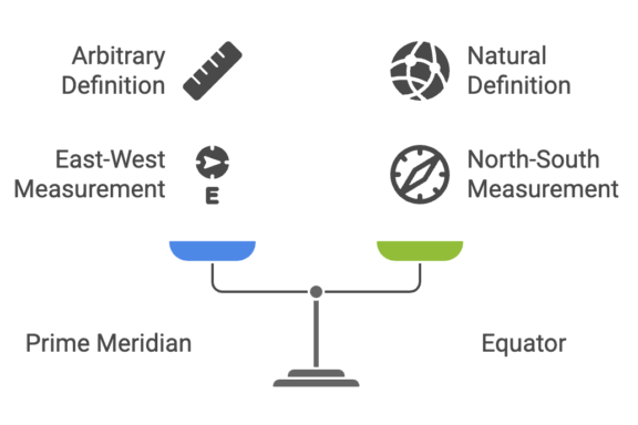
While the Equator is naturally defined by the Earth’s axis of rotation, the Prime Meridian is an arbitrary line, chosen by international agreement.
The History of the Prime Meridian
Early Development at Greenwich Observatory
The story of the Prime Meridian begins in 1675 when King Charles II founded the Royal Observatory in Greenwich, southeast London, to improve naval navigation and establish longitude measurements using astronomy. John Flamsteed was appointed as the first Astronomer Royal in March 1675, and he established the first meridian in 1676.
Over the centuries, multiple meridians were established at Greenwich as newer, more precise instruments replaced older ones. The second meridian was established in 1721 by Edmond Halley, followed by the third meridian in the mid-18th century by James Bradley. Finally, in 1851, Sir George Biddell Airy established the fourth meridian, which became the internationally recognized Prime Meridian.
The International Meridian Conference of 1884
The International Meridian Conference was held in October 1884 in Washington, D.C., at the request of U.S. President Chester A. Arthur. The conference was attended by 41 delegates from 25 nations, with the primary purpose of establishing “a meridian to be employed as a common zero of longitude and standard of time reckoning throughout the world.”
The need for a standardized meridian was driven by the growth of international commerce and the imperative to have all clocks set to a world standard. By the 1880s, most shipping companies already used charts based on the Greenwich Meridian, making it the logical choice for international standardization.
On October 22, 1884, the conference adopted several crucial resolutions. The most significant was the proposal to adopt “the meridian passing through the centre of the transit instrument at the Observatory of Greenwich as the initial meridian for longitude.” This resolution passed with 22 votes in favor, 1 against (San Domingo, now Dominican Republic), and 2 abstentions (France and Brazil).
Why Greenwich Was Selected
Greenwich was chosen as the Prime Meridian for several practical reasons. Most importantly, over two-thirds of all ships already used it as zero longitude, and in 1884, 72% of the world’s trade depended on ships using sea-charts that proclaimed Greenwich as the Prime Meridian. The conference concluded that choosing Greenwich over competitors like Paris and Cadiz would inconvenience fewer people overall.
The Greenwich Observatory best corresponded to the geographical, nautical, astronomical, and cartographic conditions that guided the choice of an international prime meridian, making it the most logical and practical selection for the world standard.
Where is the Prime Meridian Located?
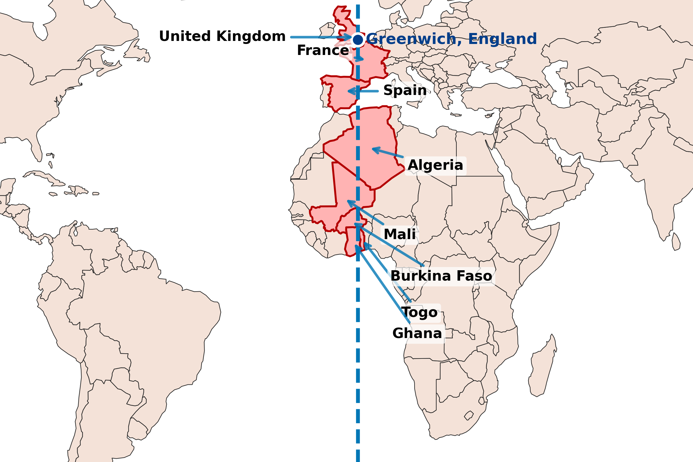
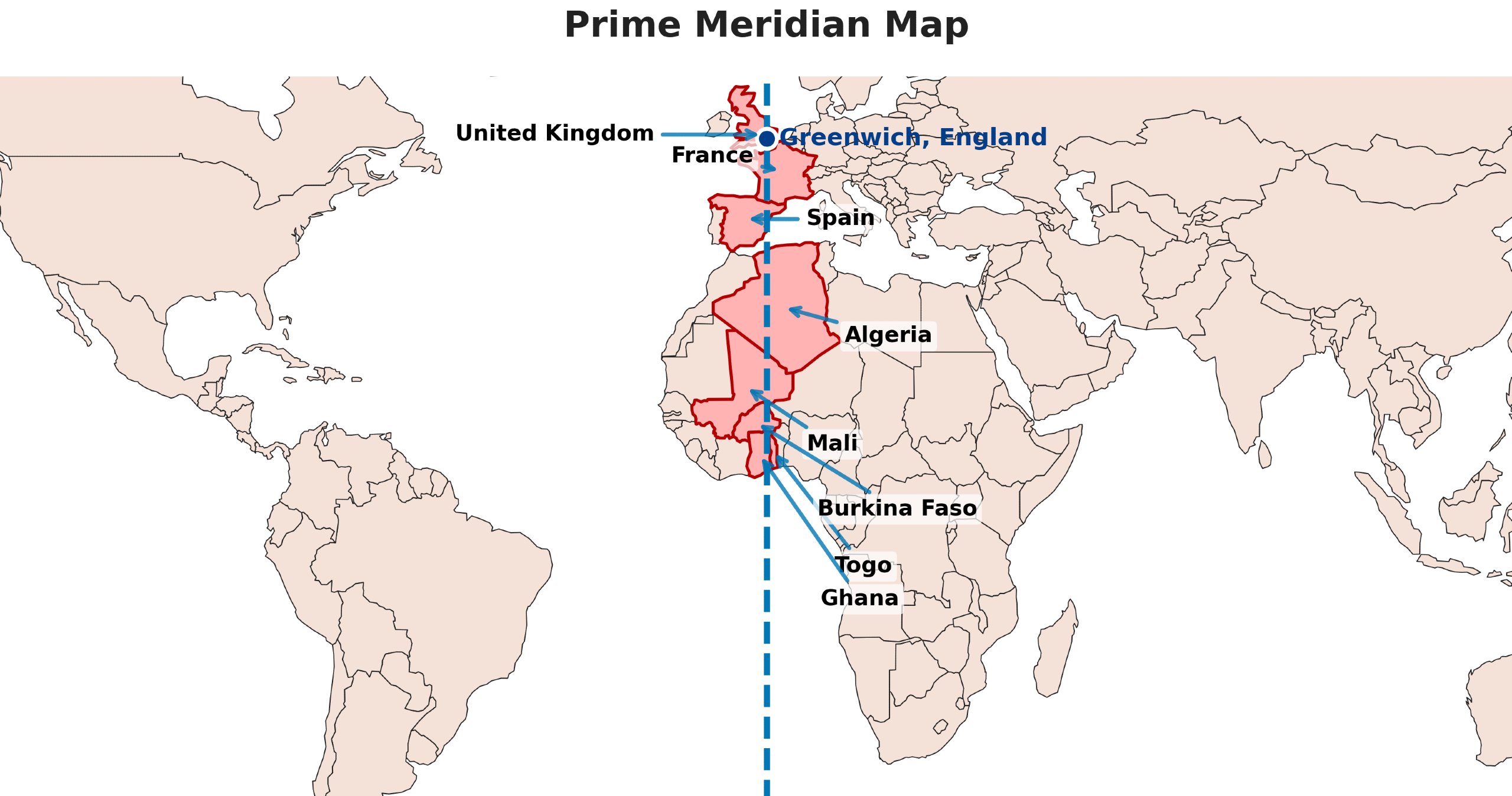
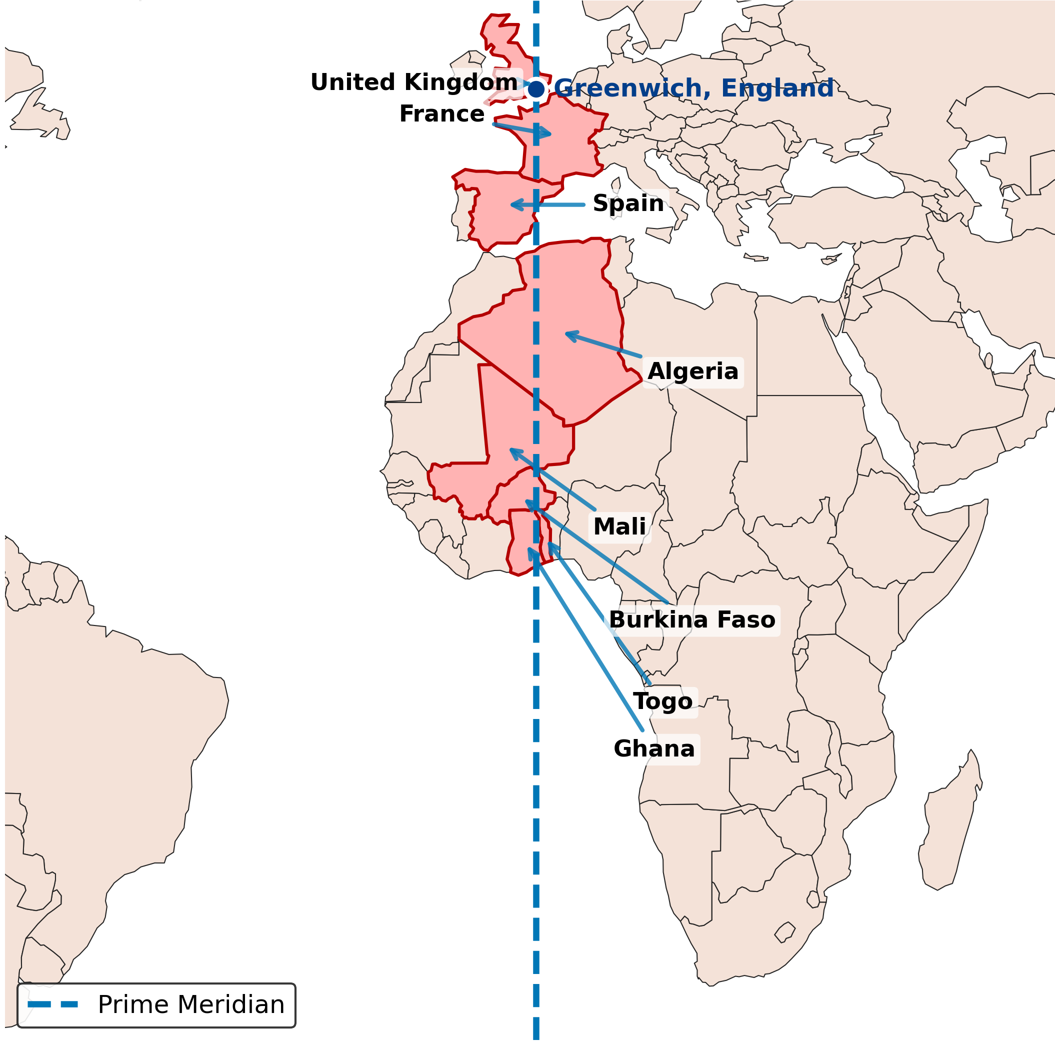
The Prime Meridian runs from the North Pole through Greenwich, a borough of London, England, crossing Europe, Africa, and the Atlantic Ocean, finally reaching the South Pole. This imaginary line passes through eight countries across three continents, creating a fascinating geographical journey from arctic to antarctic regions.
Countries and Territories Along the Prime Meridian
The Prime Meridian passes through the following countries and territories from north to south:
- United Kingdom: Greenwich, London – The historic starting point and home to the Royal Observatory
- France: Passes through northern France including areas near Dunkirk and continues southward
- Spain: Crosses through eastern Spain near Castellón and Valencia
- Algeria: Enters Africa through Algeria, passing through the northern regions
- Mali: Continues through Mali in West Africa
- Burkina Faso: Passes through this landlocked West African nation
- Togo: Crosses through Togo before reaching the Gulf of Guinea
- Ghana: The final African country the Prime Meridian passes through before entering the Atlantic Ocean
- Antarctica: The only landmass crossed by the Prime Meridian in the Southern Hemisphere
Physical Markers at Greenwich
At the Royal Observatory in Greenwich, the Prime Meridian is marked by several physical indicators. The most famous is the brass strip embedded in the courtyard, allowing visitors to stand with one foot in the Eastern Hemisphere and the other in the Western Hemisphere. At night, a green laser beam shoots northward from the observatory, marking the Prime Meridian line across the London sky.
The Prime Meridian is defined by the cross-hairs in the Airy Transit Circle telescope, which was installed in 1851 and continues to serve as the reference point for the historic Prime Meridian.
The Modern Prime Meridian: IERS Reference Meridian
While the historic Greenwich Prime Meridian served as the international standard from 1884 to 1984, modern satellite technology has necessitated a slight adjustment. Since 1984, the official international standard has been the IERS Reference Meridian (International Earth Rotation and Reference Systems Service).
The IERS Reference Meridian passes approximately 102.5 meters (336 feet) east of the historic Prime Meridian at Greenwich. This difference explains why GPS devices and smartphones don’t show exactly 0° longitude when standing on the historic Prime Meridian line at the Royal Observatory.
This offset resulted from improvements in geodetic measurements and the establishment of reference systems for satellite-based navigation systems like GPS, which rely on the World Geodetic System 1984 (WGS-84).
Importance and Applications of the Prime Meridian
Global Navigation and Positioning
The Prime Meridian is essential for global positioning and navigation systems. It serves as the reference point for determining longitude coordinates, which are crucial for:
- Aviation navigation and flight planning
- Maritime navigation and shipping routes
- GPS and satellite navigation systems
- Survey and mapping operations
- Emergency response and search and rescue operations
Time Zones and Coordinated Universal Time (UTC)
The Prime Meridian establishes the foundation for the global time zone system. Greenwich Mean Time (GMT), based on the Prime Meridian, served as the world’s time standard from 1884 to 1972. Today, Coordinated Universal Time (UTC) serves as the primary time standard, with all global time zones calculated as offsets from UTC.
This standardization enables:
- International communication and scheduling
- Global financial markets coordination
- International transportation timetables
- Scientific research and data synchronization
- Internet and telecommunications infrastructure
Mapping and Geographic Information Systems
The Prime Meridian provides the fundamental reference for creating accurate maps and geographic information systems (GIS). It enables cartographers and geographers to create standardized maps that can be used universally, supporting applications in urban planning, environmental monitoring, and political mapping.
Understanding Meridians and the Global Coordinate System
To fully appreciate the Prime Meridian’s significance, it’s essential to understand how it functions within the broader context of Earth’s coordinate system. The global coordinate system combines latitude and longitude to create a comprehensive framework for location identification.
Longitude and Meridians
Longitude lines, also called meridians, are imaginary semicircular lines that run from the North Pole to the South Pole. They measure the angular distance east or west of the Prime Meridian, with measurements ranging from 0° at the Prime Meridian to 180° at the International Date Line on the opposite side of the Earth.
Key characteristics of longitude lines include:
- All meridians are the same length (approximately 20,000 km)
- The distance between meridians varies by latitude, being greatest at the equator and zero at the poles
- Longitude is measured in degrees, minutes, and seconds
- Each degree of longitude represents approximately 111 kilometers at the equator
The Relationship Between Latitude and Longitude
While the Prime Meridian establishes the reference for longitude, it works in conjunction with latitude lines to create a complete coordinate system. Latitude lines run east-west and measure distance north or south of the equator, while longitude lines run north-south and measure distance east or west of the Prime Meridian.
This coordinate system enables precise location identification anywhere on Earth and forms the foundation for modern geography education and navigation technology.
Fascinating Facts About the Prime Meridian
- Multiple Historical Prime Meridians: Before Greenwich became the international standard, different countries used their own prime meridians. France used the Paris Meridian until 1911, while other nations had their own reference points.
- The Airy Transit Circle: The Prime Meridian is defined by the cross-hairs of the Airy Transit Circle telescope, installed in 1851 and named after Sir George Biddell Airy, the seventh Astronomer Royal.
- Tourist Attraction: The Prime Meridian line at Greenwich attracts over 2.5 million visitors annually, making it one of London’s most popular tourist destinations.
- Solar Noon Connection: The term “meridian” comes from the Latin “meridies” (midday) because the sun reaches its highest point in the sky when it crosses a meridian.
- The International Date Line: The Prime Meridian’s opposite point at 180° longitude serves as the basis for the International Date Line, where each new day begins.
- Precision Evolution: Modern GPS technology has revealed that the historic Prime Meridian differs from the current standard by about 102.5 meters due to advances in geodetic science.
- Cultural Impact: The Prime Meridian has been featured in numerous works of literature, including novels by Jules Verne and appears in countless films and documentaries about navigation and exploration.
How to Find and Use the Prime Meridian
Locating the Prime Meridian on Maps
The easiest way to locate the Prime Meridian on any map is to find the 0° longitude line. This line runs vertically through Greenwich, England, and clearly separates the eastern and western halves of world maps. On most maps, the Prime Meridian is marked with a bold line or special notation to distinguish it from other meridians.
When using digital mapping tools or GPS devices, you can search for coordinates 51.4769° N, 0.0000° W to find the exact location of the Prime Meridian at Greenwich.
Using Longitude for Navigation
Understanding longitude and the Prime Meridian is crucial for navigation. To use longitude effectively:
- Determine your longitude coordinate using a GPS device or map
- Compare your longitude to your destination’s longitude
- Remember that longitude coordinates increase as you move east from the Prime Meridian
- Use both latitude and longitude coordinates for precise positioning
Educational Resources and Further Learning
For those interested in learning more about the Prime Meridian and geography, several excellent resources are available:
- Royal Observatory Greenwich: Visit the official website and physical location to explore interactive exhibits and educational materials
- Geography Education: Enhance your understanding with geography board games and educational resources
- Interactive Maps: Explore various regional maps to understand how the Prime Meridian relates to different parts of the world
- Educational Institutions: Many universities offer courses in geography, cartography, and navigation that cover the Prime Meridian in detail
Conclusion
The Prime Meridian stands as one of humanity’s most important geographical achievements, representing the successful international cooperation to create a unified global standard for navigation and timekeeping. From its establishment at the 1884 International Meridian Conference to its evolution into today’s IERS Reference Meridian, this imaginary line has shaped how we understand and navigate our world.
Understanding the Prime Meridian’s history, location, and significance provides valuable insight into geography, navigation, and international cooperation. Whether you’re planning a trip to stand on the famous line at Greenwich Observatory, studying geography, or simply curious about how our world is organized, the Prime Meridian remains a fundamental concept that continues to connect us in our increasingly globalized world.
As technology continues to advance and our understanding of Earth’s geography becomes more precise, the Prime Meridian’s role as a reference point for global navigation, timekeeping, and scientific research remains as important as ever. This remarkable invisible line serves as a testament to human ingenuity and our ongoing quest to understand and navigate our planet.
References and Sources
- Royal Museums Greenwich – What is the Prime Meridian?
- Britannica – Greenwich Meridian
- International Meridian Conference – Wikipedia
- Britannica – Meridian Geography
- National Geographic Education – Prime Meridian
- NOAA Ocean Service – What is longitude?
Image Sources and Copyright Information
- Prime Meridian Map: © Mappr
- Prime Meridian Map Horizontal: © Mappr