As one of the oldest countries in the world, India has an epic history reflected in each of its 28 states and 8 union territories.
Some of these regions are home to some of the most densely populated cities in the world, and each has its own traditions, languages, and cultures.
In this post, we’ll see a political map of India that details each of the country’s 28 states and 8 union territories. We will then go into greater detail about each administrative division in India, learning about what makes each one unique.
States and Union Territories in India
States and union territories are the largest administrative divisions in India. They can both be further divided into districts, and each has a capital city.
The primary difference between states and union territories in India is that states have a higher degree of self-governance.
States have state governments that share governing powers with the union government. Union territories are governed by the union government, also known as the Government of India.
Political Map of India

It’s important to note that the exact borders in the northernmost parts of India have been disputed for many years. India, China, and Pakistan all claim some of the same territory as their own. Our map attempts to recognize the changing, uncertain nature of the region.
States of India
| State | Capital | Official Language(s) |
|---|---|---|
| Andhra Pradesh | Amaravati | Telugu, Urdu |
| Arunachal Pradesh | Itanagar | English |
| Assam | Dispur | Assamese, Boro, Bengali |
| Bihar | Patna | Hindi, Urdu |
| Chhattisgarh | Raipur | Hindi, Chhattisgarhi |
| Goa | Panaji | Konkani, Marathi |
| Gujarat | Gandhinagar | Gujarati, Hindi |
| Haryana | Chandigarh | Hindi, Punjabi |
| Himachal Pradesh | Shimla | Hindi, Sanskrit |
| Jharkhand | Ranchi | Hindi, Angika, Bengali, Bhojpuri, Bhumij, Ho, Kharia, Khortha, Kurmali, Kurukh, Magahi, Maithili, Mundari, Nagpuri, Odia, Santali, Urdu |
| Karnataka | Bengaluru | Kannada |
| Kerala | Thiruvananthapuram | Malayalam, English |
| Madhya Pradesh | Bhopal | Hindi |
| Maharashtra | Mumbai | Marathi |
| Manipur | Imphal | Meiteilon, English |
| Meghalaya | Shillong | English |
| Mizoram | Aizawl | Mizo, English |
| Nagaland | Kohima | English |
| Odisha | Bhubaneswar | Odia |
| Punjab | Chandigarh | Punjabi |
| Rajasthan | Jaipur | Hindi |
| Sikkim | Gangtok | English, Nepali, Sikkimese, Lepcha, Gurung, Limbu, Magar, Mukhia, Newari, Rai, Sherpa, Tamang |
| Tamil Nadu | Chennai | Tamil, English |
| Telangana | Hyderabad | Telugu, Urdu |
| Tripura | Agartala | Bengali, Kokborok, English |
| Uttar Pradesh | Lucknow | Hindi, Urdu |
| Uttarakhand | Dehradun | Hindi, Sanskrit |
| West Bengal | Kolkata | Bengali, Nepali, English, Hindi, Odio, Punjabi, Santali, Telugu, Urdu, Kamatapuri, Rajbanshi, Kurmali, Kurukh |
Andhra Pradesh

Andhra Pradesh, located in the southeastern part of India, is known for its rich cultural heritage and significant historical background. The state was formed on November 1, 1956, and is notable for being the first state in India to be created based on linguistic lines, reflecting the predominantly Telugu-speaking population.
Its capital, Amaravati, is an emerging global city with deep historical roots, especially in Buddhism. Andhra Pradesh is renowned for its classical dance form, Kuchipudi, which holds a distinguished place in Indian culture. The state is also famous for its unique cuisine, particularly for its spicy pickles and mouth-watering biryanis.
Geographically, it is characterized by the Eastern Ghats and a long coastline along the Bay of Bengal. The state is also home to the Tirumala Venkateswara Temple in Tirupati, one of the world’s most visited religious sites.
Arunachal Pradesh

Arunachal Pradesh, located in the northeastern part of India, is renowned for its untouched natural beauty and diverse cultural tapestry.
Established as a state on February 20, 1987, it is often referred to as the “Land of the Dawn-Lit Mountains,” as it is the first Indian state to greet the rising sun. The state’s capital, Itanagar, is named after the historical Ita Fort, dating back to the 14th century.
Arunachal Pradesh is distinguished by its diverse tribal culture, with more than 26 major tribes and over 100 sub-tribes, each having its own unique customs, languages, and dresses. This diversity is celebrated in various colorful festivals like Losar, Solung, and Reh, which are integral to the state’s identity.
The state is also home to the Namdapha National Park, one of India’s largest protected areas, hosting an array of wildlife, including the elusive snow leopard and the red panda.
Assam

Nestled in the northeastern region of India, Assam is known for its rich biodiversity, and vibrant culture. Established as a constituent state of India in 1950, it is particularly famous for Assam tea and Assam silk, both of which are integral to its economy and identity.
The state’s capital, Dispur, serves as a gateway to the Northeast. Assam is also home to the ancient city of Guwahati, which houses the revered Kamakhya Temple, a significant site for Hindu pilgrims.
This region is also famous for the Kaziranga National Park, a UNESCO World Heritage Site known for its population of the Indian one-horned rhinoceros, a species once on the brink of extinction.
Bihar

Established as a state of independent India in 1950, Bihar is known as the birthplace of Buddhism and Jainism. The ancient city of Patna, Bihar’s capital, stands on the southern bank of the Ganges and has a history that extends back to the days of the Magadha empire.
Bihar is celebrated for its Madhubani art, a traditional form of painting known for its vibrant colors and intricate patterns, often depicting mythological and folk themes. This art form, originating from the Mithila region, is a significant cultural symbol of the state.
Bihar is also known for historical sites like the Archaeological Site of Nalanda, one of the world’s oldest universities, and Bodh Gaya, where Lord Buddha attained enlightenment under the Bodhi tree.
Chhattisgarh

Chhattisgarh was formed on November 1, 2000, carved out of Madhya Pradesh to become the 26th state of India. The state’s capital, Raipur, is a major administrative and industrial hub.
Chhattisgarh is celebrated for its tribal culture, which constitutes a significant part of its population. These tribal communities have their unique traditions, dances, music, and festivals, adding to the state’s diverse cultural fabric. The state is also known for its traditional handicrafts, especially Dhokra metal craft, known for its intricate designs and antiquity.
Geographically, Chhattisgarh is rich in minerals and dense forests, housing a significant portion of India’s coal and iron ore reserves. The state also boasts of natural beauty with waterfalls like Chitrakote and dense forests in the Bastar region, making it a haven for nature enthusiasts.
Goa

Goa, India’s smallest state by area, is situated on the western coast, known for its stunning beaches, vibrant nightlife, and rich Portuguese heritage. Goa became a part of India in 1961, following 450 years of Portuguese rule, which significantly influenced its architecture, cuisine, and culture.
The state’s capital, Panaji, is known for its old-world charm, with colorful Portuguese-style buildings and the serene Mandovi River.
Goa is a major global tourist destination, famous for its picturesque beaches like Baga and Anjuna, and historic sites such as the Basilica of Bom Jesus, a UNESCO World Heritage Site. The state is also celebrated for its annual Goa Carnaval and the lively Sunburn Festival, attracting tourists from around the world.
Gujarat

Gujarat, located on the western coast of India, is known for its vibrant culture, rich history, and economic prowess. Established as a state in 1960, Gujarat is the birthplace of Mahatma Gandhi, the leader of the Indian independence movement. The state’s capital, Gandhinagar, is named after him and is known for its architectural beauty and planning.
Gujarat is famous for its diverse and colorful festivals, notably Navratri, celebrated with great fervor and featuring traditional dance forms like Garba and Dandiya. The state is also renowned for its unique textile industry, producing exquisite fabrics and traditional crafts like Bandhani and Patola silk.
The state’s geographical landscape includes the Rann of Kutch, a vast salt marsh known for its surreal beauty, especially during the Rann Utsav Festival. Gujarat’s long coastline has been historically significant for trade and commerce.
Haryana

Haryana, located in North India, is a state known for its rich cultural heritage and substantial contribution to agriculture in India. Formed on November 1, 1966, Haryana surrounds the national capital Delhi on three sides, forming its northern, western, and southern borders.
The state’s capital, Chandigarh, is shared with Punjab and is famed for its modernist architecture and urban design by Le Corbusier.
Historically significant, Haryana is believed to be a site of the ancient Indus Valley Civilization and the epic battle of Mahabharata at Kurukshetra. The state is also known for its contributions to sports in India, particularly in wrestling and boxing, producing numerous athletes who have represented India on international platforms.
Himachal Pradesh

Himachal Pradesh, nestled in the Western Himalayas, is renowned for its breathtaking mountain landscapes. Established as a full-fledged state in 1971, it is characterized by its picturesque hill stations, ancient temples, and diverse flora and fauna.
Himachal Pradesh is a haven for adventure enthusiasts, offering opportunities for trekking, mountaineering, paragliding, and skiing, especially in areas like Kullu, Manali, and Dharamshala. The state is also famous for its traditional handicrafts, including Pahari paintings, woolen shawls, and wooden crafts.
Himachal Pradesh is also known for its religious tourism, with prominent temples like the Jwala Ji Temple, and the abode of the Dalai Lama in McLeod Ganj, attracting spiritual seekers globally.
Jharkhand

Jharkhand, carved out of Bihar in 2000, is situated in eastern India, known for its rich mineral resources and tribal heritage. The state’s capital, Ranchi, is a major industrial center, also famous for its waterfalls and lush greenery.
The state’s landscape is dominated by forests, hills, and rivers, making it rich in natural beauty and wildlife. Jharkhand hosts Betla National Park, one of India’s earliest tiger reserves, and the scenic Dalma Wildlife Sanctuary.
Jharkhand is also significant in India’s mining sector, contributing a large portion of the country’s coal, iron ore, and copper production. The state’s festivals, like Sarhul and Karma, reflect the deep connection of its people with nature and their ancestral traditions.
Karnataka

Officially established in 1956, Karnataka is celebrated for its architectural heritage, including the ruins of the Vijayanagara Empire in Hampi and the intricately carved temples of Belur and Halebidu.
Bengaluru, the state’s capital, is often dubbed the “Silicon Valley of India.” It is a major center for the IT industry, attracting talent and businesses globally. Karnataka is also known for its diverse linguistic and cultural landscape, with Kannada being the predominant language.
The state’s geography features a varied landscape, from the beaches of the Arabian Sea coastline to the lush Western Ghats mountain range. Karnataka is home to several national parks and wildlife sanctuaries, including Bandipur and Nagarhole, which are part of the Nilgiri Biosphere Reserve.
Kerala

Kerala, nestled along the southwestern coast of India, is renowned for its lush landscapes, backwaters, and rich cultural heritage. Formed in 1956, it’s often referred to as “God’s Own Country.” The state’s capital, Thiruvananthapuram, is known for its historic temples and vibrant arts scene.
Kerala is celebrated for its unique backwaters, a network of interconnected canals, rivers, lakes, and inlets. These backwaters are a major tourist attraction, with houseboats offering serene and scenic views of the countryside. The state is also famous for its picturesque hill stations like Munnar and its diverse wildlife, found in sanctuaries like Periyar and Wayanad.
Culturally, Kerala has a rich tradition in the performing arts, notably the Kathakali and Mohiniyattam dance forms.
Madhya Pradesh

Madhya Pradesh, located in central India, is known for its rich history and diverse wildlife. Established in 1956, its capital, Bhopal, blends historical heritage with modern urban planning. The state is famed for housing the Khajuraho Group of Monuments, a UNESCO World Heritage Site known for its ancient temples with intricate erotic sculptures.
Madhya Pradesh is also renowned for its national parks, including Bandhavgarh, Kanha, and Pench, which inspired Rudyard Kipling’s “The Jungle Book.” These parks are home to a significant population of Bengal tigers and other wildlife species.
Madhya Pradesh’s Gwalior and Indore are significant for their historical and cultural importance, with Gwalior’s fort and Indore’s palaces drawing visitors.
Maharashtra
 in Mumbai, India")
Maharashtra, located in the western region of India, is a state of diverse cultures, bustling cities, and significant historical sites. Established in 1960, its capital, Mumbai, is the country’s financial and entertainment hub, home to the Bollywood film industry.
The state boasts impressive historical structures, including the ancient Ajanta and Ellora Caves, UNESCO World Heritage Sites known for their stunning rock-cut architecture and exquisite murals. Maharashtra’s coastline along the Arabian Sea is dotted with pristine beaches and historic forts.
Culturally, Maharashtra is celebrated for its festivals, especially Ganesh Chaturthi, marked with grandeur and devotion. The state’s cuisine, characterized by its mild and aromatic dishes, reflects its diverse demographics.
Manipur

Manipur, a northeastern state of India, received statehood in 1927 and is renowned for its natural beauty. Its capital, Imphal, is encircled by hills and is known for its historical and cultural significance. Manipur is especially famous for its classical dance form, Manipuri, characterized by its grace and themes rooted in Vaishnavism.
The state is home to the Loktak Lake, the largest freshwater lake in northeastern India, known for its unique floating islands called “phumdis.” The Keibul Lamjao National Park, the world’s only floating national park, is located on this lake and is the last natural habitat of the endangered Sangai deer.
Manipur’s diverse ethnic groups contribute to a rich mosaic of traditions, languages, and crafts. The state celebrates several festivals, with the Yaoshang Festival being one of the most prominent.
Meghalaya

Meghalaya, meaning “abode of clouds” in Sanskrit, is a state in northeastern India known for its picturesque landscapes and rich cultural heritage. Formed in 1972, it is predominantly inhabited by the Khasi, Jaintia, and Garo tribes, each with their unique traditions and customs. The state’s capital, Shillong, is known as the “Scotland of the East” for its rolling hills and pleasant climate.
Culturally, Meghalaya is known for its vibrant festivals, like the Nongkrem dance festival, which showcase the rich tribal heritage and traditional music and dance of the region. The state’s cuisine, influenced by its tribal cultures, is rich in flavors and includes a variety of meat, fish, and rice-based dishes.
Mizoram

Mizoram was established as a state in 1987 and is characterized by its hilly terrain, lush green forests, and an array of rivers and waterfalls. The state is a haven for nature lovers and adventure seekers, with opportunities for trekking and bird-watching. Aizawl is its capital city.
Culturally, Mizoram is rich in folk dances and music, integral to the Mizo community’s social gatherings and festivals. The Chapchar Kut festival, a spring festival celebrated with great enthusiasm, showcases traditional dances, costumes, and music.
Mizoram is known for its peaceful society, high literacy rate, and strong sense of community. The state’s cuisine is unique, with an emphasis on non-vegetarian dishes, using bamboo shoots and local herbs, reflecting its tribal influences and natural bounty.
Nagaland

Nagaland, located in the far northeastern part of India, is known for its diverse indigenous cultures and vibrant festivals. Established as a state in 1963, it is home to various tribes, each with distinct languages, customs, and traditional attire. The state’s capital, Kohima, is steeped in history, particularly noted for the pivotal Battle of Kohima during World War II.
The state is famous for the Hornbill Festival, often called the “Festival of Festivals,” which showcases the rich cultural heritage of the Naga tribes. Held annually in the first week of December, it brings together different Naga tribes in a celebration of their traditions, including music, dance, and local cuisine.
Odisha

Odisha, located on the eastern coast of India, is renowned for its rich cultural heritage and historical significance. Established in 1936, the state’s capital, Bhubaneswar, is often referred to as the “Temple City of India,” hosting hundreds of ancient temples, including the famous Lingaraja Temple.
Odisha is celebrated for its classical dance form, Odissi, one of the oldest dance forms in India, known for its grace and expressiveness. The state is also home to the Sun Temple at Konark, a UNESCO World Heritage Site, acclaimed for its unique architecture and intricate carvings.
The state’s coastline along the Bay of Bengal includes beautiful beaches like Puri Beach, a sacred place for Hindu pilgrims. Odisha’s Jagannath Temple in Puri is renowned for its annual Rath Yatra, a chariot festival attracting thousands of devotees.
Punjab
 Reflecting in the Sacred Pool under a Blue Sky")
Punjab, located in the northwestern part of India, is known for its rich cultural heritage, vibrant festivals, and significant agricultural contributions. Established as a state in 1966, its capital, Chandigarh, is renowned for its modern architecture and urban planning.
Punjab is often referred to as India’s “Granary,” owing to its substantial agricultural output, particularly in wheat and rice production.
The state is celebrated for its Bhangra dance and music, integral to Punjabi culture and festivities. Punjab is also famous for the Golden Temple in Amritsar, the most sacred Sikh Gurudwara, attracting pilgrims from all over the world.
Punjab’s history is marked by the stories of Sikh Gurus and freedom fighters. The Jallianwala Bagh in Amritsar is a significant historical site, symbolizing the Indian struggle for independence.
Rajasthan

Rajasthan, located in the northwestern part of India, is known for its rich history, grand palaces, and vibrant culture. Established in 1956, it is the largest Indian state by area. The state’s capital, Jaipur, also known as the “Pink City,” is famous for Hawa Mahal and Amer Fort.
Rajasthan is celebrated for its traditional art forms, including Rajasthani music, dance, and handicrafts like block printing, blue pottery, and jewelry making.
The state boasts several UNESCO World Heritage Sites, such as the Jantar Mantar in Jaipur and the Hill Forts of Rajasthan. Rajasthan’s colorful festivals, like Pushkar Camel Fair and Desert Festival, showcase its rich traditions and attract tourists globally.
Sikkim

Sikkim, nestled in the eastern Himalayas, is known for its breathtaking natural beauty and rich Buddhist culture. Incorporated into India as its 22nd state in 1975, Sikkim’s capital, Gangtok, offers stunning views of the Kanchenjunga, one of the highest mountains in the world.
Buddhism plays a significant role in Sikkim’s cultural landscape, evident in its numerous monasteries, like Rumtek and Pemayangtse. The state celebrates unique festivals like Losar, marking the Tibetan New Year, and Saga Dawa, celebrating the birth, enlightenment, and death of Buddha.
Sikkim’s cuisine reflects its Nepalese, Tibetan, and indigenous influences, known for dishes like momos and thukpa.
Tamil Nadu

Tamil Nadu, located in the southernmost part of India, is known for its rich Dravidian culture, ancient temples, and artistic heritage. Established in 1956, its capital, Chennai, is a major cultural, economic, and educational center. Tamil Nadu is renowned for its classical dance form, Bharatanatyam, and music, integral to its cultural identity.
The state boasts a wealth of ancient Hindu temples with Dravidian architecture, like the Meenakshi Amman Temple in Madurai and Brihadeeswarar Temple in Thanjavur, a UNESCO World Heritage Site. Tamil Nadu’s coastline, along the Bay of Bengal, includes the popular Marina Beach in Chennai.
Tamil literature, one of the oldest in India, plays a significant role in the state’s cultural landscape. The state celebrates various festivals, with Pongal being the most prominent, marking the harvest season.
Telangana

Telangana, located in southern India, was formed as a separate state from Andhra Pradesh in 2014, making it one of the newest states in India. Its capital, Hyderabad, is a major center for the technology industry and is known for its rich history, cuisine, and the iconic Charminar.
The state is celebrated for its distinctive culture, which includes unique festivals like Bonalu and Bathukamma, reflecting the local traditions and spiritual beliefs.
Geographically, Telangana is characterized by its diverse landscapes, from the Deccan Plateau to dense forests and river valleys. The state is home to several historic sites, including the Golconda Fort and the Ramappa Temple, a UNESCO World Heritage Site.
Tripura

Tripura, located in Northeast India, is known for its rich cultural heritage and diverse landscapes. It became a full-fledged state in 1972. Agartala, the state capital, is known for its palaces and temples, including the Ujjayanta Palace, a former royal abode turned museum.
Tripura is home to a variety of ethnic groups, each contributing to the state’s multicultural tapestry. The state is celebrated for its traditional music, dance forms like the Hojagiri, and handicrafts, especially bamboo and cane work.
The state’s natural beauty includes the Neermahal, a water palace situated in the middle of Rudrasagar Lake, and the Jampui Hills, known for their scenic vistas and orange orchards.
Uttar Pradesh

The state of Uttar Pradesh is located in the northern part of India. Established in 1950, its capital, Lucknow, is renowned for its exquisite Mughal architecture, cuisine, and the classical dance form Kathak.
Uttar Pradesh is home to Varanasi, one of the world’s oldest continuously inhabited cities and a major spiritual center for Hindus. The state also hosts the city of Agra, famed for the iconic Taj Mahal, a UNESCO World Heritage Site and symbol of love.
The state plays a pivotal role in Indian politics and has been a cradle of Indian civilization and culture. It is the birthplace of Lord Rama and Lord Krishna, key figures in Hindu mythology, with places like Ayodhya and Mathura holding immense religious significance.
Uttarakhand

Nestled in the northern part of India, Uttarakhand is known for its stunning natural beauty and spiritual significance. Formed in 2000 from the hilly regions of Uttar Pradesh, its capital, Dehradun, is a picturesque city surrounded by mountains.
The state is often referred to as “Devbhoomi,” meaning “Land of the Gods,” due to its numerous Hindu temples and pilgrimage centers. It is home to the Char Dham, four sacred pilgrimage sites — Yamunotri, Gangotri, Kedarnath, and Badrinath — that hold great significance in Hinduism.
The state is also known for its rich biodiversity, with two of India’s largest national parks, Jim Corbett and Rajaji, providing habitats for diverse wildlife, including the Bengal tiger and Asiatic elephants.
West Bengal

West Bengal, located in eastern India, is known for its rich cultural heritage, intellectual history, and artistic contributions. Established in 1947 following India’s partition, its capital, Kolkata (formerly Calcutta), is renowned as a cultural and intellectual hub, once the capital of British India.
West Bengal is celebrated for its significant contributions to Indian literature, arts, and cinema, with figures like Rabindranath Tagore, a Nobel laureate, shaping its cultural landscape. The state is famous for its Durga Puja festival, a grand and vibrant celebration of the goddess Durga, attracting visitors globally.
The Sundarbans, the world’s largest mangrove forest and a UNESCO World Heritage Site, is located in West Bengal. This unique ecosystem is home to the Royal Bengal Tiger and a diverse range of flora and fauna.
Union Territories of India
| Union Territory | Capital | Official Language(s) |
|---|---|---|
| Andaman and Nicobar Islands | Port Blair | Hindi, English |
| Chandigarh | Chandigarh | English |
| Dadra and Nagar Haveli and Daman and Diu | Daman | Gujarati, Hindi, Konkani, Marathi, English |
| Delhi | New Delhi | Hindi, English, Punjabi, Urdu |
| Jammu and Kashmir | Srinagar (Summer), Jammu (Winter) | Kashmiri, Dogri, Urdu, Hindi, English |
| Ladakh | Leh | Ladakhi, Tibetan, Hindi, English |
| Lakshadweep | Kavaratti | Malayalam |
| Puducherry | Pondicherry | Tamil, Malayalam, Telugu, English, French |
Andaman and Nicobar Islands

The Andaman and Nicobar Islands, an Indian union territory, are a group of picturesque islands located in the Bay of Bengal. Known for their pristine beaches — such as Radhanagar Beach on Havelock Island — clear waters, and vibrant coral reefs, these islands are a paradise for nature lovers and adventure enthusiasts.
The capital, Port Blair, is known for the historic Cellular Jail, a symbol of India’s freedom struggle. The territory’s indigenous tribes, with their distinct cultures, add to the region’s uniqueness.
Chandigarh

Chandigarh, another union territory in India, serves as the capital of both Punjab and Haryana. The city is known for landmarks like the Rock Garden, an open-air exhibition hall featuring sculptures made from industrial and home waste, and the Sukhna Lake, a popular spot for relaxation and water activities.
Chandigarh’s layout is complemented by its wide boulevards, numerous gardens, and the Shivalik Range in the backdrop, making it a unique blend of nature and urbanity.
The territory also boasts a high standard of living and cleanliness, attracting tourists and residents alike for its orderly beauty and tranquil environment. Chandigarh’s culture reflects a blend of traditional Punjabi spirit and contemporary lifestyle.
Dadra and Nagar Haveli and Daman and Diu

Dadra and Nagar Haveli and Daman and Diu, a union territory in India, consists of two separate regions near the west coast. Known for their scenic landscapes and Portuguese colonial heritage, these areas blend cultural influences from Gujarat and Maharashtra with their own unique traditions.
Daman is famed for its beaches and colonial forts, while Diu is noted for its old Portuguese Cathedral and the Diu Fort. Dadra and Nagar Haveli, nestled between Maharashtra and Gujarat, is known for its lush greenery and indigenous tribal communities.
These regions offer a mix of natural beauty and historical sites, making them popular tourist destinations. The blend of different cultural influences is reflected in the territory’s architecture, cuisine, and festivals.
Delhi

Delhi, India’s capital territory, is a city steeped in history, yet brimming with modern life. It’s a blend of ancient monuments and bustling urban sprawl. The city is divided into two parts: Old Delhi, a labyrinth of narrow lanes, old havelis, and vibrant markets; and New Delhi, the tree-lined, spacious capital city designed by British architects Lutyens and Baker.
Famous landmarks in Delhi include the Red Fort, India Gate, Qutub Minar, and the Lotus Temple. As a political hub, Delhi hosts important government buildings like the Parliament of India.
The city is a melting pot of cultures and cuisines, offering everything from street food to fine dining experiences. Delhi’s rich history, diverse culture, and dynamic character make it a microcosm of India itself.
Jammu and Kashmir

Jammu and Kashmir, reorganized as a union territory in 2019, is renowned for its breathtaking natural beauty, with picturesque valleys, serene lakes, and snow-capped mountains. The region is divided into two distinct parts: the Jammu division, known for its temples and pilgrimage sites like Vaishno Devi; and the Kashmir Valley, famed for its scenic vistas, gardens, and the iconic Dal Lake.
The capital cities, Srinagar in the summer and Jammu in the winter, each offer unique cultural and natural experiences. Srinagar is famous for its traditional houseboats and shikara rides on Dal Lake, while Jammu is a hub for pilgrims.
Ladakh

Ladakh, established as a union territory in 2019, is known for its stark, breathtaking landscapes and rich Buddhist culture. Located in the northernmost part of India, it comprises two districts: Leh and Kargil. Leh, the capital, is famous for its Buddhist monasteries, notably Thiksey and Hemis, and the Shanti Stupa.
Ladakh’s terrain is dominated by rugged mountains, pristine lakes like Pangong Tso, and high-altitude deserts, making it a haven for adventure enthusiasts. The region’s culture is deeply influenced by Tibetan Buddhism, evident in its festivals, architecture, and monasteries.
Lakshadweep

Lakshadweep, India’s smallest Union Territory, is an archipelago consisting of 36 islands in the Arabian Sea. Known for its stunning coral reefs, crystal-clear waters, and white sandy beaches, it’s a tropical paradise and a popular destination for water sports enthusiasts.
Kavaratti, the capital, is home to beautiful mosques and an aquarium showcasing local marine life. The islands are known for their rich marine biodiversity, including a variety of coral species, making it an ideal spot for snorkeling and scuba diving.
Puducherry

Puducherry, formerly known as Pondicherry, is a Union Territory on the southeastern coast of India. It’s famed for its French colonial heritage, evident in its architecture, tree-lined streets, and chic boutiques. The capital, also named Puducherry, is divided into two sections: the French and Tamil Quarters, each with distinct charms.
Puducherry is known for Aurobindo Ashram and Auroville, an experimental township dedicated to human unity and peace. The city’s promenade along the Bay of Bengal is a popular spot for both locals and tourists.


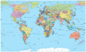


- Colorful Political Map of India Highlighting States and Neighboring Countries — © Mappr
- Devotees Visiting the Famous Tirupati Temple in Andhra Pradesh, India — © Rahul D Silva/Shutterstock
- Colorful Prayer Flags Fluttering at a Snow-Covered Buddhist Gateway in Tawang, Arunachal Pradesh, India — © Dhruba Jyoti Baruah/Shutterstock
- Sunrise Over Lush Green Tea Plantation in Assam — © NATNN/Shutterstock
- Ancient Ruins of Nalanda University in Bihar, India — © explorewithinfo/Shutterstock
- Panoramic View of Chitrakot Waterfall with Rainbow Arc — © Bappa Pabitra/Shutterstock
- Sunset View of the Historic Basilica in Old Goa, India — © Paulharding00/Shutterstock
- Traditional Gujarati Women in Colorful Attire on the Salt Flats — © mridulablog/Shutterstock
- Serene Sunset at Brahma Sarovar with Temple, Kurukshetra, India — © Sourabh Patiyal Designs/Shutterstock
- Hillside Buildings in Dharamsala with the Himalayan Mountains in the Background — © hecke61/Shutterstock
- Misty Hilltop Temple in Dalma Wildlife Sanctuary, Jharkhand — © Arnav Pratap Singh/Shutterstock
- Sunset Over the Virupaksha Temple Amidst the Hampi Ruins in Karnataka, India — © Roop_Dey/Shutterstock
- Sunset Over the Lush Tea Plantations of Munnar, Kerala, India — © Mazur Travel/Shutterstock
- Majestic View of Gwalior Fort at Sunset in Madhya Pradesh, India — © ImagesofIndia/Shutterstock
- Twilight View of Chhatrapati Shivaji Maharaj Terminus (CST) in Mumbai, India — © paul prescott/Shutterstock
- Scenic View of Loktak Lake with Floating Islands and Lush Greenery in Manipur, India — © Nongamba Sorokhaibam/Shutterstock
- Majestic Nohkalikai Waterfall Amidst Lush Greenery in Meghalaya, India — © Jyotismita Baruah/Shutterstock
- Panoramic View of Aizawl City at Sunrise with Mist Over the Hills — © Nomad1988/Shutterstock
- Serene War Cemetery with Lush Greenery Overlooking a Hillside Town — © Richard Sebastian/Shutterstock
- 11th-Century Lingaraja Hindu Temple at Sunrise in Odisha, India — © ShaikhMeraj/Shutterstock
- Golden Temple (Harmandir Sahib) Reflecting in the Sacred Pool under a Blue Sky — © Kavkirat Kaur/Shutterstock
- Aerial View of the Majestic Jaigarh Fort Overlooking a Lake in Jaipur, Rajasthan — © Roop_Dey/Shutterstock
- Majestic Buddha Statue Overlooking the Himalayas in Ravangla, Sikkim — © saiko3p/Shutterstock
- Scenic View of Kookal Village Amidst Terraced Fields and Misty Hills in Kodaikanal, Tamil Nadu — © Lalu369/Shutterstock
- Illuminated Charminar and Bustling Night Market in Hyderabad, India — © prudhvichowdary/Shutterstock
- Tourists Walking Towards the Ujjayanta Palace in Agartala, Tripura, India — © balajisrinivasan/Shutterstock
- Historic Gateway and Bustling Street Scene in Lucknow, Uttar Pradesh — © PradeepGaurs/Shutterstock
- Confluence of Two Rivers in a Scenic Uttarakhand Valley with Colorful Houses — © Vivek BR/Shutterstock
- Iconic Yellow Taxis and Bustling Street Scene in Front of a Grand Colonial-Era Building in Kolkata, India — © Roop_Dey/Shutterstock
- Serene Beachfront with Lush Greenery on a Sunny Day — © lego 19861111/Shutterstock
- Artistic Stone Sculptures Displayed Outdoors — © Martchan/Shutterstock
- Colorful Boats on the Shoreline with Cityscape in the Background — © O'SHI/Shutterstock
- India Gate and Canopy in New Delhi on a Sunny Day — © Richie Chan/Shutterstock
- Colorful Shikaras on Dal Lake with Snow-Capped Himalayas in the Background, Srinagar, Jammu and Kashmir — © ImagesofIndia/Shutterstock
- Group of Travelers by a Serene High-Altitude Lake in the Majestic Mountains of Ladakh — © chris piason/Shutterstock
- Tropical Beach Scene with Tourists and Boats at Kalpeni Island, Lakshadweep — © sixpixx/Shutterstock
- Basilica of the Sacred Heart of Jesus in Puducherry, India — © Lalam photography/Shutterstock