
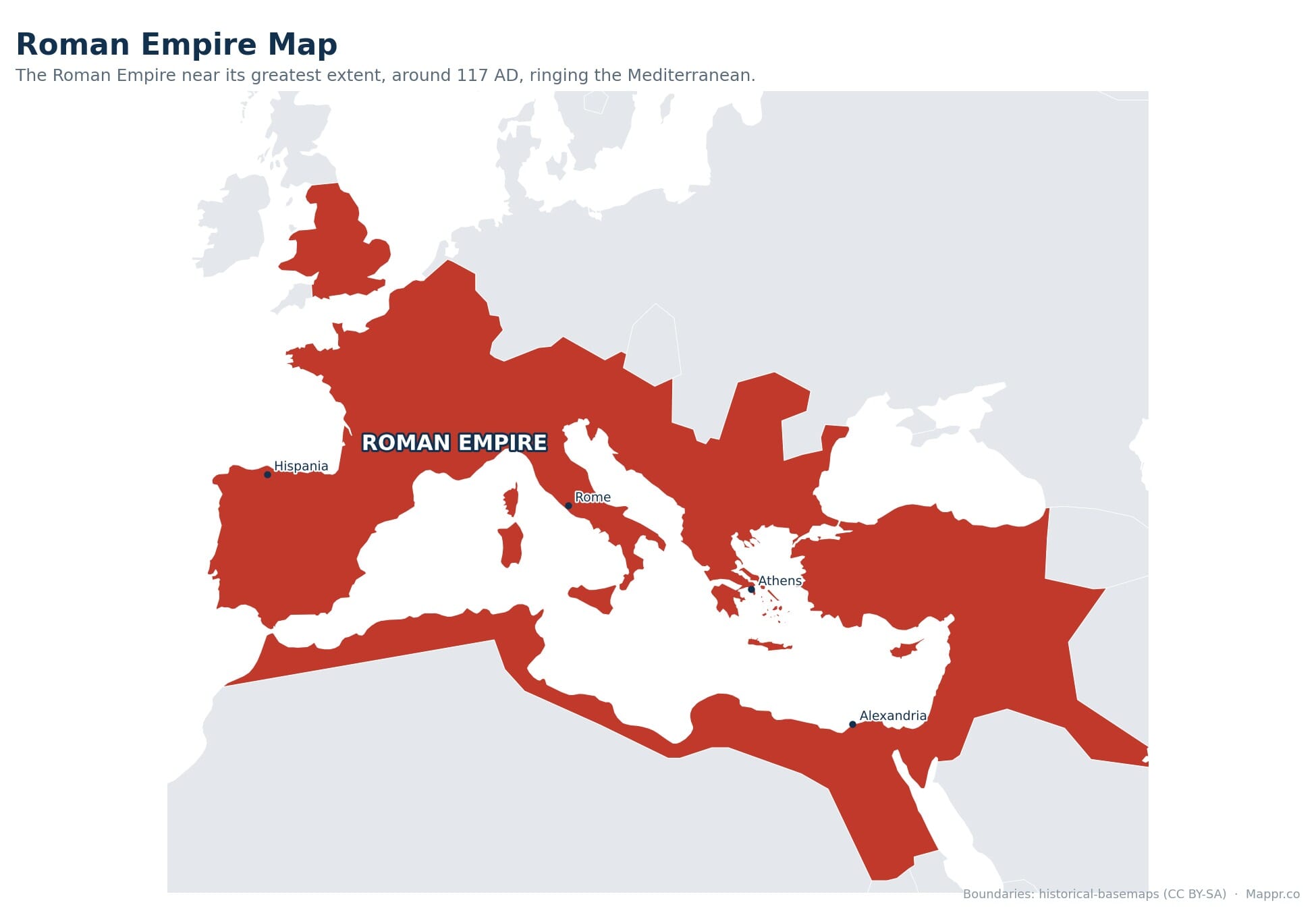
The Roman Empire grew out of the Roman Republic in 27 BCE, when the Senate handed Octavian the title Augustus and Rome moved from rule by elected magistrates to rule by one man. From its capital in Italy it eventually controlled the entire rim of the Mediterranean, a sea the Romans called mare nostrum, our sea. At its largest it stretched from the north of Britain to the edge of the Sahara, and from the Atlantic coast of Portugal to the Persian Gulf.
The empire reached its greatest extent in 117 CE, in the final months of Trajan’s reign, covering roughly 5 million square kilometres and holding somewhere between 50 and 70 million people, perhaps a fifth of everyone alive at the time. It was split into eastern and western halves in 395 CE, the western half ended in 476 CE, and the eastern half carried on from Constantinople for almost another thousand years until 1453.
The Roman Empire at a Glance
- Founded 27 BCE, capital Rome. On 16 January 27 BCE the Senate granted Octavian the name Augustus. He governed as princeps, first citizen, rather than king, and historians treat that year as the start of the empire.
- About 5 million km2 at its peak. The empire was at its largest in 117 CE under Trajan, after the conquests of Dacia, Armenia, Mesopotamia and Assyria. His successor Hadrian gave up most of the eastern gains within months.
- Roughly 50 to 70 million people. Estimates vary widely because Rome counted citizens rather than everyone. Around 45 to 50 provinces were governed from Rome, with Egypt, Asia, Africa Proconsularis and Syria the richest.
- Split east and west in 395 CE. When Theodosius I died in January 395 the empire passed to his sons, Honorius in the west and Arcadius in the east. Contemporaries saw one empire with two courts, not two states.
- Around 45 modern countries. Land once ruled from Rome now sits inside about 45 present day states across Europe, North Africa and western Asia, from Britain and Morocco to Iraq and Egypt.
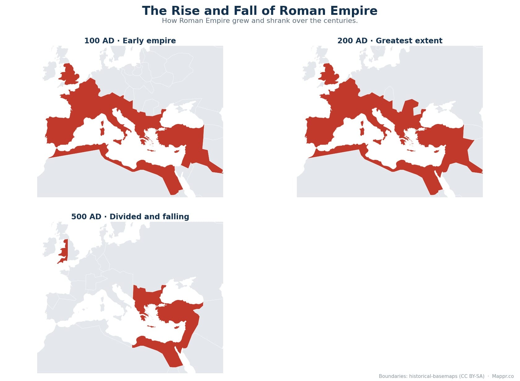
The Rise and Fall of Roman Empire, Mapped
The sequence below traces the same territory across four moments, from the young empire under Augustus to the divided state of late antiquity.
From Republic to Empire, 27 BCE
Rome had already conquered most of the Mediterranean as a republic. Carthage fell in 146 BCE, Greece was absorbed the same year, Gaul was taken by Julius Caesar between 58 and 50 BCE, and Egypt was annexed in 30 BCE after the defeat of Antony and Cleopatra. What changed in 27 BCE was who held power at home, not how much land Rome held abroad.
On 16 January 27 BCE Octavian staged a formal handover of his powers to the Senate, which promptly handed them back along with the honorific Augustus. The republic was never abolished on paper. In practice one man now controlled the army, the treasury and the provinces that mattered, and the system he built, the Principate, lasted three centuries.
Augustus pushed the frontier to the Danube and tried to reach the Elbe, but the loss of three legions in the Teutoburg Forest in 9 CE fixed the northern border on the Rhine. Britain was invaded in 43 CE under Claudius. By the time the Flavian emperors were finished, Rome ruled a continuous belt of territory around the entire Mediterranean.
The Peak: Trajan and the Empire of 117 CE
Trajan, emperor from 98 to 117 CE, was the last Roman ruler to expand the empire on a large scale. He conquered Dacia, roughly modern Romania, in two wars between 101 and 106 CE, and the gold that came out of the Dacian mines paid for a building programme that included his column and forum in Rome. Arabia Petraea, covering modern Jordan and the Sinai, was annexed the same year.
Between 114 and 117 CE Trajan campaigned east against Parthia and briefly created the provinces of Armenia, Mesopotamia and Assyria, reaching the Persian Gulf. That is the moment the map above captures. Roman control of those eastern provinces was thin and short lived, and revolts had already broken out when Trajan died in August 117.
His successor Hadrian abandoned the Mesopotamian conquests almost immediately and spent his reign fortifying what was left. Construction of Hadrian’s Wall across northern Britain began in 122 CE. From that point the empire was a defensive project rather than an expanding one.
At this peak the empire ran about 45 to 50 provinces. Governors reported to Rome, legions were stationed on the frontiers rather than in the interior, and a road network of roughly 80,000 kilometres tied the provinces together. Major cities included Rome, Alexandria, Antioch, Carthage, Ephesus, Londinium, Lugdunum and Byzantium, the last of which would later be rebuilt as Constantinople.
Crisis, Recovery and a Second Capital
The second century ended well and the third nearly ended the empire. In 212 CE Caracalla extended Roman citizenship to almost every free inhabitant, a change that redefined what being Roman meant. Then came the Crisis of the Third Century, roughly 235 to 284 CE: dozens of claimants to the throne, plague, currency debasement, Germanic and Persian invasions, and breakaway regimes in Gaul and Palmyra.
Diocletian, emperor from 284, held it together by reorganising almost everything. He doubled the number of provinces, separated civil and military commands, and in 293 CE set up the Tetrarchy, rule by two senior and two junior emperors covering different regions. The idea that the empire needed more than one ruler to function dates from here.
Constantine reunited the empire under one emperor, legalised Christianity with the Edict of Milan in 313 CE, and on 11 May 330 CE dedicated a new capital at Byzantium, renamed Constantinople. The centre of gravity had moved east, where the cities were larger, the tax base deeper and the trade routes richer.
The Division of 395 CE and the Fall of the West
When Theodosius I died on 17 January 395 CE, the empire passed to his two sons: Honorius took the west, ruling from Milan and later Ravenna, and Arcadius took the east from Constantinople. It is worth being precise about this. No law split the empire in two, and Romans at the time still spoke of a single empire with two imperial courts. What made 395 the definitive date is that the halves were never again ruled by one emperor.
The western half then unravelled fast. The Rhine frontier was overrun in 406 CE. Alaric and the Visigoths sacked Rome in 410 CE, the first time the city had fallen to a foreign army in eight centuries. Britain was abandoned around the same time, North Africa and its grain supply were lost to the Vandals by 439 CE, and the Vandals sacked Rome again in 455 CE.
On 4 September 476 CE the Germanic commander Odoacer deposed the teenage emperor Romulus Augustulus and sent the imperial regalia to Constantinople rather than appointing a replacement. That is the conventional end date for the Western Roman Empire, though the western court had been a shell for decades and Julius Nepos, deposed in 475, kept a claim to the title in Dalmatia until 480.
The eastern half did not fall. It kept calling itself Roman, and historians call it the Byzantine Empire largely for convenience. Justinian reconquered Italy, North Africa and southern Spain in the sixth century before losing most of it again. Constantinople finally fell to Mehmed II on 29 May 1453, which is why some historians date the true end of the Roman Empire to that year rather than 476.
What Rome Left Behind
The clearest legacy is linguistic. Spanish, Portuguese, French, Italian and Romanian all descend from spoken Latin, and the Latin alphabet is now the most widely used writing system on earth. Roman law forms the backbone of the civil law tradition used across continental Europe and Latin America.
The physical infrastructure is still visible: the Pont du Gard in France, the aqueduct at Segovia, Hadrian’s Wall, the amphitheatre at El Djem in Tunisia, and the Pantheon in Rome, which has held the record for the world’s largest unreinforced concrete dome since 126 CE. Many European capitals began as Roman camps or colonies, including London, Paris, Vienna, Belgrade and Cologne.
The title itself outlived the state. The Holy Roman Empire claimed the name until 1806, Ottoman sultans styled themselves Caesar of Rome after 1453, and both Kaiser and Tsar are derived from Caesar.
Modern Countries Today
Territory the Roman Empire held at some point between 27 BCE and 476 CE now lies inside roughly 45 sovereign states. The table below groups them by region and notes what Rome actually controlled there. Borders shifted constantly across five centuries, so a country appearing here does not mean all of its modern territory was Roman.
| Modern Country | Region | Roman Territory |
|---|---|---|
| Italy | Europe | The Italian heartland, including Rome, Ravenna and Milan |
| Vatican City | Europe | Inside the city of Rome |
| San Marino | Europe | Enclosed by Roman Italy |
| Malta | Europe | Melita, taken from Carthage in 218 BCE |
| Greece | Europe | Provinces of Achaea, Macedonia and Epirus |
| Cyprus | Europe | Annexed 58 BCE, a senatorial province |
| Spain | Europe | Hispania, almost the whole peninsula |
| Portugal | Europe | Lusitania and part of Gallaecia |
| Andorra | Europe | Pyrenean fringe of Hispania Tarraconensis |
| France | Europe | Gaul, conquered by Caesar 58 to 50 BCE |
| Monaco | Europe | Portus Herculis Monoeci on the Gallic coast |
| Belgium | Europe | Gallia Belgica |
| Netherlands | Europe | South of the Rhine only |
| Luxembourg | Europe | Gallia Belgica |
| United Kingdom | Europe | England and Wales, plus southern Scotland at times |
| Germany | Europe | West of the Rhine and south of the Danube |
| Switzerland | Europe | Raetia and Germania Superior |
| Liechtenstein | Europe | Province of Raetia |
| Austria | Europe | Noricum and part of Pannonia |
| Slovenia | Europe | Pannonia and eastern Italia |
| Croatia | Europe | Dalmatia and Pannonia |
| Bosnia and Herzegovina | Europe | Dalmatia |
| Montenegro | Europe | Dalmatia and Praevalitana |
| Serbia | Europe | Moesia Superior, birthplace of Constantine |
| Kosovo | Europe | Dardania, part of Moesia |
| North Macedonia | Europe | Province of Macedonia |
| Albania | Europe | Illyricum and Epirus Nova |
| Hungary | Europe | Pannonia, west of the Danube |
| Slovakia | Europe | A narrow Danube frontier zone only |
| Romania | Europe | Dacia, held 106 to about 271 CE |
| Moldova | Europe | Briefly on the Dacian frontier |
| Bulgaria | Europe | Moesia and Thrace |
| Turkey | Asia | Asia Minor, and Constantinople from 330 CE |
| Georgia | Asia | Colchis and Lazica, largely as client territory |
| Armenia | Asia | A client kingdom, briefly a province 114 to 117 CE |
| Syria | Asia | Province of Syria, with Antioch as a major capital |
| Lebanon | Asia | Phoenicia, including Berytus and its law school |
| Israel | Asia | Judaea, later Syria Palaestina |
| Palestine | Asia | Judaea and Samaria |
| Jordan | Asia | Arabia Petraea, annexed 106 CE |
| Iraq | Asia | Mesopotamia, held briefly 116 to 117 CE |
| Egypt | Africa | Aegyptus, annexed 30 BCE, Rome’s grain supply |
| Libya | Africa | Cyrenaica and Tripolitania |
| Tunisia | Africa | Africa Proconsularis, centred on rebuilt Carthage |
| Algeria | Africa | Numidia and Mauretania Caesariensis |
| Morocco | Africa | Mauretania Tingitana, the northern strip only |
| Sudan | Africa | A short lived frontier zone in northern Nubia |
A few entries are deliberately marginal. Slovakia, Moldova and Sudan sit on frontier zones Rome patrolled or briefly occupied rather than governed as settled provinces, and Iraq and Armenia were Roman for only about three years at the very peak. Kuwait and Saudi Arabia appear on some maps of Trajan’s Persian Gulf campaign, but there is no good evidence of lasting Roman administration there, so they are left out here.
Boundaries on the maps above are reconstructed from historical datasets and should be read as approximate. Roman authority ranged from directly governed provinces to client kingdoms and loosely patrolled frontier zones, and the desert, mountain and forest edges of the empire were never surveyed as lines on a map. Published maps of 117 CE therefore differ from one another, particularly in Mesopotamia, Armenia, Nubia and northern Britain. Sources and further reading:
Map Data and Image Sources
- historical-basemaps (CC BY-SA 4.0) – historical boundary data used for the empire outline, licensed CC BY-SA 4.0
- Map created by Mappr – cartography and design


