
The Ottoman Empire was one of the longest lived states in world history, ruling from northwest Anatolia across three continents for more than six centuries. It was founded around 1299 by Osman I, the leader of a small Turkish principality in northwestern Anatolia, and it ended formally when the sultanate was abolished on 1 November 1922. At its height the empire governed the Balkans, Anatolia, the Levant, Mesopotamia, much of the Arabian Peninsula and the North African coast, with Constantinople, today Istanbul, as its capital after 1453.
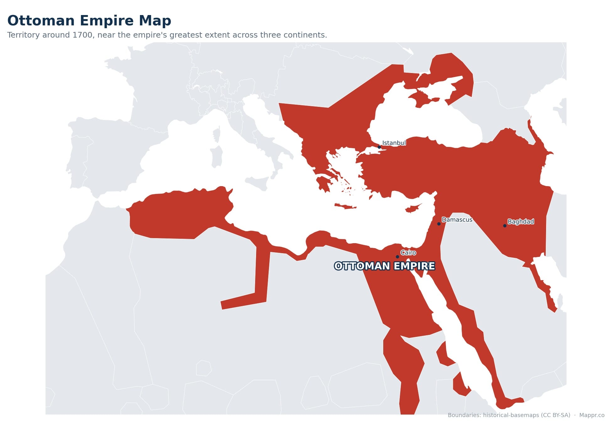
The map below shows the Ottoman world at roughly its largest, around 1683, when the territory it controlled or claimed covered close to 5.2 million square kilometres. That figure is an estimate rather than a survey. Ottoman power was layered, with directly governed provinces at the core and tributary states such as the Crimean Khanate, Wallachia, Moldavia and the North African regencies at the edges, so any single line on a historical map is a simplification of a frontier that moved constantly.
The Ottoman Empire at a Glance
- Capital: Constantinople from 1453. The Ottomans ruled first from Bursa, then Edirne, then Constantinople, now Istanbul, after Mehmed II captured the city on 29 May 1453.
- Founded c. 1299, dissolved 1922. Osman I founded the state around 1299. The sultanate was abolished on 1 November 1922 and the caliphate followed on 3 March 1924, ending roughly 623 years of Ottoman rule.
- About 5.2 million km2 at its peak. Around 1683 the empire spanned southeastern Europe, western Asia and North Africa, one of the few states in history to hold major territory on three continents at once.
- Vienna 1683 was the turning point. The failed second siege of Vienna in September 1683 began sixteen years of war that ended with the Treaty of Karlowitz in 1699 and the loss of Hungary and Transylvania.
- Roughly 30 modern countries. Territory once held or claimed by the Ottomans now lies in about 30 present day states, from Hungary and Algeria to Iraq and Yemen, with Turkey as the direct successor.
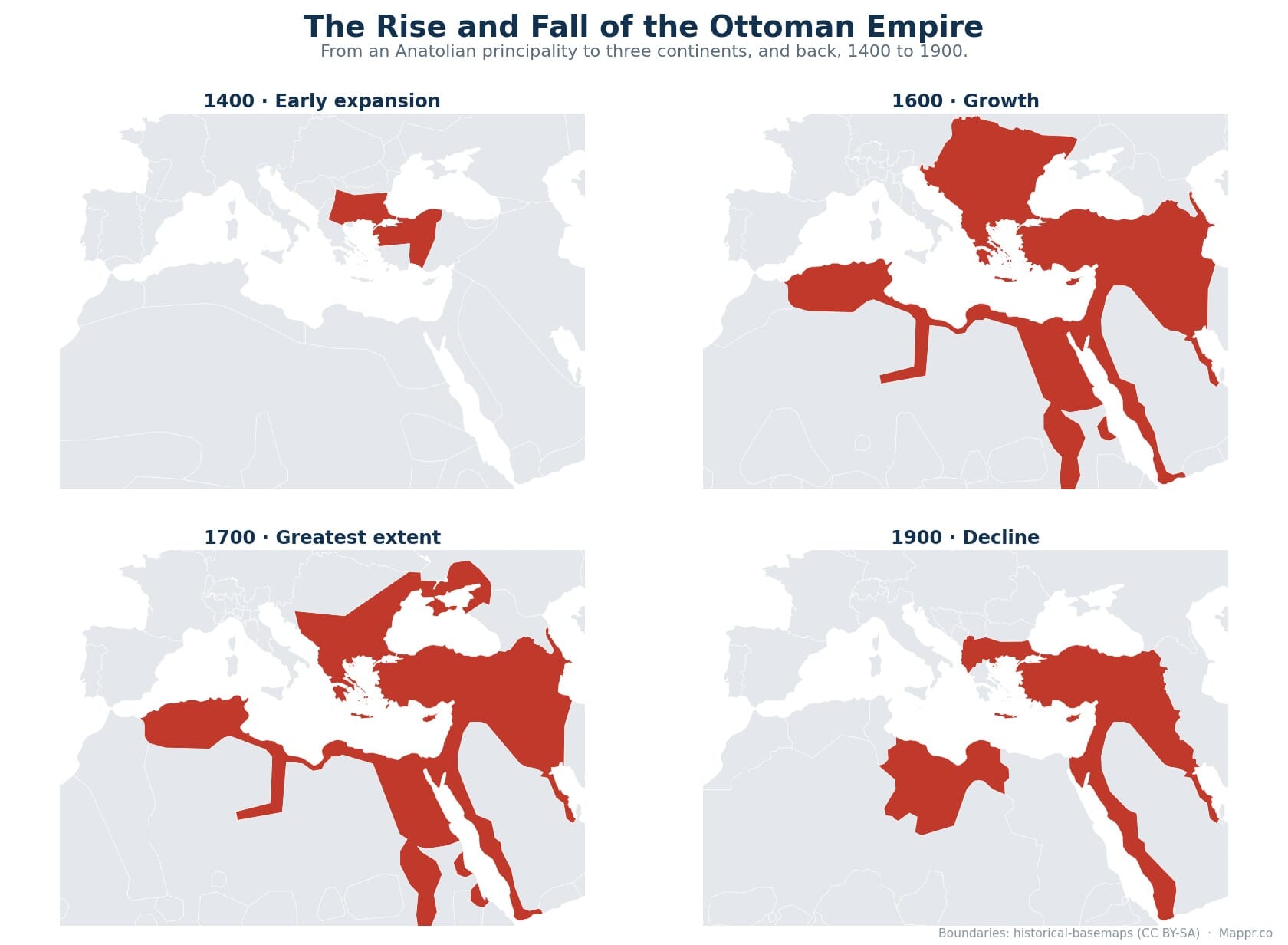
The Rise and Fall of the Ottoman Empire, Mapped
The empire was never static. It grew from a small Anatolian principality into a power spanning three continents, then slowly contracted over its final centuries. These four snapshots show that arc at a glance.
Foundation and Early Expansion, 1299 to 1453
The Ottoman state began as one of many small Turkish principalities that filled the vacuum left by the collapse of the Seljuk Sultanate of Rum in Anatolia. Osman I, who ruled from about 1299 to 1326, held a modest frontier territory near the Byzantine border. His successors turned that position into a systematic expansion.
Bursa fell in 1326 and became the first Ottoman capital. The Ottomans crossed into Europe in the 1350s, took Adrianople, now Edirne, in 1369 and made it the new seat of government. Victories at Kosovo in 1389 and Nicopolis in 1396 established Ottoman dominance in the Balkans. A serious setback came in 1402, when Timur defeated Sultan Bayezid I at Ankara and the empire fragmented into a decade of civil war.
Mehmed I, who ruled from 1413 to 1421, reunited the realm and is often called the second founder of the empire. The defining moment came on 29 May 1453, when Mehmed II captured Constantinople after a siege of nearly two months. The fall of the city ended the Byzantine Empire and gave the Ottomans a capital that sat astride the land and sea routes between Europe and Asia.
The Golden Age Under Selim I and Suleiman the Magnificent
The empire’s fastest growth came in the sixteenth century. Selim I, who ruled from 1512 to 1520, defeated the Safavids at Chaldiran in 1514, then destroyed the Mamluk Sultanate in 1516 and 1517. Those campaigns brought Syria, Palestine, the Hejaz and Egypt under Ottoman rule and roughly tripled the size of the state in under a decade. Control of Mecca and Medina also gave the sultans custodianship of Islam’s holiest cities.
Suleiman the Magnificent, who ruled from 1520 to 1566, presided over the empire’s cultural and military peak. He took Belgrade in 1521 and Rhodes in 1522 and 1523, crushed the Hungarian army at Mohacs in 1526, and pushed as far as Vienna in 1529, where the first siege failed. Baghdad was taken in 1534. Ottoman fleets and their North African allies dominated much of the Mediterranean, though the naval defeat at Lepanto in 1571 showed the limits of that reach.
Greatest Extent and the Turn at Vienna, 1683
The empire reached its maximum territorial extent in 1683, covering roughly 5.2 million square kilometres. From Buda in central Hungary to Basra on the Persian Gulf, and from the Crimean steppe to the Algerian coast, Ottoman authority or overlordship stretched across Europe, Asia and Africa. The population is estimated at around 30 million by 1600.
That peak lasted only weeks. Grand Vizier Kara Mustafa Pasha besieged Vienna from July 1683 and was routed on 12 September 1683 by a relief army of Habsburg, German and Polish forces under King John III Sobieski. The defeat triggered the long war with the Holy League. By the Treaty of Karlowitz, signed on 26 January 1699, the Ottomans gave up Hungary, Transylvania, Podolia and most of the Peloponnese. It was the first treaty in which the empire negotiated as a defeated power.
It is worth being careful about what greatest extent means here. Much of the outer territory shown on maps of 1683 was held through vassals and semi autonomous regencies rather than direct provincial administration, and desert frontiers in Arabia and North Africa were zones of influence rather than surveyed borders.
The Long Retreat, 1699 to 1913
The eighteenth and nineteenth centuries were a slow contraction under pressure from Russia, Austria and rising nationalism. Russia annexed the Crimean Khanate, a long standing Ottoman vassal, in 1783. Serbia won autonomy through uprisings beginning in 1804. Greece secured independence after the war that began in 1821, recognised by the London Protocol of 1830. France took Algiers in 1830 and Tunisia in 1881.
The Congress of Berlin in 1878 was the sharpest single loss in Europe. Romania, Serbia and Montenegro became fully independent, Bulgaria became autonomous, Austria Hungary occupied Bosnia and Herzegovina, and Britain took over the administration of Cyprus. Britain occupied Egypt in 1882, though it remained nominally Ottoman until 1914. Italy seized Libya in 1911 and 1912.
The Balkan Wars of 1912 and 1913 stripped away almost all remaining European territory. By the Treaty of London and the settlement that followed, the empire kept only eastern Thrace around Edirne on the European side of the straits.
World War I and Dissolution, 1914 to 1924
The Ottomans entered the First World War on the side of the Central Powers in October and November 1914. The war brought both the successful defence of the Dardanelles at Gallipoli in 1915 and 1916 and the loss of the Arab provinces to British and Arab forces. It also brought the Armenian genocide of 1915 and 1916, in which around a million or more Armenians were killed or died during deportations.
The Armistice of Mudros on 30 October 1918 ended Ottoman participation in the war, and Allied forces occupied Constantinople. The Treaty of Sevres of 10 August 1920 would have partitioned Anatolia itself, but it was never ratified and was overtaken by the Turkish War of Independence led by Mustafa Kemal.
The Grand National Assembly abolished the sultanate on 1 November 1922. The Treaty of Lausanne, signed on 24 July 1923, replaced Sevres and set the borders of the new state. The Republic of Turkey was proclaimed on 29 October 1923, and the caliphate was abolished on 3 March 1924.
Modern Countries Today
Territory once ruled or claimed by the Ottoman Empire now falls within roughly 30 present day countries. The list below covers the whole span of Ottoman history rather than a single year, since the empire never held all of it at once. Dates are approximate, and several entries were vassal or autonomous rather than directly governed.
| Present-day country | Region | Approx. Ottoman period | Notes |
|---|---|---|---|
| Turkey | Anatolia and Thrace | c. 1299 to 1922 | Core of the empire and its direct successor state |
| Greece | Southeast Europe | c. 1450s to 1913 | Independent from 1830, final territories in 1913 |
| Bulgaria | Southeast Europe | 1396 to 1878 | Autonomous 1878, fully independent 1908 |
| Serbia | Southeast Europe | 1459 to 1878 | Autonomous from 1830, independent 1878 |
| Romania | Southeast Europe | c. 1400s to 1878 | Wallachia and Moldavia were tributary, Dobruja directly ruled |
| Bosnia and Herzegovina | Southeast Europe | 1463 to 1878 | Occupied by Austria Hungary 1878, annexed 1908 |
| North Macedonia | Southeast Europe | 1395 to 1912 | Lost in the First Balkan War |
| Albania | Southeast Europe | c. 1415 to 1912 | Declared independence November 1912 |
| Kosovo | Southeast Europe | 1455 to 1912 | Partially recognised state, independence declared 2008 |
| Montenegro | Southeast Europe | c. 1499 to 1878 | Mountain interior remained effectively autonomous |
| Croatia | Southeast Europe | c. 1520s to 1699 | Slavonia and parts of the interior, lost at Karlowitz |
| Hungary | Central Europe | 1541 to 1699 | Central Hungary ruled from Buda |
| Slovakia | Central Europe | 1663 to 1685 | Southern strip only, the short lived Eyalet of Uyvar |
| Moldova | Eastern Europe | c. 1538 to 1812 | Part of tributary Moldavia, Bessarabia ceded to Russia in 1812 |
| Ukraine | Eastern Europe | c. 1475 to 1783 | Southern coast and Crimea, largely through the Crimean Khanate |
| Russia | Eastern Europe | c. 1475 to 1783 | Kuban and Azov areas, mostly through Crimean vassalage |
| Cyprus | Eastern Mediterranean | 1571 to 1878 | British administration from 1878, annexed 1914 |
| Georgia | Caucasus | c. 1550s to 1878 | Western and southwestern districts, contested with Persia and Russia |
| Armenia | Caucasus | c. 1550s to 1918 | Western Armenia, frontier long contested with Persia |
| Azerbaijan | Caucasus | intermittent, 1578 to 1735 | Held only during wars with the Safavids |
| Syria | Levant | 1516 to 1918 | French mandate after the war |
| Lebanon | Levant | 1516 to 1918 | Mount Lebanon had special autonomous status from 1861 |
| Israel and the Palestinian territories | Levant | 1516 to 1917 | British mandate for Palestine after the war |
| Jordan | Levant | 1516 to 1918 | Became Transjordan under British mandate |
| Iraq | Mesopotamia | 1534 to 1918 | Provinces of Mosul, Baghdad and Basra |
| Saudi Arabia | Arabian Peninsula | 1517 to 1918, with gaps | Hejaz and al-Hasa, interior Najd rarely controlled |
| Yemen | Arabian Peninsula | 1538 to 1636, 1849 to 1918 | Highlands frequently outside effective control |
| Kuwait | Arabian Peninsula | 1871 to 1913 | Nominal suzerainty, British protectorate from 1899 |
| Qatar | Arabian Peninsula | 1871 to 1913 | Nominal Ottoman garrison at Doha |
| Egypt | North Africa | 1517 to 1914 | Effectively autonomous from 1805, British occupied 1882 |
| Libya | North Africa | 1551 to 1912 | Lost to Italy in the Italo Turkish War |
| Tunisia | North Africa | 1574 to 1881 | Autonomous beylik, French protectorate from 1881 |
| Algeria | North Africa | 1516 to 1830 | Regency of Algiers, largely self governing, taken by France |
| Sudan | Northeast Africa | 1821 to 1885 | Ruled through Ottoman Egypt |
| Eritrea | Northeast Africa | 1557 to the 1800s | Red Sea coast only, the Habesh eyalet |
A handful of other places saw brief or purely coastal Ottoman presence, including parts of Bahrain, the United Arab Emirates, Somalia and Djibouti, and Poland through the province of Podolia between 1672 and 1699. They are usually left off summary maps because the control was short lived or nominal.
Legacy and How to Read Ottoman Maps
The borders drawn across the former Arab provinces after 1918, shaped by the Sykes Picot understanding of 1916 and the mandate system, still define much of the modern Middle East. In the Balkans, the sequence of independence movements between 1804 and 1913 produced the state pattern that survived, with revisions, through the twentieth century.
When reading any map of the empire, treat the outline as a best estimate. Ottoman administration recognised several grades of authority, from directly taxed provinces to tribute paying principalities and nominal suzerainty over distant ports. Historical boundary datasets reconstruct these lines from written sources and inevitably smooth over shifting, contested and sometimes undefined frontiers. Small differences between published maps of the same year are normal.
Boundaries on the map above are reconstructed from historical datasets and should be read as approximate. Ottoman authority ranged from directly governed provinces to tributary states and nominal suzerainty, and frontier zones in Arabia, North Africa and the Caucasus were never surveyed, so published maps of the same year often differ. Sources and further reading:
Map Data and Image Sources
- historical-basemaps (CC BY-SA 4.0) – historical boundary data used for the empire outline, licensed CC BY-SA 4.0
- Map created by Mappr – cartography and design


