Key Takeaways
- Cyclone Akvan is heading for India's Andhra Pradesh coast. The India Meteorological Department expects it to strengthen into a very severe cyclonic storm and make landfall between Nellore and Tuni around noon on 20 November.
- Winds of 120 to 130 km/h, gusting to 145 km/h. Heavy to very heavy rain is forecast for coastal Andhra Pradesh on 19 and 20 November, with isolated extremely heavy falls. Fishermen have been told to stay ashore.
- It is the third cyclone to target this coast in about a month. Cyclone Arnab made landfall near Kakinada on 28 October and Cyclone Murasu near Ongole on 3 November. Together they killed 15 people.
- This page updates automatically. The live map refreshes every three hours with the storm's latest position, forecast track and uncertainty cone.
Latest (updated 17 November 2026, morning IST)
- Cyclonic Storm Akvan has formed over the southeast Bay of Bengal and is moving north-northwest toward the Andhra Pradesh coast.
- Forecast landfall: between Nellore and Tuni, around noon on 20 November, as a very severe cyclonic storm with sustained winds of 120 to 130 km/h, gusting to 145 km/h.
- Warnings: heavy to very heavy rain on 19 and 20 November across coastal Andhra Pradesh, with heavy rain also possible in Odisha. Fishermen have been advised not to venture out to sea.
A third cyclone in about a month is bearing down on India’s east coast. Cyclonic Storm Akvan strengthened from a deep depression over the southeast Bay of Bengal and is now tracking north-northwest toward Andhra Pradesh, the same coastline battered by Cyclones Arnab and Murasu since late October.
The India Meteorological Department (IMD) expects Akvan to intensify into a very severe cyclonic storm before crossing the coast between Nellore and Tuni around noon on 20 November, with sustained winds of 120 to 130 km/h and gusts to 145 km/h. Preparations are under way along a roughly 500 km stretch of coastline.
Live Tracker: Where Is Cyclone Akvan Now?
The live map shows Akvan’s current position, its track so far, the official forecast track and the cone of uncertainty, the area the storm’s centre is likely to pass through. It refreshes automatically every three hours from the Global Disaster Alert and Coordination System (GDACS), which publishes forecasts from the Joint Typhoon Warning Center. JTWC wind estimates use a one-minute average, so they run higher than the IMD’s three-minute figures.
Three Cyclones, One Coast
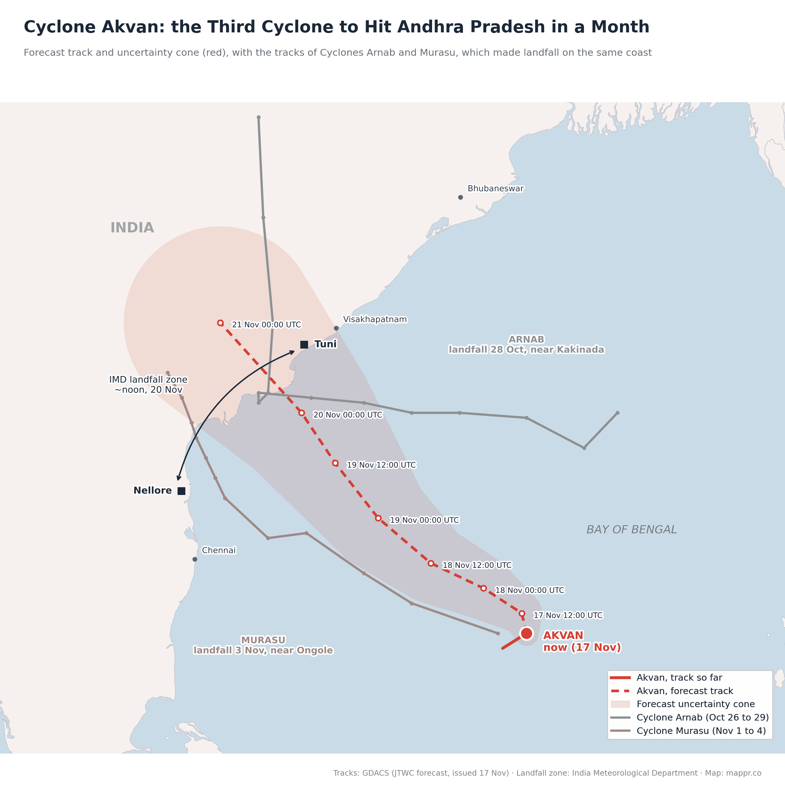
If the forecast holds, Akvan will be the third cyclone to strike Andhra Pradesh in about four weeks. Cyclone Arnab came ashore near Kakinada on 28 October, killing seven people and causing an estimated Rs 4,600 crore in losses. Less than a week later, Cyclone Murasu crossed the coast near Ongole on 3 November, killing eight and damaging crops on more than 140,000 hectares.
Akvan’s forecast landfall zone covers almost the whole stretch between those two hits. Fields still waterlogged from earlier storms, damaged embankments and stretched relief teams leave the coast more vulnerable than a single storm would on its own.
Why the Bay of Bengal Breeds Cyclones in November
India has two cyclone seasons. The first runs from April to June; the second, the post-monsoon season from October to December, produces some of the strongest storms. As the southwest monsoon retreats, the Bay of Bengal’s waters stay very warm, wind shear drops, and low-pressure systems drift in from the east, sometimes from the remnants of Pacific typhoons.
The Bay of Bengal is a far more active cyclone basin than the Arabian Sea on India’s west coast, and its shallow, funnel-shaped northern end makes storm surges especially dangerous for low-lying coasts in Andhra Pradesh, Odisha, West Bengal and Bangladesh. Better forecasting and mass evacuations have cut the death toll from cyclones dramatically in recent decades, but repeated hits like this autumn’s still cost lives, homes and harvests.
What to Expect
Heavy to very heavy rain is forecast across coastal Andhra Pradesh on 19 and 20 November, with isolated extremely heavy falls, and the IMD has also warned of heavy rain in Odisha and Chhattisgarh. Fishermen along the coast have been advised not to go to sea, and authorities are preparing evacuations and relief camps in low-lying areas.
We will update this page as Akvan approaches the coast, with the landfall details and any reported damage.