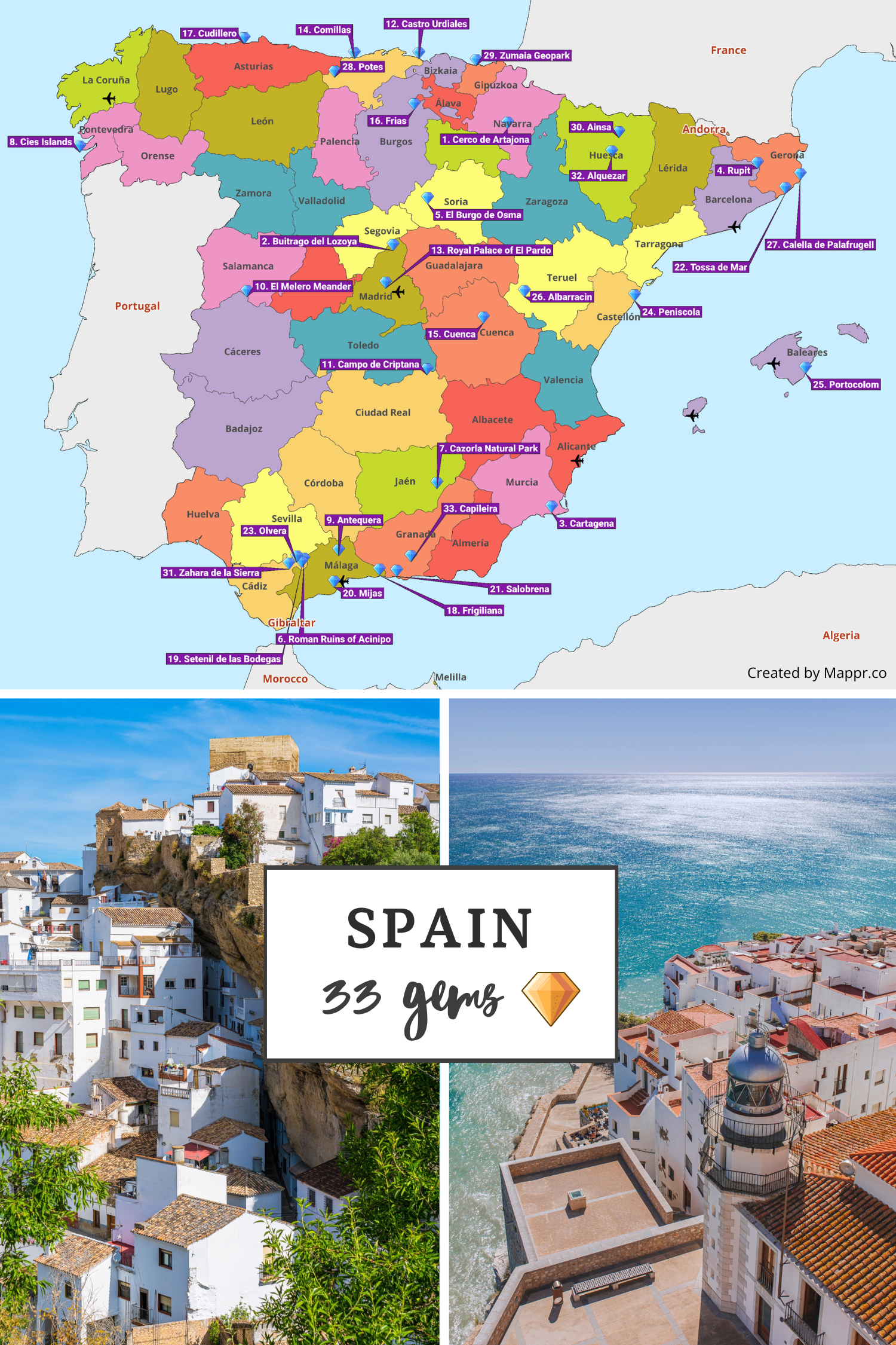
Embark on a summer adventure through Spain’s lesser-known marvels, from the medieval enchantment of Cerco de Artajona to the pristine beauty of the Cies Islands. This guide is your gateway to 33 hidden treasures scattered across the country, offering unique experiences far removed from the typical tourist trail.
Explore tranquil villages, historic ruins, lush natural parks, and breathtaking coastal spots. Each destination promises a glimpse into Spain’s rich cultural tapestry, vibrant history, and stunning natural landscapes. Whether it’s the timeless allure of Rupit, the ancient whispers of Acinipo, or the tranquil waters of Tossa de Mar, Spain’s hidden gems await to transform your summer into an unforgettable journey of discovery.
Dive into the heart of Spain this summer and let these hidden gems reveal the country’s true beauty, one extraordinary spot at a time.
| No. | Location | Region | Nearest Airport |
|---|---|---|---|
| 1 | Cerco de Artajona | Navarre | Pamplona Airport |
| 2 | Buitrago del Lozoya | Community of Madrid | Madrid-Barajas Adolfo Suárez Airport |
| 3 | Cartagena | Murcia | Alicante-Elche Airport |
| 4 | Rupit | Catalonia | Barcelona-El Prat Airport |
| 5 | El Burgo de Osma | Castile and León | Madrid-Barajas Adolfo Suárez Airport |
| 6 | Acinipo | Andalusia | Málaga Airport |
| 7 | Cazorla Natural Park | Andalusia | Granada Airport |
| 8 | Cies Islands | Galicia | Vigo-Peinador Airport |
| 9 | Antequera | Andalusia | Málaga Airport |
| 10 | El Melero Meander | Extremadura | Madrid-Barajas Adolfo Suárez Airport |
| 11 | Campo de Criptana | Castilla-La Mancha | Madrid-Barajas Adolfo Suárez Airport |
| 12 | Castro Urdiales | Cantabria | Bilbao Airport |
| 13 | Royal Palace of El Pardo | Madrid | Madrid-Barajas Adolfo Suárez Airport |
| 14 | Comillas | Cantabria | Santander Airport |
| 15 | Cuenca | Castilla-La Mancha | Madrid-Barajas Adolfo Suárez Airport |
| 16 | Frias | Castile and León | Bilbao Airport |
| 17 | Cudillero | Asturias | Asturias Airport |
| 18 | Frigiliana | Andalusia | Málaga Airport |
| 19 | Setenil de las Bodegas | Andalusia | Málaga Airport |
| 20 | Mijas | Andalusia | Málaga Airport |
| 21 | Salobreña | Andalusia | Granada Airport |
| 22 | Tossa de Mar | Catalonia | Girona-Costa Brava Airport |
| 23 | Olvera | Andalusia | Seville Airport |
| 24 | Peñíscola | Valencia | Castellón Airport |
| 25 | Portocolom | Balearic Islands | Palma de Mallorca Airport |
| 26 | Albarracín | Aragon | Valencia Airport |
| 27 | Calella de Palafrugell | Catalonia | Girona-Costa Brava Airport |
| 28 | Potes | Cantabria | Santander Airport |
| 29 | Zumaia Geopark | Basque Country | San Sebastián Airport |
| 30 | Aínsa | Aragon | Zaragoza Airport |
| 31 | Zahara de la Sierra | Andalusia | Seville Airport |
| 32 | Alquézar | Aragon | Zaragoza Airport |
| 33 | Capileira | Andalusia | Granada Airport |
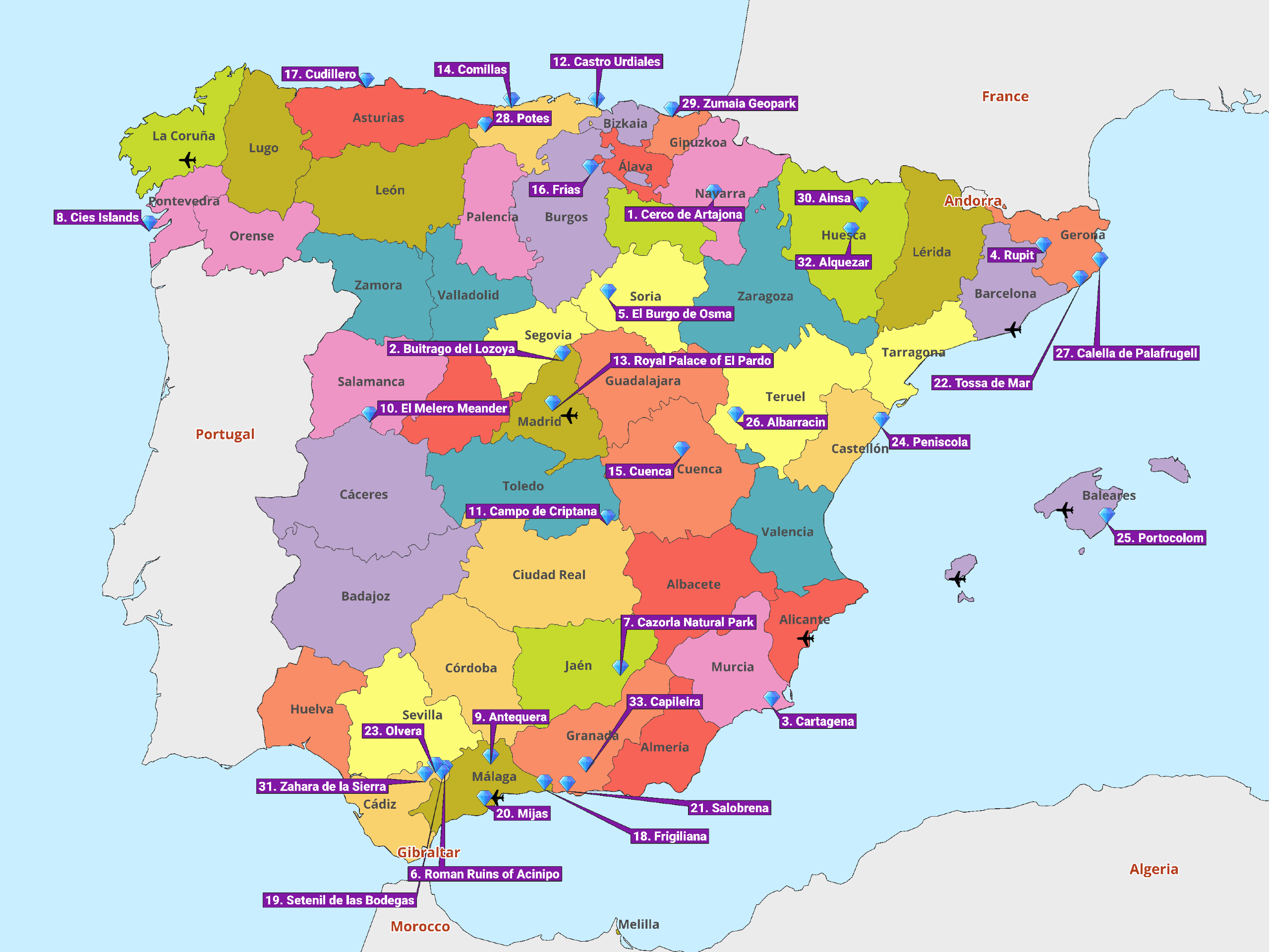
1. Cerco de Artajona

Cerco de Artajona is a captivating medieval fortress town that beckons visitors with its impressive walls and historical depth, offering a unique glimpse into Spain’s rich past.
With its ancient alleys and stunning architectural landmarks, this hidden gem is a perfect escape for those seeking tranquility and a touch of history under the warm summer sun.
Its strategic location on a hilltop provides breathtaking views of the surrounding countryside and a cooler, more comfortable climate during the hot summer months, making it an ideal destination for exploration and relaxation.
- ✈️ How to Get There: Easily accessible from Pamplona, just a 30-minute drive away, Cerco de Artajona is well-positioned for visitors coming from both domestic and international locations. The nearest airport in Pamplona offers convenient connections to major cities across Spain and Europe.
- 🏨 Where to Stay: The Hotel Rural el Castillo offers guests a comfortable stay with a touch of historical ambiance right at the heart of Artajona, while the Villa de Larraga provides an elegant retreat in a beautifully restored setting.
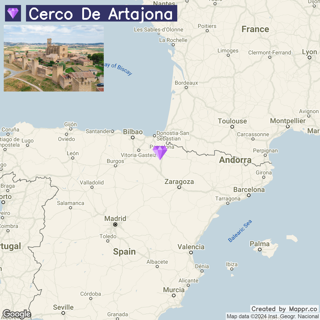
2. Buitrago del Lozoya

Nestled within a scenic bend of the Lozoya River, Buitrago del Lozoya offers a serene escape into Spain’s rich history and natural beauty.
Well-preserved Moorish walls encircle this enchanting town, and its castle, the Picasso Museum, and the 14th-century Church of Santa Maria del Castillo are testaments to its diverse cultural heritage.
The summer months bring this hidden gem to life, with lush landscapes and the river providing a cool respite from the Spanish sun.
- ✈️ How to Get There: Buitrago del Lozoya is conveniently located less than an hour from Madrid, the capital of Spain, making it an easy day trip for visitors. The nearest major airport is Madrid-Barajas Adolfo Suárez Airport, where you can rent a car or take a bus directly to the town.
- 🏨 Where to Stay: Hotel La Beltraneja boasts a medieval-themed décor and an intimate setting. Alojamientos Estrella Rural provides elegant rooms with panoramic views of the surrounding mountains for a more luxurious stay.
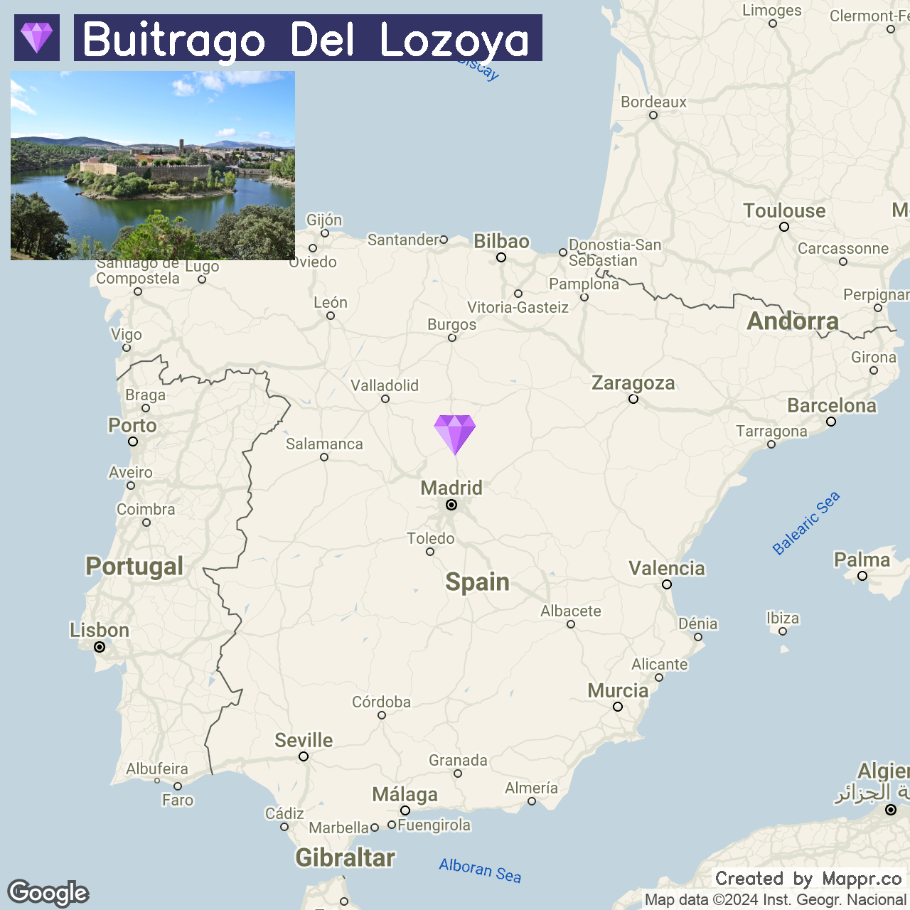
3. Cartagena

Cartagena is a port city on Spain’s southeastern coast known for its rich history dating back to Roman times, as illustrated by its well-preserved Roman Theatre.
The city’s blend of ancient ruins, Baroque architecture, and stunning natural harbors make it a captivating destination. In summer, the Mediterranean climate offers warm, sunny days ideal for exploring the city’s historic sites and enjoying its vibrant outdoor cafes and restaurants.
- ✈️ How to Get There: Cartagena is easily accessible from the Alicante-Elche Airport, about an hour’s drive away. Many international flights serve Alicante, making Cartagena a convenient destination.
- 🏨 Where to Stay: Hotel Cartagena Puerto is a comfortable option near the historic center, ideal for cultural exploration. Sercotel Alfonso XIII provides luxurious accommodations with modern amenities for a relaxing stay.
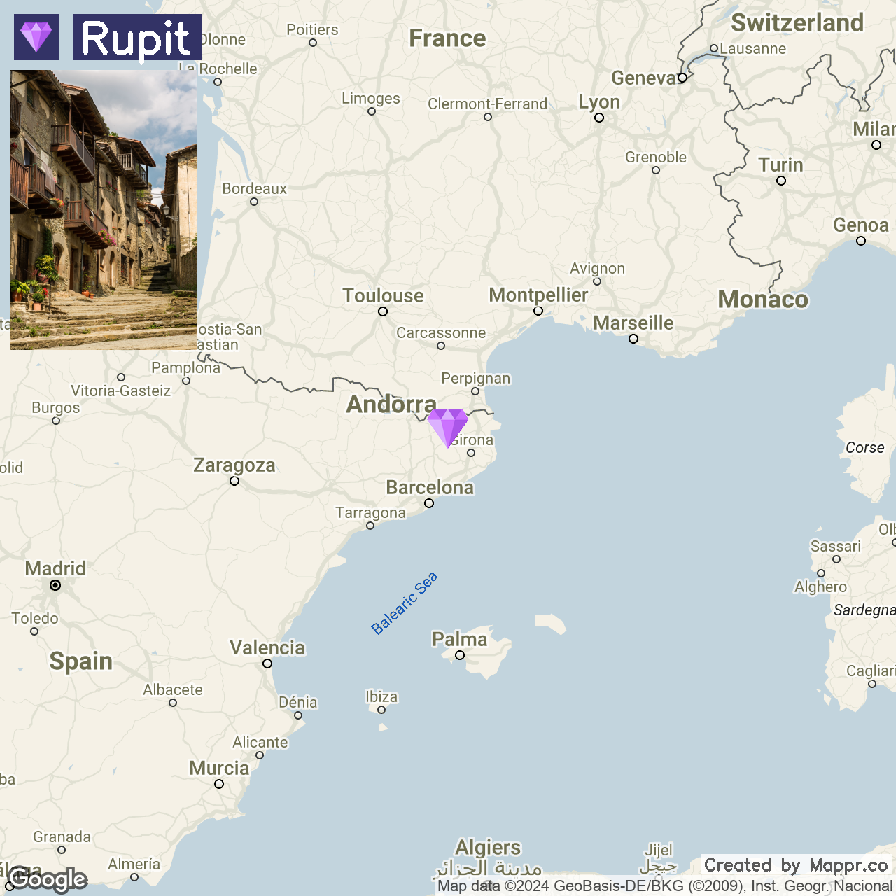
4. Rupit

Rupit is a quintessential Catalan village with cobblestone streets, rustic stone houses, and a picturesque hanging wooden bridge.
Nestled in the Collsacabra mountain range, its charm is magnified in summer when the surrounding forests and cliffs offer a verdant backdrop to the medieval architecture.
Rupit is an ideal destination for those looking to step back in time while enjoying the natural beauty of Catalonia.
- ✈️ How to Get There: The closest major city to Rupit is Barcelona, approximately a 1.5-hour drive away. Barcelona’s El Prat Airport serves as a major international gateway, making Rupit accessible to visitors from around the globe.
- 🏨 Where to Stay: Hostal Estrella offers a quaint, rustic experience with stunning views of the village and mountains. On the other hand, Mas La Serra is a countryside retreat near Rupit, offering a peaceful stay amidst nature.
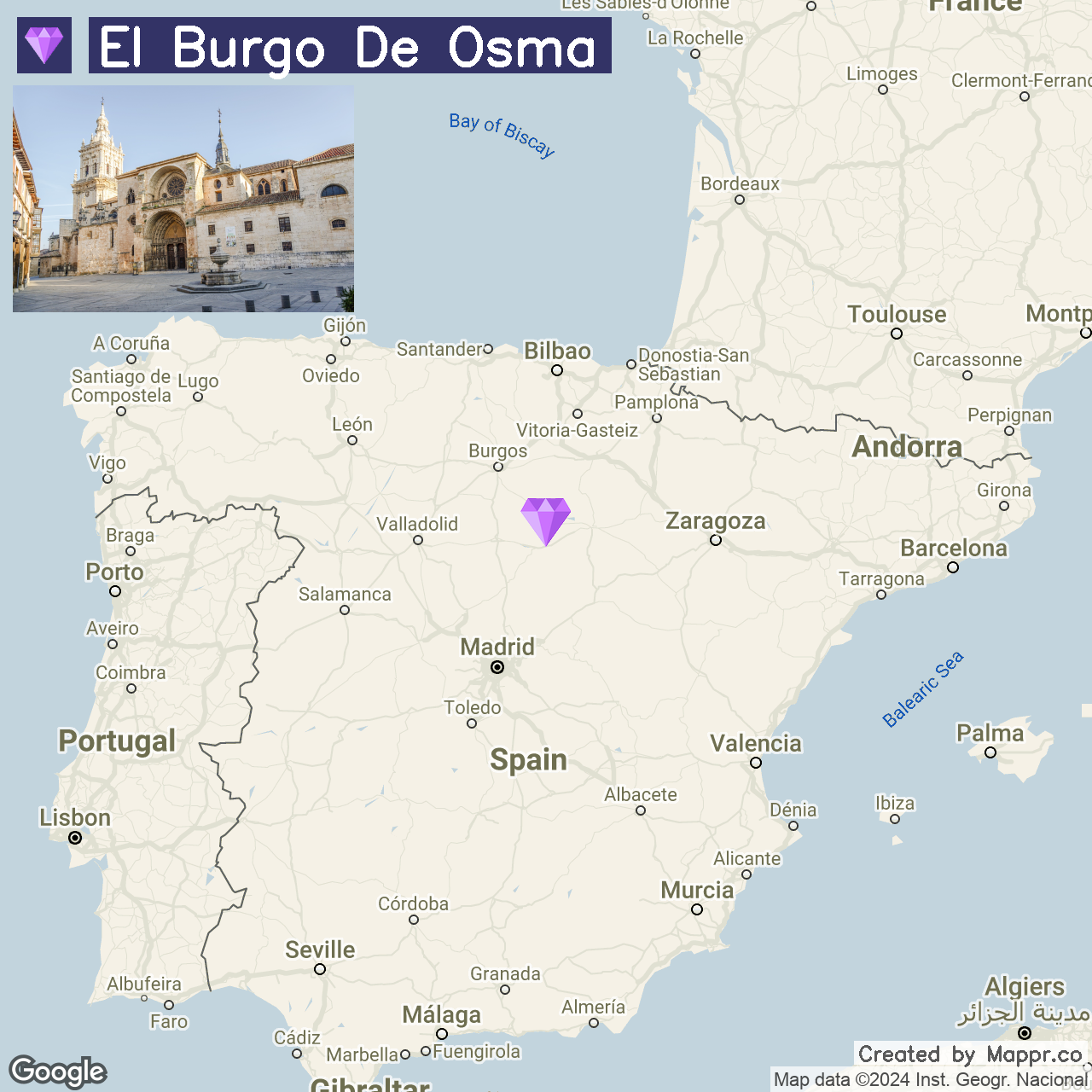
5. El Burgo de Osma

El Burgo de Osma is a historic treasure, with its medieval walls, Gothic cathedral, and the ancient Mapamundi. The town’s atmospheric Plaza Mayor is perfect for people-watching and soaking up the local culture.
In summer, El Burgo de Osma’s mild climate and the nearby Rio Lobos Canyon make it an ideal spot for outdoor enthusiasts exploring Spain’s natural beauty.
- ✈️ How to Get There: Located about a 2.5-hour drive from Madrid, El Burgo de Osma is best reached by car. The nearest airport is Madrid-Barajas, with regular rental services for a scenic drive through the Spanish countryside.
- 🏨 Where to Stay: Castilla Termal Burgo de Osma occupies a beautifully renovated Renaissance building, offering luxurious spa treatments and historical ambiance. Hotel II Virrey presents an elegant option with spacious rooms in the town center.
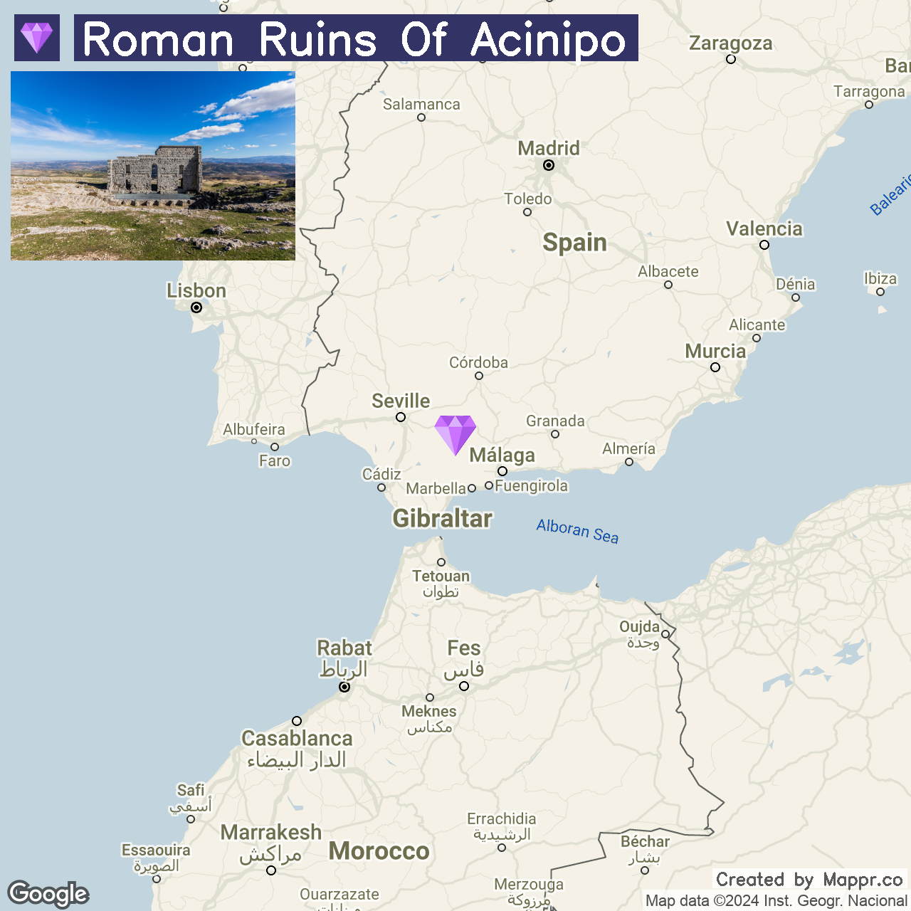
6. Roman Ruins of Acinipo

The Roman Ruins of Acinipo, perched high on a plateau with commanding views of the Andalusian countryside, are a window into ancient history.
Known locally as “Ronda la Vieja,” this archaeological site was once a bustling Roman city. The standout feature is its remarkably well-preserved Roman theater, which still hosts performances.
The summer offers the perfect climate for exploring these ruins, with the bonus of witnessing the surrounding landscapes in full bloom.
- ✈️ How to Get There: Acinipo is best accessed from Ronda, approximately a 20-minute drive from Acinipo. It is well-connected by rail and road to major Andalusian cities like Seville and Málaga.
- 🏨 Where to Stay: In Ronda, Hotel Catalonia Reina Victoria overlooks the scenic Tajo Gorge, offering comfort and elegance. Alternatively, Parador de Ronda is an excellent place on the edge of the famous Puente Nuevo, providing guests with breathtaking views.
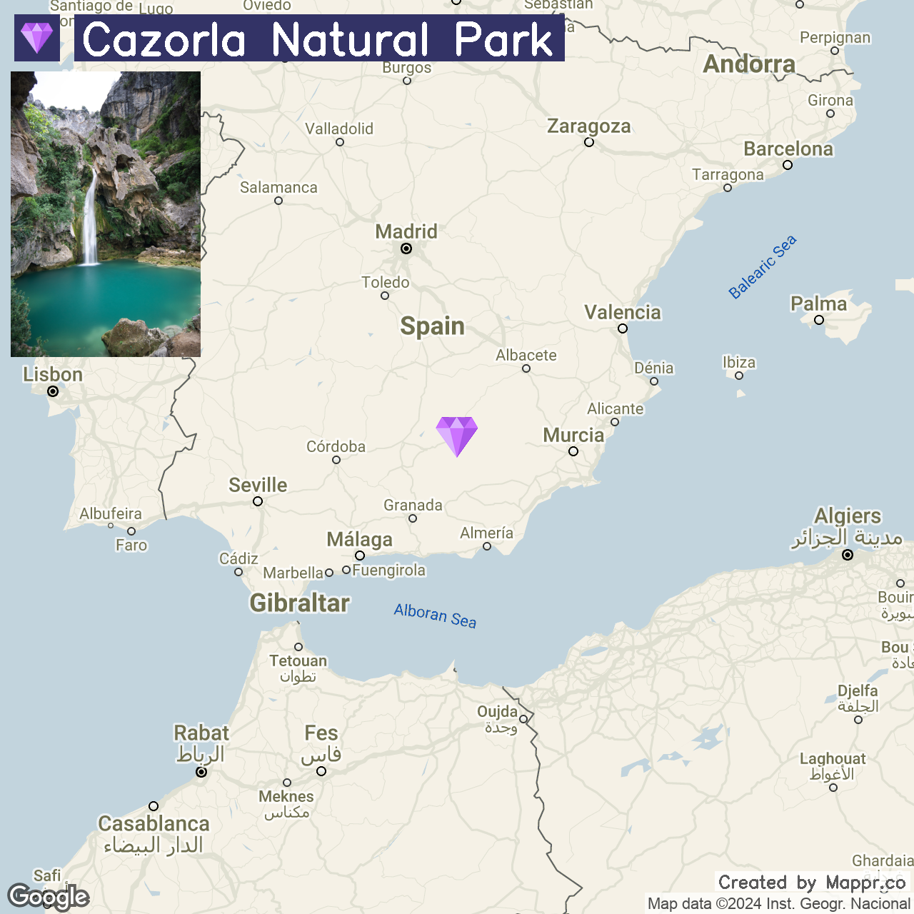
7. Cazorla Natural Park

Cazorla Natural Park, located in the province of Jaén, is a vast expanse of protected land that is part of the Sierras de Cazorla, Segura, and Las Villas Natural Park.
It is renowned for its lush forests, dramatic waterfalls, and diverse wildlife. In the summer, the park’s higher altitude provides a cooler alternative to Spain’s intense heat, allowing visitors to explore its natural beauty comfortably.
The park’s numerous trails and the stunning Guadalquivir River that originates within its boundaries create a perfect setting for hiking, bird watching, and photography.
- ✈️ How to Get There: The natural park is most accessible from the cities of Jaén or Granada. Jaén is approximately a 2-hour drive from the park, while Granada is about 3 hours away.
- 🏨 Where to Stay: Parador de Cazorla is located within the park, offering guests a serene mountain retreat with traditional Andalusian architecture. Hotel Sierra de Cazorla & Spa provides a comfortable base for exploring the park, with spa facilities to relax after hiking.
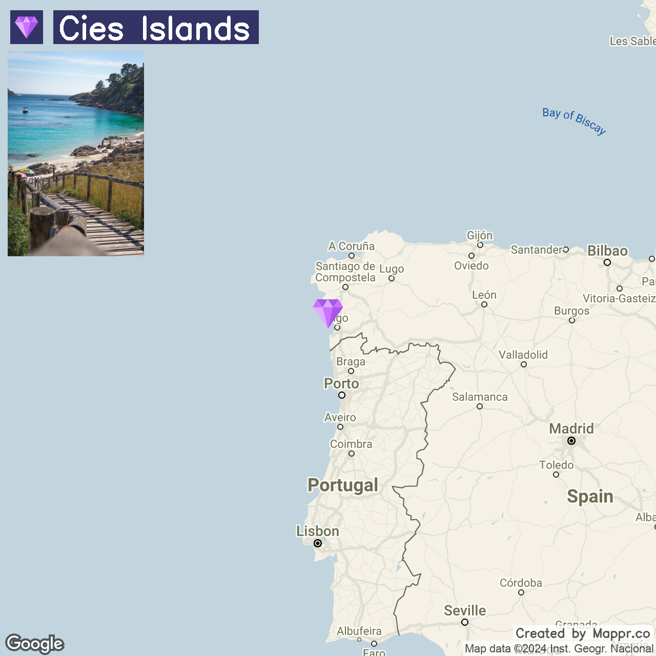
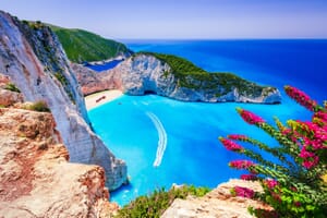
8. Cies Islands

The Cies Islands are a trio of pristine islands off the coast of Galicia, known for their crystal-clear waters, fine white sand beaches, and unspoiled natural landscapes.
These islands, part of the Atlantic Islands of Galicia National Park, are especially enchanting in the summer when the weather is ideal for beach activities, hiking, and bird-watching.
The islands’ most famous beach, Playa de Rodas, often ranks among the world’s best beaches for its natural beauty and tranquil waters.
- ✈️ How to Get There: The Cies Islands are accessible by ferry from Vigo, the closest major urban center. Vigo has an international airport, Vigo-Peinador Airport, with flights to major Spanish cities and some international destinations.
- 🏨 Where to Stay: Gran Hotel Nagari Boutique & Spa offers luxurious lodgings and a rooftop pool with panoramic city views. Another great option is Hotel Ciudad de Vigo, which provides spacious rooms with seafront views and is close to the ferry terminal.
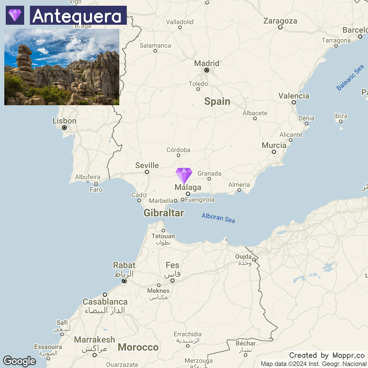
9. Antequera

Antequera, known as the “heart of Andalusia,” is a blend of natural beauty and historical sites, including the Alcazaba and the Antequera Dolmens Site.
The town’s summer allure is enhanced by its lively squares, local cuisine, and the nearby El Torcal Nature Reserve, offering a picturesque landscape of limestone formations.
- ✈️ How to Get There: Antequera is easily accessible by a 45-minute drive from Málaga, which has an international airport serving numerous global destinations. The town can also be reached by high-speed train.
- 🏨 Where to Stay: Parador de Antequera offers modern luxury with spacious gardens and stunning views of the Andalusian landscape. Hotel Finca Eslava is a charming rural hotel on the outskirts of Antequera, featuring traditional Andalusian architecture.
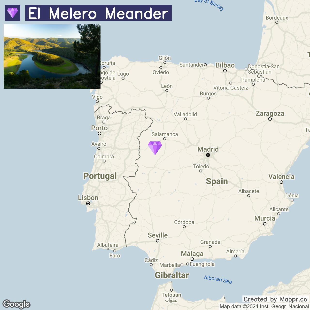
10. El Melero Meander

El Melero Meander, a spectacular horseshoe bend carved by the Alagón River, is a natural masterpiece in the heart of Extremadura.
This breathtaking geological formation is best viewed from the Mirador de La Antigua, where the river’s emerald waters contrast sharply with the golden hues of the surrounding Spanish countryside.
Visiting in summer allows for the lush vegetation to be fully appreciated, making for stunning photographs and serene moments of contemplation.
- ✈️ How to Get There: The nearest central town to El Melero Meander is Plasencia, accessible by car in about an hour. Plasencia is connected by train and bus to Madrid, the closest international airport. Renting a car from Madrid or Plasencia is recommended to explore the region fully.
- 🏨 Where to Stay: Parador de Plasencia is a luxurious option in a converted 15th-century monastery. Alternatively, Hotel Exe Alfonso VIII offers modern accommodations in the heart of Plasencia.
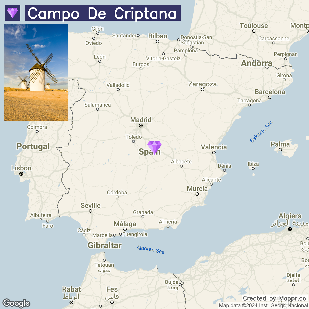
11. Campo de Criptana

Campo de Criptana is a picturesque village in the heart of La Mancha, famous for its iconic windmills that are said to have inspired Miguel de Cervantes’ “Don Quixote.”
These historic windmills, perched atop the Cerro de la Paz, offer panoramic views of the surrounding plains. Visiting during the summer allows for spectacular sunsets and the chance to experience local festivals that bring the town’s rich cultural heritage to life.
- ✈️ How to Get There: Campo de Criptana is easily accessible from Madrid, about a 2-hour drive away. The nearest major airport is Madrid-Barajas Adolfo Suárez Airport, offering a wide range of international and domestic flights.
- 🏨 Where to Stay: Hotel Rural La Vida de Antes in the nearby town of Consuegra features traditional La Mancha architecture with a modern touch. Intelier Airén Hotel provides comfortable and elegant lodgings in Alcázar de San Juan, a short distance from Campo de Criptana.
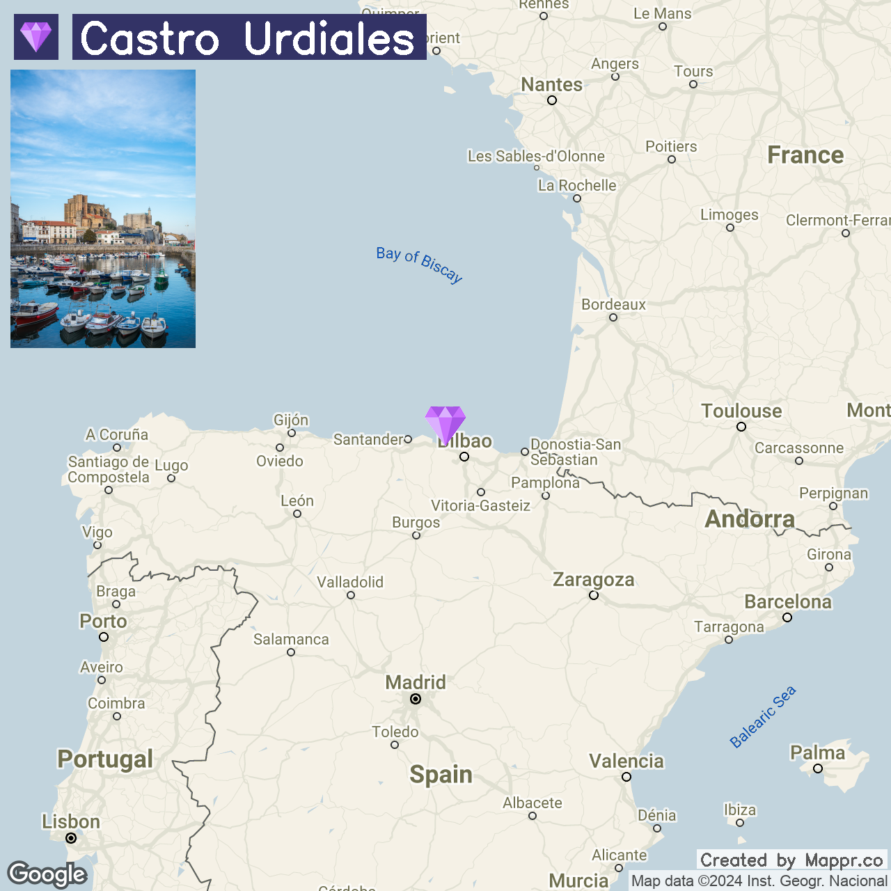
12. Castro Urdiales

Castro Urdiales is a charming coastal town in Cantabria, northern Spain, known for its beautiful beaches, medieval architecture, and the impressive Church of Santa María de la Asunción.
The town’s scenic harbor and vibrant summer festivals make it a lively destination for travelers seeking relaxation and cultural immersion.
- ✈️ How to Get There: The nearest airport is in Bilbao, about 30 minutes away by car. Bilbao is well-connected by flights from major European cities and offers a scenic drive along the coast to Castro Urdiales.
- 🏨 Where to Stay: Hotel Las Rocas Playa offers stunning sea views and spacious, comfortable rooms right on the beachfront. Alternatively, Pensión La Mar provides a cozy, family-run atmosphere in the heart of the town, close to local dining and beaches.
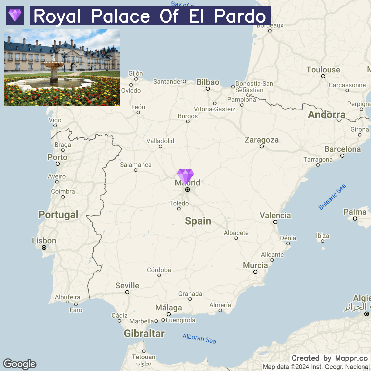
13. Royal Palace of El Pardo

The Royal Palace of El Pardo is a historic residence in the El Pardo district of Madrid, surrounded by lush forested areas.
Once a hunting lodge, it has served as a residence for Spanish monarchs and visiting dignitaries. The palace’s architecture and art collections, along with the tranquil El Pardo Monte, make it a fascinating destination for those interested in history and nature.
The summer months offer a perfect opportunity to explore the palace’s opulent interiors and the surrounding natural landscapes, providing a cooler escape from Madrid’s urban heat.
- ✈️ How to Get There: The Royal Palace of El Pardo is just a short distance from the center of Madrid, making it easily accessible by car, bus, or taxi.
- 🏨 Where to Stay: For visitors looking to stay near the Royal Palace of El Pardo, Eurostars Zarzuela Park offers a peaceful setting with comfortable rooms and a seasonal outdoor pool. Alternatively, Hotel Eurostars Monte Real features elegant rooms and a beautiful garden, and it is located in a quiet residential area.
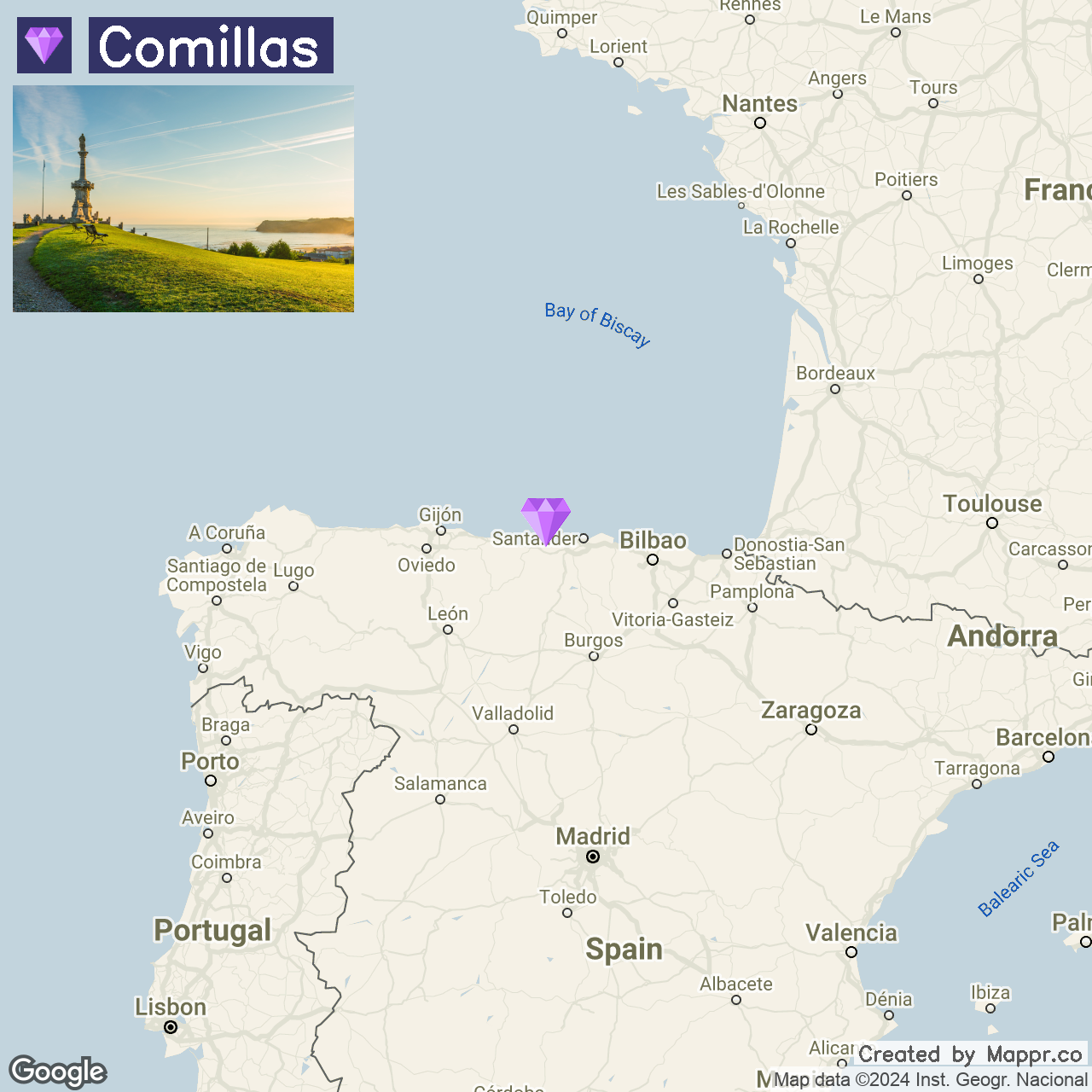
14. Comillas

Comillas is a coastal gem known for its significant Art Nouveau architecture and the legacy of Antoni Gaudí. This town stands out for its cobbled streets, open squares, and remarkable buildings, including the famous El Capricho, a Gaudí masterpiece.
The town’s architectural distinction is attributed to the influence of emigrants returning from America, who introduced Catalan Modernism to the area.
Comillas is not just about architecture; it also offers beautiful sandy beaches and the Oyambre Nature Reserve, providing a perfect blend of cultural heritage and natural beauty.
- ✈️ How to Get There: The town is approximately 50 km west of Santander, making it easily accessible for visitors traveling through this regional capital.
- 🏨 Where to Stay: For those wishing to immerse themselves in the grandeur of Comillas’ past, Hotel Comillas offers a blend of classic elegance and modern amenities. Apartamentos Villa Sofia provides exceptional golfing facilities and stunning views for a more luxurious stay.
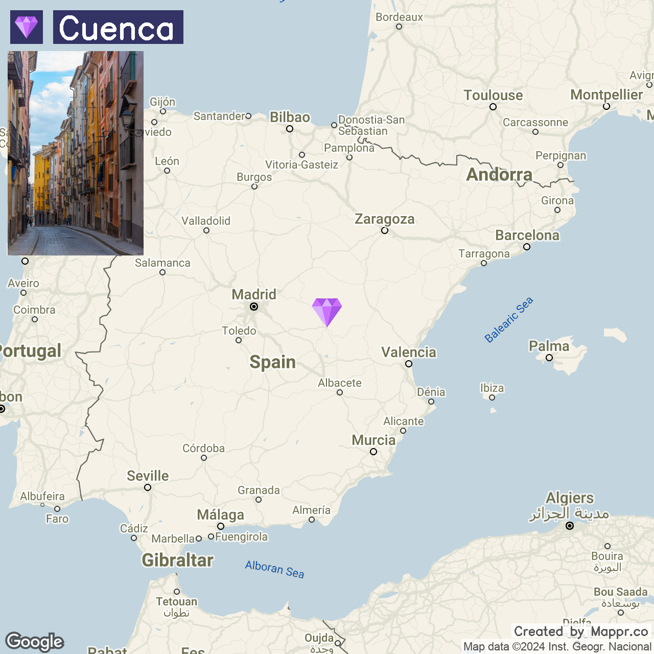
15. Cuenca

Cuenca is a beacon of medieval architecture and natural beauty, perched above the gorges of Spain’s Júcar and Huécar rivers.
Summer in Cuenca is a vibrant season, perfect for exploring its historic streets, enjoying the cooler climate, and delving into the city’s rich tapestry of festivals and art.
The city invites adventurers and culture enthusiasts with its Gothic Cuenca Cathedral, contemporary Museo de Arte Abstracto Español, and the mesmerizing landscapes of the surrounding countryside, including the Ciudad Encantada with its naturally sculpted rocks.
- ✈️ How to Get There: Cuenca is conveniently reached from Madrid, with high-speed trains connecting the two cities in about an hour. Madrid-Barajas Adolfo Suárez Airport is the nearest primary international gateway.
- 🏨 Where to Stay: Immerse yourself in history at the Parador de Cuenca, enjoy the blend of heritage and comfort at the Hotel Convento del Giraldo, or opt for the contemporary ease of the NH Ciudad de Cuenca, each offering a unique perspective of the city’s beauty and charm.
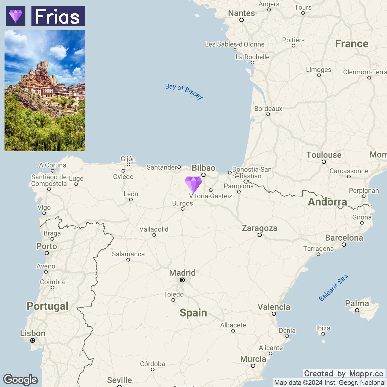
16. Frias

Frias is a testament to the enduring charm of medieval Spain, crowned by its commanding castle and surrounded by the picturesque Ebro River.
This quaint town, one of the smallest cities in Spain, captivates visitors with its ancient stone bridge, historic streets, and houses that seem to cling precariously to the rocky hillside.
Frias comes alive in summer with its floral-adorned balconies, offering a serene escape into a past where time moves leisurely, and its strategic position atop a hill provides panoramic views of the surrounding landscapes.
- ✈️ How to Get There: The journey to Frias begins in Bilbao, the nearest major city with an international airport. From Bilbao, a drive of approximately 1.5 hours through the Basque countryside will lead you to this hidden gem.
- 🏨 Where to Stay: In Frias, Casa Rural La Poza de la Torca I y II offers a cozy retreat, blending rustic allure with the comfort of home. For a unique blend of spirituality and comfort, El Priorato de Trespaderne invites guests into a space where history and tranquility converge.
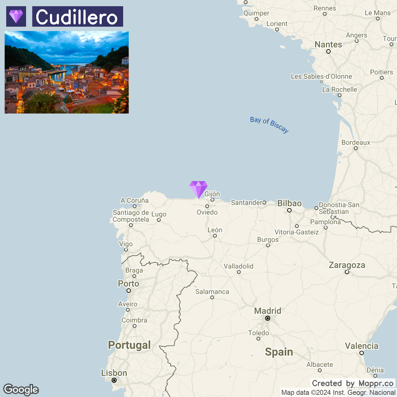
17. Cudillero

Cudillero, a picturesque village in Northern Spain, is renowned for its colorful houses cascading down to the harbor, creating a stunning visual that captivates all who visit.
With its quaint streets and idyllic coastal setting, this charming fishing village offers serene beauty and cultural richness.
The village’s unique charm is further enhanced by its historical significance on the Northern Way of the Camino de Santiago, drawing pilgrims and tourists to its scenic vistas and welcoming atmosphere.
For those seeking breathtaking views, a trek to the top of the village is a must, where the panoramic scenery of Cudillero and the Asturian coastline unfolds.
- ✈️ How to Get There: Cudillero is most conveniently visited from nearby Asturian cities such as Gijón or Oviedo, with regular train connections making the village accessible for a day trip or a longer stay.
- 🏨 Where to Stay: La Casona de Pío offers a cozy stay in a building with historical significance, once a fish-salting factory, now providing a lodging experience. For a touch of elegance, Casona de la Paca, set in a beautifully restored manor just outside the village, offers plush accommodations amidst extensive grounds.
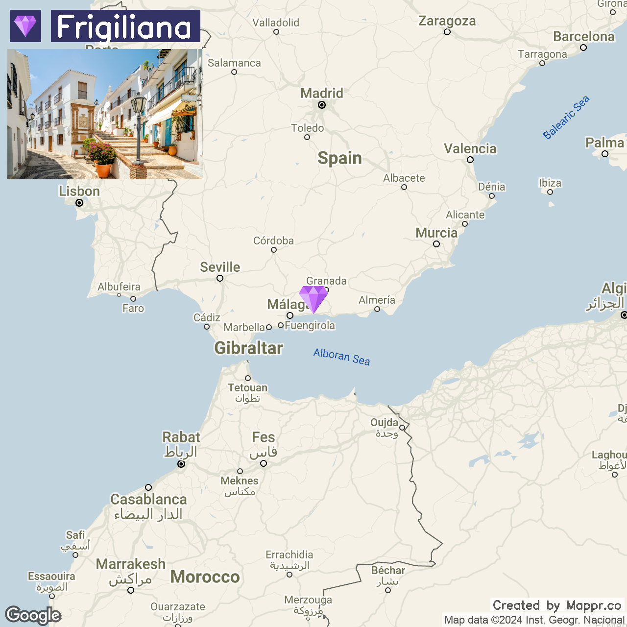
18. Frigiliana

Frigiliana, nestled in the hills just north of Malaga, is often hailed as one of the most beautiful villages in Spain.
Its whitewashed houses, adorned with vibrant flowers and cobblestone streets, cascade down the hillside, offering breathtaking views of the Mediterranean and the surrounding Sierras.
Summer in Frigiliana is a delightful experience, with the village’s Moorish past reflected in its architecture and the annual Festival of Three Cultures celebrating its diverse heritage.
- ✈️ How to Get There: Frigiliana is easily accessible from Malaga, with a short drive of about 50 minutes along the coast and inland. Malaga’s international airport is a convenient gateway for travelers looking to uncover this treasure.
- 🏨 Where to Stay: In Frigiliana, the Hotel Villa Frigiliana offers guests a charming base with stunning views of the village and the Mediterranean. For a more secluded experience, the Hotel La Casa provides a cozy retreat amidst the beauty of nature.
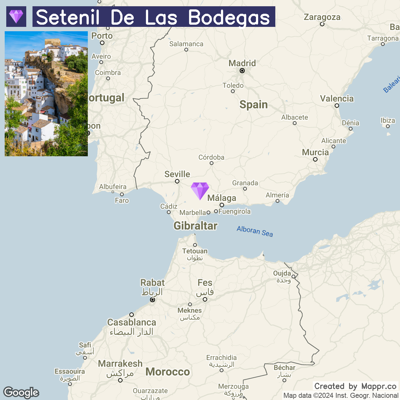
19. Setenil de las Bodegas

Setenil de las Bodegas is not just a town; it’s a marvel of human adaptability, built into the cliffs that shelter it.
This unique village in Andalusia is famed for its houses, constructed ingeniously under overhanging rocks, creating a mesmerizing streetscape that blends seamlessly with the natural environment.
Summers in Setenil offer a chance to wander its shaded streets, discover its rich gastronomy centered around local products like olive oil, honey, and chorizo, and experience the lively atmosphere of its bars and cafes nestled within the rock.
- ✈️ How to Get There: The nearest major city to Setenil de las Bodegas is Malaga, from where it can be reached in under 2 hours by car. Malaga’s international airport also provides a convenient entry point for travelers drawn to Setenil.
- 🏨 Where to Stay: In the heart of Setenil, the Tugasa Hotel Villa de Setenil offers a comfortable base with a traditional Andalusian feel. Casa Rural Las Bodegas presents a homely retreat with charming rooms and proximity to the iconic rock overhangs.
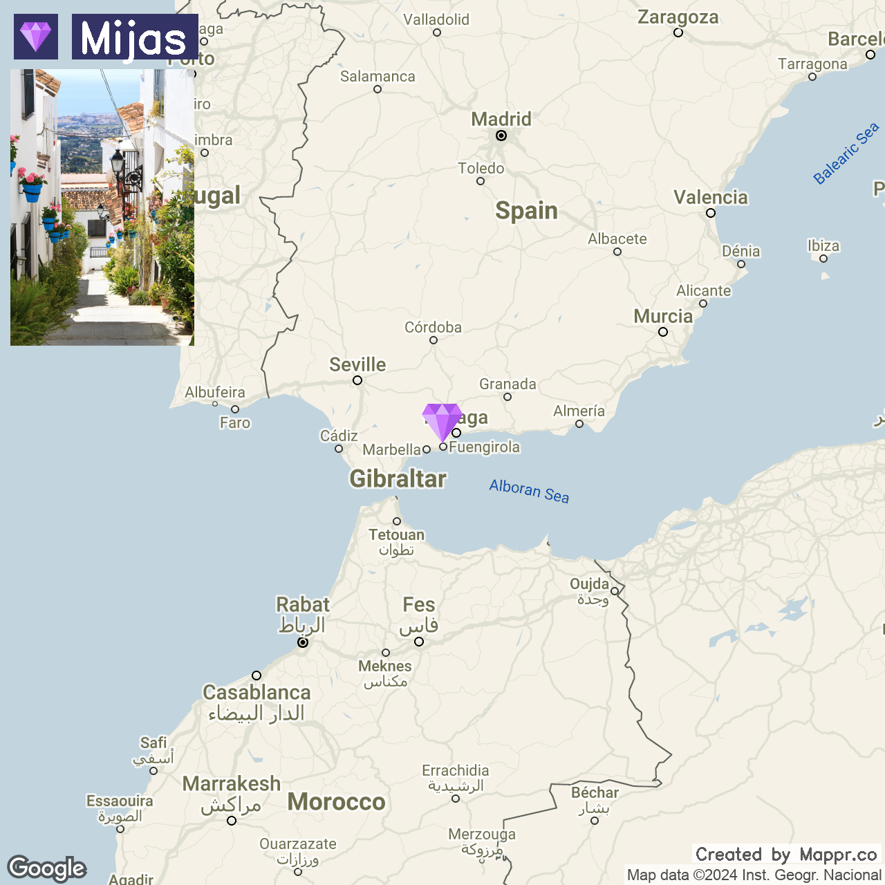
20. Mijas

Mijas is a gem tucked away in the Costa del Sol, known for its traditional Andalusian charm, whitewashed buildings, and panoramic views of the Mediterranean.
Mijas offers a tranquil retreat from the hustle and bustle of the coast, with its labyrinth of narrow streets, vibrant flower pots, and donkey taxis adding to its unique character.
Summers in Mijas offer an invitation to explore its historic sites, such as the centuries-old churches and the remnants of its Moorish past, while enjoying the modern amenities of its coastal counterpart.
The town is a haven for artists and craftsmen, with galleries and workshops dotting the streets, showcasing the region’s rich cultural heritage.
- ✈️ How to Get There: Mijas is easily accessible from Malaga, about a 30-minute away. Malaga’s international airport, a significant gateway to the Costa del Sol, makes Mijas an easily reachable destination for international and domestic visitors.
- 🏨 Where to Stay: In Mijas, La Cala Resort offers a serene escape with its spa facilities and breathtaking views of the Andalusian countryside. For a more intimate experience, the La Casa de la Iglesia, a traditional Andalusian guesthouse, provides a warm welcome with its beautifully decorated rooms.
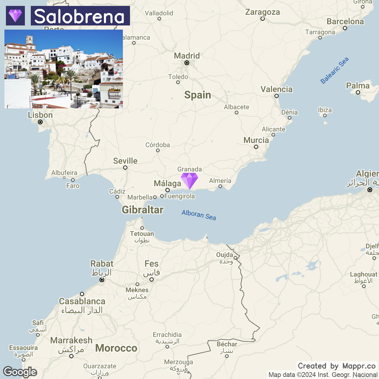
21. Salobreña

Salobreña graces the Costa Tropical of Granada with its whitewashed houses and ancient Moorish castle set against the backdrop of the azure Mediterranean and the rugged Sierra Nevada.
This picturesque town is a mosaic of history, culture, and natural beauty, where narrow winding streets lead to lush gardens, sunny plazas, and breathtaking viewpoints.
Summers in Salobreña blend of cultural festivities, beach relaxation, and exploration of its rich heritage, from the majestic hilltop castle to the vibrant fruit orchards in the surrounding valley.
- ✈️ How to Get There: Salobreña is best reached from Granada or Malaga. The drive from Granada takes about an hour, winding through the Andalusian countryside, while Malaga is approximately 1.5 hours away.
- 🏨 Where to Stay: The Hotel Miba offers a modern retreat with its sleek design, rooftop pool, and stunning views of Salobreña’s ancient castle and the sea. For those seeking a more traditional setting, the Hostal Palomares provides a cozy, family-run atmosphere with personalized service.
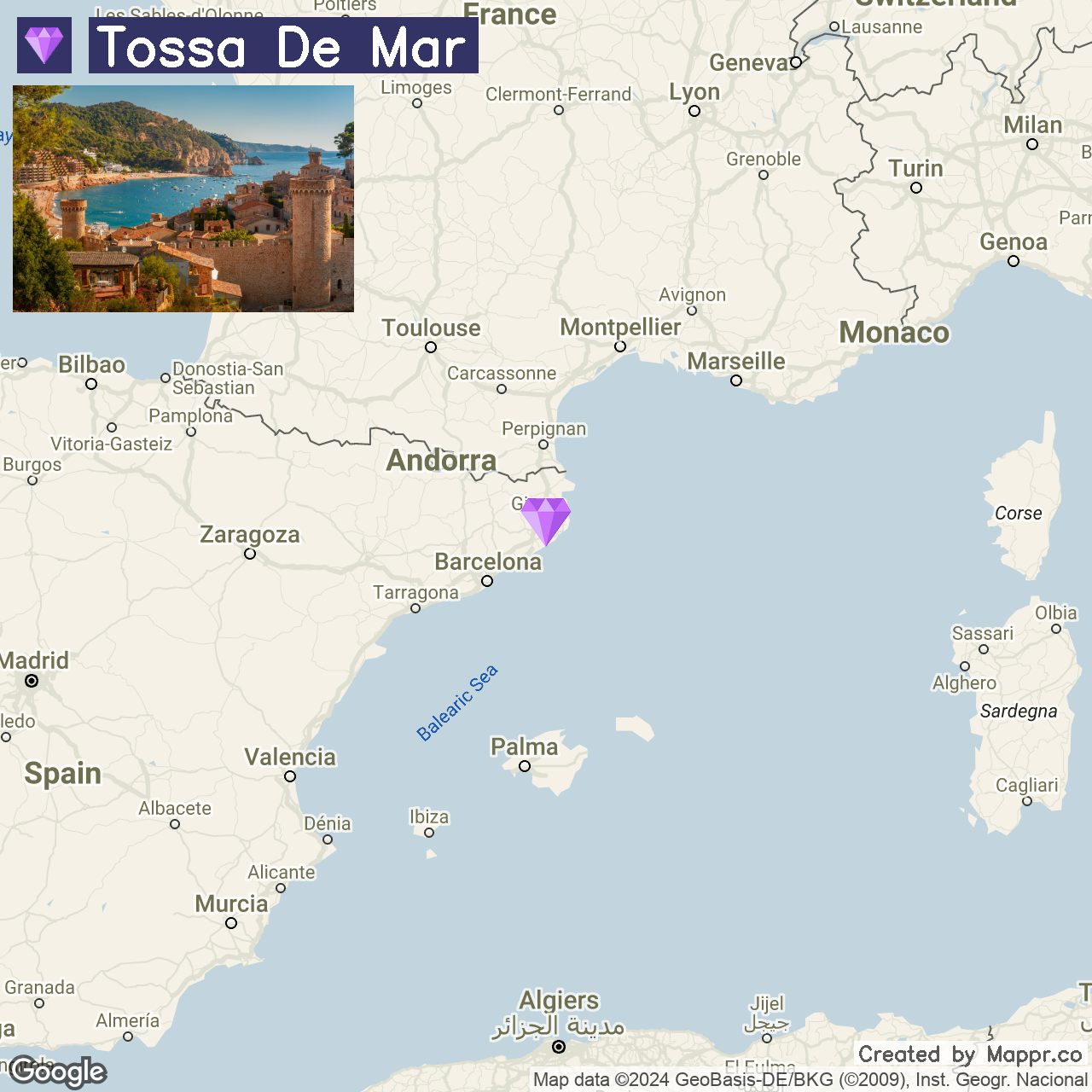
22. Tossa de Mar

Tossa de Mar is a coastal jewel on the rugged Costa Brava, renowned for its pristine beaches, crystal-clear waters, and the imposing medieval castle that stands guard over the town.
This picturesque setting is framed by the wild beauty of the surrounding landscapes, making Tossa de Mar a perfect synthesis of history, culture, and natural splendor.
Summers here are a time for strolls along the cobbled streets of the Vila Vella, sunbathing on the golden sands of Platja Gran, and diving into the Mediterranean’s azure depths.
- ✈️ How to Get There: Tossa de Mar is conveniently located just an hour’s drive from Barcelona, making it easily accessible for those arriving through Barcelona-El Prat Airport.
- 🏨 Where to Stay: The Gran Hotel Reymar & Spa offers an exquisite stay with its prime beachfront location, modern amenities, and stunning views. For a more secluded experience, the Hotel Diana, set in a beautiful modernist building in the heart of the town, provides a unique blend of history and comfort.
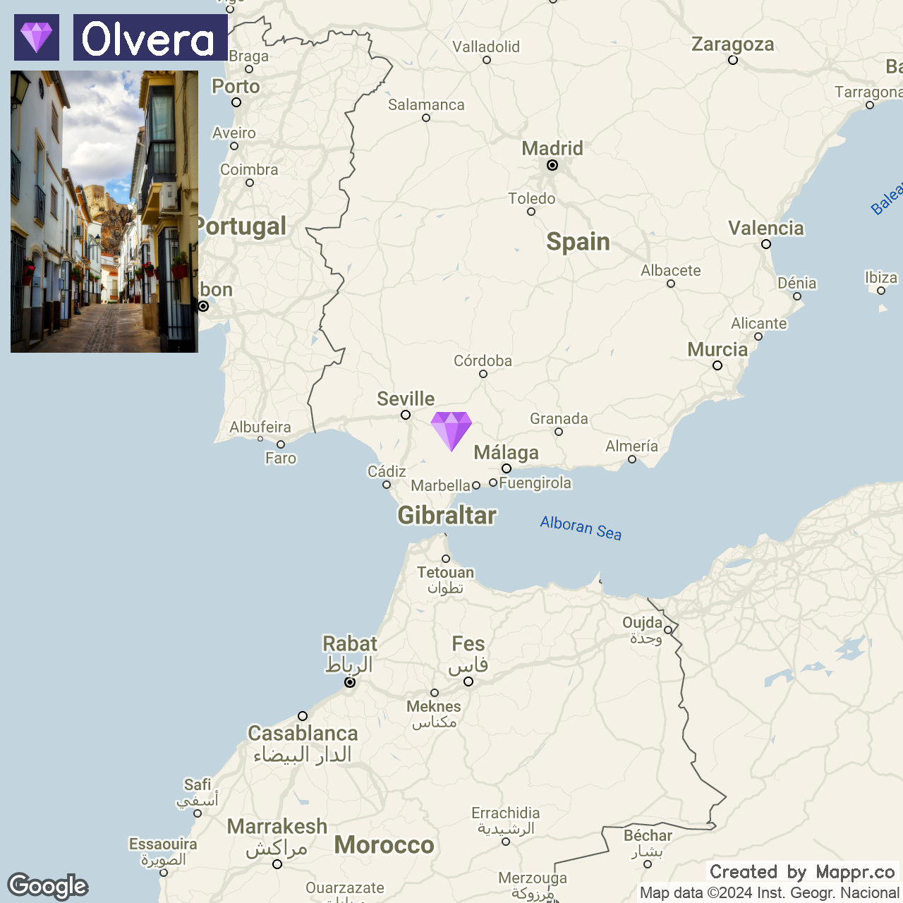
23. Olvera

Olvera is one of Andalusia’s most striking “pueblos blancos” (white towns), distinguished by its whitewashed houses and crowned by an imposing Moorish castle and a splendid neoclassical church.
Nestled amidst the rolling hills of the Sierra de Cádiz, Olvera is a snapshot of rural Spain, where traditions hold firm, the seasons dictate the pace of life, and summers are filled with the scent of olive groves and the sight of sun-drenched landscapes.
The town’s architectural beauty and serene surroundings make it a perfect retreat for those interested in Andalusia’s rural charm.
- ✈️ How to Get There: The nearest major airports to Olvera are Seville and Malaga, each about a 2-hour drive away. The journey through Andalusia offers scenic routes passing through olive groves and other landscapes.
- 🏨 Where to Stay: The Sierra y Cal offers a rustic retreat in the heart of Olvera, with its traditional charm and views of the castle and cathedral. Alternatively, Casa Vagón Vía Verde offers guests the chance to stay in a converted train carriage along the Via Verde.
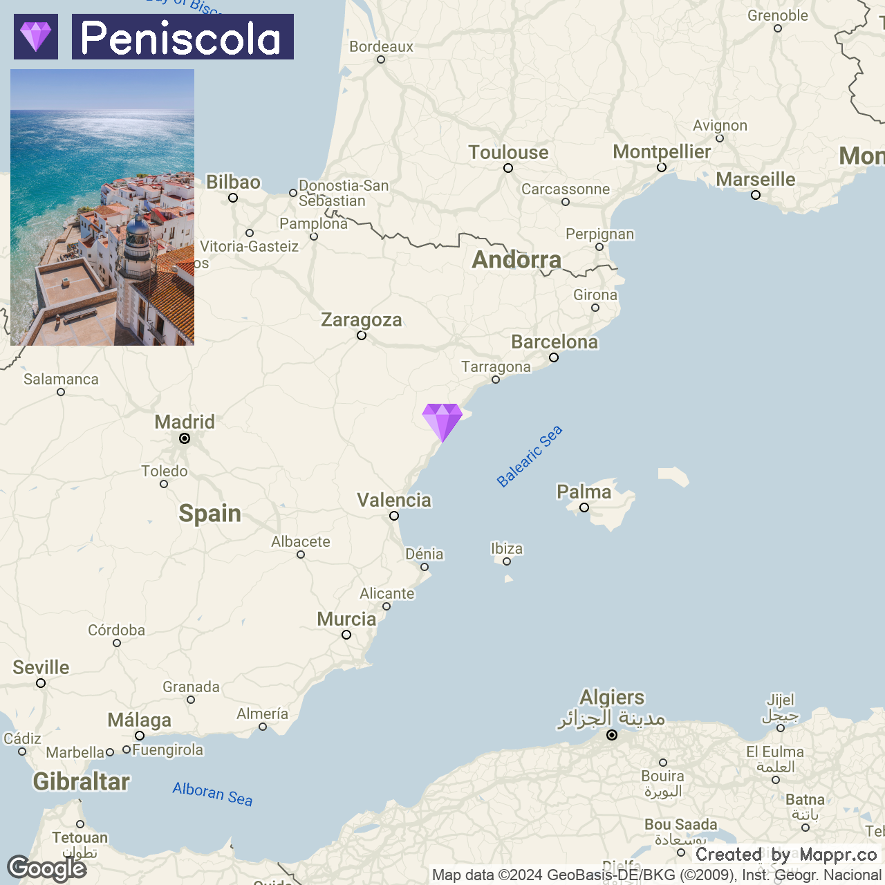
24. Peñíscola

Peñíscola, dubbed the “Gibraltar of Valencia,” marries historic grandeur with coastal charm, highlighted by its commanding Templar castle and picturesque beaches.
This town, perched on a rocky outcrop, is woven with narrow streets and white houses leading to the Mediterranean’s inviting waters. It’s a blend of history and leisure, ideal for summer visits.
The town buzzes with cultural events like film festivals and concerts during summer, enhancing its historic ambiance. Playa Norte and the surrounding Sierra de Irta Natural Park cater to beachgoers and outdoor enthusiasts alike.
- ✈️ How to Get There: Peñíscola is easily accessible from Valencia or Barcelona. The drive from Valencia takes about 1.5 hours, offering a scenic route along the coast, while Barcelona is approximately a 2.5-hour drive to the north.
- 🏨 Where to Stay: The Hotel RH Portocristo & Wellness stands out for its prime beachfront location and modern amenities. For a more intimate experience, The Aparthotel Acuazul, located on the beachfront, caters to families and couples alike with its spacious rooms, spa facilities, and entertainment options.
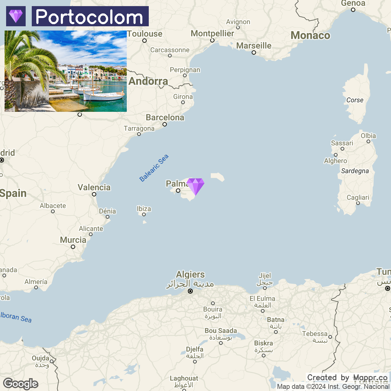
25. Portocolom

Portocolom offers a glimpse of authentic Mallorcan charm, with its natural harbor being one of the largest and most picturesque on the island.
This tranquil town, far removed from the bustling tourist spots, is a haven of peace with its pastel-colored fishermen’s houses, quaint lighthouse, and serene beaches like Cala Marçal.
The town’s historical significance, evidenced by nearby archaeological sites, adds layers to a visit here, blending leisure with a touch of history. For outdoor enthusiasts, the surrounding landscapes offer hiking and cycling routes that reveal the natural beauty of Mallorca.
- ✈️ How to Get There: Portocolom is best reached from Palma de Mallorca, with the journey taking just over an hour by car. Palma’s airport, the main gateway to the island, facilitates easy access to this serene coastal town.
- 🏨 Where to Stay: The Hotel Vistamar by Pierre & Vacances welcomes guests with its elegant rooms and panoramic harbor views. For a more intimate setting, the Barefoot Hotel presents a blend of comfort and relaxation, focusing on providing a tranquil experience for its guests.
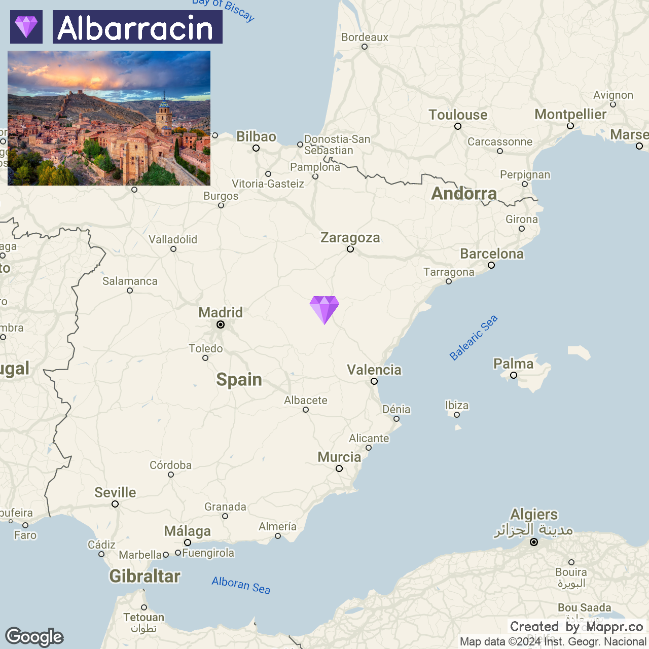
26. Albarracín

Albarracín, celebrated as one of Spain’s most picturesque villages, enchants with its medieval walls, serpentine streets, and rose-tinted houses.
Set in Teruel’s mountains, this town offers a journey through time, showcasing its Moorish and medieval roots. Perched by the Guadalaviar River, it provides breathtaking views and a refreshing summer haven.
The town’s historic fortress, cathedral, and unique architecture transport visitors to another era. The surrounding Sierra de Albarracín, with its abundant trails, is perfect for those keen on combining historical exploration with outdoor activities.
- ✈️ How to Get There: Albarracín is most easily reached from Zaragoza or Valencia, with both cities offering international airports. The drive from either city takes about 2 hours.
- 🏨 Where to Stay: For a secluded experience, the Casa de Santiago provides a charming retreat with its beautifully appointed rooms and tranquil courtyard. On the other hand, the Posada del Rodeno offers comfort and convenience, with easy access to the natural beauty of the Sierra de Albarracín.
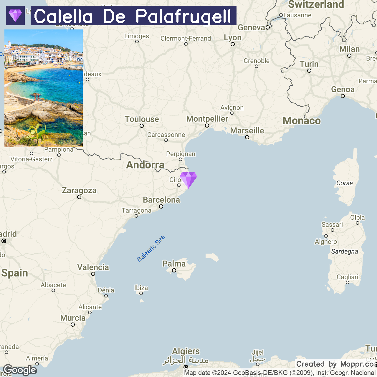
27. Calella de Palafrugell

Calella de Palafrugell, a quaint village on the Costa Brava, merges the allure of traditional fishing hamlets with Mediterranean charm.
Its whitewashed buildings and pristine coves epitomize a peaceful coastal life, especially in summer, with its seaside melodies and alfresco dining. Renowned beaches like Platja Port Bo offer perfect settings for water activities.
The Camí de Ronda path unveils breathtaking views and hidden coves, enhancing Calella’s appeal as a tranquil, culturally rich escape from the usual tourist hustle.
- ✈️ How to Get There: Calella de Palafrugell is best reached from Girona or Barcelona, with both cities offering international airports. The drive from Girona takes about an hour, while Barcelona is approximately a 1.5-hour drive away.
- 🏨 Where to Stay: Nestled in the heart of the village, the Hotel Alga offers guests a spacious and comfortable base, complete with lush gardens and pools. For those seeking a more intimate experience, the Hotel Sant Roc boasts a cliff-top location with breathtaking views.
28. Potes

Potes, nestled in Cantabria, is the picturesque entrance to the Picos de Europa National Park, boasting medieval charm with its stone bridges and historic streets.
It’s a haven for adventurers and culture seekers, offering outdoor activities and a rich taste of local traditions, highlighted by the Festival of the Orujo spirit.
With its mild summer climate, Potes is perfect for exploring its natural beauty and historical sites, which provide sweeping views of the town and its lush surroundings.

- ✈️ How to Get There: Potes is most accessible from Santander, about a 2-hour drive away. The journey through the Cantabrian countryside to the heart of the Liébana Valley is as picturesque as the destination.
- 🏨 Where to Stay: For a rustic experience, the Haras Artiza, Ojedo combines traditional Cantabrian architecture with cozy, modern amenities. The Hotel Infantado, nestled in the heart of Potes, is celebrated for its inviting atmosphere and comfortable accommodations, providing a genuine town experience.
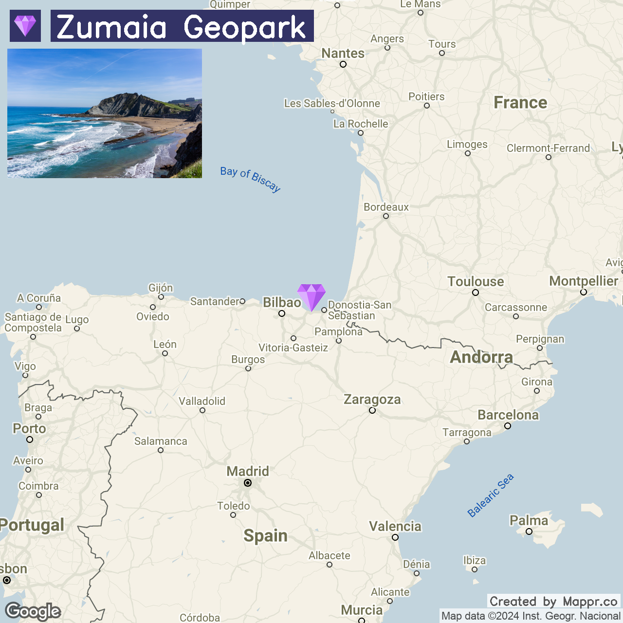
29. Zumaia Geopark

Zumaia Geopark, set along the Basque Country’s coast, captivates with its Flysch cliffs and geological wonders, revealing Earth’s ancient history.
This destination draws geologists, nature lovers, and photographers, especially in summer, for its stunning landscapes and inviting beaches like Playa de Itzurun.
Beyond the shoreline, hiking trails through lush hillsides offer a glimpse into the area’s biodiversity, while Zumaia’s cultural and culinary offerings enrich the experience, making it an ideal summer retreat.
- ✈️ How to Get There: Zumaia is easily accessible from San Sebastián or Bilbao. The drive from San Sebastián takes about 30 minutes, while Bilbao is approximately an hour away.
- 🏨 Where to Stay: The Hotel Flysch, located near the iconic cliffs, offers modern accommodations with spectacular views of the sea and the Geopark. Hotel & Talasoterapia Zelai, positioned along the coast, provides a unique wellness experience with its thalassotherapy treatments and oceanfront location.
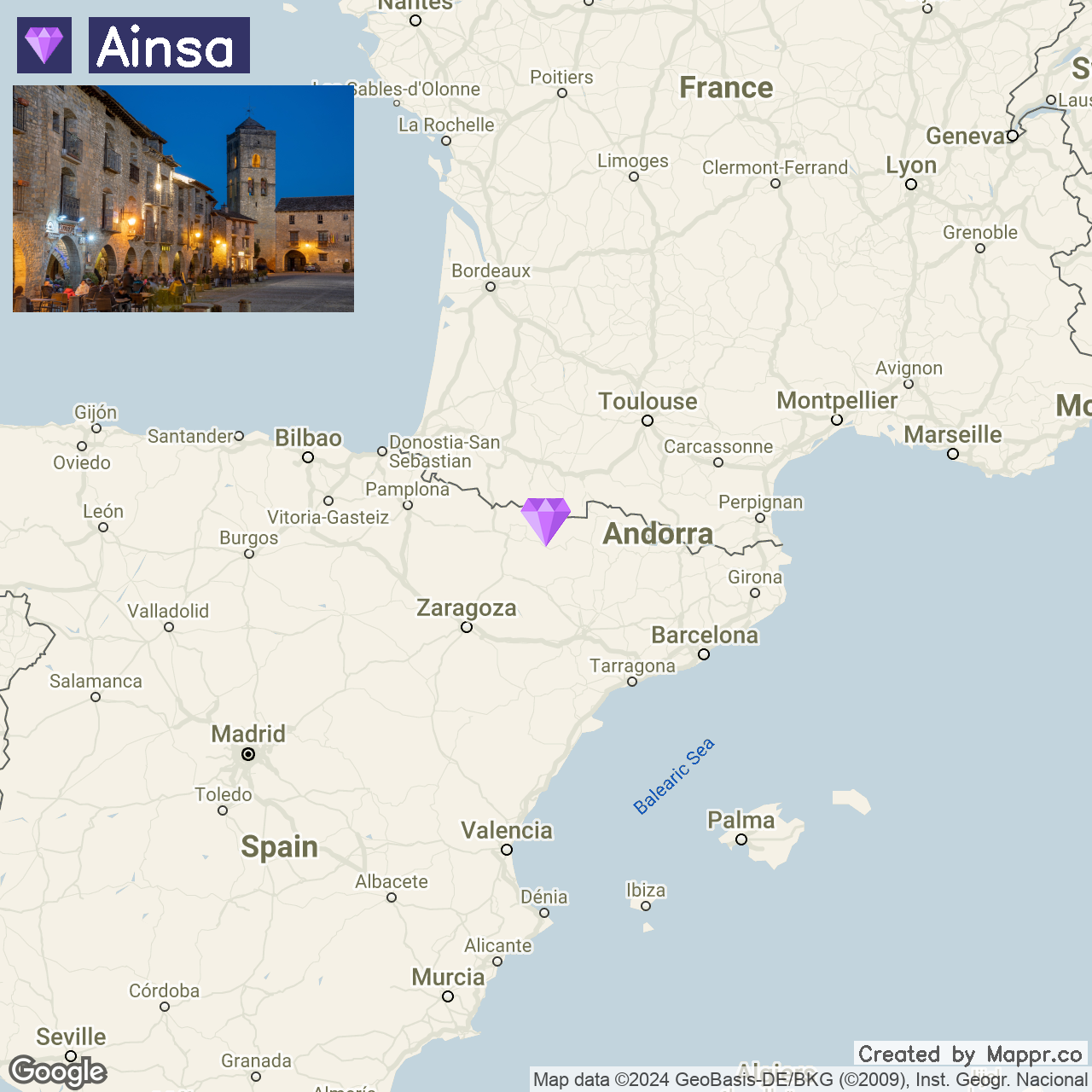
30. Aínsa

Aínsa, a medieval treasure in the Pyrenees, boasts a preserved center with a striking castle and ancient squares. Bordering Ordesa y Monte Perdido National Park, it’s perfect for exploring diverse landscapes and wildlife.
Its location by the Cinca and Ara rivers enhances its scenic appeal, offering a mix of history, culture, and nature. Vibrant summer festivals and local cuisine reflect Aínsa’s rich heritage, making it a lively and flavorful destination.
- ✈️ How to Get There: Aínsa is best reached from Zaragoza or Barcelona, with each city providing the nearest airports. The drive from Zaragoza takes about 2.5 hours, while Barcelona is approximately a 3.5-hour drive away.
- 🏨 Where to Stay: The Hotel Los Siete Reyes offers a luxurious stay in a beautifully restored historic building in the heart of Aínsa. For a more secluded retreat, the Hotel Apolo Aínsa, set on the town’s outskirts, provides a peaceful escape with modern amenities and easy access to nature.
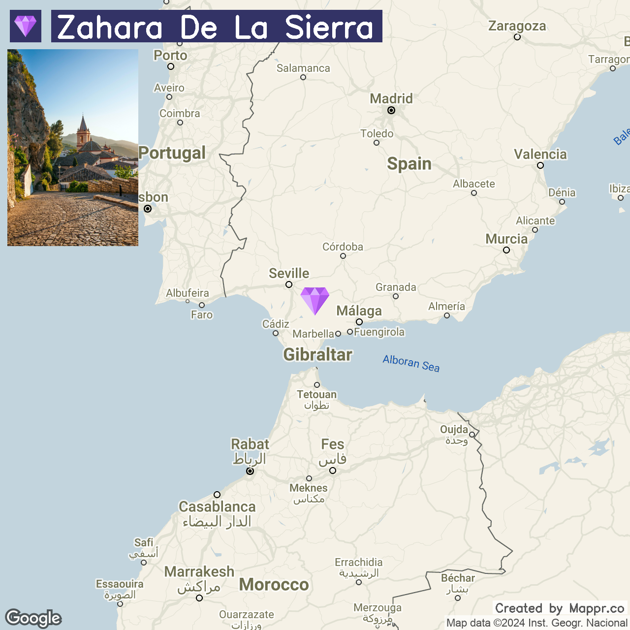
31. Zahara de la Sierra

Zahara de la Sierra, overlooking the Zahara-El Gastor reservoir, is a gem among Andalusia’s White Villages, crowned by a Moorish castle with stunning views of the Sierra de Grazalema.
Its charm comes from its flower-lined, whitewashed houses and peaceful ambiance, making it a haven for summer outdoor pursuits like hiking and watersports.
Positioned ideally, Zahara is a gateway to explore the verdant valleys and peaks of the UNESCO-protected Sierra de Grazalema.
- ✈️ How to Get There: Zahara de la Sierra is most conveniently accessed from Seville or Malaga, with both cities providing international airports. The drive from Seville takes about 1.5 hours, while Malaga is approximately a 2-hour away.
- 🏨 Where to Stay: The Al Lago Hotel offers a boutique experience with its stunning lake views and a commitment to local cuisine. For those seeking an immersion in nature, the Casa Rural El Vihuelo provides a unique accommodation experience, combining traditional architecture with modern comforts.
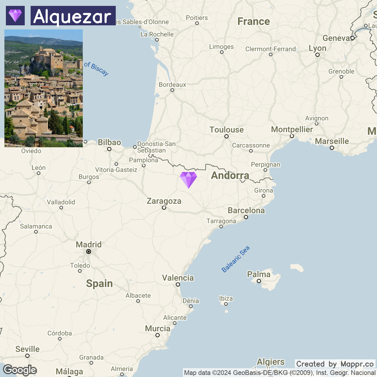
32. Alquézar

Alquézar, nestled in the Sierra de Guara, mesmerizes with its canyon views, medieval charm, and adventure activities.
Its streets lead to the prominent Collegiate Church, set against the Vero River canyon backdrop, ideal for canyoning, climbing, and hiking past ancient art.
As a portal to the Somontano wine region, Alquézar offers a fusion of heritage, nature, and culinary experiences.
- ✈️ How to Get There: Alquézar is best reached from Zaragoza or Huesca, with Zaragoza offering the nearest major airport. The drive from Zaragoza takes about 2 hours, traversing the arid landscapes of Aragon.
- 🏨 Where to Stay: The Hotel Castillo de Alquézar offers guests the chance to stay in a converted historic building with stunning town views and the surrounding canyons. Alternatively, the Parador de Alquézar, situated on the canyon’s edge, combines luxury with breathtaking natural scenery.
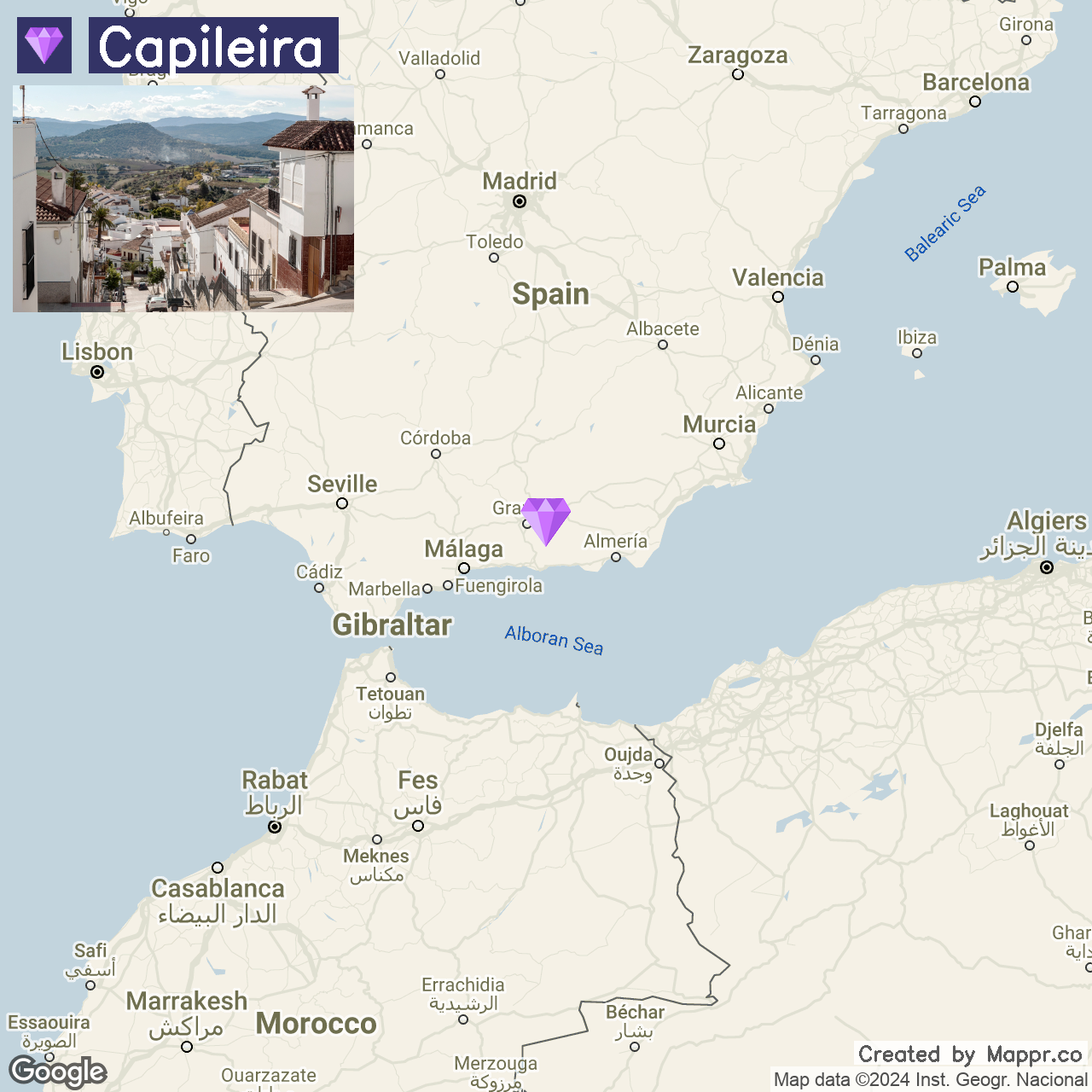
33. Capileira

Capileira is among the highest and most picturesque villages in the Alpujarras region, offering stunning views of the Sierra Nevada and the deep Poqueira Gorge.
This village is characterized by its terraced agriculture, narrow streets, and white Berber-style houses with flat clay roofs, reflecting a blend of Moorish and Andalusian influences.
Capileira is an ideal base for exploring the Sierra Nevada National Park, with its many hiking trails, including the route to the summit of Mulhacén, mainland Spain’s highest peak.
- ✈️ How to Get There: Capileira is most accessible from Granada, driving about 1.5 hours through the picturesque Alpujarras countryside.
- 🏨 Where to Stay: The Hotel Rural Poqueira II offers a rustic charm with its traditional Alpujarran architecture, modern amenities, and stunning mountain views. For a touch of luxury, the Finca Los Llanos provides comfortable accommodations, an outdoor pool, and a restaurant serving authentic local cuisine.
Final Thoughts
Spain’s hidden gems offer unique experiences beyond popular tourist destinations’ well-trodden paths.
From the rugged beauty to immersive destinations and breathtaking natural landscapes, these lesser-known towns and villages provide a peaceful retreat from the hustle and bustle of city life and offer a deeper connection to Spain’s diverse heritage, making every visit a uniquely enriching experience.


- Aerial View of Medieval Fortress and Church — © Jon Chica/Shutterstock
- Medieval Town by the Lake — © Angel L/Shutterstock
- Ancient Roman Theater in Cartagena — © Madrugada Verde/Shutterstock
- Cobblestone Street in Rupit, Spain — © Manamana/Shutterstock
- Cathedral of El Burgo de Osma at Dusk — © KarSol/Shutterstock
- Roman Ruins of Acinipo Against Blue Sky — © Joaquin Ossorio Castillo/Shutterstock
- Waterfall in Cazorla Natural Park — © Javier Ocampo Bernasconi/Shutterstock
- Wooden Pathway Leading to Serene Beach Cove — © Lozanolphoto/Shutterstock
- Rock Formations Under Blue Sky — © evantravels/Shutterstock
- River Meander Through Lush Green Hills at Sunset — © JuanLorAr/Shutterstock
- Windmills at Campo de Criptana under Blue Sky — © Richard Semik/Shutterstock
- Boats in Castro Urdiales Harbor — © tichr/Shutterstock
- Fountain in Front of Royal Palace of El Pardo — © Songquan Deng/Shutterstock
- Monument on Coastal Hill at Sunrise — © tichr/Shutterstock
- Narrow Street with Colorful Buildings in Cuenca, Spain — © trabantos/Shutterstock
- Hilltop Castle Overlooking a Village — © GranTotufo/Shutterstock
- Cudillero Village at Dusk — © lunamarina/Shutterstock
- Sunny Day in Frigiliana Village — © Sopotnicki/Shutterstock
- Setenil de las Bodegas Town Under Overhanging Cliff — © essevu/Shutterstock
- Narrow Street in Mijas, Spain with Flower Pots and Sea View — © essevu/Shutterstock
- White Buildings of Salobrena, Spain — © Munimara/Shutterstock
- Coastal Town Overlooking Bay with Historic Towers — © kavalenkava/Shutterstock
- Charming Street with White Buildings and Castle in the Background — © Rolf E. Staerk/Shutterstock
- Aerial View of Peñíscola Lighthouse by the Sea — © Celeste Fibla Beltran/Shutterstock
- Colorful Coastal Village with Boats and Palm Trees — © Wolfgang Jargstorff/Shutterstock
- Sunset Over Albarracín Village — © StockPhotoAstur/Shutterstock
- Coastal Village and Clear Blue Sea — © Pawel Kazmierczak/Shutterstock
- Scenic View of Potes, Spain with Mountains and Greenery — © GranTotufo/Shutterstock
- Zumaia Geopark Coastline — © EDER OLCOZ ACHA/Shutterstock
- Evening in Ainsa, Spain – Street View with People Dining Outdoors — © Ana del Castillo/Shutterstock
- Cobbled Street Leading to a Church in Zahara de la Sierra — © Tom Plesnik/Shutterstock
- Medieval Village on a Hillside — © astudio/Shutterstock
- Whitewashed Village Street with Mountain View — © GranTotufo/Shutterstock