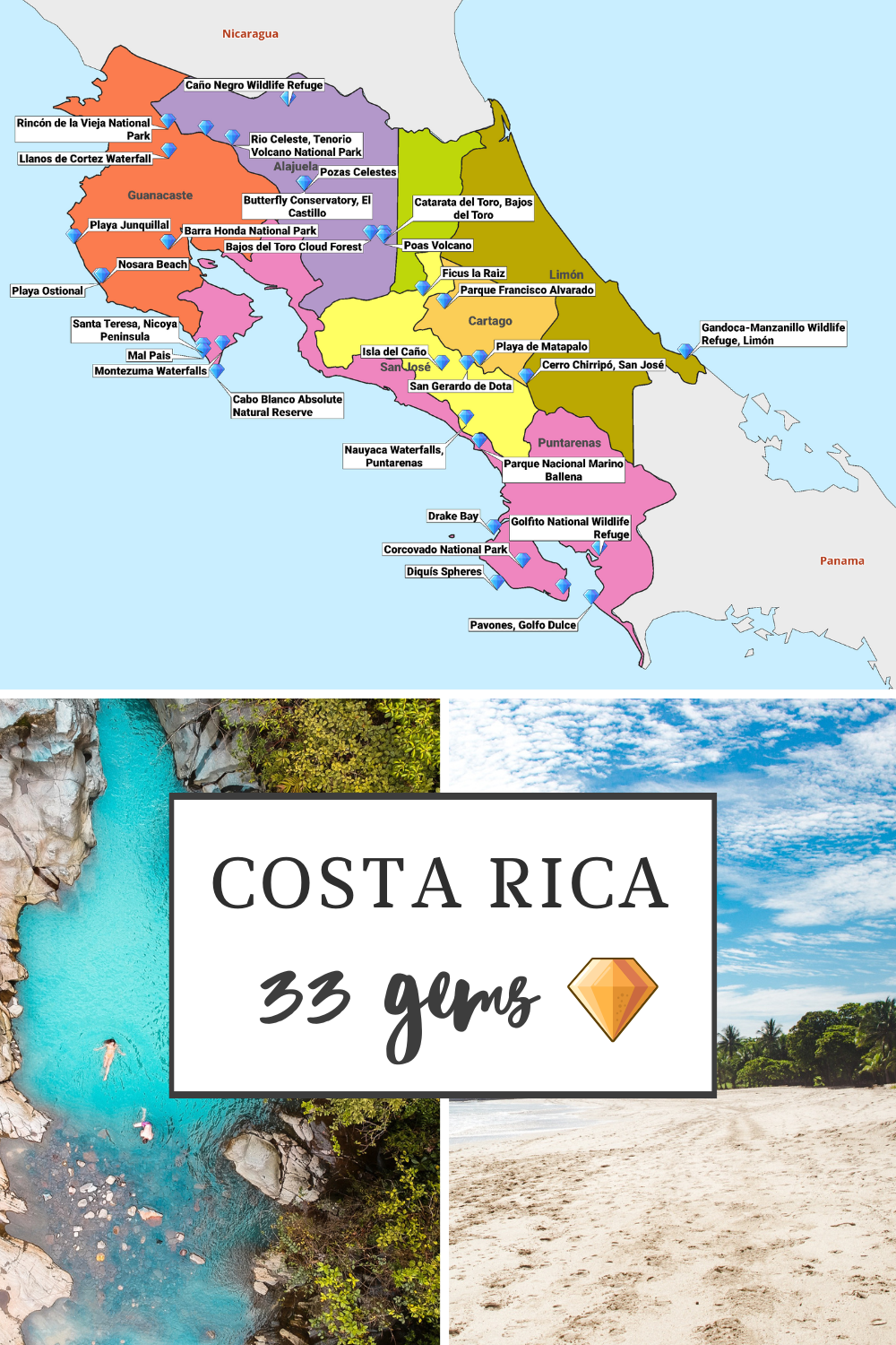
Costa Rica is a verdant jewel between the Pacific and Caribbean oceans. While many travelers flock to its well-trodden paths, the true essence of this enchanting country lies beyond the tourist hotspots.
In this article, “Hidden Gems in Costa Rica in the Summer,” we journey to uncover the less-known treasures that flourish under the warm summer sun.
From secluded waterfalls to untouched beaches and quaint villages, to rare wildlife habitats, we’ll explore the corners of Costa Rica that offer a unique glimpse into its natural beauty and cultural richness, away from the crowds.
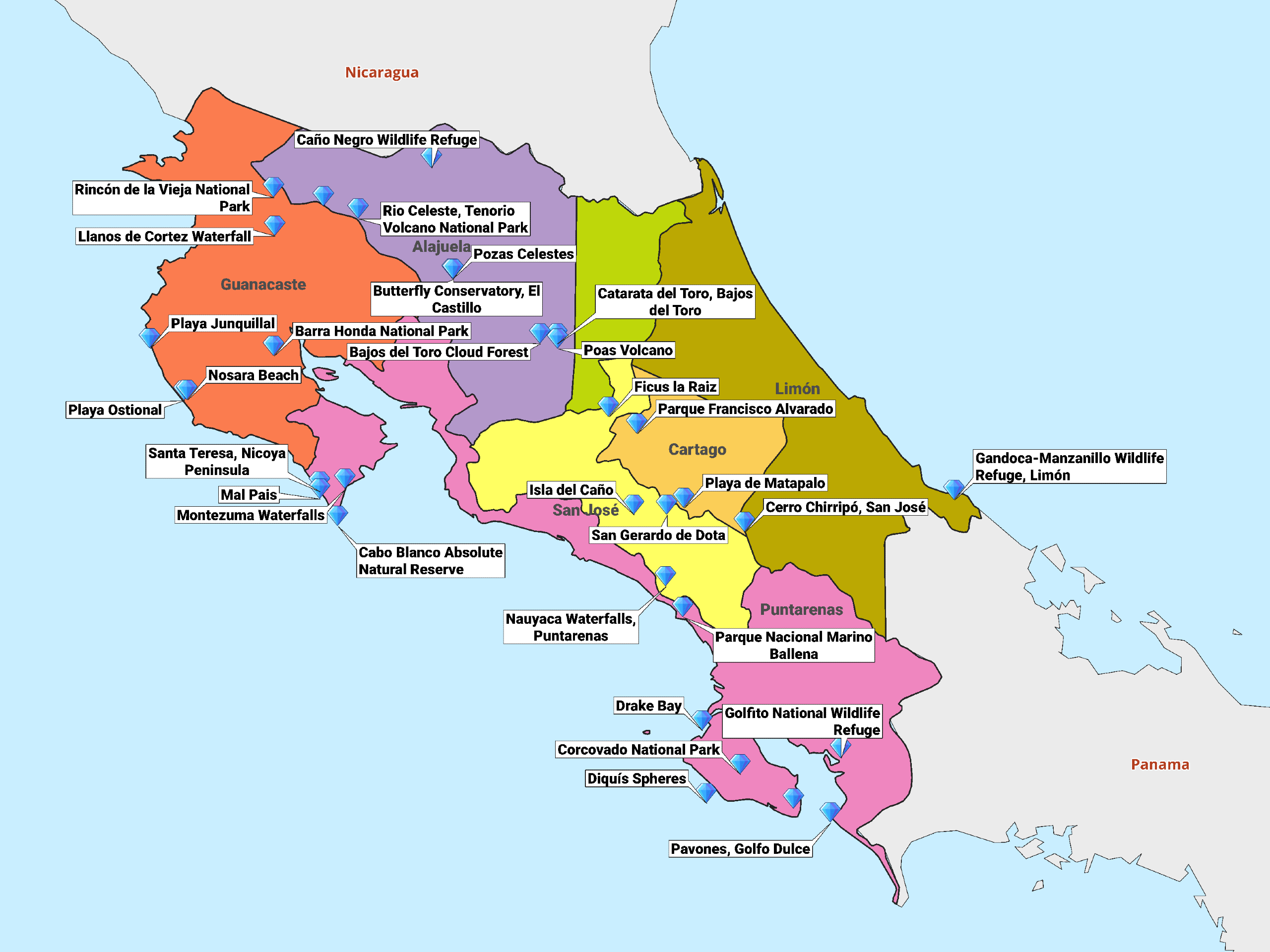
| Place | Region | Closest Int. Airport |
|---|---|---|
| Montezuma Waterfalls | Nicoya Peninsula | Juan Santamaría International Airport |
| Santa Teresa, Nicoya Peninsula | Nicoya Peninsula | Tambor Airport (Domestic) |
| Nauyaca Waterfalls, Puntarenas | Puntarenas | Juan Santamaría International Airport |
| Rio Celeste, Tenorio Volcano National Park | Guanacaste | Daniel Oduber Quirós International Airport |
| San Gerardo de Dota | San José | Juan Santamaría International Airport |
| Gandoca-Manzanillo Wildlife Refuge, Limón | Limón | Juan Santamaría International Airport |
| Catarata del Toro, Bajos del Toro | Alajuela | Juan Santamaría International Airport |
| Pavones, Golfo Dulce | Puntarenas | Juan Santamaría International Airport |
| Isla del Caño | Puntarenas | Juan Santamaría International Airport |
| Corcovado National Park | Puntarenas | Juan Santamaría International Airport |
| Bajos del Toro Cloud Forest | Alajuela | Juan Santamaría International Airport |
| Rincón de la Vieja National Park | Guanacaste | Daniel Oduber Quirós International Airport |
| Cabo Blanco Absolute Natural Reserve | Nicoya Peninsula | Juan Santamaría International Airport |
| Playa Junquillal | Guanacaste | Daniel Oduber Quirós International Airport |
| Barra Honda National Park | Nicoya Peninsula | Daniel Oduber Quirós International Airport |
| Drake Bay | Puntarenas | Juan Santamaría International Airport |
| Playa Ostional | Guanacaste | Daniel Oduber Quirós International Airport |
| Miravalles Volcano, Guanacaste | Guanacaste | Daniel Oduber Quirós International Airport |
| Llanos de Cortez Waterfall | Guanacaste | Daniel Oduber Quirós International Airport |
| Carate, Osa Peninsula | Puntarenas | Juan Santamaría International Airport |
| Playa de Matapalo | Puntarenas | Juan Santamaría International Airport |
| Caño Negro Wildlife Refuge | Alajuela | Juan Santamaría International Airport |
| Cerro Chirripó, San José | San José | Juan Santamaría International Airport |
| Parque Nacional Marino Ballena | Puntarenas | Quepos Airport (Domestic) |
| Poas Volcano | Alajuela | Juan Santamaría International Airport |
| Mal Pais | Nicoya Peninsula | Tambor Airport (Domestic) |
| Golfito National Wildlife Refuge | Puntarenas | Golfito Airport (Domestic) |
| Parque Francisco Alvarado | Alajuela | Juan Santamaría International Airport |
| Nosara Beach | Guanacaste | Nosara Airport (Domestic) |
| Diquís Spheres | Puntarenas | Juan Santamaría International Airport |
| Ficus la Raiz, Monteverde | Puntarenas | Juan Santamaría International Airport |
| Pozas Celestes, Dota | San José | Juan Santamaría International Airport |
| Butterfly Conservatory, El Castillo | Alajuela | Juan Santamaría International Airport |
1. Montezuma Waterfalls

Montezuma Waterfalls is a breathtaking natural attraction nestled in the heart of the Nicoya Peninsula, inviting adventurers and nature lovers to explore its cascading beauty.
This hidden gem is renowned for its three stunning waterfalls, each offering a unique experience, from serene pools perfect for swimming to dramatic drops that create a mesmerizing mist.
The lush surroundings and vibrant wildlife add to the allure, making it a serene escape for those seeking to connect with nature’s untouched beauty.
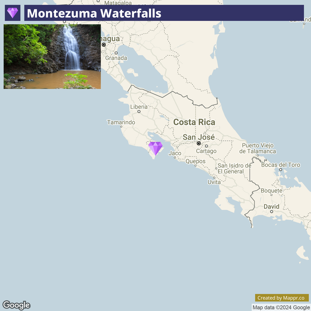
- ✈️ How to Get There: Montezuma Waterfalls is accessible from the town of Montezuma, situated at the tip of the Nicoya Peninsula. The nearest major airport is Juan Santamaría International Airport in San José, with several transportation options available.
- 🏨 Where to Stay: For those seeking to immerse themselves in the natural beauty of Montezuma, consider staying at the Casitas Sollevante Boutique Hotel, offering beachfront bungalows and garden views, or the Montezuma Pacific Hotel, known for its cozy rooms and proximity to local attractions.
2. Santa Teresa, Nicoya Peninsula

Santa Teresa is a charming surf village that has quietly become one of Costa Rica’s most coveted destinations for surfers, yogis, and beach lovers. Its pristine beaches, consistent surf breaks, and laid-back atmosphere provide a perfect backdrop for a tranquil getaway.
The village’s bohemian vibe and a growing community of international cuisine, boutique accommodations, and wellness retreats make it an idyllic spot for those looking to unwind and recharge.
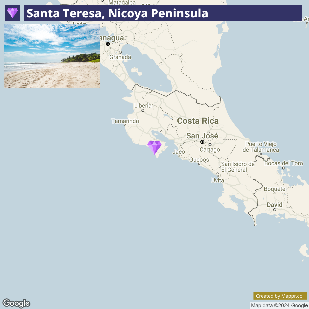
- ✈️ How to Get There: Santa Teresa is situated on the Nicoya Peninsula, accessible via driving and ferry from San José or by domestic flights to the nearby Tambor Airport.
- 🏨 Where to Stay: In Santa Teresa, the options for accommodations range from the luxurious Hotel Vista de Olas, offering villas with private pools and ocean views, to the more laid-back Gigi Brown Beachfront, ideal for adventurers in a communal setting.
3. Nauyaca Waterfalls, Puntarenas

Nauyaca Waterfalls is a majestic natural wonder located in the province of Puntarenas, offering one of the most impressive waterfall experiences in Costa Rica.
The falls consist of two tiers, with a combined height of approximately 65 meters, creating a powerful spectacle of water plunging into a large, tranquil pool below, perfect for swimming and relaxation.
The journey to Nauyaca Waterfalls involves a hike through lush rainforest, providing an opportunity to witness the diverse flora and fauna of the region.
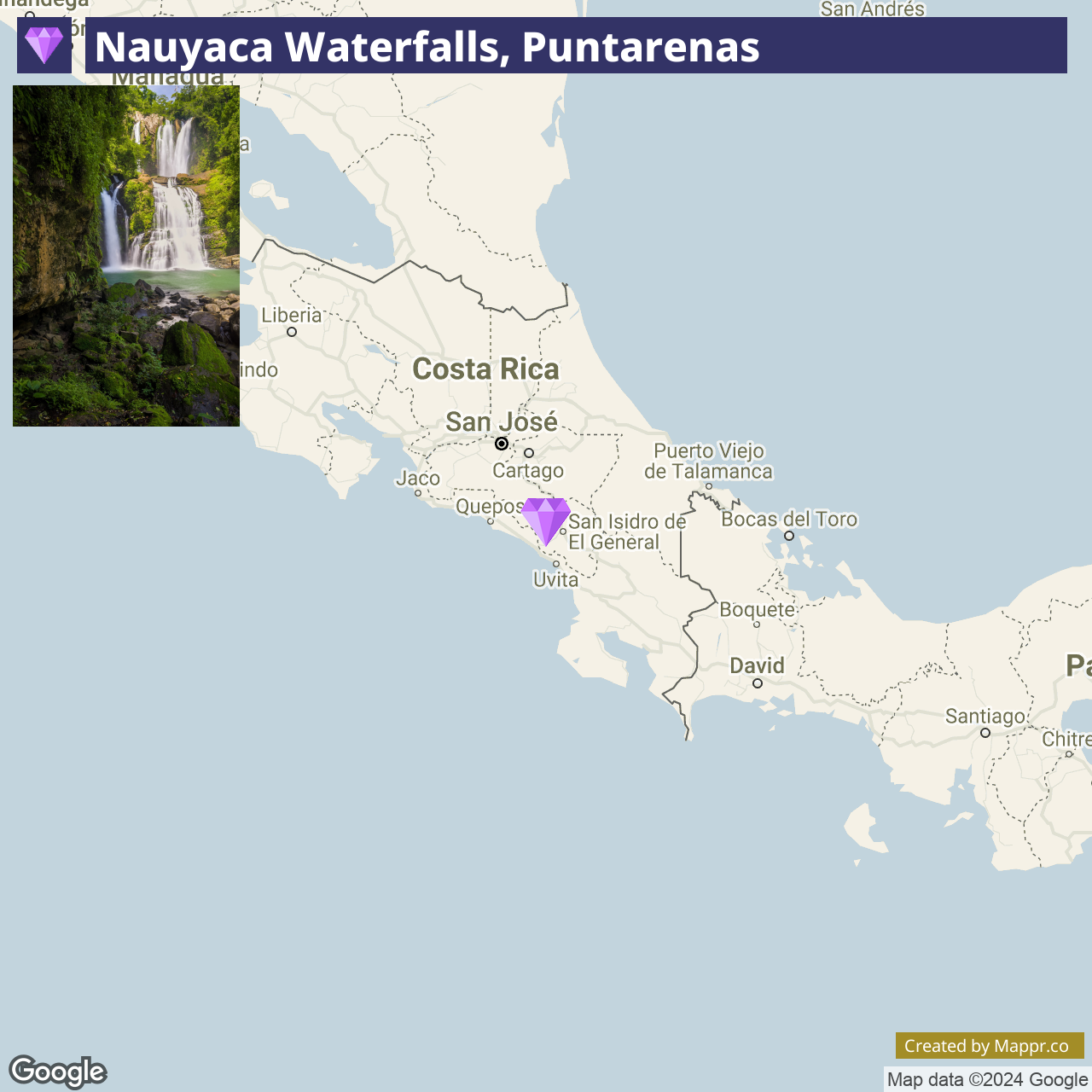
- ✈️ How to Get There: Nauyaca Waterfalls can be accessed from Dominical, a small beach town on the Pacific Coast. The nearest international airport is Juan Santamaría International Airport in San José.
- 🏨 Where to Stay: Accommodation options near Nauyaca Waterfalls include the Bamboo River House and Hotel, offering unique stays in tree houses and jungle lodges, or the Lapazul Boutique Hotel, known for its stunning mountain views and eco-friendly practices.
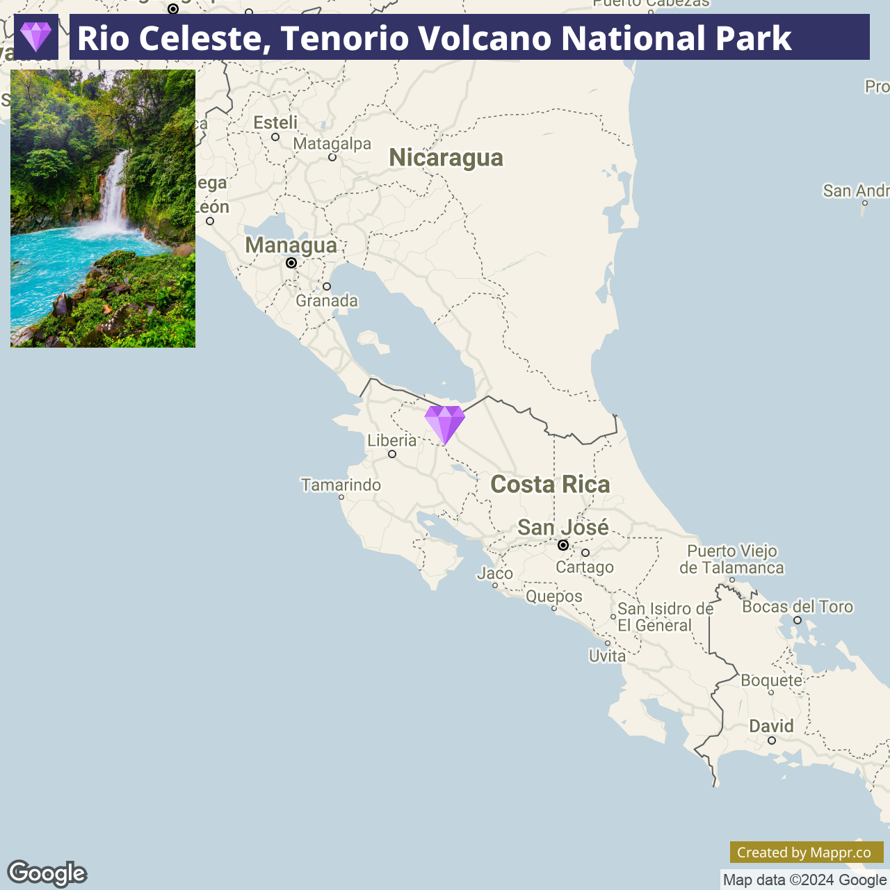
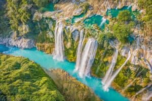
4. Rio Celeste, Tenorio Volcano National Park

Rio Celeste is a mystical river located within the Tenorio Volcano National Park, famous for its striking turquoise waters, a phenomenon caused by a natural chemical reaction of volcanic minerals.
The hike to Rio Celeste takes visitors through dense rainforest, past bubbling hot springs, and to the mesmerizing Rio Celeste Waterfall, creating a vivid contrast with the lush green surroundings.
This enchanting destination is perfect for those looking to experience the magic of Costa Rica’s volcanic landscapes and the tranquility of its untouched forests.
- ✈️ How to Get There: Rio Celeste is best accessed from Bijagua, located between Liberia and La Fortuna. The nearest airport is Daniel Oduber Quirós International Airport in Liberia.
- 🏨 Where to Stay: Near Rio Celeste, consider staying at the Celeste Mountain Lodge, known for its eco-friendly design and panoramic views, or the Rio Celeste Hideaway Hotel, offering luxurious casitas and easy access to the park’s natural attractions.
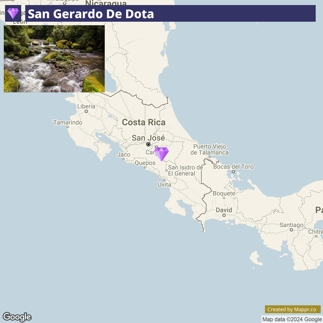
5. San Gerardo de Dota

San Gerardo de Dota, nestled in the high-altitude cloud forests of Los Quetzales National Park, is a paradise for birdwatchers and nature lovers.
This serene valley is renowned for its population of resplendent quetzals, offering visitors the chance to spot these elusive birds amidst a backdrop of lush vegetation and crystal-clear streams.
The area’s cool climate and tranquil atmosphere make it an ideal retreat for those seeking a peaceful escape in the mountains, with opportunities for trout fishing, hiking, and immersing in the cloud forest’s mystical ambiance.
- ✈️ How to Get There: Located in the Talamanca Mountains, San Gerardo de Dota is about a two-hour drive from San José. The journey offers breathtaking views of the Costa Rican landscape.
- 🏨 Where to Stay: Accommodations like the Trogon Lodge and Savegre Hotel provide cozy mountain lodges and cabins with access to nature trails and birdwatching tours, encapsulating the essence of highland hospitality.
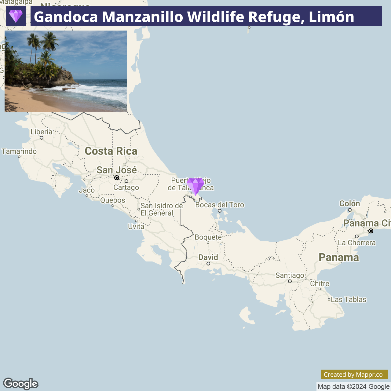
6. Gandoca-Manzanillo Wildlife Refuge, Limón

The Gandoca-Manzanillo Wildlife Refuge in Limón is a coastal haven with biodiversity, from vibrant coral reefs to dense tropical rainforests.
This off-the-beaten-path destination offers a unique blend of ecological wonders, including mangrove swamps, a turtle-nesting beach, and a marine area rich in aquatic life.
Ideal for eco-tourists and adventure seekers, the refuge provides a variety of experiences, from snorkeling and kayaking to jungle hikes, where the untouched beauty of Costa Rica’s Caribbean coast can be fully appreciated.
- ✈️ How to Get There: The refuge is located near the small town of Manzanillo, at the southern end of the Limón coastline. It’s accessible from San José by bus or car, with the journey showcasing the diverse landscapes.
- 🏨 Where to Stay: In the vicinity, options range from the laid-back beachfront cabins of Almonds and Corals Lodge, offering an immersive rainforest experience and a closer connection to the community and nature.
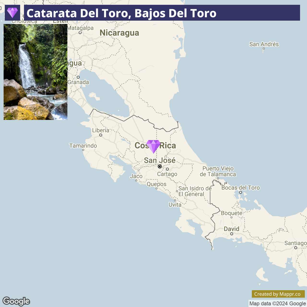
7. Catarata del Toro, Bajos del Toro

Catarata del Toro is a breathtaking waterfall in the Bajos del Toro cloud forest, featuring a dramatic 90-meter drop into an extinct volcanic crater.
Surrounded by lush vegetation and vibrant flora, this impressive waterfall offers a unique and awe-inspiring natural spectacle.
The area around Catarata del Toro is a haven for birdwatchers and nature enthusiasts, with numerous trails leading through the cloud forest to hidden waterfalls and scenic viewpoints.
- ✈️ How to Get There: Bajos del Toro can be reached by car from San José in about 2 hours, offering a scenic drive through the mountains and countryside.
- 🏨 Where to Stay: Nearby accommodations include the El Silencio Lodge & Spa, providing a luxurious retreat in the heart of the cloud forest, or the more rustic but charming Bosque de Paz, nestled within a private nature reserve.
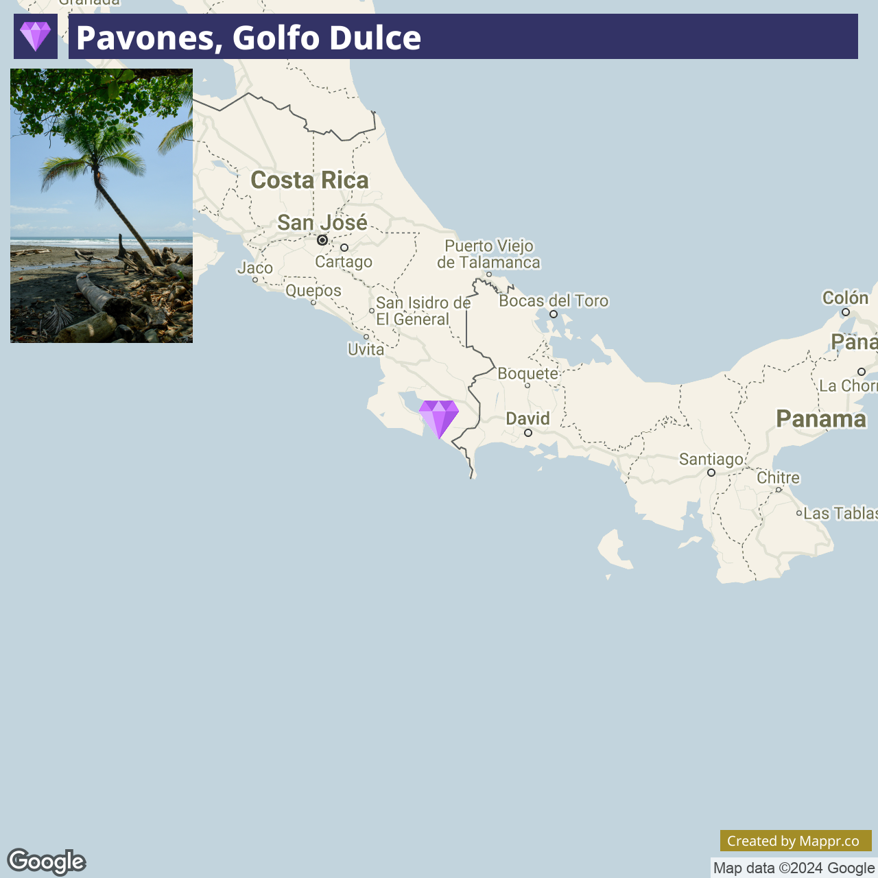
8. Pavones, Golfo Dulce

Pavones, located along the southern Pacific coast of Costa Rica, is famed for having one of the longest left-hand surf breaks in the world. This remote surf village attracts surfers from around the globe seeking to ride its epic waves.
Beyond surfing, Pavones offers a laid-back lifestyle, untouched nature, yoga retreats, and opportunities for wildlife watching, including sea turtles and exotic birds.
The area’s tranquility and natural beauty make it a perfect retreat for those looking to escape the crowds and immerse themselves in Costa Rica’s pura vida spirit.
- ✈️ How to Get There: Pavones is accessible by car from San José, with the journey taking approximately 7-8 hours, offering an authentic glimpse into the rural and coastal landscapes of Costa Rica.
- 🏨 Where to Stay: Accommodations in Pavones range from the simple and serene La Ponderosa Beach and Jungle Resort, offering beachfront access and nature tours, to the more intimate Tiskita Jungle Lodge, known for its stunning ocean views and peaceful environment.
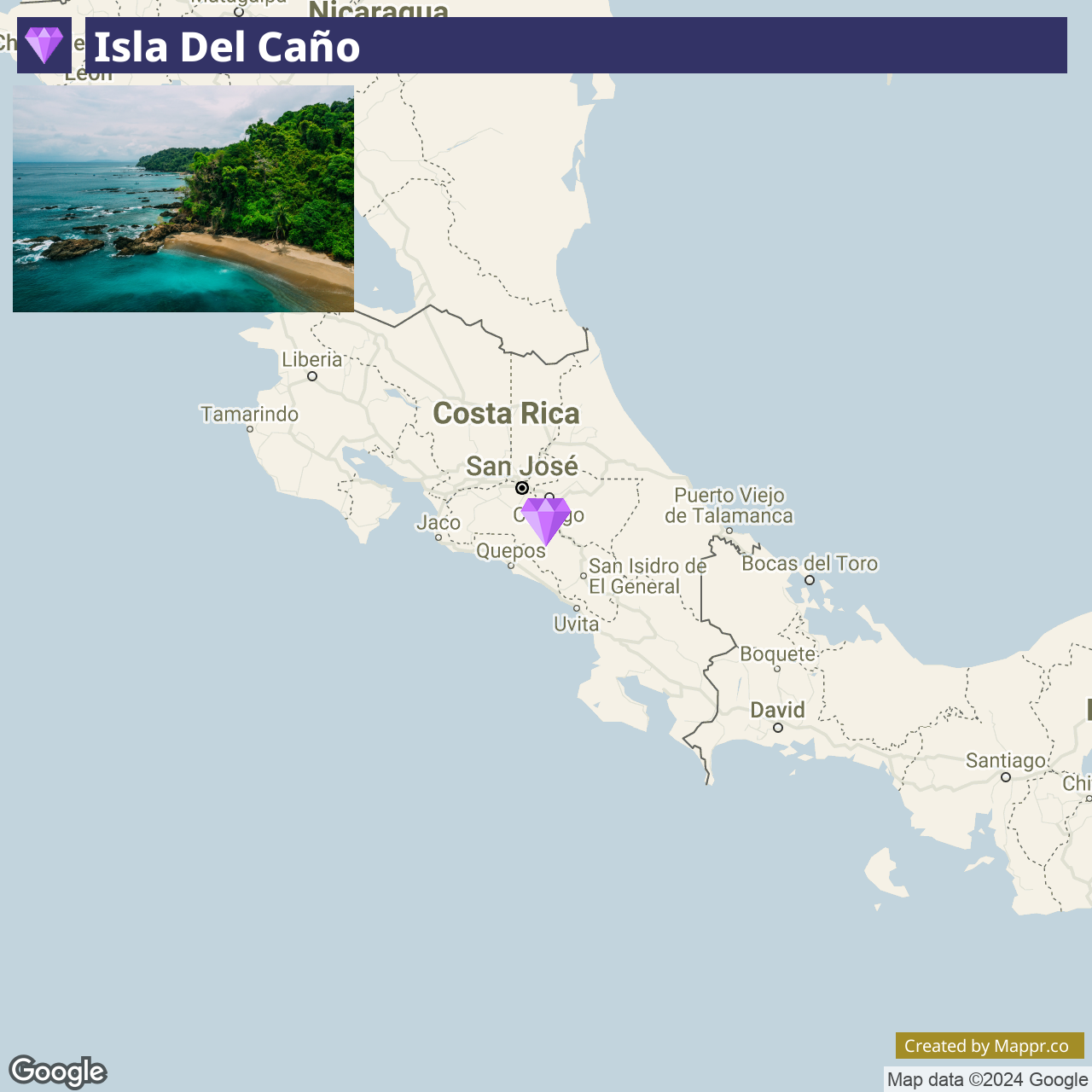
9. Isla del Caño

Isla del Caño is a small island off the coast of the Osa Peninsula, renowned for its crystal-clear waters and exceptional marine life, making it a premier spot for snorkeling and diving in Costa Rica.
The island, also an archaeological site, offers a blend of natural beauty and historical mystery, with ancient stone spheres and artifacts. Its protected waters are part of a biological reserve, home to vibrant coral reefs, schools of tropical fish, and, occasionally, passing whales and dolphins.
- ✈️ How to Get There: The island is most commonly accessed from Drake Bay or Sierpe on the Osa Peninsula, with boat trips providing an adventurous route to this marine paradise.
- 🏨 Where to Stay: In Drake Bay, consider the Bella Vista Corcovado for its stunning ocean views and proximity to nature. Alternatively, The Jaguar’s Jungle Rainforest Lodge offers an immersive rainforest experience and easy access to the abundant wildlife and natural wonders.
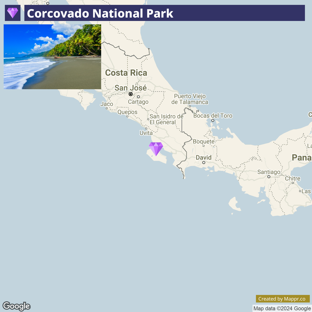
10. Corcovado National Park

The Osa Peninsula, home to the Corcovado National Park, is a haven for biodiversity, often described as one of Earth’s most biologically intense places.
This remote corner of Costa Rica offers pristine rainforests, secluded beaches, and a wealth of wildlife, including jaguars, scarlet macaws, and tapirs. Corcovado’s rugged terrain and untouched beauty make it an unparalleled destination for eco-tourists and adventure seekers.
- ✈️ How to Get There: Reachable from San José by a combination of domestic flights to Puerto Jiménez or Drake Bay, followed by a short drive or boat ride to the park.
- 🏨 Where to Stay: Options range from eco-lodges like Lapa Rios Lodge, set within a private nature reserve, to the more rustic SCP Corcovado Wilderness Lodge, offering a closer-to-nature experience.
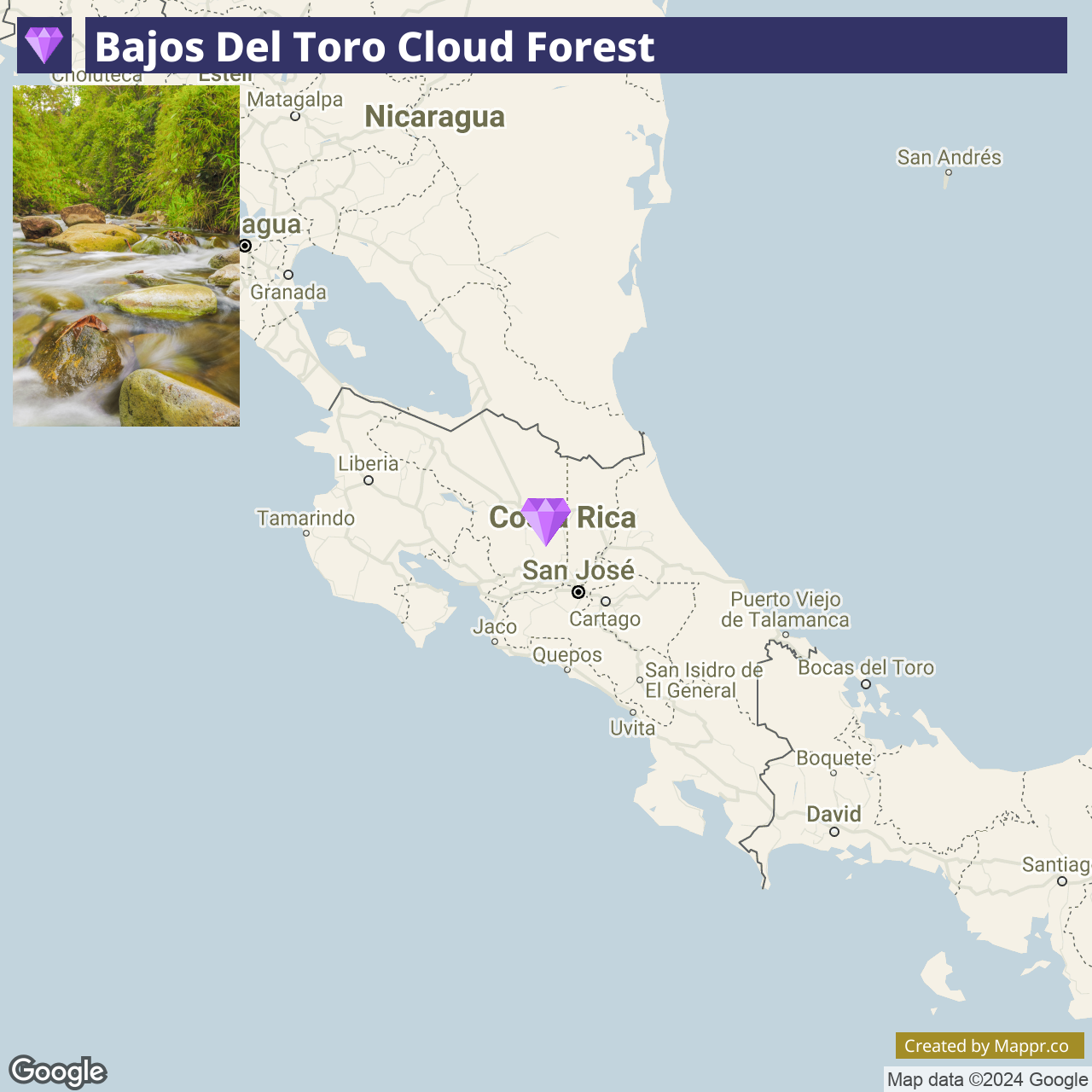
11. Bajos del Toro Cloud Forest

The Bajos del Toro cloud forest is a hidden gem in the Alajuela province, offering visitors a serene escape into a lush, mist-covered ecosystem.
Renowned for its abundant waterfalls, including the spectacular Catarata del Toro and the serene Blue Falls, Bajos del Toro is a paradise for nature lovers and photographers.
The area’s rich biodiversity, including a variety of orchids, birds, and mammals, makes it a prime spot for eco-tourism and nature exploration.
- ✈️ How to Get There: Bajos del Toro is easily accessible by car from San José, with the journey taking approximately 2 hours. The scenic drive through the Central Valley and into the cloud forest is part of the experience.
- 🏨 Where to Stay: The area offers a range of accommodations, from the luxurious El Silencio Lodge & Spa, with its private cloud forest reserve and upscale amenities, to the more modest but charming Bosque de Paz Eco Lodge, focused on conservation and a genuine cloud forest experience.
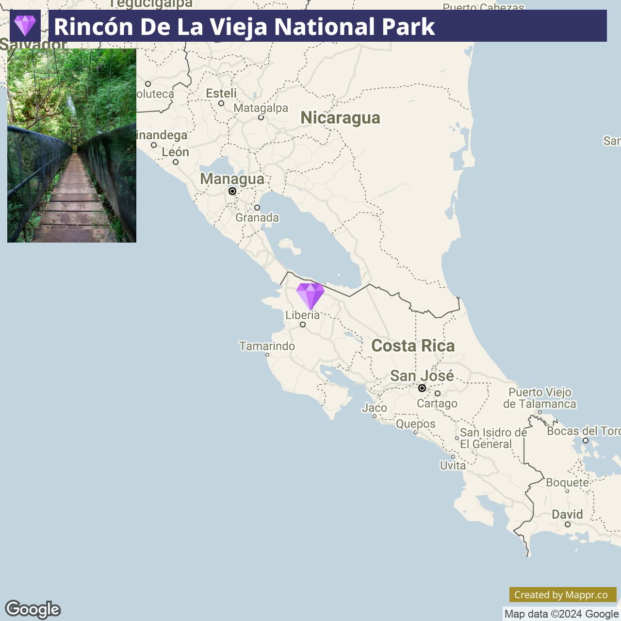
12. Rincón de la Vieja National Park

Rincón de la Vieja National Park is a geothermal wonderland in Guanacaste, showcasing an active volcano, bubbling mud pots, hot springs, and diverse flora and fauna.
The park’s numerous trails lead visitors through various ecosystems, from dry tropical forest to montane cloud forest, offering opportunities to spot wildlife such as howler monkeys, coatis, and many bird species.
The park is also known for its adventurous activities, including zip-lining, horseback riding, and waterfall rappelling.
- ✈️ How to Get There: The park is accessible from Liberia, the regional capital of Guanacaste, by car. The drive takes about an hour, leading through rural landscapes and into the volcano’s foothills.
- 🏨 Where to Stay: Nearby accommodations include the rustic Hacienda Guachipelin, offering a true Costa Rican ranch experience, and the tranquil Buena Vista del Rincón, set amidst lush forests and offering a range of eco-adventures.
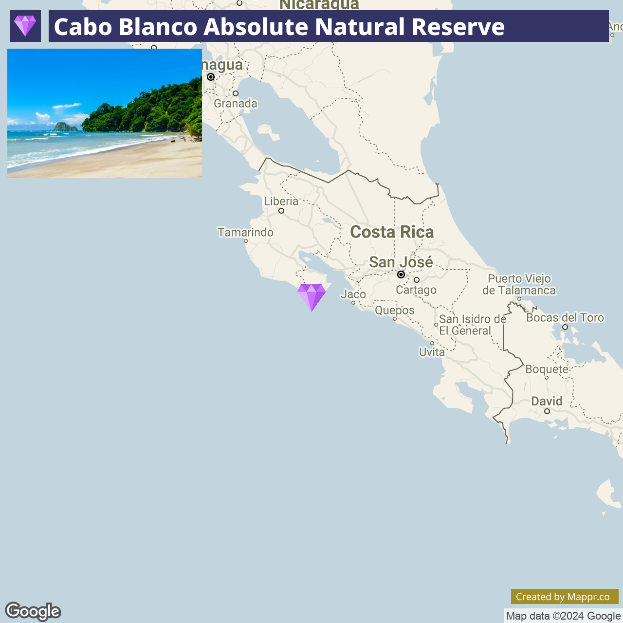
13. Cabo Blanco Absolute Natural Reserve

Cabo Blanco Absolute Natural Reserve stands as Costa Rica’s first protected area, a testament to the country’s commitment to conservation.
This hidden gem on the southern tip of the Nicoya Peninsula offers a pristine example of tropical dry forest transitioning to moist forest, with rugged trails leading to secluded beaches.
It’s a sanctuary for wildlife enthusiasts, bird watchers, and those seeking solace in nature’s embrace, offering a chance to explore diverse ecosystems and encounter rare species in their natural habitat.
- ✈️ How to Get There: Cabo Blanco is accessible from Montezuma or Santa Teresa by car or local bus. The nearest major airport is in San José, with travel options including a scenic ferry ride.
- 🏨 Where to Stay: Nearby Montezuma and Santa Teresa offer a range of accommodations, from the tranquil Jungle Lodge at Wild Sun Rescue Center with oceanfront views to the cozy Casa Marbella, close to local dining and entertainment.
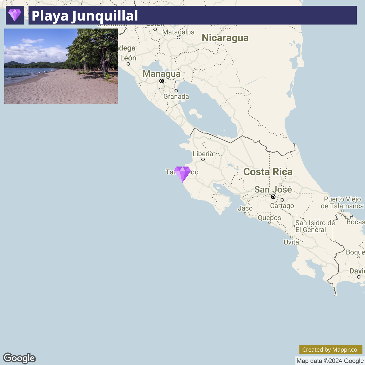
14. Playa Junquillal

Playa Junquillal is a serene and unspoiled beach in the Guanacaste province, known for its long stretches of sandy shoreline and crystal-clear waters.
This tranquil beach is perfect for those seeking a peaceful retreat away from crowded tourist spots, offering excellent conditions for swimming, surfing, and sunset walks.
The local community is committed to environmental preservation, making Playa Junquillal an exemplary model of sustainable tourism in Costa Rica.
- ✈️ How to Get There: Playa Junquillal is best accessed by car from Liberia or Santa Cruz, with the journey providing picturesque views of Guanacaste’s diverse landscapes.
- 🏨 Where to Stay: Accommodation options in Playa Junquillal include the cozy Blue Window Boutique Villas Hotel, offering comfortable rooms and easy beach access, and the Guacamaya Lodge, known for its beautiful garden setting and friendly atmosphere.
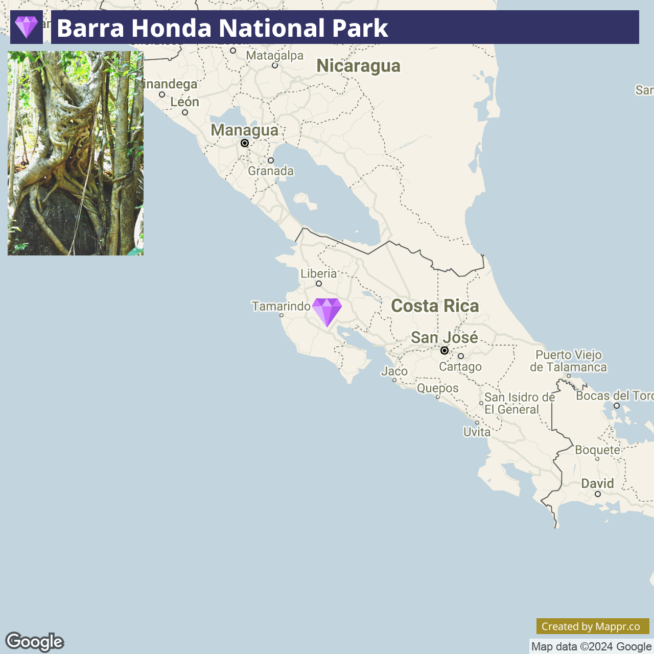
15. Barra Honda National Park

Barra Honda National Park is renowned for its intricate network of limestone caves, some adorned with ancient marine fossils and impressive stalactite and stalagmite formations.
This unique park offers a rare glimpse into the subterranean world of the Nicoya Peninsula. In addition to spelunking, the park features hiking trails that wind through dry tropical forests, home to various wildlife, including howler monkeys, bats, and numerous bird species.
Barra Honda is a destination for adventurers and nature enthusiasts keen on exploring the less-trodden paths of Costa Rica.
- ✈️ How to Get There: Located near Nicoya, Barra Honda National Park is accessible by car from Liberia or San José. The roads leading to the park offer a scenic drive-through.
- 🏨 Where to Stay: Nearby accommodations include the peaceful and family-friendly Casa Briza, offering easy access to the park and local cultural experiences, or the more secluded Hospedaje Angela, nestled among the hills and providing a tranquil retreat.
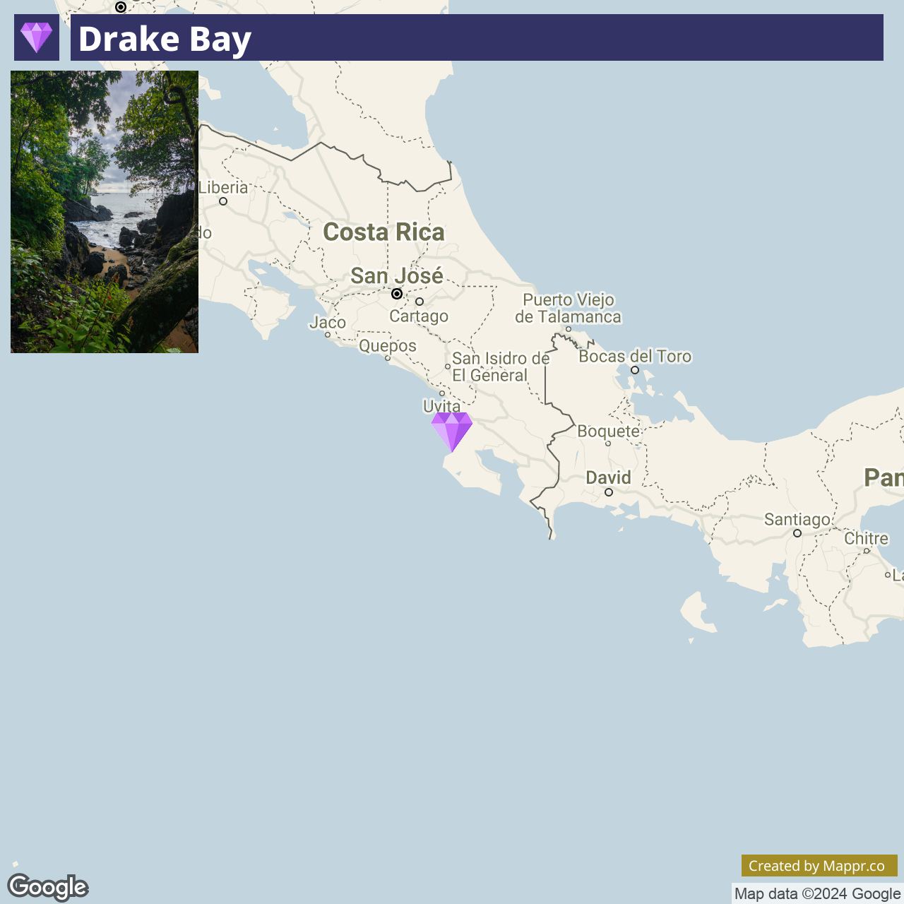
16. Drake Bay

Drake Bay is a secluded paradise on the Osa Peninsula’s northern side, serving as a gateway to the biodiverse Corcovado National Park.
With its stunning beaches, lush rainforests, and vibrant wildlife, this remote bay offers an immersive experience of Costa Rica’s untouched natural beauty.
Drake Bay is ideal for eco-tourists and adventurers, offering activities such as snorkeling at Isla del Caño, hiking, birdwatching, and exploring the dense rainforests that teem with exotic flora and fauna.
- ✈️ How to Get There: Drake Bay is accessible by boat from Sierpe, by small aircraft from San José, or by a challenging road journey, arriving an integral part of the adventure.
- 🏨 Where to Stay: Options in Drake Bay include the tranquil Copa de Arbol Beach and Rainforest Resort, offering eco-luxury amidst lush foliage, and the Drake Bay Wilderness Resort, known for its rustic charm and direct beach access.
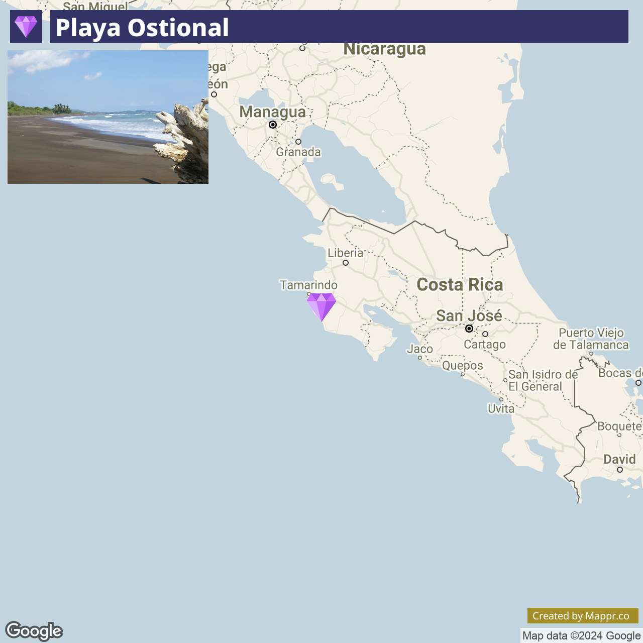
17. Playa Ostional

Playa Ostional is renowned for its awe-inspiring arribadas, where thousands of olive ridley sea turtles come ashore to nest, primarily during the rainy season. This natural phenomenon makes the beach vital for conservation and research, drawing biologists and nature enthusiasts worldwide.
Beyond its ecological significance, Playa Ostional offers rugged natural beauty, with volcanic black sands and powerful waves, making it a haven for surfers and those seeking a more untouched coastal experience.
- ✈️ How to Get There: Accessible by car from Nosara, a journey that offers a glimpse into the rural and coastal landscapes of the Nicoya Peninsula.
- 🏨 Where to Stay: In the nearby area of Nosara, accommodations range from the harmonious Bodhi Tree Yoga Resort, ideal for wellness enthusiasts, to the laid-back Olas Verdes Hotel, offering easy access to the area’s pristine beaches and surf spots.
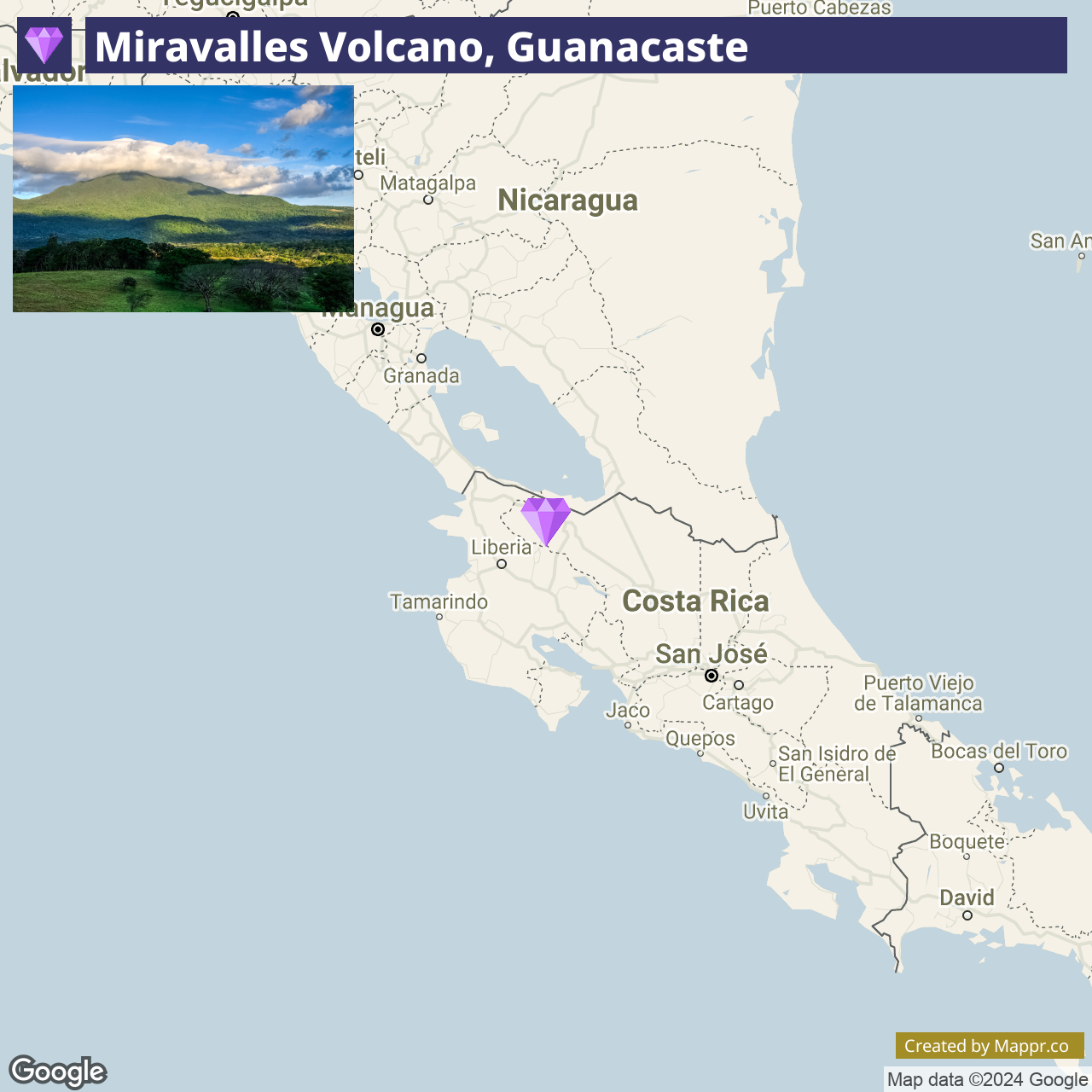
18. Miravalles Volcano, Guanacaste

Miravalles Volcano is the highest peak in the Guanacaste province and part of a protected area that offers visitors a variety of geothermal activities, including hot springs, mud baths, and steam vents.
The surrounding forested areas are ideal for hiking, horseback riding, and bird watching, with trails leading to stunning waterfalls and panoramic Guanacaste plains.
The volcano’s gentle slopes and accessible geothermal sites make it an excellent destination for those interested in volcanic activity and the natural beauty of Costa Rica’s lesser-known regions.
- ✈️ How to Get There: The volcano is accessible from Liberia, with a drive that takes you through the picturesque landscapes of Guanacaste. The region’s well-maintained roads make it an easy and enjoyable trip.
- 🏨 Where to Stay: Accommodations near Miravalles Volcano include the rustic and cozy La Anita Rainforest Ranch, offering a close connection to nature and sustainable agricultural practices, and the more luxurious Colinas del Miravalles Hotel, known for its hot springs and stunning volcano views.
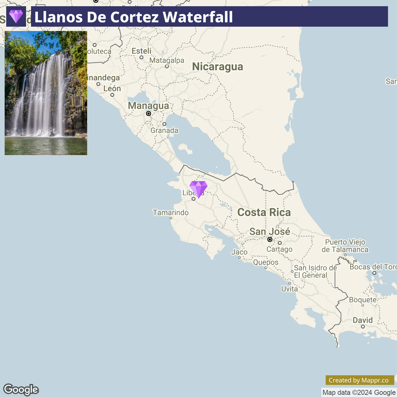
19. Llanos de Cortez Waterfall

Llanos de Cortez Waterfall is a hidden oasis in Guanacaste, featuring a stunning water curtain cascading into a tranquil, sandy-bottomed pool, perfect for swimming and relaxation.
Surrounded by lush vegetation, this easily accessible waterfall offers a picturesque and serene getaway, ideal for families, photographers, and nature lovers.
With its rich biodiversity, the area around the waterfall provides opportunities for wildlife spotting, including various bird species and monkeys.
- ✈️ How to Get There: The waterfall is located near Bagaces and is easily reachable by car from Liberia, making it an excellent detour or half-day trip for those exploring the Guanacaste region.
- 🏨 Where to Stay: Accommodations in nearby Liberia range from the comfortable and convenient Hilton Garden Inn Liberia Airport to the more rustic and nature-immersive Hostalito El Greco, offering adventure activities near the Llanos de Cortez waterfall.
20. Carate, Osa Peninsula

Carate is a remote outpost on the Osa Peninsula, serving as a gateway to the pristine Corcovado National Park. Known for its rugged beauty,
Carate offers miles of untouched beaches backed by dense rainforests, providing a truly off-the-grid experience for those looking to escape into nature.
The area is teeming with wildlife, from scarlet macaws to tapirs, making it a paradise for eco-tourists and adventurers seeking an intimate encounter with Costa Rica’s rich biodiversity.
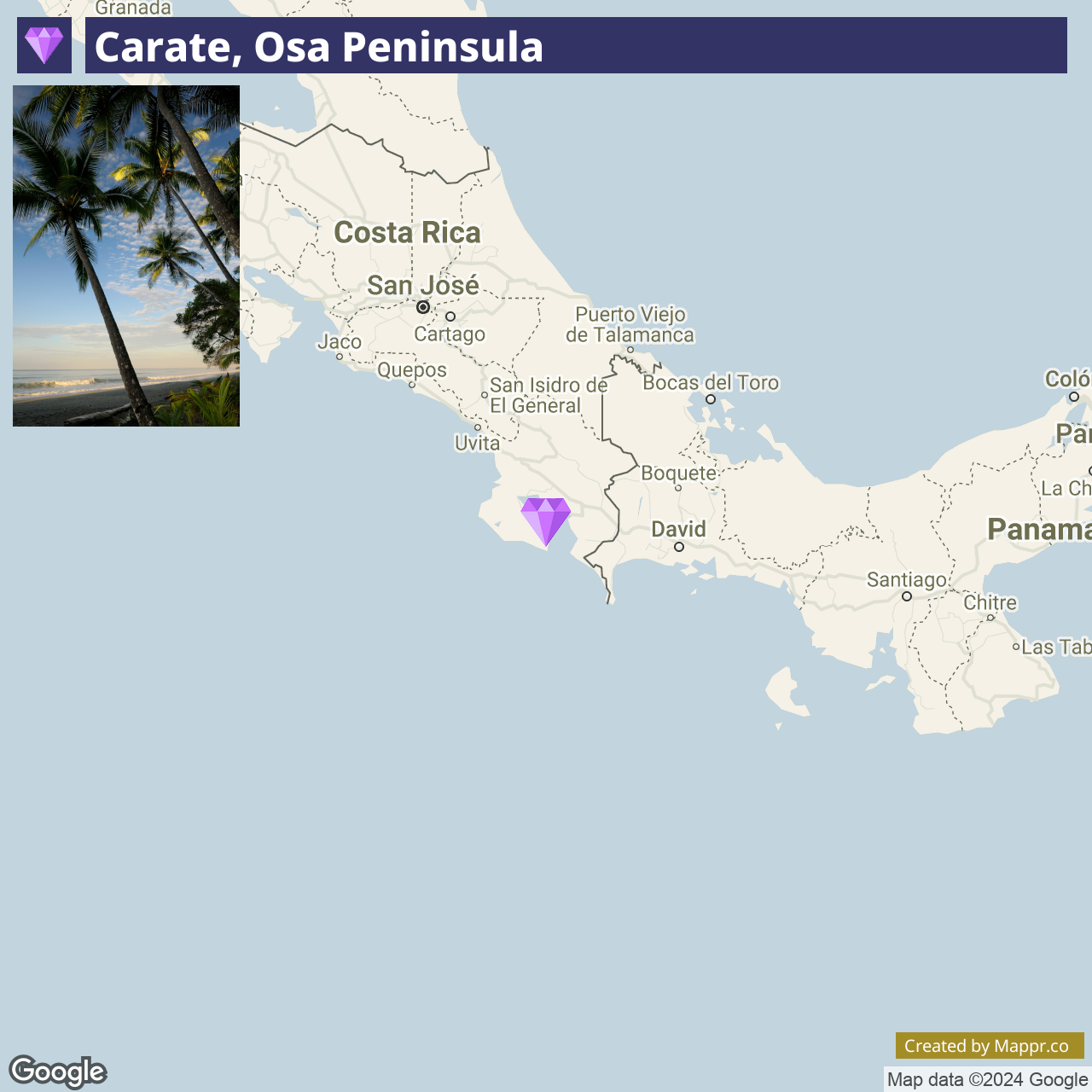
- ✈️ How to Get There: Carate is accessible by 4×4 vehicle from Puerto Jiménez, a journey that takes you through some of the Osa Peninsula’s most scenic landscapes.
- 🏨 Where to Stay: Options in Carate include the Luna Lodge, a secluded eco-lodge offering breathtaking views and a serene setting, or the luxurious Carate Beach Resort, which provides direct access to the beach and rainforest.
21. Playa de Matapalo

Playa de Matapalo is a serene and picturesque beach located on the Central Pacific coast of Costa Rica, known for its expansive sandy shores and peaceful ambiance.
This hidden gem is perfect for those seeking to escape the crowds and enjoy beachcombing, horseback riding along the coast, and watching breathtaking sunsets. The surrounding area offers natural beauty and local culture, with nearby rainforests and small Costa Rican communities.
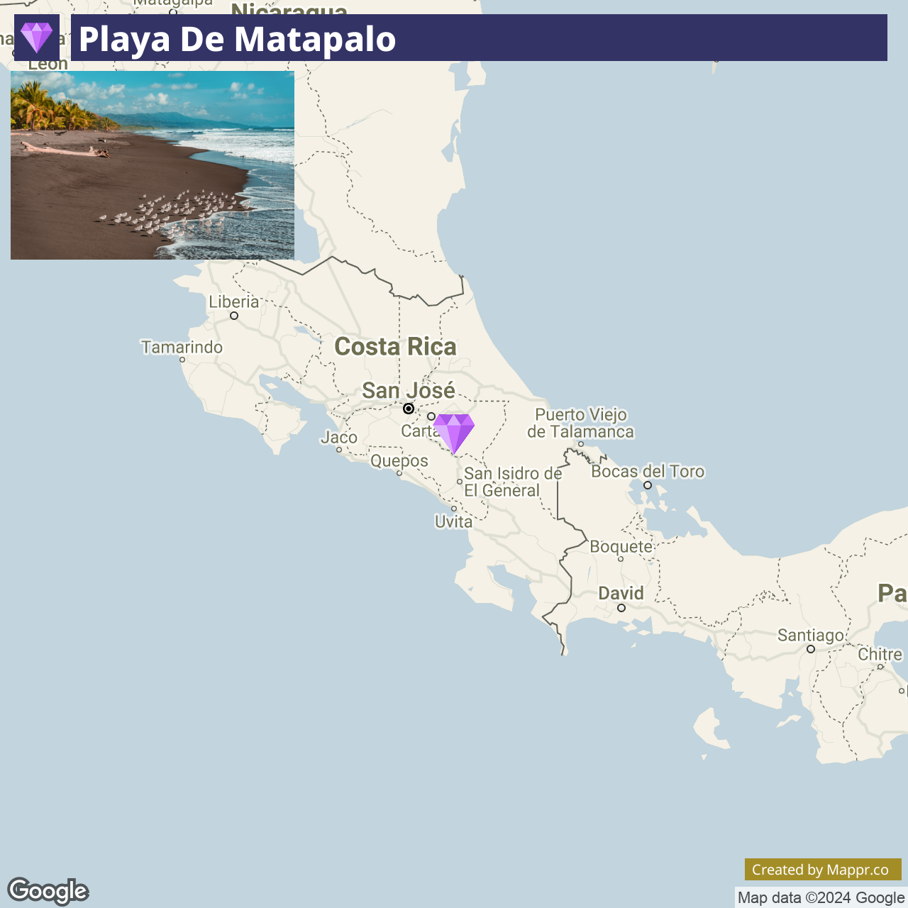
- ✈️ How to Get There: Playa de Matapalo is accessible by car from Quepos or Dominical, with the drive offering scenic views of the coast and countryside.
- 🏨 Where to Stay: Accommodations near Playa de Matapalo range from the tranquil Dreamy Contentment, offering beachfront bungalows, to the more upscale Riu Palace Costa Rica, known for its stunning ocean views and lush gardens.
22. Caño Negro Wildlife Refuge

Caño Negro Wildlife Refuge is a wetland sanctuary in northern Alajuela, renowned for its rich biodiversity and as a haven for birdwatchers.
This remote area becomes a labyrinth of waterways during the rainy season, attracting various migratory and resident birds, including the elusive jabiru stork.
The refuge’s diverse ecosystems also support a variety of other wildlife, such as caimans, turtles, and monkeys, making it a vital area for conservation and a must-visit destination for nature enthusiasts.
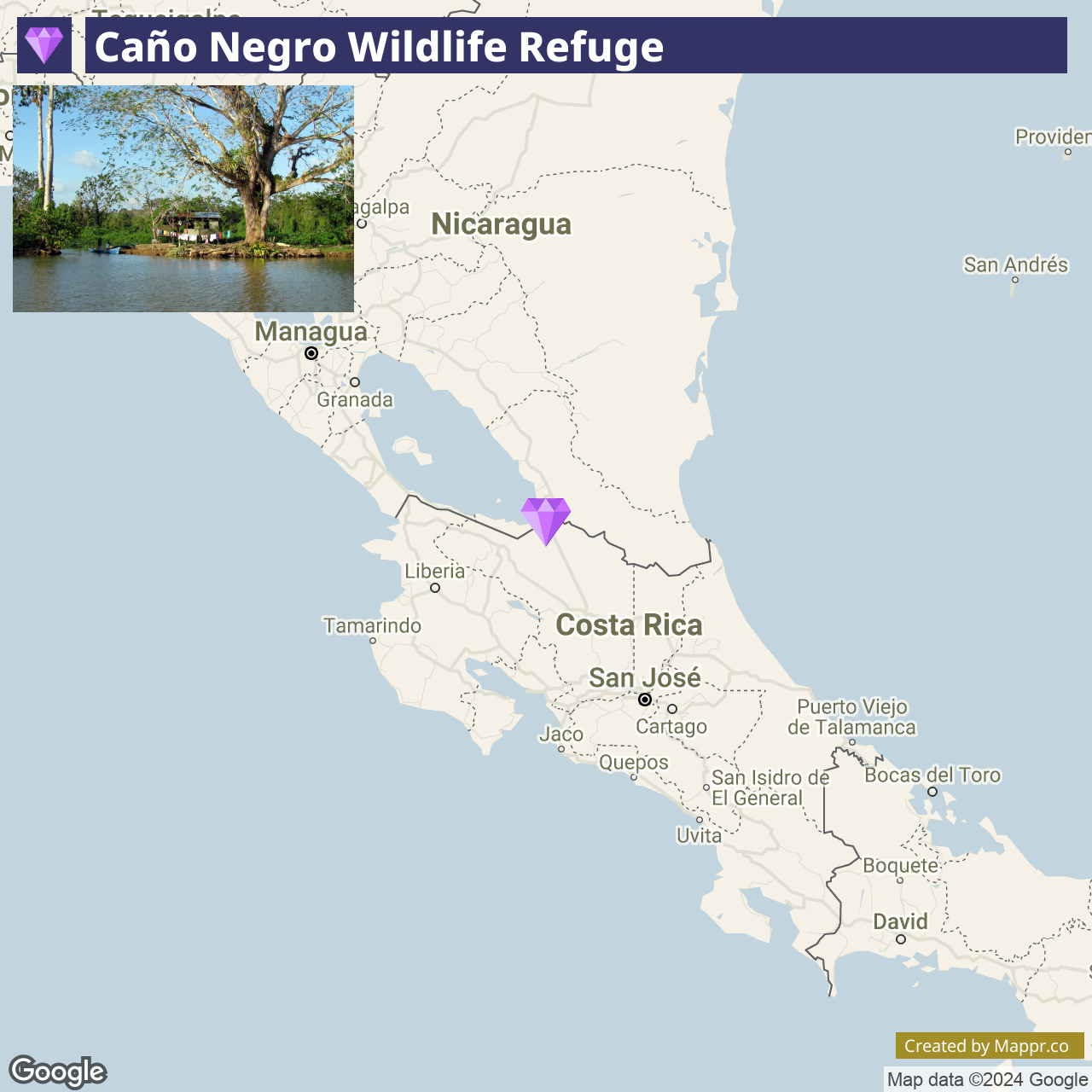
- ✈️ How to Get There: The refuge is most accessible from Los Chiles by car or guided tour. The journey from San José or La Fortuna offers scenic views of the Costa Rican countryside and volcanic landscapes.
- 🏨 Where to Stay: Right outside the Wildlife Refuge, travelers can opt for the Hotel de Campo Caño Negro, which offers cozy accommodations and organized excursions into the refuge. Alternatively, the Posada Rural Oasis presents a more quaint and charming experience.
23. Cerro Chirripó, San José

Cerro Chirripó is Costa Rica’s highest peak, located in Chirripó National Park in the province of San José. The challenging trek to the summit appeals to avid hikers and adventure seekers, offering rewarding panoramic views that span from the Pacific to the Atlantic on clear days.
The park’s diverse ecosystems range from tropical rainforests to high-altitude páramo. The climb to Cerro Chirripó is not only a physical journey but also a spiritual one, offering moments of introspection amidst the breathtaking beauty of nature.
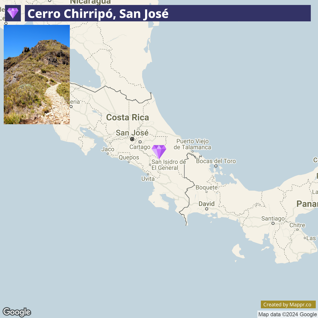
- ✈️ How to Get There: The gateway to Cerro Chirripó is the town of San Gerardo de Rivas, accessible by car or bus from San José. The trailhead to the summit begins here, with hikers often staying in the town the night before their ascent.
- 🏨 Where to Stay: In San Gerardo de Rivas, accommodations such as the cozy and welcoming Jardines Secretos cater to hikers with comfortable lodging. Alternatively, the Talamanca Nature Reserve offers a quaint and friendly base with stunning views of the surrounding mountains.
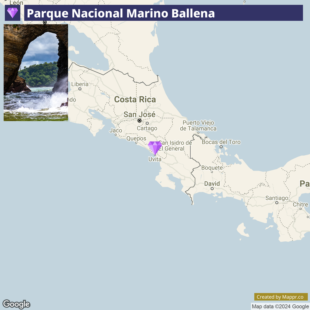
24. Parque Nacional Marino Ballena

Marino Ballena National Park is a marine park located in the South Pacific region of Costa Rica, celebrated for its unique formation known as the Whale Tail. This natural sandbar resembles a whale’s tail.
The park is a prime spot for whale watching, especially humpback whales, which visit the warm waters to mate and give birth. Visitors can also enjoy snorkeling, diving to explore the vibrant coral reefs, and kayaking through the clear waters.
- ✈️ How to Get There: The park is accessible from Uvita, with the nearest domestic airport in Quepos. The drive from San José to Uvita offers a scenic route through the mountains and coastline.
- 🏨 Where to Stay: Nearby Uvita offers a variety of accommodations, such as the rustic-chic Oxygen Jungle Villas & Spa, nestled in the rainforest with ocean views, or the family-friendly La Cusinga Eco Lodge, offering direct access to private trails and beaches within the park.
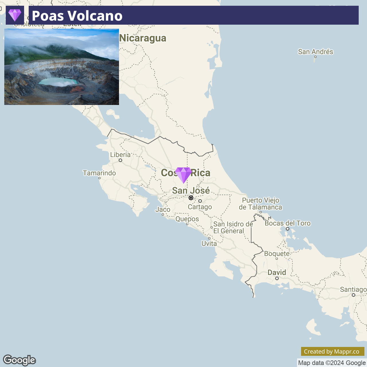
25. Poas Volcano

Poas Volcano is one of Costa Rica’s most active volcanoes, featuring one of the largest accessible crater lakes in the world.
The national park surrounding the volcano offers a variety of ecosystems, from cloud forests to unique high-altitude vegetation.
Visitors can explore the park’s trails, which offer views of the crater, its sulfurous, turquoise lake, and the rich biodiversity of the surrounding cloud forest.
- ✈️ How to Get There: Poas Volcano National Park is located a short drive from San José, making it an accessible day trip for those staying in the capital.
- 🏨 Where to Stay: The nearby Alajuela offers options like the peaceful Poas Lodge, known for its stunning volcano views, or the more luxurious Xandari Resort & Spa, set within a coffee plantation and offering expansive views of the Central Valley.
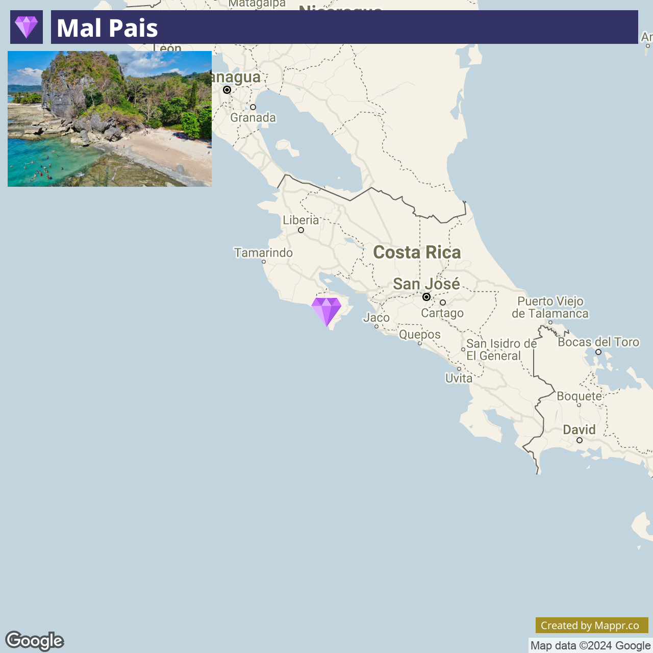
26. Mal Pais

Mal Pais is known for its spectacular surf, bohemian vibe, and stunning sunsets. It’s become a haven for surfers, yogis, and nature lovers, offering a laid-back lifestyle and a strong sense of community.
The area’s rugged natural beauty, combined with a growing selection of boutique accommodations, international cuisine, and wellness retreats, makes it a perfect destination for adventure and relaxation in a paradisiacal setting.
- ✈️ How to Get There: Mal Pais is accessible via a ferry from Puntarenas to Paquera. Alternatively, domestic flights to the nearby Tambor Airport offer a quicker route, followed by a short drive.
- 🏨 Where to Stay: The luxurious Paradise Beach Lodge offers beachfront accommodations and services, and for a more laid-back experience, try Nicoya Villas, known for its friendly atmosphere and surf packages.
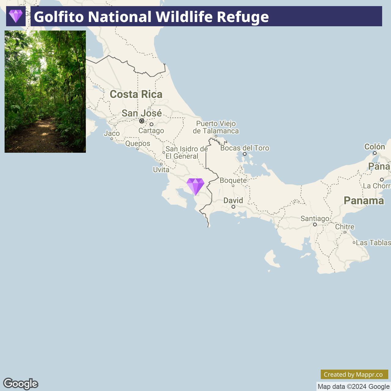
27. Golfito National Wildlife Refuge

The Golfito National Wildlife Refuge, located in the southern part of Costa Rica, is a protected area that encompasses a variety of ecosystems, from lush rainforests to mangrove swamps.
This refuge is a haven for wildlife, including monkeys, sloths, and numerous bird species, making it an excellent spot for nature enthusiasts and birdwatchers.
The area also serves as a gateway to the pristine beaches and untouched nature of the Osa Peninsula, offering a peaceful retreat away from the more tourist-heavy destinations.
- ✈️ How to Get There: Golfito is accessible by car from San José or by domestic flights directly to the town’s airport. The refuge is just a short drive from the town center.
- 🏨 Where to Stay: In Golfito, consider staying at the Banana Bay Marina, offering comfortable accommodations with marina views, or the more secluded Playa Nicuesa Rainforest Lodge, accessible only by boat and offering an immersive jungle experience.
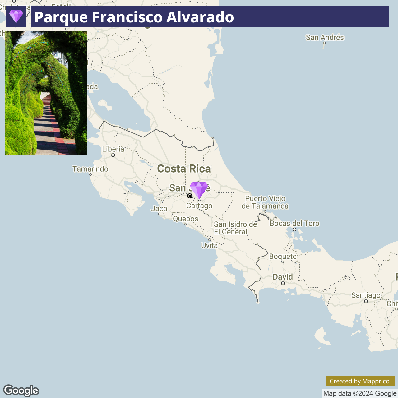
28. Parque Francisco Alvarado

Parque Francisco Alvarado is most famous for its whimsical topiary garden. The park’s meticulously sculpted shrubs and hedges, crafted by local artist Evangelista Blanco since the 1960s, create a surreal landscape that captivates visitors of all ages.
The park in front of the San Rafael Church adds to Zarcero’s charm. This unique artistic expression, set against the backdrop of a traditional Costa Rican town, offers a delightful blend of culture, art, and community.
- ✈️ How to Get There: Zarcero is easily accessible by car or bus from San José, with the drive taking you through the scenic Costa Rican countryside.
- 🏨 Where to Stay: Rancho Amalia provides comfortable accommodations with picturesque views of Naranjo, while Hospedaje Alto Lechuza Zarcero provides a more traditional experience near the Francisco Alvarado Parque.
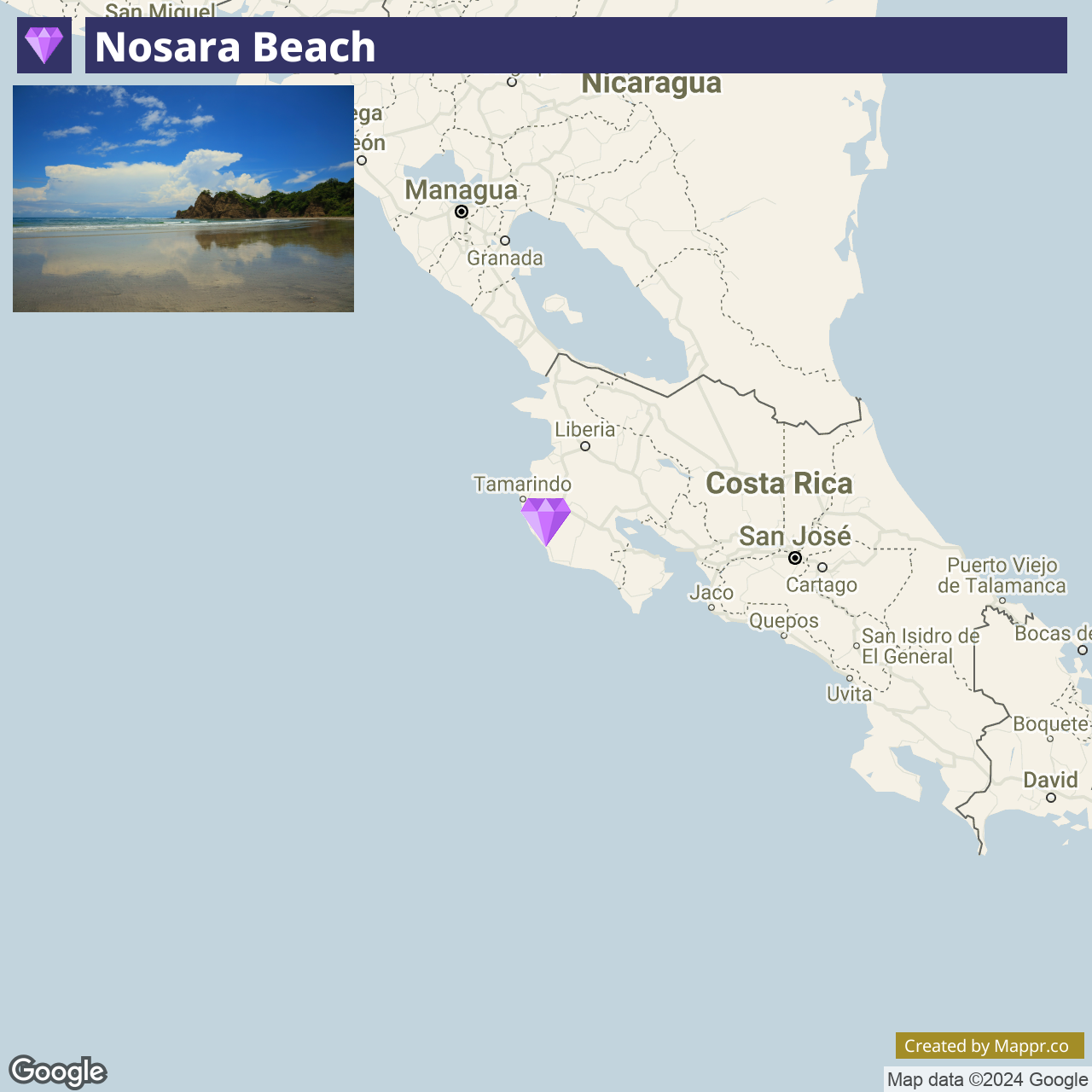
29. Nosara Beach

Nosara Beach is renowned for its world-class surf, stunning natural beauty, and commitment to environmental preservation. The area, including the beaches of Guiones and Pelada, offers a unique blend of laid-back culture and upscale wellness retreats.
Nosara has become a yoga and holistic health hub, with various studios and wellness centers catering to visitors. The region’s protected turtle nesting sites and efforts to maintain a sustainable community add to its appeal as a destination for eco-conscious travelers.
- ✈️ How to Get There: Nosara is accessible by car from Nicoya or domestic flights to the Nosara Airport. The journey offers a glimpse into the rural and coastal beauty of the Nicoya Peninsula.
- 🏨 Where to Stay: Accommodations in Nosara cater to a range of preferences, from the luxurious Bodhi Tree Yoga Resort, ideal for those seeking a wellness-focused retreat, to the laid-back Surf, offering comprehensive surf coaching and accommodation packages.
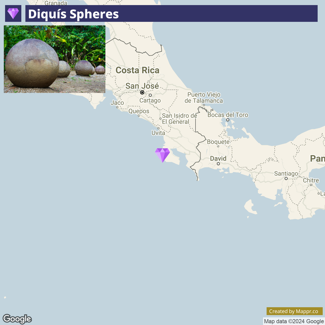
30. Diquís Spheres

The Diquís Spheres are a collection of over 300 pre-Columbian stone spheres, found in the Diquís Delta of southern Costa Rica. These mysterious and perfectly round spheres range in size and are thought to have been crafted between 600 and 1500 CE.
Their purpose and creation method remains a mystery. Recognized as a UNESCO World Heritage Site, the spheres are a testament to the craftsmanship and cultural heritage of the indigenous peoples of Costa Rica. They can be seen in museums and public spaces across the country.
- ✈️ How to Get There: To explore the regions where the spheres are originally found, travelers can head to the southern part of Costa Rica, particularly around Palmar Sur and Sierpe.
- 🏨 Where to Stay: For those exploring the Diquís Delta’s ancient spheres, La Muñequita Lodge 2 offers a unique blend of cultural immersion and nature exploration. Alternatively, the Valles of Osa presents a tranquil retreat amidst the lush surroundings.
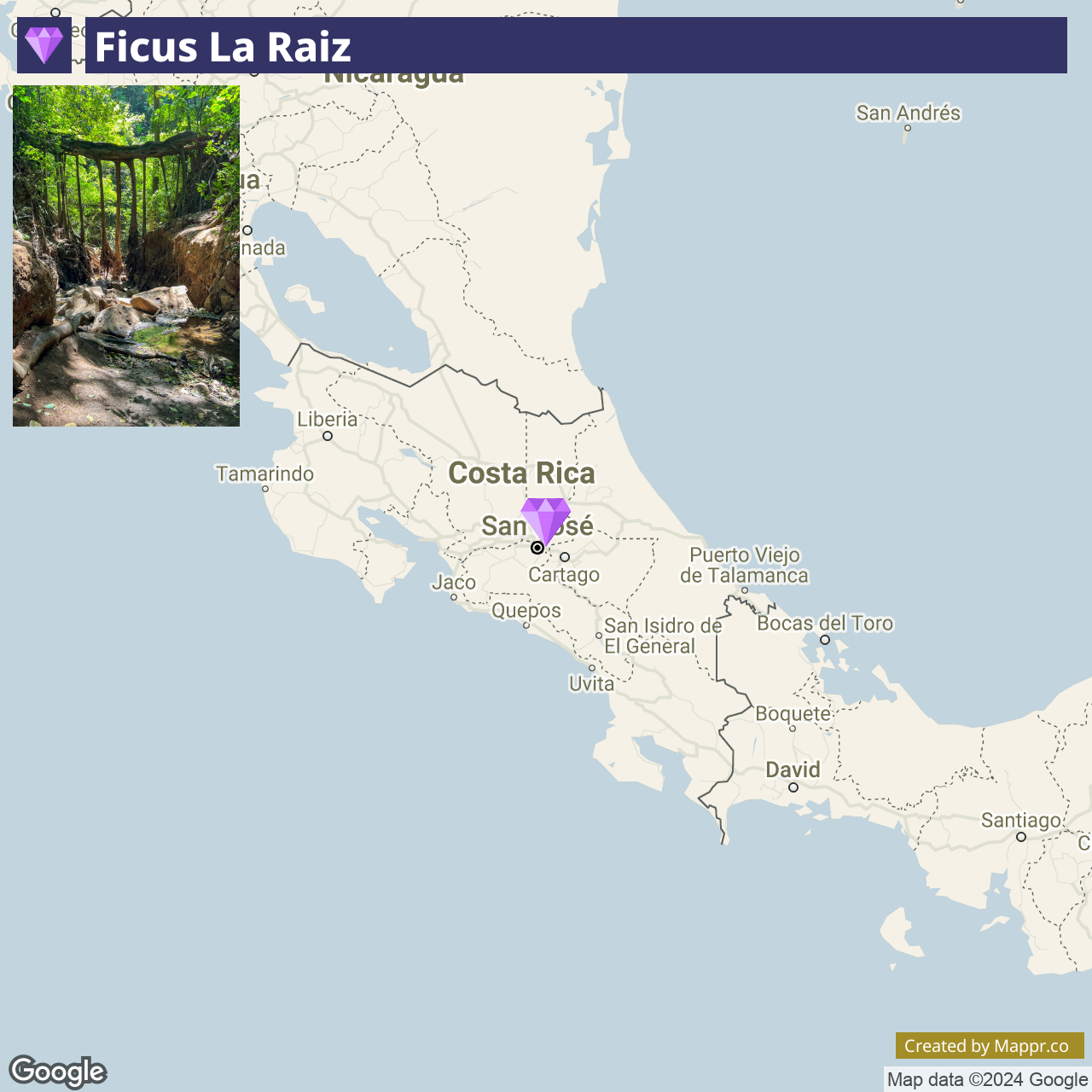
31. Ficus la Raiz

Ficus la Rai is a natural wonder in Monteverde, Costa Rica. This living bridge was formed by the intertwining roots of Ficus trees, creating a tunnel-like structure visitors can walk through.
The formation is a stunning example of the adaptability and beauty of nature, offering a unique photo opportunity and a moment of wonder in the heart of the cloud forest.
The surrounding area of Monteverde is renowned for its biodiversity, making Ficus la Raiz just one of many natural attractions in the region.
- ✈️ How to Get There: Monteverde is accessible by car or bus from San José or the Guanacaste region. The Ficus la Raiz is located just outside the main town of Santa Elena, within walking distance or a short drive from the town center.
- 🏨 Where to Stay: Monteverde offers a variety of accommodations, from the luxurious Monteverde Lodge & Gardens, known for its cloud forest setting, to the more budget-friendly Cabinas El Pueblo, offering a cozy and friendly base for exploring the area’s natural wonders.
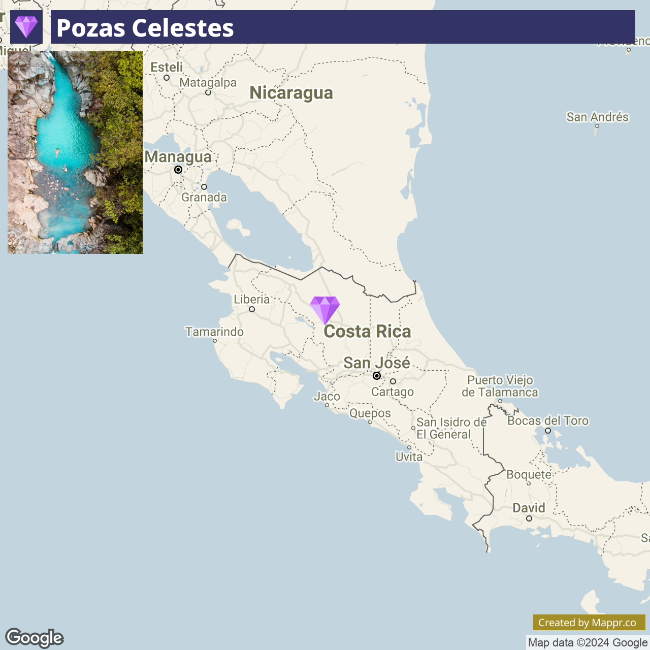
32. Pozas Celestes

Pozas Celestes, translating to “Celestial Pools,” is a hidden natural wonder located in the Dota region of Costa Rica. These stunning turquoise pools and waterfalls are part of a lesser-known river system set amidst a lush cloud forest.
The vibrant blue hue of the water, created by natural minerals and the reflection of the sky, offers a mesmerizing and tranquil setting ideal for nature lovers and photographers.
The journey to Pozas Celestes involves a hike through scenic trails, providing an immersive experience in Costa Rica’s breathtaking natural beauty and biodiversity.
- ✈️ How to Get There: The pools are accessible from San José, with a drive through the picturesque mountains of the Dota region. The final stretch to the pools requires a hike.
- 🏨 Where to Stay: Consider the El Silencio Lodge & Spa for a luxurious escape into the heart of the cloud forest, where elegant suites and private villas blend seamlessly. Alternatively, Hotel Finca 360 offers stunning 360-degree views of the surrounding landscapes.
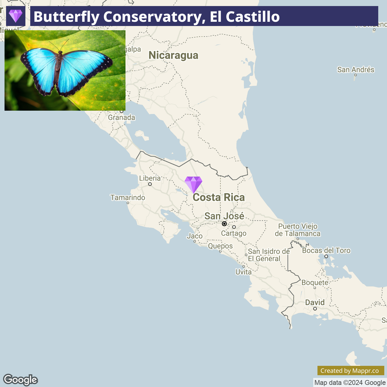
33. Butterfly Conservatory, El Castillo

The Butterfly Conservatory in El Castillo is a magical destination nestled near the Arenal Volcano. This sanctuary is home to diverse butterfly species, showcasing the vibrant colors and patterns of Costa Rica’s insect life in a carefully maintained habitat.
Visitors can wander through the lush gardens and enclosed habitats, witnessing the life cycle of butterflies and learning about their importance to the ecosystem.
The sanctuary also offers stunning views of the surrounding landscapes, including the imposing Arenal Volcano, making it a peaceful and educational experience for all ages.
- ✈️ How to Get There: El Castillo is accessible by car from La Fortuna, the nearest major tourist hub. The scenic drive around Lake Arenal offers panoramic views and leads you to this quaint village and its attractions.
- 🏨 Where to Stay: In El Castillo, Vulkan Arenal Amazing View Lodge presents an exceptional lodging experience with unparalleled views of the Arenal Volcano. Alternatively, Pie in the Sky 2 Luxury Home elevates the stay with its high-end amenities and stunning vistas, ensuring a luxurious and tranquil environment.
Final Thoughts
Exploring Costa Rica’s hidden gems reveals the heart of its charm, especially in summer. These off-the-beaten-path experiences provide a unique blend of tranquility, adventure, and cultural immersion, making your journey truly memorable. Venture beyond the common to discover the extraordinary in Costa Rica.


- Hidden Gems Costa Rica — © Mappr
- Tropical Waterfall and Pool — © Juhku/Shutterstock
- Sunny Beach with Blue Skies and Clouds — © Lauren Squire/Shutterstock
- Tropical Waterfall Oasis — © Thijs Peters/Shutterstock
- Tropical Waterfall and Blue River — © Vadim 777/Shutterstock
- Stream Flowing Through a Lush Forest — © Marco Diaz Segura/Shutterstock
- Tropical Beach with Palm Trees and Waves — © Rainer Lesniewski/Shutterstock
- Tropical Waterfall and Rocks — © Gianfranco Vivi/Shutterstock
- Tropical Beach with Palm Tree — © Adolfo Lopez Perez/Shutterstock
- Tropical Beach and Forested Coastline — © Duarte Dellarole/Shutterstock
- Tropical Beach with Lush Greenery — © Simon Dannhauer/Shutterstock
- Stream Flowing Through Bajos del Toro Cloud Forest — © William Berry/Shutterstock
- Suspension Bridge in Lush Forest — © Miss Nephew/Shutterstock
- Tropical Beach with Lush Greenery and Clear Blue Sky — © boivin nicolas/Shutterstock
- Serene Beach with Trees and Mountains in the Distance — © Marco Diaz Segura/Shutterstock
- Twisted Tree Roots in Forest — © Tonocb/Shutterstock
- Tropical Beach View through Forest — © Julen Arabaolaza/Shutterstock
- Sandy Beach with Driftwood in Costa Rica — © Kristy S/Shutterstock
- Miravalles Volcano Landscape — © David Boutin/Shutterstock
- Tropical Waterfall Cascade — © John Fader/Shutterstock
- Tropical Beach at Sunrise with Palm Trees — © Reimar/Shutterstock
- Tropical Beach with Birds and Driftwood — © Maridav/Shutterstock
- Boat Near Riverside House in Cano Negro Wildlife Refuge — © David Berkowitz/Flickr
- Rocky Mountain Trail Leading Upwards — © Adriana Margarita Larios Arellano/Shutterstock
- Natural Rock Arch Over Ocean Waves — © Jakub Maculewicz/Shutterstock
- Poas Volcano Crater with Mist — © Olaf Speier/Shutterstock
- Tropical Beach with Rocky Outcrop and Swimmers — © Joshua ten Brink/Shutterstock
- Dense Tropical Rainforest Pathway — © Adolfo Lopez Perez/Shutterstock
- Topiary Garden Pathway — © Galyna Andrushko/Shutterstock
- Tropical Beach with Blue Sky and Cloud Reflections — © Larry Satterberg/Shutterstock
- Pre-Columbian Stone Spheres in Costa Rica — © Inspired By Maps/Shutterstock
- Wooden Bridge Over Forest Stream — © Erica Ruth Neubauer/Shutterstock
- Aerial View of Turquoise Natural Pool in Forest — © Maximilian Stimmel/Shutterstock
- Blue Butterfly on Green Leaf — © SL-Photography/Shutterstock