The flag of Trinidad and Tobago embodies the nation’s character and values, serving as a testament to its cultural diversity and enduring strength. It symbolizes the country’s journey through challenges and achievements, capturing the essence of its people’s resolve and collective spirit.
Flag of Trinidad and Tobago
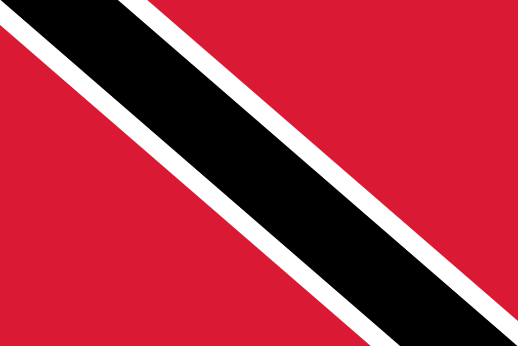
The flag of Trinidad and Tobago, characterized by its dynamic diagonal stripe, mirrors the geographical and cultural essence of the nation, nestled at the southernmost edge of the Caribbean, close to South America.
The flag’s striking geometry and vivid colors not only symbolize national pride but also reflect the country’s rich natural and cultural landscapes, from the lush Northern Range in Trinidad to the serene beaches of Tobago.
Its design is a declaration of sovereignty, a globally recognized emblem of the nation’s uniqueness, and the rich mosaic of life that flourishes within this island country.
Flag of Trinidad and Tobago: Color Palette
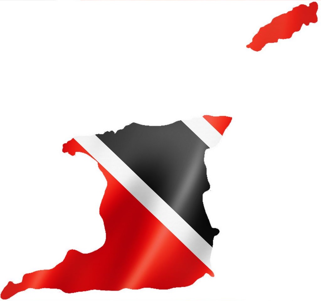
Trinidad and Tobago Flag Map
Trinidad and Tobago Flag Emoji: 🇹🇹
The color palette of the Trinidad and Tobago flag is carefully chosen, each hue holding deep significance. These colors combine to form a vibrant and meaningful display, creating a deeper exploration of their symbolism and the collective message they convey about the nation.
Meaning of Each Color

Red
The vibrant red symbolizes the sun’s energy, reflecting the courage and vitality of the people. It represents Trinidad and Tobago’s warmth and dynamism, embodying the nation’s spirit and natural beauty.
The red is a tribute to the life-giving force of the sun and the boundless energy it provides, underscoring the country’s forward-moving, courageous ethos.
Black
Black denotes the land’s wealth and the dedication and hard work of the people. It stands for the earth itself, from which the nation draws its strength and resources.
This color embodies the resilience and determination of the citizens, highlighting their commitment to building a prosperous and enduring nation.
Black in the flag encapsulates its citizens’ unity and solidarity, connection to the land, and collective effort toward national progress.
White
White represents the surrounding sea, symbolizing purity, equality, and the aspiration for peace and harmony within the country.
It signifies the nation’s ideals of justice and equality, the peaceful coexistence of its diverse population, and the clear vision and high ideals that guide the nation’s path.
The white bands framing the black diagonal embody the nation’s commitment to maintaining balance and fairness in its journey forward.
Trinidad and Tobago’s Coat of Arms
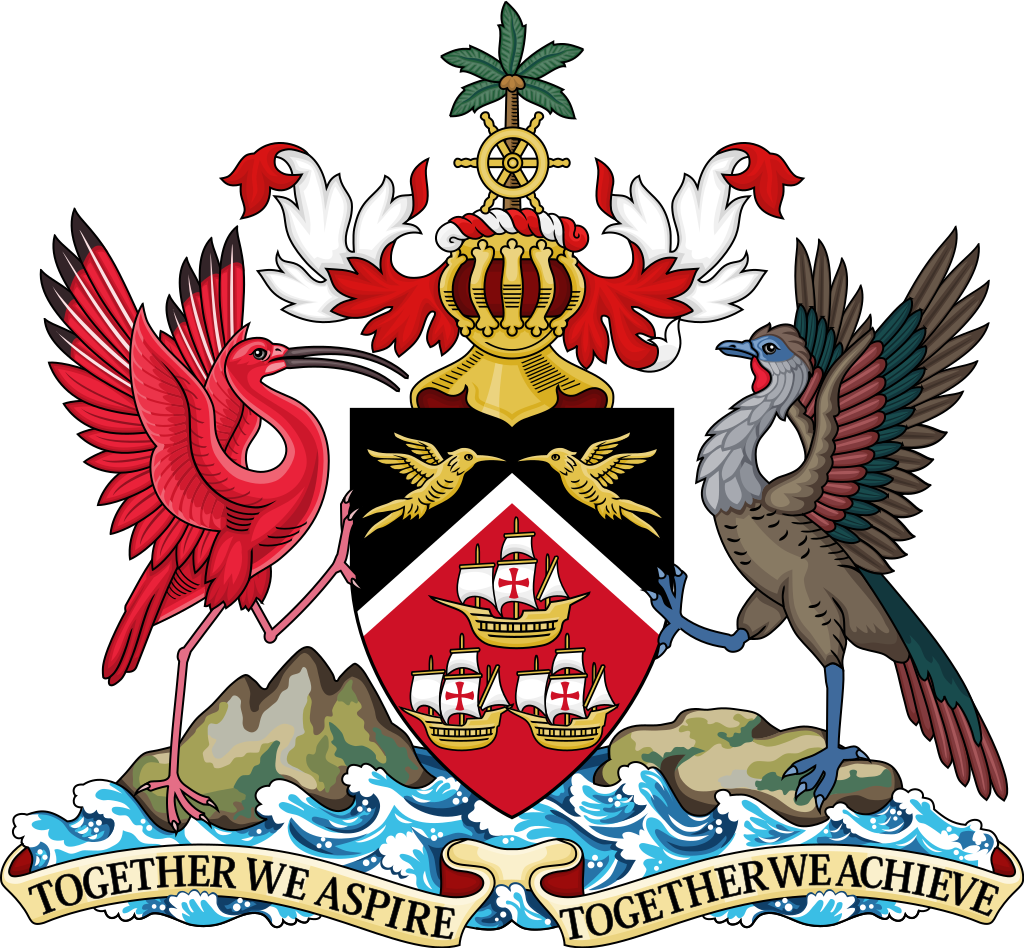
The Coat of Arms of Trinidad and Tobago, adopted in 1962, is rich in symbolism and reflects the nation’s history, culture, and natural environment. The design includes:
- Shield: The shield carries the colors of the national flag, with each color retaining its symbolic meaning. Within the shield, three gold ships represent Christopher Columbus’s vessels—the Santa Maria, La Nina, and La Pinta—highlighting the historical European exploration and its impact on the region.
- Hummingbirds: Two hummingbirds are depicted in the black section above the ships, representing the diverse species found on the islands, particularly in Trinidad. These birds symbolize the island’s rich biodiversity and natural beauty.
- Supporters: The shield is supported by the Scarlet Ibis (the national bird of Trinidad) on the left and the Cocrico (the national bird of Tobago) on the right. These birds stand for the distinct identities of the two islands while also symbolizing the nation’s unity.
- Helm and Crest: A golden helmet faces forward at the top of the Coat of Arms, above which sits a crest featuring a ship’s wheel and a coconut palm. This combination highlights the importance of maritime navigation in the country’s history and the tropical character of its landscape.
- Motto: The national motto, “Together We Aspire, Together We Achieve,” is displayed on a scroll at the bottom of the Coat of Arms. It encapsulates the core values of unity, ambition, and collective achievement that define the nation’s spirit.
These elements combine to form a Coat of Arms that celebrates the country’s heritage and natural wonders and conveys the aspirations and values that guide its people.
Historical Evolution and the Meaning Behind Changes
With its distinctive colors and design, the Trinidad and Tobago flag was officially adopted upon the country’s independence from the United Kingdom on August 31, 1962.
The design, conceived by Carlisle Chang, a renowned artist, was chosen by the independence committee to symbolize the dawn of a new era.
The flag’s original colors—red, black, and white—have remained consistent since its adoption, with each hue carrying deep symbolic meanings tied to the Trinidad and Tobago.
Before this current flag, Trinidad and Tobago, as a colony of the UK, used flags that bore the Union Jack, reflecting its colonial status. These flags often featured a blue or red field with the Union Jack in the upper left corner and a specific emblem or badge on the right side.
The transition to the current flag marked a significant shift from colonial representation to independence. Choosing a completely new design and color scheme was a deliberate move to break away from colonial ties and craft a unique national identity.
The red, black, and white were chosen for their powerful symbolism, representing the vitality of the land and people (red), the wealth of the earth and the dedication of its citizens (black), and the surrounding sea and the nation’s aspirations for equality and harmony (white).
This evolution from colonial flags to national flags reflects the country’s journey towards self-determination and independence.
Overall Symbolic Meaning of the Flag
The flag of Trinidad and Tobago embodies the nation’s historical path, spirit, and collective desires for a better future. It symbolizes its people’s unity and strength, connection to the land, and collective pursuit of progress and harmony.
This emblem is a testament to the country’s resilience, diverse cultural heritage, and commitment to forging a prosperous and equitable future.
Similar Flags to the Flag of Trinidad and Tobago
The flag of Trinidad and Tobago, characterized by its distinctive diagonal stripe, shares similarities with the flags of several other countries due to its unique geometric design rather than shared history or cultural exchanges. Some examples include:
Democratic Republic of the Congo (DRC)
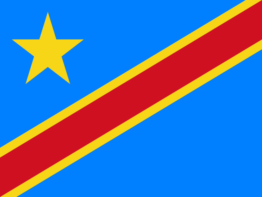
The DRC’s flag has a sky-blue field and a red diagonal stripe with a thin yellow border. The diagonal stripe is common with Trinidad and Tobago’s flag, although the meanings and color schemes differ significantly.
The inclusion of a diagonal stripe in the DRC’s flag represents a visual departure from more traditional horizontal or vertical designs, offering a dynamic expression similar to that of Trinidad and Tobago’s flag despite the distinct contexts and stories each flag tells.
Tanzania
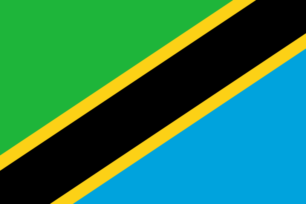
The flag of Tanzania includes diagonal bands in green, black, yellow, and blue. Using a diagonal stripe is a design similarity, bridging these nations’ geographical and cultural distances.
Tanzania’s flag employs the diagonal stripe to merge various symbolic colors, creating a unified visual narrative that echoes the dynamic and diverse character of Trinidad and Tobago’s flag despite their different cultural backgrounds.
Namibia
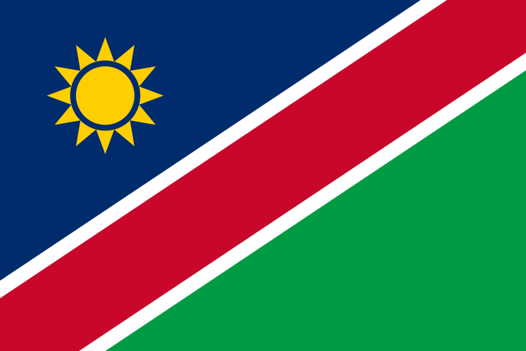
Namibia’s flag features a red diagonal band, bordered by white, that divides the flag into blue and green triangles. The diagonal element creates a visual link to Trinidad and Tobago’s flag.
The diagonal division in Namibia’s flag separates contrasting colors and themes, similar to Trinidad and Tobago’s flag, symbolizing a blend of diverse elements within the nation, much like Trinidad and Tobago’s representation of unity and diversity.
Final Thoughts
The flag of Trinidad and Tobago, with its unique colors and design, holds a special place among the world’s flags, symbolizing the nation’s unity, diversity, and vibrant spirit. It serves as a source of pride and identity for its citizens, reflecting their shared values and aspirations on both a national and global stage.


- Trinidad and Tobago Flag in Front of White Hall Building — © maloff/Shutterstock