
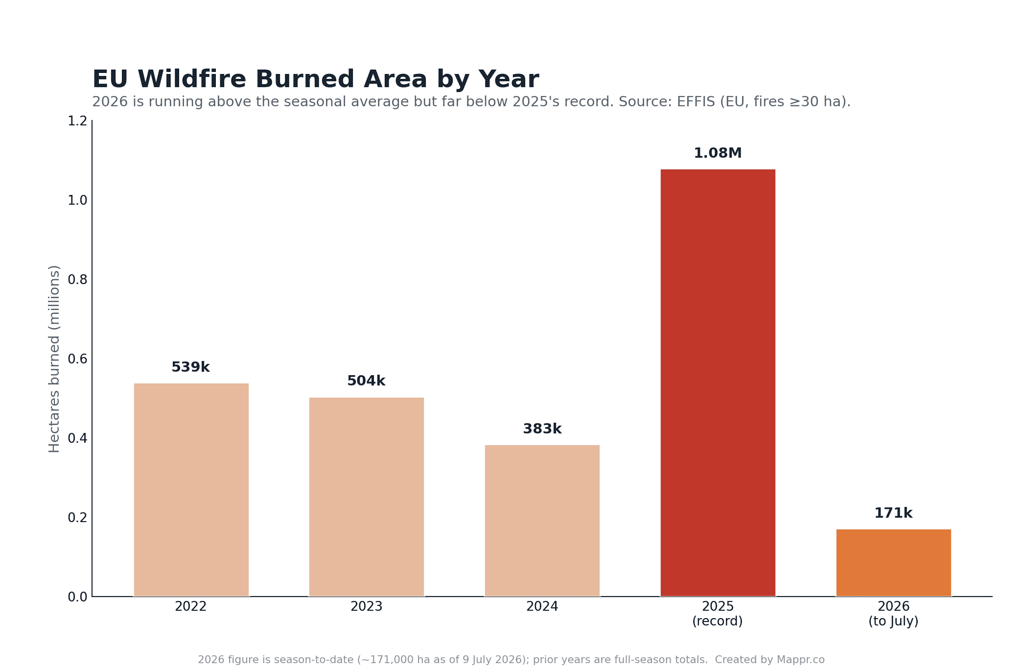
The gap with last year is still wide. EFFIS had mapped 993,870 hectares from 1,980 fires by 1 September 2025, the worst season on record, so 2026 leaves the summer running well below it.
That is a serious season, but a long way short of 2025, which was the EU’s most destructive wildfire year on record: more than 1.08 million hectares burned, with Germany, Spain, Cyprus and Slovakia all setting national records. The chart above shows how the years compare.
How Europe is responding
Europe has mobilised on an unprecedented scale. Through the EU Civil Protection Mechanism, the rescEU fleet has 22 firefighting aeroplanes and 5 helicopters on standby across 12 countries, backed by 777 firefighters pre-positioned in Cyprus, Greece, Italy, France, Spain and Portugal, the largest such deployment since the scheme began in 2022.
As the fires spread, Portugal activated EU assistance on 3 July and France on 5 July, drawing firefighting aircraft from Italy, Spain, Sweden and Cyprus within hours. The EU is also funding a new permanent fleet of a dozen amphibious water bombers, due from 2027, and a new regional firefighting hub in Cyprus. The aim is to move from emergency scrambles toward a standing, shared European response as fire seasons lengthen.
By 26 July the mechanism was moving crews as well as aircraft. Italy had sent 14 emergency personnel and two Canadair water bombers to Spain, Portugal 129 personnel and 41 support vehicles, and Greece 33 personnel with two Canadairs and a support aircraft, while Turkey promised two more planes.
France received five aircraft and two helicopters from the rescEU fleet, and ten Spanish autonomous communities sent reinforcements to the fires west of Madrid.
On 29 July the EU crisis management commissioner, Hadja Lahbib, used the week’s fires to push for a shift from response to prevention. “Climate change is accelerating. So our response must evolve just as quickly,” she said.
“We must prepare for risks before disasters strike and not simply react afterwards,” Lahbib added, calling for more funding, better fire-risk education and stronger forest management across the bloc.
The cross-border traffic kept flowing regardless. Forty forest specialists from Bosnia and Herzegovina joined the Fermoselle fire in Zamora on 31 July, a day after Serbian crews, and two Turkish water bombers had been working it for two days.
More than 100 foreign personnel were on that fire alone, from Serbia, Bosnia, Qatar and Germany. In France, four relief columns from other departments reached the Var on the morning of 1 August.
European ministers went further on 30 July, declaring climate change a national security emergency and warning that wildfires were threatening the continent’s way of life.
The Commission set out the scale of the response on 12 August. The rescEU fleet has 22 firefighting aircraft, 14 amphibious and eight light, plus five helicopters across 12 countries, alongside 15 ground teams and five more with vehicles.
The machinery has been used hard. There have been seven activations of the EU Civil Protection Mechanism since the start of the year and 30 Copernicus emergency mapping activations for wildfires since early June, five of them still running.
| Fire | Location | Key impact |
|---|---|---|
| Los Gallardos | Almería, Spain | 14 dead, deadliest of 2026 |
| Orés | Zaragoza, Spain | ~15,400 ha, contained, 6 villages evacuated |
| La Mierla | Guadalajara, Spain | ~35,000 ha, one of Spain’s largest ever, downgraded to level 1 on 24 July, ~1,200 evacuated from 34 municipalities |
| Pyrénées-Orientales | Southern France | 10,000+ evacuated |
| Gironde / Landes | Bordeaux area, France | ~42,000 ha in Gironde plus 3,600 ha in the Landes, the largest French forest fire since 1949; 2 firefighters killed 21 July, 230 injured in the Gironde by the evening of 29 July; 220,000+ evacuated in Gironde, ~240 houses destroyed (152 at Le Porge) plus 198 buildings near Biscarrosse; declared contained on 1 August after nine days, still at 42,000 ha and not yet fixed; 198,000 of the more than 220,000 evacuated cleared to return by the evening of 31 July, 264 firefighters treated, the A63 reopened and rail south of Bordeaux reopening on 1 August, Landes fire fixed; declared fixed in the 20:00 bulletin on 1 August bar hot spots at Cap Ferret and south of Lacanau, 208,000 cleared to return across 21 of the 23 evacuated communes, more than 330 firefighters injured and 252 buildings destroyed; the last two communes, Lège-Cap-Ferret and Le Porge, were reintegrated on 2 August, completing all 23, though campsites, light dwellings and the Le Ferron and Plein Soleil sectors stay closed pending demining |
| Vouzela | Viseu, Portugal | 11,000+ ha, 620 km smoke plume |
| Les Gavarres | Catalonia, Spain | 2,200 ha, suspect arrested |
| Fthiotida | Central Greece | 2 dead (father and son) |
| Sierra de Espadán | Castellón, Spain | Cork-oak park, evacuations |
| San Cataldo / Madonie | Sicily, Italy | 1 firefighter dead, ~6,000 responders, 23 July |
| Villa del Prado / Burgohondo | Madrid and Ávila, Spain | Merged 24 July, worst in Madrid region’s history; interior ministry gave ~10,000 ha Madrid plus 13,000-15,000 ha Ávila on 25 July, while the largest single fronts were reported as Navaluenga ~22,000 ha and San Martín de Valdeiglesias ~14,500 ha; by 29 July the Madrid, Ávila and Toledo fires covered about 80,000 ha, the Ávila blaze becoming the largest wildfire in Spain’s recorded history at ~50,000 ha; caused by an unlicensed rock-breaking excavator near Burgohondo, operator arrested; declared technically stabilised on 29 July, all Ávila evacuations and road closures lifted, the last Madrid municipalities cleared to return on 30 July, Almorox in Toledo down to level 1 and the national emergency cut from level 3 to operational level 2 on 30 July; the Madrid and Ávila emergency was wound up on 31 July, but Burgohondo flared again on 1 August at La Adrada, with an ES-Alert evacuation of the La Picota urbanisation and the fire back at level 2, joined by 50 personnel from Qatar; on 4 August the Castilla y León forest service put Burgohondo at more than 50,000 ha along a 160 km perimeter, still at level 2 and at least a month from being declared out, with new outbreaks at La Adrada and the El Horcajo dam under investigation as possibly deliberate; declared stabilised on the morning of 6 August after 15 days and cut from severity level 2 to level 1, with 27 units still on the 160 km perimeter, La Adrada’s evacuees home and at least a month to go before it can be declared extinguished |
| Cotignac / Pontevès (Var) | Southeast France | ~4,500 ha and ~25 houses destroyed to 28 July, when the fire was declared fixed at 19:30; the Gros Bessillon restarted about 13:30 on 31 July, ran through ~1,250 ha in a few hours and forced 2,500 people out of Correns, Montfort-sur-Argens, Carcès, Le Val and Châteauvert; 1,300 firefighters, eight Canadairs, two Dash and six helicopters by 1 August, when the préfet said the containment lines had held; mapping on 1 August put the whole fire at close to 6,000 ha, about 1,500 of them since the restart, with 1,500 firefighters and 310 vehicles and about 2,800 evacuated; perimeter held overnight into 2 August, Correns centre and northern Le Val released; about 1,850 ha burned since the 31 July restart, 70 homes hit and 41 destroyed, 225 drops on 2 August and Correns fully reintegrated that evening; no restart overnight into the 09:00 bulletin on 3 August, with 1,500 firefighters and 120 gendarmes on 270 km of perimeter and the RD45, RD22 and RD554 closed; still not fixed on 5 August, when the 09:30 bulletin cut the deployment to 800 firefighters and 250 vehicles after an overnight flare-up near Correns was held, with the RD22 and RD554 closed and fuel-can transport banned across the Var to 8 August; still not fixed in the prefecture’s 20:00 bulletin on 6 August, with 850 firefighters, two Canadairs at Hyères, a Dash and water-bombing helicopters holding reactivations at Vallon Sourn and Brignoles, the RD22, RD45 and RD562 closed and about 500 police checks made on the fuel and lighter ban; declared fixed at 19:30 on 7 August after 18 days, the longest fire in the history of the Var fire service, with 6,300 ha run through and 5,700 ha burned across Pontevès, Correns, Cotignac, Carcès, Montfort-sur-Argens, Châteauvert and Barjols, 70 homes hit and 41 destroyed, about 6,000 people evacuated and 450 firefighters left on site |
| Vall d’Uixó | Castellón, Spain | 9,598 ha since 25 July along a perimeter of more than 82 km, declared stabilised on 31 July after seven days, at 9,568 ha along an 89 km perimeter on the stabilisation count; ~6,000 residents home by 30 July, 1,800 more from Alfondeguilla, Chóvar and Sueras on 31 July, then Artana and Eslida as the alert dropped to situation 1 |
| Manises | Valencia, Spain | 1 dead (78-year-old man), fire later controlled, two days of mourning |
| Corte | Corsica, France | 800+ ha |
| Rethymno | Crete, Greece | 2 firefighters killed 29 July; about 8,000 evacuated overnight into 30 July from Agia Galini, Agios Pavlos and Triopetra, front over 15 km, winds to 102 km/h grounded aircraft, 200+ firefighters and 53 engines |
| Peloponnese | Southern Greece | 1 firefighter killed 29 July in a separate fire |
| Seydikemer | Muğla, Turkey | Hospital units evacuated 29 July and 45 patients moved; 408 homes cleared and 703 people plus ~100 animals out, 55 buildings damaged across six neighbourhoods |
| Fermoselle | Zamora, Spain | Level 2 from 29 July; past 11,000 ha along a 75 km perimeter, head pushed into the Duero canyon; perimeter stabilised on 31 July and cut to level 1 on 1 August, all evacuees home except Mámoles and Pinilla de Fermoselle, 40 Bosnian and Serbian forest specialists and two Turkish water bombers deployed |
| Couchey | Côte-d’Or, France | ~90 ha burned of the 150 ha affected; declared fixed at 18:02 on 30 July, 200+ firefighters at peak, arson not ruled out |
| San Cipriano del Condado / Veguellina / Valdelaloba | León, Spain | Three level 2 fires among about ten burning in the province on 30 July, 300+ evacuated from six villages and an urbanisation |
| Kampi | Paros, Greece | About ten villages evacuated 30 July, 66 firefighters and four forest commando teams |
| Plomari | Lesbos, Greece | ~100 ha, nearly 100 firefighters and six aircraft, improving on 30 July |
| Altınoluk | Balıkesir, Turkey | 210 homes evacuated; part of 115 Turkish fires since 29 July, 110 of them controlled |
| Veguellina | León, Spain | Level 2 from 29 July, blamed on a faulty electrical cable; 405 evacuated from five villages, 235 still out at Moreda, San Pedro de Olleros and Prado de la Somoza on 31 July; contained at about 1,400 ha and cut to level 1 on 1 August with its perimeter secured, all three villages cleared to return, 250+ personnel and 15 aircraft, German crews on site; perimeter secured and all evacuees home by the evening of 1 August, more than 1,300 ha on the regional count and still at level 1 on 2 August, leaving San Tirso as León’s only active fire |
| Dunwich Heath | Suffolk, England | Major incident from 29 July; ~150 ha, 100+ firefighters and 18 engines, homes and a caravan park evacuated, ~3 miles from Sizewell B, no injuries; firebreaks up to 12 m completed around the perimeter by the evening of 1 August, crews cut to six appliances overnight, no property lost; still a live major incident on 2 August with ten appliances by day, six overnight, 90 to 100 personnel and a helicopter, expected to run into the following week under an amber heat-health alert; still a stable major incident on 4 August, with drone-led hot-spot work, no significant spread despite high temperatures, low humidity and stronger winds, and resources reduced overnight; still a major incident but called stable in the 16:40 update on 6 August, with ten pumping appliances, four 4×4 vehicles and two Unimogs working hot spots and National Resilience resources in support; the active fire area was down to about 112 ha by 8 August from 150 ha at its height, with hot weekend weather forecast; still a stable major incident in the 10:33 update on 8 August, with four pumping appliances and two 4×4 vehicles overnight and police-managed access arranged for caravan park residents to collect belongings; still a stable major incident at about 112 ha in the 16:00 update on 9 August, with four pumping appliances and seven 4×4 vehicles including three National Resilience assets, crews still extinguishing hot spots in higher temperatures and shifting winds, and resource levels to be reviewed for reduction over the coming week; major incident stood down on 10 August, and the last crews withdrawn at 17:00 on 12 August after 14 days, with the site returned to its landowners at 16:00 and the incident moved into a re-inspection phase running to Friday evening, a final site visit due on Monday to decide whether to record a stop message and the heath still closed to the public |
| Porto Germeno | Boeotia, Greece | Up to 150 homes believed damaged from 1 August; nearly 500 firefighters with French and Romanian crews, winds to 130 km/h grounding aircraft, about 300 people taken off the coast by boat, burned area estimated above 4,000 to 5,000 ha; by 2 August more than 100 homes destroyed and over 1,000 people evacuated, over 250 of them by boat, and Copernicus EMS mapping put about 11,100 ha burned across Attica and Boeotia, some 8,080 ha of it here; two firefighting helicopters collided near Psatha on 2 August, killing a Greek and a Danish crew member; blamed on a faulty power line serving a private wind turbine, with two arrests and a warrant for the wind company owner; the fire pushed south onto Megara on 3 August, reaching Agia Skepi at Kandili above the industrial zone and triggering 112 orders for five areas, with Copernicus putting about 13,290 ha burned across Attica and Boeotia by 12:16 that day; on the morning of 4 August only smouldering points were left at Agios Nektarios, Agia Paraskevi and the Megara industrial zone, with one live front from Psatha towards Loumba and 556 firefighters, 29 ground teams and 141 vehicles deployed; no active front was reported on the morning of 5 August, with 575 firefighters, 29 ground teams and 150 vehicles at the scene and Copernicus mapping of 4 August imagery putting 144,243 stremmata (about 14,424 ha) burned across Attica and Boeotia, 113,277 of it here; the mayor of Stylida, Ioannis Apostolou, a contractor and the owner of the wind farm were remanded in custody on 7 August, accused of arson and of damaging public utilities, and the wind farm’s operation was suspended; more than 120 buildings and homes damaged at Porto Germeno |
| Pastra | Kefalonia, Greece | Broke out overnight into 2 August; three waves of 112 alerts sent Kateleios, Markopoulo, Kremmydi, Chionata, Thiramonas and Mavrata towards Argostoli, and a 44-year-old was arrested on suspicion of arson |
| Skoloma | Fokida, Greece | 64 firefighters, two EMODE teams and 15 vehicles on 2 August; Klima, Pigi, Koukoura, Nea Koukoura, Magoula, Pefkaki and Efpalio evacuated by 112 alert |
| Murias de Ponjos | León, Spain | Past 2,000 ha, the largest fire in León province this summer, stabilised |
| Casas de Millán | Cáceres, Spain | Started by a vehicle burning on the A-66 at Puerto de los Castaños; about 1,500 ha along a 20 km perimeter, roughly 70% perimetered by the morning of 3 August, evacuations of Casas de Millán and Grimaldo lifted |
| Valpaços | Vila Real, Portugal | Roughly 16,000 ha across Valpaços, Mirandela, Vinhais and Macedo de Cavaleiros; declared controlled at about 04:40 on 1 August after a week of re-ignitions, ~1,000 personnel, 300 vehicles and 11 aircraft, five people slightly hurt |
| Massif du Claps | Drôme, France | Burning since 3 August; close to 300 ha by the evening of 7 August, head still complex at Beaumont-en-Diois and a fresh run on the eastern flank at Rochas; declared stabilised on 8 August after more than 300 ha, with two contained flare-ups on the southeast and northeast flanks still watched; took about another 50 ha on 9 August to reach 370 ha after two significant reactivations that morning, with 408 firefighters, three Dash and a water-bombing helicopter committed and four firefighters lightly hurt |
| Lac de Naussac | Lozère, France | Started about 13:00 on 7 August at Naussac-Fontanes; about 100 ha at first, 120 firefighters, two Canadairs and a Dash, no homes reported at risk; fixed with 65 ha finally burned |
| Massegros-Causses-Gorges | Lozère, France | Started about 12:45 on 9 August on a communal track, possibly from a burning vehicle; 153 ha of moorland in a few hours, the hamlets of Pertuzades and Le Duc evacuated around 17:00, more than 270 firefighters committed and two houses saved; declared fixed and the 15 or so evacuees home by about 22:00 |
| Niebla | Huelva, Spain | Declared 6 August in the Raboconejo area; past 4,000 ha by 8 August at operational situation 2, with wind opening new fronts; about 410 people evacuated from Berrocal, Marigenta, El Membrillo, El Pozuelo, Raboconejo, Caballón, La Florida, Las Arenas, El Manzanito and El Guijo, the HU-3106 and A-493 closed, the UME up to 250 troops and 100 vehicles on 8 August and 309 personnel with 94 resources, 215 of them INFOCA and 60 UME, working through the night into 9 August; doubled to about 8,000 ha on 9 August, with 474 people still out of their homes and 27 sheltered at Zalamea la Real, around 500 professionals on 9 August rising to about 605 by early on 10 August, 250 INFOCA and 250 UME plus 16 BRIF from La Iglesuela, 178 ground resources and up to 26 aircraft, five roads closed (HU-3106, A-493, HU-4103, HU-5104 and HU-6107), a double defensive line in front of El Pozuelo, Marigenta, Berrocal and El Membrillo, and El Madroño and La Delgada in Seville province on evacuation pre-warning; 28,000 ha on 12 August after a complex night, then past 31,000 ha on 13 August along a perimeter of about 120 km, with daily growth falling from 12,000 ha to 6,000 and then about 3,000; 718 preventive evacuations since the start, 524 in Huelva and 194 in Seville, 62 still sheltered at Zalamea la Real, El Castillo de las Guardas and Valverde del Camino; 695 professionals and 257 resources, 120 extra UME troops from León, 11 roads cut and the most active fronts at Berrocal and La Pata del Caballo in Escacena del Campo; the north and northwest sector was consolidated on the night of 13 August and the first 60 evacuees returned to Caballón, Raboconejo, La Florida and Las Arenas, while the south kept spreading into Aznalcóllar in Seville province on 14 August, reaching El Campillo and Madroñalejo and crossing the road towards El Álamo, with 658 people still in preventive displacement and nine roads closed; past 38,000 ha on 14 August, a week after it started, making it the most destructive wildfire in Andalusian history ahead of the 34,000 ha Riotinto fire of 2004, with 114 more evacuees cleared to return that evening (20 from Membrillo Alto, 73 from El Pozuelo and 21 from Las Delgadas in Zalamea la Real), more than 875 personnel, 33 simultaneous aircraft, 21 engines, 18 bulldozers and 40 forest brigades committed and only the eastern flank still active; the advance stopped on 15 August for the first time in eight days, in what the Andalusian government called a favourable evolution with the fronts strangled and stabilised, leaving more than 38,000 ha affected though not all of it burned and 681 people still displaced, 500 in Huelva and 181 in Seville |
| Kouvaras | Attica, Greece | Broke out on the morning of 10 August in low vegetation near Agios Stylianos in southeast Attica; two 112 messages sent, one to evacuate Agios Stylianos, Lavriou Avenue closed and businesses damaged; 197 firefighters, seven EMODE teams and 42 vehicles including 23 French and 24 Romanian firefighters, with two aircraft and four helicopters, in winds of about 7 Beaufort |
| Peñas de Riglos | Huesca, Spain | Burning since 10 August; about 2,500 ha and four villages out on 10 August, 3,600 ha and 170 evacuated on 11 August, 5,705 ha on the INFOAR perimeter by 13 August and held at operational situation 2 level 2 of the PROCINFO plan; 577 people evacuated from Villalangua, Salinas de Jaca, Ena, Centenero, Bailo, Larués, Arbués, Alastuey and Botaya plus about 100 from the Camping Pirineos, Santa Cilia de Jaca and Binacua confined for smoke by ES-Alert at 20:58, the A-132, the A-1205 and the N-240 link to Alastuey closed, the front about 3 km from San Juan de la Peña and Monte Oroel, with 18 ground crews, nine engines, four bulldozers, a BRIF unit and two UME sections of 120 troops; past 8,000 ha on 14 August, when Santa María de la Peña, Triste, La Peña Estación and Yeste were evacuated in the early hours, taking the total to 15 places and more than 900 people, after Santa Cruz de la Serós, Binacua and Osia went out on 13 August, with Santa Cilia de Jaca and Puente la Reina de Jaca confined and the UME, Seprona and heritage officials moving cultural treasures out of the old monastery of San Juan de la Peña; past 12,000 ha by 15 August with 1,021 people evacuated from 18 places, nearly 600 personnel and 38 aerial resources committed, and flames around the meadow of the new monastery of San Juan de la Peña on the afternoon of 14 August without reaching the building; a provisional 16,600 ha at 20:40 on 15 August along a perimeter of about 58 km, with the whole right flank active from tail to head, 1,045 people evacuated from 19 places after Bernúes and its 25 residents were added that afternoon, and the emergency held at operational situation 2 level 2; a UME water tanker rolled into a ravine near Atarés on 16 August, killing one soldier and injuring three; held at about 16,600 ha through 16 August with 1,046 people out of 19 places, revised to about 17,500 ha on the evening of 17 August and to about 18,400 ha on 18 August along a perimeter of roughly 100 km, which Aragón called a more precise measurement rather than any advance; 104 French ground firefighters and 36 vehicles arrived under the EU Civil Protection Mechanism; progressive returns began on the morning of 19 August and reached 583 people from 13 of the 19 evacuated places by that evening, leaving Ena, Centenero, Botaya, Atarés, Santa Cruz de la Serós and Binacua out; the French contingent and crews from other Spanish regions withdrew on 19 August and Aragón expected to declare the fire stabilised early on 20 August, withdrawing its last UME section on that declaration |
| Siviri / Fourka | Halkidiki, Greece | Started 13 August on the Kassandra peninsula, blamed on a spark from an electricity pole brought down by the wind; roughly 200 ha, 481 people taken off Siviri beach by coast guard vessels, fire service boats, fishing and private craft and a passenger ferry, 285 landed at Sani Marina and 196 at Thessaloniki port; 142 firefighters and 51 vehicles with aircraft and helicopters, two firefighters hospitalised, the Siviri sewage treatment plant badly damaged and the village theatre extensively; no active front by 14 August |
| Saint-Just | Ille-et-Vilaine, France | About 200 ha of woods, groves and moorland by the morning of 13 August, no longer advancing but still flaring; about 100 people evacuated the previous evening; access to woods and moorland banned across every commune in the department until 08:00 on 15 August |
| Guérande / Saint-Lyphard | Loire-Atlantique, France | Started about 14:40 on 13 August at Clos Joly near Guérande; about 15 ha of grass and scrub, roughly 150 firefighters and 40 vehicles, more than 2,000 campers evacuated from the Domaine de Léveno by gendarmes and the fire declared fixed; a separate fire at Saint-Lyphard took about 40 ha and forced more than 60 houses out |
| Mont Saint-Frieux / Dannes | Pas-de-Calais, France | At least two starts from about 13:20 on 12 August in the dunes between Neufchâtel-Hardelot and Dannes; 1,200 campers evacuated from the Cristal d’Opale site at Camiers and six homes on the route de Saint-Frieux, 120 local firefighters plus 64 from neighbouring departments and 70 gendarmes; flared again on 13 August with 233 firefighters committed, about 180 ha burned and three firefighters lightly injured, contained but not fixed |
| Conques-sur-Orbiel / Villemoustaussou | Aude, France | Started about 18:20 on 13 August north of Carcassonne in scrub and pine at 41°C; about 50 ha covered, the Lagravette, La Montade and Moulin de Trapel districts evacuated, one house destroyed and others damaged, 210 firefighters with two Canadairs, three Dash and two Air Tractors; brought under control overnight into 14 August with 73 homes saved |
| Stourbridge | West Midlands, England | Started shortly before 13:30 on 13 August near Racecourse Lane on the UK’s hottest day of 2026; 19 homes destroyed and 18 damaged across more than 500 acres, 12 engines and about 60 firefighters at first rising to more than 100, a child and three firefighters hospitalised and six treated for smoke inhalation; four more homes destroyed at Goldenhill in Stoke-on-Trent and terraced houses damaged at Highters Heath in Birmingham the same day |
| Monte Goj | Como, Italy | Started on the afternoon of 13 August above Como; about 50 people evacuated overnight, more than 100 firefighters on containment and two Canadairs in action from 07:00 on 14 August |
| Pyli | Kos, Greece | Started on the afternoon of 14 August; contained by the morning of 15 August with island crews plus seven firefighters flown in from Rhodes, in strong gusts and difficult terrain |
| Hautes Fagnes | Liège, Belgium | Started in the early afternoon of 14 August near Baelen in Belgium’s largest nature reserve; 1,600 ha by early on 15 August, already the biggest wildfire on record in Belgium ahead of a 2011 fire of nearly 1,400 ha, and about 2,700 ha by 18:00 that evening; more than 600 people evacuated from Sourbrodt and Bütgenbach to a Red Cross shelter at Malmedy, no houses burned, the EU Civil Protection Mechanism activated with three helicopters and two water bombers plus Dutch, Czech and Swedish aircraft and German and Luxembourg crews; still not under control on the morning of 16 August, with about 250 responders, 50 vehicles, 70 police officers and 40 soldiers committed; close to 3,000 ha by the evening of 16 August, when two streets in the Kalterherberg district of Monschau in Germany were cleared about 22:30; rain, calm winds and high humidity on 17 August stopped the advance towards the German border and two German NH-90 helicopters joined from that day; Sourbrodt went home at 21:00 on 17 August and Küchelscheid and Leykaul at 17:00 on 19 August, leaving nobody evacuated; ground crews had practically closed the ring by 19:00 on 18 August, and Wallonia’s 08:00 bulletin on 20 August, day seven, still had the fire encircled and contained but active in the eastern sector around Cléfays, with about 200 responders from Wallonia, Flanders, Brussels and Germany, five helicopters flying from Spa aerodrome, the German contingent withdrawing, and the N68, N672 and N676 plus access to the Eupen and Gileppe dams closed; the Liège prosecutor’s office has opened an investigation into the cause, and the burning peat may not be out before winter; declared under control on 28 August at about 3,370 hectares after a 27 August resurgence took roughly six more hectares north of Clefaye and closed the N68 between Belle-Croix and Eupen, with about 70 responders still on the ground on 1 September, no significant new flare-ups on 3 September, and access to the burned perimeter still banned |
| Hürtgenwald | North Rhine-Westphalia, Germany | Started on the afternoon of 13 August in the Kreis Düren; about 300 ha by the morning of 15 August, probably the largest wildfire in the state’s history; roughly 2,000 people evacuated from the Gey district in the early hours of 14 August and unable to return; unexploded wartime ammunition detonating in the burn area from just after midnight on 14 August, closing zones to crews; ten federal, state and Bundeswehr helicopters committed, no houses lost and no injuries, and the situation described as stabilised on the evening of 15 August |
| Luglon | Landes, France | Started shortly after 14:00 on 13 August near Morcenx-la-Nouvelle on ground that had burned in late June; 400 ha that evening, 1,100 ha on the morning of 14 August, 1,300 ha that evening and about 1,600 ha by 15 August, when the prefect said it was not fixed and not close to it; 650 people evacuated from Luglon and Garein, 500 to 550 firefighters with four Canadairs, two Dash aircraft and an Australian Chinook CH-47D; the third major fire in the Landes de Gascogne this summer after Biscarrosse and Saumos |
| Lokva Rogoznica / Omiš | Split-Dalmatia, Croatia | Reported at 20:15 on 13 August and driven overnight into the resort town of Omiš; about 900 ha by midday on 14 August according to the Croatian Firefighting Association; one woman found dead in burnt scrub, 40 people treated in hospital with seven in a life-threatening condition and ten in intensive care, about 1,200 residents and tourists evacuated to Red Cross shelters at Omiš, Split and Makarska; houses, cafes, restaurants, cars and boats damaged, and the fire chief called it one of the worst in Croatian history |
| La Tejera | Zamora, Spain | Declared overnight on 15 August at Hermisende with up to five separate heads; raised to IGR-2 at 15:45 that day, forcing about 190 people out of Castromil and San Ciprián and cutting the ZA-L-2698, with a shelter opened at Puebla de Sanabria; downgraded to IGR-1 the same evening and both villages cleared to return |
The bottom line
Europe’s 2026 wildfire season is a story of heat as much as fire. Record June temperatures, driven by a warming climate, turned the Mediterranean into a tinderbox, and the sparks did the rest, with deadly results in Spain and Greece.
Across the EU the season is running well above average but still below 2025’s extreme, though France has now passed 116,000 hectares from 13,566 fires, a national record, and the fire in Ávila has become the largest in Spain’s recorded history at about 50,000 hectares.
By 1 August the two biggest fires were done growing. The Gironde blaze was declared fixed that evening, still at 42,000 hectares, and the central Spanish front held at about 80,000, though the Ávila fire flared again at La Adrada the same day.
The returns are now the story: every one of the 23 communes evacuated in the Gironde had been reintegrated by 2 August, when Lège-Cap-Ferret and Le Porge were finally cleared, though campsites, light dwellings and two sectors awaiting demining stay shut.
The A63 is open and rail south of Bordeaux reopened on 1 August. Madrid has lifted every evacuation order, but Ávila has not: La Adrada was ordered out again on 1 August.
That progress is provisional, and the fire has simply moved. About 8,000 people were evacuated on Crete, Paros and Lesbos are alight too, Turkey has fought 115 fires since 29 July, and Fermoselle in Zamora has passed 11,000 hectares.
Since then the Var has flared back up and pushed about 2,800 people out, León has taken over from Zamora as Spain’s hardest front, and Britain declared a major incident on the Suffolk coast three miles from a nuclear station.
Greece has moved from firefighting to compensation. The fire did not spread on 5 August, and an interministerial meeting that day approved full compensation for destroyed homes, up to €6,000 for household contents, rent subsidies and a six-month freeze on tax and social security bills.
The size of the loss is still disputed. The first official assessment gives about 111,000 stremmata, roughly 11,100 hectares, while Copernicus mapping of 4 August imagery gives 144,243 stremmata, about 14,424 hectares.
The cost is clearer than the containment. More than 100 homes have been destroyed, over 1,000 people were driven out, more than 250 of them lifted off the beaches by boat, and officials in Megara describe total destruction of homes and businesses.
It has cost lives too. Two crew members died on 2 August when two firefighting helicopters collided near Psatha, and the fire service has traced the ignition to a faulty power line serving a private wind turbine.
Spain’s biggest fire is finally stable. Burgohondo was declared stabilised on 6 August and cut to severity level 1 after 15 days and more than 50,000 hectares, though it will take at least another month to declare out.
France got there a day later. The Gros Bessillon fire in the Var was declared fixed at 19:30 on 7 August after 18 days, 6,300 hectares run through and 41 homes destroyed, though the prefecture says it will take several more days to control and then put out.
The fire has simply moved again. The Drôme fire took another 50 hectares on 9 August to reach 370, and a new Lozère fire burned 153 hectares at Massegros-Causses-Gorges before it was fixed the same evening.
Greece put half the country on red code for 10 August, from Attica and Crete to the North Aegean and the Cyclades, and a fresh fire broke out that morning at Kouvaras in Attica.
The sharpest front is in Andalusia. The Niebla fire in Huelva was declared beyond extinction capacity on 10 August with more than 20,000 hectares inside its perimeter, and the Junta says there is no forecast of control any time soon.
The pre-warning became an order. El Madroño and its four hamlets in Seville province, close to 300 people, were told to leave at 14:13 on 10 August, taking the evacuation total to about 800.
Spain is now fighting on four fronts. Segovia has about 5,000 people out at Navas de San Antonio, Castellón stabilised the Tírig fire at 754 hectares on 10 August, and a new fire was declared at Gradefes in León the same morning.
Elsewhere the pressure eased a little. Britain stood down the Dunwich Heath major incident on 10 August, Greece held the Kouvaras fire with no active front, and the Drôme fire crept only about 30 hectares to reach roughly 400.
By 13 August Spain was fighting on two big fronts. Niebla has passed 31,000 hectares with 718 people evacuated since the emergency began, while Segovia, Castellón and León all closed out on 11 and 12 August.
Aragón is the new one. Peñas de Riglos in Huesca has reached 5,705 hectares, put 577 people out of nine villages and pushed to within about three kilometres of San Juan de la Peña.
The Andalusian fire is at least slowing. Its daily growth has dropped from 12,000 hectares to about 3,000, though the fronts at Berrocal and La Pata del Caballo are still open.
The eclipse was the other risk on 12 August. A total solar eclipse crossed Spain that day, and Protección Civil held the state emergency plan in preemergency with more than 35,000 officers on a very dry landscape.
Andalusia now has its worst fire on record. Niebla passed 38,000 hectares on 14 August, beating Riotinto in 2004, though only its eastern flank is still active and 174 evacuees have been cleared to go home.
The pressure has shifted to Aragón and to Britain. Peñas de Riglos in Huesca is past 12,000 hectares with 1,021 people out, and a wildfire at Stourbridge destroyed 19 homes on the UK’s hottest day of the year.
By 17 August the map had shifted again. Niebla is stabilised, the Luglon fire in the Landes is fixed and Hürtgenwald is static, but Belgium’s record fire in the Hautes Fagnes is still not under control at close to 3,000 hectares.
The deaths have followed the fires north and east. Two people died on Salamina on 16 August, two days after a woman was killed at Omiš in Croatia, while Wales counted about 20 fires and Aragón held at 16,600 hectares.
By 18 August the emergencies were shrinking. Belgium’s record fire is contained where crews can reach it, Wales has ended its Llandovery major incident, Hürtgenwald is under control and Niebla has dropped a level.
Aragón is the exception. Peñas de Riglos was revised up to about 17,500 hectares with 1,046 people still out, and a hot, dry, gusty 18 August is the test of two calmer nights of work.
Aragón passed that test. Riglos was remeasured at about 18,400 hectares on 18 August, a sharper reading rather than a bigger fire, and seven of the 19 evacuated places started going home on the morning of 19 August.
It cost a life first. A UME soldier died on 16 August when his water tanker rolled into a ravine near Atarés, and three of his comrades were injured in the same accident.
By 19 August only Belgium was still open. Germany closed its Hürtgenwald operation, Niebla dropped to level 0 with its last 417 evacuees home, and the Hautes Fagnes fire sat encircled but uncontrolled under the wettest day of the summer.
By 20 August Belgium had its people back. Küchelscheid and Leykaul returned on the evening of 19 August, leaving nobody evacuated, though on day seven the fire was still encircled rather than controlled and burning in the east.
Spain is close to closing its last big front. Riglos held at about 18,400 hectares with 583 of the evacuated home from 13 places, six villages still out, and Aragón expecting to declare the fire stabilised on 20 August.
By 21 August Spain had shut both fronts. Riglos was declared controlled after eleven days at about 14,500 hectares and Las Hurdes was stabilised that evening at 4,250, which leaves Belgium’s Hautes Fagnes as the last major fire still open in western Europe.
By 23 August Spain had opened and shut another front. A dry-storm lightning strike took 633 hectares of the Sierra Calderona and pushed about 1,000 people out of Gátova, and both that fire and Las Hurdes were closed out over the weekend.
Belgium is the one still burning. The Hautes Fagnes fire is down to 140 to 160 responders chasing flare-ups in the east, and the peat underneath it may not be out until winter.
Italy has taken over as the active front. A fire that began at Poggiorsini on 25 August burned through the Alta Murgia national park, officially about 500 hectares and locally reckoned at some 2,000 along a 20 kilometre front, and was believed out on 26 August.
Greece has taken it back. Fires at Karystos on Evia and at Mytikas near Thiva on 2 September drew more than 30 aerial units between them and three 112 evacuation messages at Karystos, and both were improving by 3 September.
Belgium has closed its record fire. The Hautes Fagnes blaze was declared under control on 28 August at about 3,370 hectares, though roughly 70 responders were still watching the peat on 1 September.
EFFIS has now mapped 646,628 hectares burned across the EU to 1 September from 1,913 fires, well behind the 993,870 hectares and 1,980 fires of 2025 at the same point in the season.
The danger has moved east and onto the Greek islands rather than gone away, with the Cyclades, the north Aegean and parts of Attica and Evia at very high danger on 3 September, so the rest of September will decide how bad 2026 ultimately becomes. For the heat behind the flames, see our map of Europe’s June 2026 heatwave.
Data and references (as of 3 September 2026):
Image Sources





The figures are provisional. Even at that level it is Portugal’s fifth worst year for area burned to the end of August since 2016, and late August rain is credited with much of the improvement.
Romania is where the danger has gone. EFFIS has put it at the centre of very extreme fire danger since 20 August, and the satellites have mapped 16,055 hectares there this year from 134 fires of 30 hectares or more, against 129,443 hectares in 2025.
The fires are many and small. Bihor county alone counted 14 vegetation and forest fires in the 24 hours to 25 August, burning more than 30 hectares across a dozen villages, from waste ground to forest litter and young acacia.
The county emergency inspectorate blamed the conditions. It said the run of fires came in a period of high temperatures, scarce rain and very dry vegetation, where a small source can spread fast enough to threaten nearby homes.
Further north
The fires have also pushed unusually far north. In the United Kingdom, a wildfire on Conwy Mountain in North Wales triggered a major-incident declaration on 12 July and the evacuation of 36 homes before it was brought under control the next day, while a grass fire beside a railway line in the London district of Walthamstow burned a house and dozens of gardens.
In Germany, a wildfire in the Müritz National Park in the country’s northeast has burned for nearly a week, spreading to about 388 hectares by 19 July, with some 370 firefighters, forestry workers and soldiers deployed and active firefighting confined to part of the area because of unexploded ammunition in the forest floor.
Britain has now had a major incident of its own. Suffolk Fire and Rescue declared one after crews were called shortly after 17:30 on Wednesday 29 July to a wind-driven fire on Dunwich Heath, near Leiston on the Suffolk coast.
By the Thursday afternoon it had burned about 150 hectares, roughly 210 football pitches, with more than 100 firefighters, 18 engines and a helicopter scooping seawater. Homes and a caravan park were evacuated and no injuries were reported.
The heath lies about three miles from the Sizewell B nuclear station. Suffolk Fire and Rescue said neither Sizewell B nor the Sizewell C site under construction was considered to be at risk.
By 21:45 on 1 August the service called the situation stable, with firebreaks up to 12 metres wide completed around the whole perimeter. Crews were cut back to six appliances overnight to watch for hot spots, and recovery planning had begun.
It is not over. Suffolk Fire and Rescue’s 15:50 update on 2 August kept Dunwich Heath a live major incident, with ten appliances and support vehicles by day, six overnight and 90 to 100 personnel on site.
A helicopter is working ground crews cannot reach, roads and footpaths stay closed and the service expects to be there well into the following week, with an amber heat-health alert in force. About 150 hectares have burned, no property has been lost and nobody has been hurt.
At the peak it took 18 engines and more than 120 firefighters, a helicopter dropping 1,000 litres a pass, Unimogs, drones and quad bikes, with mutual aid from seven neighbouring services. About 200 caravans at Cliff House Holiday Park were protected, no property was lost and nobody was hurt.
Dunwich Heath was still a major incident on 3 August, though Suffolk Fire and Rescue called it stable. Ten pumping appliances worked by day and six overnight, drones found hot spots, a helicopter flew again and local farmers kept supplying water.
The service began arranging controlled access to affected properties and kept an information centre open at Westleton village hall. The RSPB visitor centre is shut all week, roads and footpaths stay closed, and an amber heat-health alert is in force.
The incident held on 4 August. Suffolk Fire and Rescue’s 10:00 update kept Dunwich Heath under major incident arrangements but called it stable, with crews and drones monitoring and extinguishing hot spots and National Resilience resources still in support.
By the 18:30 update crews had made good progress despite high temperatures, low humidity and stronger winds, with no significant spread and only isolated fires around the perimeter. Resources were cut back overnight and the Westleton information centre had closed the night before.
The heath will now stay shut for weeks. Suffolk Fire and Rescue kept the major incident in place in its 16:15 update on 5 August, and Natural England excluded public access to the open access land and the King Charles III England Coast Path around Dunwich until 22 August.
The reason is underground. Significant heat remains beneath the surface where organic material is still smouldering, which brings a risk of burns and of ground giving way.
The major incident ran on into a ninth day. Suffolk Fire and Rescue’s 16:40 update on 6 August kept Dunwich Heath under major incident arrangements but called the situation stable, with crews still finding and extinguishing hot spots.
Better weather let them go on the front foot. Ten pumping appliances, four 4×4 vehicles and two Unimogs were on site, with National Resilience resources still in support.
The fire is shrinking. Suffolk Fire and Rescue put the active fire area at about 112 hectares on 8 August, down from the 150 hectares burned at its height, and warned that the hot weather forecast for the weekend may bring further challenges.
It held over the weekend. Suffolk Fire and Rescue’s 16:00 update on 9 August kept Dunwich Heath a stable major incident at about 112 hectares, with four pumping appliances and seven 4×4 vehicles on site, three of them National Resilience assets.
The weather stayed awkward, with higher temperatures and shifting winds, and crews were still finding and extinguishing hot spots. The service said resource levels would be reviewed for possible reduction over the coming week.
The review came quickly. Suffolk Fire and Rescue stood the Dunwich Heath major incident down on 10 August after a fresh fire risk assessment, twelve days after declaring it on 29 July.
It is not finished. Crews stay on the heath damping down and watching for hot spots, the National Resilience crews drafted in from other services began scaling back at 17:00, and the Dunwich Road from Westleton reopened at the same time with traffic controls.
The chief fire officer, Jon Lacey, called the stand-down an important milestone but added: “I want to be absolutely clear that this incident is not over.” The heath stays shut because fire can sit hidden underground for a long time.
The surrounding villages are open for business, and East Suffolk Council has taken over multi-agency recovery coordination.
Dunwich Heath is quiet but not finished. Suffolk Fire and Rescue’s 16:00 update on 11 August reported a drone sweep of the perimeter that turned up a single small hot spot, which crews damped down.
The service stressed it is still an ongoing incident even without major incident status. The Dunwich Road from Westleton reopened the previous evening, and public access to the heath stays closed.
Suffolk Fire and Rescue has now left the site. The last crews came off Dunwich Heath at 17:00 on 12 August after 14 days, and responsibility for the land went back to its owners an hour earlier.
The incident has moved into a re-inspection phase. Level 2 officers from the North District are checking the site through Friday evening, and a final visit is due on Monday to decide whether to record a stop message.
It is still a fire scene. The service is discouraging visits and the heath stays closed to the public.
The cost is landing on the local economy. Businesses a few miles from the heath report trade down by roughly a third with the roads closed, and the National Trust’s recovery appeal had raised £350,000 by 7 August.
The drought is reaching the fields as well. Reuters reported on 5 August that Britain’s cereal harvest is on track to be the worst since comparable records began in 1984.
The wider British picture is deteriorating. Half of England is now in drought, the country is in its fourth heatwave of the summer, and 2,877 heat-related deaths had been recorded by 30 July, nearly double the 2025 total and close to the record 2,985 set in 2022.
On the burned-area count Britain is having its worst year on record. A Euronews reading of EFFIS data published on 13 August puts 22,206 hectares burned in the UK by week 31, against a 14-year average of 12,311.
Germany is above par as well, at 6,045 hectares against an average of 3,098. Both totals are small next to Iberia, but they are the clearest sign that the fire map has moved north.
Britain has now lost homes. A wildfire that began shortly before 13:30 on 13 August near Racecourse Lane in Stourbridge, in the West Midlands, destroyed 19 houses and damaged 18 more.
It ran through more than 500 acres. West Midlands Fire Service sent 12 engines and about 60 firefighters at first, with more than 100 committed to the wider response.
The chief fire officer, Simon Tuhill, called it one of the most significant incidents the service has attended, and said he had never seen scenes like it in Britain, with a whole house gutted.
A child and three firefighters were taken to hospital and six more people were treated for smoke inhalation. Across the day paramedics treated 54 people and 19 were admitted.
Other fires ran the same day. Four homes were destroyed at Goldenhill in Stoke-on-Trent, where arson arrests followed, and a blaze at Highters Heath in Birmingham damaged terraced houses.
The weather was the trigger. Kew Gardens in London hit a provisional 38.1°C on 13 August, the UK’s hottest day of 2026, under an amber extreme heat warning across the West Midlands and much of the south and east.
The drought has widened with it. Euronews put nearly three-quarters of England in drought on 14 August, and the government called in the military and banned disposable barbecues.
Germany now has a fire to match. A blaze that broke out on the afternoon of 13 August at Hürtgenwald, in the Eifel in North Rhine-Westphalia, had spread to about 300 hectares by the morning of 15 August.
It is probably the state’s largest on record. The state agriculture minister, Silke Gorißen, said it was a scale North Rhine-Westphalia had not dealt with in decades.
About 2,000 people were evacuated from the Gey district in the early hours of 14 August. No house has been lost and nobody has been hurt, and the Düren district let residents go home at 21:47 on 15 August.
The ground itself is dangerous. The Hürtgenwald was a 1944 battlefield, and unexploded wartime ammunition began detonating in the burn area after midnight on 14 August, closing zones to firefighters.
The response went national. Chancellor Friedrich Merz called the district administrator to thank crews, and the federal government released more aircraft, taking the fleet to ten helicopters from the federal police, state police and the Bundeswehr.
There was progress by the evening of 15 August. Minister-president Hendrik Wüst said the night had stabilised the situation and there was a first hope of bringing the fire under control, with crews watching for storm cells that could fan it again.
Other German states were burning too. A large fire near Langenscheid in the Vordereifel was brought under control on the evening of 14 August, and hundreds of firefighters worked a blaze at Ottweiler in Saarland.
Hürtgenwald then steadied. The Düren district called the situation static on 16 August with the fire held at about 300 hectares, still the largest in North Rhine-Westphalia since records began in 1991.
The military went home that evening. The Bundeswehr ended its support at 19:00 on 16 August, after four armoured recovery vehicles, four helicopters and about 457,000 litres of water dropped in 150 runs.
Somebody started it. North Rhine-Westphalia’s interior minister, Herbert Reul, said the fire had been caused by a person rather than the weather, and the investigation is continuing.
Wales is now Britain’s front. South Wales and Mid and West Wales fire and rescue services have both declared major incidents, and crews were working about 20 wildfires across the country on 16 August.
The army is carrying water. Around 200 military personnel were sent to south Wales under a military aid request, with 110 still on the ground on 16 August, mostly on logistics so firefighters could stay on the fire line.
The response went national on 14 August. The government sent an emergency alert to phones in England and Wales from about 19:00 telling people not to light fires, and told retailers to pull disposable barbecues from sale immediately.
Wales has stood one down. Mid and West Wales Fire and Rescue said shortly after 16:20 on 17 August that the Rhandirmwyn wildfire near Llandovery was under control and the major incident was over.
It had run for six days. Crews were called at about 12:45 on 12 August, the fire was upgraded to a major incident the next day at around 250 hectares, and the specialist firefighting helicopter has now been released while crews work the hotspots.
Hürtgenwald is under control. The Düren district had about 400 people on the fire by the afternoon of 17 August, down from a peak of roughly 1,800, with no open flames left but smouldering ground still being worked.
The operation is now closed. Kreis Düren ended the major deployment at 08:20 on 18 August and handed command to the municipality of Hürtgenwald and its volunteer fire brigade, cutting the number of responders sharply.
The work has not finished with it. District firefighters, state forestry staff and ordnance specialists are rotating through the burn to damp down hot spots, with infrared drones watching ground that still holds unexploded wartime ammunition.
Gey is nearly normal. The B399 between Gey and Kleinhau reopened at 15:30 on 17 August with a 50 km/h limit, and the village itself stays open to residents only with parking bans on several streets.
Hürtgenwald is out. The mayor, Stephan Cranen, said on 20 August that the fire had been extinguished, a week after it started, closing out the largest wildfire in North Rhine-Westphalia since records began in 1991.
The forest stays shut. It is closed indefinitely, both to stop new ignitions and to keep people away from trees left unstable by the fire.
EFFIS forecast very extreme fire danger over the British Isles, France and northern Iberia through 22 July, and the events of the following week, with France’s worst fires on the Atlantic coast rather than the Mediterranean, confirmed that the risk map now stretches well beyond southern Europe.
Belgium
Belgium had never seen a fire like this. A blaze that started in the early afternoon of Friday 14 August near Baelen, in the Hautes Fagnes nature reserve about 25 kilometres from the German border, had burned 1,600 hectares by early on 15 August.
That alone made it the biggest on record. EFFIS data show the previous Belgian maximum was a 2011 fire of nearly 1,400 hectares, and by 18:00 on 15 August the acting governor of Liège province put the area at about 2,700 hectares.
The terrain is the problem. The Hautes Fagnes is a peat bog and moorland reserve, and the authorities said its broken ground made it impossible to attack the fire with the usual resources.
Belgium activated the EU Civil Protection Mechanism. The crisis commissioner, Hadja Lahbib, said three helicopters and two water-bombing aircraft were sent, with Dutch and Czech helicopters and Swedish planes joining German and Luxembourg crews already on the ground.
The villages went out on 15 August. More than 600 people were moved from Sourbrodt and Bütgenbach, and a sports centre at Malmedy was turned into a Red Cross shelter.
It was still not under control on 16 August. Governor Hervé Jamar’s 08:00 report said the winds had changed direction several times overnight, forcing constant changes of plan, and that aircraft resumed at first light after being grounded in the dark.
No home has burned so far. Around 250 responders and 50 vehicles were committed, including 70 police officers and 40 soldiers, but evacuees could not go back because of heavy smoke.
It kept growing through 16 August. Walloon authorities put the burned area at close to 3,000 hectares by that evening, with the fronts running towards Jalhay and towards Monschau held but the fire as a whole still not under control.
Germany had to evacuate too. Two streets in the Kalterherberg district of Monschau were cleared about 22:30 on 16 August as smoke and flames advanced, and a school was opened as a reception centre.
Küchelscheid is still empty. Its residents left on 15 August and had not been allowed back by 17 August, and evacuation orders remained in parts of Waimes and Bütgenbach covering about 600 people.
The weather finally turned. Rain fell on the morning of 17 August, with calm winds and high humidity, and German police reported the fire had stopped advancing towards the border.
Germany sent aircraft the other way. Two NH-90 helicopters, each dropping 2,000 litres a run, joined the Belgian operation from 17 August on an initial seven-day commitment, alongside the Dutch and Czech helicopters and the Swedish water bombers.
Governor Hervé Jamar has asked for masks. He recommended FFP2 protection for responders and for the farmers and support crews working near the fire, because of the smoke coming off the burning peat.
The fire is now held where crews can reach it. Walloon authorities said on the morning of 18 August that the Hautes Fagnes blaze had been contained in accessible areas, though it kept creeping overnight through ground nobody can walk into.
Contained is not the word they will use. The crisis cell spokesman, Tony Hosmans, said the fire had not spread further but that it was too early to call it contained, with the burned area still put at about 3,000 hectares.
The operation grew again. Nearly 500 firefighters and troops and more than 120 vehicles were committed on 18 August, with nine aircraft from Belgium, the Netherlands, Germany, Norway and Sweden flying under the coordination of the EU Emergency Response Coordination Centre.
About 600 people still cannot go home, and no new evacuations were planned. King Philippe visited the crews on 17 August, and the Liège prosecutor’s office has opened an investigation into the cause.
The ring was almost closed by 18 August. Ground crews had practically completed the encirclement of the fire by 19:00 that evening, with several active pockets left mainly in the east of the zone and fewer in the north.
It is still not under control. Flare-ups were counted again overnight, and the crisis cell spokesman, Tony Hosmans, said on 19 August that crews were not there yet.
The weather turned right round. 19 August was forecast as the wettest day of the summer, which grounded the water bombers and pressed smoke down to head height, leaving about 500 responders working the fire from the ground.
The peat is the long problem. It burns down through several metres in the Hautes Fagnes, and the authorities say full extinction could take until winter.
Sourbrodt has been let back. Its residents were allowed home from 21:00 on 17 August, while Küchelscheid and Leykaul stayed out under heavy smoke, and roads N68, N672 and N676 remained closed.
The last two followed on 19 August. Wallonia cleared Küchelscheid and Leykaul, both in Bütgenbach, to go home at 17:00 that day, which leaves nobody evacuated, and the N669 reopened for the returning residents.
The fire is still not under control. The official bulletin at 08:00 on 20 August, day seven, had it encircled and contained but active in the eastern sector around Cléfays and, to a lesser degree, in the north.
The night’s work was limited. Poor visibility, mud and trees brought down by the storm held crews back, and about 200 responders from Wallonia, Flanders, Brussels and Germany were still committed as the German contingent began to withdraw.
Five helicopters were flying from Spa. Two came from the federal police, two from Norway and one from Germany, and a drone survey was planned to map the damage and set the priorities for the air effort.
The closures stay in place. The N68, N672 and N676 remain shut along with access to the Eupen and Gileppe dams, Spa extended its ban on entering the Hautes Fagnes to Sunday, and Namur province ran its drought policing order to 1 September.
The figure grew again on 21 August. Wallonia’s 07:40 bulletin, day eight, put the burn at 3,370 hectares and said the situation was continuing to evolve favourably.
The night was still busy. Crews ran continuous interventions on flare-ups in the northern and eastern sectors, with about 100 responders from Wallonia, Flanders, civil protection, defence and the police on the ground.
Seven aircraft were committed. Two German and two Norwegian helicopters, a Belgian federal police helicopter for coordination and two Swedish water bombers flew the fire, and the N68, N672 and N676 stayed shut.
The evening bulletin held the line. Wallonia’s 19:30 update on 21 August said the fire remained controlled as a whole and was mastered in its western part, with operations continuing in the northern and eastern sectors.
About 350 people were on it. Belgian and German firefighters worked alongside the Red Cross, civil protection, police and defence staff, and a late afternoon thunderstorm cut the air effort short.
The lakes have started reopening. The Eupen and Gileppe dams are open again, the Gileppe restaurant and lakeside loop reopened at 12:00 on 21 August with the brewery and accropark following at 10:00 on 22 August, and Lake Bütgenbach reopened the same Friday.
The fagnes themselves stay shut. Access to the burned perimeter remains banned, the N68, N672 and N676 are still closed and the Robertville swimming zone has not reopened.
The north kept crews busy on 22 August. Wallonia’s 19:00 bulletin had that sector very active and the east less so, worked by the Vesdre Hoëgne et Plateau, Warche Amblève Lienne and German-speaking Community fire zones alongside the Defence Panthers and civil protection.
The air support has narrowed to three. Two Norwegian helicopters and one Belgian federal police helicopter were flying the fire, and police were still intercepting walkers and cyclists who had strayed inside the perimeter.
The operation is now a fraction of its peak. Wallonia’s 18:30 bulletin on 23 August counted 140 to 160 people across all services taking turns on repeated flare-ups, mainly in the eastern sector, against about 350 two days earlier.
Sunday’s weather cut both ways. It let the Norwegian helicopters fly, but it also fanned the embers and pushed out more smoke.
Smoke has become the public health question. A thermal inversion pooled it at the end of the night before a light, variable wind spread it around the area, and although the morning measurements were reassuring, Walloon air quality services are taking specific readings in the zones affected.
The roads go back on 25 August. Wallonia said on 24 August that the N68, N672 and N676 would be restored at 10:00, with the speed limit cut to 50 km/h and stopping and parking banned along the stretches beside the burn.
The fagnes themselves do not. Access to the site stays strictly forbidden while crews work the ground, and the point of reopening the roads is to let local businesses trade normally again.
Monday’s bulletin showed the operation winding down. Wallonia had 140 to 160 responders across all services at 17:30 on 24 August, with the fire controllable in its eastern and northern sectors and only the deeper, harder to reach ground still a problem.
The air fleet has gone home. The Norwegian helicopters have withdrawn and a Belgian federal police helicopter is left flying surveillance on request, while smoke pooled less than forecast overnight and the air quality readings stayed reassuring.
The roads did reopen. The N68, N672 and N676 went back into service at 10:00 on 25 August with a 50 km/h limit and a ban on stopping and parking on the stretches beside the burn.
Full control is still partial. Wallonia’s 18:00 bulletin on 25 August, day twelve, said crews were working towards complete mastery of the fire, which had not been reached in the northern and eastern sectors.
About 100 people are still on it. Rescue zones, civil protection and the forest service worked alongside local and federal police and one federal police helicopter, putting out flare-ups and felling trees that could still catch.
The fagnes stay shut and the next call is Friday. Access to the site remains strictly forbidden, and Wallonia said it would reassess the strategy and the resources at the end of the week.
The crisis line has been switched off. The 1771 number stopped taking calls at 22:00 on 25 August, and from 26 August questions about the fire go to the standard regional lines, 1718 in French and 1719 in German.
Those lines keep office hours. They run Monday to Friday only, which is a fair measure of how the authorities now rate the risk.
The fire is under control. Wallonia made that call on 28 August, two weeks after it started, while warning that the risk had not entirely gone away.
The peat reminded them why. A resurgence on 27 August burned about six more hectares north of Clefaye, in the northeast sector, drawing eight extra vehicles and closing the N68 between Belle-Croix and Eupen.
The figure stands at about 3,370 hectares. That is by far the largest wildfire Belgium has recorded, ahead of the previous mark set in the same reserve in 2011.
The operation has shrunk to a watch. About 70 responders were still on the ground on 1 September, Belgian and German firefighters with a Belgian federal police helicopter and a German police helicopter.
It held through the wind. Wallonia reported no significant new flare-ups on 3 September, with crews monitoring smouldering peat soils and securing the perimeter.
The closures have not lifted. Access to forests and reserves inside the burned perimeter stays banned, stopping is prohibited on the N68, N672 and N676 with a 50 km/h limit, and the Robertville swimming zone is shut until 7 September.
A note of caution on the figures: the season is young, and national and satellite estimates differ in method and date, so country totals will keep climbing and are best read as provisional.
2026 in context: bad, but not 2025
For all the destruction, 2026 is not (yet) a record year.
EFFIS put the EU total at 108,709 hectares as of 24 June, about 39% above the 2006 to 2025 average of 78,466 ha.
By 15 July the season total stood at 167,326 hectares from 1,083 fires, more than double the usual number of fires for the date, though below the 235,360 ha that had burned by the same point of 2025.
By 23 July the EU total had climbed to about 254,388 hectares as fires multiplied across Spain, France and Italy.
By 24 July an AFP analysis of EFFIS satellite data ranked 2026 as the second-largest area burned in the EU in the past 20 years, even though the summer is only half over.
By 22 July a later reading of the same EFFIS dataset put the EU total at 321,121 hectares, more than twice the 20-year average for that point in July.
On that EFFIS count Spain had lost 139,809 hectares, Italy 65,588 and France 57,966. Satellite mapping is revised upward as it catches up, which is why successive EFFIS readings for the same week differ.
The Commission’s own EFFIS bulletin remains more conservative than those press readings. As of 22 July it listed 254,388 hectares from 1,254 fires across the EU, just below the 270,449 hectares mapped by the same point in 2025, which makes 2026 the second-worst season in the EFFIS record.
National agencies count faster than the satellites. By 27 July France’s interior ministry put its own total at more than 116,000 hectares from 13,566 fires, a record against about 70,000 hectares in all of 2025, while Spain’s running count had reached about 172,000 hectares, roughly six times the figure at the same date in 2025.
By 29 July EFFIS had mapped more than 250,000 hectares burned across the EU, an area about the size of Luxembourg, from roughly 1,200 fires. That fire count is more than twice the long-term annual average of 569, and August is normally the worst month.
Spain accounts for more than 200,000 hectares on that reading, about 0.4% of its territory and the highest share of any member state, with Portugal next at roughly 0.3%. Euronews reported the bloc could be heading for its worst season on record, a framing the Commission bulletin does not yet make.
A later EFFIS reading has moved the EU total sharply higher again. The Commission bulletin for 29 July, published on 30 July, counts 434,976 hectares from 1,407 fires, about two and a half times the 20-year average of 172,186 hectares for the date.
That reading also puts 2026 ahead of 2025 at the same point in the season, against 346,836 hectares a year ago, reversing the position of a week earlier. EFFIS puts this year’s fire emissions at 17.98 million tonnes of CO2.
A further reading of the same 29 July data, reported on 31 July, moved the EU total again, to 457,459 hectares, 31.8% more than had burned by the same date in 2025.
On that reading Spain has lost 217,609 hectares against 41,903 a year ago, France 91,057 against 23,834, Italy 69,580, Portugal 44,177 and Greece 8,624, the last of those less than half its 2025 figure.
Spain’s own environment ministry counts 186,480 hectares to 1 August, well below the EFFIS estimate. The satellite figures still have to be confirmed on the ground, which is why they run ahead of national tallies.
On that count Spain has lost about 207,000 hectares and France about 91,000, which is why the earlier 250,000 hectare EU figure no longer squares with the country totals. Satellite mapping is revised upward as it catches up, so readings days apart are not comparable.
EFFIS also finds that fire weather across the EU has run 43% more severe this year than the average for the end of July over the past two decades.
The readings have kept moving since. A Copernicus EFFIS count reported on 3 August put the EU total at 464,781 hectares and Spain at 219,665, or 47.2% of everything burned in the bloc, on 382 Spanish fires against 335 in Italy and 330 in France.
Euronews, reading the same system on 2 August, gave a higher EU figure of about 485,000 hectares, while Spain’s own ministry counted 186,544 hectares to the same date. Treat the gap between satellite and national tallies as unresolved rather than settled.
The Commission’s own figures have now caught up. The Joint Research Centre’s EFFIS summary for 6 August counts 498,823 hectares burned across the EU since the start of the year, from 1,514 fires.
That is well ahead of 2025, the worst year on record, which stood at 379,392 hectares by the same date, and about two and a half times the 20-year average of 197,347 hectares.
The fire count is the one number not setting a record. EFFIS has detected 1,514 fires against 1,538 by the same date in 2025, though still more than double the long-term average of 686, and puts this year’s emissions at 20.18 million tonnes of CO2 against 11.86 million a year ago.
That reading has already been revised. The Joint Research Centre updated the same 6 August dataset on 7 August to 500,852 hectares from 1,528 fires, against 381,444 hectares by the same date in 2025 and the same 20-year average of 197,347.
The count has moved a long way since. The Commission’s wildfire situation page, updated with EFFIS data at 09:17 CET on 12 August, puts 552,437 hectares burned across the EU since the start of the year from 1,614 fires.
That reverses the comparison with last year. On the same reading 667,342 hectares had burned by the same date in 2025, from 1,664 fires, so 2026 is now running behind the record season rather than ahead of it.
The Commission published a wider drought and heat assessment on 12 August. It gives 505,683 hectares burned in the EU to 5 August against 379,392 hectares by the same date in 2025, and puts half of EU and UK territory in drought in late July, 9% of it at alert level.
The rivers tell the same story. The Loire, the Po, the Rhine and the Danube all hit record low levels in August.
A longer-run comparison landed on 13 August. Euronews, reading EFFIS by calendar week, put the EU at 489,826 hectares burned by week 31, 13% above the 14-year average of 434,711 hectares for that point in the year.
That is the fourth-highest week-31 figure since 2012, behind 863,122 hectares in 2012, 799,040 in 2022 and 743,906 in 2017.
The country split on that reading has Spain at 185,948 hectares, 38% of the EU total and its third-worst year, France at 99,092 against an average of 31,648, Italy at 79,084, Portugal at 47,776 and Greece at 23,839.
Those weekly figures are not comparable with the daily EFFIS readings above, which run to a later date. The pattern they show is the same: a season well above average, with France setting a national record.
The Commission’s count has moved again. Its wildfire situation page, updated with EFFIS data on 14 August at 08:43 CET, puts 568,415 hectares burned across the EU since the start of the year from 1,647 fires.
That is a long way behind last year. EFFIS mapped 775,748 hectares by 13 August 2025, the worst season on record, though 2026 is still running at more than twice the 20-year average of 243,189 hectares.
The count moved again on 16 August. The Commission’s wildfire situation page, updated with EFFIS data for that date, puts 580,153 hectares burned across the EU since the start of the year from 1,664 fires.
The gap with 2025 has widened. EFFIS had mapped 948,493 hectares from 1,814 fires by the same date last year, so 2026 is falling further behind the record season even as it stays well above the long-term average.
The count has not moved since. The Commission’s wildfire situation page, refreshed at 09:00 CET on 19 August, still gives 606,327 hectares from 1,736 fires to 18 August, against 957,510 hectares and 1,849 fires by the same date in 2025.
It has moved since. The same page, refreshed with EFFIS data at 09:25 CEST on 2 September, gives 646,628 hectares burned across the EU since the start of the year from 1,913 fires to 1 September.
The gap with last year is still wide. EFFIS had mapped 993,870 hectares from 1,980 fires by 1 September 2025, the worst season on record, so 2026 leaves the summer running well below it.
That is a serious season, but a long way short of 2025, which was the EU’s most destructive wildfire year on record: more than 1.08 million hectares burned, with Germany, Spain, Cyprus and Slovakia all setting national records. The chart above shows how the years compare.
How Europe is responding
Europe has mobilised on an unprecedented scale. Through the EU Civil Protection Mechanism, the rescEU fleet has 22 firefighting aeroplanes and 5 helicopters on standby across 12 countries, backed by 777 firefighters pre-positioned in Cyprus, Greece, Italy, France, Spain and Portugal, the largest such deployment since the scheme began in 2022.
As the fires spread, Portugal activated EU assistance on 3 July and France on 5 July, drawing firefighting aircraft from Italy, Spain, Sweden and Cyprus within hours. The EU is also funding a new permanent fleet of a dozen amphibious water bombers, due from 2027, and a new regional firefighting hub in Cyprus. The aim is to move from emergency scrambles toward a standing, shared European response as fire seasons lengthen.
By 26 July the mechanism was moving crews as well as aircraft. Italy had sent 14 emergency personnel and two Canadair water bombers to Spain, Portugal 129 personnel and 41 support vehicles, and Greece 33 personnel with two Canadairs and a support aircraft, while Turkey promised two more planes.
France received five aircraft and two helicopters from the rescEU fleet, and ten Spanish autonomous communities sent reinforcements to the fires west of Madrid.
On 29 July the EU crisis management commissioner, Hadja Lahbib, used the week’s fires to push for a shift from response to prevention. “Climate change is accelerating. So our response must evolve just as quickly,” she said.
“We must prepare for risks before disasters strike and not simply react afterwards,” Lahbib added, calling for more funding, better fire-risk education and stronger forest management across the bloc.
The cross-border traffic kept flowing regardless. Forty forest specialists from Bosnia and Herzegovina joined the Fermoselle fire in Zamora on 31 July, a day after Serbian crews, and two Turkish water bombers had been working it for two days.
More than 100 foreign personnel were on that fire alone, from Serbia, Bosnia, Qatar and Germany. In France, four relief columns from other departments reached the Var on the morning of 1 August.
European ministers went further on 30 July, declaring climate change a national security emergency and warning that wildfires were threatening the continent’s way of life.
The Commission set out the scale of the response on 12 August. The rescEU fleet has 22 firefighting aircraft, 14 amphibious and eight light, plus five helicopters across 12 countries, alongside 15 ground teams and five more with vehicles.
The machinery has been used hard. There have been seven activations of the EU Civil Protection Mechanism since the start of the year and 30 Copernicus emergency mapping activations for wildfires since early June, five of them still running.
| Fire | Location | Key impact |
|---|---|---|
| Los Gallardos | Almería, Spain | 14 dead, deadliest of 2026 |
| Orés | Zaragoza, Spain | ~15,400 ha, contained, 6 villages evacuated |
| La Mierla | Guadalajara, Spain | ~35,000 ha, one of Spain’s largest ever, downgraded to level 1 on 24 July, ~1,200 evacuated from 34 municipalities |
| Pyrénées-Orientales | Southern France | 10,000+ evacuated |
| Gironde / Landes | Bordeaux area, France | ~42,000 ha in Gironde plus 3,600 ha in the Landes, the largest French forest fire since 1949; 2 firefighters killed 21 July, 230 injured in the Gironde by the evening of 29 July; 220,000+ evacuated in Gironde, ~240 houses destroyed (152 at Le Porge) plus 198 buildings near Biscarrosse; declared contained on 1 August after nine days, still at 42,000 ha and not yet fixed; 198,000 of the more than 220,000 evacuated cleared to return by the evening of 31 July, 264 firefighters treated, the A63 reopened and rail south of Bordeaux reopening on 1 August, Landes fire fixed; declared fixed in the 20:00 bulletin on 1 August bar hot spots at Cap Ferret and south of Lacanau, 208,000 cleared to return across 21 of the 23 evacuated communes, more than 330 firefighters injured and 252 buildings destroyed; the last two communes, Lège-Cap-Ferret and Le Porge, were reintegrated on 2 August, completing all 23, though campsites, light dwellings and the Le Ferron and Plein Soleil sectors stay closed pending demining |
| Vouzela | Viseu, Portugal | 11,000+ ha, 620 km smoke plume |
| Les Gavarres | Catalonia, Spain | 2,200 ha, suspect arrested |
| Fthiotida | Central Greece | 2 dead (father and son) |
| Sierra de Espadán | Castellón, Spain | Cork-oak park, evacuations |
| San Cataldo / Madonie | Sicily, Italy | 1 firefighter dead, ~6,000 responders, 23 July |
| Villa del Prado / Burgohondo | Madrid and Ávila, Spain | Merged 24 July, worst in Madrid region’s history; interior ministry gave ~10,000 ha Madrid plus 13,000-15,000 ha Ávila on 25 July, while the largest single fronts were reported as Navaluenga ~22,000 ha and San Martín de Valdeiglesias ~14,500 ha; by 29 July the Madrid, Ávila and Toledo fires covered about 80,000 ha, the Ávila blaze becoming the largest wildfire in Spain’s recorded history at ~50,000 ha; caused by an unlicensed rock-breaking excavator near Burgohondo, operator arrested; declared technically stabilised on 29 July, all Ávila evacuations and road closures lifted, the last Madrid municipalities cleared to return on 30 July, Almorox in Toledo down to level 1 and the national emergency cut from level 3 to operational level 2 on 30 July; the Madrid and Ávila emergency was wound up on 31 July, but Burgohondo flared again on 1 August at La Adrada, with an ES-Alert evacuation of the La Picota urbanisation and the fire back at level 2, joined by 50 personnel from Qatar; on 4 August the Castilla y León forest service put Burgohondo at more than 50,000 ha along a 160 km perimeter, still at level 2 and at least a month from being declared out, with new outbreaks at La Adrada and the El Horcajo dam under investigation as possibly deliberate; declared stabilised on the morning of 6 August after 15 days and cut from severity level 2 to level 1, with 27 units still on the 160 km perimeter, La Adrada’s evacuees home and at least a month to go before it can be declared extinguished |
| Cotignac / Pontevès (Var) | Southeast France | ~4,500 ha and ~25 houses destroyed to 28 July, when the fire was declared fixed at 19:30; the Gros Bessillon restarted about 13:30 on 31 July, ran through ~1,250 ha in a few hours and forced 2,500 people out of Correns, Montfort-sur-Argens, Carcès, Le Val and Châteauvert; 1,300 firefighters, eight Canadairs, two Dash and six helicopters by 1 August, when the préfet said the containment lines had held; mapping on 1 August put the whole fire at close to 6,000 ha, about 1,500 of them since the restart, with 1,500 firefighters and 310 vehicles and about 2,800 evacuated; perimeter held overnight into 2 August, Correns centre and northern Le Val released; about 1,850 ha burned since the 31 July restart, 70 homes hit and 41 destroyed, 225 drops on 2 August and Correns fully reintegrated that evening; no restart overnight into the 09:00 bulletin on 3 August, with 1,500 firefighters and 120 gendarmes on 270 km of perimeter and the RD45, RD22 and RD554 closed; still not fixed on 5 August, when the 09:30 bulletin cut the deployment to 800 firefighters and 250 vehicles after an overnight flare-up near Correns was held, with the RD22 and RD554 closed and fuel-can transport banned across the Var to 8 August; still not fixed in the prefecture’s 20:00 bulletin on 6 August, with 850 firefighters, two Canadairs at Hyères, a Dash and water-bombing helicopters holding reactivations at Vallon Sourn and Brignoles, the RD22, RD45 and RD562 closed and about 500 police checks made on the fuel and lighter ban; declared fixed at 19:30 on 7 August after 18 days, the longest fire in the history of the Var fire service, with 6,300 ha run through and 5,700 ha burned across Pontevès, Correns, Cotignac, Carcès, Montfort-sur-Argens, Châteauvert and Barjols, 70 homes hit and 41 destroyed, about 6,000 people evacuated and 450 firefighters left on site |
| Vall d’Uixó | Castellón, Spain | 9,598 ha since 25 July along a perimeter of more than 82 km, declared stabilised on 31 July after seven days, at 9,568 ha along an 89 km perimeter on the stabilisation count; ~6,000 residents home by 30 July, 1,800 more from Alfondeguilla, Chóvar and Sueras on 31 July, then Artana and Eslida as the alert dropped to situation 1 |
| Manises | Valencia, Spain | 1 dead (78-year-old man), fire later controlled, two days of mourning |
| Corte | Corsica, France | 800+ ha |
| Rethymno | Crete, Greece | 2 firefighters killed 29 July; about 8,000 evacuated overnight into 30 July from Agia Galini, Agios Pavlos and Triopetra, front over 15 km, winds to 102 km/h grounded aircraft, 200+ firefighters and 53 engines |
| Peloponnese | Southern Greece | 1 firefighter killed 29 July in a separate fire |
| Seydikemer | Muğla, Turkey | Hospital units evacuated 29 July and 45 patients moved; 408 homes cleared and 703 people plus ~100 animals out, 55 buildings damaged across six neighbourhoods |
| Fermoselle | Zamora, Spain | Level 2 from 29 July; past 11,000 ha along a 75 km perimeter, head pushed into the Duero canyon; perimeter stabilised on 31 July and cut to level 1 on 1 August, all evacuees home except Mámoles and Pinilla de Fermoselle, 40 Bosnian and Serbian forest specialists and two Turkish water bombers deployed |
| Couchey | Côte-d’Or, France | ~90 ha burned of the 150 ha affected; declared fixed at 18:02 on 30 July, 200+ firefighters at peak, arson not ruled out |
| San Cipriano del Condado / Veguellina / Valdelaloba | León, Spain | Three level 2 fires among about ten burning in the province on 30 July, 300+ evacuated from six villages and an urbanisation |
| Kampi | Paros, Greece | About ten villages evacuated 30 July, 66 firefighters and four forest commando teams |
| Plomari | Lesbos, Greece | ~100 ha, nearly 100 firefighters and six aircraft, improving on 30 July |
| Altınoluk | Balıkesir, Turkey | 210 homes evacuated; part of 115 Turkish fires since 29 July, 110 of them controlled |
| Veguellina | León, Spain | Level 2 from 29 July, blamed on a faulty electrical cable; 405 evacuated from five villages, 235 still out at Moreda, San Pedro de Olleros and Prado de la Somoza on 31 July; contained at about 1,400 ha and cut to level 1 on 1 August with its perimeter secured, all three villages cleared to return, 250+ personnel and 15 aircraft, German crews on site; perimeter secured and all evacuees home by the evening of 1 August, more than 1,300 ha on the regional count and still at level 1 on 2 August, leaving San Tirso as León’s only active fire |
| Dunwich Heath | Suffolk, England | Major incident from 29 July; ~150 ha, 100+ firefighters and 18 engines, homes and a caravan park evacuated, ~3 miles from Sizewell B, no injuries; firebreaks up to 12 m completed around the perimeter by the evening of 1 August, crews cut to six appliances overnight, no property lost; still a live major incident on 2 August with ten appliances by day, six overnight, 90 to 100 personnel and a helicopter, expected to run into the following week under an amber heat-health alert; still a stable major incident on 4 August, with drone-led hot-spot work, no significant spread despite high temperatures, low humidity and stronger winds, and resources reduced overnight; still a major incident but called stable in the 16:40 update on 6 August, with ten pumping appliances, four 4×4 vehicles and two Unimogs working hot spots and National Resilience resources in support; the active fire area was down to about 112 ha by 8 August from 150 ha at its height, with hot weekend weather forecast; still a stable major incident in the 10:33 update on 8 August, with four pumping appliances and two 4×4 vehicles overnight and police-managed access arranged for caravan park residents to collect belongings; still a stable major incident at about 112 ha in the 16:00 update on 9 August, with four pumping appliances and seven 4×4 vehicles including three National Resilience assets, crews still extinguishing hot spots in higher temperatures and shifting winds, and resource levels to be reviewed for reduction over the coming week; major incident stood down on 10 August, and the last crews withdrawn at 17:00 on 12 August after 14 days, with the site returned to its landowners at 16:00 and the incident moved into a re-inspection phase running to Friday evening, a final site visit due on Monday to decide whether to record a stop message and the heath still closed to the public |
| Porto Germeno | Boeotia, Greece | Up to 150 homes believed damaged from 1 August; nearly 500 firefighters with French and Romanian crews, winds to 130 km/h grounding aircraft, about 300 people taken off the coast by boat, burned area estimated above 4,000 to 5,000 ha; by 2 August more than 100 homes destroyed and over 1,000 people evacuated, over 250 of them by boat, and Copernicus EMS mapping put about 11,100 ha burned across Attica and Boeotia, some 8,080 ha of it here; two firefighting helicopters collided near Psatha on 2 August, killing a Greek and a Danish crew member; blamed on a faulty power line serving a private wind turbine, with two arrests and a warrant for the wind company owner; the fire pushed south onto Megara on 3 August, reaching Agia Skepi at Kandili above the industrial zone and triggering 112 orders for five areas, with Copernicus putting about 13,290 ha burned across Attica and Boeotia by 12:16 that day; on the morning of 4 August only smouldering points were left at Agios Nektarios, Agia Paraskevi and the Megara industrial zone, with one live front from Psatha towards Loumba and 556 firefighters, 29 ground teams and 141 vehicles deployed; no active front was reported on the morning of 5 August, with 575 firefighters, 29 ground teams and 150 vehicles at the scene and Copernicus mapping of 4 August imagery putting 144,243 stremmata (about 14,424 ha) burned across Attica and Boeotia, 113,277 of it here; the mayor of Stylida, Ioannis Apostolou, a contractor and the owner of the wind farm were remanded in custody on 7 August, accused of arson and of damaging public utilities, and the wind farm’s operation was suspended; more than 120 buildings and homes damaged at Porto Germeno |
| Pastra | Kefalonia, Greece | Broke out overnight into 2 August; three waves of 112 alerts sent Kateleios, Markopoulo, Kremmydi, Chionata, Thiramonas and Mavrata towards Argostoli, and a 44-year-old was arrested on suspicion of arson |
| Skoloma | Fokida, Greece | 64 firefighters, two EMODE teams and 15 vehicles on 2 August; Klima, Pigi, Koukoura, Nea Koukoura, Magoula, Pefkaki and Efpalio evacuated by 112 alert |
| Murias de Ponjos | León, Spain | Past 2,000 ha, the largest fire in León province this summer, stabilised |
| Casas de Millán | Cáceres, Spain | Started by a vehicle burning on the A-66 at Puerto de los Castaños; about 1,500 ha along a 20 km perimeter, roughly 70% perimetered by the morning of 3 August, evacuations of Casas de Millán and Grimaldo lifted |
| Valpaços | Vila Real, Portugal | Roughly 16,000 ha across Valpaços, Mirandela, Vinhais and Macedo de Cavaleiros; declared controlled at about 04:40 on 1 August after a week of re-ignitions, ~1,000 personnel, 300 vehicles and 11 aircraft, five people slightly hurt |
| Massif du Claps | Drôme, France | Burning since 3 August; close to 300 ha by the evening of 7 August, head still complex at Beaumont-en-Diois and a fresh run on the eastern flank at Rochas; declared stabilised on 8 August after more than 300 ha, with two contained flare-ups on the southeast and northeast flanks still watched; took about another 50 ha on 9 August to reach 370 ha after two significant reactivations that morning, with 408 firefighters, three Dash and a water-bombing helicopter committed and four firefighters lightly hurt |
| Lac de Naussac | Lozère, France | Started about 13:00 on 7 August at Naussac-Fontanes; about 100 ha at first, 120 firefighters, two Canadairs and a Dash, no homes reported at risk; fixed with 65 ha finally burned |
| Massegros-Causses-Gorges | Lozère, France | Started about 12:45 on 9 August on a communal track, possibly from a burning vehicle; 153 ha of moorland in a few hours, the hamlets of Pertuzades and Le Duc evacuated around 17:00, more than 270 firefighters committed and two houses saved; declared fixed and the 15 or so evacuees home by about 22:00 |
| Niebla | Huelva, Spain | Declared 6 August in the Raboconejo area; past 4,000 ha by 8 August at operational situation 2, with wind opening new fronts; about 410 people evacuated from Berrocal, Marigenta, El Membrillo, El Pozuelo, Raboconejo, Caballón, La Florida, Las Arenas, El Manzanito and El Guijo, the HU-3106 and A-493 closed, the UME up to 250 troops and 100 vehicles on 8 August and 309 personnel with 94 resources, 215 of them INFOCA and 60 UME, working through the night into 9 August; doubled to about 8,000 ha on 9 August, with 474 people still out of their homes and 27 sheltered at Zalamea la Real, around 500 professionals on 9 August rising to about 605 by early on 10 August, 250 INFOCA and 250 UME plus 16 BRIF from La Iglesuela, 178 ground resources and up to 26 aircraft, five roads closed (HU-3106, A-493, HU-4103, HU-5104 and HU-6107), a double defensive line in front of El Pozuelo, Marigenta, Berrocal and El Membrillo, and El Madroño and La Delgada in Seville province on evacuation pre-warning; 28,000 ha on 12 August after a complex night, then past 31,000 ha on 13 August along a perimeter of about 120 km, with daily growth falling from 12,000 ha to 6,000 and then about 3,000; 718 preventive evacuations since the start, 524 in Huelva and 194 in Seville, 62 still sheltered at Zalamea la Real, El Castillo de las Guardas and Valverde del Camino; 695 professionals and 257 resources, 120 extra UME troops from León, 11 roads cut and the most active fronts at Berrocal and La Pata del Caballo in Escacena del Campo; the north and northwest sector was consolidated on the night of 13 August and the first 60 evacuees returned to Caballón, Raboconejo, La Florida and Las Arenas, while the south kept spreading into Aznalcóllar in Seville province on 14 August, reaching El Campillo and Madroñalejo and crossing the road towards El Álamo, with 658 people still in preventive displacement and nine roads closed; past 38,000 ha on 14 August, a week after it started, making it the most destructive wildfire in Andalusian history ahead of the 34,000 ha Riotinto fire of 2004, with 114 more evacuees cleared to return that evening (20 from Membrillo Alto, 73 from El Pozuelo and 21 from Las Delgadas in Zalamea la Real), more than 875 personnel, 33 simultaneous aircraft, 21 engines, 18 bulldozers and 40 forest brigades committed and only the eastern flank still active; the advance stopped on 15 August for the first time in eight days, in what the Andalusian government called a favourable evolution with the fronts strangled and stabilised, leaving more than 38,000 ha affected though not all of it burned and 681 people still displaced, 500 in Huelva and 181 in Seville |
| Kouvaras | Attica, Greece | Broke out on the morning of 10 August in low vegetation near Agios Stylianos in southeast Attica; two 112 messages sent, one to evacuate Agios Stylianos, Lavriou Avenue closed and businesses damaged; 197 firefighters, seven EMODE teams and 42 vehicles including 23 French and 24 Romanian firefighters, with two aircraft and four helicopters, in winds of about 7 Beaufort |
| Peñas de Riglos | Huesca, Spain | Burning since 10 August; about 2,500 ha and four villages out on 10 August, 3,600 ha and 170 evacuated on 11 August, 5,705 ha on the INFOAR perimeter by 13 August and held at operational situation 2 level 2 of the PROCINFO plan; 577 people evacuated from Villalangua, Salinas de Jaca, Ena, Centenero, Bailo, Larués, Arbués, Alastuey and Botaya plus about 100 from the Camping Pirineos, Santa Cilia de Jaca and Binacua confined for smoke by ES-Alert at 20:58, the A-132, the A-1205 and the N-240 link to Alastuey closed, the front about 3 km from San Juan de la Peña and Monte Oroel, with 18 ground crews, nine engines, four bulldozers, a BRIF unit and two UME sections of 120 troops; past 8,000 ha on 14 August, when Santa María de la Peña, Triste, La Peña Estación and Yeste were evacuated in the early hours, taking the total to 15 places and more than 900 people, after Santa Cruz de la Serós, Binacua and Osia went out on 13 August, with Santa Cilia de Jaca and Puente la Reina de Jaca confined and the UME, Seprona and heritage officials moving cultural treasures out of the old monastery of San Juan de la Peña; past 12,000 ha by 15 August with 1,021 people evacuated from 18 places, nearly 600 personnel and 38 aerial resources committed, and flames around the meadow of the new monastery of San Juan de la Peña on the afternoon of 14 August without reaching the building; a provisional 16,600 ha at 20:40 on 15 August along a perimeter of about 58 km, with the whole right flank active from tail to head, 1,045 people evacuated from 19 places after Bernúes and its 25 residents were added that afternoon, and the emergency held at operational situation 2 level 2; a UME water tanker rolled into a ravine near Atarés on 16 August, killing one soldier and injuring three; held at about 16,600 ha through 16 August with 1,046 people out of 19 places, revised to about 17,500 ha on the evening of 17 August and to about 18,400 ha on 18 August along a perimeter of roughly 100 km, which Aragón called a more precise measurement rather than any advance; 104 French ground firefighters and 36 vehicles arrived under the EU Civil Protection Mechanism; progressive returns began on the morning of 19 August and reached 583 people from 13 of the 19 evacuated places by that evening, leaving Ena, Centenero, Botaya, Atarés, Santa Cruz de la Serós and Binacua out; the French contingent and crews from other Spanish regions withdrew on 19 August and Aragón expected to declare the fire stabilised early on 20 August, withdrawing its last UME section on that declaration |
| Siviri / Fourka | Halkidiki, Greece | Started 13 August on the Kassandra peninsula, blamed on a spark from an electricity pole brought down by the wind; roughly 200 ha, 481 people taken off Siviri beach by coast guard vessels, fire service boats, fishing and private craft and a passenger ferry, 285 landed at Sani Marina and 196 at Thessaloniki port; 142 firefighters and 51 vehicles with aircraft and helicopters, two firefighters hospitalised, the Siviri sewage treatment plant badly damaged and the village theatre extensively; no active front by 14 August |
| Saint-Just | Ille-et-Vilaine, France | About 200 ha of woods, groves and moorland by the morning of 13 August, no longer advancing but still flaring; about 100 people evacuated the previous evening; access to woods and moorland banned across every commune in the department until 08:00 on 15 August |
| Guérande / Saint-Lyphard | Loire-Atlantique, France | Started about 14:40 on 13 August at Clos Joly near Guérande; about 15 ha of grass and scrub, roughly 150 firefighters and 40 vehicles, more than 2,000 campers evacuated from the Domaine de Léveno by gendarmes and the fire declared fixed; a separate fire at Saint-Lyphard took about 40 ha and forced more than 60 houses out |
| Mont Saint-Frieux / Dannes | Pas-de-Calais, France | At least two starts from about 13:20 on 12 August in the dunes between Neufchâtel-Hardelot and Dannes; 1,200 campers evacuated from the Cristal d’Opale site at Camiers and six homes on the route de Saint-Frieux, 120 local firefighters plus 64 from neighbouring departments and 70 gendarmes; flared again on 13 August with 233 firefighters committed, about 180 ha burned and three firefighters lightly injured, contained but not fixed |
| Conques-sur-Orbiel / Villemoustaussou | Aude, France | Started about 18:20 on 13 August north of Carcassonne in scrub and pine at 41°C; about 50 ha covered, the Lagravette, La Montade and Moulin de Trapel districts evacuated, one house destroyed and others damaged, 210 firefighters with two Canadairs, three Dash and two Air Tractors; brought under control overnight into 14 August with 73 homes saved |
| Stourbridge | West Midlands, England | Started shortly before 13:30 on 13 August near Racecourse Lane on the UK’s hottest day of 2026; 19 homes destroyed and 18 damaged across more than 500 acres, 12 engines and about 60 firefighters at first rising to more than 100, a child and three firefighters hospitalised and six treated for smoke inhalation; four more homes destroyed at Goldenhill in Stoke-on-Trent and terraced houses damaged at Highters Heath in Birmingham the same day |
| Monte Goj | Como, Italy | Started on the afternoon of 13 August above Como; about 50 people evacuated overnight, more than 100 firefighters on containment and two Canadairs in action from 07:00 on 14 August |
| Pyli | Kos, Greece | Started on the afternoon of 14 August; contained by the morning of 15 August with island crews plus seven firefighters flown in from Rhodes, in strong gusts and difficult terrain |
| Hautes Fagnes | Liège, Belgium | Started in the early afternoon of 14 August near Baelen in Belgium’s largest nature reserve; 1,600 ha by early on 15 August, already the biggest wildfire on record in Belgium ahead of a 2011 fire of nearly 1,400 ha, and about 2,700 ha by 18:00 that evening; more than 600 people evacuated from Sourbrodt and Bütgenbach to a Red Cross shelter at Malmedy, no houses burned, the EU Civil Protection Mechanism activated with three helicopters and two water bombers plus Dutch, Czech and Swedish aircraft and German and Luxembourg crews; still not under control on the morning of 16 August, with about 250 responders, 50 vehicles, 70 police officers and 40 soldiers committed; close to 3,000 ha by the evening of 16 August, when two streets in the Kalterherberg district of Monschau in Germany were cleared about 22:30; rain, calm winds and high humidity on 17 August stopped the advance towards the German border and two German NH-90 helicopters joined from that day; Sourbrodt went home at 21:00 on 17 August and Küchelscheid and Leykaul at 17:00 on 19 August, leaving nobody evacuated; ground crews had practically closed the ring by 19:00 on 18 August, and Wallonia’s 08:00 bulletin on 20 August, day seven, still had the fire encircled and contained but active in the eastern sector around Cléfays, with about 200 responders from Wallonia, Flanders, Brussels and Germany, five helicopters flying from Spa aerodrome, the German contingent withdrawing, and the N68, N672 and N676 plus access to the Eupen and Gileppe dams closed; the Liège prosecutor’s office has opened an investigation into the cause, and the burning peat may not be out before winter; declared under control on 28 August at about 3,370 hectares after a 27 August resurgence took roughly six more hectares north of Clefaye and closed the N68 between Belle-Croix and Eupen, with about 70 responders still on the ground on 1 September, no significant new flare-ups on 3 September, and access to the burned perimeter still banned |
| Hürtgenwald | North Rhine-Westphalia, Germany | Started on the afternoon of 13 August in the Kreis Düren; about 300 ha by the morning of 15 August, probably the largest wildfire in the state’s history; roughly 2,000 people evacuated from the Gey district in the early hours of 14 August and unable to return; unexploded wartime ammunition detonating in the burn area from just after midnight on 14 August, closing zones to crews; ten federal, state and Bundeswehr helicopters committed, no houses lost and no injuries, and the situation described as stabilised on the evening of 15 August |
| Luglon | Landes, France | Started shortly after 14:00 on 13 August near Morcenx-la-Nouvelle on ground that had burned in late June; 400 ha that evening, 1,100 ha on the morning of 14 August, 1,300 ha that evening and about 1,600 ha by 15 August, when the prefect said it was not fixed and not close to it; 650 people evacuated from Luglon and Garein, 500 to 550 firefighters with four Canadairs, two Dash aircraft and an Australian Chinook CH-47D; the third major fire in the Landes de Gascogne this summer after Biscarrosse and Saumos |
| Lokva Rogoznica / Omiš | Split-Dalmatia, Croatia | Reported at 20:15 on 13 August and driven overnight into the resort town of Omiš; about 900 ha by midday on 14 August according to the Croatian Firefighting Association; one woman found dead in burnt scrub, 40 people treated in hospital with seven in a life-threatening condition and ten in intensive care, about 1,200 residents and tourists evacuated to Red Cross shelters at Omiš, Split and Makarska; houses, cafes, restaurants, cars and boats damaged, and the fire chief called it one of the worst in Croatian history |
| La Tejera | Zamora, Spain | Declared overnight on 15 August at Hermisende with up to five separate heads; raised to IGR-2 at 15:45 that day, forcing about 190 people out of Castromil and San Ciprián and cutting the ZA-L-2698, with a shelter opened at Puebla de Sanabria; downgraded to IGR-1 the same evening and both villages cleared to return |
The bottom line
Europe’s 2026 wildfire season is a story of heat as much as fire. Record June temperatures, driven by a warming climate, turned the Mediterranean into a tinderbox, and the sparks did the rest, with deadly results in Spain and Greece.
Across the EU the season is running well above average but still below 2025’s extreme, though France has now passed 116,000 hectares from 13,566 fires, a national record, and the fire in Ávila has become the largest in Spain’s recorded history at about 50,000 hectares.
By 1 August the two biggest fires were done growing. The Gironde blaze was declared fixed that evening, still at 42,000 hectares, and the central Spanish front held at about 80,000, though the Ávila fire flared again at La Adrada the same day.
The returns are now the story: every one of the 23 communes evacuated in the Gironde had been reintegrated by 2 August, when Lège-Cap-Ferret and Le Porge were finally cleared, though campsites, light dwellings and two sectors awaiting demining stay shut.
The A63 is open and rail south of Bordeaux reopened on 1 August. Madrid has lifted every evacuation order, but Ávila has not: La Adrada was ordered out again on 1 August.
That progress is provisional, and the fire has simply moved. About 8,000 people were evacuated on Crete, Paros and Lesbos are alight too, Turkey has fought 115 fires since 29 July, and Fermoselle in Zamora has passed 11,000 hectares.
Since then the Var has flared back up and pushed about 2,800 people out, León has taken over from Zamora as Spain’s hardest front, and Britain declared a major incident on the Suffolk coast three miles from a nuclear station.
Greece has moved from firefighting to compensation. The fire did not spread on 5 August, and an interministerial meeting that day approved full compensation for destroyed homes, up to €6,000 for household contents, rent subsidies and a six-month freeze on tax and social security bills.
The size of the loss is still disputed. The first official assessment gives about 111,000 stremmata, roughly 11,100 hectares, while Copernicus mapping of 4 August imagery gives 144,243 stremmata, about 14,424 hectares.
The cost is clearer than the containment. More than 100 homes have been destroyed, over 1,000 people were driven out, more than 250 of them lifted off the beaches by boat, and officials in Megara describe total destruction of homes and businesses.
It has cost lives too. Two crew members died on 2 August when two firefighting helicopters collided near Psatha, and the fire service has traced the ignition to a faulty power line serving a private wind turbine.
Spain’s biggest fire is finally stable. Burgohondo was declared stabilised on 6 August and cut to severity level 1 after 15 days and more than 50,000 hectares, though it will take at least another month to declare out.
France got there a day later. The Gros Bessillon fire in the Var was declared fixed at 19:30 on 7 August after 18 days, 6,300 hectares run through and 41 homes destroyed, though the prefecture says it will take several more days to control and then put out.
The fire has simply moved again. The Drôme fire took another 50 hectares on 9 August to reach 370, and a new Lozère fire burned 153 hectares at Massegros-Causses-Gorges before it was fixed the same evening.
Greece put half the country on red code for 10 August, from Attica and Crete to the North Aegean and the Cyclades, and a fresh fire broke out that morning at Kouvaras in Attica.
The sharpest front is in Andalusia. The Niebla fire in Huelva was declared beyond extinction capacity on 10 August with more than 20,000 hectares inside its perimeter, and the Junta says there is no forecast of control any time soon.
The pre-warning became an order. El Madroño and its four hamlets in Seville province, close to 300 people, were told to leave at 14:13 on 10 August, taking the evacuation total to about 800.
Spain is now fighting on four fronts. Segovia has about 5,000 people out at Navas de San Antonio, Castellón stabilised the Tírig fire at 754 hectares on 10 August, and a new fire was declared at Gradefes in León the same morning.
Elsewhere the pressure eased a little. Britain stood down the Dunwich Heath major incident on 10 August, Greece held the Kouvaras fire with no active front, and the Drôme fire crept only about 30 hectares to reach roughly 400.
By 13 August Spain was fighting on two big fronts. Niebla has passed 31,000 hectares with 718 people evacuated since the emergency began, while Segovia, Castellón and León all closed out on 11 and 12 August.
Aragón is the new one. Peñas de Riglos in Huesca has reached 5,705 hectares, put 577 people out of nine villages and pushed to within about three kilometres of San Juan de la Peña.
The Andalusian fire is at least slowing. Its daily growth has dropped from 12,000 hectares to about 3,000, though the fronts at Berrocal and La Pata del Caballo are still open.
The eclipse was the other risk on 12 August. A total solar eclipse crossed Spain that day, and Protección Civil held the state emergency plan in preemergency with more than 35,000 officers on a very dry landscape.
Andalusia now has its worst fire on record. Niebla passed 38,000 hectares on 14 August, beating Riotinto in 2004, though only its eastern flank is still active and 174 evacuees have been cleared to go home.
The pressure has shifted to Aragón and to Britain. Peñas de Riglos in Huesca is past 12,000 hectares with 1,021 people out, and a wildfire at Stourbridge destroyed 19 homes on the UK’s hottest day of the year.
By 17 August the map had shifted again. Niebla is stabilised, the Luglon fire in the Landes is fixed and Hürtgenwald is static, but Belgium’s record fire in the Hautes Fagnes is still not under control at close to 3,000 hectares.
The deaths have followed the fires north and east. Two people died on Salamina on 16 August, two days after a woman was killed at Omiš in Croatia, while Wales counted about 20 fires and Aragón held at 16,600 hectares.
By 18 August the emergencies were shrinking. Belgium’s record fire is contained where crews can reach it, Wales has ended its Llandovery major incident, Hürtgenwald is under control and Niebla has dropped a level.
Aragón is the exception. Peñas de Riglos was revised up to about 17,500 hectares with 1,046 people still out, and a hot, dry, gusty 18 August is the test of two calmer nights of work.
Aragón passed that test. Riglos was remeasured at about 18,400 hectares on 18 August, a sharper reading rather than a bigger fire, and seven of the 19 evacuated places started going home on the morning of 19 August.
It cost a life first. A UME soldier died on 16 August when his water tanker rolled into a ravine near Atarés, and three of his comrades were injured in the same accident.
By 19 August only Belgium was still open. Germany closed its Hürtgenwald operation, Niebla dropped to level 0 with its last 417 evacuees home, and the Hautes Fagnes fire sat encircled but uncontrolled under the wettest day of the summer.
By 20 August Belgium had its people back. Küchelscheid and Leykaul returned on the evening of 19 August, leaving nobody evacuated, though on day seven the fire was still encircled rather than controlled and burning in the east.
Spain is close to closing its last big front. Riglos held at about 18,400 hectares with 583 of the evacuated home from 13 places, six villages still out, and Aragón expecting to declare the fire stabilised on 20 August.
By 21 August Spain had shut both fronts. Riglos was declared controlled after eleven days at about 14,500 hectares and Las Hurdes was stabilised that evening at 4,250, which leaves Belgium’s Hautes Fagnes as the last major fire still open in western Europe.
By 23 August Spain had opened and shut another front. A dry-storm lightning strike took 633 hectares of the Sierra Calderona and pushed about 1,000 people out of Gátova, and both that fire and Las Hurdes were closed out over the weekend.
Belgium is the one still burning. The Hautes Fagnes fire is down to 140 to 160 responders chasing flare-ups in the east, and the peat underneath it may not be out until winter.
Italy has taken over as the active front. A fire that began at Poggiorsini on 25 August burned through the Alta Murgia national park, officially about 500 hectares and locally reckoned at some 2,000 along a 20 kilometre front, and was believed out on 26 August.
Greece has taken it back. Fires at Karystos on Evia and at Mytikas near Thiva on 2 September drew more than 30 aerial units between them and three 112 evacuation messages at Karystos, and both were improving by 3 September.
Belgium has closed its record fire. The Hautes Fagnes blaze was declared under control on 28 August at about 3,370 hectares, though roughly 70 responders were still watching the peat on 1 September.
EFFIS has now mapped 646,628 hectares burned across the EU to 1 September from 1,913 fires, well behind the 993,870 hectares and 1,980 fires of 2025 at the same point in the season.
The danger has moved east and onto the Greek islands rather than gone away, with the Cyclades, the north Aegean and parts of Attica and Evia at very high danger on 3 September, so the rest of September will decide how bad 2026 ultimately becomes. For the heat behind the flames, see our map of Europe’s June 2026 heatwave.
The risk map went orange for 3 September. Civil protection put the Cyclades, Lesbos, Chios, Psara, Samos, Ikaria and parts of Attica and Evia at category 4, very high danger.
Italy has quietly passed last year. EFFIS had 91,408 hectares mapped in Italy to 26 August from 484 fires of 30 hectares or more, well above the 84,348 hectares it recorded for the whole of 2025.
Puglia is where it is burning now. A fire started at about 17:00 on 25 August near the old powder magazine at Poggiorsini and ran into the Alta Murgia national park, spreading towards Gravina in Puglia, Corato and Spinazzola.
The first official figure was about 500 hectares. On the morning of 26 August the fire brigade had 12 crews and 15 vehicles from the Bari command on it, with help from the Foggia and Taranto commands and the Molise regional mobile column.
The air response worked off a reservoir. Three Canadairs and two helicopters flew repeated drops, loading from the Locone dam, while a strong wind that kept changing direction made the fire hard to hold.
It burned across military ground. The flames took in the army firing range and the area of the former powder magazine at Poggiorsini, where the fire is thought to have started.
Local accounts put it far higher. Reporting from Corato on 27 August described a front some 20 kilometres long and about 2,000 hectares of pasture, woodland and farmland gone, with farmers saying the real figure could be more than double.
The fire is believed out. Crews thought they had extinguished it on 26 August, and one farm alone reported losing roughly 100 hectares of grazing.
Coldiretti set it against the season. It counted 7,879 hectares burned in Puglia between 1 June and 22 August across 89 serious fires: 2,645 hectares in the province of Bari, 2,341 in Foggia and 1,655 in the Barletta-Andria-Trani area.
The forecast had flagged it. EFFIS put central and southern Italy in extreme fire danger in its outlook for 20 to 26 August, with the very extreme band sitting over Romania and Hungary.
Portugal is the other way round. EFFIS had 64,116 hectares mapped there to 26 August from 189 fires, well short of the 278,917 hectares it recorded across the whole of 2025.
The national count says the same. ICNF puts about 67,000 hectares burned between 1 January and 31 August, against more than 254,000 hectares in the same period of 2025, a fall of about 74%.
The figures are provisional. Even at that level it is Portugal’s fifth worst year for area burned to the end of August since 2016, and late August rain is credited with much of the improvement.
Romania is where the danger has gone. EFFIS has put it at the centre of very extreme fire danger since 20 August, and the satellites have mapped 16,055 hectares there this year from 134 fires of 30 hectares or more, against 129,443 hectares in 2025.
The fires are many and small. Bihor county alone counted 14 vegetation and forest fires in the 24 hours to 25 August, burning more than 30 hectares across a dozen villages, from waste ground to forest litter and young acacia.
The county emergency inspectorate blamed the conditions. It said the run of fires came in a period of high temperatures, scarce rain and very dry vegetation, where a small source can spread fast enough to threaten nearby homes.
Further north
The fires have also pushed unusually far north. In the United Kingdom, a wildfire on Conwy Mountain in North Wales triggered a major-incident declaration on 12 July and the evacuation of 36 homes before it was brought under control the next day, while a grass fire beside a railway line in the London district of Walthamstow burned a house and dozens of gardens.
In Germany, a wildfire in the Müritz National Park in the country’s northeast has burned for nearly a week, spreading to about 388 hectares by 19 July, with some 370 firefighters, forestry workers and soldiers deployed and active firefighting confined to part of the area because of unexploded ammunition in the forest floor.
Britain has now had a major incident of its own. Suffolk Fire and Rescue declared one after crews were called shortly after 17:30 on Wednesday 29 July to a wind-driven fire on Dunwich Heath, near Leiston on the Suffolk coast.
By the Thursday afternoon it had burned about 150 hectares, roughly 210 football pitches, with more than 100 firefighters, 18 engines and a helicopter scooping seawater. Homes and a caravan park were evacuated and no injuries were reported.
The heath lies about three miles from the Sizewell B nuclear station. Suffolk Fire and Rescue said neither Sizewell B nor the Sizewell C site under construction was considered to be at risk.
By 21:45 on 1 August the service called the situation stable, with firebreaks up to 12 metres wide completed around the whole perimeter. Crews were cut back to six appliances overnight to watch for hot spots, and recovery planning had begun.
It is not over. Suffolk Fire and Rescue’s 15:50 update on 2 August kept Dunwich Heath a live major incident, with ten appliances and support vehicles by day, six overnight and 90 to 100 personnel on site.
A helicopter is working ground crews cannot reach, roads and footpaths stay closed and the service expects to be there well into the following week, with an amber heat-health alert in force. About 150 hectares have burned, no property has been lost and nobody has been hurt.
At the peak it took 18 engines and more than 120 firefighters, a helicopter dropping 1,000 litres a pass, Unimogs, drones and quad bikes, with mutual aid from seven neighbouring services. About 200 caravans at Cliff House Holiday Park were protected, no property was lost and nobody was hurt.
Dunwich Heath was still a major incident on 3 August, though Suffolk Fire and Rescue called it stable. Ten pumping appliances worked by day and six overnight, drones found hot spots, a helicopter flew again and local farmers kept supplying water.
The service began arranging controlled access to affected properties and kept an information centre open at Westleton village hall. The RSPB visitor centre is shut all week, roads and footpaths stay closed, and an amber heat-health alert is in force.
The incident held on 4 August. Suffolk Fire and Rescue’s 10:00 update kept Dunwich Heath under major incident arrangements but called it stable, with crews and drones monitoring and extinguishing hot spots and National Resilience resources still in support.
By the 18:30 update crews had made good progress despite high temperatures, low humidity and stronger winds, with no significant spread and only isolated fires around the perimeter. Resources were cut back overnight and the Westleton information centre had closed the night before.
The heath will now stay shut for weeks. Suffolk Fire and Rescue kept the major incident in place in its 16:15 update on 5 August, and Natural England excluded public access to the open access land and the King Charles III England Coast Path around Dunwich until 22 August.
The reason is underground. Significant heat remains beneath the surface where organic material is still smouldering, which brings a risk of burns and of ground giving way.
The major incident ran on into a ninth day. Suffolk Fire and Rescue’s 16:40 update on 6 August kept Dunwich Heath under major incident arrangements but called the situation stable, with crews still finding and extinguishing hot spots.
Better weather let them go on the front foot. Ten pumping appliances, four 4×4 vehicles and two Unimogs were on site, with National Resilience resources still in support.
The fire is shrinking. Suffolk Fire and Rescue put the active fire area at about 112 hectares on 8 August, down from the 150 hectares burned at its height, and warned that the hot weather forecast for the weekend may bring further challenges.
It held over the weekend. Suffolk Fire and Rescue’s 16:00 update on 9 August kept Dunwich Heath a stable major incident at about 112 hectares, with four pumping appliances and seven 4×4 vehicles on site, three of them National Resilience assets.
The weather stayed awkward, with higher temperatures and shifting winds, and crews were still finding and extinguishing hot spots. The service said resource levels would be reviewed for possible reduction over the coming week.
The review came quickly. Suffolk Fire and Rescue stood the Dunwich Heath major incident down on 10 August after a fresh fire risk assessment, twelve days after declaring it on 29 July.
It is not finished. Crews stay on the heath damping down and watching for hot spots, the National Resilience crews drafted in from other services began scaling back at 17:00, and the Dunwich Road from Westleton reopened at the same time with traffic controls.
The chief fire officer, Jon Lacey, called the stand-down an important milestone but added: “I want to be absolutely clear that this incident is not over.” The heath stays shut because fire can sit hidden underground for a long time.
The surrounding villages are open for business, and East Suffolk Council has taken over multi-agency recovery coordination.
Dunwich Heath is quiet but not finished. Suffolk Fire and Rescue’s 16:00 update on 11 August reported a drone sweep of the perimeter that turned up a single small hot spot, which crews damped down.
The service stressed it is still an ongoing incident even without major incident status. The Dunwich Road from Westleton reopened the previous evening, and public access to the heath stays closed.
Suffolk Fire and Rescue has now left the site. The last crews came off Dunwich Heath at 17:00 on 12 August after 14 days, and responsibility for the land went back to its owners an hour earlier.
The incident has moved into a re-inspection phase. Level 2 officers from the North District are checking the site through Friday evening, and a final visit is due on Monday to decide whether to record a stop message.
It is still a fire scene. The service is discouraging visits and the heath stays closed to the public.
The cost is landing on the local economy. Businesses a few miles from the heath report trade down by roughly a third with the roads closed, and the National Trust’s recovery appeal had raised £350,000 by 7 August.
The drought is reaching the fields as well. Reuters reported on 5 August that Britain’s cereal harvest is on track to be the worst since comparable records began in 1984.
The wider British picture is deteriorating. Half of England is now in drought, the country is in its fourth heatwave of the summer, and 2,877 heat-related deaths had been recorded by 30 July, nearly double the 2025 total and close to the record 2,985 set in 2022.
On the burned-area count Britain is having its worst year on record. A Euronews reading of EFFIS data published on 13 August puts 22,206 hectares burned in the UK by week 31, against a 14-year average of 12,311.
Germany is above par as well, at 6,045 hectares against an average of 3,098. Both totals are small next to Iberia, but they are the clearest sign that the fire map has moved north.
Britain has now lost homes. A wildfire that began shortly before 13:30 on 13 August near Racecourse Lane in Stourbridge, in the West Midlands, destroyed 19 houses and damaged 18 more.
It ran through more than 500 acres. West Midlands Fire Service sent 12 engines and about 60 firefighters at first, with more than 100 committed to the wider response.
The chief fire officer, Simon Tuhill, called it one of the most significant incidents the service has attended, and said he had never seen scenes like it in Britain, with a whole house gutted.
A child and three firefighters were taken to hospital and six more people were treated for smoke inhalation. Across the day paramedics treated 54 people and 19 were admitted.
Other fires ran the same day. Four homes were destroyed at Goldenhill in Stoke-on-Trent, where arson arrests followed, and a blaze at Highters Heath in Birmingham damaged terraced houses.
The weather was the trigger. Kew Gardens in London hit a provisional 38.1°C on 13 August, the UK’s hottest day of 2026, under an amber extreme heat warning across the West Midlands and much of the south and east.
The drought has widened with it. Euronews put nearly three-quarters of England in drought on 14 August, and the government called in the military and banned disposable barbecues.
Germany now has a fire to match. A blaze that broke out on the afternoon of 13 August at Hürtgenwald, in the Eifel in North Rhine-Westphalia, had spread to about 300 hectares by the morning of 15 August.
It is probably the state’s largest on record. The state agriculture minister, Silke Gorißen, said it was a scale North Rhine-Westphalia had not dealt with in decades.
About 2,000 people were evacuated from the Gey district in the early hours of 14 August. No house has been lost and nobody has been hurt, and the Düren district let residents go home at 21:47 on 15 August.
The ground itself is dangerous. The Hürtgenwald was a 1944 battlefield, and unexploded wartime ammunition began detonating in the burn area after midnight on 14 August, closing zones to firefighters.
The response went national. Chancellor Friedrich Merz called the district administrator to thank crews, and the federal government released more aircraft, taking the fleet to ten helicopters from the federal police, state police and the Bundeswehr.
There was progress by the evening of 15 August. Minister-president Hendrik Wüst said the night had stabilised the situation and there was a first hope of bringing the fire under control, with crews watching for storm cells that could fan it again.
Other German states were burning too. A large fire near Langenscheid in the Vordereifel was brought under control on the evening of 14 August, and hundreds of firefighters worked a blaze at Ottweiler in Saarland.
Hürtgenwald then steadied. The Düren district called the situation static on 16 August with the fire held at about 300 hectares, still the largest in North Rhine-Westphalia since records began in 1991.
The military went home that evening. The Bundeswehr ended its support at 19:00 on 16 August, after four armoured recovery vehicles, four helicopters and about 457,000 litres of water dropped in 150 runs.
Somebody started it. North Rhine-Westphalia’s interior minister, Herbert Reul, said the fire had been caused by a person rather than the weather, and the investigation is continuing.
Wales is now Britain’s front. South Wales and Mid and West Wales fire and rescue services have both declared major incidents, and crews were working about 20 wildfires across the country on 16 August.
The army is carrying water. Around 200 military personnel were sent to south Wales under a military aid request, with 110 still on the ground on 16 August, mostly on logistics so firefighters could stay on the fire line.
The response went national on 14 August. The government sent an emergency alert to phones in England and Wales from about 19:00 telling people not to light fires, and told retailers to pull disposable barbecues from sale immediately.
Wales has stood one down. Mid and West Wales Fire and Rescue said shortly after 16:20 on 17 August that the Rhandirmwyn wildfire near Llandovery was under control and the major incident was over.
It had run for six days. Crews were called at about 12:45 on 12 August, the fire was upgraded to a major incident the next day at around 250 hectares, and the specialist firefighting helicopter has now been released while crews work the hotspots.
Hürtgenwald is under control. The Düren district had about 400 people on the fire by the afternoon of 17 August, down from a peak of roughly 1,800, with no open flames left but smouldering ground still being worked.
The operation is now closed. Kreis Düren ended the major deployment at 08:20 on 18 August and handed command to the municipality of Hürtgenwald and its volunteer fire brigade, cutting the number of responders sharply.
The work has not finished with it. District firefighters, state forestry staff and ordnance specialists are rotating through the burn to damp down hot spots, with infrared drones watching ground that still holds unexploded wartime ammunition.
Gey is nearly normal. The B399 between Gey and Kleinhau reopened at 15:30 on 17 August with a 50 km/h limit, and the village itself stays open to residents only with parking bans on several streets.
Hürtgenwald is out. The mayor, Stephan Cranen, said on 20 August that the fire had been extinguished, a week after it started, closing out the largest wildfire in North Rhine-Westphalia since records began in 1991.
The forest stays shut. It is closed indefinitely, both to stop new ignitions and to keep people away from trees left unstable by the fire.
EFFIS forecast very extreme fire danger over the British Isles, France and northern Iberia through 22 July, and the events of the following week, with France’s worst fires on the Atlantic coast rather than the Mediterranean, confirmed that the risk map now stretches well beyond southern Europe.
Belgium
Belgium had never seen a fire like this. A blaze that started in the early afternoon of Friday 14 August near Baelen, in the Hautes Fagnes nature reserve about 25 kilometres from the German border, had burned 1,600 hectares by early on 15 August.
That alone made it the biggest on record. EFFIS data show the previous Belgian maximum was a 2011 fire of nearly 1,400 hectares, and by 18:00 on 15 August the acting governor of Liège province put the area at about 2,700 hectares.
The terrain is the problem. The Hautes Fagnes is a peat bog and moorland reserve, and the authorities said its broken ground made it impossible to attack the fire with the usual resources.
Belgium activated the EU Civil Protection Mechanism. The crisis commissioner, Hadja Lahbib, said three helicopters and two water-bombing aircraft were sent, with Dutch and Czech helicopters and Swedish planes joining German and Luxembourg crews already on the ground.
The villages went out on 15 August. More than 600 people were moved from Sourbrodt and Bütgenbach, and a sports centre at Malmedy was turned into a Red Cross shelter.
It was still not under control on 16 August. Governor Hervé Jamar’s 08:00 report said the winds had changed direction several times overnight, forcing constant changes of plan, and that aircraft resumed at first light after being grounded in the dark.
No home has burned so far. Around 250 responders and 50 vehicles were committed, including 70 police officers and 40 soldiers, but evacuees could not go back because of heavy smoke.
It kept growing through 16 August. Walloon authorities put the burned area at close to 3,000 hectares by that evening, with the fronts running towards Jalhay and towards Monschau held but the fire as a whole still not under control.
Germany had to evacuate too. Two streets in the Kalterherberg district of Monschau were cleared about 22:30 on 16 August as smoke and flames advanced, and a school was opened as a reception centre.
Küchelscheid is still empty. Its residents left on 15 August and had not been allowed back by 17 August, and evacuation orders remained in parts of Waimes and Bütgenbach covering about 600 people.
The weather finally turned. Rain fell on the morning of 17 August, with calm winds and high humidity, and German police reported the fire had stopped advancing towards the border.
Germany sent aircraft the other way. Two NH-90 helicopters, each dropping 2,000 litres a run, joined the Belgian operation from 17 August on an initial seven-day commitment, alongside the Dutch and Czech helicopters and the Swedish water bombers.
Governor Hervé Jamar has asked for masks. He recommended FFP2 protection for responders and for the farmers and support crews working near the fire, because of the smoke coming off the burning peat.
The fire is now held where crews can reach it. Walloon authorities said on the morning of 18 August that the Hautes Fagnes blaze had been contained in accessible areas, though it kept creeping overnight through ground nobody can walk into.
Contained is not the word they will use. The crisis cell spokesman, Tony Hosmans, said the fire had not spread further but that it was too early to call it contained, with the burned area still put at about 3,000 hectares.
The operation grew again. Nearly 500 firefighters and troops and more than 120 vehicles were committed on 18 August, with nine aircraft from Belgium, the Netherlands, Germany, Norway and Sweden flying under the coordination of the EU Emergency Response Coordination Centre.
About 600 people still cannot go home, and no new evacuations were planned. King Philippe visited the crews on 17 August, and the Liège prosecutor’s office has opened an investigation into the cause.
The ring was almost closed by 18 August. Ground crews had practically completed the encirclement of the fire by 19:00 that evening, with several active pockets left mainly in the east of the zone and fewer in the north.
It is still not under control. Flare-ups were counted again overnight, and the crisis cell spokesman, Tony Hosmans, said on 19 August that crews were not there yet.
The weather turned right round. 19 August was forecast as the wettest day of the summer, which grounded the water bombers and pressed smoke down to head height, leaving about 500 responders working the fire from the ground.
The peat is the long problem. It burns down through several metres in the Hautes Fagnes, and the authorities say full extinction could take until winter.
Sourbrodt has been let back. Its residents were allowed home from 21:00 on 17 August, while Küchelscheid and Leykaul stayed out under heavy smoke, and roads N68, N672 and N676 remained closed.
The last two followed on 19 August. Wallonia cleared Küchelscheid and Leykaul, both in Bütgenbach, to go home at 17:00 that day, which leaves nobody evacuated, and the N669 reopened for the returning residents.
The fire is still not under control. The official bulletin at 08:00 on 20 August, day seven, had it encircled and contained but active in the eastern sector around Cléfays and, to a lesser degree, in the north.
The night’s work was limited. Poor visibility, mud and trees brought down by the storm held crews back, and about 200 responders from Wallonia, Flanders, Brussels and Germany were still committed as the German contingent began to withdraw.
Five helicopters were flying from Spa. Two came from the federal police, two from Norway and one from Germany, and a drone survey was planned to map the damage and set the priorities for the air effort.
The closures stay in place. The N68, N672 and N676 remain shut along with access to the Eupen and Gileppe dams, Spa extended its ban on entering the Hautes Fagnes to Sunday, and Namur province ran its drought policing order to 1 September.
The figure grew again on 21 August. Wallonia’s 07:40 bulletin, day eight, put the burn at 3,370 hectares and said the situation was continuing to evolve favourably.
The night was still busy. Crews ran continuous interventions on flare-ups in the northern and eastern sectors, with about 100 responders from Wallonia, Flanders, civil protection, defence and the police on the ground.
Seven aircraft were committed. Two German and two Norwegian helicopters, a Belgian federal police helicopter for coordination and two Swedish water bombers flew the fire, and the N68, N672 and N676 stayed shut.
The evening bulletin held the line. Wallonia’s 19:30 update on 21 August said the fire remained controlled as a whole and was mastered in its western part, with operations continuing in the northern and eastern sectors.
About 350 people were on it. Belgian and German firefighters worked alongside the Red Cross, civil protection, police and defence staff, and a late afternoon thunderstorm cut the air effort short.
The lakes have started reopening. The Eupen and Gileppe dams are open again, the Gileppe restaurant and lakeside loop reopened at 12:00 on 21 August with the brewery and accropark following at 10:00 on 22 August, and Lake Bütgenbach reopened the same Friday.
The fagnes themselves stay shut. Access to the burned perimeter remains banned, the N68, N672 and N676 are still closed and the Robertville swimming zone has not reopened.
The north kept crews busy on 22 August. Wallonia’s 19:00 bulletin had that sector very active and the east less so, worked by the Vesdre Hoëgne et Plateau, Warche Amblève Lienne and German-speaking Community fire zones alongside the Defence Panthers and civil protection.
The air support has narrowed to three. Two Norwegian helicopters and one Belgian federal police helicopter were flying the fire, and police were still intercepting walkers and cyclists who had strayed inside the perimeter.
The operation is now a fraction of its peak. Wallonia’s 18:30 bulletin on 23 August counted 140 to 160 people across all services taking turns on repeated flare-ups, mainly in the eastern sector, against about 350 two days earlier.
Sunday’s weather cut both ways. It let the Norwegian helicopters fly, but it also fanned the embers and pushed out more smoke.
Smoke has become the public health question. A thermal inversion pooled it at the end of the night before a light, variable wind spread it around the area, and although the morning measurements were reassuring, Walloon air quality services are taking specific readings in the zones affected.
The roads go back on 25 August. Wallonia said on 24 August that the N68, N672 and N676 would be restored at 10:00, with the speed limit cut to 50 km/h and stopping and parking banned along the stretches beside the burn.
The fagnes themselves do not. Access to the site stays strictly forbidden while crews work the ground, and the point of reopening the roads is to let local businesses trade normally again.
Monday’s bulletin showed the operation winding down. Wallonia had 140 to 160 responders across all services at 17:30 on 24 August, with the fire controllable in its eastern and northern sectors and only the deeper, harder to reach ground still a problem.
The air fleet has gone home. The Norwegian helicopters have withdrawn and a Belgian federal police helicopter is left flying surveillance on request, while smoke pooled less than forecast overnight and the air quality readings stayed reassuring.
The roads did reopen. The N68, N672 and N676 went back into service at 10:00 on 25 August with a 50 km/h limit and a ban on stopping and parking on the stretches beside the burn.
Full control is still partial. Wallonia’s 18:00 bulletin on 25 August, day twelve, said crews were working towards complete mastery of the fire, which had not been reached in the northern and eastern sectors.
About 100 people are still on it. Rescue zones, civil protection and the forest service worked alongside local and federal police and one federal police helicopter, putting out flare-ups and felling trees that could still catch.
The fagnes stay shut and the next call is Friday. Access to the site remains strictly forbidden, and Wallonia said it would reassess the strategy and the resources at the end of the week.
The crisis line has been switched off. The 1771 number stopped taking calls at 22:00 on 25 August, and from 26 August questions about the fire go to the standard regional lines, 1718 in French and 1719 in German.
Those lines keep office hours. They run Monday to Friday only, which is a fair measure of how the authorities now rate the risk.
The fire is under control. Wallonia made that call on 28 August, two weeks after it started, while warning that the risk had not entirely gone away.
The peat reminded them why. A resurgence on 27 August burned about six more hectares north of Clefaye, in the northeast sector, drawing eight extra vehicles and closing the N68 between Belle-Croix and Eupen.
The figure stands at about 3,370 hectares. That is by far the largest wildfire Belgium has recorded, ahead of the previous mark set in the same reserve in 2011.
The operation has shrunk to a watch. About 70 responders were still on the ground on 1 September, Belgian and German firefighters with a Belgian federal police helicopter and a German police helicopter.
It held through the wind. Wallonia reported no significant new flare-ups on 3 September, with crews monitoring smouldering peat soils and securing the perimeter.
The closures have not lifted. Access to forests and reserves inside the burned perimeter stays banned, stopping is prohibited on the N68, N672 and N676 with a 50 km/h limit, and the Robertville swimming zone is shut until 7 September.
A note of caution on the figures: the season is young, and national and satellite estimates differ in method and date, so country totals will keep climbing and are best read as provisional.
2026 in context: bad, but not 2025
For all the destruction, 2026 is not (yet) a record year.
EFFIS put the EU total at 108,709 hectares as of 24 June, about 39% above the 2006 to 2025 average of 78,466 ha.
By 15 July the season total stood at 167,326 hectares from 1,083 fires, more than double the usual number of fires for the date, though below the 235,360 ha that had burned by the same point of 2025.
By 23 July the EU total had climbed to about 254,388 hectares as fires multiplied across Spain, France and Italy.
By 24 July an AFP analysis of EFFIS satellite data ranked 2026 as the second-largest area burned in the EU in the past 20 years, even though the summer is only half over.
By 22 July a later reading of the same EFFIS dataset put the EU total at 321,121 hectares, more than twice the 20-year average for that point in July.
On that EFFIS count Spain had lost 139,809 hectares, Italy 65,588 and France 57,966. Satellite mapping is revised upward as it catches up, which is why successive EFFIS readings for the same week differ.
The Commission’s own EFFIS bulletin remains more conservative than those press readings. As of 22 July it listed 254,388 hectares from 1,254 fires across the EU, just below the 270,449 hectares mapped by the same point in 2025, which makes 2026 the second-worst season in the EFFIS record.
National agencies count faster than the satellites. By 27 July France’s interior ministry put its own total at more than 116,000 hectares from 13,566 fires, a record against about 70,000 hectares in all of 2025, while Spain’s running count had reached about 172,000 hectares, roughly six times the figure at the same date in 2025.
By 29 July EFFIS had mapped more than 250,000 hectares burned across the EU, an area about the size of Luxembourg, from roughly 1,200 fires. That fire count is more than twice the long-term annual average of 569, and August is normally the worst month.
Spain accounts for more than 200,000 hectares on that reading, about 0.4% of its territory and the highest share of any member state, with Portugal next at roughly 0.3%. Euronews reported the bloc could be heading for its worst season on record, a framing the Commission bulletin does not yet make.
A later EFFIS reading has moved the EU total sharply higher again. The Commission bulletin for 29 July, published on 30 July, counts 434,976 hectares from 1,407 fires, about two and a half times the 20-year average of 172,186 hectares for the date.
That reading also puts 2026 ahead of 2025 at the same point in the season, against 346,836 hectares a year ago, reversing the position of a week earlier. EFFIS puts this year’s fire emissions at 17.98 million tonnes of CO2.
A further reading of the same 29 July data, reported on 31 July, moved the EU total again, to 457,459 hectares, 31.8% more than had burned by the same date in 2025.
On that reading Spain has lost 217,609 hectares against 41,903 a year ago, France 91,057 against 23,834, Italy 69,580, Portugal 44,177 and Greece 8,624, the last of those less than half its 2025 figure.
Spain’s own environment ministry counts 186,480 hectares to 1 August, well below the EFFIS estimate. The satellite figures still have to be confirmed on the ground, which is why they run ahead of national tallies.
On that count Spain has lost about 207,000 hectares and France about 91,000, which is why the earlier 250,000 hectare EU figure no longer squares with the country totals. Satellite mapping is revised upward as it catches up, so readings days apart are not comparable.
EFFIS also finds that fire weather across the EU has run 43% more severe this year than the average for the end of July over the past two decades.
The readings have kept moving since. A Copernicus EFFIS count reported on 3 August put the EU total at 464,781 hectares and Spain at 219,665, or 47.2% of everything burned in the bloc, on 382 Spanish fires against 335 in Italy and 330 in France.
Euronews, reading the same system on 2 August, gave a higher EU figure of about 485,000 hectares, while Spain’s own ministry counted 186,544 hectares to the same date. Treat the gap between satellite and national tallies as unresolved rather than settled.
The Commission’s own figures have now caught up. The Joint Research Centre’s EFFIS summary for 6 August counts 498,823 hectares burned across the EU since the start of the year, from 1,514 fires.
That is well ahead of 2025, the worst year on record, which stood at 379,392 hectares by the same date, and about two and a half times the 20-year average of 197,347 hectares.
The fire count is the one number not setting a record. EFFIS has detected 1,514 fires against 1,538 by the same date in 2025, though still more than double the long-term average of 686, and puts this year’s emissions at 20.18 million tonnes of CO2 against 11.86 million a year ago.
That reading has already been revised. The Joint Research Centre updated the same 6 August dataset on 7 August to 500,852 hectares from 1,528 fires, against 381,444 hectares by the same date in 2025 and the same 20-year average of 197,347.
The count has moved a long way since. The Commission’s wildfire situation page, updated with EFFIS data at 09:17 CET on 12 August, puts 552,437 hectares burned across the EU since the start of the year from 1,614 fires.
That reverses the comparison with last year. On the same reading 667,342 hectares had burned by the same date in 2025, from 1,664 fires, so 2026 is now running behind the record season rather than ahead of it.
The Commission published a wider drought and heat assessment on 12 August. It gives 505,683 hectares burned in the EU to 5 August against 379,392 hectares by the same date in 2025, and puts half of EU and UK territory in drought in late July, 9% of it at alert level.
The rivers tell the same story. The Loire, the Po, the Rhine and the Danube all hit record low levels in August.
A longer-run comparison landed on 13 August. Euronews, reading EFFIS by calendar week, put the EU at 489,826 hectares burned by week 31, 13% above the 14-year average of 434,711 hectares for that point in the year.
That is the fourth-highest week-31 figure since 2012, behind 863,122 hectares in 2012, 799,040 in 2022 and 743,906 in 2017.
The country split on that reading has Spain at 185,948 hectares, 38% of the EU total and its third-worst year, France at 99,092 against an average of 31,648, Italy at 79,084, Portugal at 47,776 and Greece at 23,839.
Those weekly figures are not comparable with the daily EFFIS readings above, which run to a later date. The pattern they show is the same: a season well above average, with France setting a national record.
The Commission’s count has moved again. Its wildfire situation page, updated with EFFIS data on 14 August at 08:43 CET, puts 568,415 hectares burned across the EU since the start of the year from 1,647 fires.
That is a long way behind last year. EFFIS mapped 775,748 hectares by 13 August 2025, the worst season on record, though 2026 is still running at more than twice the 20-year average of 243,189 hectares.
The count moved again on 16 August. The Commission’s wildfire situation page, updated with EFFIS data for that date, puts 580,153 hectares burned across the EU since the start of the year from 1,664 fires.
The gap with 2025 has widened. EFFIS had mapped 948,493 hectares from 1,814 fires by the same date last year, so 2026 is falling further behind the record season even as it stays well above the long-term average.
The count has not moved since. The Commission’s wildfire situation page, refreshed at 09:00 CET on 19 August, still gives 606,327 hectares from 1,736 fires to 18 August, against 957,510 hectares and 1,849 fires by the same date in 2025.
It has moved since. The same page, refreshed with EFFIS data at 09:25 CEST on 2 September, gives 646,628 hectares burned across the EU since the start of the year from 1,913 fires to 1 September.
The gap with last year is still wide. EFFIS had mapped 993,870 hectares from 1,980 fires by 1 September 2025, the worst season on record, so 2026 leaves the summer running well below it.
That is a serious season, but a long way short of 2025, which was the EU’s most destructive wildfire year on record: more than 1.08 million hectares burned, with Germany, Spain, Cyprus and Slovakia all setting national records. The chart above shows how the years compare.
How Europe is responding
Europe has mobilised on an unprecedented scale. Through the EU Civil Protection Mechanism, the rescEU fleet has 22 firefighting aeroplanes and 5 helicopters on standby across 12 countries, backed by 777 firefighters pre-positioned in Cyprus, Greece, Italy, France, Spain and Portugal, the largest such deployment since the scheme began in 2022.
As the fires spread, Portugal activated EU assistance on 3 July and France on 5 July, drawing firefighting aircraft from Italy, Spain, Sweden and Cyprus within hours. The EU is also funding a new permanent fleet of a dozen amphibious water bombers, due from 2027, and a new regional firefighting hub in Cyprus. The aim is to move from emergency scrambles toward a standing, shared European response as fire seasons lengthen.
By 26 July the mechanism was moving crews as well as aircraft. Italy had sent 14 emergency personnel and two Canadair water bombers to Spain, Portugal 129 personnel and 41 support vehicles, and Greece 33 personnel with two Canadairs and a support aircraft, while Turkey promised two more planes.
France received five aircraft and two helicopters from the rescEU fleet, and ten Spanish autonomous communities sent reinforcements to the fires west of Madrid.
On 29 July the EU crisis management commissioner, Hadja Lahbib, used the week’s fires to push for a shift from response to prevention. “Climate change is accelerating. So our response must evolve just as quickly,” she said.
“We must prepare for risks before disasters strike and not simply react afterwards,” Lahbib added, calling for more funding, better fire-risk education and stronger forest management across the bloc.
The cross-border traffic kept flowing regardless. Forty forest specialists from Bosnia and Herzegovina joined the Fermoselle fire in Zamora on 31 July, a day after Serbian crews, and two Turkish water bombers had been working it for two days.
More than 100 foreign personnel were on that fire alone, from Serbia, Bosnia, Qatar and Germany. In France, four relief columns from other departments reached the Var on the morning of 1 August.
European ministers went further on 30 July, declaring climate change a national security emergency and warning that wildfires were threatening the continent’s way of life.
The Commission set out the scale of the response on 12 August. The rescEU fleet has 22 firefighting aircraft, 14 amphibious and eight light, plus five helicopters across 12 countries, alongside 15 ground teams and five more with vehicles.
The machinery has been used hard. There have been seven activations of the EU Civil Protection Mechanism since the start of the year and 30 Copernicus emergency mapping activations for wildfires since early June, five of them still running.
| Fire | Location | Key impact |
|---|---|---|
| Los Gallardos | Almería, Spain | 14 dead, deadliest of 2026 |
| Orés | Zaragoza, Spain | ~15,400 ha, contained, 6 villages evacuated |
| La Mierla | Guadalajara, Spain | ~35,000 ha, one of Spain’s largest ever, downgraded to level 1 on 24 July, ~1,200 evacuated from 34 municipalities |
| Pyrénées-Orientales | Southern France | 10,000+ evacuated |
| Gironde / Landes | Bordeaux area, France | ~42,000 ha in Gironde plus 3,600 ha in the Landes, the largest French forest fire since 1949; 2 firefighters killed 21 July, 230 injured in the Gironde by the evening of 29 July; 220,000+ evacuated in Gironde, ~240 houses destroyed (152 at Le Porge) plus 198 buildings near Biscarrosse; declared contained on 1 August after nine days, still at 42,000 ha and not yet fixed; 198,000 of the more than 220,000 evacuated cleared to return by the evening of 31 July, 264 firefighters treated, the A63 reopened and rail south of Bordeaux reopening on 1 August, Landes fire fixed; declared fixed in the 20:00 bulletin on 1 August bar hot spots at Cap Ferret and south of Lacanau, 208,000 cleared to return across 21 of the 23 evacuated communes, more than 330 firefighters injured and 252 buildings destroyed; the last two communes, Lège-Cap-Ferret and Le Porge, were reintegrated on 2 August, completing all 23, though campsites, light dwellings and the Le Ferron and Plein Soleil sectors stay closed pending demining |
| Vouzela | Viseu, Portugal | 11,000+ ha, 620 km smoke plume |
| Les Gavarres | Catalonia, Spain | 2,200 ha, suspect arrested |
| Fthiotida | Central Greece | 2 dead (father and son) |
| Sierra de Espadán | Castellón, Spain | Cork-oak park, evacuations |
| San Cataldo / Madonie | Sicily, Italy | 1 firefighter dead, ~6,000 responders, 23 July |
| Villa del Prado / Burgohondo | Madrid and Ávila, Spain | Merged 24 July, worst in Madrid region’s history; interior ministry gave ~10,000 ha Madrid plus 13,000-15,000 ha Ávila on 25 July, while the largest single fronts were reported as Navaluenga ~22,000 ha and San Martín de Valdeiglesias ~14,500 ha; by 29 July the Madrid, Ávila and Toledo fires covered about 80,000 ha, the Ávila blaze becoming the largest wildfire in Spain’s recorded history at ~50,000 ha; caused by an unlicensed rock-breaking excavator near Burgohondo, operator arrested; declared technically stabilised on 29 July, all Ávila evacuations and road closures lifted, the last Madrid municipalities cleared to return on 30 July, Almorox in Toledo down to level 1 and the national emergency cut from level 3 to operational level 2 on 30 July; the Madrid and Ávila emergency was wound up on 31 July, but Burgohondo flared again on 1 August at La Adrada, with an ES-Alert evacuation of the La Picota urbanisation and the fire back at level 2, joined by 50 personnel from Qatar; on 4 August the Castilla y León forest service put Burgohondo at more than 50,000 ha along a 160 km perimeter, still at level 2 and at least a month from being declared out, with new outbreaks at La Adrada and the El Horcajo dam under investigation as possibly deliberate; declared stabilised on the morning of 6 August after 15 days and cut from severity level 2 to level 1, with 27 units still on the 160 km perimeter, La Adrada’s evacuees home and at least a month to go before it can be declared extinguished |
| Cotignac / Pontevès (Var) | Southeast France | ~4,500 ha and ~25 houses destroyed to 28 July, when the fire was declared fixed at 19:30; the Gros Bessillon restarted about 13:30 on 31 July, ran through ~1,250 ha in a few hours and forced 2,500 people out of Correns, Montfort-sur-Argens, Carcès, Le Val and Châteauvert; 1,300 firefighters, eight Canadairs, two Dash and six helicopters by 1 August, when the préfet said the containment lines had held; mapping on 1 August put the whole fire at close to 6,000 ha, about 1,500 of them since the restart, with 1,500 firefighters and 310 vehicles and about 2,800 evacuated; perimeter held overnight into 2 August, Correns centre and northern Le Val released; about 1,850 ha burned since the 31 July restart, 70 homes hit and 41 destroyed, 225 drops on 2 August and Correns fully reintegrated that evening; no restart overnight into the 09:00 bulletin on 3 August, with 1,500 firefighters and 120 gendarmes on 270 km of perimeter and the RD45, RD22 and RD554 closed; still not fixed on 5 August, when the 09:30 bulletin cut the deployment to 800 firefighters and 250 vehicles after an overnight flare-up near Correns was held, with the RD22 and RD554 closed and fuel-can transport banned across the Var to 8 August; still not fixed in the prefecture’s 20:00 bulletin on 6 August, with 850 firefighters, two Canadairs at Hyères, a Dash and water-bombing helicopters holding reactivations at Vallon Sourn and Brignoles, the RD22, RD45 and RD562 closed and about 500 police checks made on the fuel and lighter ban; declared fixed at 19:30 on 7 August after 18 days, the longest fire in the history of the Var fire service, with 6,300 ha run through and 5,700 ha burned across Pontevès, Correns, Cotignac, Carcès, Montfort-sur-Argens, Châteauvert and Barjols, 70 homes hit and 41 destroyed, about 6,000 people evacuated and 450 firefighters left on site |
| Vall d’Uixó | Castellón, Spain | 9,598 ha since 25 July along a perimeter of more than 82 km, declared stabilised on 31 July after seven days, at 9,568 ha along an 89 km perimeter on the stabilisation count; ~6,000 residents home by 30 July, 1,800 more from Alfondeguilla, Chóvar and Sueras on 31 July, then Artana and Eslida as the alert dropped to situation 1 |
| Manises | Valencia, Spain | 1 dead (78-year-old man), fire later controlled, two days of mourning |
| Corte | Corsica, France | 800+ ha |
| Rethymno | Crete, Greece | 2 firefighters killed 29 July; about 8,000 evacuated overnight into 30 July from Agia Galini, Agios Pavlos and Triopetra, front over 15 km, winds to 102 km/h grounded aircraft, 200+ firefighters and 53 engines |
| Peloponnese | Southern Greece | 1 firefighter killed 29 July in a separate fire |
| Seydikemer | Muğla, Turkey | Hospital units evacuated 29 July and 45 patients moved; 408 homes cleared and 703 people plus ~100 animals out, 55 buildings damaged across six neighbourhoods |
| Fermoselle | Zamora, Spain | Level 2 from 29 July; past 11,000 ha along a 75 km perimeter, head pushed into the Duero canyon; perimeter stabilised on 31 July and cut to level 1 on 1 August, all evacuees home except Mámoles and Pinilla de Fermoselle, 40 Bosnian and Serbian forest specialists and two Turkish water bombers deployed |
| Couchey | Côte-d’Or, France | ~90 ha burned of the 150 ha affected; declared fixed at 18:02 on 30 July, 200+ firefighters at peak, arson not ruled out |
| San Cipriano del Condado / Veguellina / Valdelaloba | León, Spain | Three level 2 fires among about ten burning in the province on 30 July, 300+ evacuated from six villages and an urbanisation |
| Kampi | Paros, Greece | About ten villages evacuated 30 July, 66 firefighters and four forest commando teams |
| Plomari | Lesbos, Greece | ~100 ha, nearly 100 firefighters and six aircraft, improving on 30 July |
| Altınoluk | Balıkesir, Turkey | 210 homes evacuated; part of 115 Turkish fires since 29 July, 110 of them controlled |
| Veguellina | León, Spain | Level 2 from 29 July, blamed on a faulty electrical cable; 405 evacuated from five villages, 235 still out at Moreda, San Pedro de Olleros and Prado de la Somoza on 31 July; contained at about 1,400 ha and cut to level 1 on 1 August with its perimeter secured, all three villages cleared to return, 250+ personnel and 15 aircraft, German crews on site; perimeter secured and all evacuees home by the evening of 1 August, more than 1,300 ha on the regional count and still at level 1 on 2 August, leaving San Tirso as León’s only active fire |
| Dunwich Heath | Suffolk, England | Major incident from 29 July; ~150 ha, 100+ firefighters and 18 engines, homes and a caravan park evacuated, ~3 miles from Sizewell B, no injuries; firebreaks up to 12 m completed around the perimeter by the evening of 1 August, crews cut to six appliances overnight, no property lost; still a live major incident on 2 August with ten appliances by day, six overnight, 90 to 100 personnel and a helicopter, expected to run into the following week under an amber heat-health alert; still a stable major incident on 4 August, with drone-led hot-spot work, no significant spread despite high temperatures, low humidity and stronger winds, and resources reduced overnight; still a major incident but called stable in the 16:40 update on 6 August, with ten pumping appliances, four 4×4 vehicles and two Unimogs working hot spots and National Resilience resources in support; the active fire area was down to about 112 ha by 8 August from 150 ha at its height, with hot weekend weather forecast; still a stable major incident in the 10:33 update on 8 August, with four pumping appliances and two 4×4 vehicles overnight and police-managed access arranged for caravan park residents to collect belongings; still a stable major incident at about 112 ha in the 16:00 update on 9 August, with four pumping appliances and seven 4×4 vehicles including three National Resilience assets, crews still extinguishing hot spots in higher temperatures and shifting winds, and resource levels to be reviewed for reduction over the coming week; major incident stood down on 10 August, and the last crews withdrawn at 17:00 on 12 August after 14 days, with the site returned to its landowners at 16:00 and the incident moved into a re-inspection phase running to Friday evening, a final site visit due on Monday to decide whether to record a stop message and the heath still closed to the public |
| Porto Germeno | Boeotia, Greece | Up to 150 homes believed damaged from 1 August; nearly 500 firefighters with French and Romanian crews, winds to 130 km/h grounding aircraft, about 300 people taken off the coast by boat, burned area estimated above 4,000 to 5,000 ha; by 2 August more than 100 homes destroyed and over 1,000 people evacuated, over 250 of them by boat, and Copernicus EMS mapping put about 11,100 ha burned across Attica and Boeotia, some 8,080 ha of it here; two firefighting helicopters collided near Psatha on 2 August, killing a Greek and a Danish crew member; blamed on a faulty power line serving a private wind turbine, with two arrests and a warrant for the wind company owner; the fire pushed south onto Megara on 3 August, reaching Agia Skepi at Kandili above the industrial zone and triggering 112 orders for five areas, with Copernicus putting about 13,290 ha burned across Attica and Boeotia by 12:16 that day; on the morning of 4 August only smouldering points were left at Agios Nektarios, Agia Paraskevi and the Megara industrial zone, with one live front from Psatha towards Loumba and 556 firefighters, 29 ground teams and 141 vehicles deployed; no active front was reported on the morning of 5 August, with 575 firefighters, 29 ground teams and 150 vehicles at the scene and Copernicus mapping of 4 August imagery putting 144,243 stremmata (about 14,424 ha) burned across Attica and Boeotia, 113,277 of it here; the mayor of Stylida, Ioannis Apostolou, a contractor and the owner of the wind farm were remanded in custody on 7 August, accused of arson and of damaging public utilities, and the wind farm’s operation was suspended; more than 120 buildings and homes damaged at Porto Germeno |
| Pastra | Kefalonia, Greece | Broke out overnight into 2 August; three waves of 112 alerts sent Kateleios, Markopoulo, Kremmydi, Chionata, Thiramonas and Mavrata towards Argostoli, and a 44-year-old was arrested on suspicion of arson |
| Skoloma | Fokida, Greece | 64 firefighters, two EMODE teams and 15 vehicles on 2 August; Klima, Pigi, Koukoura, Nea Koukoura, Magoula, Pefkaki and Efpalio evacuated by 112 alert |
| Murias de Ponjos | León, Spain | Past 2,000 ha, the largest fire in León province this summer, stabilised |
| Casas de Millán | Cáceres, Spain | Started by a vehicle burning on the A-66 at Puerto de los Castaños; about 1,500 ha along a 20 km perimeter, roughly 70% perimetered by the morning of 3 August, evacuations of Casas de Millán and Grimaldo lifted |
| Valpaços | Vila Real, Portugal | Roughly 16,000 ha across Valpaços, Mirandela, Vinhais and Macedo de Cavaleiros; declared controlled at about 04:40 on 1 August after a week of re-ignitions, ~1,000 personnel, 300 vehicles and 11 aircraft, five people slightly hurt |
| Massif du Claps | Drôme, France | Burning since 3 August; close to 300 ha by the evening of 7 August, head still complex at Beaumont-en-Diois and a fresh run on the eastern flank at Rochas; declared stabilised on 8 August after more than 300 ha, with two contained flare-ups on the southeast and northeast flanks still watched; took about another 50 ha on 9 August to reach 370 ha after two significant reactivations that morning, with 408 firefighters, three Dash and a water-bombing helicopter committed and four firefighters lightly hurt |
| Lac de Naussac | Lozère, France | Started about 13:00 on 7 August at Naussac-Fontanes; about 100 ha at first, 120 firefighters, two Canadairs and a Dash, no homes reported at risk; fixed with 65 ha finally burned |
| Massegros-Causses-Gorges | Lozère, France | Started about 12:45 on 9 August on a communal track, possibly from a burning vehicle; 153 ha of moorland in a few hours, the hamlets of Pertuzades and Le Duc evacuated around 17:00, more than 270 firefighters committed and two houses saved; declared fixed and the 15 or so evacuees home by about 22:00 |
| Niebla | Huelva, Spain | Declared 6 August in the Raboconejo area; past 4,000 ha by 8 August at operational situation 2, with wind opening new fronts; about 410 people evacuated from Berrocal, Marigenta, El Membrillo, El Pozuelo, Raboconejo, Caballón, La Florida, Las Arenas, El Manzanito and El Guijo, the HU-3106 and A-493 closed, the UME up to 250 troops and 100 vehicles on 8 August and 309 personnel with 94 resources, 215 of them INFOCA and 60 UME, working through the night into 9 August; doubled to about 8,000 ha on 9 August, with 474 people still out of their homes and 27 sheltered at Zalamea la Real, around 500 professionals on 9 August rising to about 605 by early on 10 August, 250 INFOCA and 250 UME plus 16 BRIF from La Iglesuela, 178 ground resources and up to 26 aircraft, five roads closed (HU-3106, A-493, HU-4103, HU-5104 and HU-6107), a double defensive line in front of El Pozuelo, Marigenta, Berrocal and El Membrillo, and El Madroño and La Delgada in Seville province on evacuation pre-warning; 28,000 ha on 12 August after a complex night, then past 31,000 ha on 13 August along a perimeter of about 120 km, with daily growth falling from 12,000 ha to 6,000 and then about 3,000; 718 preventive evacuations since the start, 524 in Huelva and 194 in Seville, 62 still sheltered at Zalamea la Real, El Castillo de las Guardas and Valverde del Camino; 695 professionals and 257 resources, 120 extra UME troops from León, 11 roads cut and the most active fronts at Berrocal and La Pata del Caballo in Escacena del Campo; the north and northwest sector was consolidated on the night of 13 August and the first 60 evacuees returned to Caballón, Raboconejo, La Florida and Las Arenas, while the south kept spreading into Aznalcóllar in Seville province on 14 August, reaching El Campillo and Madroñalejo and crossing the road towards El Álamo, with 658 people still in preventive displacement and nine roads closed; past 38,000 ha on 14 August, a week after it started, making it the most destructive wildfire in Andalusian history ahead of the 34,000 ha Riotinto fire of 2004, with 114 more evacuees cleared to return that evening (20 from Membrillo Alto, 73 from El Pozuelo and 21 from Las Delgadas in Zalamea la Real), more than 875 personnel, 33 simultaneous aircraft, 21 engines, 18 bulldozers and 40 forest brigades committed and only the eastern flank still active; the advance stopped on 15 August for the first time in eight days, in what the Andalusian government called a favourable evolution with the fronts strangled and stabilised, leaving more than 38,000 ha affected though not all of it burned and 681 people still displaced, 500 in Huelva and 181 in Seville |
| Kouvaras | Attica, Greece | Broke out on the morning of 10 August in low vegetation near Agios Stylianos in southeast Attica; two 112 messages sent, one to evacuate Agios Stylianos, Lavriou Avenue closed and businesses damaged; 197 firefighters, seven EMODE teams and 42 vehicles including 23 French and 24 Romanian firefighters, with two aircraft and four helicopters, in winds of about 7 Beaufort |
| Peñas de Riglos | Huesca, Spain | Burning since 10 August; about 2,500 ha and four villages out on 10 August, 3,600 ha and 170 evacuated on 11 August, 5,705 ha on the INFOAR perimeter by 13 August and held at operational situation 2 level 2 of the PROCINFO plan; 577 people evacuated from Villalangua, Salinas de Jaca, Ena, Centenero, Bailo, Larués, Arbués, Alastuey and Botaya plus about 100 from the Camping Pirineos, Santa Cilia de Jaca and Binacua confined for smoke by ES-Alert at 20:58, the A-132, the A-1205 and the N-240 link to Alastuey closed, the front about 3 km from San Juan de la Peña and Monte Oroel, with 18 ground crews, nine engines, four bulldozers, a BRIF unit and two UME sections of 120 troops; past 8,000 ha on 14 August, when Santa María de la Peña, Triste, La Peña Estación and Yeste were evacuated in the early hours, taking the total to 15 places and more than 900 people, after Santa Cruz de la Serós, Binacua and Osia went out on 13 August, with Santa Cilia de Jaca and Puente la Reina de Jaca confined and the UME, Seprona and heritage officials moving cultural treasures out of the old monastery of San Juan de la Peña; past 12,000 ha by 15 August with 1,021 people evacuated from 18 places, nearly 600 personnel and 38 aerial resources committed, and flames around the meadow of the new monastery of San Juan de la Peña on the afternoon of 14 August without reaching the building; a provisional 16,600 ha at 20:40 on 15 August along a perimeter of about 58 km, with the whole right flank active from tail to head, 1,045 people evacuated from 19 places after Bernúes and its 25 residents were added that afternoon, and the emergency held at operational situation 2 level 2; a UME water tanker rolled into a ravine near Atarés on 16 August, killing one soldier and injuring three; held at about 16,600 ha through 16 August with 1,046 people out of 19 places, revised to about 17,500 ha on the evening of 17 August and to about 18,400 ha on 18 August along a perimeter of roughly 100 km, which Aragón called a more precise measurement rather than any advance; 104 French ground firefighters and 36 vehicles arrived under the EU Civil Protection Mechanism; progressive returns began on the morning of 19 August and reached 583 people from 13 of the 19 evacuated places by that evening, leaving Ena, Centenero, Botaya, Atarés, Santa Cruz de la Serós and Binacua out; the French contingent and crews from other Spanish regions withdrew on 19 August and Aragón expected to declare the fire stabilised early on 20 August, withdrawing its last UME section on that declaration |
| Siviri / Fourka | Halkidiki, Greece | Started 13 August on the Kassandra peninsula, blamed on a spark from an electricity pole brought down by the wind; roughly 200 ha, 481 people taken off Siviri beach by coast guard vessels, fire service boats, fishing and private craft and a passenger ferry, 285 landed at Sani Marina and 196 at Thessaloniki port; 142 firefighters and 51 vehicles with aircraft and helicopters, two firefighters hospitalised, the Siviri sewage treatment plant badly damaged and the village theatre extensively; no active front by 14 August |
| Saint-Just | Ille-et-Vilaine, France | About 200 ha of woods, groves and moorland by the morning of 13 August, no longer advancing but still flaring; about 100 people evacuated the previous evening; access to woods and moorland banned across every commune in the department until 08:00 on 15 August |
| Guérande / Saint-Lyphard | Loire-Atlantique, France | Started about 14:40 on 13 August at Clos Joly near Guérande; about 15 ha of grass and scrub, roughly 150 firefighters and 40 vehicles, more than 2,000 campers evacuated from the Domaine de Léveno by gendarmes and the fire declared fixed; a separate fire at Saint-Lyphard took about 40 ha and forced more than 60 houses out |
| Mont Saint-Frieux / Dannes | Pas-de-Calais, France | At least two starts from about 13:20 on 12 August in the dunes between Neufchâtel-Hardelot and Dannes; 1,200 campers evacuated from the Cristal d’Opale site at Camiers and six homes on the route de Saint-Frieux, 120 local firefighters plus 64 from neighbouring departments and 70 gendarmes; flared again on 13 August with 233 firefighters committed, about 180 ha burned and three firefighters lightly injured, contained but not fixed |
| Conques-sur-Orbiel / Villemoustaussou | Aude, France | Started about 18:20 on 13 August north of Carcassonne in scrub and pine at 41°C; about 50 ha covered, the Lagravette, La Montade and Moulin de Trapel districts evacuated, one house destroyed and others damaged, 210 firefighters with two Canadairs, three Dash and two Air Tractors; brought under control overnight into 14 August with 73 homes saved |
| Stourbridge | West Midlands, England | Started shortly before 13:30 on 13 August near Racecourse Lane on the UK’s hottest day of 2026; 19 homes destroyed and 18 damaged across more than 500 acres, 12 engines and about 60 firefighters at first rising to more than 100, a child and three firefighters hospitalised and six treated for smoke inhalation; four more homes destroyed at Goldenhill in Stoke-on-Trent and terraced houses damaged at Highters Heath in Birmingham the same day |
| Monte Goj | Como, Italy | Started on the afternoon of 13 August above Como; about 50 people evacuated overnight, more than 100 firefighters on containment and two Canadairs in action from 07:00 on 14 August |
| Pyli | Kos, Greece | Started on the afternoon of 14 August; contained by the morning of 15 August with island crews plus seven firefighters flown in from Rhodes, in strong gusts and difficult terrain |
| Hautes Fagnes | Liège, Belgium | Started in the early afternoon of 14 August near Baelen in Belgium’s largest nature reserve; 1,600 ha by early on 15 August, already the biggest wildfire on record in Belgium ahead of a 2011 fire of nearly 1,400 ha, and about 2,700 ha by 18:00 that evening; more than 600 people evacuated from Sourbrodt and Bütgenbach to a Red Cross shelter at Malmedy, no houses burned, the EU Civil Protection Mechanism activated with three helicopters and two water bombers plus Dutch, Czech and Swedish aircraft and German and Luxembourg crews; still not under control on the morning of 16 August, with about 250 responders, 50 vehicles, 70 police officers and 40 soldiers committed; close to 3,000 ha by the evening of 16 August, when two streets in the Kalterherberg district of Monschau in Germany were cleared about 22:30; rain, calm winds and high humidity on 17 August stopped the advance towards the German border and two German NH-90 helicopters joined from that day; Sourbrodt went home at 21:00 on 17 August and Küchelscheid and Leykaul at 17:00 on 19 August, leaving nobody evacuated; ground crews had practically closed the ring by 19:00 on 18 August, and Wallonia’s 08:00 bulletin on 20 August, day seven, still had the fire encircled and contained but active in the eastern sector around Cléfays, with about 200 responders from Wallonia, Flanders, Brussels and Germany, five helicopters flying from Spa aerodrome, the German contingent withdrawing, and the N68, N672 and N676 plus access to the Eupen and Gileppe dams closed; the Liège prosecutor’s office has opened an investigation into the cause, and the burning peat may not be out before winter; declared under control on 28 August at about 3,370 hectares after a 27 August resurgence took roughly six more hectares north of Clefaye and closed the N68 between Belle-Croix and Eupen, with about 70 responders still on the ground on 1 September, no significant new flare-ups on 3 September, and access to the burned perimeter still banned |
| Hürtgenwald | North Rhine-Westphalia, Germany | Started on the afternoon of 13 August in the Kreis Düren; about 300 ha by the morning of 15 August, probably the largest wildfire in the state’s history; roughly 2,000 people evacuated from the Gey district in the early hours of 14 August and unable to return; unexploded wartime ammunition detonating in the burn area from just after midnight on 14 August, closing zones to crews; ten federal, state and Bundeswehr helicopters committed, no houses lost and no injuries, and the situation described as stabilised on the evening of 15 August |
| Luglon | Landes, France | Started shortly after 14:00 on 13 August near Morcenx-la-Nouvelle on ground that had burned in late June; 400 ha that evening, 1,100 ha on the morning of 14 August, 1,300 ha that evening and about 1,600 ha by 15 August, when the prefect said it was not fixed and not close to it; 650 people evacuated from Luglon and Garein, 500 to 550 firefighters with four Canadairs, two Dash aircraft and an Australian Chinook CH-47D; the third major fire in the Landes de Gascogne this summer after Biscarrosse and Saumos |
| Lokva Rogoznica / Omiš | Split-Dalmatia, Croatia | Reported at 20:15 on 13 August and driven overnight into the resort town of Omiš; about 900 ha by midday on 14 August according to the Croatian Firefighting Association; one woman found dead in burnt scrub, 40 people treated in hospital with seven in a life-threatening condition and ten in intensive care, about 1,200 residents and tourists evacuated to Red Cross shelters at Omiš, Split and Makarska; houses, cafes, restaurants, cars and boats damaged, and the fire chief called it one of the worst in Croatian history |
| La Tejera | Zamora, Spain | Declared overnight on 15 August at Hermisende with up to five separate heads; raised to IGR-2 at 15:45 that day, forcing about 190 people out of Castromil and San Ciprián and cutting the ZA-L-2698, with a shelter opened at Puebla de Sanabria; downgraded to IGR-1 the same evening and both villages cleared to return |
The bottom line
Europe’s 2026 wildfire season is a story of heat as much as fire. Record June temperatures, driven by a warming climate, turned the Mediterranean into a tinderbox, and the sparks did the rest, with deadly results in Spain and Greece.
Across the EU the season is running well above average but still below 2025’s extreme, though France has now passed 116,000 hectares from 13,566 fires, a national record, and the fire in Ávila has become the largest in Spain’s recorded history at about 50,000 hectares.
By 1 August the two biggest fires were done growing. The Gironde blaze was declared fixed that evening, still at 42,000 hectares, and the central Spanish front held at about 80,000, though the Ávila fire flared again at La Adrada the same day.
The returns are now the story: every one of the 23 communes evacuated in the Gironde had been reintegrated by 2 August, when Lège-Cap-Ferret and Le Porge were finally cleared, though campsites, light dwellings and two sectors awaiting demining stay shut.
The A63 is open and rail south of Bordeaux reopened on 1 August. Madrid has lifted every evacuation order, but Ávila has not: La Adrada was ordered out again on 1 August.
That progress is provisional, and the fire has simply moved. About 8,000 people were evacuated on Crete, Paros and Lesbos are alight too, Turkey has fought 115 fires since 29 July, and Fermoselle in Zamora has passed 11,000 hectares.
Since then the Var has flared back up and pushed about 2,800 people out, León has taken over from Zamora as Spain’s hardest front, and Britain declared a major incident on the Suffolk coast three miles from a nuclear station.
Greece has moved from firefighting to compensation. The fire did not spread on 5 August, and an interministerial meeting that day approved full compensation for destroyed homes, up to €6,000 for household contents, rent subsidies and a six-month freeze on tax and social security bills.
The size of the loss is still disputed. The first official assessment gives about 111,000 stremmata, roughly 11,100 hectares, while Copernicus mapping of 4 August imagery gives 144,243 stremmata, about 14,424 hectares.
The cost is clearer than the containment. More than 100 homes have been destroyed, over 1,000 people were driven out, more than 250 of them lifted off the beaches by boat, and officials in Megara describe total destruction of homes and businesses.
It has cost lives too. Two crew members died on 2 August when two firefighting helicopters collided near Psatha, and the fire service has traced the ignition to a faulty power line serving a private wind turbine.
Spain’s biggest fire is finally stable. Burgohondo was declared stabilised on 6 August and cut to severity level 1 after 15 days and more than 50,000 hectares, though it will take at least another month to declare out.
France got there a day later. The Gros Bessillon fire in the Var was declared fixed at 19:30 on 7 August after 18 days, 6,300 hectares run through and 41 homes destroyed, though the prefecture says it will take several more days to control and then put out.
The fire has simply moved again. The Drôme fire took another 50 hectares on 9 August to reach 370, and a new Lozère fire burned 153 hectares at Massegros-Causses-Gorges before it was fixed the same evening.
Greece put half the country on red code for 10 August, from Attica and Crete to the North Aegean and the Cyclades, and a fresh fire broke out that morning at Kouvaras in Attica.
The sharpest front is in Andalusia. The Niebla fire in Huelva was declared beyond extinction capacity on 10 August with more than 20,000 hectares inside its perimeter, and the Junta says there is no forecast of control any time soon.
The pre-warning became an order. El Madroño and its four hamlets in Seville province, close to 300 people, were told to leave at 14:13 on 10 August, taking the evacuation total to about 800.
Spain is now fighting on four fronts. Segovia has about 5,000 people out at Navas de San Antonio, Castellón stabilised the Tírig fire at 754 hectares on 10 August, and a new fire was declared at Gradefes in León the same morning.
Elsewhere the pressure eased a little. Britain stood down the Dunwich Heath major incident on 10 August, Greece held the Kouvaras fire with no active front, and the Drôme fire crept only about 30 hectares to reach roughly 400.
By 13 August Spain was fighting on two big fronts. Niebla has passed 31,000 hectares with 718 people evacuated since the emergency began, while Segovia, Castellón and León all closed out on 11 and 12 August.
Aragón is the new one. Peñas de Riglos in Huesca has reached 5,705 hectares, put 577 people out of nine villages and pushed to within about three kilometres of San Juan de la Peña.
The Andalusian fire is at least slowing. Its daily growth has dropped from 12,000 hectares to about 3,000, though the fronts at Berrocal and La Pata del Caballo are still open.
The eclipse was the other risk on 12 August. A total solar eclipse crossed Spain that day, and Protección Civil held the state emergency plan in preemergency with more than 35,000 officers on a very dry landscape.
Andalusia now has its worst fire on record. Niebla passed 38,000 hectares on 14 August, beating Riotinto in 2004, though only its eastern flank is still active and 174 evacuees have been cleared to go home.
The pressure has shifted to Aragón and to Britain. Peñas de Riglos in Huesca is past 12,000 hectares with 1,021 people out, and a wildfire at Stourbridge destroyed 19 homes on the UK’s hottest day of the year.
By 17 August the map had shifted again. Niebla is stabilised, the Luglon fire in the Landes is fixed and Hürtgenwald is static, but Belgium’s record fire in the Hautes Fagnes is still not under control at close to 3,000 hectares.
The deaths have followed the fires north and east. Two people died on Salamina on 16 August, two days after a woman was killed at Omiš in Croatia, while Wales counted about 20 fires and Aragón held at 16,600 hectares.
By 18 August the emergencies were shrinking. Belgium’s record fire is contained where crews can reach it, Wales has ended its Llandovery major incident, Hürtgenwald is under control and Niebla has dropped a level.
Aragón is the exception. Peñas de Riglos was revised up to about 17,500 hectares with 1,046 people still out, and a hot, dry, gusty 18 August is the test of two calmer nights of work.
Aragón passed that test. Riglos was remeasured at about 18,400 hectares on 18 August, a sharper reading rather than a bigger fire, and seven of the 19 evacuated places started going home on the morning of 19 August.
It cost a life first. A UME soldier died on 16 August when his water tanker rolled into a ravine near Atarés, and three of his comrades were injured in the same accident.
By 19 August only Belgium was still open. Germany closed its Hürtgenwald operation, Niebla dropped to level 0 with its last 417 evacuees home, and the Hautes Fagnes fire sat encircled but uncontrolled under the wettest day of the summer.
By 20 August Belgium had its people back. Küchelscheid and Leykaul returned on the evening of 19 August, leaving nobody evacuated, though on day seven the fire was still encircled rather than controlled and burning in the east.
Spain is close to closing its last big front. Riglos held at about 18,400 hectares with 583 of the evacuated home from 13 places, six villages still out, and Aragón expecting to declare the fire stabilised on 20 August.
By 21 August Spain had shut both fronts. Riglos was declared controlled after eleven days at about 14,500 hectares and Las Hurdes was stabilised that evening at 4,250, which leaves Belgium’s Hautes Fagnes as the last major fire still open in western Europe.
By 23 August Spain had opened and shut another front. A dry-storm lightning strike took 633 hectares of the Sierra Calderona and pushed about 1,000 people out of Gátova, and both that fire and Las Hurdes were closed out over the weekend.
Belgium is the one still burning. The Hautes Fagnes fire is down to 140 to 160 responders chasing flare-ups in the east, and the peat underneath it may not be out until winter.
Italy has taken over as the active front. A fire that began at Poggiorsini on 25 August burned through the Alta Murgia national park, officially about 500 hectares and locally reckoned at some 2,000 along a 20 kilometre front, and was believed out on 26 August.
Greece has taken it back. Fires at Karystos on Evia and at Mytikas near Thiva on 2 September drew more than 30 aerial units between them and three 112 evacuation messages at Karystos, and both were improving by 3 September.
Belgium has closed its record fire. The Hautes Fagnes blaze was declared under control on 28 August at about 3,370 hectares, though roughly 70 responders were still watching the peat on 1 September.
EFFIS has now mapped 646,628 hectares burned across the EU to 1 September from 1,913 fires, well behind the 993,870 hectares and 1,980 fires of 2025 at the same point in the season.
The danger has moved east and onto the Greek islands rather than gone away, with the Cyclades, the north Aegean and parts of Attica and Evia at very high danger on 3 September, so the rest of September will decide how bad 2026 ultimately becomes. For the heat behind the flames, see our map of Europe’s June 2026 heatwave.
Greece is the active front now. A fire in low vegetation at Karystos on Evia was reported to the fire service at about 11:30 on 2 September and spread in winds gusting to 7 Beaufort.
Three 112 messages went out. An alert at 11:45 was followed by an evacuation of Theatroupoli towards Karystos at 12:22 and a precautionary evacuation of OSMAES and Erodios at 15:05.
The response was heavy for a grass fire. At its peak it drew 63 firefighters, 22 vehicles, 13 aircraft and five helicopters, backed by municipal and regional water trucks.
A second fire started the same afternoon. It broke out at Mytikas near Thiva at about 13:50, close to a solar park, and pulled in 80 firefighters and volunteers, 25 vehicles and 20 aerial units including two army Chinooks.
Both were better by 3 September. Crews stayed on scattered hot spots at each, and a third fire at Syneti on Andros, reported early that morning, was contained after initial attack with two helicopters.
The risk map went orange for 3 September. Civil protection put the Cyclades, Lesbos, Chios, Psara, Samos, Ikaria and parts of Attica and Evia at category 4, very high danger.
Belgium has its record fire under control. Wallonia made that call on 28 August, two weeks after it started, with the burn at about 3,370 hectares.
The peat is still the problem. A resurgence on 27 August took about six more hectares north of Clefaye, and roughly 70 responders were still on the ground on 1 September, with no significant new flare-ups reported on 3 September.
Portugal has had a mild year by its own standards. ICNF puts about 67,000 hectares burned between 1 January and 31 August, down about 74% on the more than 254,000 hectares of the same period in 2025.
The EU total has moved. The Commission wildfire page, refreshed with EFFIS data at 09:25 CEST on 2 September, gives 646,628 hectares from 1,913 fires to 1 September, against 993,870 hectares and 1,980 fires a year ago.
Europe is in the grip of another destructive wildfire summer. A punishing sequence of heatwaves has left the Mediterranean tinder-dry, and by 4 August 2026 fires had killed at least 17 civilians, six firefighters and two helicopter crew, and forced roughly 330,000 people from their homes in Spain and France alone.
The toll has moved east since. Croatian police found a woman’s body in burnt scrub near Omiš on 14 August, after a fire ran overnight into the Adriatic resort town, and 40 people were treated in hospital with ten of them in intensive care.
It has since moved to Greece. Two fires broke out within half an hour on the island of Salamina, west of Athens, on 16 August, and police found the bodies of an elderly couple at Peristeria, close to where the larger fire is thought to have started.
Eight people were treated for burns at the island health centre. At least 364 more were taken off the beaches at Saterli and Kolones by coast guard boats and private craft.
Every evacuated commune in the Gironde has been cleared to go back, and Greece has moved from firefighting to recovery. The fire west of Athens did not spread on 5 August, and the government put the first official assessment at about 111,000 stremmata burned, roughly 11,100 hectares.
Copernicus mapping of 4 August imagery gives a larger figure, 144,243 stremmata or about 14,424 hectares across Attica and Boeotia. The two counts have not been reconciled.
They have scorched swathes of Spain, Portugal, France, Greece, Italy and Turkey. EFFIS counts 646,628 hectares burned across the EU to 1 September, from 1,913 fires, against 993,870 hectares and 1,980 fires by the same date in 2025.
The two megafires that defined the past week, in the Gironde and west of Madrid, are done growing. The Gironde blaze was declared fixed on the evening of 1 August, bar two hot spots, with 208,000 people cleared to return. Spain stood down its Madrid and Ávila emergency, though Burgohondo flared again the same day.
The front has moved instead to León, to Crete and the Greek mainland, and to Turkey’s Aegean and Mediterranean coasts. France’s own trouble has jumped southeast to the Var, and Britain has declared a major incident on the Suffolk coast.
By 15 August the Niebla fire in Huelva is the largest in Andalusian history. It passed 38,000 hectares in a week, ahead of the 34,000 hectares burned at Riotinto in 2004, and only its eastern flank is still active.
The returns have started. Andalusian president Juanma Moreno cleared 114 more people to go home on the evening of 14 August, from Membrillo Alto, El Pozuelo and Las Delgadas, leaving 658 in preventive displacement.
Moreno called it the possible start of the end of the fire while urging caution, with more than 875 personnel and 33 aircraft still committed and gusts above 50 km/h forecast.
Spain’s second front is getting worse. The Peñas de Riglos fire in Huesca has passed 12,000 hectares and put 1,021 people out of 18 places in Aragón, with about 600 personnel and 38 aircraft on it.
Greece has come down a notch. Civil protection dropped from category 5 to category 4, very high danger, for 15 August, but widened the red code to most of the country, from Attica and the Peloponnese to Crete, Halkidiki and Thrace.
Halkidiki is now a watching brief. There was no active front at Siviri and Fourka on 14 August, though 227 firefighters, 57 vehicles and six aircraft stayed on the ground against reactivations.
Crete had the night’s evacuation. A 112 message went out about 19:30 on 14 August for Fotinari and Souda in the Rethymno district, sending residents towards the coast at Koraka and Rodakino.
Britain has lost houses for the first time this season. A wildfire tore into housing at Stourbridge in the West Midlands on 13 August, destroying 19 homes and damaging 18 more on the UK’s hottest day of the year.
It was not the only one. Four homes were destroyed at Goldenhill in Stoke-on-Trent, where arson arrests followed, and a fire at Highters Heath in Birmingham damaged terraced houses.
The map has jumped north again. Belgium is fighting the largest wildfire ever recorded on its territory, in the Hautes Fagnes reserve near the German border, and Germany is fighting what is probably the biggest in North Rhine-Westphalia’s history at Hürtgenwald.
They started a day apart. The Belgian fire passed 2,700 hectares by the evening of 15 August, and the German one reached about 300 hectares with 2,000 people evacuated from the Gey district.
Greece is now the sharpest emergency. The fire that broke out west of Athens on 31 July has become a megafire: Copernicus EMS mapping put about 11,100 hectares burned across Attica and Boeotia by midday on 2 August, roughly 8,080 of them at Porto Germeno.
It has also killed. Two crew members died on 2 August when two firefighting helicopters collided near Psatha. More than 100 homes have been destroyed and over 1,000 people evacuated, more than 250 of them taken off the beaches by boat.
The map below shows the major blazes of the season and the countries bearing the brunt.
It is not the worst year Europe has seen, 2025 was far more destructive, but 2026 is already running well above the long-term average, France has set a national record for burned area, and the danger map has now moved east into Romania, Hungary and the Balkans. Here is where the continent is burning, what is driving it, and how Europe is responding.
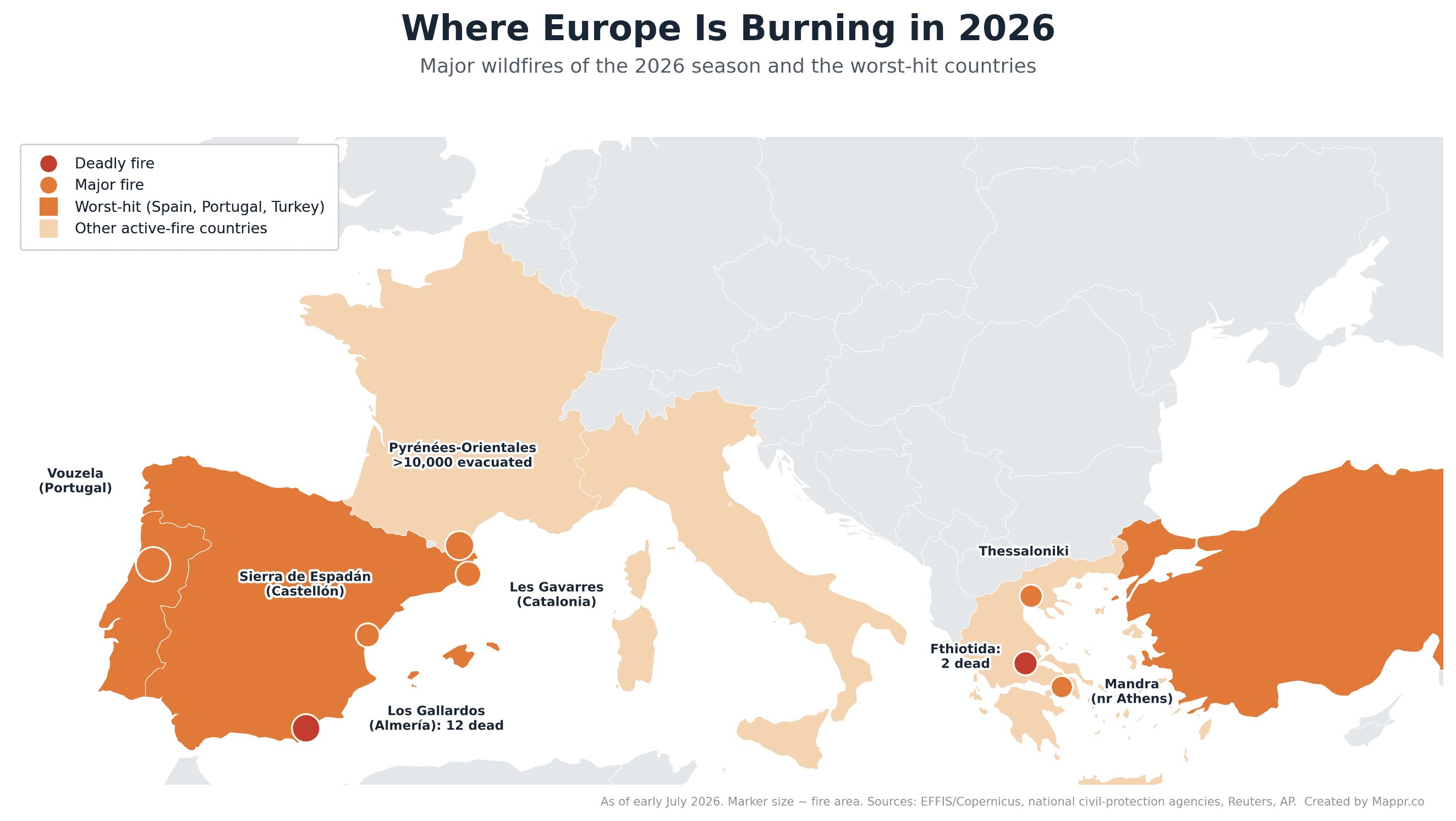
The deadliest fire: Los Gallardos, Spain
The single deadliest blaze of the season so far tore through the area around Los Gallardos and Bédar in Almería, in Spain’s southern Andalusia region. At least 14 people were killed. The first 13 were seven Britons, three Belgians, one French national, one American and one Spaniard; the 14th, a woman injured in the opening hours, died in hospital on 27 July, and her age and nationality were not released.
A 93-year-old British woman who had been badly burned died in hospital on 12 July, and around ten missing-person reports remained open as of 15 July, according to regional authorities. It is the deadliest wildfire in Spain in roughly two decades.
Many of the victims were caught while trying to flee, some in their cars and others on foot along a dry river bed that became a trap as the flames raced downhill. Investigators are examining a downed power line as a possible cause, though the local utility has disputed that account. More than 1,400 people were evacuated from the surrounding villages.
A season stoked by record heat
The fires are inseparable from the heat. According to the Copernicus Climate Change Service, June 2026 was the hottest June on record for Western Europe, averaging 20.7°C, some 3.05°C above the 1991 to 2020 norm. Temperature anomalies peaked at around +9°C over France and Germany, and the mercury hit 45.1°C at Andújar in southern Spain. France recorded its hottest day since national records began in 1947.
Three separate heatwaves swept the continent between late May and early July, drying out vegetation and priming it to burn. Scientists at World Weather Attribution called it the most severe heatwave ever recorded over the region and linked its intensity directly to human-caused climate change.
The heat itself has been far deadlier than the flames: official mortality data from the EuroMOMO network show more than 10,000 excess deaths across 27 European countries in the peak heatwave week of 22 to 28 June, and an AFP analysis puts the full June toll at at least 12,000, a count separate from the wildfire deaths.
The heat has since moved east. Austria set a national record of 41.2°C at Bad Deutsch-Altenburg on 5 August, a day after 41.0°C in Vienna, and Italy put most of its major cities under a red heat alert with temperatures around 40°C.
The grid felt it too. Hungary asked companies and households to cut consumption through a severe drought, and Slovenia’s Krško nuclear plant, which also supplies Croatia, cut its reactor to 80% of capacity because the Sava was running low and warm.
Where Europe is burning
Spain
Spain has been hit hardest. By 20 July its 18 major fires had burned roughly 70,000 hectares, while by late July estimates of Spain’s total burned area for the year had diverged sharply: AP put it at about 130,000 hectares and AFP at more than 168,000 hectares, still the most of any EU country, though France had closed the gap, passing about 115,000 hectares by 26 July.
Beyond Los Gallardos, fires struck Les Gavarres in Catalonia (where a worker using an angle grinder was arrested), the cork-oak forests of the Sierra de Espadán in Castellón, and protected land in Aragón.
The Orés fire in the Cinco Villas district of Zaragoza province, which ignited on 15 July, has stabilised after burning an estimated 14,400 to 15,400 hectares (estimates vary by source) along an 80 km fire line; some 1,000 people from six municipalities were evacuated, and around 450 firefighters and 22 aircraft were deployed at the peak.
Near Madrid, a separate fire on the Guadalajara border burned around 1,500 hectares and forced the evacuation of a summer camp.
By 22 July, Spain’s largest fire of the season, and one of the largest in the country’s recorded history, was the La Mierla blaze in the Sierra Norte natural park of Guadalajara province. Declared on 16 July and provisionally blamed on agricultural machinery, it doubled over one weekend and kept spreading to reach about 32,000 hectares, burning through more than 90% of the natural park.
That surpasses the 2004 Minas de Riotinto fire (around 29,000 hectares), making La Mierla the biggest wildfire ever recorded in Castilla-La Mancha, though still smaller than 2025’s Gestoso (about 45,000 hectares) and Uña de Quintana blazes. Around 1,200 people were evacuated from some 34 municipalities, with more than a dozen others confined.
More than 800 emergency personnel and about 170 air and ground resources, including 100 troops from Spain’s Military Emergency Unit, were deployed, and after six days the fire began to stabilise on 22 July, by 23 July it had entered a stabilisation phase, with the first five of the 34 evacuated municipalities and the nearby Selas area allowed to return home, and on 24 July it was downgraded to emergency level 1 after burning about 35,000 hectares, with residents of six further municipalities cleared to go back.
AEMET’s third heatwave of 2026, which ran to at least Thursday 24 July with highs of 42 to 44 C, fanned it through the worst days. A second fire declared near Selas in eastern Guadalajara reached emergency level 2, burning about 1,700 hectares and forcing six municipalities to evacuate, while a separate, smaller fire had also been declared near Soto de Cerrato in Palencia province on 19 July.
By 23 July new fires had opened across central Spain, including Almorox in Toledo (three villages evacuated southwest of Madrid), Brieva in Segovia (more than 3,000 hectares), Ejulve in Teruel (around 1,400 hectares) and Burgohondo in Ávila, with AEMET rating fire danger very high or extreme across most of the mainland and the Balearic Islands.
On 24 July, as fires around Villa del Prado and San Martín de Valdeiglesias closed to within about 50 km of the capital, the Spanish government declared a national emergency covering the Madrid region and Ávila, reported as its first for wildfires, with more than 10,000 people evacuated across the region and residents of Burgohondo, El Tiemblo and Navaluenga told to stay indoors.
On 24 July two of those fires merged into a single blaze, described by the regional government as the worst in the Madrid region’s history, and it came close to joining a third fire across the border in Castilla y León.
By 25 July Spain’s interior ministry put the burned area at nearly 10,000 hectares in the Madrid region and between 13,000 and 15,000 hectares in Ávila province, with 70,000 people evacuated nationally and more than 2,000 sheltering in 14 emergency centres. Carlos Novillo, the Madrid region’s emergency chief, said the fire was at its peak and beyond the capacity of firefighters to contain, while dozens of homes were destroyed and several roads closed.
The national emergency placed the Military Emergency Unit in charge of coordinating the response, and Italy and Greece each sent two water-bombing aircraft, with further planes from the Netherlands and Portugal.
On 24 July the flames also reached NASA’s Madrid Deep Space Communications Complex at Robledo de Chavela, about 60 km west of the capital, forcing all 90 staff to evacuate; the agency shifted spacecraft communications to its Goldstone complex in California and said damage to the site’s six large antennas would be assessed once it was safe to do so.
By 25 July the interior ministry put Spain’s burned area for the year at about 131,000 hectares, and NASA satellites had detected 5,346 active hotspots across the country in 24 hours.
The largest fronts were reported as Navaluenga in Ávila, at around 22,000 hectares, and San Martín de Valdeiglesias in the Madrid region, at about 14,500 hectares, with 23 towns evacuated across the two regions; prime minister Pedro Sánchez said the priority was to save lives and protect inhabited areas. On the evening of 25 July eight more municipalities were ordered out near Toledo as the fires pushed further west of Madrid.
Spain also recorded the first death of this emergency: a 78-year-old man with reduced mobility was killed by a fire at Manises, northwest of Valencia, caught near his orchard in the Salt de l’Aigua ravine. That fire was later brought under control and the town declared two days of mourning. He was the 14th person confirmed dead in Spanish wildfires this month, with around ten others still missing.
On 26 July the fires in the Madrid region, Ávila and Toledo merged into a single front of about 45,000 hectares, roughly 24,000 of them in Madrid and around 21,000 in Ávila, with a perimeter of more than 200 km. Reports put the number evacuated or confined across the three provinces at between about 88,000 and 100,000.
Twelve municipalities were evacuated in the Madrid region and four confined, alongside 16 evacuated and three confined in Ávila and 11 evacuated in Toledo. More than 3,000 people were sheltering in municipal centres.
Lieutenant General Francisco Javier Marcos of the Military Emergency Unit said crews had stopped an even larger merger at San Martín de Valdeiglesias, while interior minister Fernando Grande-Marlaska called conditions absolutely difficult and said the cabinet was more pessimistic than the day before.
Prime minister Pedro Sánchez said on 27 July that containment was developing very positively, but that there were still difficult hours ahead before the worst areas could be stabilised.
The Navaluenga and Burgohondo fire in Ávila has since become the largest wildfire in Spain’s recorded history. It has burned about 50,000 hectares since 22 July, roughly 32% more than the previous record of 37,765 hectares set in August 2025.
Taken together the central fires now cover around 77,000 hectares along a perimeter of some 280 km: about 50,000 hectares in Ávila, 25,000 in the Madrid sierra and 2,000 in Toledo. Madrid’s own emergency service put the Sierra Oeste fire at about 28,000 hectares on the morning of 28 July.
Official figures on 28 July counted 63,152 people evacuated, 31,865 of them in Madrid, 25,087 in Ávila and 1,941 in Toledo, with a further 35,051 confined to their homes. About 100,000 people are affected, 2,500 of them sleeping in 18 reception centres, and 52 roads are closed.
Thirty-nine municipalities have been ordered out in all: 16 in Ávila, 12 in Madrid and 11 in Toledo. On the morning of 28 July the Madrid fire was still described as out of control, while the Ávila front was evolving favourably and the Toledo fire had stabilised.
Spain’s Council of Ministers met on 28 July and declared the burned areas of Ávila, Madrid and Toledo severely affected by a civil protection emergency. The declaration unlocks grants of up to 15,120 euros for a destroyed home, plus farm and business subsidies, ICO credit lines and tax relief.
A new front opened in the Valencia region on Saturday 25 July, when fire broke out at Vall d’Uixó in Castellón province. By the morning of 27 July it had burned about 6,519 hectares along a 48.7 km perimeter, with 16,000 people evacuated from 16 municipalities and roughly 64,000 confined in Betxí, Vall d’Uixó and Onda.
More than 450 ground personnel, including 65 troops from the Military Emergency Unit, and up to 30 aircraft were assigned to that fire. Around 700 evacuees were still in shelters at Onda, Segorbe, Nules and Moncofa, and eight regional roads were closed.
By 28 July that fire had burned about 8,500 hectares in four days and its perimeter had doubled to 67 km, with some 76,000 people affected. Confinement orders have been lifted and about 6,000 residents allowed home, though roughly 10,000 remain evacuated.
Crews there are also working around unexploded ordnance left in the ground from the Spanish Civil War. Investigators suspect the fire was started deliberately.
Nationally, Spain’s burned area for the year reached 152,678 hectares by 26 July, about six times the 24,133 hectares recorded by the same date in 2025, with 21,565 hectares lost in the single night from Saturday to Sunday. Thirty-two fires have passed 500 hectares this year, against seven at this point last year.
By 27 July that running total had climbed to about 172,000 hectares, still roughly six times the area burned by the same date in 2025.
The cause of Spain’s largest recorded fire emerged on 28 July. The Guardia Civil arrested the operator of an eight-tonne rock-breaking excavator that was cutting a new forest track on the Burgohondo sierra without a permit, in defiance of a ban imposed because of extreme fire risk.
According to El Mundo, the machine belonged to the firm Reforestaciones El Fresno and had been hired by the Burgohondo livestock farmers’ association to open access to high pasture. Its president told the Guardia Civil he had contracted the work but did not know a rock hammer would be used.
The fire started at about 13:00 on Wednesday 22 July when the machine threw a spark into low scrub, and the operator admitted to the first firefighters on the scene that he had caused it.
The Los Gallardos death toll rose to 14 on 27 July, when a woman injured in the first hours of that fire died in the burns unit of the Virgen del Rocío hospital in Seville. Her age and nationality were not released.
By the morning of 29 July the central fires had burned about 80,000 hectares across Madrid, Ávila and Toledo, with a further 10,000 hectares in Castellón. There were no new outbreaks overnight, and crews spent it consolidating the perimeter and cooling hot spots.
Regional president Isabel Díaz Ayuso put the Madrid region’s own burned area at about 34,000 hectares on 28 July, above the roughly 25,000 hectares in the combined national tally, another sign that regional and central counts are still being reconciled.
The stand-down accelerated through Tuesday. Restrictions were lifted for a further 44,000 people in the Madrid region, the central government’s delegate there, Francisco Martín, said after the evening emergency committee, leaving about 10,000 still out of their homes on Wednesday morning.
Evacuations continue at Robledo de Chavela and Valdemaqueda and in several urbanisations at Villa del Prado and San Martín de Valdeiglesias, while in Ávila twelve municipalities remain evacuated and Navaluenga, El Tiemblo and Cebreros are still confined.
The Toledo emergency was cut to level 2 on 28 July and Castilla-La Mancha took over direction of the response. Nine of its eleven evacuated villages went home, leaving Sartajada and La Iglesuela del Tiétar out.
Closed roads fell from 52 to 29 by 08:00 on 29 July: 14 in Ávila, eight in Castellón, five in Madrid and two in Toledo, with main routes such as the M-501 and M-507 reopened.
The Vall d’Uixó fire has gone the other way. By 29 July it had burned about 10,000 hectares along a perimeter of 75.5 km and was still out of control, after flare-ups on Tuesday afternoon at Artana and along the Alcudia de Veo to Tales axis.
Confinement was lifted across the whole town of La Vall d’Uixó, population 32,000, but about 10,000 people from some fifteen municipalities around the Sierra de Espadán natural park remain evacuated. More than 600 ground crew and the air fleet were working the fire on Wednesday.
The Council of Ministers’ declaration on 28 July was broader than the three central provinces. It covered 211 catastrophic episodes between 31 March and 27 July across fourteen autonomous communities, most of them wildfires, including Los Gallardos, and a royal decree-law added emergency labour protections for people whose workplaces were hit.
A new fire was declared on 28 July at La Utrera, in the León municipality of Valdesamario, and remains at level 2, the top of the regional severity scale. About 60 people were evacuated there and six more from the La Velilla neighbourhood while crews consolidated the perimeter overnight.
Spain entered its fourth heatwave of the summer on 28 July, with temperatures forecast above 40 C in places and no rain in the outlook through Sunday. It was still running on 30 July, with highs above 40 C and nights that did not drop below 25 C.
Interior minister Fernando Grande-Marlaska declared the Madrid and Ávila fire technically stabilised on 29 July, on the assessment of the Military Emergency Unit and the regional technical directors. Every evacuation and confinement order in Ávila province was lifted and all its closed roads reopened by 15:00.
On 30 July the last two evacuated municipalities in the Madrid region, Valdemaqueda and Robledo de Chavela, were cleared to return. Only a handful of urbanisations at San Martín de Valdeiglesias and Pelayos de la Presa were still out, and Grande-Marlaska said the fire had not advanced in 24 hours.
The fire is now described as practically without flames, with only scattered smoking points. Taken with Castellón, the fires in Madrid, Ávila, Toledo and Castellón have burned more than 80,000 hectares and affected more than 90,000 people. The Almorox fire in Toledo dropped to operational level 1.
At Vall d’Uixó about 6,000 residents were allowed home by 30 July, with 34 aircraft and some 400 personnel still working the fire. Crews held the Ermita de Santa Bárbara at Onda, but the perimeter was not secured and the risk of further spread stayed high.
A new Spanish front opened in Castilla y León on the afternoon of 29 July, when fire broke out on the southern edge of Fermoselle in Zamora, inside the Arribes del Duero natural park. It was raised to severity level 2 at about 14:15 because of the direct threat to homes.
Fourteen municipalities were evacuated there, among them Tudera, Badilla, Cozcurrita, Argañín and Muga de Sayago, while Fermoselle and Fariza were confined. Around 1,000 people were affected and 54 residents were moved out of a care home in Fermoselle.
By 30 July the Fermoselle fire still had four active sectors, though its northern and eastern fronts had stabilised overnight. León province had seven active fires, nine across Castilla y León, with San Cipriano del Condado, Valdelaloba and Veguellina at level 2.
Thirty roads remained closed on 30 July across Ávila, Castellón, Madrid, Toledo and León, and AEMET kept fire danger at very high or extreme over most of the country.
Later on 30 July the national emergency for Madrid, Ávila and Toledo was cut from level 3 to operational level 2. The Burgohondo fire in Ávila, above 50,000 hectares, had an almost consolidated perimeter and little open flame, and more than 1,000 further residents were allowed home.
The environment ministry put Spain’s burned area for the year at about 180,000 hectares from 38 large fires. Minister Sara Aagesen said the area lost was more than six times the figure at the same point of 2025.
The Vall d’Uixó fire had burned 9,598 hectares along a perimeter of more than 82 km by 30 July, perimetered but not stabilised. On 31 July another 1,800 residents of Alfondeguilla, Chóvar and Sueras went home, leaving about 5,200 evacuated.
Fermoselle grew fast. EFFIS estimates put it above 10,000 hectares on 30 July, and Spanish live coverage above 11,000 hectares along a 75 km perimeter on 31 July, with gusts driving its head into the Duero canyon.
Fourteen villages there remain evacuated and Fermoselle and Fariza confined, though the fire improved overnight and restrictions are to be lifted progressively. Forty forest specialists from Bosnia and Herzegovina were due on 31 July, alongside 99 Military Emergency Unit troops and 35 vehicles.
León had about ten simultaneous fires on 30 July, three of them at the top severity level: San Cipriano del Condado, Veguellina and Valdelaloba. More than 300 people were moved out of six villages and an urbanisation overnight, and the Military Emergency Unit was requested for Veguellina.
Castilla y León approved a reconstruction plan worth 80 to 90 million euros, with 500 euros for each evacuated family and 5,500 euros for affected businesses. Eight roads were closed in Castellón and four in Zamora.
The Vall d’Uixó fire was declared stabilised on 31 July after seven days, having burned 9,568 hectares along an 89 km perimeter. Residents of Artana and Eslida went home and the alert dropped to situation 1, though officials warned of possible flare-ups.
Fermoselle turned the same day. Its perimeter was stabilised after two hard days at about 11,000 hectares along 75 km, and by the evening of 31 July everyone had returned except the residents of Mámoles and Pinilla de Fermoselle, whose terrain keeps ground crews out.
The Zamora fire was cut to level 1 on 1 August. More than 100 foreign personnel had worked it, with 40 Bosnian forest specialists arriving on 31 July a day after Serbian crews, alongside two Turkish water bombers and 99 Military Emergency Unit troops.
León is now Spain’s harder front. The Veguellina fire at Villafranca del Bierzo, blamed on a faulty electrical cable, flared again on its northern flank through the afternoon of 31 July and stayed at level 2, the top of the regional scale.
Of the 405 people evacuated from five villages there, 170 from San Martín de Moreda and Valle de Finolledo were allowed back, leaving 235 out at Moreda, San Pedro de Olleros and Prado de la Somoza. San Cipriano del Condado was stabilised and all 312 of its evacuees returned.
A new fire at San Tirso in Vega de Valcarce closed the left lane of the A-6 in both directions near kilometre 426 before dropping to the lowest severity level at 21:00 on 31 July.
The Madrid and Ávila emergency was wound up on 31 July, ten days after the Burgohondo blaze started.
That stand-down did not hold. The Burgohondo fire flared again on 1 August in the neighbouring municipality of La Adrada, and Castilla y León’s civil protection service sent an ES-Alert ordering the La Picota urbanisation and nearby buildings out.
The fire stayed at severity level 2 ten days after it was declared. It was worked by 126 environmental agents, 64 ground crews, 62 fire engines, nine bulldozers, 16 helitransported brigades and 31 helicopters and water bombers, with 50 personnel from Qatar joining the operation.
Fermoselle in Zamora dropped to level 1 on 1 August. Veguellina in León was declared contained after burning about 1,400 hectares since Wednesday, then cut to level 1 once its perimeter was secured.
Moreda, San Pedro de Olleros and Prado de la Somoza were cleared to return. More than 250 ground personnel and 15 aircraft stayed on the fire, German crews had arrived and a Serbian convoy was due, while the Military Emergency Unit stood down.
León still has more large fires than any other Spanish province. Murias de Ponjos has passed 2,000 hectares, the biggest there this summer, La Utrera is stabilised after 66 evacuations, and a new fire at Portilla de la Reina declared on 1 August is being treated as deliberate.
The environment ministry put Spain’s burned area at 186,480 hectares between 1 January and 1 August, against 33,360 hectares by the same date in 2025. It counts 38 large fires this year, compared with 12 last year.
Burgohondo was still at severity level 2 on 2 August, the most complex fire in Castilla y León and the one carrying the region’s largest deployment: 35 technicians, 129 environmental agents and wardens, 64 ground crews, 62 fire engines and 11 bulldozers.
Sixteen ELIF and BRIF brigades and 42 helicopters and water bombers were also assigned there. Low humidity, rising wind and high temperatures kept the whole regional operation on alert overnight.
León has quietened. Veguellina was down to level 1 on 2 August with its perimeter secured, more than 1,300 hectares burned on the regional count and every evacuee home since Saturday evening.
San Tirso at Vega de Valcarce is now the province’s only active fire, with Murias de Ponjos, La Utrera, San Cipriano del Condado and Valdelaloba stabilised or controlled. Fermoselle in Zamora also held at level 1.
Burgohondo held at severity level 2 on 3 August but was finally called stable, with no jumps outside the perimeter and no live flame after a night that passed without incident. Crews spent the day locating and cooling hot spots as temperatures fell and humidity rose.
Extremadura gained a front of its own. A vehicle that caught fire on the A-66 at Puerto de los Castaños started a blaze at Casas de Millán in Cáceres that ran through about 1,500 hectares along a 20 km perimeter.
By the morning of 3 August it was roughly 70% perimetered and the evacuation orders for Casas de Millán and the hamlet of Grimaldo in Cañaveral had been lifted. Fermoselle stayed contained above 11,000 hectares and Vall d’Uixó stabilised at 9,568.
Satellite estimates now put Spain’s burned area for 2026 above 220,000 hectares, on provisional European monitoring data current to the morning of 3 August. Only 2022 and 2025 were worse at the same point in the past decade.
Burgohondo is now measured in months rather than days. On 4 August the Castilla y León forest service put it at more than 50,000 hectares along a 160 km perimeter, still at severity level 2, and said it would take at least another month before it could be declared out.
Miguel García, a technician with the regional fire service, compared the burned ground to a charcoal kiln whose embers can restart with wind. Deep soil burning is the reason, and officials also worry that storm rain would bring erosion and debris flows.
Fresh outbreaks at La Adrada and at the El Horcajo dam are being investigated as possibly deliberate, and La Adrada was evacuated for a second time in days.
León has quietened further. Four fires were active in the province on 4 August, all at the lowest severity level: Veguellina, Benuza declared on 3 August, Toral de los Vados declared about 11:30 that morning and Horta at Corullón about an hour later.
Murias de Ponjos, past 2,000 hectares and still the province’s largest this summer, is controlled, along with Ocero, La Utrera and San Cipriano del Condado, where four homes were destroyed.
León thinned out again on 5 August. Only two fires were still active in the province, Veguellina in its eighth day and Benuza, both at the lowest severity level, with about a dozen units on Veguellina after it reactivated outside its perimeter on Monday afternoon.
A new fire came closer to the city. It started on the afternoon of 4 August at Oteruelo de la Valdoncina, on the edge of León, forced the N-120 to close and nearby premises to be cleared, and was stabilised by the following morning.
Burgohondo is finally stable. The Castilla y León forest service declared Spain’s largest recorded wildfire stabilised on the morning of 6 August, 15 days after it was declared at 13:00 on 22 July, and cut it from severity level 2 to level 1.
It is not out. Twenty-seven units are still working the 160 km perimeter around the more than 50,000 hectares burned, and the service expects at least another month before the fire can be declared extinguished.
The residents of La Adrada evacuated on Monday for the outbreaks at La Vereda and near the El Horcajo dam have gone home. The Guardia Civil is treating the cause as gross negligence, from sparks thrown by unlicensed heavy machinery opening a forest track for livestock.
Burgohondo passed a quiet night into 8 August. The operation reported no relevant incidents and is working on consolidating and securing the perimeter to lock in the improvement of the past few days.
Two places are still being watched. The west front around Mijares and the area of Cebreros are the concern, and officials say the wind will decide how the day goes.
The scale of the emergency behind it is clearer now. Around 35,000 people were evacuated and more than 10,000 confined, one of the largest civil protection operations Castilla y León has run.
Andalusia now has Spain’s sharpest front. A fire declared on 6 August in the Raboconejo area of Niebla, in Huelva, had passed 4,000 hectares by 8 August, though INFOCA notes that not all the ground inside the perimeter has burned.
It is not under control. Shifting wind kept opening new fronts overnight, gusts of 40 to 50 km/h beat back the first ground attack, and the emergency was raised to operational situation 2.
The evacuations widened on the evening of 8 August. An Es-Alert took 340 more people out of Berrocal, Marigenta, El Membrillo and El Pozuelo, on top of about 70 already moved from Raboconejo, Caballón, La Florida, Las Arenas and El Manzanito.
Two roads are shut, the HU-3106 between Niebla and Valverde del Camino and the A-493. Evacuees were taken to the Teatro Municipal Ruiz Tatay in Zalamea la Real, and five needed hotel rooms.
Crews worked through the night into 9 August. INFOCA counted 309 personnel and 94 resources on the fire, 215 of them its own and 60 from the Military Emergency Unit, after the UME had surged to 250 troops and 100 vehicles on Saturday.
The fire doubled on Sunday. Antonio Sanz, the Andalusian presidency and emergencies councillor, put Niebla at about 8,000 hectares on 9 August, twice the roughly 4,000 of the day before, while noting that many islands inside the perimeter have not burned.
The deployment grew with it. Around 500 professionals worked it through Sunday, 250 from INFOCA and 250 from the Military Emergency Unit plus 16 from the La Iglesuela BRIF, with 178 ground resources and up to 26 aircraft.
The Junta kept 474 people out of their homes, 27 of them sheltered at the Teatro Municipal Ruiz Tatay in Zalamea la Real. Five roads are now closed: the HU-3106, the A-493, the HU-4103, the HU-5104 and the HU-6107.
The strategy is to keep the fire west of the Tinto. Crews built a double defensive line in front of El Pozuelo, Marigenta, Berrocal and El Membrillo, and a second along the left bank of the river to stop the flames reaching Seville province.
It was still out of control early on 10 August. About 605 professionals were committed, crews were burning off ground on the northern flank, and El Madroño and La Delgada in Seville province were put on evacuation pre-warning.
Monday’s forecast was against them. The wind was expected to turn from west to southwest at 30 to 35 km/h with very low humidity through the middle of the day, and heavy smoke was forecast overnight and into the morning.
The fire then ran away from the operation. The Junta put the perimeter at more than 20,000 hectares of eucalyptus, dehesa and pine on 10 August and declared the fire beyond extinction capacity, one of Andalusia’s worst this century.
That phrase is not about a shortage of crews. Officials say convection is throwing secondary fires kilometres ahead of the front, which blunts the value of air support and puts ground teams at risk.
Antonio Sanz, the Andalusian emergencies councillor, was blunt about the outlook: “We are facing an extremely difficult, complex and dangerous wildfire, with the weather conditions continuing to offer us no respite.” There is, he said, no forecast that it will be controlled any time soon.
The fire crossed into Seville province on 10 August. The Junta’s delegation ordered El Madroño and its four hamlets of El Álamo, Juan Antón, Juan Gallego and Villagordo out at 14:13, close to 300 people, sent to the centre at El Castillo de las Guardas.
That took the evacuation total to about 800, up from 474 the day before. The displaced come from Niebla, Villarrasa, Berrocal, Zalamea la Real, Paterna del Campo and La Palma del Condado on the Huelva side, with around 30 sleeping in a theatre and a hotel.
The deployment held above 600. INFOCA counted 15 specialist firefighter groups, 11 engines and 10 heavy machines alongside 250 UME troops and 200 Civil Guard officers, with 26 aircraft assigned for the day.
The night into 11 August brought no new evacuations, but crews could not finish the planned work because of the danger in the northwestern sector. Five roads stay cut and the Minas de Riotinto tourist train is suspended.
Spain picked up a second front in Segovia. A fire at Navas de San Antonio, started on 9 August by a burning vehicle on the AP-6 hard shoulder, reached severity level 2 and pushed about 5,000 people out of Los Ángeles de San Rafael and Vegas de Matute.
Valdeprados was confined and 176 people spent the night in shelters, 137 at the El Espinar sports hall and 39 at the La Panera centre in Villacastín. The N-603 is shut between kilometres 87 and 64 and the SG-722 is closed at Valdeprados.
The evacuees were kept out on 10 August despite calmer conditions, with southerly gusts of up to 38 km/h forecast. A separate fire at Revenga in the same province is running at level 1.
Castellón went the other way. The Tírig fire was stabilised on the afternoon of 10 August after burning 754 hectares across Tírig and Catí, 617 of them forest, and was cut from level 2 to level 1 as the UME began to withdraw.
A fourth front opened in León. A fire was declared at Gradefes on the morning of 10 August, drawing four ground crews, four helicopter brigades, seven aircraft and three bulldozers, with the cause not yet established.
The Niebla fire kept running on 11 August. The Junta put the burn past 25,000 hectares of eucalyptus, dehesa, scrub and pine, and held the emergency in operational situation 2 of the INFOCA plan.
The night’s work paid off on one flank. Crews closed the western front, while the eastern sector at La Pata del Caballo stayed the most active, with the terrain slowing ground operations.
The evacuation figure was revised down to 681, split 500 in Huelva province and 181 in Seville. Fifty-nine were still in shelters: 29 from El Madroño, 25 at the theatre in Zalamea la Real and five at a hotel in Valverde del Camino.
The deployment passed 650 professionals. INFOCA counted 11 engines, 14 bulldozers, 18 forest brigades and 24 technicians alongside 250 UME troops, with up to 26 aircraft assigned for the day.
Eleven roads are cut. Seven are in Huelva, the A-493, HU-3106, HU-4103, HU-5104, HU-6104, HU-6106 and HU-6108, and four in Seville, the SE-538, SE-5400, SE-6400 and SE-6402.
Antonio Sanz kept the warning up. The Andalusian emergencies councillor called the fire still highly complex and dangerous on 11 August, with midday conditions capable of setting off fresh reactivations.
Segovia went the other way. CECOPI let the residents of Los Ángeles de San Rafael and Vegas de Matute go home at 09:40 on 11 August, the SG-722 reopened, and the Navas de San Antonio fire dropped to level 1 at 11:39.
Castellón closed its fire out too. Valencian emergency coordination declared the Tírig blaze controlled at 10:52 on 12 August, after it burned more than 800 hectares inside a 22.8 km perimeter.
León’s fire was short-lived. The Gradefes blaze was left without active flame and stabilised at about 08:50 on 11 August, then dropped to level 0, with up to 61 resources having worked it using controlled burning and heavy machinery.
Spain’s other risk on 12 August is not a fire yet. A total solar eclipse crosses the country, and Protección Civil put the state emergency plan into preemergency at operational situation 1, with a unified command post at the CENEM from 10 August.
The crowds are the problem. About 660 official viewing points have been set up, roughly six million visitors are expected, and more than 35,000 officers are deployed onto a landscape AEMET rates at very high to extreme fire danger.
Some places simply shut. Almatret, La Granja d’Escarp and Seròs in the Segrià agreed to close access to Montmaneu and other wooded areas for the eclipse, and Tres Cantos cancelled its event outright.
The Niebla fire kept running through 12 August. Andalucía Información put it at 28,000 hectares that afternoon after a complex night, though its rate of growth had begun to slow.
By 13 August it had passed 31,000 hectares. The perimeter is now around 120 kilometres, and the daily advance has fallen from 12,000 hectares three days earlier to 6,000 and then about 3,000 on Tuesday.
The evacuation count kept moving. Preventive evacuations since the emergency began total 718 people, 524 from Huelva and 194 from Seville province, after 24 left El Madroñuelo and scattered houses at Escacena del Campo and 13 left Aznalcóllar.
Sixty-two people are still in shelters: 26 at the Teatro Ruiz Tatay in Zalamea la Real, 31 at the Centro de Participación Activa in El Castillo de las Guardas and five at the Hotel Montearoma in Valverde del Camino.
The active fronts have narrowed. The worst are in the northeast near Berrocal and in the east at La Pata del Caballo in Escacena del Campo, where crews are trying to stop the fire crossing the road between El Álamo and Aznalcóllar.
The deployment has grown to 695 professionals and 257 resources, with 120 more UME troops sent from León and eleven roads still cut. General Francisco Javier Marcos Izquierdo said he was optimistic about the fire’s evolution while calling it very complex.
Spain has picked up a serious second front in Aragón. The fire at Peñas de Riglos in Huesca, burning since 10 August, had run through 5,705 hectares on the latest INFOAR perimeter and is held at operational situation 2 level 2 of the PROCINFO plan.
It has emptied nine villages. Some 577 people are out of Villalangua, Salinas de Jaca, Ena, Centenero, Bailo, Larués, Arbués, Alastuey and Botaya, and about 100 more were moved off the Camping Pirineos.
Two more villages are confined. Santa Cilia de Jaca and Binacua were told to stay indoors by an ES-Alert at 20:58 because of smoke, and the A-132, the A-1205 and the road linking the N-240 to Alastuey are shut.
The worry is San Juan de la Peña. The front is about three kilometres from the monastery landscape and Monte Oroel, with bulldozers cutting defensive lines and 18 ground crews, nine engines, four bulldozers, a BRIF unit and two UME sections of 120 troops committed.
Luis Biendicho, the Aragonese environment councillor, called the fire very complex because of the terrain, the forest and the fire’s potential.
The north of the Niebla fire finally gave. Antonio Sanz, the Andalusian vice-president, said on the night of 13 August that the operation had won the battle in the north and northwest sector after a week of fighting it.
The first residents went home with it. Sixty people were cleared to return to Caballón, Raboconejo, La Florida and Las Arenas, all outside the burned perimeter and mostly second homes, the first such decision of the emergency.
The south is another matter. The fire kept spreading through the Seville municipality of Aznalcóllar on 14 August, reaching El Campillo and Madroñalejo and crossing the road towards El Álamo, with the burn past 31,000 hectares and the emergency still at operational situation 2.
The displacement count now stands at 658. They are out of Niebla, Villarrasa, Berrocal, Zalamea la Real, Paterna del Campo, La Palma del Condado, Escacena del Campo, El Madroño and Aznalcóllar, with nine roads closed.
Huesca went the other way. The Peñas de Riglos fire has passed 8,000 hectares, and the government delegation in Aragón evacuated four more villages in the early hours of 14 August: Santa María de la Peña, Triste, La Peña Estación and Yeste.
That takes it to 15 places and more than 900 people. Santa Cruz de la Serós, Binacua and Osia had gone out the day before, Santa Cilia de Jaca and Puente la Reina de Jaca are confined, and the UME and Seprona helped move cultural treasures out of the old monastery of San Juan de la Peña.
The national picture is well ahead of last year. MITECO counted 226,391 hectares burned in Spain to 11 August, 38.2% more than at the same point in 2025, from 43 fires of more than 500 hectares against 24 a year ago.
Niebla has set a record. The fire passed 38,000 hectares on 14 August, a week after it started, making it the most destructive wildfire in Andalusian history and pushing past the 34,000 hectares of Riotinto in 2004.
Juanma Moreno went to Niebla that day. The Andalusian president said the weekend could bring the start of the end of what he called a beast never seen before, while warning that the weather was still changing.
More people went home. Moreno cleared 114 evacuees to return on the evening of 14 August, 20 from Membrillo Alto, 73 from El Pozuelo and 21 from Las Delgadas, all in Zalamea la Real, after 60 the day before.
The deployment is still heavy. More than 875 personnel worked the fire with 33 aircraft at once, 21 engines, 18 bulldozers and 40 forest brigades, with only the eastern flank active and gusts above 50 km/h forecast into the evening.
Aragón is the front that is still growing. The Peñas de Riglos fire passed 12,000 hectares by 15 August, with 1,021 people out of 18 places and nearly 600 personnel and 38 aerial resources committed.
San Juan de la Peña came close. Flames surrounded the meadow around the new monastery on the afternoon of 14 August without reaching the building, and the old monastery was undamaged.
Aragón also picked up six new fires that day. Storms brought little relief because the winds behind them were erratic.
Niebla turned a corner. The fire stopped advancing on 15 August for the first time in eight days, and the Andalusian presidency counsellor, Antonio Sanz, said crews had strangled it and stabilised the fronts.
The count stands at more than 38,000 hectares affected, not all of it burned. A total of 681 people are still out of their homes, 500 in Huelva province and 181 in Seville.
Aragón kept growing. The Peñas de Riglos fire reached a provisional 16,600 hectares at 20:40 on 15 August along a perimeter of about 58 kilometres, with the whole right flank active from tail to head.
The evacuation list grew with it. Bernúes and its 25 residents went out on the afternoon of 15 August, taking the total to 19 places and 1,045 people, and Infoar held the emergency at operational situation 2 level 2.
Zamora opened a new front. A fire declared overnight at La Tejera, in Hermisende, was raised to IGR-2 at 15:45 on 15 August with up to five separate heads, and about 190 people were moved out of Castromil and San Ciprián.
It came back down the same evening. The Junta lowered it to IGR-1 and both villages were cleared to go home, after the ZA-L-2698 had been cut and a shelter set up at Puebla de Sanabria.
Galicia stayed small. The Lousame fire in the Lesende parish of A Coruña was stabilised at 08:43 on 15 August at about 20 hectares, and an 8-hectare fire at Riós in Ourense triggered a precautionary situation 2.
Spain now carries more than half of the EU’s burned area. EFFIS put the country at 265,457 hectares to 12 August, 52.2% of the EU total of 554,788, after a week that added 42,225 hectares, a rise of 19%.
Niebla is stabilised. Andalusian president Juanma Moreno declared the fire stabilised at 10:30 on 16 August, nine days after it started, with more than 38,000 hectares affected across eleven municipalities in Huelva and Seville.
The shelters have almost emptied. Another 114 people were cleared home overnight from Zalamea la Real, El Pozuelo, El Membrillo Alto, Las Delgadas and Marigenta, leaving 52 in temporary accommodation, 22 at Zalamea la Real and 30 at El Castillo de las Guardas.
More than a thousand people were still on it. The operation on 16 August combined UME soldiers, 515 Civil Guard officers and ministry crews across the eleven affected municipalities, working to consolidate the perimeter rather than chase a running front.
Aragón did not follow. The Peñas de Riglos fire held at about 16,600 hectares through 16 August with 1,046 people out of 19 places, and more than 1,000 personnel, 21 engines, 18 machines and 33 aircraft worked it around the clock.
The wind kept it alive. The fire director, Francho Aso, said the evolution could be read with some optimism after crews slowed the push towards Monte Oroel, but the fire was still officially uncontrolled with flames along much of the perimeter.
Riglos was revised upward. The Aragón government put the fire at about 17,500 hectares on the evening of 17 August, along a perimeter of roughly 100 kilometres, with a good part of it stabilised after two calmer nights.
The evacuation has not moved. All 1,046 people from 19 places were still out on 17 August, with about 1,000 ground personnel and 42 aircraft on the fire and convoys run in so residents could collect belongings and tend animals.
The first returns are being weighed. Santa Cilia de Jaca and Puente la Reina de Jaca have been deconfined, and Bailo and Larúes were named the best candidates for a return on 18 August, with drinking water the main obstacle.
The weather is the risk again. Forecasters gave 18 August 36°C, humidity of 14 to 15% and westerly gusts near 38 km/h, and Aragón’s interior director, Miguel Ángel Clavero, called the fire very large and still very hot.
France sent crews. The EU Civil Protection Mechanism moved 104 French ground firefighters and 36 vehicles into Aragón after Spain activated it, alongside the aircraft already committed.
Niebla has come down a level. Andalusia dropped the emergency from operational level 2 to level 1 after stabilisation, with a perimeter of about 210 kilometres and the military emergency unit starting to withdraw.
Riglos has killed a soldier. A UME water tanker carrying four military firefighters rolled into a ravine near Atarés on 16 August, killing one of them and injuring three, one of whom was taken to the Miguel Servet hospital in Zaragoza.
The fire was at about 16,600 hectares that day. Aragón’s president, Jorge Azcón, called it the worst news, and prime minister Pedro Sánchez sent condolences to the family and to the unit.
The fire has since been remeasured. The Aragón government put it at about 18,400 hectares on the evening of 18 August, saying the rise from 17,500 was a more precise measurement rather than any advance of the fire.
The returns began on 19 August. Seven of the 19 evacuated places, Santa María de la Peña, Salinas de Jaca, Villalangua, Larúes, Bailo, Arbúes and Alastuey, were cleared to go home progressively with Civil Guard support.
Twelve places are still out. Localities nearer the active ground, among them Serena and Centenero, were given another 24 to 48 hours, and the Civil Guard opened an information point at Bailo for residents reporting damage or theft.
Niebla has gone a step further down. Andalusia cut the emergency to operational level 0 on 17 August, the last 417 displaced residents were cleared home, and by 18 August the operation was halved to 45 personnel and four engines.
The Riglos returns widened on 19 August. Aragón had 583 people from 13 of the 19 evacuated places back in their homes by that evening, with Ena, Centenero, Botaya, Atarés, Santa Cruz de la Serós and Binacua still out.
The operation is standing down with them. About 100 French firefighters and a Super Puma helicopter left along with crews sent by other Spanish regions, and Aragón expected to declare the fire stabilised early on 20 August before withdrawing its last UME section.
The fire itself has stopped moving. It held at about 18,400 hectares along a perimeter of roughly 100 kilometres, with nine ground brigades, eight water tankers and 18 nature protection agents working residual hot spots inside the perimeter overnight.
The one incident was near Santa Cruz de la Serós. A flare-up southwest of the village was held by the crews already there without touching the control lines, and forecasters gave 20 August temperatures 10 degrees lower with rain returning.
Riglos is stabilised. Aragón declared it on 20 August, ten days after the fire started, after a storm dropped almost 15 litres per square metre overnight on the most active ground.
The area came down with the measurement. The perimeter stands at 18,400 hectares, but satellite mapping put the ground actually burned inside it at 14,500 hectares.
The returns widened again. Another 117 people from Centenero, Ena and Botaya were cleared to go home on 20 August, leaving 203 still out from Atarés, Santa Cruz de la Serós and Binacua.
Spain’s new front is in Extremadura. A fire that started at the Avellanar hamlet in Pinofranqueado, in the Cáceres comarca of Las Hurdes, was raised to level 2 of the Infoex plan on 18 August with about 700 people out of eleven alquerías.
It ran at Salamanca. A flank crossed into the province on 19 August, and the Junta de Castilla y León said the crossing was controlled with no active flame on its side, keeping more than 130 personnel on the border against another jump.
The fire peaked near 4,800 hectares. Extremadura put it at that on the morning of 20 August along a 48 kilometre perimeter, with 273 ground personnel and 24 aircraft committed and Nuñomoral confined under heavy smoke.
A remeasurement brought it back. The perimeter was reassessed at 4,250 hectares on 21 August, and the emergency coordinator, Abel Bautista, said the fire had evolved favourably after a night worked by 163 personnel.
Then it came back again. Infoex put the burn at 3,765.34 hectares on 23 August after satellite imagery replaced the helicopter estimate, and warned that even this figure can still move.
The returns started with it. Aceitunilla, Erías and Cerezal were cleared to go home on 21 August, Cerezal under confinement inside the village, and confinement was lifted at Avellanar, Castillo and Nuñomoral with power restored across the perimeter.
The national balance has flipped. MITECO counted 254,730 hectares burned in Spain to 17 August from 6,685 incidents, the first reading of the campaign below the same point in 2025, when 295,580 hectares had gone, a fall of 13.8%.
Forty-two of those were large fires. Blazes of more than 500 hectares account for 223,872 hectares of the total, while 4,382 of the 6,685 incidents never got past a single hectare.
Riglos is controlled. Aragón declared the Peñas de Riglos fire controlled on the afternoon of 21 August, eleven days after it started, with the burned area put at about 14,500 hectares.
The last evacuees are home. The 74 residents of Santa Cruz de la Serós were the last of 1,046 people evacuated from 19 localities, two campsites and a temporary camp, and Aragón dropped the emergency to operational situation 0, level 0.
Controlled is not out. Crews stayed inside the perimeter to find and smother reproductions, helped by a small storm late on 20 August that left between 2 and 5 litres per square metre on the fire ground.
Las Hurdes is stabilised. Extremadura declared the Pinofranqueado fire stabilised at 19:45 on 21 August, four days in, and lowered it from level 2 to level 1 of the Infoex plan after a Cecopi meeting at the advanced command post.
The last restrictions went with it. Cerezal, El Gasco and Martilandrán came out of preventive confinement, the roughly 700 people evacuated from ten alquerías and 38 residents of the Cottolengo de Las Hurdes were back, and the unified command with Infocal and the UME was stood down.
Spain opened a new front as it closed the old ones. A dry-storm lightning strike at 20:20 on 20 August lit the Sierra Calderona natural park above Segorbe, in Castellón, and the fire crossed into Gátova in the province of Valencia.
Gátova emptied on the Friday. About 1,000 residents were moved out on the afternoon of 21 August, the emergency went to situación 2 and the CV-25 was closed with checkpoints at Olocau and Altura.
It was stabilised on 23 August. The declaration came at 07:25 that morning at a provisional 633 hectares along an 18 kilometre perimeter, roughly 395 of them in Segorbe and 235 in Gátova, and the alert dropped to situación 1.
The village went home the same day. Around 130 personnel and ten aircraft were left on the fire, the UME was demobilised, and returning residents were given bottled water while the supply was tested.
Las Hurdes is controlled. Extremadura declared the Pinofranqueado fire controlled at 20:00 on 23 August, six days after it started, and cut the danger level from 1 to 0.
The comarca has started protesting. About 200 people gathered in Pinofranqueado’s Reina Victoria square on 22 August under the banner “Hasta aquí. Ni un verano más”, and the Movimiento Ciudadano por Las Hurdes called a second protest for 19:00 on 23 August at Nuñomoral.
Gátova came out of confinement. Valencia lifted the village’s confinement on 24 August and reopened the CV-25, though the forest tracks and paths around the burn stay closed.
Stabilised is not controlled. There was still no formal control declaration on the evening of 24 August, with the fire holding at a provisional 633 hectares along an 18 kilometre perimeter while ground crews worked hot spots, smoke columns and residual combustion inside it.
The tap water verdict was due on 25 August. Returning residents were told to keep to bottled water until the analysis of the Gátova supply came back.
Segorbe is controlled. Valencia declared the fire controlled at about 19:00 on 25 August, six days after the lightning strike, once crews had isolated the flames and stopped them advancing.
The final figure is about 630 hectares. All of it burned inside the Sierra Calderona natural park, 395 hectares in the Segorbe municipality and 235 in Gátova.
What was left on it was modest. Three forestry units with two engines, two brigades from the Valencia provincial consortium, two rural brigades and a forestry unit from Castellón worked the last of the fire.
Spain’s satellite total has been revised down. EFFIS had 294,894 hectares mapped in Spain to 26 August from 427 fires of 30 hectares or more, about 2,900 hectares below the previous reading and still well short of the 393,079 hectares of 2025.
France
In France, a fast-moving blaze in the Pyrénées-Orientales near the Spanish border forced more than 10,000 people from around two dozen towns and villages. By mid-July the fires had spread north: a blaze of exceptional scale in the Fontainebleau forest south of Paris forced evacuations on 13 July, with aircraft scooping water from the River Seine to fight it, and a separate fire in the Pyrenees drove around 12,000 more people from their homes.
By 22 July France had lost more than 42,000 hectares for the year, a record at that point, and two firefighters were killed on 21 July tackling a fire that spread from brushland to a building near Bordeaux-Mérignac airport, forcing flight delays, while a large fire in the south of the country was brought under control the same week.
On 23 July a fresh fire near the Arcachon basin southwest of Bordeaux forced more than 10,000 people from their homes overnight, and by 24 July it had burned at least 2,400 hectares west of Bordeaux, prompting France to activate the EU Civil Protection Mechanism; EU crisis commissioner Hadja Lahbib said the bloc was sending three water-bombing aircraft.
Over the following 48 hours that fire grew to what Gironde prefect Sophie Brocas called an unprecedented magnitude, burning to within about 30 km of Bordeaux and forcing evacuations in the western suburbs of Le Haillan, Eysines and Mérignac.
On 25 July interior minister Laurent Nuñez said 57,000 people had been evacuated overnight in the Gironde, taking the region’s total to 167,000 and the combined Gironde and Landes figure to 197,000, probably the largest peacetime evacuation in French history, and that about 98,000 hectares had burned across France in 2026, a historical record, with blazes still uncontained in the Gironde, the Landes and the Var.
Prime minister Sébastien Lecornu said the fires had reached a level never seen before and that the Gironde blaze was generating its own winds. More than 1,000 soldiers, an A400M military transport dropping retardant and around 100 Paris firefighters were sent to the southwest, joined under the EU mechanism by two water-bombers from Croatia, two from Portugal and two Black Hawk helicopters from the Czech Republic and Slovakia.
By 25 July some 54 firefighters had been injured in the Gironde, nine of them evacuated with non-life-threatening injuries, though no deaths have been reported in the Gironde and Landes fires; the blaze had destroyed about 140 houses, with more than 50 lost on the Cap Ferret peninsula, from which 44,000 people were evacuated.
Overnight into Sunday 26 July gusting winds drove the fire on again: a further 55,000 people were ordered out, taking the Gironde total past 220,000 and the number displaced across France beyond 250,000, about 30,000 of them in the Landes.
The fire had by then burned roughly 42,000 hectares, one of the largest France has faced since the Second World War, and had closed to within about 15 km of Bordeaux, whose mayor said it was still at the gates of the metropolitan area.
Authorities shut 60 km of the A63 motorway between Bordeaux and the Spanish border, SNCF halted trains south of the city, and 1,500 soldiers and 1,700 security personnel were deployed alongside an A400M transport dropping 20 tonnes of water and retardant per run. Thirty-four firefighters from French-speaking Switzerland arrived with 11 vehicles, and Bern was weighing a French request for four light helicopters made through the EU mechanism.
Nuñez said the fire would take a long time to bring under control, while Marc Vermeulen of the Gironde fire service said night conditions were conducive to firefighting operations. Tour de France organisers cut the race’s final stage from 133 km to 89 km and moved its start to the Champs-Élysées so that police assigned to the event could be redeployed to the fire zones, and a fourth heatwave is forecast to reach the country from Tuesday.
Overnight into Monday 27 July the Gironde prefecture described the situation as globally stable, with a clear fall in the number of active fires and no new evacuation orders, the first respite after days in which the blaze had pushed towards Bordeaux.
By that morning the fire stood at about 42,000 hectares in the Gironde, with a further 3,600 hectares burned in the Landes. Sixty-eight firefighters had been injured, 10 of them evacuated, and around 140 houses destroyed, with no civilian deaths reported in either department.
The response had grown to 2,500 firefighters, 1,500 soldiers, nearly 1,200 police and gendarmes and 450 civil protection volunteers, backed by 18 aircraft: two Canadairs, two Dash water bombers, three helicopters and 11 Air Tractors. Partial closures remained on the A63 between Liposthey and Cestas and between the Bordeaux ring road and Marcheprime.
Nuñez said on 26 July that about 115,000 hectares had burned across France since the start of the year, far more than anything seen in the past, and that the country was dealing with 30 to 40 fires a day. President Emmanuel Macron chaired a crisis meeting on the morning of 27 July.
Gironde authorities banned holiday camps for children and for people with disabilities, and forecasters expect temperatures to climb again from Tuesday, which would make the fight harder.
Macron flew to the Gironde on 27 July and told emergency crews this was the most difficult situation France has faced since the Second World War, warning that the usual August peak of the season is still ahead. He said the pine forest that grows back would be a different one.
By that evening the picture had split in two. The Biscarrosse fire in the Landes was declared under control, while the far larger Gironde blaze was described as stabilised but not yet contained, having stopped growing after overnight drizzle.
Fire chiefs warned it will keep burning for weeks, and probably several months, before it is fully out. The blaze is thought to have been started accidentally by a brush-clearing machine.
Damage figures were revised upward: about 240 homes destroyed in the Gironde, 152 of them at Le Porge, with a further 198 buildings lost near Biscarrosse in the Landes. Eighty-four firefighters have been injured nationally, and no civilian deaths have been reported in either department.
France’s interior ministry now counts 13,566 fires and more than 116,000 hectares burned since January, against about 70,000 hectares in the whole of 2025. It is the highest annual figure in the country’s modern records.
A fourth heatwave reached the country on Tuesday 28 July, with 40 to 42 C forecast in the southwest, above 35 C in Paris and the northeast, and nights staying over 25 C. Under the EU mechanism France has received seven aircraft and four helicopters.
On 28 July the Gironde prefecture ordered about 4,000 more people out of campsites, holiday villages, tourist residences and leisure parks around Lacanau, including Lacanau Océan and both shores of the lake, as a precaution against a flare-up on the fire’s north-western flank.
At the same time roughly 60,000 people evacuated from Le Haillan and parts of Mérignac and Eysines, outside Bordeaux’s ring road, were allowed back, though they were told to keep their phones on and emergency bags packed.
Fresh flames broke out that afternoon near Grand Crohot, a beach on the Lège-Cap-Ferret peninsula, and the air fleet was raised from 18 to 23 planes and helicopters. Fourteen flare-ups were recorded across the day, all of them dealt with.
Gironde prefect Sophie Brocas put it bluntly: “The situation remains complicated. That’s clear. We’re not out of the woods.” By that evening crews had cut 121 km of the 127 km of tactical firebreaks planned.
The prefecture’s 06:00 bulletin on 29 July reported a second calm night, with the fire still stabilised and several flare-ups treated quickly at the Camp de Souge, Arès and Le Temple. The burned area had not moved from 42,000 hectares.
The injury count has climbed to 126 firefighters since the fire began, and 15 people have been arrested over the course of the emergency. Traffic restrictions were unchanged on Wednesday morning.
Wednesday is the real test. Météo-France placed the department under an orange heatwave warning from midday, with up to 41 C inland and 38 C on the coast, dry south-easterly winds in the morning, westerly gusts of 30 to 45 km/h in the early afternoon and falling humidity, followed by a risk of thunderstorms on Thursday.
At 42,000 hectares the Gironde blaze is the largest French forest fire since a deadly fire in the Landes de Gascogne in 1949, which burned roughly 50,000 hectares.
At its most violent it built a pyrocumulonimbus cloud, a fire-generated thunderstorm that threw out lightning, violent winds and new outbreaks beyond the main front. It was the first ever recorded in France.
In the Landes the picture is better. The fire there is now described as fixed rather than merely stabilised, and about 15,000 evacuees, roughly half of those displaced, were allowed home on the night of Monday 27 July, among them residents of Sanguinet, Parentis-en-Born and Biscarrosse’s aviation village and a large campsite.
Between 300 and 350 firefighters are still working there, and officials stress the fire is not out: hot spots, wind and drought could restart it, and damping down is expected to run for days or weeks.
Separately, in the southeast a fire fanned by the mistral around the historic village of Cotignac in the Var has burned about 2,550 hectares and destroyed some 25 houses since it broke out on Tuesday, with nearly 1,000 firefighters deployed before it was contained within its perimeter.
That fire, on the Gros Bessillon massif, was declared officially fixed at 19:30 on 28 July, with crews still treating edges and reactivations around Correns and Barjols. A separate blaze in the Écrins massif in the French Alps has also been contained.
The Gironde prefecture’s 23:00 bulletin on 29 July revised the human cost sharply upward: 230 firefighters injured since the fire began, against 126 counted that morning, and 240 homes destroyed. The response stood at 3,300 firefighters, 1,500 soldiers, 1,400 security personnel and 24 aircraft.
Seven new starts were recorded through the heat of 29 July, at Sainte-Hélène, Saint-Jean-d’Illac and Lanton among others, three of them still active that evening. Crews were treating 240 km of perimeter edge. Prefect Sophie Brocas said that if the night passed well, a return to more normal life could be envisaged.
It did. The 06:00 bulletin on 30 July reported a third calm night, the fire still stabilised and the burned area unchanged at 42,000 hectares, with six fires active. Attention centred on the dune belt from Grand Crohot to Le Porge and on the southern shore of the Lacanau lake.
The weather turned for the first time in a week. The orange heat warning was lifted at 06:00, highs fell to between 27 and 34 C after 41 C on Wednesday, showers crossed the coast between 05:00 and 09:00 and humidity sat near 80%. The Gironde fire service said crews were reasonably optimistic.
That allowed the biggest stand-down yet. Some 84,000 residents of nine communes went home on 30 July: Mios, Le Barp, Cestas, Saint-Jean-d’Illac, Martignas-sur-Jalles, Saint-Médard-en-Jalles, Saint-Aubin-de-Médoc, Salaunes and Sainte-Hélène.
The A63 reopened in both directions at 14:00 after a week of closure between Bordeaux and Bayonne, though the D106 stayed shut and TGVs still did not run south of Bordeaux except towards Toulouse and Tarbes. Some 19,500 businesses remained closed and 61,500 people were unable to work.
A new French front opened well inland. A fire declared at 15:15 on 29 July in the Combe Vaulon at Couchey, south of Dijon in the Côte-d’Or, ran through about 125 hectares in south-westerly winds of 35 km/h and was not yet fixed on 30 July.
Some 151 firefighters and 78 vehicles were committed there, with reinforcements from the Yonne, the Nièvre and Meurthe-et-Moselle, and two water-bombing helicopters made about 50 drops. Protective lines were set up in front of the first houses at Marsannay-la-Côte. No casualties were reported.
The Couchey fire was declared fixed at 18:02 on 30 July after more than 24 hours of work. It burned about 90 hectares of the 150 it ran through, no homes were hit and two firefighters were slightly injured.
More than 200 firefighters were mobilised there at the peak, backed by a Puma water-bombing helicopter and two Condors. The gendarmerie has appealed for witnesses and has not ruled out arson.
Back in the Gironde, the prefecture’s 20:00 bulletin on 30 July called it a first day of optimism. Two active points remained at 19:00, one south of the Lacanau lake and one near Claouey on the Cap Ferret peninsula.
The stand-down went further through the day. A cumulative 144,000 residents of twelve communes had been cleared to return by that evening, against the 84,000 counted at lunchtime.
Interior minister Laurent Nunez said the worst was probably behind them, while insisting vigilance was still needed because of the two remaining hot spots.
The bulletin revised injured firefighters to 231 and kept homes destroyed at 240. The response stood at 3,300 firefighters, 1,500 soldiers, about 1,250 internal security personnel and 24 aircraft, working 240 km of perimeter edge.
The A63 was open again, though about 160 km of railway south of Bordeaux stayed shut while SNCF ran diagnostics on the line.
On EFFIS satellite mapping France has now lost about 91,000 hectares, already more than any full year in its record, and August is normally the worst month.
The prefecture’s 20:30 bulletin on 31 July held the burned area at 42,000 hectares and said the fire was still not fixed. Of a 240 km perimeter, 88 km needed securing, 49 km of it already done and 39 km in progress, and 150 of the 172 km of tactical firebreaks had been cut.
The returns accelerated again. Some 198,000 of the more than 220,000 people evacuated since 22 July had been cleared to go home, and 264 firefighters had been treated by the health services. Rail south of Bordeaux was due to reopen on Saturday 1 August.
On 1 August, after nine days, the Gironde fire was declared contained. The fire service described a fairly mild night and slightly more favourable conditions, while stressing the blaze is contained rather than fixed.
France’s trouble then jumped southeast. The Gros Bessillon fire in the Var, declared fixed three days earlier, restarted at about 13:30 on 31 July when gusting mistral and storm winds relit embers on its southern edge.
It ran through about 1,250 hectares in a few hours, on top of the roughly 4,500 it had burned the week before, and prefect Simon Babre ordered 2,500 people out of Correns, Montfort-sur-Argens, Carcès, Le Val and Châteauvert through the FR-Alert system.
Babre said the fire was moving faster than a horse at a gallop and defied comprehension. By 1 August the response had reached 1,300 firefighters backed by eight Canadairs, two Dash water bombers and six helicopters, with four relief columns arriving from other departments.
That morning he said the locks on the sensitive points had held and no new ground had burned. The RD45 was shut between Châteauvert and Correns, every forest in the Var was closed to the public, and the prefecture banned retail fuel sales and carrying lighters until 3 August.
Back in the Gironde, the prefecture’s 20:00 bulletin on 1 August declared the fire fixed, with two active hot spots left on the Cap Ferret peninsula and the dune cord south of Lacanau. Fixed does not mean out, and air and ground crews stayed on the sector.
Of the 23 communes evacuated since 22 July, 21 had been reintegrated by that evening and 208,000 people were cleared to return. Only Lège-Cap-Ferret and Le Porge were still out.
The bulletin revised the human cost again: more than 330 firefighters injured, and 252 buildings of over 20 square metres destroyed out of 2,725 standing in the fire zone. No civilian was killed or hurt.
The response still numbered 3,300 firefighters, 1,500 soldiers, 1,470 gendarmes, more than 700 police and 24 aircraft including an A400M. More than 1,000 partial-activity claims had been filed, covering over 10,000 employees.
Rail ran one TGV in two south of Bordeaux on 1 August, with normal service due back on Sunday morning. Residents of Arès were allowed home from 14:00.
In the Var, mapping on 1 August put the Gros Bessillon fire at close to 6,000 hectares in all, about 1,500 of them burned in three separate runs since the 31 July restart.
The response grew to 1,500 firefighters and 310 vehicles with 15 relief columns, and about 2,800 people had been moved out as a precaution. Rain fell on the fire late on 1 August, though the mistral was forecast to return the next day.
The prefecture’s 08:30 bulletin on 2 August said the perimeter had held overnight with no new ground burned. Confinement was lifted in the centre of Correns and evacuation in the northern quarters of Le Val, and the D45 reopened until 13:00.
In the Gironde the reintegration was finished on 2 August. The prefecture cleared the village of Le Porge, the town of Lège and the Cap Ferret peninsula to return from 14:00 and 19:00, the last of the 23 communes evacuated since 22 July.
Restrictions have not gone entirely. Campsites and light dwellings in both communes stay closed, as do the Le Ferron and Plein Soleil sectors while unexploded ordnance is cleared, and the forest is off limits because weakened pines may collapse.
Back in the Var, the fire has now run through about 1,850 hectares since the 31 July restart. Two flare-ups on 2 August were held, aircraft made 225 drops with six Canadairs, five water-bombing helicopters and three Dash, and the prefecture called the situation improved but fragile.
Seventy homes there have been hit and 41 destroyed. Correns residents went home that evening and the village confinement was lifted.
The 09:00 bulletin on 3 August reported no restart overnight, with crews cooling the points that had flared the day before. Some 1,500 firefighters and 120 gendarmes are working 270 km of perimeter edge, and the RD45, RD22 and RD554 remain closed.
Military engineering units opened new access tracks overnight with bulldozers so equipment could be pre-positioned. Temperatures fell and humidity rose, but an east-southeasterly wind was forecast for the afternoon.
The fire was still not fixed at nightfall. The prefecture’s 20:00 bulletin on 3 August, its fourteenth day, described numerous hot spots and a reactivation near Correns that morning, held with more than 100 aerial drops.
The response stood at 1,500 firefighters, four water-bombing helicopters including two heavy machines, and 120 gendarmes flying reconnaissance drones. Southeasterly gusts reached 50 km/h and the fire gained no ground.
For the first time in 14 days the prefecture ordered no evacuation and no confinement. The RD45, RD22 and RD554 remained closed.
The operation was scaled back on 5 August. The prefecture’s 09:30 bulletin, the fifty-first of the fire, listed 800 firefighters and 250 vehicles, against the 1,500 firefighters committed two days earlier.
One flare-up near Correns overnight was put out quickly by ground crews, and SDIS83 drone teams worked through the night to find hot spots for the day shift. Shifting winds, extreme heat and drought still make the edges fragile.
The fire has not been declared fixed. The RD22 between Montfort and Le Val and the RD554 between Châteauvert and Le Val stay closed, and the Var has banned the transport of fuel cans and lighter fluid until 08:00 on 8 August.
Four forest massifs are closed to all access on the severe fire risk, and four communes have cancelled their fireworks displays.
The evening bulletin did not change that. The prefecture’s 20:15 point on 5 August, the fifty-second of the fire, still stopped short of declaring it fixed, with crews treating edges and hot spots through extreme heat and helicopters supporting them.
The department braced for worse. Wind to 50 km/h and temperatures near 40°C were forecast for 6 August, eight of the Var’s nine massifs were closed and four rated at extreme risk, the Maures, the Sainte-Baume, the Centre-Var and the Haut-Var.
A second fire showed how thin the margin is. A lorry tyre blowout on the RD43 at Camps-la-Source started a blaze that burned 5 hectares and took 150 firefighters, water-bombing helicopters and a Dash. The RD22 and the RD45 remain closed.
The forecast held. The prefecture’s 20:00 bulletin on 6 August called it a high-risk day and again stopped short of declaring the Gros Bessillon fire fixed, after reactivations at Vallon Sourn and at Brignoles were caught and held.
The deployment went back up. Some 850 firefighters were committed, with two Canadairs at Hyères, a Dash and water-bombing helicopters on call, and crews held positions close to the vulnerable sectors overnight.
Three roads are now shut: the RD22 between Montfort and Le Val, the RD45 between Châteauvert and the Vallon Sourn, and the RD562 between Le Val and Carcès, with diversions on the RD224, RD24 and RD13. Gendarmes made about 500 checks on the prefect’s ban on carrying fuel and lighters.
The Var fire is finally fixed. The prefect, Simon Babre, and the SDIS 83 director, Éric Grohin, announced it from the command post at Carcès at 19:30 on 7 August, 18 days after the fire started at Pontevès on 21 July, the longest in the history of the Var fire service.
The final count is 6,300 hectares run through and 5,700 burned, across Pontevès, Correns, Cotignac, Carcès, Montfort-sur-Argens, Châteauvert and Barjols. Seventy homes were hit and 41 destroyed, and about 6,000 people were evacuated at one point or another.
Fixed is not out. The prefecture says it will take several more days to bring the fire under control and then extinguish it, and 450 firefighters stay on site through the weekend treating the burned ground.
The mobilisation was the largest the department has seen: 4,250 Var firefighters, 6,870 reinforcements from the rest of France, 100 European firefighters, 200 gendarmes and 335 military engineers over the 18 days, with 3,800 aerial drops.
Three restarts, on 21, 24 and 31 July, are what made it so long. The prefecture says they are puzzling specialists and investigators alike.
France’s trouble has moved again. A fire in the Claps massif in the Drôme, burning since 3 August, had covered close to 300 hectares by the evening of 7 August, with the head still complex at Beaumont-en-Diois and a fresh run on the eastern flank in the Rochas sector.
Two more fronts opened on 7 August. About 120 firefighters with two Canadairs and a Dash worked a fire that started around 13:00 by the Lac de Naussac at Naussac-Fontanes in the Lozère and took about 100 hectares, while a fire near Narbonne in the Aude was fixed overnight at about 100 hectares.
The risk map stayed lit. Météo-France kept the Drôme and the Lozère at high fire danger for 8 August, along with much of the Mediterranean arc, and the Var prefect closed the Sainte-Baume, Haut-Var and Maures massifs for extreme risk, with the Monts Toulonnais, the Corniche des Maures and the Centre-Var also shut.
The day went better than the forecast. The Drôme prefecture declared the Claps massif fire stabilised on 8 August after it ran through more than 300 hectares, with two contained flare-ups on the southeast and northeast flanks still watched in case the wind turned.
The Lozère fire is out. The blaze that started by the Lac de Naussac on 7 August was fixed with 65 hectares burned, below the roughly 100 first reported, and the Var’s Gros Bessillon stays fixed with 450 firefighters still treating the burned ground.
The Drôme fire was not done. The Claps massif blaze took about another 50 hectares on 9 August to reach 370, after the prefecture reported two significant reactivations that morning.
Four firefighters were lightly injured that day. The deployment stood at 408 firefighters with three Dash aircraft and a water-bombing helicopter.
France then got a second fire in the Lozère. It started about 12:45 on 9 August on a track at Massegros-Causses-Gorges, roughly 140 km northwest of Montpellier, and is thought to have begun with a burning vehicle.
It moved fast, running through 153 hectares of moorland in a few hours. The hamlets of Pertuzades and Le Duc were evacuated around 17:00, more than 270 firefighters were committed and two houses were saved.
The prefecture declared it fixed. The 15 or so evacuated residents were back in their homes by about 22:00 that evening.
The Lozère figures firmed up on 10 August. AFP put the burn at 150 hectares rather than the 153 first reported, and the prefecture timed the fix at 08:00 after crews spent the night soaking the ground.
More than 270 firefighters worked it with four Canadairs and two Dash aircraft. The hamlets evacuated at La Tieule, about twenty homes, were back the previous evening.
The Drôme fire slowed to a crawl. The prefecture reported slow progression on 10 August, roughly 30 hectares more than the day before, for a total of about 400 hectares in the Claps massif.
The smoke reached the villages instead. Around 40 residents at Charens and nearby were told to stay indoors, and Météo-France put 17 departments on elevated forest fire danger for the day.
The Drôme fire is into its second week. The blaze in the Claps massif above Bellegarde-en-Diois was still progressing on 11 August at about 400 hectares, more than a week after it started.
More than 570 firefighters and soldiers are committed. They are working out of a base camp set up at a former holiday centre, with tents, dry toilets, showers and a kitchen.
The villages have taken over the catering. Volunteers have been running food and hygiene collections since 7 August, and the mayor of Poyols, Valérie Joubert, warned that they are set for this to last.
France’s fires have jumped north and west. A blaze at Saint-Just in Ille-et-Vilaine had run through about 200 hectares of woods, groves and moorland by the morning of 13 August and stopped advancing, though it kept flaring through the afternoon.
About 100 people had been evacuated the previous evening. The prefecture banned access to woods and moorland across every commune in Ille-et-Vilaine until 08:00 on Saturday 15 August.
Loire-Atlantique had the busier day. A fire that started about 14:40 on 13 August at Clos Joly near Guérande burned around 15 hectares of grass and scrub, and gendarmes moved more than 2,000 people out of the Domaine de Léveno campsite before the prefecture declared it fixed.
About 150 firefighters and 40 vehicles worked it, helped by local farmers. A second fire near Saint-Lyphard took about 40 hectares and forced more than 60 houses out.
The Pas-de-Calais dunes are still alight. At least two fires started around 13:20 on 12 August between Neufchâtel-Hardelot and Dannes, on the Mont Saint-Frieux, forcing 1,200 campers out of the Cristal d’Opale site at Camiers and six homes on the route de Saint-Frieux.
They flared again on 13 August. Three firefighters were lightly injured, 233 were committed and about 180 hectares had burned, with the prefecture calling the fires contained but not fixed.
The Aude then burned to the edge of Carcassonne. A fire started about 18:20 on 13 August between Villemoustaussou and Conques-sur-Orbiel, north of the city, in scrub and pine with the temperature at 41°C.
It moved on houses. The Lagravette, La Montade and Moulin de Trapel districts were evacuated, one house was destroyed and others were damaged, with 210 firefighters, two Canadairs, three Dash and two Air Tractors committed.
Crews held it overnight. Euronews reported the blaze under control by the morning of 14 August with 73 homes saved, after a night of hot-spot work to stop a restart.
Météo-France then put four departments on its highest wildfire alert for 14 August, warning that conditions made the risk of fires starting and spreading very high compared with summer norms.
The season has also reached the courts. A 15-year-old has been placed under formal investigation and held in a closed educational facility over the fire near Bordeaux-Mérignac airport that killed two firefighters on 21 July.
The two men were Wilfried Schmitter and Anthony Berthôme, both 34 and both career firefighters, trapped in their truck in a burning pine grove. The teenager’s 22-year-old brother was released after questioning.
The fire unions are angry. Those deaths and that of a 22-year-old volunteer firefighter in Savoie two weeks earlier brought nine unions to the interior ministry on 13 August, where they spent nearly two hours with Laurent Nuñez and came away very disappointed.
They have called for a national mobilisation in September. France has now burned close to 100,000 hectares this year, a record over 20 years of satellite measurement.
France’s third big Landes fire started on 13 August. A blaze at Luglon, near Morcenx-la-Nouvelle, took hold on ground that had already burned in late June and ran through 400 hectares by that evening.
It kept going through the night. The prefecture put it at 1,100 hectares on the morning of 14 August and 1,300 by that evening, with no houses hit and only a few machines destroyed.
By 15 August it had reached about 1,600 hectares. The prefect, Gilles Clavreul, said the afternoon had gone better than expected and the fire had not progressed, but that it was not fixed and not close to it.
The evacuation grew to 650 people. Luglon emptied first, then about 100 more left Garein after flare-ups at dawn on 15 August, with some taken in by the town hall at Sabres.
The air response was unusual. Between 500 and 550 firefighters worked the fire with four Canadairs, two Dash aircraft and an Australian Chinook CH-47D water-bombing helicopter.
It is the third major fire in the Landes de Gascogne massif this summer, after Biscarrosse in late July at about 3,700 hectares and Saumos in the neighbouring Gironde at some 42,000.
Luglon is fixed. The Landes prefecture said on the morning of 17 August that the fire had not progressed overnight, five days after it started, with drone mapping putting the burned area at about 1,700 hectares.
The returns began at 10:00. About 250 more Luglon residents were cleared to go home on 17 August after 50 the day before, though close to 300 people still cannot return.
Fixed is not out. The prefecture’s general secretary, Stéphanie Monteuil, said the night had gone very favourably but that crews had to stay vigilant, and 22 spot fires had been counted on 15 August alone.
Corsica caught a storm fire. A blaze broke out at Alata, just outside Ajaccio, at about 01:00 on 25 August, and the prefecture said it was very likely started by lightning.
The weather was the danger. The island was under an orange storm warning, with gusts forecast at 100 to 110 km/h and up to 130 in places, and violent storms crossed southern France the same night, including a tornado at Pomas in the Aude that injured dozens.
About 200 people left on their own initiative. Residents of the Castagnola district went despite instructions to stay indoors, and were heading home by about 03:45 as the fire came close to contained.
No houses were hit. Firefighters in Corse-du-Sud said homes were not threatened, and the flames did not reach the Chateau de la Punta on the promontory above the gulf of Ajaccio.
The satellite count has passed 96,000 hectares. EFFIS had 96,475 hectares mapped in France to 26 August from 356 fires of 30 hectares or more, against 36,951 hectares for the whole of 2025.
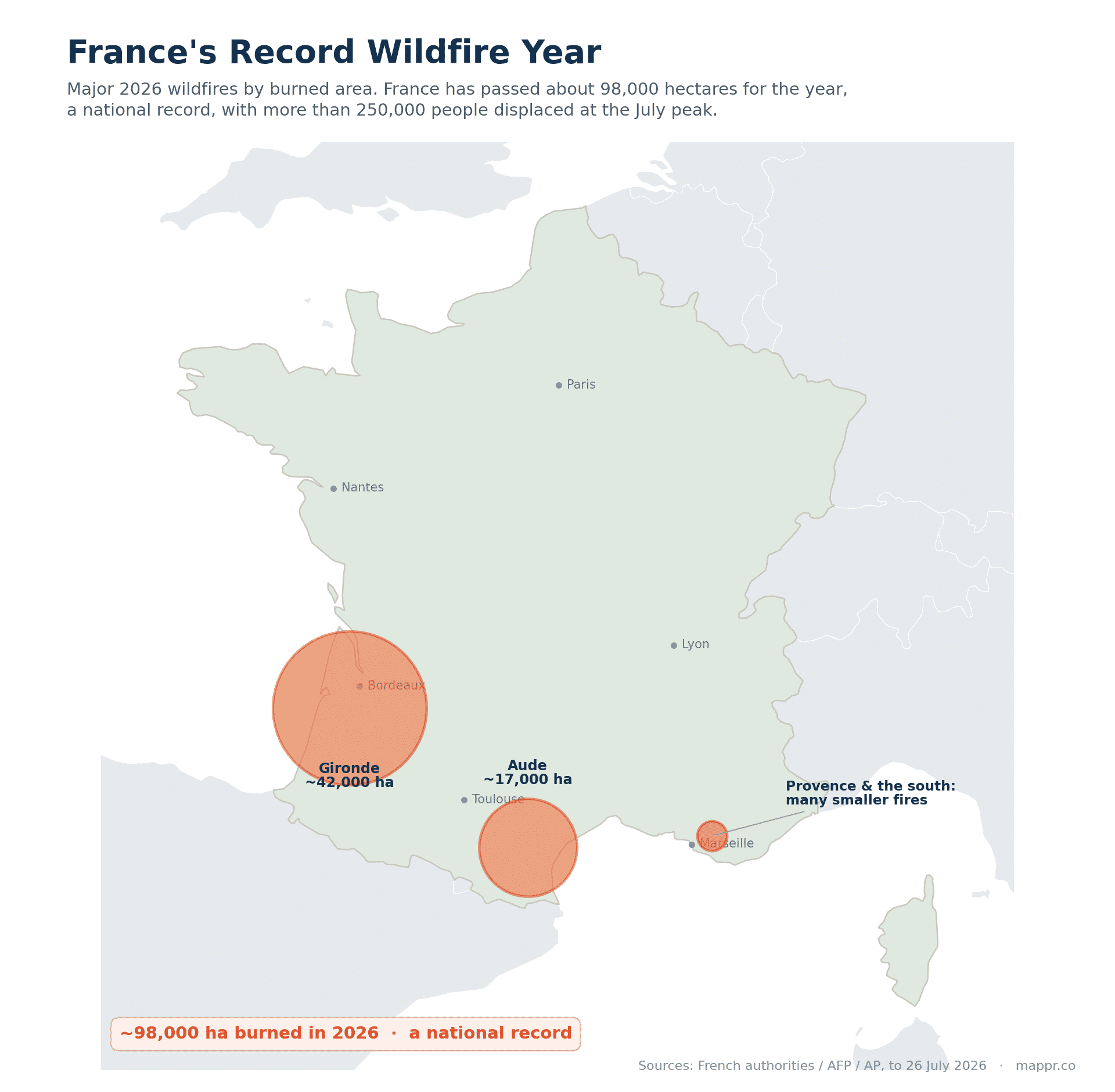
Elsewhere across Europe
Portugal has recorded around 30,000 hectares burned across thousands of ignitions, with a large fire near Vouzela sending a smoke plume some 620 km long. Greece has fought fires near Thessaloniki, west of Athens and in the central Fthiotida region, where a man and his 12-year-old son died.
In Italy, fires intensified sharply in late July, and on 23 July a firefighter, Alessandro Marchi, died responding to a blaze at San Cataldo in Sicily, where highs above 40 C and strong winds drove hundreds of fires and around 6,000 responders were deployed. Outside the EU, Turkey has logged nearly 50,000 hectares burned.
Greece became the deadliest front of the week. Two firefighters were killed on 29 July when they were trapped in their vehicle while moving between fire fronts near Krya Vrysi, in the Rethymno district of Crete, and a third died the same day in a separate fire in the Peloponnese.
The fire service said the two men on Crete fell in the line of duty; one was a seasonal firefighter and the other a five-year veteran. About 125 firefighters, four helicopters and four water-dropping aircraft worked the blaze, which was driven by gale-force winds.
Krya Vrysi and two neighbouring villages were evacuated as the flames pushed towards the coastal town of Agia Galini. The three deaths take the season’s firefighter toll to six, after two in France on 21 July and one in Sicily on 23 July.
Turkey had fires running across six provinces on 29 July: Muğla, Antalya, Manisa, Balıkesir, Yalova and Kütahya. The most serious was at Seydikemer, where 65 people from 43 households were moved out and the intensive care and palliative units of the state hospital were evacuated to Fethiye.
That fire alone drew 373 personnel, five aircraft and 12 helicopters. Smoke closed the main highway between Antalya and Fethiye and the Kemer to Kumluca road.
Crete then produced the biggest evacuation of the week. About 8,000 people were moved out overnight into 30 July from Agia Galini, Agios Pavlos, Triopetra and the mountain village of Krya Vrysi, ahead of a fire front more than 15 km long.
Winds of up to 102 km/h grounded the water bombers, and the national observatory logged shears of 125 km/h near Rethymno. More than 200 firefighters and 53 engines worked the blaze, which burned mostly forest and farmland rather than villages.
Some coastal hamlets could not be reached by road. Police and the coast guard used four patrol boats, one of them from the EU border agency Frontex, alongside about 40 coaches and intercity buses.
Two more Greek islands caught. On Paros a fire in the Kampi area forced about ten villages out, with 66 firefighters and four forest commando teams, while on Lesbos a blaze at Plomari burned some 100 hectares before conditions improved.
Greece went into 31 July with near-maximum fire alerts for Crete, greater Athens, the eastern Peloponnese and most of the Aegean islands.
Hundreds of firefighters were still working outbreaks on the mainland, on Crete and on Paros through 31 July, with gusts close to 100 km/h keeping aircraft on the ground. Flare-ups continued in southern Rethymno even as other sectors came under control.
Turkey has fought 115 fires since 29 July and brought 110 of them under control, across Antalya, Muğla, Balıkesir, Yalova, Kütahya and Çanakkale. The Yalova, Kütahya and Çanakkale fires are out, while Antalya, Muğla and Balıkesir are still burning.
At Seydikemer 408 homes were evacuated and 703 people plus about 100 animals moved, with 45 patients transferred from the state hospital and 55 buildings damaged across six neighbourhoods.
Another 210 homes were cleared at Altınoluk in Balıkesir and ten houses were destroyed at Kumluca. Turkey has committed more than 1,100 personnel, 410 ground vehicles and over 25 aircraft, and access to the Olympos ruins was closed.
Greece became the continent’s hardest front on 1 August. About 60 forest and agricultural fires broke out in 24 hours, and the fire service put maximum alerts on greater Athens, parts of the Peloponnese, Crete and central Greece.
The worst was at Porto Germeno on the Gulf of Corinth, about 70 km northwest of Athens. Nearly 500 firefighters worked it, helped by French and Romanian crews, in winds recorded at up to 130 km/h that repeatedly grounded the water bombers.
Up to 150 homes there are believed to have been damaged, and the wildfire meteorologist Theodore Giannaros said the burned area appeared to exceed 4,000 to 5,000 hectares. About 300 residents who had ignored evacuation orders were taken off the coast by boat.
Emergency 112 messages ordered Porto Germeno, Livadostra and Domvraina out. Crews also fought fires in the Kareas district of northeast Athens, at Haidari west of the capital, and in the southern Peloponnese, where three villages and two summer camps were evacuated.
Greece went into 2 August with extreme fire risk flagged for Attica, Boeotia and Evia. Prime minister Kyriakos Mitsotakis warned that August is traditionally a difficult month and blamed many of the new starts on gross negligence.
Then the fire killed. Two firefighting helicopters collided over Psatha in western Attica on 2 August; one exploded and fell in flames, killing a Greek and a Danish crew member, while the Greek and British crew of the second aircraft got out with light injuries.
Both Bell machines were leased by the fire service and had taken off from Elefsina military airport. An investigation into the cause has been opened.
The scale of the blaze also became clearer. Copernicus EMS satellite data processed by the National Observatory of Athens put about 11,100 hectares burned across the Attica and Boeotia fires by 12:05 on 2 August, some 8,080 of them in the Porto Germeno fire.
More than 100 homes have been destroyed and over 1,000 people evacuated, more than 250 of them lifted off the beaches by boat. The fire service traced the ignition to sparks from a faulty power line carrying electricity from a private wind turbine installation.
An electrical engineer and a contractor have been charged with felony arson and an arrest warrant issued for the owner of the wind company. Two fronts were burning by 2 August: east towards Vilia, and south from Psatha and Veniza towards Megara, a town of about 30,000.
The operation stood at 496 firefighters, 22 ground teams and 134 vehicles across Attica and Boeotia, reinforced by 23 French and 23 Romanian firefighters with four vehicles each. Eighteen helicopters flew while the wind kept fixed-wing aircraft down.
Two other Greek fronts opened. On Kefalonia a fire at Pastra pushed villages towards Argostoli in three waves of 112 alerts and a 44-year-old was arrested on suspicion of starting it, while at Skoloma in Fokida 64 firefighters and 15 vehicles worked seven evacuated settlements.
Five water bombers and five helicopters went up at first light on 3 August as the wind eased. Active hot spots were concentrated around Porto Germeno and Psatha on Mount Cithaeron and on Mount Patera northeast of Megara, and three further evacuation orders went out that morning.
The fire then turned on Megara. Through the afternoon of 3 August flames reached the Agia Skepi settlement at Kandili, above the town’s industrial zone, and a barrage of 112 messages ordered out Kandili, Ano Vlychada, Agios Konstantinos, the industrial zone and Papa Perivoli.
Psatha was told at 17:11 to evacuate towards Megara, and Loumba, Morfeika and Ano Alepochori were alerted again. The monastery of Agia Skepi and a solar installation were saved, and at Agios Nektarios the fire stopped metres short of houses.
Attica, Boeotia and Evia were on category 4 very high fire danger that day, with 450 firefighters, 126 engines and 22 forest commando teams committed. Officials in Megara later described total destruction of homes and businesses in the worst-hit quarters.
The scale is clearer now. Copernicus satellite mapping put about 13,290 hectares burned across Attica and Boeotia by 12:16 on 3 August, against 11,100 hectares the previous midday.
The fifth day brought relief. On the morning of 4 August the fire service spokesperson Effi Papavrammopoulou reported only smouldering points at Agios Nektarios, Agia Paraskevi and the Megara industrial zone, leaving one live front from Psatha towards Loumba.
A re-ignition broke out in pine forest about two kilometres north of Loumba and aerial drops resumed at first light. More than 556 firefighters, 29 ground teams and 141 vehicles were deployed, with the hours after 13:30 flagged as the riskiest.
Through 4 August the fire ran on three sectors: north towards Kryo Pigadi, Agios Nektarios and Mount Cithaeron, south towards Psatha, Loumba, Veniza and Zachouli, and southeast towards Kandili, Moni Kamara and Megara. Attica, Evia, Chios and Psara were on category 4 fire danger for 4 and 5 August.
The sixth morning brought the first pause. On 5 August the fire service reported no active front, with crews working smouldering points and watching three places for re-ignition: between Psatha and Loumba, at Kandili above Megara, and around Agia Paraskevi and Agios Nektarios.
The operation stood at 575 firefighters, 29 ground teams and 150 vehicles, including 26 Romanian crew with five vehicles and 23 French crew with four sent through the EU Civil Protection Mechanism. Four helicopters resumed water drops at dawn.
The scale grew again with the satellites. Copernicus mapping of imagery from the morning of 4 August put 144,243 stremmata burned, about 14,424 hectares, against 132,900 stremmata a day earlier.
Of that total, 113,277 stremmata are in the Porto Germeno fire spanning Attica and Boeotia and 30,966 in the Xironomi fire in Boeotia. The formal damage assessment starts once the fire is declared controlled.
Albania opened a front of its own on 5 August. Crews worked a fire in the southern Mallakastër region that moved about 15 families out with their livestock and pets near the village of Riban, while a second blaze south of Gjirokastër, probably started by lightning, burned across rocky mountain ground.
Portugal closed out its own emergency. The fire that started at Valpaços in the Vila Real district was declared controlled at about 04:40 on 1 August, having burned roughly 16,000 hectares and spread into Mirandela, Vinhais and Macedo de Cavaleiros.
Around 1,000 personnel, 300 vehicles and 11 aircraft worked it through a week of re-ignitions. Five people were slightly hurt: three firefighters, a National Republican Guard officer and a civilian.
Greece turned to compensation on 5 August. An interministerial meeting at the Maximos Mansion, chaired by Kyriakos Mitsotakis, approved full compensation for destroyed homes, up to €6,000 for household contents and basic needs, and rent subsidies for those who cannot go back.
Businesses get 70% of assessed damage to equipment and machinery. Employment contracts can be suspended with €534 a month for three months, tax and social security obligations are frozen for six months and property auctions for twelve.
The first official assessment put the burned area at about 111,000 stremmata, roughly 11,100 hectares, of which some 46,000 stremmata was forest. That is well short of the 144,243 stremmata Copernicus mapped from 4 August imagery, and the two counts have not been reconciled.
Cover was extended to Psatha and Alepochori at the request of local mayors. Helleniq Energy pledged €25 million for recovery, the four systemic banks offered loan suspensions and debt relief, and anti-erosion and flood works are due to start in mid-September.
The fire itself held. Six helicopters flew from dawn on 5 August, army tracked earth movers cut firebreaks and ministry teams began assessing damage, while the fire service warned that high temperatures in the subsoil can start new fires in almost no wind.
The case has moved to the courts. The mayor of Stylida, Ioannis Apostolou, whose construction company built the overhead line carrying power from the wind farm, was remanded in custody on 7 August along with a contractor and the owner of the wind farm.
All three are accused of arson and of damaging public utilities, and face more than ten years if convicted. Investigators found the line defective and concluded that sparks from two of its cables started the fire, and a fire had already broken out on the same line on 27 June.
The wind farm has been shut down. Authorities suspended its operation on 7 August, and more than 120 buildings and homes were damaged at Porto Germeno on the Gulf of Corinth.
Greece went back on alert for the weekend. Civil protection put Crete and the regional units of Chios, Samos and Ikaria on red code mobilisation for 8 August at category 4 fire danger, while Attica stays on red code over the risk of destructive flare-ups in the 31 July burn scar.
Italy’s season now has a figure attached. A WWF Italy report released on 5 August put the country at about 70,000 hectares burned for the year, more than twice its 20-year average, with close to a third of the fires running through nationally or EU-protected land, and six major fronts still active on 6 August.
The Attica fire now has a physics measure. The National Observatory of Athens FLAME pyrometeorology team reported on 8 August that the megafire burned 111,732 stremmata, about 11,173 hectares, in 91 hours from the morning of 31 July.
It released at least 380 terajoules of thermal energy, roughly the equivalent of six Hiroshima bombs. Nearly 34,000 stremmata went in 12 hours on the first night, close to 2,800 stremmata an hour, with mean winds above 80 km/h and gusts over 130.
Most of it burned in the dark. Some 61,500 stremmata, 55% of the total, were lost at night, which is unusual for wildfire behaviour and is a large part of why this one could not be held.
Greece stayed on guard into Sunday. Civil protection put Attica including Kythira, the units of Corinthia, Argolida, Arcadia and Laconia, Boeotia, Fthiotida and Evia, Lesbos, Chios, Samos and Ikaria, and the Cyclades on red code for 9 August.
Attica caught again on 10 August. A fire started that morning in low vegetation near the Agios Stylianos settlement at Kouvaras, in southeast Attica, and spread quickly in winds of about 7 Beaufort.
Two 112 messages went out, one of them ordering Agios Stylianos to leave. Lavriou Avenue was closed and businesses were damaged as the flames ran east onto higher ground.
The response was heavily international. The fire service put 197 firefighters, seven EMODE forest commando teams and 42 vehicles on it, including 23 French firefighters with four vehicles and 24 Romanians with five, backed by two aircraft and four helicopters.
Greece went on red code again for 10 August. Category 4 danger covered Attica including Kythira, Crete, Achaia, the Peloponnese units of Corinthia, Argolida, Arcadia and Laconia, Boeotia, Fthiotida, Fokida and Evia including Skyros, the North Aegean islands and the Cyclades.
The fire service held its second stage of operational readiness, with fire, police and army ground and air patrols reinforced across the areas at risk.
Portugal is busy but holding. Civil protection had 12 active rural fires and 743 personnel committed on 8 August, the worst of them a brush fire reported at 13:45 at Linhares, in Carrazeda de Ansiães in the Bragança district.
That one drew about 180 personnel, 48 vehicles and eight aircraft into ground that is hard to reach.
Portugal spent 9 August on two northern fronts. More than 180 personnel and seven aircraft worked a brush fire at Vila Pouca de Aguiar in the Vila Real district, which the local commander, Hugo Silva, called practically dominated with one active front left.
The Carrazeda de Ansiães fire came back. The blaze at Parambos reactivated at 15:45 with two fronts burning hard through forest, and reinforcements with water-bombing aircraft pushed it into the resolution phase by 17:30.
The Kouvaras fire was held. Greek civil protection reported the blaze under control with no active front by the evening of 10 August, with smouldering spots left behind and strong winds still a worry.
The damage was commercial rather than residential. Flames hit two businesses on the edge of the Agios Stylianos settlement, among them a poultry unit, after a 112 message went out at 08:30 telling residents to move towards Kalyvia Thorikou.
Greece went straight back on red code for 11 August. Category 4 danger covers Attica with Kythira, Achaia, the Peloponnese units of Corinthia, Argolida, Arcadia and Laconia, Boeotia, Fthiotida, Fokida and Evia with Skyros, Lesbos, Chios, Samos and Ikaria, and the Cyclades.
The wind is the reason. Northerly winds of 6 to 7 Beaufort are forecast to hold across eastern and southern Greece through 11 and 12 August, and fire service personnel in those units are on partial standby.
Italy’s trouble has moved north. Friuli Venezia Giulia counted 15 fires being fought, mopped up or watched across its four provinces at 18:30 on 10 August, a long way from the Sicilian fires of late July.
Four fronts were active: Monte Palavierte at Illegio, Monte Amariana at Amaro, the old quarry at Duino and San Martino del Carso at Sagrado. Two Canadairs, regional civil protection helicopters and an Italian Army helicopter worked them, and no evacuations were reported.
Friuli Venezia Giulia was still not clear on 11 August. The Canal Piccolo di Meduna fire at Tramonti di Sopra threw up fresh fumaroles and regional helicopters went back to it in the afternoon.
The list of fires being worked or watched ran from the Carso to the mountains: Monte Naiarda, Canal Grande di Meduna, Canal di Cuna, Monte Nero in the Val Saisera, Monte Festa, Monte Palavierte, Monte Amariana, Padriciano, Duino, Monte Grisa and Selz. The SS14 reopened after the Duino mop-up.
Greece went back on red code for 12 August, and the map grew. Category 4 danger covers Attica with Kythira, the Peloponnese units of Corinthia, Argolida, Arcadia and Laconia, Boeotia, Fthiotida, Fokida and Evia with Skyros, the North Aegean and the Cyclades.
Eastern Macedonia and Thrace was added, taking in Kavala, Thasos, Xanthi, Rodopi and Evros with Samothraki. The fire service held its second stage of operational readiness, with air, police and army patrols stepped up.
Zakynthos had a busy day on 11 August. Three fires broke out on the island, at Glyka Nera, Volimes and Marathia, the last of them started by a burning vehicle, and the Volimes blaze was contained.
Greece raised the alarm a level for 13 August. The General Secretariat for Civil Protection declared category 5, extreme danger and a state of alert, for Attica, Central Greece with Boeotia and Evia, Corinthia and Argolida in the Peloponnese, and Lesbos in the North Aegean.
Much of the rest of the country sits at category 4. Fire services in the category 5 regions are on general alert and those at category 4 on partial alert, with air, police and army patrols and preventive bans on traffic and visits in national forests.
The climate crisis and civil protection minister, Evangelos Tournas, convened the civil protection coordination body and put every state service, region and municipality on heightened readiness.
Italy’s northeastern fires are still running. Friuli Venezia Giulia counted about 18 fires being fought, mopped up or watched on 12 August, five in Pordenone province, eight in Udine and four between Trieste and Gorizia.
The Carso is the hardest part. Crews worked the perimeter between Monfalcone and Duino from the air with a regional helicopter, an Italian Army machine out of Casarsa and the Canadair CAN 31.
Monte Amariana would not stay out. The fire at Amaro looked contained during the afternoon of 12 August before restarting around 17:00, with three regional helicopters flying across the region and Monte Palavierte at Tolmezzo in mop-up.
Greece’s worst day landed on the Kassandra peninsula. A fire broke out at Siviri in Halkidiki on 13 August, driven by strong winds into what reports described as a three-kilometre wall of flame up to 30 metres high.
The beach had to be cleared by sea. Coast guard vessels, fire service boats, fishing boats, private craft and a passenger ferry took 481 people off Siviri, landing 285 at Sani Marina and 196 at Thessaloniki port.
Siviri and Fourka were both told to go by 112 alert. About 142 firefighters and 51 vehicles worked the fire with aircraft and helicopters, and two firefighters went to hospital, one with a leg injury and one with breathing difficulties.
The damage is to infrastructure as much as homes. Siviri’s sewage treatment plant was badly damaged and its theatre extensively so, and the fire is blamed on a spark from an electricity pole brought down by the wind.
There was no active front by 14 August. Crews stayed on the peninsula watching for flare-ups after roughly 200 hectares had burned.
The rest of the country was busy too. Greece counted about 40 forest fires in 24 hours to late on 13 August, nine of them still uncontrolled, with fronts at Drymonas in Aetolia-Acarnania and Akontio in Boeotia and a 112 standby alert at Vartholomio in Ilia.
The alert stayed at the top of the scale for 14 August. Civil protection held category 5, extreme danger and a state of alert, for Attica, Central Greece with Boeotia and Evia, and Corinthia and Argolida, with winds of force 7 to 8 and locally force 9.
The holiday made it worse. Zakynthos banned traffic in forests and Natura zones from 14 to 15 August over the Assumption weekend, and Athens closed Lycabettus Hill, Pedion tou Areos and Finopoulos Hill.
Greece eased a step for 15 August. Civil protection dropped to category 4, very high danger, but spread the red code across Attica with Kythira, Corinthia, Argolida and Laconia, Achaia and Ilia, Boeotia, Fthiotida and Evia with Skyros.
The rest of the map went with it. The Sporades, the North and South Aegean, Crete, Halkidiki with Mount Athos, and Kavala, Thasos, Xanthi, Rodopi and Evros with Samothraki were all included.
Crete produced the evacuation. A 112 message went out about 19:30 on 14 August for Fotinari and Souda in the Rethymno district, routing residents to the coast at Koraka and Rodakino.
There was no active front there by the end of the day. It took 89 firefighters, three walking teams, 25 vehicles, four helicopters, water trucks, coast guard boats and a Frontex vessel.
Kos had the other fire. A blaze at Pyli that started on the afternoon of 14 August was contained by the morning of 15 August, with seven firefighters flown in from Rhodes to reinforce the island crews.
A fire at Varda in Ilia was held the same day, with 20 firefighters, seven vehicles and three aircraft on low vegetation.
Halkidiki stayed staffed. Some 227 firefighters, 57 vehicles, six aircraft and a helicopter watched the Siviri and Fourka ground on 14 August, with the provincial road between the two villages closed in both directions.
Italy’s fires jumped to the lakes. A blaze on Monte Goj above Como started on the afternoon of 13 August and drove about 50 people out of their homes overnight, with more than 100 firefighters on containment.
Two Canadairs went in from 07:00 on 14 August. In the northeast, crews cut a firebreak on Monte Amariana in Carnia with a Forestry Service Canadair, and three helicopters worked a fire at Samugheo in Sardinia.
Croatia had the week’s deadliest fire. A blaze reported near Lokva Rogoznica at 20:15 on 13 August ran overnight into the resort town of Omiš, burning about 900 hectares by midday on 14 August according to the Croatian Firefighting Association.
It reached houses. Police found a woman’s body in burnt scrub on 14 August, 40 people were treated in hospital with seven in a life-threatening condition and ten in intensive care, and about 1,200 residents and tourists were evacuated.
The fire chief, Slavko Tucaković, called it one of the worst in Croatia’s history, saying houses, cafes, restaurants, cars and boats had been damaged. The Red Cross opened shelters at Omiš, Split and Makarska.
Italy declared a regional emergency. Friuli Venezia Giulia set aside 1.7 million euros for the Monte Amariana fire at Amaro, which had touched about 450 hectares, more than 100 of them in Amaro itself.
Como was still mopping up. Crews kept 55 firefighters and 15 vehicles on Monte Goj through 15 August, using thermal cameras to find hot spots and flying helicopters again at first light.
Greece expects a break. Forecasters had the winds easing from the afternoon of 16 August, after gusts of force 8 to 9 over the Aegean across the Assumption weekend.
The break came too late for Salamina. Two fires broke out within half an hour on the island west of Athens on the afternoon of 16 August, one at Peristeria and one at Selinia that ran towards Kaki Vigla.
The Peristeria fire killed two. Police recovered the bodies of an elderly couple from the area where it is believed to have started, and eight people were treated for burns at the Salamina health centre.
The beaches were cleared by sea again. Four separate 112 messages ordered evacuations, and at least 364 people were taken off Saterli and Kolones by coast guard boats and private craft as houses caught fire inland.
About 260 firefighters worked the island. They had ground teams, vehicles, aircraft and helicopters, with reinforcements rushed over from the mainland against near gale-force winds.
The Selinia fire was out by the evening. Scattered pockets were still burning at Peristeria, where a resident said the fire had started in an adjacent plot filled with rubbish.
Skyros had the weekend’s other Greek fire. A blaze that broke out on the Aegean island on 15 August burned into a second day, forcing two small communities out, with about 100 firefighters and close to a dozen aircraft and helicopters on it.
The mayor expected a quick end. Kyriakos Antonopoulos told state broadcaster ERT he believed the fire would be fully extinguished within the day, and said no inhabited areas were under threat on 16 August.
Greece was busy everywhere else too. Thirty-four fires broke out across the country in the 24 hours to that morning, with fire commandos cutting firebreaks by machine on ground too broken for engines.
Montenegro has joined the map. Fires spread near Herceg Novi, at Bijela and Baošići, and at Ulcinj from 14 August, with more reported near Bar, Nikšić, Kolašin and Cetinje.
Copernicus was activated for it. The EU mapping service was called in at 22:00 UTC on 14 August for burnt-area delineation and damage assessment, after strong winds drove the fires towards homes and some residents were moved out as a precaution.
Skyros ended up small. Satellite mapping of 16 August imagery put the burn at 3,636 stremmata, about 364 hectares, and the fire service was left chasing scattered hot spots rather than a single front.
Greece is still starting dozens of fires a day. The fire service counted 47 rural and forest fires in the 24 hours to the morning of 18 August, 37 of them caught in the initial stage.
The new ones came fast on 18 August. Crews worked a blaze at Thiva in Boeotia with two aircraft and a helicopter, a double front at Volos that triggered a 112 alert at 18:11, and another start on Salamina two days after the deadly one.
The tempo eased slightly on 19 August. The fire service counted 39 rural and forest fires in the 24 hours to 18:00 that day, 36 of them caught in the initial stage and three still being worked.
The mountains took one of them. A forest fire broke out at the Avtia site near Vovousa, in the Zagori district of Ioannina, on the afternoon of 19 August, drawing 12 firefighters, a walking team of the 5th EMODE, two vehicles and a helicopter.
Portugal has passed 60,000 hectares. The national rural fire management system counted 60,572 hectares burned and 6,572 rural fires between 1 January and 18 August, about 13% more fires than by the same point in 2025.
The area is the smaller story there. That is roughly a quarter of the 245,760 hectares burned by the same date last year, which makes 2026 the fifth worst year of the decade in Portugal for burned area, behind 2017, 2025, 2016 and 2022.
Portugal kept climbing. ICNF counted 63,347 hectares burned and 6,666 rural fires to 19 August, 6,761 hectares more than at the 15 August reading.
Vila Real carries the most. The district had 13,562 hectares burned to 15 August, ahead of Bragança on 9,909 and Viseu on 8,325, with Valpaços, Mirandela, Águeda and Vouzela the worst-hit municipalities.
Greece has quietened. The fire service counted 25 rural and forest fires in the 24 hours to 18:00 on 20 August, all of them caught in the initial stage, against 39 the day before.
The biggest was in Laconia. A forest fire at Kremasti, in the municipality of Evrotas, drew 35 firefighters, nine vehicles, three aircraft and a helicopter.
The danger map has moved east. EFFIS forecast very extreme fire danger for 20 to 26 August over a large area centred on Romania and Hungary, with extreme conditions across the wider Balkans, central and southern Italy, Ukraine, Russia and the south of Ireland.
Greece ticked back up. The fire service counted 29 rural and forest fires in the 24 hours to 18:00 on 21 August, 19 caught in the initial stage and ten still being worked, against 25 the day before.
The north took one of them. A forest fire at Katafyto, in Kato Nevrokopi in the Drama regional unit, drew 32 firefighters and four aircraft on the afternoon of 21 August, with crews also out at Chranoi in Megalopolis and Mesochori in Messinia.
Greece held level on 22 August. The fire service counted 29 rural and forest fires in the 24 hours to 18:00 that day, 28 of them caught in the initial stage and one still being worked.
Then it jumped. Thirty-seven rural and forest fires broke out in the 24 hours to 18:00 on 23 August, 26 caught at the start and eleven still being worked, the highest daily count since 19 August.
Two needed holding overnight. Crews got partial control of an agricultural and forest fire at Elateia in Phthiotis and a forest fire near Agios Nikolaos in Laconia, with the arson prosecution division looking at the causes.
Greece jumped again on 24 August. The fire service counted 49 rural and forest fires in the 24 hours to 18:00 that day, 38 caught at the initial stage and eleven still being worked, against 37 the day before.
The ones that held out were spread wide. Crews stayed on a fire at Kalorrema near Metsovo, another at Aspro in Paionia in Kilkis, and a third at Tragano in Ilia that drew 24 firefighters and three aircraft.
The risk map has eased even so. Civil protection forecast category 3, high danger, for 35 regions on 25 August, with no part of the country at category 4 or 5.
Greece came back down on 25 August. The fire service counted 39 rural and forest fires in the 24 hours to 18:00 that day, 24 caught at the initial stage and 15 still being worked, against 49 the day before.
Two of them were awkward. A fire took hold in low vegetation and dumped waste at Elliniko on Salamina in the middle of the afternoon, throwing up black smoke and a run of explosions from an old tip.
It burned at the edge of the naval base. The flames took a corner of the yard where scrap is stored, with no ammunition, fuel tanks or ships nearby, and 112 messages sent Ano Vasilika and Nea Salamina towards Akti Karaiskaki.
About 80 firefighters worked it with 25 vehicles, three aircraft and three helicopters, backed by municipal water trucks. The deputy mayor said no homes were threatened and nobody was hurt.
The other emptied a village in Boeotia. A fire in low vegetation between Tsoukalades and Agios Vlasios started at about 16:45 on 25 August, and a 112 message at 18:14 sent Tsoukalades towards Livadeia.
It was much better by morning. At 07:34 on 26 August crews were on smoking ground rather than flame, with 85 firefighters, four walking groups, 28 vehicles and two helicopters up at first light.
The risk map has ticked back up. Civil protection put parts of western Greece and the Ionian at category 4, very high danger, for 26 August, with category 3 over much of the Peloponnese, central Greece, Thessaly, Macedonia, Crete and the islands.
The next day was quieter again. The fire service logged 35 rural and forest fires in the 24 hours to 18:00 on 26 August, down from 39, with 30 caught at the initial stage and five still being worked.
The risk has swung south and east. For 27 August civil protection put Attica, Evia, the north Aegean islands of Chios, Samos and Ikaria, Crete, and the Cyclades along with Kalymnos, Kos and Karpathos at category 4, very high danger.
Crete went to the top level as a whole. The island’s regional civil protection authority applied category 4 across Heraklion, Lasithi, Rethymno and Chania, closing named forests, gorges and hiking trails for the day.
Greece has taken over as the active front. A fire in low vegetation at Karystos on Evia was reported to the fire service at about 11:30 on 2 September and spread quickly in winds gusting to 7 Beaufort.
Three 112 messages followed. An alert went out at 11:45, Theatroupoli was sent towards Karystos at 12:22, and OSMAES and Erodios were moved as a precaution at 15:05.
The response was heavy for a low-vegetation fire. At its peak it drew 63 firefighters with three walking teams, 22 vehicles, 13 aircraft and five helicopters, backed by municipal and regional water trucks.
A second fire started the same afternoon. It broke out at Mytikas in the municipality of Thiva at about 13:50, close to a photovoltaic park, and ran south until army bulldozers could cut firebreaks before nightfall.
It pulled in 20 aerial units. Eighty firefighters and volunteers worked it with walking teams from the 1st and 4th EMODE, 25 vehicles, 12 aircraft and six helicopters, plus two Chinooks from the armed forces.
Both were better by 3 September. Crews stayed on scattered hot spots at Karystos and Mytikas, and a third fire at Syneti on Andros, reported early that morning, was contained after initial attack with two helicopters.
The risk map went orange for 3 September. Civil protection put the Cyclades, Lesbos, Chios, Psara, Samos, Ikaria and parts of Attica and Evia at category 4, very high danger.
Italy has quietly passed last year. EFFIS had 91,408 hectares mapped in Italy to 26 August from 484 fires of 30 hectares or more, well above the 84,348 hectares it recorded for the whole of 2025.
Puglia is where it is burning now. A fire started at about 17:00 on 25 August near the old powder magazine at Poggiorsini and ran into the Alta Murgia national park, spreading towards Gravina in Puglia, Corato and Spinazzola.
The first official figure was about 500 hectares. On the morning of 26 August the fire brigade had 12 crews and 15 vehicles from the Bari command on it, with help from the Foggia and Taranto commands and the Molise regional mobile column.
The air response worked off a reservoir. Three Canadairs and two helicopters flew repeated drops, loading from the Locone dam, while a strong wind that kept changing direction made the fire hard to hold.
It burned across military ground. The flames took in the army firing range and the area of the former powder magazine at Poggiorsini, where the fire is thought to have started.
Local accounts put it far higher. Reporting from Corato on 27 August described a front some 20 kilometres long and about 2,000 hectares of pasture, woodland and farmland gone, with farmers saying the real figure could be more than double.
The fire is believed out. Crews thought they had extinguished it on 26 August, and one farm alone reported losing roughly 100 hectares of grazing.
Coldiretti set it against the season. It counted 7,879 hectares burned in Puglia between 1 June and 22 August across 89 serious fires: 2,645 hectares in the province of Bari, 2,341 in Foggia and 1,655 in the Barletta-Andria-Trani area.
The forecast had flagged it. EFFIS put central and southern Italy in extreme fire danger in its outlook for 20 to 26 August, with the very extreme band sitting over Romania and Hungary.
Portugal is the other way round. EFFIS had 64,116 hectares mapped there to 26 August from 189 fires, well short of the 278,917 hectares it recorded across the whole of 2025.
The national count says the same. ICNF puts about 67,000 hectares burned between 1 January and 31 August, against more than 254,000 hectares in the same period of 2025, a fall of about 74%.
The figures are provisional. Even at that level it is Portugal’s fifth worst year for area burned to the end of August since 2016, and late August rain is credited with much of the improvement.
Romania is where the danger has gone. EFFIS has put it at the centre of very extreme fire danger since 20 August, and the satellites have mapped 16,055 hectares there this year from 134 fires of 30 hectares or more, against 129,443 hectares in 2025.
The fires are many and small. Bihor county alone counted 14 vegetation and forest fires in the 24 hours to 25 August, burning more than 30 hectares across a dozen villages, from waste ground to forest litter and young acacia.
The county emergency inspectorate blamed the conditions. It said the run of fires came in a period of high temperatures, scarce rain and very dry vegetation, where a small source can spread fast enough to threaten nearby homes.
Further north
The fires have also pushed unusually far north. In the United Kingdom, a wildfire on Conwy Mountain in North Wales triggered a major-incident declaration on 12 July and the evacuation of 36 homes before it was brought under control the next day, while a grass fire beside a railway line in the London district of Walthamstow burned a house and dozens of gardens.
In Germany, a wildfire in the Müritz National Park in the country’s northeast has burned for nearly a week, spreading to about 388 hectares by 19 July, with some 370 firefighters, forestry workers and soldiers deployed and active firefighting confined to part of the area because of unexploded ammunition in the forest floor.
Britain has now had a major incident of its own. Suffolk Fire and Rescue declared one after crews were called shortly after 17:30 on Wednesday 29 July to a wind-driven fire on Dunwich Heath, near Leiston on the Suffolk coast.
By the Thursday afternoon it had burned about 150 hectares, roughly 210 football pitches, with more than 100 firefighters, 18 engines and a helicopter scooping seawater. Homes and a caravan park were evacuated and no injuries were reported.
The heath lies about three miles from the Sizewell B nuclear station. Suffolk Fire and Rescue said neither Sizewell B nor the Sizewell C site under construction was considered to be at risk.
By 21:45 on 1 August the service called the situation stable, with firebreaks up to 12 metres wide completed around the whole perimeter. Crews were cut back to six appliances overnight to watch for hot spots, and recovery planning had begun.
It is not over. Suffolk Fire and Rescue’s 15:50 update on 2 August kept Dunwich Heath a live major incident, with ten appliances and support vehicles by day, six overnight and 90 to 100 personnel on site.
A helicopter is working ground crews cannot reach, roads and footpaths stay closed and the service expects to be there well into the following week, with an amber heat-health alert in force. About 150 hectares have burned, no property has been lost and nobody has been hurt.
At the peak it took 18 engines and more than 120 firefighters, a helicopter dropping 1,000 litres a pass, Unimogs, drones and quad bikes, with mutual aid from seven neighbouring services. About 200 caravans at Cliff House Holiday Park were protected, no property was lost and nobody was hurt.
Dunwich Heath was still a major incident on 3 August, though Suffolk Fire and Rescue called it stable. Ten pumping appliances worked by day and six overnight, drones found hot spots, a helicopter flew again and local farmers kept supplying water.
The service began arranging controlled access to affected properties and kept an information centre open at Westleton village hall. The RSPB visitor centre is shut all week, roads and footpaths stay closed, and an amber heat-health alert is in force.
The incident held on 4 August. Suffolk Fire and Rescue’s 10:00 update kept Dunwich Heath under major incident arrangements but called it stable, with crews and drones monitoring and extinguishing hot spots and National Resilience resources still in support.
By the 18:30 update crews had made good progress despite high temperatures, low humidity and stronger winds, with no significant spread and only isolated fires around the perimeter. Resources were cut back overnight and the Westleton information centre had closed the night before.
The heath will now stay shut for weeks. Suffolk Fire and Rescue kept the major incident in place in its 16:15 update on 5 August, and Natural England excluded public access to the open access land and the King Charles III England Coast Path around Dunwich until 22 August.
The reason is underground. Significant heat remains beneath the surface where organic material is still smouldering, which brings a risk of burns and of ground giving way.
The major incident ran on into a ninth day. Suffolk Fire and Rescue’s 16:40 update on 6 August kept Dunwich Heath under major incident arrangements but called the situation stable, with crews still finding and extinguishing hot spots.
Better weather let them go on the front foot. Ten pumping appliances, four 4×4 vehicles and two Unimogs were on site, with National Resilience resources still in support.
The fire is shrinking. Suffolk Fire and Rescue put the active fire area at about 112 hectares on 8 August, down from the 150 hectares burned at its height, and warned that the hot weather forecast for the weekend may bring further challenges.
It held over the weekend. Suffolk Fire and Rescue’s 16:00 update on 9 August kept Dunwich Heath a stable major incident at about 112 hectares, with four pumping appliances and seven 4×4 vehicles on site, three of them National Resilience assets.
The weather stayed awkward, with higher temperatures and shifting winds, and crews were still finding and extinguishing hot spots. The service said resource levels would be reviewed for possible reduction over the coming week.
The review came quickly. Suffolk Fire and Rescue stood the Dunwich Heath major incident down on 10 August after a fresh fire risk assessment, twelve days after declaring it on 29 July.
It is not finished. Crews stay on the heath damping down and watching for hot spots, the National Resilience crews drafted in from other services began scaling back at 17:00, and the Dunwich Road from Westleton reopened at the same time with traffic controls.
The chief fire officer, Jon Lacey, called the stand-down an important milestone but added: “I want to be absolutely clear that this incident is not over.” The heath stays shut because fire can sit hidden underground for a long time.
The surrounding villages are open for business, and East Suffolk Council has taken over multi-agency recovery coordination.
Dunwich Heath is quiet but not finished. Suffolk Fire and Rescue’s 16:00 update on 11 August reported a drone sweep of the perimeter that turned up a single small hot spot, which crews damped down.
The service stressed it is still an ongoing incident even without major incident status. The Dunwich Road from Westleton reopened the previous evening, and public access to the heath stays closed.
Suffolk Fire and Rescue has now left the site. The last crews came off Dunwich Heath at 17:00 on 12 August after 14 days, and responsibility for the land went back to its owners an hour earlier.
The incident has moved into a re-inspection phase. Level 2 officers from the North District are checking the site through Friday evening, and a final visit is due on Monday to decide whether to record a stop message.
It is still a fire scene. The service is discouraging visits and the heath stays closed to the public.
The cost is landing on the local economy. Businesses a few miles from the heath report trade down by roughly a third with the roads closed, and the National Trust’s recovery appeal had raised £350,000 by 7 August.
The drought is reaching the fields as well. Reuters reported on 5 August that Britain’s cereal harvest is on track to be the worst since comparable records began in 1984.
The wider British picture is deteriorating. Half of England is now in drought, the country is in its fourth heatwave of the summer, and 2,877 heat-related deaths had been recorded by 30 July, nearly double the 2025 total and close to the record 2,985 set in 2022.
On the burned-area count Britain is having its worst year on record. A Euronews reading of EFFIS data published on 13 August puts 22,206 hectares burned in the UK by week 31, against a 14-year average of 12,311.
Germany is above par as well, at 6,045 hectares against an average of 3,098. Both totals are small next to Iberia, but they are the clearest sign that the fire map has moved north.
Britain has now lost homes. A wildfire that began shortly before 13:30 on 13 August near Racecourse Lane in Stourbridge, in the West Midlands, destroyed 19 houses and damaged 18 more.
It ran through more than 500 acres. West Midlands Fire Service sent 12 engines and about 60 firefighters at first, with more than 100 committed to the wider response.
The chief fire officer, Simon Tuhill, called it one of the most significant incidents the service has attended, and said he had never seen scenes like it in Britain, with a whole house gutted.
A child and three firefighters were taken to hospital and six more people were treated for smoke inhalation. Across the day paramedics treated 54 people and 19 were admitted.
Other fires ran the same day. Four homes were destroyed at Goldenhill in Stoke-on-Trent, where arson arrests followed, and a blaze at Highters Heath in Birmingham damaged terraced houses.
The weather was the trigger. Kew Gardens in London hit a provisional 38.1°C on 13 August, the UK’s hottest day of 2026, under an amber extreme heat warning across the West Midlands and much of the south and east.
The drought has widened with it. Euronews put nearly three-quarters of England in drought on 14 August, and the government called in the military and banned disposable barbecues.
Germany now has a fire to match. A blaze that broke out on the afternoon of 13 August at Hürtgenwald, in the Eifel in North Rhine-Westphalia, had spread to about 300 hectares by the morning of 15 August.
It is probably the state’s largest on record. The state agriculture minister, Silke Gorißen, said it was a scale North Rhine-Westphalia had not dealt with in decades.
About 2,000 people were evacuated from the Gey district in the early hours of 14 August. No house has been lost and nobody has been hurt, and the Düren district let residents go home at 21:47 on 15 August.
The ground itself is dangerous. The Hürtgenwald was a 1944 battlefield, and unexploded wartime ammunition began detonating in the burn area after midnight on 14 August, closing zones to firefighters.
The response went national. Chancellor Friedrich Merz called the district administrator to thank crews, and the federal government released more aircraft, taking the fleet to ten helicopters from the federal police, state police and the Bundeswehr.
There was progress by the evening of 15 August. Minister-president Hendrik Wüst said the night had stabilised the situation and there was a first hope of bringing the fire under control, with crews watching for storm cells that could fan it again.
Other German states were burning too. A large fire near Langenscheid in the Vordereifel was brought under control on the evening of 14 August, and hundreds of firefighters worked a blaze at Ottweiler in Saarland.
Hürtgenwald then steadied. The Düren district called the situation static on 16 August with the fire held at about 300 hectares, still the largest in North Rhine-Westphalia since records began in 1991.
The military went home that evening. The Bundeswehr ended its support at 19:00 on 16 August, after four armoured recovery vehicles, four helicopters and about 457,000 litres of water dropped in 150 runs.
Somebody started it. North Rhine-Westphalia’s interior minister, Herbert Reul, said the fire had been caused by a person rather than the weather, and the investigation is continuing.
Wales is now Britain’s front. South Wales and Mid and West Wales fire and rescue services have both declared major incidents, and crews were working about 20 wildfires across the country on 16 August.
The army is carrying water. Around 200 military personnel were sent to south Wales under a military aid request, with 110 still on the ground on 16 August, mostly on logistics so firefighters could stay on the fire line.
The response went national on 14 August. The government sent an emergency alert to phones in England and Wales from about 19:00 telling people not to light fires, and told retailers to pull disposable barbecues from sale immediately.
Wales has stood one down. Mid and West Wales Fire and Rescue said shortly after 16:20 on 17 August that the Rhandirmwyn wildfire near Llandovery was under control and the major incident was over.
It had run for six days. Crews were called at about 12:45 on 12 August, the fire was upgraded to a major incident the next day at around 250 hectares, and the specialist firefighting helicopter has now been released while crews work the hotspots.
Hürtgenwald is under control. The Düren district had about 400 people on the fire by the afternoon of 17 August, down from a peak of roughly 1,800, with no open flames left but smouldering ground still being worked.
The operation is now closed. Kreis Düren ended the major deployment at 08:20 on 18 August and handed command to the municipality of Hürtgenwald and its volunteer fire brigade, cutting the number of responders sharply.
The work has not finished with it. District firefighters, state forestry staff and ordnance specialists are rotating through the burn to damp down hot spots, with infrared drones watching ground that still holds unexploded wartime ammunition.
Gey is nearly normal. The B399 between Gey and Kleinhau reopened at 15:30 on 17 August with a 50 km/h limit, and the village itself stays open to residents only with parking bans on several streets.
Hürtgenwald is out. The mayor, Stephan Cranen, said on 20 August that the fire had been extinguished, a week after it started, closing out the largest wildfire in North Rhine-Westphalia since records began in 1991.
The forest stays shut. It is closed indefinitely, both to stop new ignitions and to keep people away from trees left unstable by the fire.
EFFIS forecast very extreme fire danger over the British Isles, France and northern Iberia through 22 July, and the events of the following week, with France’s worst fires on the Atlantic coast rather than the Mediterranean, confirmed that the risk map now stretches well beyond southern Europe.
Belgium
Belgium had never seen a fire like this. A blaze that started in the early afternoon of Friday 14 August near Baelen, in the Hautes Fagnes nature reserve about 25 kilometres from the German border, had burned 1,600 hectares by early on 15 August.
That alone made it the biggest on record. EFFIS data show the previous Belgian maximum was a 2011 fire of nearly 1,400 hectares, and by 18:00 on 15 August the acting governor of Liège province put the area at about 2,700 hectares.
The terrain is the problem. The Hautes Fagnes is a peat bog and moorland reserve, and the authorities said its broken ground made it impossible to attack the fire with the usual resources.
Belgium activated the EU Civil Protection Mechanism. The crisis commissioner, Hadja Lahbib, said three helicopters and two water-bombing aircraft were sent, with Dutch and Czech helicopters and Swedish planes joining German and Luxembourg crews already on the ground.
The villages went out on 15 August. More than 600 people were moved from Sourbrodt and Bütgenbach, and a sports centre at Malmedy was turned into a Red Cross shelter.
It was still not under control on 16 August. Governor Hervé Jamar’s 08:00 report said the winds had changed direction several times overnight, forcing constant changes of plan, and that aircraft resumed at first light after being grounded in the dark.
No home has burned so far. Around 250 responders and 50 vehicles were committed, including 70 police officers and 40 soldiers, but evacuees could not go back because of heavy smoke.
It kept growing through 16 August. Walloon authorities put the burned area at close to 3,000 hectares by that evening, with the fronts running towards Jalhay and towards Monschau held but the fire as a whole still not under control.
Germany had to evacuate too. Two streets in the Kalterherberg district of Monschau were cleared about 22:30 on 16 August as smoke and flames advanced, and a school was opened as a reception centre.
Küchelscheid is still empty. Its residents left on 15 August and had not been allowed back by 17 August, and evacuation orders remained in parts of Waimes and Bütgenbach covering about 600 people.
The weather finally turned. Rain fell on the morning of 17 August, with calm winds and high humidity, and German police reported the fire had stopped advancing towards the border.
Germany sent aircraft the other way. Two NH-90 helicopters, each dropping 2,000 litres a run, joined the Belgian operation from 17 August on an initial seven-day commitment, alongside the Dutch and Czech helicopters and the Swedish water bombers.
Governor Hervé Jamar has asked for masks. He recommended FFP2 protection for responders and for the farmers and support crews working near the fire, because of the smoke coming off the burning peat.
The fire is now held where crews can reach it. Walloon authorities said on the morning of 18 August that the Hautes Fagnes blaze had been contained in accessible areas, though it kept creeping overnight through ground nobody can walk into.
Contained is not the word they will use. The crisis cell spokesman, Tony Hosmans, said the fire had not spread further but that it was too early to call it contained, with the burned area still put at about 3,000 hectares.
The operation grew again. Nearly 500 firefighters and troops and more than 120 vehicles were committed on 18 August, with nine aircraft from Belgium, the Netherlands, Germany, Norway and Sweden flying under the coordination of the EU Emergency Response Coordination Centre.
About 600 people still cannot go home, and no new evacuations were planned. King Philippe visited the crews on 17 August, and the Liège prosecutor’s office has opened an investigation into the cause.
The ring was almost closed by 18 August. Ground crews had practically completed the encirclement of the fire by 19:00 that evening, with several active pockets left mainly in the east of the zone and fewer in the north.
It is still not under control. Flare-ups were counted again overnight, and the crisis cell spokesman, Tony Hosmans, said on 19 August that crews were not there yet.
The weather turned right round. 19 August was forecast as the wettest day of the summer, which grounded the water bombers and pressed smoke down to head height, leaving about 500 responders working the fire from the ground.
The peat is the long problem. It burns down through several metres in the Hautes Fagnes, and the authorities say full extinction could take until winter.
Sourbrodt has been let back. Its residents were allowed home from 21:00 on 17 August, while Küchelscheid and Leykaul stayed out under heavy smoke, and roads N68, N672 and N676 remained closed.
The last two followed on 19 August. Wallonia cleared Küchelscheid and Leykaul, both in Bütgenbach, to go home at 17:00 that day, which leaves nobody evacuated, and the N669 reopened for the returning residents.
The fire is still not under control. The official bulletin at 08:00 on 20 August, day seven, had it encircled and contained but active in the eastern sector around Cléfays and, to a lesser degree, in the north.
The night’s work was limited. Poor visibility, mud and trees brought down by the storm held crews back, and about 200 responders from Wallonia, Flanders, Brussels and Germany were still committed as the German contingent began to withdraw.
Five helicopters were flying from Spa. Two came from the federal police, two from Norway and one from Germany, and a drone survey was planned to map the damage and set the priorities for the air effort.
The closures stay in place. The N68, N672 and N676 remain shut along with access to the Eupen and Gileppe dams, Spa extended its ban on entering the Hautes Fagnes to Sunday, and Namur province ran its drought policing order to 1 September.
The figure grew again on 21 August. Wallonia’s 07:40 bulletin, day eight, put the burn at 3,370 hectares and said the situation was continuing to evolve favourably.
The night was still busy. Crews ran continuous interventions on flare-ups in the northern and eastern sectors, with about 100 responders from Wallonia, Flanders, civil protection, defence and the police on the ground.
Seven aircraft were committed. Two German and two Norwegian helicopters, a Belgian federal police helicopter for coordination and two Swedish water bombers flew the fire, and the N68, N672 and N676 stayed shut.
The evening bulletin held the line. Wallonia’s 19:30 update on 21 August said the fire remained controlled as a whole and was mastered in its western part, with operations continuing in the northern and eastern sectors.
About 350 people were on it. Belgian and German firefighters worked alongside the Red Cross, civil protection, police and defence staff, and a late afternoon thunderstorm cut the air effort short.
The lakes have started reopening. The Eupen and Gileppe dams are open again, the Gileppe restaurant and lakeside loop reopened at 12:00 on 21 August with the brewery and accropark following at 10:00 on 22 August, and Lake Bütgenbach reopened the same Friday.
The fagnes themselves stay shut. Access to the burned perimeter remains banned, the N68, N672 and N676 are still closed and the Robertville swimming zone has not reopened.
The north kept crews busy on 22 August. Wallonia’s 19:00 bulletin had that sector very active and the east less so, worked by the Vesdre Hoëgne et Plateau, Warche Amblève Lienne and German-speaking Community fire zones alongside the Defence Panthers and civil protection.
The air support has narrowed to three. Two Norwegian helicopters and one Belgian federal police helicopter were flying the fire, and police were still intercepting walkers and cyclists who had strayed inside the perimeter.
The operation is now a fraction of its peak. Wallonia’s 18:30 bulletin on 23 August counted 140 to 160 people across all services taking turns on repeated flare-ups, mainly in the eastern sector, against about 350 two days earlier.
Sunday’s weather cut both ways. It let the Norwegian helicopters fly, but it also fanned the embers and pushed out more smoke.
Smoke has become the public health question. A thermal inversion pooled it at the end of the night before a light, variable wind spread it around the area, and although the morning measurements were reassuring, Walloon air quality services are taking specific readings in the zones affected.
The roads go back on 25 August. Wallonia said on 24 August that the N68, N672 and N676 would be restored at 10:00, with the speed limit cut to 50 km/h and stopping and parking banned along the stretches beside the burn.
The fagnes themselves do not. Access to the site stays strictly forbidden while crews work the ground, and the point of reopening the roads is to let local businesses trade normally again.
Monday’s bulletin showed the operation winding down. Wallonia had 140 to 160 responders across all services at 17:30 on 24 August, with the fire controllable in its eastern and northern sectors and only the deeper, harder to reach ground still a problem.
The air fleet has gone home. The Norwegian helicopters have withdrawn and a Belgian federal police helicopter is left flying surveillance on request, while smoke pooled less than forecast overnight and the air quality readings stayed reassuring.
The roads did reopen. The N68, N672 and N676 went back into service at 10:00 on 25 August with a 50 km/h limit and a ban on stopping and parking on the stretches beside the burn.
Full control is still partial. Wallonia’s 18:00 bulletin on 25 August, day twelve, said crews were working towards complete mastery of the fire, which had not been reached in the northern and eastern sectors.
About 100 people are still on it. Rescue zones, civil protection and the forest service worked alongside local and federal police and one federal police helicopter, putting out flare-ups and felling trees that could still catch.
The fagnes stay shut and the next call is Friday. Access to the site remains strictly forbidden, and Wallonia said it would reassess the strategy and the resources at the end of the week.
The crisis line has been switched off. The 1771 number stopped taking calls at 22:00 on 25 August, and from 26 August questions about the fire go to the standard regional lines, 1718 in French and 1719 in German.
Those lines keep office hours. They run Monday to Friday only, which is a fair measure of how the authorities now rate the risk.
The fire is under control. Wallonia made that call on 28 August, two weeks after it started, while warning that the risk had not entirely gone away.
The peat reminded them why. A resurgence on 27 August burned about six more hectares north of Clefaye, in the northeast sector, drawing eight extra vehicles and closing the N68 between Belle-Croix and Eupen.
The figure stands at about 3,370 hectares. That is by far the largest wildfire Belgium has recorded, ahead of the previous mark set in the same reserve in 2011.
The operation has shrunk to a watch. About 70 responders were still on the ground on 1 September, Belgian and German firefighters with a Belgian federal police helicopter and a German police helicopter.
It held through the wind. Wallonia reported no significant new flare-ups on 3 September, with crews monitoring smouldering peat soils and securing the perimeter.
The closures have not lifted. Access to forests and reserves inside the burned perimeter stays banned, stopping is prohibited on the N68, N672 and N676 with a 50 km/h limit, and the Robertville swimming zone is shut until 7 September.
A note of caution on the figures: the season is young, and national and satellite estimates differ in method and date, so country totals will keep climbing and are best read as provisional.
2026 in context: bad, but not 2025
For all the destruction, 2026 is not (yet) a record year.
EFFIS put the EU total at 108,709 hectares as of 24 June, about 39% above the 2006 to 2025 average of 78,466 ha.
By 15 July the season total stood at 167,326 hectares from 1,083 fires, more than double the usual number of fires for the date, though below the 235,360 ha that had burned by the same point of 2025.
By 23 July the EU total had climbed to about 254,388 hectares as fires multiplied across Spain, France and Italy.
By 24 July an AFP analysis of EFFIS satellite data ranked 2026 as the second-largest area burned in the EU in the past 20 years, even though the summer is only half over.
By 22 July a later reading of the same EFFIS dataset put the EU total at 321,121 hectares, more than twice the 20-year average for that point in July.
On that EFFIS count Spain had lost 139,809 hectares, Italy 65,588 and France 57,966. Satellite mapping is revised upward as it catches up, which is why successive EFFIS readings for the same week differ.
The Commission’s own EFFIS bulletin remains more conservative than those press readings. As of 22 July it listed 254,388 hectares from 1,254 fires across the EU, just below the 270,449 hectares mapped by the same point in 2025, which makes 2026 the second-worst season in the EFFIS record.
National agencies count faster than the satellites. By 27 July France’s interior ministry put its own total at more than 116,000 hectares from 13,566 fires, a record against about 70,000 hectares in all of 2025, while Spain’s running count had reached about 172,000 hectares, roughly six times the figure at the same date in 2025.
By 29 July EFFIS had mapped more than 250,000 hectares burned across the EU, an area about the size of Luxembourg, from roughly 1,200 fires. That fire count is more than twice the long-term annual average of 569, and August is normally the worst month.
Spain accounts for more than 200,000 hectares on that reading, about 0.4% of its territory and the highest share of any member state, with Portugal next at roughly 0.3%. Euronews reported the bloc could be heading for its worst season on record, a framing the Commission bulletin does not yet make.
A later EFFIS reading has moved the EU total sharply higher again. The Commission bulletin for 29 July, published on 30 July, counts 434,976 hectares from 1,407 fires, about two and a half times the 20-year average of 172,186 hectares for the date.
That reading also puts 2026 ahead of 2025 at the same point in the season, against 346,836 hectares a year ago, reversing the position of a week earlier. EFFIS puts this year’s fire emissions at 17.98 million tonnes of CO2.
A further reading of the same 29 July data, reported on 31 July, moved the EU total again, to 457,459 hectares, 31.8% more than had burned by the same date in 2025.
On that reading Spain has lost 217,609 hectares against 41,903 a year ago, France 91,057 against 23,834, Italy 69,580, Portugal 44,177 and Greece 8,624, the last of those less than half its 2025 figure.
Spain’s own environment ministry counts 186,480 hectares to 1 August, well below the EFFIS estimate. The satellite figures still have to be confirmed on the ground, which is why they run ahead of national tallies.
On that count Spain has lost about 207,000 hectares and France about 91,000, which is why the earlier 250,000 hectare EU figure no longer squares with the country totals. Satellite mapping is revised upward as it catches up, so readings days apart are not comparable.
EFFIS also finds that fire weather across the EU has run 43% more severe this year than the average for the end of July over the past two decades.
The readings have kept moving since. A Copernicus EFFIS count reported on 3 August put the EU total at 464,781 hectares and Spain at 219,665, or 47.2% of everything burned in the bloc, on 382 Spanish fires against 335 in Italy and 330 in France.
Euronews, reading the same system on 2 August, gave a higher EU figure of about 485,000 hectares, while Spain’s own ministry counted 186,544 hectares to the same date. Treat the gap between satellite and national tallies as unresolved rather than settled.
The Commission’s own figures have now caught up. The Joint Research Centre’s EFFIS summary for 6 August counts 498,823 hectares burned across the EU since the start of the year, from 1,514 fires.
That is well ahead of 2025, the worst year on record, which stood at 379,392 hectares by the same date, and about two and a half times the 20-year average of 197,347 hectares.
The fire count is the one number not setting a record. EFFIS has detected 1,514 fires against 1,538 by the same date in 2025, though still more than double the long-term average of 686, and puts this year’s emissions at 20.18 million tonnes of CO2 against 11.86 million a year ago.
That reading has already been revised. The Joint Research Centre updated the same 6 August dataset on 7 August to 500,852 hectares from 1,528 fires, against 381,444 hectares by the same date in 2025 and the same 20-year average of 197,347.
The count has moved a long way since. The Commission’s wildfire situation page, updated with EFFIS data at 09:17 CET on 12 August, puts 552,437 hectares burned across the EU since the start of the year from 1,614 fires.
That reverses the comparison with last year. On the same reading 667,342 hectares had burned by the same date in 2025, from 1,664 fires, so 2026 is now running behind the record season rather than ahead of it.
The Commission published a wider drought and heat assessment on 12 August. It gives 505,683 hectares burned in the EU to 5 August against 379,392 hectares by the same date in 2025, and puts half of EU and UK territory in drought in late July, 9% of it at alert level.
The rivers tell the same story. The Loire, the Po, the Rhine and the Danube all hit record low levels in August.
A longer-run comparison landed on 13 August. Euronews, reading EFFIS by calendar week, put the EU at 489,826 hectares burned by week 31, 13% above the 14-year average of 434,711 hectares for that point in the year.
That is the fourth-highest week-31 figure since 2012, behind 863,122 hectares in 2012, 799,040 in 2022 and 743,906 in 2017.
The country split on that reading has Spain at 185,948 hectares, 38% of the EU total and its third-worst year, France at 99,092 against an average of 31,648, Italy at 79,084, Portugal at 47,776 and Greece at 23,839.
Those weekly figures are not comparable with the daily EFFIS readings above, which run to a later date. The pattern they show is the same: a season well above average, with France setting a national record.
The Commission’s count has moved again. Its wildfire situation page, updated with EFFIS data on 14 August at 08:43 CET, puts 568,415 hectares burned across the EU since the start of the year from 1,647 fires.
That is a long way behind last year. EFFIS mapped 775,748 hectares by 13 August 2025, the worst season on record, though 2026 is still running at more than twice the 20-year average of 243,189 hectares.
The count moved again on 16 August. The Commission’s wildfire situation page, updated with EFFIS data for that date, puts 580,153 hectares burned across the EU since the start of the year from 1,664 fires.
The gap with 2025 has widened. EFFIS had mapped 948,493 hectares from 1,814 fires by the same date last year, so 2026 is falling further behind the record season even as it stays well above the long-term average.
The count has not moved since. The Commission’s wildfire situation page, refreshed at 09:00 CET on 19 August, still gives 606,327 hectares from 1,736 fires to 18 August, against 957,510 hectares and 1,849 fires by the same date in 2025.
It has moved since. The same page, refreshed with EFFIS data at 09:25 CEST on 2 September, gives 646,628 hectares burned across the EU since the start of the year from 1,913 fires to 1 September.
The gap with last year is still wide. EFFIS had mapped 993,870 hectares from 1,980 fires by 1 September 2025, the worst season on record, so 2026 leaves the summer running well below it.
That is a serious season, but a long way short of 2025, which was the EU’s most destructive wildfire year on record: more than 1.08 million hectares burned, with Germany, Spain, Cyprus and Slovakia all setting national records. The chart above shows how the years compare.
How Europe is responding
Europe has mobilised on an unprecedented scale. Through the EU Civil Protection Mechanism, the rescEU fleet has 22 firefighting aeroplanes and 5 helicopters on standby across 12 countries, backed by 777 firefighters pre-positioned in Cyprus, Greece, Italy, France, Spain and Portugal, the largest such deployment since the scheme began in 2022.
As the fires spread, Portugal activated EU assistance on 3 July and France on 5 July, drawing firefighting aircraft from Italy, Spain, Sweden and Cyprus within hours. The EU is also funding a new permanent fleet of a dozen amphibious water bombers, due from 2027, and a new regional firefighting hub in Cyprus. The aim is to move from emergency scrambles toward a standing, shared European response as fire seasons lengthen.
By 26 July the mechanism was moving crews as well as aircraft. Italy had sent 14 emergency personnel and two Canadair water bombers to Spain, Portugal 129 personnel and 41 support vehicles, and Greece 33 personnel with two Canadairs and a support aircraft, while Turkey promised two more planes.
France received five aircraft and two helicopters from the rescEU fleet, and ten Spanish autonomous communities sent reinforcements to the fires west of Madrid.
On 29 July the EU crisis management commissioner, Hadja Lahbib, used the week’s fires to push for a shift from response to prevention. “Climate change is accelerating. So our response must evolve just as quickly,” she said.
“We must prepare for risks before disasters strike and not simply react afterwards,” Lahbib added, calling for more funding, better fire-risk education and stronger forest management across the bloc.
The cross-border traffic kept flowing regardless. Forty forest specialists from Bosnia and Herzegovina joined the Fermoselle fire in Zamora on 31 July, a day after Serbian crews, and two Turkish water bombers had been working it for two days.
More than 100 foreign personnel were on that fire alone, from Serbia, Bosnia, Qatar and Germany. In France, four relief columns from other departments reached the Var on the morning of 1 August.
European ministers went further on 30 July, declaring climate change a national security emergency and warning that wildfires were threatening the continent’s way of life.
The Commission set out the scale of the response on 12 August. The rescEU fleet has 22 firefighting aircraft, 14 amphibious and eight light, plus five helicopters across 12 countries, alongside 15 ground teams and five more with vehicles.
The machinery has been used hard. There have been seven activations of the EU Civil Protection Mechanism since the start of the year and 30 Copernicus emergency mapping activations for wildfires since early June, five of them still running.
| Fire | Location | Key impact |
|---|---|---|
| Los Gallardos | Almería, Spain | 14 dead, deadliest of 2026 |
| Orés | Zaragoza, Spain | ~15,400 ha, contained, 6 villages evacuated |
| La Mierla | Guadalajara, Spain | ~35,000 ha, one of Spain’s largest ever, downgraded to level 1 on 24 July, ~1,200 evacuated from 34 municipalities |
| Pyrénées-Orientales | Southern France | 10,000+ evacuated |
| Gironde / Landes | Bordeaux area, France | ~42,000 ha in Gironde plus 3,600 ha in the Landes, the largest French forest fire since 1949; 2 firefighters killed 21 July, 230 injured in the Gironde by the evening of 29 July; 220,000+ evacuated in Gironde, ~240 houses destroyed (152 at Le Porge) plus 198 buildings near Biscarrosse; declared contained on 1 August after nine days, still at 42,000 ha and not yet fixed; 198,000 of the more than 220,000 evacuated cleared to return by the evening of 31 July, 264 firefighters treated, the A63 reopened and rail south of Bordeaux reopening on 1 August, Landes fire fixed; declared fixed in the 20:00 bulletin on 1 August bar hot spots at Cap Ferret and south of Lacanau, 208,000 cleared to return across 21 of the 23 evacuated communes, more than 330 firefighters injured and 252 buildings destroyed; the last two communes, Lège-Cap-Ferret and Le Porge, were reintegrated on 2 August, completing all 23, though campsites, light dwellings and the Le Ferron and Plein Soleil sectors stay closed pending demining |
| Vouzela | Viseu, Portugal | 11,000+ ha, 620 km smoke plume |
| Les Gavarres | Catalonia, Spain | 2,200 ha, suspect arrested |
| Fthiotida | Central Greece | 2 dead (father and son) |
| Sierra de Espadán | Castellón, Spain | Cork-oak park, evacuations |
| San Cataldo / Madonie | Sicily, Italy | 1 firefighter dead, ~6,000 responders, 23 July |
| Villa del Prado / Burgohondo | Madrid and Ávila, Spain | Merged 24 July, worst in Madrid region’s history; interior ministry gave ~10,000 ha Madrid plus 13,000-15,000 ha Ávila on 25 July, while the largest single fronts were reported as Navaluenga ~22,000 ha and San Martín de Valdeiglesias ~14,500 ha; by 29 July the Madrid, Ávila and Toledo fires covered about 80,000 ha, the Ávila blaze becoming the largest wildfire in Spain’s recorded history at ~50,000 ha; caused by an unlicensed rock-breaking excavator near Burgohondo, operator arrested; declared technically stabilised on 29 July, all Ávila evacuations and road closures lifted, the last Madrid municipalities cleared to return on 30 July, Almorox in Toledo down to level 1 and the national emergency cut from level 3 to operational level 2 on 30 July; the Madrid and Ávila emergency was wound up on 31 July, but Burgohondo flared again on 1 August at La Adrada, with an ES-Alert evacuation of the La Picota urbanisation and the fire back at level 2, joined by 50 personnel from Qatar; on 4 August the Castilla y León forest service put Burgohondo at more than 50,000 ha along a 160 km perimeter, still at level 2 and at least a month from being declared out, with new outbreaks at La Adrada and the El Horcajo dam under investigation as possibly deliberate; declared stabilised on the morning of 6 August after 15 days and cut from severity level 2 to level 1, with 27 units still on the 160 km perimeter, La Adrada’s evacuees home and at least a month to go before it can be declared extinguished |
| Cotignac / Pontevès (Var) | Southeast France | ~4,500 ha and ~25 houses destroyed to 28 July, when the fire was declared fixed at 19:30; the Gros Bessillon restarted about 13:30 on 31 July, ran through ~1,250 ha in a few hours and forced 2,500 people out of Correns, Montfort-sur-Argens, Carcès, Le Val and Châteauvert; 1,300 firefighters, eight Canadairs, two Dash and six helicopters by 1 August, when the préfet said the containment lines had held; mapping on 1 August put the whole fire at close to 6,000 ha, about 1,500 of them since the restart, with 1,500 firefighters and 310 vehicles and about 2,800 evacuated; perimeter held overnight into 2 August, Correns centre and northern Le Val released; about 1,850 ha burned since the 31 July restart, 70 homes hit and 41 destroyed, 225 drops on 2 August and Correns fully reintegrated that evening; no restart overnight into the 09:00 bulletin on 3 August, with 1,500 firefighters and 120 gendarmes on 270 km of perimeter and the RD45, RD22 and RD554 closed; still not fixed on 5 August, when the 09:30 bulletin cut the deployment to 800 firefighters and 250 vehicles after an overnight flare-up near Correns was held, with the RD22 and RD554 closed and fuel-can transport banned across the Var to 8 August; still not fixed in the prefecture’s 20:00 bulletin on 6 August, with 850 firefighters, two Canadairs at Hyères, a Dash and water-bombing helicopters holding reactivations at Vallon Sourn and Brignoles, the RD22, RD45 and RD562 closed and about 500 police checks made on the fuel and lighter ban; declared fixed at 19:30 on 7 August after 18 days, the longest fire in the history of the Var fire service, with 6,300 ha run through and 5,700 ha burned across Pontevès, Correns, Cotignac, Carcès, Montfort-sur-Argens, Châteauvert and Barjols, 70 homes hit and 41 destroyed, about 6,000 people evacuated and 450 firefighters left on site |
| Vall d’Uixó | Castellón, Spain | 9,598 ha since 25 July along a perimeter of more than 82 km, declared stabilised on 31 July after seven days, at 9,568 ha along an 89 km perimeter on the stabilisation count; ~6,000 residents home by 30 July, 1,800 more from Alfondeguilla, Chóvar and Sueras on 31 July, then Artana and Eslida as the alert dropped to situation 1 |
| Manises | Valencia, Spain | 1 dead (78-year-old man), fire later controlled, two days of mourning |
| Corte | Corsica, France | 800+ ha |
| Rethymno | Crete, Greece | 2 firefighters killed 29 July; about 8,000 evacuated overnight into 30 July from Agia Galini, Agios Pavlos and Triopetra, front over 15 km, winds to 102 km/h grounded aircraft, 200+ firefighters and 53 engines |
| Peloponnese | Southern Greece | 1 firefighter killed 29 July in a separate fire |
| Seydikemer | Muğla, Turkey | Hospital units evacuated 29 July and 45 patients moved; 408 homes cleared and 703 people plus ~100 animals out, 55 buildings damaged across six neighbourhoods |
| Fermoselle | Zamora, Spain | Level 2 from 29 July; past 11,000 ha along a 75 km perimeter, head pushed into the Duero canyon; perimeter stabilised on 31 July and cut to level 1 on 1 August, all evacuees home except Mámoles and Pinilla de Fermoselle, 40 Bosnian and Serbian forest specialists and two Turkish water bombers deployed |
| Couchey | Côte-d’Or, France | ~90 ha burned of the 150 ha affected; declared fixed at 18:02 on 30 July, 200+ firefighters at peak, arson not ruled out |
| San Cipriano del Condado / Veguellina / Valdelaloba | León, Spain | Three level 2 fires among about ten burning in the province on 30 July, 300+ evacuated from six villages and an urbanisation |
| Kampi | Paros, Greece | About ten villages evacuated 30 July, 66 firefighters and four forest commando teams |
| Plomari | Lesbos, Greece | ~100 ha, nearly 100 firefighters and six aircraft, improving on 30 July |
| Altınoluk | Balıkesir, Turkey | 210 homes evacuated; part of 115 Turkish fires since 29 July, 110 of them controlled |
| Veguellina | León, Spain | Level 2 from 29 July, blamed on a faulty electrical cable; 405 evacuated from five villages, 235 still out at Moreda, San Pedro de Olleros and Prado de la Somoza on 31 July; contained at about 1,400 ha and cut to level 1 on 1 August with its perimeter secured, all three villages cleared to return, 250+ personnel and 15 aircraft, German crews on site; perimeter secured and all evacuees home by the evening of 1 August, more than 1,300 ha on the regional count and still at level 1 on 2 August, leaving San Tirso as León’s only active fire |
| Dunwich Heath | Suffolk, England | Major incident from 29 July; ~150 ha, 100+ firefighters and 18 engines, homes and a caravan park evacuated, ~3 miles from Sizewell B, no injuries; firebreaks up to 12 m completed around the perimeter by the evening of 1 August, crews cut to six appliances overnight, no property lost; still a live major incident on 2 August with ten appliances by day, six overnight, 90 to 100 personnel and a helicopter, expected to run into the following week under an amber heat-health alert; still a stable major incident on 4 August, with drone-led hot-spot work, no significant spread despite high temperatures, low humidity and stronger winds, and resources reduced overnight; still a major incident but called stable in the 16:40 update on 6 August, with ten pumping appliances, four 4×4 vehicles and two Unimogs working hot spots and National Resilience resources in support; the active fire area was down to about 112 ha by 8 August from 150 ha at its height, with hot weekend weather forecast; still a stable major incident in the 10:33 update on 8 August, with four pumping appliances and two 4×4 vehicles overnight and police-managed access arranged for caravan park residents to collect belongings; still a stable major incident at about 112 ha in the 16:00 update on 9 August, with four pumping appliances and seven 4×4 vehicles including three National Resilience assets, crews still extinguishing hot spots in higher temperatures and shifting winds, and resource levels to be reviewed for reduction over the coming week; major incident stood down on 10 August, and the last crews withdrawn at 17:00 on 12 August after 14 days, with the site returned to its landowners at 16:00 and the incident moved into a re-inspection phase running to Friday evening, a final site visit due on Monday to decide whether to record a stop message and the heath still closed to the public |
| Porto Germeno | Boeotia, Greece | Up to 150 homes believed damaged from 1 August; nearly 500 firefighters with French and Romanian crews, winds to 130 km/h grounding aircraft, about 300 people taken off the coast by boat, burned area estimated above 4,000 to 5,000 ha; by 2 August more than 100 homes destroyed and over 1,000 people evacuated, over 250 of them by boat, and Copernicus EMS mapping put about 11,100 ha burned across Attica and Boeotia, some 8,080 ha of it here; two firefighting helicopters collided near Psatha on 2 August, killing a Greek and a Danish crew member; blamed on a faulty power line serving a private wind turbine, with two arrests and a warrant for the wind company owner; the fire pushed south onto Megara on 3 August, reaching Agia Skepi at Kandili above the industrial zone and triggering 112 orders for five areas, with Copernicus putting about 13,290 ha burned across Attica and Boeotia by 12:16 that day; on the morning of 4 August only smouldering points were left at Agios Nektarios, Agia Paraskevi and the Megara industrial zone, with one live front from Psatha towards Loumba and 556 firefighters, 29 ground teams and 141 vehicles deployed; no active front was reported on the morning of 5 August, with 575 firefighters, 29 ground teams and 150 vehicles at the scene and Copernicus mapping of 4 August imagery putting 144,243 stremmata (about 14,424 ha) burned across Attica and Boeotia, 113,277 of it here; the mayor of Stylida, Ioannis Apostolou, a contractor and the owner of the wind farm were remanded in custody on 7 August, accused of arson and of damaging public utilities, and the wind farm’s operation was suspended; more than 120 buildings and homes damaged at Porto Germeno |
| Pastra | Kefalonia, Greece | Broke out overnight into 2 August; three waves of 112 alerts sent Kateleios, Markopoulo, Kremmydi, Chionata, Thiramonas and Mavrata towards Argostoli, and a 44-year-old was arrested on suspicion of arson |
| Skoloma | Fokida, Greece | 64 firefighters, two EMODE teams and 15 vehicles on 2 August; Klima, Pigi, Koukoura, Nea Koukoura, Magoula, Pefkaki and Efpalio evacuated by 112 alert |
| Murias de Ponjos | León, Spain | Past 2,000 ha, the largest fire in León province this summer, stabilised |
| Casas de Millán | Cáceres, Spain | Started by a vehicle burning on the A-66 at Puerto de los Castaños; about 1,500 ha along a 20 km perimeter, roughly 70% perimetered by the morning of 3 August, evacuations of Casas de Millán and Grimaldo lifted |
| Valpaços | Vila Real, Portugal | Roughly 16,000 ha across Valpaços, Mirandela, Vinhais and Macedo de Cavaleiros; declared controlled at about 04:40 on 1 August after a week of re-ignitions, ~1,000 personnel, 300 vehicles and 11 aircraft, five people slightly hurt |
| Massif du Claps | Drôme, France | Burning since 3 August; close to 300 ha by the evening of 7 August, head still complex at Beaumont-en-Diois and a fresh run on the eastern flank at Rochas; declared stabilised on 8 August after more than 300 ha, with two contained flare-ups on the southeast and northeast flanks still watched; took about another 50 ha on 9 August to reach 370 ha after two significant reactivations that morning, with 408 firefighters, three Dash and a water-bombing helicopter committed and four firefighters lightly hurt |
| Lac de Naussac | Lozère, France | Started about 13:00 on 7 August at Naussac-Fontanes; about 100 ha at first, 120 firefighters, two Canadairs and a Dash, no homes reported at risk; fixed with 65 ha finally burned |
| Massegros-Causses-Gorges | Lozère, France | Started about 12:45 on 9 August on a communal track, possibly from a burning vehicle; 153 ha of moorland in a few hours, the hamlets of Pertuzades and Le Duc evacuated around 17:00, more than 270 firefighters committed and two houses saved; declared fixed and the 15 or so evacuees home by about 22:00 |
| Niebla | Huelva, Spain | Declared 6 August in the Raboconejo area; past 4,000 ha by 8 August at operational situation 2, with wind opening new fronts; about 410 people evacuated from Berrocal, Marigenta, El Membrillo, El Pozuelo, Raboconejo, Caballón, La Florida, Las Arenas, El Manzanito and El Guijo, the HU-3106 and A-493 closed, the UME up to 250 troops and 100 vehicles on 8 August and 309 personnel with 94 resources, 215 of them INFOCA and 60 UME, working through the night into 9 August; doubled to about 8,000 ha on 9 August, with 474 people still out of their homes and 27 sheltered at Zalamea la Real, around 500 professionals on 9 August rising to about 605 by early on 10 August, 250 INFOCA and 250 UME plus 16 BRIF from La Iglesuela, 178 ground resources and up to 26 aircraft, five roads closed (HU-3106, A-493, HU-4103, HU-5104 and HU-6107), a double defensive line in front of El Pozuelo, Marigenta, Berrocal and El Membrillo, and El Madroño and La Delgada in Seville province on evacuation pre-warning; 28,000 ha on 12 August after a complex night, then past 31,000 ha on 13 August along a perimeter of about 120 km, with daily growth falling from 12,000 ha to 6,000 and then about 3,000; 718 preventive evacuations since the start, 524 in Huelva and 194 in Seville, 62 still sheltered at Zalamea la Real, El Castillo de las Guardas and Valverde del Camino; 695 professionals and 257 resources, 120 extra UME troops from León, 11 roads cut and the most active fronts at Berrocal and La Pata del Caballo in Escacena del Campo; the north and northwest sector was consolidated on the night of 13 August and the first 60 evacuees returned to Caballón, Raboconejo, La Florida and Las Arenas, while the south kept spreading into Aznalcóllar in Seville province on 14 August, reaching El Campillo and Madroñalejo and crossing the road towards El Álamo, with 658 people still in preventive displacement and nine roads closed; past 38,000 ha on 14 August, a week after it started, making it the most destructive wildfire in Andalusian history ahead of the 34,000 ha Riotinto fire of 2004, with 114 more evacuees cleared to return that evening (20 from Membrillo Alto, 73 from El Pozuelo and 21 from Las Delgadas in Zalamea la Real), more than 875 personnel, 33 simultaneous aircraft, 21 engines, 18 bulldozers and 40 forest brigades committed and only the eastern flank still active; the advance stopped on 15 August for the first time in eight days, in what the Andalusian government called a favourable evolution with the fronts strangled and stabilised, leaving more than 38,000 ha affected though not all of it burned and 681 people still displaced, 500 in Huelva and 181 in Seville |
| Kouvaras | Attica, Greece | Broke out on the morning of 10 August in low vegetation near Agios Stylianos in southeast Attica; two 112 messages sent, one to evacuate Agios Stylianos, Lavriou Avenue closed and businesses damaged; 197 firefighters, seven EMODE teams and 42 vehicles including 23 French and 24 Romanian firefighters, with two aircraft and four helicopters, in winds of about 7 Beaufort |
| Peñas de Riglos | Huesca, Spain | Burning since 10 August; about 2,500 ha and four villages out on 10 August, 3,600 ha and 170 evacuated on 11 August, 5,705 ha on the INFOAR perimeter by 13 August and held at operational situation 2 level 2 of the PROCINFO plan; 577 people evacuated from Villalangua, Salinas de Jaca, Ena, Centenero, Bailo, Larués, Arbués, Alastuey and Botaya plus about 100 from the Camping Pirineos, Santa Cilia de Jaca and Binacua confined for smoke by ES-Alert at 20:58, the A-132, the A-1205 and the N-240 link to Alastuey closed, the front about 3 km from San Juan de la Peña and Monte Oroel, with 18 ground crews, nine engines, four bulldozers, a BRIF unit and two UME sections of 120 troops; past 8,000 ha on 14 August, when Santa María de la Peña, Triste, La Peña Estación and Yeste were evacuated in the early hours, taking the total to 15 places and more than 900 people, after Santa Cruz de la Serós, Binacua and Osia went out on 13 August, with Santa Cilia de Jaca and Puente la Reina de Jaca confined and the UME, Seprona and heritage officials moving cultural treasures out of the old monastery of San Juan de la Peña; past 12,000 ha by 15 August with 1,021 people evacuated from 18 places, nearly 600 personnel and 38 aerial resources committed, and flames around the meadow of the new monastery of San Juan de la Peña on the afternoon of 14 August without reaching the building; a provisional 16,600 ha at 20:40 on 15 August along a perimeter of about 58 km, with the whole right flank active from tail to head, 1,045 people evacuated from 19 places after Bernúes and its 25 residents were added that afternoon, and the emergency held at operational situation 2 level 2; a UME water tanker rolled into a ravine near Atarés on 16 August, killing one soldier and injuring three; held at about 16,600 ha through 16 August with 1,046 people out of 19 places, revised to about 17,500 ha on the evening of 17 August and to about 18,400 ha on 18 August along a perimeter of roughly 100 km, which Aragón called a more precise measurement rather than any advance; 104 French ground firefighters and 36 vehicles arrived under the EU Civil Protection Mechanism; progressive returns began on the morning of 19 August and reached 583 people from 13 of the 19 evacuated places by that evening, leaving Ena, Centenero, Botaya, Atarés, Santa Cruz de la Serós and Binacua out; the French contingent and crews from other Spanish regions withdrew on 19 August and Aragón expected to declare the fire stabilised early on 20 August, withdrawing its last UME section on that declaration |
| Siviri / Fourka | Halkidiki, Greece | Started 13 August on the Kassandra peninsula, blamed on a spark from an electricity pole brought down by the wind; roughly 200 ha, 481 people taken off Siviri beach by coast guard vessels, fire service boats, fishing and private craft and a passenger ferry, 285 landed at Sani Marina and 196 at Thessaloniki port; 142 firefighters and 51 vehicles with aircraft and helicopters, two firefighters hospitalised, the Siviri sewage treatment plant badly damaged and the village theatre extensively; no active front by 14 August |
| Saint-Just | Ille-et-Vilaine, France | About 200 ha of woods, groves and moorland by the morning of 13 August, no longer advancing but still flaring; about 100 people evacuated the previous evening; access to woods and moorland banned across every commune in the department until 08:00 on 15 August |
| Guérande / Saint-Lyphard | Loire-Atlantique, France | Started about 14:40 on 13 August at Clos Joly near Guérande; about 15 ha of grass and scrub, roughly 150 firefighters and 40 vehicles, more than 2,000 campers evacuated from the Domaine de Léveno by gendarmes and the fire declared fixed; a separate fire at Saint-Lyphard took about 40 ha and forced more than 60 houses out |
| Mont Saint-Frieux / Dannes | Pas-de-Calais, France | At least two starts from about 13:20 on 12 August in the dunes between Neufchâtel-Hardelot and Dannes; 1,200 campers evacuated from the Cristal d’Opale site at Camiers and six homes on the route de Saint-Frieux, 120 local firefighters plus 64 from neighbouring departments and 70 gendarmes; flared again on 13 August with 233 firefighters committed, about 180 ha burned and three firefighters lightly injured, contained but not fixed |
| Conques-sur-Orbiel / Villemoustaussou | Aude, France | Started about 18:20 on 13 August north of Carcassonne in scrub and pine at 41°C; about 50 ha covered, the Lagravette, La Montade and Moulin de Trapel districts evacuated, one house destroyed and others damaged, 210 firefighters with two Canadairs, three Dash and two Air Tractors; brought under control overnight into 14 August with 73 homes saved |
| Stourbridge | West Midlands, England | Started shortly before 13:30 on 13 August near Racecourse Lane on the UK’s hottest day of 2026; 19 homes destroyed and 18 damaged across more than 500 acres, 12 engines and about 60 firefighters at first rising to more than 100, a child and three firefighters hospitalised and six treated for smoke inhalation; four more homes destroyed at Goldenhill in Stoke-on-Trent and terraced houses damaged at Highters Heath in Birmingham the same day |
| Monte Goj | Como, Italy | Started on the afternoon of 13 August above Como; about 50 people evacuated overnight, more than 100 firefighters on containment and two Canadairs in action from 07:00 on 14 August |
| Pyli | Kos, Greece | Started on the afternoon of 14 August; contained by the morning of 15 August with island crews plus seven firefighters flown in from Rhodes, in strong gusts and difficult terrain |
| Hautes Fagnes | Liège, Belgium | Started in the early afternoon of 14 August near Baelen in Belgium’s largest nature reserve; 1,600 ha by early on 15 August, already the biggest wildfire on record in Belgium ahead of a 2011 fire of nearly 1,400 ha, and about 2,700 ha by 18:00 that evening; more than 600 people evacuated from Sourbrodt and Bütgenbach to a Red Cross shelter at Malmedy, no houses burned, the EU Civil Protection Mechanism activated with three helicopters and two water bombers plus Dutch, Czech and Swedish aircraft and German and Luxembourg crews; still not under control on the morning of 16 August, with about 250 responders, 50 vehicles, 70 police officers and 40 soldiers committed; close to 3,000 ha by the evening of 16 August, when two streets in the Kalterherberg district of Monschau in Germany were cleared about 22:30; rain, calm winds and high humidity on 17 August stopped the advance towards the German border and two German NH-90 helicopters joined from that day; Sourbrodt went home at 21:00 on 17 August and Küchelscheid and Leykaul at 17:00 on 19 August, leaving nobody evacuated; ground crews had practically closed the ring by 19:00 on 18 August, and Wallonia’s 08:00 bulletin on 20 August, day seven, still had the fire encircled and contained but active in the eastern sector around Cléfays, with about 200 responders from Wallonia, Flanders, Brussels and Germany, five helicopters flying from Spa aerodrome, the German contingent withdrawing, and the N68, N672 and N676 plus access to the Eupen and Gileppe dams closed; the Liège prosecutor’s office has opened an investigation into the cause, and the burning peat may not be out before winter; declared under control on 28 August at about 3,370 hectares after a 27 August resurgence took roughly six more hectares north of Clefaye and closed the N68 between Belle-Croix and Eupen, with about 70 responders still on the ground on 1 September, no significant new flare-ups on 3 September, and access to the burned perimeter still banned |
| Hürtgenwald | North Rhine-Westphalia, Germany | Started on the afternoon of 13 August in the Kreis Düren; about 300 ha by the morning of 15 August, probably the largest wildfire in the state’s history; roughly 2,000 people evacuated from the Gey district in the early hours of 14 August and unable to return; unexploded wartime ammunition detonating in the burn area from just after midnight on 14 August, closing zones to crews; ten federal, state and Bundeswehr helicopters committed, no houses lost and no injuries, and the situation described as stabilised on the evening of 15 August |
| Luglon | Landes, France | Started shortly after 14:00 on 13 August near Morcenx-la-Nouvelle on ground that had burned in late June; 400 ha that evening, 1,100 ha on the morning of 14 August, 1,300 ha that evening and about 1,600 ha by 15 August, when the prefect said it was not fixed and not close to it; 650 people evacuated from Luglon and Garein, 500 to 550 firefighters with four Canadairs, two Dash aircraft and an Australian Chinook CH-47D; the third major fire in the Landes de Gascogne this summer after Biscarrosse and Saumos |
| Lokva Rogoznica / Omiš | Split-Dalmatia, Croatia | Reported at 20:15 on 13 August and driven overnight into the resort town of Omiš; about 900 ha by midday on 14 August according to the Croatian Firefighting Association; one woman found dead in burnt scrub, 40 people treated in hospital with seven in a life-threatening condition and ten in intensive care, about 1,200 residents and tourists evacuated to Red Cross shelters at Omiš, Split and Makarska; houses, cafes, restaurants, cars and boats damaged, and the fire chief called it one of the worst in Croatian history |
| La Tejera | Zamora, Spain | Declared overnight on 15 August at Hermisende with up to five separate heads; raised to IGR-2 at 15:45 that day, forcing about 190 people out of Castromil and San Ciprián and cutting the ZA-L-2698, with a shelter opened at Puebla de Sanabria; downgraded to IGR-1 the same evening and both villages cleared to return |
The bottom line
Europe’s 2026 wildfire season is a story of heat as much as fire. Record June temperatures, driven by a warming climate, turned the Mediterranean into a tinderbox, and the sparks did the rest, with deadly results in Spain and Greece.
Across the EU the season is running well above average but still below 2025’s extreme, though France has now passed 116,000 hectares from 13,566 fires, a national record, and the fire in Ávila has become the largest in Spain’s recorded history at about 50,000 hectares.
By 1 August the two biggest fires were done growing. The Gironde blaze was declared fixed that evening, still at 42,000 hectares, and the central Spanish front held at about 80,000, though the Ávila fire flared again at La Adrada the same day.
The returns are now the story: every one of the 23 communes evacuated in the Gironde had been reintegrated by 2 August, when Lège-Cap-Ferret and Le Porge were finally cleared, though campsites, light dwellings and two sectors awaiting demining stay shut.
The A63 is open and rail south of Bordeaux reopened on 1 August. Madrid has lifted every evacuation order, but Ávila has not: La Adrada was ordered out again on 1 August.
That progress is provisional, and the fire has simply moved. About 8,000 people were evacuated on Crete, Paros and Lesbos are alight too, Turkey has fought 115 fires since 29 July, and Fermoselle in Zamora has passed 11,000 hectares.
Since then the Var has flared back up and pushed about 2,800 people out, León has taken over from Zamora as Spain’s hardest front, and Britain declared a major incident on the Suffolk coast three miles from a nuclear station.
Greece has moved from firefighting to compensation. The fire did not spread on 5 August, and an interministerial meeting that day approved full compensation for destroyed homes, up to €6,000 for household contents, rent subsidies and a six-month freeze on tax and social security bills.
The size of the loss is still disputed. The first official assessment gives about 111,000 stremmata, roughly 11,100 hectares, while Copernicus mapping of 4 August imagery gives 144,243 stremmata, about 14,424 hectares.
The cost is clearer than the containment. More than 100 homes have been destroyed, over 1,000 people were driven out, more than 250 of them lifted off the beaches by boat, and officials in Megara describe total destruction of homes and businesses.
It has cost lives too. Two crew members died on 2 August when two firefighting helicopters collided near Psatha, and the fire service has traced the ignition to a faulty power line serving a private wind turbine.
Spain’s biggest fire is finally stable. Burgohondo was declared stabilised on 6 August and cut to severity level 1 after 15 days and more than 50,000 hectares, though it will take at least another month to declare out.
France got there a day later. The Gros Bessillon fire in the Var was declared fixed at 19:30 on 7 August after 18 days, 6,300 hectares run through and 41 homes destroyed, though the prefecture says it will take several more days to control and then put out.
The fire has simply moved again. The Drôme fire took another 50 hectares on 9 August to reach 370, and a new Lozère fire burned 153 hectares at Massegros-Causses-Gorges before it was fixed the same evening.
Greece put half the country on red code for 10 August, from Attica and Crete to the North Aegean and the Cyclades, and a fresh fire broke out that morning at Kouvaras in Attica.
The sharpest front is in Andalusia. The Niebla fire in Huelva was declared beyond extinction capacity on 10 August with more than 20,000 hectares inside its perimeter, and the Junta says there is no forecast of control any time soon.
The pre-warning became an order. El Madroño and its four hamlets in Seville province, close to 300 people, were told to leave at 14:13 on 10 August, taking the evacuation total to about 800.
Spain is now fighting on four fronts. Segovia has about 5,000 people out at Navas de San Antonio, Castellón stabilised the Tírig fire at 754 hectares on 10 August, and a new fire was declared at Gradefes in León the same morning.
Elsewhere the pressure eased a little. Britain stood down the Dunwich Heath major incident on 10 August, Greece held the Kouvaras fire with no active front, and the Drôme fire crept only about 30 hectares to reach roughly 400.
By 13 August Spain was fighting on two big fronts. Niebla has passed 31,000 hectares with 718 people evacuated since the emergency began, while Segovia, Castellón and León all closed out on 11 and 12 August.
Aragón is the new one. Peñas de Riglos in Huesca has reached 5,705 hectares, put 577 people out of nine villages and pushed to within about three kilometres of San Juan de la Peña.
The Andalusian fire is at least slowing. Its daily growth has dropped from 12,000 hectares to about 3,000, though the fronts at Berrocal and La Pata del Caballo are still open.
The eclipse was the other risk on 12 August. A total solar eclipse crossed Spain that day, and Protección Civil held the state emergency plan in preemergency with more than 35,000 officers on a very dry landscape.
Andalusia now has its worst fire on record. Niebla passed 38,000 hectares on 14 August, beating Riotinto in 2004, though only its eastern flank is still active and 174 evacuees have been cleared to go home.
The pressure has shifted to Aragón and to Britain. Peñas de Riglos in Huesca is past 12,000 hectares with 1,021 people out, and a wildfire at Stourbridge destroyed 19 homes on the UK’s hottest day of the year.
By 17 August the map had shifted again. Niebla is stabilised, the Luglon fire in the Landes is fixed and Hürtgenwald is static, but Belgium’s record fire in the Hautes Fagnes is still not under control at close to 3,000 hectares.
The deaths have followed the fires north and east. Two people died on Salamina on 16 August, two days after a woman was killed at Omiš in Croatia, while Wales counted about 20 fires and Aragón held at 16,600 hectares.
By 18 August the emergencies were shrinking. Belgium’s record fire is contained where crews can reach it, Wales has ended its Llandovery major incident, Hürtgenwald is under control and Niebla has dropped a level.
Aragón is the exception. Peñas de Riglos was revised up to about 17,500 hectares with 1,046 people still out, and a hot, dry, gusty 18 August is the test of two calmer nights of work.
Aragón passed that test. Riglos was remeasured at about 18,400 hectares on 18 August, a sharper reading rather than a bigger fire, and seven of the 19 evacuated places started going home on the morning of 19 August.
It cost a life first. A UME soldier died on 16 August when his water tanker rolled into a ravine near Atarés, and three of his comrades were injured in the same accident.
By 19 August only Belgium was still open. Germany closed its Hürtgenwald operation, Niebla dropped to level 0 with its last 417 evacuees home, and the Hautes Fagnes fire sat encircled but uncontrolled under the wettest day of the summer.
By 20 August Belgium had its people back. Küchelscheid and Leykaul returned on the evening of 19 August, leaving nobody evacuated, though on day seven the fire was still encircled rather than controlled and burning in the east.
Spain is close to closing its last big front. Riglos held at about 18,400 hectares with 583 of the evacuated home from 13 places, six villages still out, and Aragón expecting to declare the fire stabilised on 20 August.
By 21 August Spain had shut both fronts. Riglos was declared controlled after eleven days at about 14,500 hectares and Las Hurdes was stabilised that evening at 4,250, which leaves Belgium’s Hautes Fagnes as the last major fire still open in western Europe.
By 23 August Spain had opened and shut another front. A dry-storm lightning strike took 633 hectares of the Sierra Calderona and pushed about 1,000 people out of Gátova, and both that fire and Las Hurdes were closed out over the weekend.
Belgium is the one still burning. The Hautes Fagnes fire is down to 140 to 160 responders chasing flare-ups in the east, and the peat underneath it may not be out until winter.
Italy has taken over as the active front. A fire that began at Poggiorsini on 25 August burned through the Alta Murgia national park, officially about 500 hectares and locally reckoned at some 2,000 along a 20 kilometre front, and was believed out on 26 August.
Greece has taken it back. Fires at Karystos on Evia and at Mytikas near Thiva on 2 September drew more than 30 aerial units between them and three 112 evacuation messages at Karystos, and both were improving by 3 September.
Belgium has closed its record fire. The Hautes Fagnes blaze was declared under control on 28 August at about 3,370 hectares, though roughly 70 responders were still watching the peat on 1 September.
EFFIS has now mapped 646,628 hectares burned across the EU to 1 September from 1,913 fires, well behind the 993,870 hectares and 1,980 fires of 2025 at the same point in the season.
The danger has moved east and onto the Greek islands rather than gone away, with the Cyclades, the north Aegean and parts of Attica and Evia at very high danger on 3 September, so the rest of September will decide how bad 2026 ultimately becomes. For the heat behind the flames, see our map of Europe’s June 2026 heatwave.
The figures are provisional. Even at that level it is Portugal’s fifth worst year for area burned to the end of August since 2016, and late August rain is credited with much of the improvement.
Romania is where the danger has gone. EFFIS has put it at the centre of very extreme fire danger since 20 August, and the satellites have mapped 16,055 hectares there this year from 134 fires of 30 hectares or more, against 129,443 hectares in 2025.
The fires are many and small. Bihor county alone counted 14 vegetation and forest fires in the 24 hours to 25 August, burning more than 30 hectares across a dozen villages, from waste ground to forest litter and young acacia.
The county emergency inspectorate blamed the conditions. It said the run of fires came in a period of high temperatures, scarce rain and very dry vegetation, where a small source can spread fast enough to threaten nearby homes.
Further north
The fires have also pushed unusually far north. In the United Kingdom, a wildfire on Conwy Mountain in North Wales triggered a major-incident declaration on 12 July and the evacuation of 36 homes before it was brought under control the next day, while a grass fire beside a railway line in the London district of Walthamstow burned a house and dozens of gardens.
In Germany, a wildfire in the Müritz National Park in the country’s northeast has burned for nearly a week, spreading to about 388 hectares by 19 July, with some 370 firefighters, forestry workers and soldiers deployed and active firefighting confined to part of the area because of unexploded ammunition in the forest floor.
Britain has now had a major incident of its own. Suffolk Fire and Rescue declared one after crews were called shortly after 17:30 on Wednesday 29 July to a wind-driven fire on Dunwich Heath, near Leiston on the Suffolk coast.
By the Thursday afternoon it had burned about 150 hectares, roughly 210 football pitches, with more than 100 firefighters, 18 engines and a helicopter scooping seawater. Homes and a caravan park were evacuated and no injuries were reported.
The heath lies about three miles from the Sizewell B nuclear station. Suffolk Fire and Rescue said neither Sizewell B nor the Sizewell C site under construction was considered to be at risk.
By 21:45 on 1 August the service called the situation stable, with firebreaks up to 12 metres wide completed around the whole perimeter. Crews were cut back to six appliances overnight to watch for hot spots, and recovery planning had begun.
It is not over. Suffolk Fire and Rescue’s 15:50 update on 2 August kept Dunwich Heath a live major incident, with ten appliances and support vehicles by day, six overnight and 90 to 100 personnel on site.
A helicopter is working ground crews cannot reach, roads and footpaths stay closed and the service expects to be there well into the following week, with an amber heat-health alert in force. About 150 hectares have burned, no property has been lost and nobody has been hurt.
At the peak it took 18 engines and more than 120 firefighters, a helicopter dropping 1,000 litres a pass, Unimogs, drones and quad bikes, with mutual aid from seven neighbouring services. About 200 caravans at Cliff House Holiday Park were protected, no property was lost and nobody was hurt.
Dunwich Heath was still a major incident on 3 August, though Suffolk Fire and Rescue called it stable. Ten pumping appliances worked by day and six overnight, drones found hot spots, a helicopter flew again and local farmers kept supplying water.
The service began arranging controlled access to affected properties and kept an information centre open at Westleton village hall. The RSPB visitor centre is shut all week, roads and footpaths stay closed, and an amber heat-health alert is in force.
The incident held on 4 August. Suffolk Fire and Rescue’s 10:00 update kept Dunwich Heath under major incident arrangements but called it stable, with crews and drones monitoring and extinguishing hot spots and National Resilience resources still in support.
By the 18:30 update crews had made good progress despite high temperatures, low humidity and stronger winds, with no significant spread and only isolated fires around the perimeter. Resources were cut back overnight and the Westleton information centre had closed the night before.
The heath will now stay shut for weeks. Suffolk Fire and Rescue kept the major incident in place in its 16:15 update on 5 August, and Natural England excluded public access to the open access land and the King Charles III England Coast Path around Dunwich until 22 August.
The reason is underground. Significant heat remains beneath the surface where organic material is still smouldering, which brings a risk of burns and of ground giving way.
The major incident ran on into a ninth day. Suffolk Fire and Rescue’s 16:40 update on 6 August kept Dunwich Heath under major incident arrangements but called the situation stable, with crews still finding and extinguishing hot spots.
Better weather let them go on the front foot. Ten pumping appliances, four 4×4 vehicles and two Unimogs were on site, with National Resilience resources still in support.
The fire is shrinking. Suffolk Fire and Rescue put the active fire area at about 112 hectares on 8 August, down from the 150 hectares burned at its height, and warned that the hot weather forecast for the weekend may bring further challenges.
It held over the weekend. Suffolk Fire and Rescue’s 16:00 update on 9 August kept Dunwich Heath a stable major incident at about 112 hectares, with four pumping appliances and seven 4×4 vehicles on site, three of them National Resilience assets.
The weather stayed awkward, with higher temperatures and shifting winds, and crews were still finding and extinguishing hot spots. The service said resource levels would be reviewed for possible reduction over the coming week.
The review came quickly. Suffolk Fire and Rescue stood the Dunwich Heath major incident down on 10 August after a fresh fire risk assessment, twelve days after declaring it on 29 July.
It is not finished. Crews stay on the heath damping down and watching for hot spots, the National Resilience crews drafted in from other services began scaling back at 17:00, and the Dunwich Road from Westleton reopened at the same time with traffic controls.
The chief fire officer, Jon Lacey, called the stand-down an important milestone but added: “I want to be absolutely clear that this incident is not over.” The heath stays shut because fire can sit hidden underground for a long time.
The surrounding villages are open for business, and East Suffolk Council has taken over multi-agency recovery coordination.
Dunwich Heath is quiet but not finished. Suffolk Fire and Rescue’s 16:00 update on 11 August reported a drone sweep of the perimeter that turned up a single small hot spot, which crews damped down.
The service stressed it is still an ongoing incident even without major incident status. The Dunwich Road from Westleton reopened the previous evening, and public access to the heath stays closed.
Suffolk Fire and Rescue has now left the site. The last crews came off Dunwich Heath at 17:00 on 12 August after 14 days, and responsibility for the land went back to its owners an hour earlier.
The incident has moved into a re-inspection phase. Level 2 officers from the North District are checking the site through Friday evening, and a final visit is due on Monday to decide whether to record a stop message.
It is still a fire scene. The service is discouraging visits and the heath stays closed to the public.
The cost is landing on the local economy. Businesses a few miles from the heath report trade down by roughly a third with the roads closed, and the National Trust’s recovery appeal had raised £350,000 by 7 August.
The drought is reaching the fields as well. Reuters reported on 5 August that Britain’s cereal harvest is on track to be the worst since comparable records began in 1984.
The wider British picture is deteriorating. Half of England is now in drought, the country is in its fourth heatwave of the summer, and 2,877 heat-related deaths had been recorded by 30 July, nearly double the 2025 total and close to the record 2,985 set in 2022.
On the burned-area count Britain is having its worst year on record. A Euronews reading of EFFIS data published on 13 August puts 22,206 hectares burned in the UK by week 31, against a 14-year average of 12,311.
Germany is above par as well, at 6,045 hectares against an average of 3,098. Both totals are small next to Iberia, but they are the clearest sign that the fire map has moved north.
Britain has now lost homes. A wildfire that began shortly before 13:30 on 13 August near Racecourse Lane in Stourbridge, in the West Midlands, destroyed 19 houses and damaged 18 more.
It ran through more than 500 acres. West Midlands Fire Service sent 12 engines and about 60 firefighters at first, with more than 100 committed to the wider response.
The chief fire officer, Simon Tuhill, called it one of the most significant incidents the service has attended, and said he had never seen scenes like it in Britain, with a whole house gutted.
A child and three firefighters were taken to hospital and six more people were treated for smoke inhalation. Across the day paramedics treated 54 people and 19 were admitted.
Other fires ran the same day. Four homes were destroyed at Goldenhill in Stoke-on-Trent, where arson arrests followed, and a blaze at Highters Heath in Birmingham damaged terraced houses.
The weather was the trigger. Kew Gardens in London hit a provisional 38.1°C on 13 August, the UK’s hottest day of 2026, under an amber extreme heat warning across the West Midlands and much of the south and east.
The drought has widened with it. Euronews put nearly three-quarters of England in drought on 14 August, and the government called in the military and banned disposable barbecues.
Germany now has a fire to match. A blaze that broke out on the afternoon of 13 August at Hürtgenwald, in the Eifel in North Rhine-Westphalia, had spread to about 300 hectares by the morning of 15 August.
It is probably the state’s largest on record. The state agriculture minister, Silke Gorißen, said it was a scale North Rhine-Westphalia had not dealt with in decades.
About 2,000 people were evacuated from the Gey district in the early hours of 14 August. No house has been lost and nobody has been hurt, and the Düren district let residents go home at 21:47 on 15 August.
The ground itself is dangerous. The Hürtgenwald was a 1944 battlefield, and unexploded wartime ammunition began detonating in the burn area after midnight on 14 August, closing zones to firefighters.
The response went national. Chancellor Friedrich Merz called the district administrator to thank crews, and the federal government released more aircraft, taking the fleet to ten helicopters from the federal police, state police and the Bundeswehr.
There was progress by the evening of 15 August. Minister-president Hendrik Wüst said the night had stabilised the situation and there was a first hope of bringing the fire under control, with crews watching for storm cells that could fan it again.
Other German states were burning too. A large fire near Langenscheid in the Vordereifel was brought under control on the evening of 14 August, and hundreds of firefighters worked a blaze at Ottweiler in Saarland.
Hürtgenwald then steadied. The Düren district called the situation static on 16 August with the fire held at about 300 hectares, still the largest in North Rhine-Westphalia since records began in 1991.
The military went home that evening. The Bundeswehr ended its support at 19:00 on 16 August, after four armoured recovery vehicles, four helicopters and about 457,000 litres of water dropped in 150 runs.
Somebody started it. North Rhine-Westphalia’s interior minister, Herbert Reul, said the fire had been caused by a person rather than the weather, and the investigation is continuing.
Wales is now Britain’s front. South Wales and Mid and West Wales fire and rescue services have both declared major incidents, and crews were working about 20 wildfires across the country on 16 August.
The army is carrying water. Around 200 military personnel were sent to south Wales under a military aid request, with 110 still on the ground on 16 August, mostly on logistics so firefighters could stay on the fire line.
The response went national on 14 August. The government sent an emergency alert to phones in England and Wales from about 19:00 telling people not to light fires, and told retailers to pull disposable barbecues from sale immediately.
Wales has stood one down. Mid and West Wales Fire and Rescue said shortly after 16:20 on 17 August that the Rhandirmwyn wildfire near Llandovery was under control and the major incident was over.
It had run for six days. Crews were called at about 12:45 on 12 August, the fire was upgraded to a major incident the next day at around 250 hectares, and the specialist firefighting helicopter has now been released while crews work the hotspots.
Hürtgenwald is under control. The Düren district had about 400 people on the fire by the afternoon of 17 August, down from a peak of roughly 1,800, with no open flames left but smouldering ground still being worked.
The operation is now closed. Kreis Düren ended the major deployment at 08:20 on 18 August and handed command to the municipality of Hürtgenwald and its volunteer fire brigade, cutting the number of responders sharply.
The work has not finished with it. District firefighters, state forestry staff and ordnance specialists are rotating through the burn to damp down hot spots, with infrared drones watching ground that still holds unexploded wartime ammunition.
Gey is nearly normal. The B399 between Gey and Kleinhau reopened at 15:30 on 17 August with a 50 km/h limit, and the village itself stays open to residents only with parking bans on several streets.
Hürtgenwald is out. The mayor, Stephan Cranen, said on 20 August that the fire had been extinguished, a week after it started, closing out the largest wildfire in North Rhine-Westphalia since records began in 1991.
The forest stays shut. It is closed indefinitely, both to stop new ignitions and to keep people away from trees left unstable by the fire.
EFFIS forecast very extreme fire danger over the British Isles, France and northern Iberia through 22 July, and the events of the following week, with France’s worst fires on the Atlantic coast rather than the Mediterranean, confirmed that the risk map now stretches well beyond southern Europe.
Belgium
Belgium had never seen a fire like this. A blaze that started in the early afternoon of Friday 14 August near Baelen, in the Hautes Fagnes nature reserve about 25 kilometres from the German border, had burned 1,600 hectares by early on 15 August.
That alone made it the biggest on record. EFFIS data show the previous Belgian maximum was a 2011 fire of nearly 1,400 hectares, and by 18:00 on 15 August the acting governor of Liège province put the area at about 2,700 hectares.
The terrain is the problem. The Hautes Fagnes is a peat bog and moorland reserve, and the authorities said its broken ground made it impossible to attack the fire with the usual resources.
Belgium activated the EU Civil Protection Mechanism. The crisis commissioner, Hadja Lahbib, said three helicopters and two water-bombing aircraft were sent, with Dutch and Czech helicopters and Swedish planes joining German and Luxembourg crews already on the ground.
The villages went out on 15 August. More than 600 people were moved from Sourbrodt and Bütgenbach, and a sports centre at Malmedy was turned into a Red Cross shelter.
It was still not under control on 16 August. Governor Hervé Jamar’s 08:00 report said the winds had changed direction several times overnight, forcing constant changes of plan, and that aircraft resumed at first light after being grounded in the dark.
No home has burned so far. Around 250 responders and 50 vehicles were committed, including 70 police officers and 40 soldiers, but evacuees could not go back because of heavy smoke.
It kept growing through 16 August. Walloon authorities put the burned area at close to 3,000 hectares by that evening, with the fronts running towards Jalhay and towards Monschau held but the fire as a whole still not under control.
Germany had to evacuate too. Two streets in the Kalterherberg district of Monschau were cleared about 22:30 on 16 August as smoke and flames advanced, and a school was opened as a reception centre.
Küchelscheid is still empty. Its residents left on 15 August and had not been allowed back by 17 August, and evacuation orders remained in parts of Waimes and Bütgenbach covering about 600 people.
The weather finally turned. Rain fell on the morning of 17 August, with calm winds and high humidity, and German police reported the fire had stopped advancing towards the border.
Germany sent aircraft the other way. Two NH-90 helicopters, each dropping 2,000 litres a run, joined the Belgian operation from 17 August on an initial seven-day commitment, alongside the Dutch and Czech helicopters and the Swedish water bombers.
Governor Hervé Jamar has asked for masks. He recommended FFP2 protection for responders and for the farmers and support crews working near the fire, because of the smoke coming off the burning peat.
The fire is now held where crews can reach it. Walloon authorities said on the morning of 18 August that the Hautes Fagnes blaze had been contained in accessible areas, though it kept creeping overnight through ground nobody can walk into.
Contained is not the word they will use. The crisis cell spokesman, Tony Hosmans, said the fire had not spread further but that it was too early to call it contained, with the burned area still put at about 3,000 hectares.
The operation grew again. Nearly 500 firefighters and troops and more than 120 vehicles were committed on 18 August, with nine aircraft from Belgium, the Netherlands, Germany, Norway and Sweden flying under the coordination of the EU Emergency Response Coordination Centre.
About 600 people still cannot go home, and no new evacuations were planned. King Philippe visited the crews on 17 August, and the Liège prosecutor’s office has opened an investigation into the cause.
The ring was almost closed by 18 August. Ground crews had practically completed the encirclement of the fire by 19:00 that evening, with several active pockets left mainly in the east of the zone and fewer in the north.
It is still not under control. Flare-ups were counted again overnight, and the crisis cell spokesman, Tony Hosmans, said on 19 August that crews were not there yet.
The weather turned right round. 19 August was forecast as the wettest day of the summer, which grounded the water bombers and pressed smoke down to head height, leaving about 500 responders working the fire from the ground.
The peat is the long problem. It burns down through several metres in the Hautes Fagnes, and the authorities say full extinction could take until winter.
Sourbrodt has been let back. Its residents were allowed home from 21:00 on 17 August, while Küchelscheid and Leykaul stayed out under heavy smoke, and roads N68, N672 and N676 remained closed.
The last two followed on 19 August. Wallonia cleared Küchelscheid and Leykaul, both in Bütgenbach, to go home at 17:00 that day, which leaves nobody evacuated, and the N669 reopened for the returning residents.
The fire is still not under control. The official bulletin at 08:00 on 20 August, day seven, had it encircled and contained but active in the eastern sector around Cléfays and, to a lesser degree, in the north.
The night’s work was limited. Poor visibility, mud and trees brought down by the storm held crews back, and about 200 responders from Wallonia, Flanders, Brussels and Germany were still committed as the German contingent began to withdraw.
Five helicopters were flying from Spa. Two came from the federal police, two from Norway and one from Germany, and a drone survey was planned to map the damage and set the priorities for the air effort.
The closures stay in place. The N68, N672 and N676 remain shut along with access to the Eupen and Gileppe dams, Spa extended its ban on entering the Hautes Fagnes to Sunday, and Namur province ran its drought policing order to 1 September.
The figure grew again on 21 August. Wallonia’s 07:40 bulletin, day eight, put the burn at 3,370 hectares and said the situation was continuing to evolve favourably.
The night was still busy. Crews ran continuous interventions on flare-ups in the northern and eastern sectors, with about 100 responders from Wallonia, Flanders, civil protection, defence and the police on the ground.
Seven aircraft were committed. Two German and two Norwegian helicopters, a Belgian federal police helicopter for coordination and two Swedish water bombers flew the fire, and the N68, N672 and N676 stayed shut.
The evening bulletin held the line. Wallonia’s 19:30 update on 21 August said the fire remained controlled as a whole and was mastered in its western part, with operations continuing in the northern and eastern sectors.
About 350 people were on it. Belgian and German firefighters worked alongside the Red Cross, civil protection, police and defence staff, and a late afternoon thunderstorm cut the air effort short.
The lakes have started reopening. The Eupen and Gileppe dams are open again, the Gileppe restaurant and lakeside loop reopened at 12:00 on 21 August with the brewery and accropark following at 10:00 on 22 August, and Lake Bütgenbach reopened the same Friday.
The fagnes themselves stay shut. Access to the burned perimeter remains banned, the N68, N672 and N676 are still closed and the Robertville swimming zone has not reopened.
The north kept crews busy on 22 August. Wallonia’s 19:00 bulletin had that sector very active and the east less so, worked by the Vesdre Hoëgne et Plateau, Warche Amblève Lienne and German-speaking Community fire zones alongside the Defence Panthers and civil protection.
The air support has narrowed to three. Two Norwegian helicopters and one Belgian federal police helicopter were flying the fire, and police were still intercepting walkers and cyclists who had strayed inside the perimeter.
The operation is now a fraction of its peak. Wallonia’s 18:30 bulletin on 23 August counted 140 to 160 people across all services taking turns on repeated flare-ups, mainly in the eastern sector, against about 350 two days earlier.
Sunday’s weather cut both ways. It let the Norwegian helicopters fly, but it also fanned the embers and pushed out more smoke.
Smoke has become the public health question. A thermal inversion pooled it at the end of the night before a light, variable wind spread it around the area, and although the morning measurements were reassuring, Walloon air quality services are taking specific readings in the zones affected.
The roads go back on 25 August. Wallonia said on 24 August that the N68, N672 and N676 would be restored at 10:00, with the speed limit cut to 50 km/h and stopping and parking banned along the stretches beside the burn.
The fagnes themselves do not. Access to the site stays strictly forbidden while crews work the ground, and the point of reopening the roads is to let local businesses trade normally again.
Monday’s bulletin showed the operation winding down. Wallonia had 140 to 160 responders across all services at 17:30 on 24 August, with the fire controllable in its eastern and northern sectors and only the deeper, harder to reach ground still a problem.
The air fleet has gone home. The Norwegian helicopters have withdrawn and a Belgian federal police helicopter is left flying surveillance on request, while smoke pooled less than forecast overnight and the air quality readings stayed reassuring.
The roads did reopen. The N68, N672 and N676 went back into service at 10:00 on 25 August with a 50 km/h limit and a ban on stopping and parking on the stretches beside the burn.
Full control is still partial. Wallonia’s 18:00 bulletin on 25 August, day twelve, said crews were working towards complete mastery of the fire, which had not been reached in the northern and eastern sectors.
About 100 people are still on it. Rescue zones, civil protection and the forest service worked alongside local and federal police and one federal police helicopter, putting out flare-ups and felling trees that could still catch.
The fagnes stay shut and the next call is Friday. Access to the site remains strictly forbidden, and Wallonia said it would reassess the strategy and the resources at the end of the week.
The crisis line has been switched off. The 1771 number stopped taking calls at 22:00 on 25 August, and from 26 August questions about the fire go to the standard regional lines, 1718 in French and 1719 in German.
Those lines keep office hours. They run Monday to Friday only, which is a fair measure of how the authorities now rate the risk.
The fire is under control. Wallonia made that call on 28 August, two weeks after it started, while warning that the risk had not entirely gone away.
The peat reminded them why. A resurgence on 27 August burned about six more hectares north of Clefaye, in the northeast sector, drawing eight extra vehicles and closing the N68 between Belle-Croix and Eupen.
The figure stands at about 3,370 hectares. That is by far the largest wildfire Belgium has recorded, ahead of the previous mark set in the same reserve in 2011.
The operation has shrunk to a watch. About 70 responders were still on the ground on 1 September, Belgian and German firefighters with a Belgian federal police helicopter and a German police helicopter.
It held through the wind. Wallonia reported no significant new flare-ups on 3 September, with crews monitoring smouldering peat soils and securing the perimeter.
The closures have not lifted. Access to forests and reserves inside the burned perimeter stays banned, stopping is prohibited on the N68, N672 and N676 with a 50 km/h limit, and the Robertville swimming zone is shut until 7 September.
A note of caution on the figures: the season is young, and national and satellite estimates differ in method and date, so country totals will keep climbing and are best read as provisional.
2026 in context: bad, but not 2025
For all the destruction, 2026 is not (yet) a record year.
EFFIS put the EU total at 108,709 hectares as of 24 June, about 39% above the 2006 to 2025 average of 78,466 ha.
By 15 July the season total stood at 167,326 hectares from 1,083 fires, more than double the usual number of fires for the date, though below the 235,360 ha that had burned by the same point of 2025.
By 23 July the EU total had climbed to about 254,388 hectares as fires multiplied across Spain, France and Italy.
By 24 July an AFP analysis of EFFIS satellite data ranked 2026 as the second-largest area burned in the EU in the past 20 years, even though the summer is only half over.
By 22 July a later reading of the same EFFIS dataset put the EU total at 321,121 hectares, more than twice the 20-year average for that point in July.
On that EFFIS count Spain had lost 139,809 hectares, Italy 65,588 and France 57,966. Satellite mapping is revised upward as it catches up, which is why successive EFFIS readings for the same week differ.
The Commission’s own EFFIS bulletin remains more conservative than those press readings. As of 22 July it listed 254,388 hectares from 1,254 fires across the EU, just below the 270,449 hectares mapped by the same point in 2025, which makes 2026 the second-worst season in the EFFIS record.
National agencies count faster than the satellites. By 27 July France’s interior ministry put its own total at more than 116,000 hectares from 13,566 fires, a record against about 70,000 hectares in all of 2025, while Spain’s running count had reached about 172,000 hectares, roughly six times the figure at the same date in 2025.
By 29 July EFFIS had mapped more than 250,000 hectares burned across the EU, an area about the size of Luxembourg, from roughly 1,200 fires. That fire count is more than twice the long-term annual average of 569, and August is normally the worst month.
Spain accounts for more than 200,000 hectares on that reading, about 0.4% of its territory and the highest share of any member state, with Portugal next at roughly 0.3%. Euronews reported the bloc could be heading for its worst season on record, a framing the Commission bulletin does not yet make.
A later EFFIS reading has moved the EU total sharply higher again. The Commission bulletin for 29 July, published on 30 July, counts 434,976 hectares from 1,407 fires, about two and a half times the 20-year average of 172,186 hectares for the date.
That reading also puts 2026 ahead of 2025 at the same point in the season, against 346,836 hectares a year ago, reversing the position of a week earlier. EFFIS puts this year’s fire emissions at 17.98 million tonnes of CO2.
A further reading of the same 29 July data, reported on 31 July, moved the EU total again, to 457,459 hectares, 31.8% more than had burned by the same date in 2025.
On that reading Spain has lost 217,609 hectares against 41,903 a year ago, France 91,057 against 23,834, Italy 69,580, Portugal 44,177 and Greece 8,624, the last of those less than half its 2025 figure.
Spain’s own environment ministry counts 186,480 hectares to 1 August, well below the EFFIS estimate. The satellite figures still have to be confirmed on the ground, which is why they run ahead of national tallies.
On that count Spain has lost about 207,000 hectares and France about 91,000, which is why the earlier 250,000 hectare EU figure no longer squares with the country totals. Satellite mapping is revised upward as it catches up, so readings days apart are not comparable.
EFFIS also finds that fire weather across the EU has run 43% more severe this year than the average for the end of July over the past two decades.
The readings have kept moving since. A Copernicus EFFIS count reported on 3 August put the EU total at 464,781 hectares and Spain at 219,665, or 47.2% of everything burned in the bloc, on 382 Spanish fires against 335 in Italy and 330 in France.
Euronews, reading the same system on 2 August, gave a higher EU figure of about 485,000 hectares, while Spain’s own ministry counted 186,544 hectares to the same date. Treat the gap between satellite and national tallies as unresolved rather than settled.
The Commission’s own figures have now caught up. The Joint Research Centre’s EFFIS summary for 6 August counts 498,823 hectares burned across the EU since the start of the year, from 1,514 fires.
That is well ahead of 2025, the worst year on record, which stood at 379,392 hectares by the same date, and about two and a half times the 20-year average of 197,347 hectares.
The fire count is the one number not setting a record. EFFIS has detected 1,514 fires against 1,538 by the same date in 2025, though still more than double the long-term average of 686, and puts this year’s emissions at 20.18 million tonnes of CO2 against 11.86 million a year ago.
That reading has already been revised. The Joint Research Centre updated the same 6 August dataset on 7 August to 500,852 hectares from 1,528 fires, against 381,444 hectares by the same date in 2025 and the same 20-year average of 197,347.
The count has moved a long way since. The Commission’s wildfire situation page, updated with EFFIS data at 09:17 CET on 12 August, puts 552,437 hectares burned across the EU since the start of the year from 1,614 fires.
That reverses the comparison with last year. On the same reading 667,342 hectares had burned by the same date in 2025, from 1,664 fires, so 2026 is now running behind the record season rather than ahead of it.
The Commission published a wider drought and heat assessment on 12 August. It gives 505,683 hectares burned in the EU to 5 August against 379,392 hectares by the same date in 2025, and puts half of EU and UK territory in drought in late July, 9% of it at alert level.
The rivers tell the same story. The Loire, the Po, the Rhine and the Danube all hit record low levels in August.
A longer-run comparison landed on 13 August. Euronews, reading EFFIS by calendar week, put the EU at 489,826 hectares burned by week 31, 13% above the 14-year average of 434,711 hectares for that point in the year.
That is the fourth-highest week-31 figure since 2012, behind 863,122 hectares in 2012, 799,040 in 2022 and 743,906 in 2017.
The country split on that reading has Spain at 185,948 hectares, 38% of the EU total and its third-worst year, France at 99,092 against an average of 31,648, Italy at 79,084, Portugal at 47,776 and Greece at 23,839.
Those weekly figures are not comparable with the daily EFFIS readings above, which run to a later date. The pattern they show is the same: a season well above average, with France setting a national record.
The Commission’s count has moved again. Its wildfire situation page, updated with EFFIS data on 14 August at 08:43 CET, puts 568,415 hectares burned across the EU since the start of the year from 1,647 fires.
That is a long way behind last year. EFFIS mapped 775,748 hectares by 13 August 2025, the worst season on record, though 2026 is still running at more than twice the 20-year average of 243,189 hectares.
The count moved again on 16 August. The Commission’s wildfire situation page, updated with EFFIS data for that date, puts 580,153 hectares burned across the EU since the start of the year from 1,664 fires.
The gap with 2025 has widened. EFFIS had mapped 948,493 hectares from 1,814 fires by the same date last year, so 2026 is falling further behind the record season even as it stays well above the long-term average.
The count has not moved since. The Commission’s wildfire situation page, refreshed at 09:00 CET on 19 August, still gives 606,327 hectares from 1,736 fires to 18 August, against 957,510 hectares and 1,849 fires by the same date in 2025.
It has moved since. The same page, refreshed with EFFIS data at 09:25 CEST on 2 September, gives 646,628 hectares burned across the EU since the start of the year from 1,913 fires to 1 September.
The gap with last year is still wide. EFFIS had mapped 993,870 hectares from 1,980 fires by 1 September 2025, the worst season on record, so 2026 leaves the summer running well below it.
That is a serious season, but a long way short of 2025, which was the EU’s most destructive wildfire year on record: more than 1.08 million hectares burned, with Germany, Spain, Cyprus and Slovakia all setting national records. The chart above shows how the years compare.
How Europe is responding
Europe has mobilised on an unprecedented scale. Through the EU Civil Protection Mechanism, the rescEU fleet has 22 firefighting aeroplanes and 5 helicopters on standby across 12 countries, backed by 777 firefighters pre-positioned in Cyprus, Greece, Italy, France, Spain and Portugal, the largest such deployment since the scheme began in 2022.
As the fires spread, Portugal activated EU assistance on 3 July and France on 5 July, drawing firefighting aircraft from Italy, Spain, Sweden and Cyprus within hours. The EU is also funding a new permanent fleet of a dozen amphibious water bombers, due from 2027, and a new regional firefighting hub in Cyprus. The aim is to move from emergency scrambles toward a standing, shared European response as fire seasons lengthen.
By 26 July the mechanism was moving crews as well as aircraft. Italy had sent 14 emergency personnel and two Canadair water bombers to Spain, Portugal 129 personnel and 41 support vehicles, and Greece 33 personnel with two Canadairs and a support aircraft, while Turkey promised two more planes.
France received five aircraft and two helicopters from the rescEU fleet, and ten Spanish autonomous communities sent reinforcements to the fires west of Madrid.
On 29 July the EU crisis management commissioner, Hadja Lahbib, used the week’s fires to push for a shift from response to prevention. “Climate change is accelerating. So our response must evolve just as quickly,” she said.
“We must prepare for risks before disasters strike and not simply react afterwards,” Lahbib added, calling for more funding, better fire-risk education and stronger forest management across the bloc.
The cross-border traffic kept flowing regardless. Forty forest specialists from Bosnia and Herzegovina joined the Fermoselle fire in Zamora on 31 July, a day after Serbian crews, and two Turkish water bombers had been working it for two days.
More than 100 foreign personnel were on that fire alone, from Serbia, Bosnia, Qatar and Germany. In France, four relief columns from other departments reached the Var on the morning of 1 August.
European ministers went further on 30 July, declaring climate change a national security emergency and warning that wildfires were threatening the continent’s way of life.
The Commission set out the scale of the response on 12 August. The rescEU fleet has 22 firefighting aircraft, 14 amphibious and eight light, plus five helicopters across 12 countries, alongside 15 ground teams and five more with vehicles.
The machinery has been used hard. There have been seven activations of the EU Civil Protection Mechanism since the start of the year and 30 Copernicus emergency mapping activations for wildfires since early June, five of them still running.
| Fire | Location | Key impact |
|---|---|---|
| Los Gallardos | Almería, Spain | 14 dead, deadliest of 2026 |
| Orés | Zaragoza, Spain | ~15,400 ha, contained, 6 villages evacuated |
| La Mierla | Guadalajara, Spain | ~35,000 ha, one of Spain’s largest ever, downgraded to level 1 on 24 July, ~1,200 evacuated from 34 municipalities |
| Pyrénées-Orientales | Southern France | 10,000+ evacuated |
| Gironde / Landes | Bordeaux area, France | ~42,000 ha in Gironde plus 3,600 ha in the Landes, the largest French forest fire since 1949; 2 firefighters killed 21 July, 230 injured in the Gironde by the evening of 29 July; 220,000+ evacuated in Gironde, ~240 houses destroyed (152 at Le Porge) plus 198 buildings near Biscarrosse; declared contained on 1 August after nine days, still at 42,000 ha and not yet fixed; 198,000 of the more than 220,000 evacuated cleared to return by the evening of 31 July, 264 firefighters treated, the A63 reopened and rail south of Bordeaux reopening on 1 August, Landes fire fixed; declared fixed in the 20:00 bulletin on 1 August bar hot spots at Cap Ferret and south of Lacanau, 208,000 cleared to return across 21 of the 23 evacuated communes, more than 330 firefighters injured and 252 buildings destroyed; the last two communes, Lège-Cap-Ferret and Le Porge, were reintegrated on 2 August, completing all 23, though campsites, light dwellings and the Le Ferron and Plein Soleil sectors stay closed pending demining |
| Vouzela | Viseu, Portugal | 11,000+ ha, 620 km smoke plume |
| Les Gavarres | Catalonia, Spain | 2,200 ha, suspect arrested |
| Fthiotida | Central Greece | 2 dead (father and son) |
| Sierra de Espadán | Castellón, Spain | Cork-oak park, evacuations |
| San Cataldo / Madonie | Sicily, Italy | 1 firefighter dead, ~6,000 responders, 23 July |
| Villa del Prado / Burgohondo | Madrid and Ávila, Spain | Merged 24 July, worst in Madrid region’s history; interior ministry gave ~10,000 ha Madrid plus 13,000-15,000 ha Ávila on 25 July, while the largest single fronts were reported as Navaluenga ~22,000 ha and San Martín de Valdeiglesias ~14,500 ha; by 29 July the Madrid, Ávila and Toledo fires covered about 80,000 ha, the Ávila blaze becoming the largest wildfire in Spain’s recorded history at ~50,000 ha; caused by an unlicensed rock-breaking excavator near Burgohondo, operator arrested; declared technically stabilised on 29 July, all Ávila evacuations and road closures lifted, the last Madrid municipalities cleared to return on 30 July, Almorox in Toledo down to level 1 and the national emergency cut from level 3 to operational level 2 on 30 July; the Madrid and Ávila emergency was wound up on 31 July, but Burgohondo flared again on 1 August at La Adrada, with an ES-Alert evacuation of the La Picota urbanisation and the fire back at level 2, joined by 50 personnel from Qatar; on 4 August the Castilla y León forest service put Burgohondo at more than 50,000 ha along a 160 km perimeter, still at level 2 and at least a month from being declared out, with new outbreaks at La Adrada and the El Horcajo dam under investigation as possibly deliberate; declared stabilised on the morning of 6 August after 15 days and cut from severity level 2 to level 1, with 27 units still on the 160 km perimeter, La Adrada’s evacuees home and at least a month to go before it can be declared extinguished |
| Cotignac / Pontevès (Var) | Southeast France | ~4,500 ha and ~25 houses destroyed to 28 July, when the fire was declared fixed at 19:30; the Gros Bessillon restarted about 13:30 on 31 July, ran through ~1,250 ha in a few hours and forced 2,500 people out of Correns, Montfort-sur-Argens, Carcès, Le Val and Châteauvert; 1,300 firefighters, eight Canadairs, two Dash and six helicopters by 1 August, when the préfet said the containment lines had held; mapping on 1 August put the whole fire at close to 6,000 ha, about 1,500 of them since the restart, with 1,500 firefighters and 310 vehicles and about 2,800 evacuated; perimeter held overnight into 2 August, Correns centre and northern Le Val released; about 1,850 ha burned since the 31 July restart, 70 homes hit and 41 destroyed, 225 drops on 2 August and Correns fully reintegrated that evening; no restart overnight into the 09:00 bulletin on 3 August, with 1,500 firefighters and 120 gendarmes on 270 km of perimeter and the RD45, RD22 and RD554 closed; still not fixed on 5 August, when the 09:30 bulletin cut the deployment to 800 firefighters and 250 vehicles after an overnight flare-up near Correns was held, with the RD22 and RD554 closed and fuel-can transport banned across the Var to 8 August; still not fixed in the prefecture’s 20:00 bulletin on 6 August, with 850 firefighters, two Canadairs at Hyères, a Dash and water-bombing helicopters holding reactivations at Vallon Sourn and Brignoles, the RD22, RD45 and RD562 closed and about 500 police checks made on the fuel and lighter ban; declared fixed at 19:30 on 7 August after 18 days, the longest fire in the history of the Var fire service, with 6,300 ha run through and 5,700 ha burned across Pontevès, Correns, Cotignac, Carcès, Montfort-sur-Argens, Châteauvert and Barjols, 70 homes hit and 41 destroyed, about 6,000 people evacuated and 450 firefighters left on site |
| Vall d’Uixó | Castellón, Spain | 9,598 ha since 25 July along a perimeter of more than 82 km, declared stabilised on 31 July after seven days, at 9,568 ha along an 89 km perimeter on the stabilisation count; ~6,000 residents home by 30 July, 1,800 more from Alfondeguilla, Chóvar and Sueras on 31 July, then Artana and Eslida as the alert dropped to situation 1 |
| Manises | Valencia, Spain | 1 dead (78-year-old man), fire later controlled, two days of mourning |
| Corte | Corsica, France | 800+ ha |
| Rethymno | Crete, Greece | 2 firefighters killed 29 July; about 8,000 evacuated overnight into 30 July from Agia Galini, Agios Pavlos and Triopetra, front over 15 km, winds to 102 km/h grounded aircraft, 200+ firefighters and 53 engines |
| Peloponnese | Southern Greece | 1 firefighter killed 29 July in a separate fire |
| Seydikemer | Muğla, Turkey | Hospital units evacuated 29 July and 45 patients moved; 408 homes cleared and 703 people plus ~100 animals out, 55 buildings damaged across six neighbourhoods |
| Fermoselle | Zamora, Spain | Level 2 from 29 July; past 11,000 ha along a 75 km perimeter, head pushed into the Duero canyon; perimeter stabilised on 31 July and cut to level 1 on 1 August, all evacuees home except Mámoles and Pinilla de Fermoselle, 40 Bosnian and Serbian forest specialists and two Turkish water bombers deployed |
| Couchey | Côte-d’Or, France | ~90 ha burned of the 150 ha affected; declared fixed at 18:02 on 30 July, 200+ firefighters at peak, arson not ruled out |
| San Cipriano del Condado / Veguellina / Valdelaloba | León, Spain | Three level 2 fires among about ten burning in the province on 30 July, 300+ evacuated from six villages and an urbanisation |
| Kampi | Paros, Greece | About ten villages evacuated 30 July, 66 firefighters and four forest commando teams |
| Plomari | Lesbos, Greece | ~100 ha, nearly 100 firefighters and six aircraft, improving on 30 July |
| Altınoluk | Balıkesir, Turkey | 210 homes evacuated; part of 115 Turkish fires since 29 July, 110 of them controlled |
| Veguellina | León, Spain | Level 2 from 29 July, blamed on a faulty electrical cable; 405 evacuated from five villages, 235 still out at Moreda, San Pedro de Olleros and Prado de la Somoza on 31 July; contained at about 1,400 ha and cut to level 1 on 1 August with its perimeter secured, all three villages cleared to return, 250+ personnel and 15 aircraft, German crews on site; perimeter secured and all evacuees home by the evening of 1 August, more than 1,300 ha on the regional count and still at level 1 on 2 August, leaving San Tirso as León’s only active fire |
| Dunwich Heath | Suffolk, England | Major incident from 29 July; ~150 ha, 100+ firefighters and 18 engines, homes and a caravan park evacuated, ~3 miles from Sizewell B, no injuries; firebreaks up to 12 m completed around the perimeter by the evening of 1 August, crews cut to six appliances overnight, no property lost; still a live major incident on 2 August with ten appliances by day, six overnight, 90 to 100 personnel and a helicopter, expected to run into the following week under an amber heat-health alert; still a stable major incident on 4 August, with drone-led hot-spot work, no significant spread despite high temperatures, low humidity and stronger winds, and resources reduced overnight; still a major incident but called stable in the 16:40 update on 6 August, with ten pumping appliances, four 4×4 vehicles and two Unimogs working hot spots and National Resilience resources in support; the active fire area was down to about 112 ha by 8 August from 150 ha at its height, with hot weekend weather forecast; still a stable major incident in the 10:33 update on 8 August, with four pumping appliances and two 4×4 vehicles overnight and police-managed access arranged for caravan park residents to collect belongings; still a stable major incident at about 112 ha in the 16:00 update on 9 August, with four pumping appliances and seven 4×4 vehicles including three National Resilience assets, crews still extinguishing hot spots in higher temperatures and shifting winds, and resource levels to be reviewed for reduction over the coming week; major incident stood down on 10 August, and the last crews withdrawn at 17:00 on 12 August after 14 days, with the site returned to its landowners at 16:00 and the incident moved into a re-inspection phase running to Friday evening, a final site visit due on Monday to decide whether to record a stop message and the heath still closed to the public |
| Porto Germeno | Boeotia, Greece | Up to 150 homes believed damaged from 1 August; nearly 500 firefighters with French and Romanian crews, winds to 130 km/h grounding aircraft, about 300 people taken off the coast by boat, burned area estimated above 4,000 to 5,000 ha; by 2 August more than 100 homes destroyed and over 1,000 people evacuated, over 250 of them by boat, and Copernicus EMS mapping put about 11,100 ha burned across Attica and Boeotia, some 8,080 ha of it here; two firefighting helicopters collided near Psatha on 2 August, killing a Greek and a Danish crew member; blamed on a faulty power line serving a private wind turbine, with two arrests and a warrant for the wind company owner; the fire pushed south onto Megara on 3 August, reaching Agia Skepi at Kandili above the industrial zone and triggering 112 orders for five areas, with Copernicus putting about 13,290 ha burned across Attica and Boeotia by 12:16 that day; on the morning of 4 August only smouldering points were left at Agios Nektarios, Agia Paraskevi and the Megara industrial zone, with one live front from Psatha towards Loumba and 556 firefighters, 29 ground teams and 141 vehicles deployed; no active front was reported on the morning of 5 August, with 575 firefighters, 29 ground teams and 150 vehicles at the scene and Copernicus mapping of 4 August imagery putting 144,243 stremmata (about 14,424 ha) burned across Attica and Boeotia, 113,277 of it here; the mayor of Stylida, Ioannis Apostolou, a contractor and the owner of the wind farm were remanded in custody on 7 August, accused of arson and of damaging public utilities, and the wind farm’s operation was suspended; more than 120 buildings and homes damaged at Porto Germeno |
| Pastra | Kefalonia, Greece | Broke out overnight into 2 August; three waves of 112 alerts sent Kateleios, Markopoulo, Kremmydi, Chionata, Thiramonas and Mavrata towards Argostoli, and a 44-year-old was arrested on suspicion of arson |
| Skoloma | Fokida, Greece | 64 firefighters, two EMODE teams and 15 vehicles on 2 August; Klima, Pigi, Koukoura, Nea Koukoura, Magoula, Pefkaki and Efpalio evacuated by 112 alert |
| Murias de Ponjos | León, Spain | Past 2,000 ha, the largest fire in León province this summer, stabilised |
| Casas de Millán | Cáceres, Spain | Started by a vehicle burning on the A-66 at Puerto de los Castaños; about 1,500 ha along a 20 km perimeter, roughly 70% perimetered by the morning of 3 August, evacuations of Casas de Millán and Grimaldo lifted |
| Valpaços | Vila Real, Portugal | Roughly 16,000 ha across Valpaços, Mirandela, Vinhais and Macedo de Cavaleiros; declared controlled at about 04:40 on 1 August after a week of re-ignitions, ~1,000 personnel, 300 vehicles and 11 aircraft, five people slightly hurt |
| Massif du Claps | Drôme, France | Burning since 3 August; close to 300 ha by the evening of 7 August, head still complex at Beaumont-en-Diois and a fresh run on the eastern flank at Rochas; declared stabilised on 8 August after more than 300 ha, with two contained flare-ups on the southeast and northeast flanks still watched; took about another 50 ha on 9 August to reach 370 ha after two significant reactivations that morning, with 408 firefighters, three Dash and a water-bombing helicopter committed and four firefighters lightly hurt |
| Lac de Naussac | Lozère, France | Started about 13:00 on 7 August at Naussac-Fontanes; about 100 ha at first, 120 firefighters, two Canadairs and a Dash, no homes reported at risk; fixed with 65 ha finally burned |
| Massegros-Causses-Gorges | Lozère, France | Started about 12:45 on 9 August on a communal track, possibly from a burning vehicle; 153 ha of moorland in a few hours, the hamlets of Pertuzades and Le Duc evacuated around 17:00, more than 270 firefighters committed and two houses saved; declared fixed and the 15 or so evacuees home by about 22:00 |
| Niebla | Huelva, Spain | Declared 6 August in the Raboconejo area; past 4,000 ha by 8 August at operational situation 2, with wind opening new fronts; about 410 people evacuated from Berrocal, Marigenta, El Membrillo, El Pozuelo, Raboconejo, Caballón, La Florida, Las Arenas, El Manzanito and El Guijo, the HU-3106 and A-493 closed, the UME up to 250 troops and 100 vehicles on 8 August and 309 personnel with 94 resources, 215 of them INFOCA and 60 UME, working through the night into 9 August; doubled to about 8,000 ha on 9 August, with 474 people still out of their homes and 27 sheltered at Zalamea la Real, around 500 professionals on 9 August rising to about 605 by early on 10 August, 250 INFOCA and 250 UME plus 16 BRIF from La Iglesuela, 178 ground resources and up to 26 aircraft, five roads closed (HU-3106, A-493, HU-4103, HU-5104 and HU-6107), a double defensive line in front of El Pozuelo, Marigenta, Berrocal and El Membrillo, and El Madroño and La Delgada in Seville province on evacuation pre-warning; 28,000 ha on 12 August after a complex night, then past 31,000 ha on 13 August along a perimeter of about 120 km, with daily growth falling from 12,000 ha to 6,000 and then about 3,000; 718 preventive evacuations since the start, 524 in Huelva and 194 in Seville, 62 still sheltered at Zalamea la Real, El Castillo de las Guardas and Valverde del Camino; 695 professionals and 257 resources, 120 extra UME troops from León, 11 roads cut and the most active fronts at Berrocal and La Pata del Caballo in Escacena del Campo; the north and northwest sector was consolidated on the night of 13 August and the first 60 evacuees returned to Caballón, Raboconejo, La Florida and Las Arenas, while the south kept spreading into Aznalcóllar in Seville province on 14 August, reaching El Campillo and Madroñalejo and crossing the road towards El Álamo, with 658 people still in preventive displacement and nine roads closed; past 38,000 ha on 14 August, a week after it started, making it the most destructive wildfire in Andalusian history ahead of the 34,000 ha Riotinto fire of 2004, with 114 more evacuees cleared to return that evening (20 from Membrillo Alto, 73 from El Pozuelo and 21 from Las Delgadas in Zalamea la Real), more than 875 personnel, 33 simultaneous aircraft, 21 engines, 18 bulldozers and 40 forest brigades committed and only the eastern flank still active; the advance stopped on 15 August for the first time in eight days, in what the Andalusian government called a favourable evolution with the fronts strangled and stabilised, leaving more than 38,000 ha affected though not all of it burned and 681 people still displaced, 500 in Huelva and 181 in Seville |
| Kouvaras | Attica, Greece | Broke out on the morning of 10 August in low vegetation near Agios Stylianos in southeast Attica; two 112 messages sent, one to evacuate Agios Stylianos, Lavriou Avenue closed and businesses damaged; 197 firefighters, seven EMODE teams and 42 vehicles including 23 French and 24 Romanian firefighters, with two aircraft and four helicopters, in winds of about 7 Beaufort |
| Peñas de Riglos | Huesca, Spain | Burning since 10 August; about 2,500 ha and four villages out on 10 August, 3,600 ha and 170 evacuated on 11 August, 5,705 ha on the INFOAR perimeter by 13 August and held at operational situation 2 level 2 of the PROCINFO plan; 577 people evacuated from Villalangua, Salinas de Jaca, Ena, Centenero, Bailo, Larués, Arbués, Alastuey and Botaya plus about 100 from the Camping Pirineos, Santa Cilia de Jaca and Binacua confined for smoke by ES-Alert at 20:58, the A-132, the A-1205 and the N-240 link to Alastuey closed, the front about 3 km from San Juan de la Peña and Monte Oroel, with 18 ground crews, nine engines, four bulldozers, a BRIF unit and two UME sections of 120 troops; past 8,000 ha on 14 August, when Santa María de la Peña, Triste, La Peña Estación and Yeste were evacuated in the early hours, taking the total to 15 places and more than 900 people, after Santa Cruz de la Serós, Binacua and Osia went out on 13 August, with Santa Cilia de Jaca and Puente la Reina de Jaca confined and the UME, Seprona and heritage officials moving cultural treasures out of the old monastery of San Juan de la Peña; past 12,000 ha by 15 August with 1,021 people evacuated from 18 places, nearly 600 personnel and 38 aerial resources committed, and flames around the meadow of the new monastery of San Juan de la Peña on the afternoon of 14 August without reaching the building; a provisional 16,600 ha at 20:40 on 15 August along a perimeter of about 58 km, with the whole right flank active from tail to head, 1,045 people evacuated from 19 places after Bernúes and its 25 residents were added that afternoon, and the emergency held at operational situation 2 level 2; a UME water tanker rolled into a ravine near Atarés on 16 August, killing one soldier and injuring three; held at about 16,600 ha through 16 August with 1,046 people out of 19 places, revised to about 17,500 ha on the evening of 17 August and to about 18,400 ha on 18 August along a perimeter of roughly 100 km, which Aragón called a more precise measurement rather than any advance; 104 French ground firefighters and 36 vehicles arrived under the EU Civil Protection Mechanism; progressive returns began on the morning of 19 August and reached 583 people from 13 of the 19 evacuated places by that evening, leaving Ena, Centenero, Botaya, Atarés, Santa Cruz de la Serós and Binacua out; the French contingent and crews from other Spanish regions withdrew on 19 August and Aragón expected to declare the fire stabilised early on 20 August, withdrawing its last UME section on that declaration |
| Siviri / Fourka | Halkidiki, Greece | Started 13 August on the Kassandra peninsula, blamed on a spark from an electricity pole brought down by the wind; roughly 200 ha, 481 people taken off Siviri beach by coast guard vessels, fire service boats, fishing and private craft and a passenger ferry, 285 landed at Sani Marina and 196 at Thessaloniki port; 142 firefighters and 51 vehicles with aircraft and helicopters, two firefighters hospitalised, the Siviri sewage treatment plant badly damaged and the village theatre extensively; no active front by 14 August |
| Saint-Just | Ille-et-Vilaine, France | About 200 ha of woods, groves and moorland by the morning of 13 August, no longer advancing but still flaring; about 100 people evacuated the previous evening; access to woods and moorland banned across every commune in the department until 08:00 on 15 August |
| Guérande / Saint-Lyphard | Loire-Atlantique, France | Started about 14:40 on 13 August at Clos Joly near Guérande; about 15 ha of grass and scrub, roughly 150 firefighters and 40 vehicles, more than 2,000 campers evacuated from the Domaine de Léveno by gendarmes and the fire declared fixed; a separate fire at Saint-Lyphard took about 40 ha and forced more than 60 houses out |
| Mont Saint-Frieux / Dannes | Pas-de-Calais, France | At least two starts from about 13:20 on 12 August in the dunes between Neufchâtel-Hardelot and Dannes; 1,200 campers evacuated from the Cristal d’Opale site at Camiers and six homes on the route de Saint-Frieux, 120 local firefighters plus 64 from neighbouring departments and 70 gendarmes; flared again on 13 August with 233 firefighters committed, about 180 ha burned and three firefighters lightly injured, contained but not fixed |
| Conques-sur-Orbiel / Villemoustaussou | Aude, France | Started about 18:20 on 13 August north of Carcassonne in scrub and pine at 41°C; about 50 ha covered, the Lagravette, La Montade and Moulin de Trapel districts evacuated, one house destroyed and others damaged, 210 firefighters with two Canadairs, three Dash and two Air Tractors; brought under control overnight into 14 August with 73 homes saved |
| Stourbridge | West Midlands, England | Started shortly before 13:30 on 13 August near Racecourse Lane on the UK’s hottest day of 2026; 19 homes destroyed and 18 damaged across more than 500 acres, 12 engines and about 60 firefighters at first rising to more than 100, a child and three firefighters hospitalised and six treated for smoke inhalation; four more homes destroyed at Goldenhill in Stoke-on-Trent and terraced houses damaged at Highters Heath in Birmingham the same day |
| Monte Goj | Como, Italy | Started on the afternoon of 13 August above Como; about 50 people evacuated overnight, more than 100 firefighters on containment and two Canadairs in action from 07:00 on 14 August |
| Pyli | Kos, Greece | Started on the afternoon of 14 August; contained by the morning of 15 August with island crews plus seven firefighters flown in from Rhodes, in strong gusts and difficult terrain |
| Hautes Fagnes | Liège, Belgium | Started in the early afternoon of 14 August near Baelen in Belgium’s largest nature reserve; 1,600 ha by early on 15 August, already the biggest wildfire on record in Belgium ahead of a 2011 fire of nearly 1,400 ha, and about 2,700 ha by 18:00 that evening; more than 600 people evacuated from Sourbrodt and Bütgenbach to a Red Cross shelter at Malmedy, no houses burned, the EU Civil Protection Mechanism activated with three helicopters and two water bombers plus Dutch, Czech and Swedish aircraft and German and Luxembourg crews; still not under control on the morning of 16 August, with about 250 responders, 50 vehicles, 70 police officers and 40 soldiers committed; close to 3,000 ha by the evening of 16 August, when two streets in the Kalterherberg district of Monschau in Germany were cleared about 22:30; rain, calm winds and high humidity on 17 August stopped the advance towards the German border and two German NH-90 helicopters joined from that day; Sourbrodt went home at 21:00 on 17 August and Küchelscheid and Leykaul at 17:00 on 19 August, leaving nobody evacuated; ground crews had practically closed the ring by 19:00 on 18 August, and Wallonia’s 08:00 bulletin on 20 August, day seven, still had the fire encircled and contained but active in the eastern sector around Cléfays, with about 200 responders from Wallonia, Flanders, Brussels and Germany, five helicopters flying from Spa aerodrome, the German contingent withdrawing, and the N68, N672 and N676 plus access to the Eupen and Gileppe dams closed; the Liège prosecutor’s office has opened an investigation into the cause, and the burning peat may not be out before winter; declared under control on 28 August at about 3,370 hectares after a 27 August resurgence took roughly six more hectares north of Clefaye and closed the N68 between Belle-Croix and Eupen, with about 70 responders still on the ground on 1 September, no significant new flare-ups on 3 September, and access to the burned perimeter still banned |
| Hürtgenwald | North Rhine-Westphalia, Germany | Started on the afternoon of 13 August in the Kreis Düren; about 300 ha by the morning of 15 August, probably the largest wildfire in the state’s history; roughly 2,000 people evacuated from the Gey district in the early hours of 14 August and unable to return; unexploded wartime ammunition detonating in the burn area from just after midnight on 14 August, closing zones to crews; ten federal, state and Bundeswehr helicopters committed, no houses lost and no injuries, and the situation described as stabilised on the evening of 15 August |
| Luglon | Landes, France | Started shortly after 14:00 on 13 August near Morcenx-la-Nouvelle on ground that had burned in late June; 400 ha that evening, 1,100 ha on the morning of 14 August, 1,300 ha that evening and about 1,600 ha by 15 August, when the prefect said it was not fixed and not close to it; 650 people evacuated from Luglon and Garein, 500 to 550 firefighters with four Canadairs, two Dash aircraft and an Australian Chinook CH-47D; the third major fire in the Landes de Gascogne this summer after Biscarrosse and Saumos |
| Lokva Rogoznica / Omiš | Split-Dalmatia, Croatia | Reported at 20:15 on 13 August and driven overnight into the resort town of Omiš; about 900 ha by midday on 14 August according to the Croatian Firefighting Association; one woman found dead in burnt scrub, 40 people treated in hospital with seven in a life-threatening condition and ten in intensive care, about 1,200 residents and tourists evacuated to Red Cross shelters at Omiš, Split and Makarska; houses, cafes, restaurants, cars and boats damaged, and the fire chief called it one of the worst in Croatian history |
| La Tejera | Zamora, Spain | Declared overnight on 15 August at Hermisende with up to five separate heads; raised to IGR-2 at 15:45 that day, forcing about 190 people out of Castromil and San Ciprián and cutting the ZA-L-2698, with a shelter opened at Puebla de Sanabria; downgraded to IGR-1 the same evening and both villages cleared to return |
The bottom line
Europe’s 2026 wildfire season is a story of heat as much as fire. Record June temperatures, driven by a warming climate, turned the Mediterranean into a tinderbox, and the sparks did the rest, with deadly results in Spain and Greece.
Across the EU the season is running well above average but still below 2025’s extreme, though France has now passed 116,000 hectares from 13,566 fires, a national record, and the fire in Ávila has become the largest in Spain’s recorded history at about 50,000 hectares.
By 1 August the two biggest fires were done growing. The Gironde blaze was declared fixed that evening, still at 42,000 hectares, and the central Spanish front held at about 80,000, though the Ávila fire flared again at La Adrada the same day.
The returns are now the story: every one of the 23 communes evacuated in the Gironde had been reintegrated by 2 August, when Lège-Cap-Ferret and Le Porge were finally cleared, though campsites, light dwellings and two sectors awaiting demining stay shut.
The A63 is open and rail south of Bordeaux reopened on 1 August. Madrid has lifted every evacuation order, but Ávila has not: La Adrada was ordered out again on 1 August.
That progress is provisional, and the fire has simply moved. About 8,000 people were evacuated on Crete, Paros and Lesbos are alight too, Turkey has fought 115 fires since 29 July, and Fermoselle in Zamora has passed 11,000 hectares.
Since then the Var has flared back up and pushed about 2,800 people out, León has taken over from Zamora as Spain’s hardest front, and Britain declared a major incident on the Suffolk coast three miles from a nuclear station.
Greece has moved from firefighting to compensation. The fire did not spread on 5 August, and an interministerial meeting that day approved full compensation for destroyed homes, up to €6,000 for household contents, rent subsidies and a six-month freeze on tax and social security bills.
The size of the loss is still disputed. The first official assessment gives about 111,000 stremmata, roughly 11,100 hectares, while Copernicus mapping of 4 August imagery gives 144,243 stremmata, about 14,424 hectares.
The cost is clearer than the containment. More than 100 homes have been destroyed, over 1,000 people were driven out, more than 250 of them lifted off the beaches by boat, and officials in Megara describe total destruction of homes and businesses.
It has cost lives too. Two crew members died on 2 August when two firefighting helicopters collided near Psatha, and the fire service has traced the ignition to a faulty power line serving a private wind turbine.
Spain’s biggest fire is finally stable. Burgohondo was declared stabilised on 6 August and cut to severity level 1 after 15 days and more than 50,000 hectares, though it will take at least another month to declare out.
France got there a day later. The Gros Bessillon fire in the Var was declared fixed at 19:30 on 7 August after 18 days, 6,300 hectares run through and 41 homes destroyed, though the prefecture says it will take several more days to control and then put out.
The fire has simply moved again. The Drôme fire took another 50 hectares on 9 August to reach 370, and a new Lozère fire burned 153 hectares at Massegros-Causses-Gorges before it was fixed the same evening.
Greece put half the country on red code for 10 August, from Attica and Crete to the North Aegean and the Cyclades, and a fresh fire broke out that morning at Kouvaras in Attica.
The sharpest front is in Andalusia. The Niebla fire in Huelva was declared beyond extinction capacity on 10 August with more than 20,000 hectares inside its perimeter, and the Junta says there is no forecast of control any time soon.
The pre-warning became an order. El Madroño and its four hamlets in Seville province, close to 300 people, were told to leave at 14:13 on 10 August, taking the evacuation total to about 800.
Spain is now fighting on four fronts. Segovia has about 5,000 people out at Navas de San Antonio, Castellón stabilised the Tírig fire at 754 hectares on 10 August, and a new fire was declared at Gradefes in León the same morning.
Elsewhere the pressure eased a little. Britain stood down the Dunwich Heath major incident on 10 August, Greece held the Kouvaras fire with no active front, and the Drôme fire crept only about 30 hectares to reach roughly 400.
By 13 August Spain was fighting on two big fronts. Niebla has passed 31,000 hectares with 718 people evacuated since the emergency began, while Segovia, Castellón and León all closed out on 11 and 12 August.
Aragón is the new one. Peñas de Riglos in Huesca has reached 5,705 hectares, put 577 people out of nine villages and pushed to within about three kilometres of San Juan de la Peña.
The Andalusian fire is at least slowing. Its daily growth has dropped from 12,000 hectares to about 3,000, though the fronts at Berrocal and La Pata del Caballo are still open.
The eclipse was the other risk on 12 August. A total solar eclipse crossed Spain that day, and Protección Civil held the state emergency plan in preemergency with more than 35,000 officers on a very dry landscape.
Andalusia now has its worst fire on record. Niebla passed 38,000 hectares on 14 August, beating Riotinto in 2004, though only its eastern flank is still active and 174 evacuees have been cleared to go home.
The pressure has shifted to Aragón and to Britain. Peñas de Riglos in Huesca is past 12,000 hectares with 1,021 people out, and a wildfire at Stourbridge destroyed 19 homes on the UK’s hottest day of the year.
By 17 August the map had shifted again. Niebla is stabilised, the Luglon fire in the Landes is fixed and Hürtgenwald is static, but Belgium’s record fire in the Hautes Fagnes is still not under control at close to 3,000 hectares.
The deaths have followed the fires north and east. Two people died on Salamina on 16 August, two days after a woman was killed at Omiš in Croatia, while Wales counted about 20 fires and Aragón held at 16,600 hectares.
By 18 August the emergencies were shrinking. Belgium’s record fire is contained where crews can reach it, Wales has ended its Llandovery major incident, Hürtgenwald is under control and Niebla has dropped a level.
Aragón is the exception. Peñas de Riglos was revised up to about 17,500 hectares with 1,046 people still out, and a hot, dry, gusty 18 August is the test of two calmer nights of work.
Aragón passed that test. Riglos was remeasured at about 18,400 hectares on 18 August, a sharper reading rather than a bigger fire, and seven of the 19 evacuated places started going home on the morning of 19 August.
It cost a life first. A UME soldier died on 16 August when his water tanker rolled into a ravine near Atarés, and three of his comrades were injured in the same accident.
By 19 August only Belgium was still open. Germany closed its Hürtgenwald operation, Niebla dropped to level 0 with its last 417 evacuees home, and the Hautes Fagnes fire sat encircled but uncontrolled under the wettest day of the summer.
By 20 August Belgium had its people back. Küchelscheid and Leykaul returned on the evening of 19 August, leaving nobody evacuated, though on day seven the fire was still encircled rather than controlled and burning in the east.
Spain is close to closing its last big front. Riglos held at about 18,400 hectares with 583 of the evacuated home from 13 places, six villages still out, and Aragón expecting to declare the fire stabilised on 20 August.
By 21 August Spain had shut both fronts. Riglos was declared controlled after eleven days at about 14,500 hectares and Las Hurdes was stabilised that evening at 4,250, which leaves Belgium’s Hautes Fagnes as the last major fire still open in western Europe.
By 23 August Spain had opened and shut another front. A dry-storm lightning strike took 633 hectares of the Sierra Calderona and pushed about 1,000 people out of Gátova, and both that fire and Las Hurdes were closed out over the weekend.
Belgium is the one still burning. The Hautes Fagnes fire is down to 140 to 160 responders chasing flare-ups in the east, and the peat underneath it may not be out until winter.
Italy has taken over as the active front. A fire that began at Poggiorsini on 25 August burned through the Alta Murgia national park, officially about 500 hectares and locally reckoned at some 2,000 along a 20 kilometre front, and was believed out on 26 August.
Greece has taken it back. Fires at Karystos on Evia and at Mytikas near Thiva on 2 September drew more than 30 aerial units between them and three 112 evacuation messages at Karystos, and both were improving by 3 September.
Belgium has closed its record fire. The Hautes Fagnes blaze was declared under control on 28 August at about 3,370 hectares, though roughly 70 responders were still watching the peat on 1 September.
EFFIS has now mapped 646,628 hectares burned across the EU to 1 September from 1,913 fires, well behind the 993,870 hectares and 1,980 fires of 2025 at the same point in the season.
The danger has moved east and onto the Greek islands rather than gone away, with the Cyclades, the north Aegean and parts of Attica and Evia at very high danger on 3 September, so the rest of September will decide how bad 2026 ultimately becomes. For the heat behind the flames, see our map of Europe’s June 2026 heatwave.
Greece is the active front now. A fire in low vegetation at Karystos on Evia was reported to the fire service at about 11:30 on 2 September and spread in winds gusting to 7 Beaufort.
Three 112 messages went out. An alert at 11:45 was followed by an evacuation of Theatroupoli towards Karystos at 12:22 and a precautionary evacuation of OSMAES and Erodios at 15:05.
The response was heavy for a grass fire. At its peak it drew 63 firefighters, 22 vehicles, 13 aircraft and five helicopters, backed by municipal and regional water trucks.
A second fire started the same afternoon. It broke out at Mytikas near Thiva at about 13:50, close to a solar park, and pulled in 80 firefighters and volunteers, 25 vehicles and 20 aerial units including two army Chinooks.
Both were better by 3 September. Crews stayed on scattered hot spots at each, and a third fire at Syneti on Andros, reported early that morning, was contained after initial attack with two helicopters.
The risk map went orange for 3 September. Civil protection put the Cyclades, Lesbos, Chios, Psara, Samos, Ikaria and parts of Attica and Evia at category 4, very high danger.
Belgium has its record fire under control. Wallonia made that call on 28 August, two weeks after it started, with the burn at about 3,370 hectares.
The peat is still the problem. A resurgence on 27 August took about six more hectares north of Clefaye, and roughly 70 responders were still on the ground on 1 September, with no significant new flare-ups reported on 3 September.
Portugal has had a mild year by its own standards. ICNF puts about 67,000 hectares burned between 1 January and 31 August, down about 74% on the more than 254,000 hectares of the same period in 2025.
The EU total has moved. The Commission wildfire page, refreshed with EFFIS data at 09:25 CEST on 2 September, gives 646,628 hectares from 1,913 fires to 1 September, against 993,870 hectares and 1,980 fires a year ago.
Europe is in the grip of another destructive wildfire summer. A punishing sequence of heatwaves has left the Mediterranean tinder-dry, and by 4 August 2026 fires had killed at least 17 civilians, six firefighters and two helicopter crew, and forced roughly 330,000 people from their homes in Spain and France alone.
The toll has moved east since. Croatian police found a woman’s body in burnt scrub near Omiš on 14 August, after a fire ran overnight into the Adriatic resort town, and 40 people were treated in hospital with ten of them in intensive care.
It has since moved to Greece. Two fires broke out within half an hour on the island of Salamina, west of Athens, on 16 August, and police found the bodies of an elderly couple at Peristeria, close to where the larger fire is thought to have started.
Eight people were treated for burns at the island health centre. At least 364 more were taken off the beaches at Saterli and Kolones by coast guard boats and private craft.
Every evacuated commune in the Gironde has been cleared to go back, and Greece has moved from firefighting to recovery. The fire west of Athens did not spread on 5 August, and the government put the first official assessment at about 111,000 stremmata burned, roughly 11,100 hectares.
Copernicus mapping of 4 August imagery gives a larger figure, 144,243 stremmata or about 14,424 hectares across Attica and Boeotia. The two counts have not been reconciled.
They have scorched swathes of Spain, Portugal, France, Greece, Italy and Turkey. EFFIS counts 646,628 hectares burned across the EU to 1 September, from 1,913 fires, against 993,870 hectares and 1,980 fires by the same date in 2025.
The two megafires that defined the past week, in the Gironde and west of Madrid, are done growing. The Gironde blaze was declared fixed on the evening of 1 August, bar two hot spots, with 208,000 people cleared to return. Spain stood down its Madrid and Ávila emergency, though Burgohondo flared again the same day.
The front has moved instead to León, to Crete and the Greek mainland, and to Turkey’s Aegean and Mediterranean coasts. France’s own trouble has jumped southeast to the Var, and Britain has declared a major incident on the Suffolk coast.
By 15 August the Niebla fire in Huelva is the largest in Andalusian history. It passed 38,000 hectares in a week, ahead of the 34,000 hectares burned at Riotinto in 2004, and only its eastern flank is still active.
The returns have started. Andalusian president Juanma Moreno cleared 114 more people to go home on the evening of 14 August, from Membrillo Alto, El Pozuelo and Las Delgadas, leaving 658 in preventive displacement.
Moreno called it the possible start of the end of the fire while urging caution, with more than 875 personnel and 33 aircraft still committed and gusts above 50 km/h forecast.
Spain’s second front is getting worse. The Peñas de Riglos fire in Huesca has passed 12,000 hectares and put 1,021 people out of 18 places in Aragón, with about 600 personnel and 38 aircraft on it.
Greece has come down a notch. Civil protection dropped from category 5 to category 4, very high danger, for 15 August, but widened the red code to most of the country, from Attica and the Peloponnese to Crete, Halkidiki and Thrace.
Halkidiki is now a watching brief. There was no active front at Siviri and Fourka on 14 August, though 227 firefighters, 57 vehicles and six aircraft stayed on the ground against reactivations.
Crete had the night’s evacuation. A 112 message went out about 19:30 on 14 August for Fotinari and Souda in the Rethymno district, sending residents towards the coast at Koraka and Rodakino.
Britain has lost houses for the first time this season. A wildfire tore into housing at Stourbridge in the West Midlands on 13 August, destroying 19 homes and damaging 18 more on the UK’s hottest day of the year.
It was not the only one. Four homes were destroyed at Goldenhill in Stoke-on-Trent, where arson arrests followed, and a fire at Highters Heath in Birmingham damaged terraced houses.
The map has jumped north again. Belgium is fighting the largest wildfire ever recorded on its territory, in the Hautes Fagnes reserve near the German border, and Germany is fighting what is probably the biggest in North Rhine-Westphalia’s history at Hürtgenwald.
They started a day apart. The Belgian fire passed 2,700 hectares by the evening of 15 August, and the German one reached about 300 hectares with 2,000 people evacuated from the Gey district.
Greece is now the sharpest emergency. The fire that broke out west of Athens on 31 July has become a megafire: Copernicus EMS mapping put about 11,100 hectares burned across Attica and Boeotia by midday on 2 August, roughly 8,080 of them at Porto Germeno.
It has also killed. Two crew members died on 2 August when two firefighting helicopters collided near Psatha. More than 100 homes have been destroyed and over 1,000 people evacuated, more than 250 of them taken off the beaches by boat.
The map below shows the major blazes of the season and the countries bearing the brunt.
It is not the worst year Europe has seen, 2025 was far more destructive, but 2026 is already running well above the long-term average, France has set a national record for burned area, and the danger map has now moved east into Romania, Hungary and the Balkans. Here is where the continent is burning, what is driving it, and how Europe is responding.
The deadliest fire: Los Gallardos, Spain
The single deadliest blaze of the season so far tore through the area around Los Gallardos and Bédar in Almería, in Spain’s southern Andalusia region. At least 14 people were killed. The first 13 were seven Britons, three Belgians, one French national, one American and one Spaniard; the 14th, a woman injured in the opening hours, died in hospital on 27 July, and her age and nationality were not released.
A 93-year-old British woman who had been badly burned died in hospital on 12 July, and around ten missing-person reports remained open as of 15 July, according to regional authorities. It is the deadliest wildfire in Spain in roughly two decades.
Many of the victims were caught while trying to flee, some in their cars and others on foot along a dry river bed that became a trap as the flames raced downhill. Investigators are examining a downed power line as a possible cause, though the local utility has disputed that account. More than 1,400 people were evacuated from the surrounding villages.
A season stoked by record heat
The fires are inseparable from the heat. According to the Copernicus Climate Change Service, June 2026 was the hottest June on record for Western Europe, averaging 20.7°C, some 3.05°C above the 1991 to 2020 norm. Temperature anomalies peaked at around +9°C over France and Germany, and the mercury hit 45.1°C at Andújar in southern Spain. France recorded its hottest day since national records began in 1947.
Three separate heatwaves swept the continent between late May and early July, drying out vegetation and priming it to burn. Scientists at World Weather Attribution called it the most severe heatwave ever recorded over the region and linked its intensity directly to human-caused climate change.
The heat itself has been far deadlier than the flames: official mortality data from the EuroMOMO network show more than 10,000 excess deaths across 27 European countries in the peak heatwave week of 22 to 28 June, and an AFP analysis puts the full June toll at at least 12,000, a count separate from the wildfire deaths.
The heat has since moved east. Austria set a national record of 41.2°C at Bad Deutsch-Altenburg on 5 August, a day after 41.0°C in Vienna, and Italy put most of its major cities under a red heat alert with temperatures around 40°C.
The grid felt it too. Hungary asked companies and households to cut consumption through a severe drought, and Slovenia’s Krško nuclear plant, which also supplies Croatia, cut its reactor to 80% of capacity because the Sava was running low and warm.
Where Europe is burning
Spain
Spain has been hit hardest. By 20 July its 18 major fires had burned roughly 70,000 hectares, while by late July estimates of Spain’s total burned area for the year had diverged sharply: AP put it at about 130,000 hectares and AFP at more than 168,000 hectares, still the most of any EU country, though France had closed the gap, passing about 115,000 hectares by 26 July.
Beyond Los Gallardos, fires struck Les Gavarres in Catalonia (where a worker using an angle grinder was arrested), the cork-oak forests of the Sierra de Espadán in Castellón, and protected land in Aragón.
The Orés fire in the Cinco Villas district of Zaragoza province, which ignited on 15 July, has stabilised after burning an estimated 14,400 to 15,400 hectares (estimates vary by source) along an 80 km fire line; some 1,000 people from six municipalities were evacuated, and around 450 firefighters and 22 aircraft were deployed at the peak.
Near Madrid, a separate fire on the Guadalajara border burned around 1,500 hectares and forced the evacuation of a summer camp.
By 22 July, Spain’s largest fire of the season, and one of the largest in the country’s recorded history, was the La Mierla blaze in the Sierra Norte natural park of Guadalajara province. Declared on 16 July and provisionally blamed on agricultural machinery, it doubled over one weekend and kept spreading to reach about 32,000 hectares, burning through more than 90% of the natural park.
That surpasses the 2004 Minas de Riotinto fire (around 29,000 hectares), making La Mierla the biggest wildfire ever recorded in Castilla-La Mancha, though still smaller than 2025’s Gestoso (about 45,000 hectares) and Uña de Quintana blazes. Around 1,200 people were evacuated from some 34 municipalities, with more than a dozen others confined.
More than 800 emergency personnel and about 170 air and ground resources, including 100 troops from Spain’s Military Emergency Unit, were deployed, and after six days the fire began to stabilise on 22 July, by 23 July it had entered a stabilisation phase, with the first five of the 34 evacuated municipalities and the nearby Selas area allowed to return home, and on 24 July it was downgraded to emergency level 1 after burning about 35,000 hectares, with residents of six further municipalities cleared to go back.
AEMET’s third heatwave of 2026, which ran to at least Thursday 24 July with highs of 42 to 44 C, fanned it through the worst days. A second fire declared near Selas in eastern Guadalajara reached emergency level 2, burning about 1,700 hectares and forcing six municipalities to evacuate, while a separate, smaller fire had also been declared near Soto de Cerrato in Palencia province on 19 July.
By 23 July new fires had opened across central Spain, including Almorox in Toledo (three villages evacuated southwest of Madrid), Brieva in Segovia (more than 3,000 hectares), Ejulve in Teruel (around 1,400 hectares) and Burgohondo in Ávila, with AEMET rating fire danger very high or extreme across most of the mainland and the Balearic Islands.
On 24 July, as fires around Villa del Prado and San Martín de Valdeiglesias closed to within about 50 km of the capital, the Spanish government declared a national emergency covering the Madrid region and Ávila, reported as its first for wildfires, with more than 10,000 people evacuated across the region and residents of Burgohondo, El Tiemblo and Navaluenga told to stay indoors.
On 24 July two of those fires merged into a single blaze, described by the regional government as the worst in the Madrid region’s history, and it came close to joining a third fire across the border in Castilla y León.
By 25 July Spain’s interior ministry put the burned area at nearly 10,000 hectares in the Madrid region and between 13,000 and 15,000 hectares in Ávila province, with 70,000 people evacuated nationally and more than 2,000 sheltering in 14 emergency centres. Carlos Novillo, the Madrid region’s emergency chief, said the fire was at its peak and beyond the capacity of firefighters to contain, while dozens of homes were destroyed and several roads closed.
The national emergency placed the Military Emergency Unit in charge of coordinating the response, and Italy and Greece each sent two water-bombing aircraft, with further planes from the Netherlands and Portugal.
On 24 July the flames also reached NASA’s Madrid Deep Space Communications Complex at Robledo de Chavela, about 60 km west of the capital, forcing all 90 staff to evacuate; the agency shifted spacecraft communications to its Goldstone complex in California and said damage to the site’s six large antennas would be assessed once it was safe to do so.
By 25 July the interior ministry put Spain’s burned area for the year at about 131,000 hectares, and NASA satellites had detected 5,346 active hotspots across the country in 24 hours.
The largest fronts were reported as Navaluenga in Ávila, at around 22,000 hectares, and San Martín de Valdeiglesias in the Madrid region, at about 14,500 hectares, with 23 towns evacuated across the two regions; prime minister Pedro Sánchez said the priority was to save lives and protect inhabited areas. On the evening of 25 July eight more municipalities were ordered out near Toledo as the fires pushed further west of Madrid.
Spain also recorded the first death of this emergency: a 78-year-old man with reduced mobility was killed by a fire at Manises, northwest of Valencia, caught near his orchard in the Salt de l’Aigua ravine. That fire was later brought under control and the town declared two days of mourning. He was the 14th person confirmed dead in Spanish wildfires this month, with around ten others still missing.
On 26 July the fires in the Madrid region, Ávila and Toledo merged into a single front of about 45,000 hectares, roughly 24,000 of them in Madrid and around 21,000 in Ávila, with a perimeter of more than 200 km. Reports put the number evacuated or confined across the three provinces at between about 88,000 and 100,000.
Twelve municipalities were evacuated in the Madrid region and four confined, alongside 16 evacuated and three confined in Ávila and 11 evacuated in Toledo. More than 3,000 people were sheltering in municipal centres.
Lieutenant General Francisco Javier Marcos of the Military Emergency Unit said crews had stopped an even larger merger at San Martín de Valdeiglesias, while interior minister Fernando Grande-Marlaska called conditions absolutely difficult and said the cabinet was more pessimistic than the day before.
Prime minister Pedro Sánchez said on 27 July that containment was developing very positively, but that there were still difficult hours ahead before the worst areas could be stabilised.
The Navaluenga and Burgohondo fire in Ávila has since become the largest wildfire in Spain’s recorded history. It has burned about 50,000 hectares since 22 July, roughly 32% more than the previous record of 37,765 hectares set in August 2025.
Taken together the central fires now cover around 77,000 hectares along a perimeter of some 280 km: about 50,000 hectares in Ávila, 25,000 in the Madrid sierra and 2,000 in Toledo. Madrid’s own emergency service put the Sierra Oeste fire at about 28,000 hectares on the morning of 28 July.
Official figures on 28 July counted 63,152 people evacuated, 31,865 of them in Madrid, 25,087 in Ávila and 1,941 in Toledo, with a further 35,051 confined to their homes. About 100,000 people are affected, 2,500 of them sleeping in 18 reception centres, and 52 roads are closed.
Thirty-nine municipalities have been ordered out in all: 16 in Ávila, 12 in Madrid and 11 in Toledo. On the morning of 28 July the Madrid fire was still described as out of control, while the Ávila front was evolving favourably and the Toledo fire had stabilised.
Spain’s Council of Ministers met on 28 July and declared the burned areas of Ávila, Madrid and Toledo severely affected by a civil protection emergency. The declaration unlocks grants of up to 15,120 euros for a destroyed home, plus farm and business subsidies, ICO credit lines and tax relief.
A new front opened in the Valencia region on Saturday 25 July, when fire broke out at Vall d’Uixó in Castellón province. By the morning of 27 July it had burned about 6,519 hectares along a 48.7 km perimeter, with 16,000 people evacuated from 16 municipalities and roughly 64,000 confined in Betxí, Vall d’Uixó and Onda.
More than 450 ground personnel, including 65 troops from the Military Emergency Unit, and up to 30 aircraft were assigned to that fire. Around 700 evacuees were still in shelters at Onda, Segorbe, Nules and Moncofa, and eight regional roads were closed.
By 28 July that fire had burned about 8,500 hectares in four days and its perimeter had doubled to 67 km, with some 76,000 people affected. Confinement orders have been lifted and about 6,000 residents allowed home, though roughly 10,000 remain evacuated.
Crews there are also working around unexploded ordnance left in the ground from the Spanish Civil War. Investigators suspect the fire was started deliberately.
Nationally, Spain’s burned area for the year reached 152,678 hectares by 26 July, about six times the 24,133 hectares recorded by the same date in 2025, with 21,565 hectares lost in the single night from Saturday to Sunday. Thirty-two fires have passed 500 hectares this year, against seven at this point last year.
By 27 July that running total had climbed to about 172,000 hectares, still roughly six times the area burned by the same date in 2025.
The cause of Spain’s largest recorded fire emerged on 28 July. The Guardia Civil arrested the operator of an eight-tonne rock-breaking excavator that was cutting a new forest track on the Burgohondo sierra without a permit, in defiance of a ban imposed because of extreme fire risk.
According to El Mundo, the machine belonged to the firm Reforestaciones El Fresno and had been hired by the Burgohondo livestock farmers’ association to open access to high pasture. Its president told the Guardia Civil he had contracted the work but did not know a rock hammer would be used.
The fire started at about 13:00 on Wednesday 22 July when the machine threw a spark into low scrub, and the operator admitted to the first firefighters on the scene that he had caused it.
The Los Gallardos death toll rose to 14 on 27 July, when a woman injured in the first hours of that fire died in the burns unit of the Virgen del Rocío hospital in Seville. Her age and nationality were not released.
By the morning of 29 July the central fires had burned about 80,000 hectares across Madrid, Ávila and Toledo, with a further 10,000 hectares in Castellón. There were no new outbreaks overnight, and crews spent it consolidating the perimeter and cooling hot spots.
Regional president Isabel Díaz Ayuso put the Madrid region’s own burned area at about 34,000 hectares on 28 July, above the roughly 25,000 hectares in the combined national tally, another sign that regional and central counts are still being reconciled.
The stand-down accelerated through Tuesday. Restrictions were lifted for a further 44,000 people in the Madrid region, the central government’s delegate there, Francisco Martín, said after the evening emergency committee, leaving about 10,000 still out of their homes on Wednesday morning.
Evacuations continue at Robledo de Chavela and Valdemaqueda and in several urbanisations at Villa del Prado and San Martín de Valdeiglesias, while in Ávila twelve municipalities remain evacuated and Navaluenga, El Tiemblo and Cebreros are still confined.
The Toledo emergency was cut to level 2 on 28 July and Castilla-La Mancha took over direction of the response. Nine of its eleven evacuated villages went home, leaving Sartajada and La Iglesuela del Tiétar out.
Closed roads fell from 52 to 29 by 08:00 on 29 July: 14 in Ávila, eight in Castellón, five in Madrid and two in Toledo, with main routes such as the M-501 and M-507 reopened.
The Vall d’Uixó fire has gone the other way. By 29 July it had burned about 10,000 hectares along a perimeter of 75.5 km and was still out of control, after flare-ups on Tuesday afternoon at Artana and along the Alcudia de Veo to Tales axis.
Confinement was lifted across the whole town of La Vall d’Uixó, population 32,000, but about 10,000 people from some fifteen municipalities around the Sierra de Espadán natural park remain evacuated. More than 600 ground crew and the air fleet were working the fire on Wednesday.
The Council of Ministers’ declaration on 28 July was broader than the three central provinces. It covered 211 catastrophic episodes between 31 March and 27 July across fourteen autonomous communities, most of them wildfires, including Los Gallardos, and a royal decree-law added emergency labour protections for people whose workplaces were hit.
A new fire was declared on 28 July at La Utrera, in the León municipality of Valdesamario, and remains at level 2, the top of the regional severity scale. About 60 people were evacuated there and six more from the La Velilla neighbourhood while crews consolidated the perimeter overnight.
Spain entered its fourth heatwave of the summer on 28 July, with temperatures forecast above 40 C in places and no rain in the outlook through Sunday. It was still running on 30 July, with highs above 40 C and nights that did not drop below 25 C.
Interior minister Fernando Grande-Marlaska declared the Madrid and Ávila fire technically stabilised on 29 July, on the assessment of the Military Emergency Unit and the regional technical directors. Every evacuation and confinement order in Ávila province was lifted and all its closed roads reopened by 15:00.
On 30 July the last two evacuated municipalities in the Madrid region, Valdemaqueda and Robledo de Chavela, were cleared to return. Only a handful of urbanisations at San Martín de Valdeiglesias and Pelayos de la Presa were still out, and Grande-Marlaska said the fire had not advanced in 24 hours.
The fire is now described as practically without flames, with only scattered smoking points. Taken with Castellón, the fires in Madrid, Ávila, Toledo and Castellón have burned more than 80,000 hectares and affected more than 90,000 people. The Almorox fire in Toledo dropped to operational level 1.
At Vall d’Uixó about 6,000 residents were allowed home by 30 July, with 34 aircraft and some 400 personnel still working the fire. Crews held the Ermita de Santa Bárbara at Onda, but the perimeter was not secured and the risk of further spread stayed high.
A new Spanish front opened in Castilla y León on the afternoon of 29 July, when fire broke out on the southern edge of Fermoselle in Zamora, inside the Arribes del Duero natural park. It was raised to severity level 2 at about 14:15 because of the direct threat to homes.
Fourteen municipalities were evacuated there, among them Tudera, Badilla, Cozcurrita, Argañín and Muga de Sayago, while Fermoselle and Fariza were confined. Around 1,000 people were affected and 54 residents were moved out of a care home in Fermoselle.
By 30 July the Fermoselle fire still had four active sectors, though its northern and eastern fronts had stabilised overnight. León province had seven active fires, nine across Castilla y León, with San Cipriano del Condado, Valdelaloba and Veguellina at level 2.
Thirty roads remained closed on 30 July across Ávila, Castellón, Madrid, Toledo and León, and AEMET kept fire danger at very high or extreme over most of the country.
Later on 30 July the national emergency for Madrid, Ávila and Toledo was cut from level 3 to operational level 2. The Burgohondo fire in Ávila, above 50,000 hectares, had an almost consolidated perimeter and little open flame, and more than 1,000 further residents were allowed home.
The environment ministry put Spain’s burned area for the year at about 180,000 hectares from 38 large fires. Minister Sara Aagesen said the area lost was more than six times the figure at the same point of 2025.
The Vall d’Uixó fire had burned 9,598 hectares along a perimeter of more than 82 km by 30 July, perimetered but not stabilised. On 31 July another 1,800 residents of Alfondeguilla, Chóvar and Sueras went home, leaving about 5,200 evacuated.
Fermoselle grew fast. EFFIS estimates put it above 10,000 hectares on 30 July, and Spanish live coverage above 11,000 hectares along a 75 km perimeter on 31 July, with gusts driving its head into the Duero canyon.
Fourteen villages there remain evacuated and Fermoselle and Fariza confined, though the fire improved overnight and restrictions are to be lifted progressively. Forty forest specialists from Bosnia and Herzegovina were due on 31 July, alongside 99 Military Emergency Unit troops and 35 vehicles.
León had about ten simultaneous fires on 30 July, three of them at the top severity level: San Cipriano del Condado, Veguellina and Valdelaloba. More than 300 people were moved out of six villages and an urbanisation overnight, and the Military Emergency Unit was requested for Veguellina.
Castilla y León approved a reconstruction plan worth 80 to 90 million euros, with 500 euros for each evacuated family and 5,500 euros for affected businesses. Eight roads were closed in Castellón and four in Zamora.
The Vall d’Uixó fire was declared stabilised on 31 July after seven days, having burned 9,568 hectares along an 89 km perimeter. Residents of Artana and Eslida went home and the alert dropped to situation 1, though officials warned of possible flare-ups.
Fermoselle turned the same day. Its perimeter was stabilised after two hard days at about 11,000 hectares along 75 km, and by the evening of 31 July everyone had returned except the residents of Mámoles and Pinilla de Fermoselle, whose terrain keeps ground crews out.
The Zamora fire was cut to level 1 on 1 August. More than 100 foreign personnel had worked it, with 40 Bosnian forest specialists arriving on 31 July a day after Serbian crews, alongside two Turkish water bombers and 99 Military Emergency Unit troops.
León is now Spain’s harder front. The Veguellina fire at Villafranca del Bierzo, blamed on a faulty electrical cable, flared again on its northern flank through the afternoon of 31 July and stayed at level 2, the top of the regional scale.
Of the 405 people evacuated from five villages there, 170 from San Martín de Moreda and Valle de Finolledo were allowed back, leaving 235 out at Moreda, San Pedro de Olleros and Prado de la Somoza. San Cipriano del Condado was stabilised and all 312 of its evacuees returned.
A new fire at San Tirso in Vega de Valcarce closed the left lane of the A-6 in both directions near kilometre 426 before dropping to the lowest severity level at 21:00 on 31 July.
The Madrid and Ávila emergency was wound up on 31 July, ten days after the Burgohondo blaze started.
That stand-down did not hold. The Burgohondo fire flared again on 1 August in the neighbouring municipality of La Adrada, and Castilla y León’s civil protection service sent an ES-Alert ordering the La Picota urbanisation and nearby buildings out.
The fire stayed at severity level 2 ten days after it was declared. It was worked by 126 environmental agents, 64 ground crews, 62 fire engines, nine bulldozers, 16 helitransported brigades and 31 helicopters and water bombers, with 50 personnel from Qatar joining the operation.
Fermoselle in Zamora dropped to level 1 on 1 August. Veguellina in León was declared contained after burning about 1,400 hectares since Wednesday, then cut to level 1 once its perimeter was secured.
Moreda, San Pedro de Olleros and Prado de la Somoza were cleared to return. More than 250 ground personnel and 15 aircraft stayed on the fire, German crews had arrived and a Serbian convoy was due, while the Military Emergency Unit stood down.
León still has more large fires than any other Spanish province. Murias de Ponjos has passed 2,000 hectares, the biggest there this summer, La Utrera is stabilised after 66 evacuations, and a new fire at Portilla de la Reina declared on 1 August is being treated as deliberate.
The environment ministry put Spain’s burned area at 186,480 hectares between 1 January and 1 August, against 33,360 hectares by the same date in 2025. It counts 38 large fires this year, compared with 12 last year.
Burgohondo was still at severity level 2 on 2 August, the most complex fire in Castilla y León and the one carrying the region’s largest deployment: 35 technicians, 129 environmental agents and wardens, 64 ground crews, 62 fire engines and 11 bulldozers.
Sixteen ELIF and BRIF brigades and 42 helicopters and water bombers were also assigned there. Low humidity, rising wind and high temperatures kept the whole regional operation on alert overnight.
León has quietened. Veguellina was down to level 1 on 2 August with its perimeter secured, more than 1,300 hectares burned on the regional count and every evacuee home since Saturday evening.
San Tirso at Vega de Valcarce is now the province’s only active fire, with Murias de Ponjos, La Utrera, San Cipriano del Condado and Valdelaloba stabilised or controlled. Fermoselle in Zamora also held at level 1.
Burgohondo held at severity level 2 on 3 August but was finally called stable, with no jumps outside the perimeter and no live flame after a night that passed without incident. Crews spent the day locating and cooling hot spots as temperatures fell and humidity rose.
Extremadura gained a front of its own. A vehicle that caught fire on the A-66 at Puerto de los Castaños started a blaze at Casas de Millán in Cáceres that ran through about 1,500 hectares along a 20 km perimeter.
By the morning of 3 August it was roughly 70% perimetered and the evacuation orders for Casas de Millán and the hamlet of Grimaldo in Cañaveral had been lifted. Fermoselle stayed contained above 11,000 hectares and Vall d’Uixó stabilised at 9,568.
Satellite estimates now put Spain’s burned area for 2026 above 220,000 hectares, on provisional European monitoring data current to the morning of 3 August. Only 2022 and 2025 were worse at the same point in the past decade.
Burgohondo is now measured in months rather than days. On 4 August the Castilla y León forest service put it at more than 50,000 hectares along a 160 km perimeter, still at severity level 2, and said it would take at least another month before it could be declared out.
Miguel García, a technician with the regional fire service, compared the burned ground to a charcoal kiln whose embers can restart with wind. Deep soil burning is the reason, and officials also worry that storm rain would bring erosion and debris flows.
Fresh outbreaks at La Adrada and at the El Horcajo dam are being investigated as possibly deliberate, and La Adrada was evacuated for a second time in days.
León has quietened further. Four fires were active in the province on 4 August, all at the lowest severity level: Veguellina, Benuza declared on 3 August, Toral de los Vados declared about 11:30 that morning and Horta at Corullón about an hour later.
Murias de Ponjos, past 2,000 hectares and still the province’s largest this summer, is controlled, along with Ocero, La Utrera and San Cipriano del Condado, where four homes were destroyed.
León thinned out again on 5 August. Only two fires were still active in the province, Veguellina in its eighth day and Benuza, both at the lowest severity level, with about a dozen units on Veguellina after it reactivated outside its perimeter on Monday afternoon.
A new fire came closer to the city. It started on the afternoon of 4 August at Oteruelo de la Valdoncina, on the edge of León, forced the N-120 to close and nearby premises to be cleared, and was stabilised by the following morning.
Burgohondo is finally stable. The Castilla y León forest service declared Spain’s largest recorded wildfire stabilised on the morning of 6 August, 15 days after it was declared at 13:00 on 22 July, and cut it from severity level 2 to level 1.
It is not out. Twenty-seven units are still working the 160 km perimeter around the more than 50,000 hectares burned, and the service expects at least another month before the fire can be declared extinguished.
The residents of La Adrada evacuated on Monday for the outbreaks at La Vereda and near the El Horcajo dam have gone home. The Guardia Civil is treating the cause as gross negligence, from sparks thrown by unlicensed heavy machinery opening a forest track for livestock.
Burgohondo passed a quiet night into 8 August. The operation reported no relevant incidents and is working on consolidating and securing the perimeter to lock in the improvement of the past few days.
Two places are still being watched. The west front around Mijares and the area of Cebreros are the concern, and officials say the wind will decide how the day goes.
The scale of the emergency behind it is clearer now. Around 35,000 people were evacuated and more than 10,000 confined, one of the largest civil protection operations Castilla y León has run.
Andalusia now has Spain’s sharpest front. A fire declared on 6 August in the Raboconejo area of Niebla, in Huelva, had passed 4,000 hectares by 8 August, though INFOCA notes that not all the ground inside the perimeter has burned.
It is not under control. Shifting wind kept opening new fronts overnight, gusts of 40 to 50 km/h beat back the first ground attack, and the emergency was raised to operational situation 2.
The evacuations widened on the evening of 8 August. An Es-Alert took 340 more people out of Berrocal, Marigenta, El Membrillo and El Pozuelo, on top of about 70 already moved from Raboconejo, Caballón, La Florida, Las Arenas and El Manzanito.
Two roads are shut, the HU-3106 between Niebla and Valverde del Camino and the A-493. Evacuees were taken to the Teatro Municipal Ruiz Tatay in Zalamea la Real, and five needed hotel rooms.
Crews worked through the night into 9 August. INFOCA counted 309 personnel and 94 resources on the fire, 215 of them its own and 60 from the Military Emergency Unit, after the UME had surged to 250 troops and 100 vehicles on Saturday.
The fire doubled on Sunday. Antonio Sanz, the Andalusian presidency and emergencies councillor, put Niebla at about 8,000 hectares on 9 August, twice the roughly 4,000 of the day before, while noting that many islands inside the perimeter have not burned.
The deployment grew with it. Around 500 professionals worked it through Sunday, 250 from INFOCA and 250 from the Military Emergency Unit plus 16 from the La Iglesuela BRIF, with 178 ground resources and up to 26 aircraft.
The Junta kept 474 people out of their homes, 27 of them sheltered at the Teatro Municipal Ruiz Tatay in Zalamea la Real. Five roads are now closed: the HU-3106, the A-493, the HU-4103, the HU-5104 and the HU-6107.
The strategy is to keep the fire west of the Tinto. Crews built a double defensive line in front of El Pozuelo, Marigenta, Berrocal and El Membrillo, and a second along the left bank of the river to stop the flames reaching Seville province.
It was still out of control early on 10 August. About 605 professionals were committed, crews were burning off ground on the northern flank, and El Madroño and La Delgada in Seville province were put on evacuation pre-warning.
Monday’s forecast was against them. The wind was expected to turn from west to southwest at 30 to 35 km/h with very low humidity through the middle of the day, and heavy smoke was forecast overnight and into the morning.
The fire then ran away from the operation. The Junta put the perimeter at more than 20,000 hectares of eucalyptus, dehesa and pine on 10 August and declared the fire beyond extinction capacity, one of Andalusia’s worst this century.
That phrase is not about a shortage of crews. Officials say convection is throwing secondary fires kilometres ahead of the front, which blunts the value of air support and puts ground teams at risk.
Antonio Sanz, the Andalusian emergencies councillor, was blunt about the outlook: “We are facing an extremely difficult, complex and dangerous wildfire, with the weather conditions continuing to offer us no respite.” There is, he said, no forecast that it will be controlled any time soon.
The fire crossed into Seville province on 10 August. The Junta’s delegation ordered El Madroño and its four hamlets of El Álamo, Juan Antón, Juan Gallego and Villagordo out at 14:13, close to 300 people, sent to the centre at El Castillo de las Guardas.
That took the evacuation total to about 800, up from 474 the day before. The displaced come from Niebla, Villarrasa, Berrocal, Zalamea la Real, Paterna del Campo and La Palma del Condado on the Huelva side, with around 30 sleeping in a theatre and a hotel.
The deployment held above 600. INFOCA counted 15 specialist firefighter groups, 11 engines and 10 heavy machines alongside 250 UME troops and 200 Civil Guard officers, with 26 aircraft assigned for the day.
The night into 11 August brought no new evacuations, but crews could not finish the planned work because of the danger in the northwestern sector. Five roads stay cut and the Minas de Riotinto tourist train is suspended.
Spain picked up a second front in Segovia. A fire at Navas de San Antonio, started on 9 August by a burning vehicle on the AP-6 hard shoulder, reached severity level 2 and pushed about 5,000 people out of Los Ángeles de San Rafael and Vegas de Matute.
Valdeprados was confined and 176 people spent the night in shelters, 137 at the El Espinar sports hall and 39 at the La Panera centre in Villacastín. The N-603 is shut between kilometres 87 and 64 and the SG-722 is closed at Valdeprados.
The evacuees were kept out on 10 August despite calmer conditions, with southerly gusts of up to 38 km/h forecast. A separate fire at Revenga in the same province is running at level 1.
Castellón went the other way. The Tírig fire was stabilised on the afternoon of 10 August after burning 754 hectares across Tírig and Catí, 617 of them forest, and was cut from level 2 to level 1 as the UME began to withdraw.
A fourth front opened in León. A fire was declared at Gradefes on the morning of 10 August, drawing four ground crews, four helicopter brigades, seven aircraft and three bulldozers, with the cause not yet established.
The Niebla fire kept running on 11 August. The Junta put the burn past 25,000 hectares of eucalyptus, dehesa, scrub and pine, and held the emergency in operational situation 2 of the INFOCA plan.
The night’s work paid off on one flank. Crews closed the western front, while the eastern sector at La Pata del Caballo stayed the most active, with the terrain slowing ground operations.
The evacuation figure was revised down to 681, split 500 in Huelva province and 181 in Seville. Fifty-nine were still in shelters: 29 from El Madroño, 25 at the theatre in Zalamea la Real and five at a hotel in Valverde del Camino.
The deployment passed 650 professionals. INFOCA counted 11 engines, 14 bulldozers, 18 forest brigades and 24 technicians alongside 250 UME troops, with up to 26 aircraft assigned for the day.
Eleven roads are cut. Seven are in Huelva, the A-493, HU-3106, HU-4103, HU-5104, HU-6104, HU-6106 and HU-6108, and four in Seville, the SE-538, SE-5400, SE-6400 and SE-6402.
Antonio Sanz kept the warning up. The Andalusian emergencies councillor called the fire still highly complex and dangerous on 11 August, with midday conditions capable of setting off fresh reactivations.
Segovia went the other way. CECOPI let the residents of Los Ángeles de San Rafael and Vegas de Matute go home at 09:40 on 11 August, the SG-722 reopened, and the Navas de San Antonio fire dropped to level 1 at 11:39.
Castellón closed its fire out too. Valencian emergency coordination declared the Tírig blaze controlled at 10:52 on 12 August, after it burned more than 800 hectares inside a 22.8 km perimeter.
León’s fire was short-lived. The Gradefes blaze was left without active flame and stabilised at about 08:50 on 11 August, then dropped to level 0, with up to 61 resources having worked it using controlled burning and heavy machinery.
Spain’s other risk on 12 August is not a fire yet. A total solar eclipse crosses the country, and Protección Civil put the state emergency plan into preemergency at operational situation 1, with a unified command post at the CENEM from 10 August.
The crowds are the problem. About 660 official viewing points have been set up, roughly six million visitors are expected, and more than 35,000 officers are deployed onto a landscape AEMET rates at very high to extreme fire danger.
Some places simply shut. Almatret, La Granja d’Escarp and Seròs in the Segrià agreed to close access to Montmaneu and other wooded areas for the eclipse, and Tres Cantos cancelled its event outright.
The Niebla fire kept running through 12 August. Andalucía Información put it at 28,000 hectares that afternoon after a complex night, though its rate of growth had begun to slow.
By 13 August it had passed 31,000 hectares. The perimeter is now around 120 kilometres, and the daily advance has fallen from 12,000 hectares three days earlier to 6,000 and then about 3,000 on Tuesday.
The evacuation count kept moving. Preventive evacuations since the emergency began total 718 people, 524 from Huelva and 194 from Seville province, after 24 left El Madroñuelo and scattered houses at Escacena del Campo and 13 left Aznalcóllar.
Sixty-two people are still in shelters: 26 at the Teatro Ruiz Tatay in Zalamea la Real, 31 at the Centro de Participación Activa in El Castillo de las Guardas and five at the Hotel Montearoma in Valverde del Camino.
The active fronts have narrowed. The worst are in the northeast near Berrocal and in the east at La Pata del Caballo in Escacena del Campo, where crews are trying to stop the fire crossing the road between El Álamo and Aznalcóllar.
The deployment has grown to 695 professionals and 257 resources, with 120 more UME troops sent from León and eleven roads still cut. General Francisco Javier Marcos Izquierdo said he was optimistic about the fire’s evolution while calling it very complex.
Spain has picked up a serious second front in Aragón. The fire at Peñas de Riglos in Huesca, burning since 10 August, had run through 5,705 hectares on the latest INFOAR perimeter and is held at operational situation 2 level 2 of the PROCINFO plan.
It has emptied nine villages. Some 577 people are out of Villalangua, Salinas de Jaca, Ena, Centenero, Bailo, Larués, Arbués, Alastuey and Botaya, and about 100 more were moved off the Camping Pirineos.
Two more villages are confined. Santa Cilia de Jaca and Binacua were told to stay indoors by an ES-Alert at 20:58 because of smoke, and the A-132, the A-1205 and the road linking the N-240 to Alastuey are shut.
The worry is San Juan de la Peña. The front is about three kilometres from the monastery landscape and Monte Oroel, with bulldozers cutting defensive lines and 18 ground crews, nine engines, four bulldozers, a BRIF unit and two UME sections of 120 troops committed.
Luis Biendicho, the Aragonese environment councillor, called the fire very complex because of the terrain, the forest and the fire’s potential.
The north of the Niebla fire finally gave. Antonio Sanz, the Andalusian vice-president, said on the night of 13 August that the operation had won the battle in the north and northwest sector after a week of fighting it.
The first residents went home with it. Sixty people were cleared to return to Caballón, Raboconejo, La Florida and Las Arenas, all outside the burned perimeter and mostly second homes, the first such decision of the emergency.
The south is another matter. The fire kept spreading through the Seville municipality of Aznalcóllar on 14 August, reaching El Campillo and Madroñalejo and crossing the road towards El Álamo, with the burn past 31,000 hectares and the emergency still at operational situation 2.
The displacement count now stands at 658. They are out of Niebla, Villarrasa, Berrocal, Zalamea la Real, Paterna del Campo, La Palma del Condado, Escacena del Campo, El Madroño and Aznalcóllar, with nine roads closed.
Huesca went the other way. The Peñas de Riglos fire has passed 8,000 hectares, and the government delegation in Aragón evacuated four more villages in the early hours of 14 August: Santa María de la Peña, Triste, La Peña Estación and Yeste.
That takes it to 15 places and more than 900 people. Santa Cruz de la Serós, Binacua and Osia had gone out the day before, Santa Cilia de Jaca and Puente la Reina de Jaca are confined, and the UME and Seprona helped move cultural treasures out of the old monastery of San Juan de la Peña.
The national picture is well ahead of last year. MITECO counted 226,391 hectares burned in Spain to 11 August, 38.2% more than at the same point in 2025, from 43 fires of more than 500 hectares against 24 a year ago.
Niebla has set a record. The fire passed 38,000 hectares on 14 August, a week after it started, making it the most destructive wildfire in Andalusian history and pushing past the 34,000 hectares of Riotinto in 2004.
Juanma Moreno went to Niebla that day. The Andalusian president said the weekend could bring the start of the end of what he called a beast never seen before, while warning that the weather was still changing.
More people went home. Moreno cleared 114 evacuees to return on the evening of 14 August, 20 from Membrillo Alto, 73 from El Pozuelo and 21 from Las Delgadas, all in Zalamea la Real, after 60 the day before.
The deployment is still heavy. More than 875 personnel worked the fire with 33 aircraft at once, 21 engines, 18 bulldozers and 40 forest brigades, with only the eastern flank active and gusts above 50 km/h forecast into the evening.
Aragón is the front that is still growing. The Peñas de Riglos fire passed 12,000 hectares by 15 August, with 1,021 people out of 18 places and nearly 600 personnel and 38 aerial resources committed.
San Juan de la Peña came close. Flames surrounded the meadow around the new monastery on the afternoon of 14 August without reaching the building, and the old monastery was undamaged.
Aragón also picked up six new fires that day. Storms brought little relief because the winds behind them were erratic.
Niebla turned a corner. The fire stopped advancing on 15 August for the first time in eight days, and the Andalusian presidency counsellor, Antonio Sanz, said crews had strangled it and stabilised the fronts.
The count stands at more than 38,000 hectares affected, not all of it burned. A total of 681 people are still out of their homes, 500 in Huelva province and 181 in Seville.
Aragón kept growing. The Peñas de Riglos fire reached a provisional 16,600 hectares at 20:40 on 15 August along a perimeter of about 58 kilometres, with the whole right flank active from tail to head.
The evacuation list grew with it. Bernúes and its 25 residents went out on the afternoon of 15 August, taking the total to 19 places and 1,045 people, and Infoar held the emergency at operational situation 2 level 2.
Zamora opened a new front. A fire declared overnight at La Tejera, in Hermisende, was raised to IGR-2 at 15:45 on 15 August with up to five separate heads, and about 190 people were moved out of Castromil and San Ciprián.
It came back down the same evening. The Junta lowered it to IGR-1 and both villages were cleared to go home, after the ZA-L-2698 had been cut and a shelter set up at Puebla de Sanabria.
Galicia stayed small. The Lousame fire in the Lesende parish of A Coruña was stabilised at 08:43 on 15 August at about 20 hectares, and an 8-hectare fire at Riós in Ourense triggered a precautionary situation 2.
Spain now carries more than half of the EU’s burned area. EFFIS put the country at 265,457 hectares to 12 August, 52.2% of the EU total of 554,788, after a week that added 42,225 hectares, a rise of 19%.
Niebla is stabilised. Andalusian president Juanma Moreno declared the fire stabilised at 10:30 on 16 August, nine days after it started, with more than 38,000 hectares affected across eleven municipalities in Huelva and Seville.
The shelters have almost emptied. Another 114 people were cleared home overnight from Zalamea la Real, El Pozuelo, El Membrillo Alto, Las Delgadas and Marigenta, leaving 52 in temporary accommodation, 22 at Zalamea la Real and 30 at El Castillo de las Guardas.
More than a thousand people were still on it. The operation on 16 August combined UME soldiers, 515 Civil Guard officers and ministry crews across the eleven affected municipalities, working to consolidate the perimeter rather than chase a running front.
Aragón did not follow. The Peñas de Riglos fire held at about 16,600 hectares through 16 August with 1,046 people out of 19 places, and more than 1,000 personnel, 21 engines, 18 machines and 33 aircraft worked it around the clock.
The wind kept it alive. The fire director, Francho Aso, said the evolution could be read with some optimism after crews slowed the push towards Monte Oroel, but the fire was still officially uncontrolled with flames along much of the perimeter.
Riglos was revised upward. The Aragón government put the fire at about 17,500 hectares on the evening of 17 August, along a perimeter of roughly 100 kilometres, with a good part of it stabilised after two calmer nights.
The evacuation has not moved. All 1,046 people from 19 places were still out on 17 August, with about 1,000 ground personnel and 42 aircraft on the fire and convoys run in so residents could collect belongings and tend animals.
The first returns are being weighed. Santa Cilia de Jaca and Puente la Reina de Jaca have been deconfined, and Bailo and Larúes were named the best candidates for a return on 18 August, with drinking water the main obstacle.
The weather is the risk again. Forecasters gave 18 August 36°C, humidity of 14 to 15% and westerly gusts near 38 km/h, and Aragón’s interior director, Miguel Ángel Clavero, called the fire very large and still very hot.
France sent crews. The EU Civil Protection Mechanism moved 104 French ground firefighters and 36 vehicles into Aragón after Spain activated it, alongside the aircraft already committed.
Niebla has come down a level. Andalusia dropped the emergency from operational level 2 to level 1 after stabilisation, with a perimeter of about 210 kilometres and the military emergency unit starting to withdraw.
Riglos has killed a soldier. A UME water tanker carrying four military firefighters rolled into a ravine near Atarés on 16 August, killing one of them and injuring three, one of whom was taken to the Miguel Servet hospital in Zaragoza.
The fire was at about 16,600 hectares that day. Aragón’s president, Jorge Azcón, called it the worst news, and prime minister Pedro Sánchez sent condolences to the family and to the unit.
The fire has since been remeasured. The Aragón government put it at about 18,400 hectares on the evening of 18 August, saying the rise from 17,500 was a more precise measurement rather than any advance of the fire.
The returns began on 19 August. Seven of the 19 evacuated places, Santa María de la Peña, Salinas de Jaca, Villalangua, Larúes, Bailo, Arbúes and Alastuey, were cleared to go home progressively with Civil Guard support.
Twelve places are still out. Localities nearer the active ground, among them Serena and Centenero, were given another 24 to 48 hours, and the Civil Guard opened an information point at Bailo for residents reporting damage or theft.
Niebla has gone a step further down. Andalusia cut the emergency to operational level 0 on 17 August, the last 417 displaced residents were cleared home, and by 18 August the operation was halved to 45 personnel and four engines.
The Riglos returns widened on 19 August. Aragón had 583 people from 13 of the 19 evacuated places back in their homes by that evening, with Ena, Centenero, Botaya, Atarés, Santa Cruz de la Serós and Binacua still out.
The operation is standing down with them. About 100 French firefighters and a Super Puma helicopter left along with crews sent by other Spanish regions, and Aragón expected to declare the fire stabilised early on 20 August before withdrawing its last UME section.
The fire itself has stopped moving. It held at about 18,400 hectares along a perimeter of roughly 100 kilometres, with nine ground brigades, eight water tankers and 18 nature protection agents working residual hot spots inside the perimeter overnight.
The one incident was near Santa Cruz de la Serós. A flare-up southwest of the village was held by the crews already there without touching the control lines, and forecasters gave 20 August temperatures 10 degrees lower with rain returning.
Riglos is stabilised. Aragón declared it on 20 August, ten days after the fire started, after a storm dropped almost 15 litres per square metre overnight on the most active ground.
The area came down with the measurement. The perimeter stands at 18,400 hectares, but satellite mapping put the ground actually burned inside it at 14,500 hectares.
The returns widened again. Another 117 people from Centenero, Ena and Botaya were cleared to go home on 20 August, leaving 203 still out from Atarés, Santa Cruz de la Serós and Binacua.
Spain’s new front is in Extremadura. A fire that started at the Avellanar hamlet in Pinofranqueado, in the Cáceres comarca of Las Hurdes, was raised to level 2 of the Infoex plan on 18 August with about 700 people out of eleven alquerías.
It ran at Salamanca. A flank crossed into the province on 19 August, and the Junta de Castilla y León said the crossing was controlled with no active flame on its side, keeping more than 130 personnel on the border against another jump.
The fire peaked near 4,800 hectares. Extremadura put it at that on the morning of 20 August along a 48 kilometre perimeter, with 273 ground personnel and 24 aircraft committed and Nuñomoral confined under heavy smoke.
A remeasurement brought it back. The perimeter was reassessed at 4,250 hectares on 21 August, and the emergency coordinator, Abel Bautista, said the fire had evolved favourably after a night worked by 163 personnel.
Then it came back again. Infoex put the burn at 3,765.34 hectares on 23 August after satellite imagery replaced the helicopter estimate, and warned that even this figure can still move.
The returns started with it. Aceitunilla, Erías and Cerezal were cleared to go home on 21 August, Cerezal under confinement inside the village, and confinement was lifted at Avellanar, Castillo and Nuñomoral with power restored across the perimeter.
The national balance has flipped. MITECO counted 254,730 hectares burned in Spain to 17 August from 6,685 incidents, the first reading of the campaign below the same point in 2025, when 295,580 hectares had gone, a fall of 13.8%.
Forty-two of those were large fires. Blazes of more than 500 hectares account for 223,872 hectares of the total, while 4,382 of the 6,685 incidents never got past a single hectare.
Riglos is controlled. Aragón declared the Peñas de Riglos fire controlled on the afternoon of 21 August, eleven days after it started, with the burned area put at about 14,500 hectares.
The last evacuees are home. The 74 residents of Santa Cruz de la Serós were the last of 1,046 people evacuated from 19 localities, two campsites and a temporary camp, and Aragón dropped the emergency to operational situation 0, level 0.
Controlled is not out. Crews stayed inside the perimeter to find and smother reproductions, helped by a small storm late on 20 August that left between 2 and 5 litres per square metre on the fire ground.
Las Hurdes is stabilised. Extremadura declared the Pinofranqueado fire stabilised at 19:45 on 21 August, four days in, and lowered it from level 2 to level 1 of the Infoex plan after a Cecopi meeting at the advanced command post.
The last restrictions went with it. Cerezal, El Gasco and Martilandrán came out of preventive confinement, the roughly 700 people evacuated from ten alquerías and 38 residents of the Cottolengo de Las Hurdes were back, and the unified command with Infocal and the UME was stood down.
Spain opened a new front as it closed the old ones. A dry-storm lightning strike at 20:20 on 20 August lit the Sierra Calderona natural park above Segorbe, in Castellón, and the fire crossed into Gátova in the province of Valencia.
Gátova emptied on the Friday. About 1,000 residents were moved out on the afternoon of 21 August, the emergency went to situación 2 and the CV-25 was closed with checkpoints at Olocau and Altura.
It was stabilised on 23 August. The declaration came at 07:25 that morning at a provisional 633 hectares along an 18 kilometre perimeter, roughly 395 of them in Segorbe and 235 in Gátova, and the alert dropped to situación 1.
The village went home the same day. Around 130 personnel and ten aircraft were left on the fire, the UME was demobilised, and returning residents were given bottled water while the supply was tested.
Las Hurdes is controlled. Extremadura declared the Pinofranqueado fire controlled at 20:00 on 23 August, six days after it started, and cut the danger level from 1 to 0.
The comarca has started protesting. About 200 people gathered in Pinofranqueado’s Reina Victoria square on 22 August under the banner “Hasta aquí. Ni un verano más”, and the Movimiento Ciudadano por Las Hurdes called a second protest for 19:00 on 23 August at Nuñomoral.
Gátova came out of confinement. Valencia lifted the village’s confinement on 24 August and reopened the CV-25, though the forest tracks and paths around the burn stay closed.
Stabilised is not controlled. There was still no formal control declaration on the evening of 24 August, with the fire holding at a provisional 633 hectares along an 18 kilometre perimeter while ground crews worked hot spots, smoke columns and residual combustion inside it.
The tap water verdict was due on 25 August. Returning residents were told to keep to bottled water until the analysis of the Gátova supply came back.
Segorbe is controlled. Valencia declared the fire controlled at about 19:00 on 25 August, six days after the lightning strike, once crews had isolated the flames and stopped them advancing.
The final figure is about 630 hectares. All of it burned inside the Sierra Calderona natural park, 395 hectares in the Segorbe municipality and 235 in Gátova.
What was left on it was modest. Three forestry units with two engines, two brigades from the Valencia provincial consortium, two rural brigades and a forestry unit from Castellón worked the last of the fire.
Spain’s satellite total has been revised down. EFFIS had 294,894 hectares mapped in Spain to 26 August from 427 fires of 30 hectares or more, about 2,900 hectares below the previous reading and still well short of the 393,079 hectares of 2025.
France
In France, a fast-moving blaze in the Pyrénées-Orientales near the Spanish border forced more than 10,000 people from around two dozen towns and villages. By mid-July the fires had spread north: a blaze of exceptional scale in the Fontainebleau forest south of Paris forced evacuations on 13 July, with aircraft scooping water from the River Seine to fight it, and a separate fire in the Pyrenees drove around 12,000 more people from their homes.
By 22 July France had lost more than 42,000 hectares for the year, a record at that point, and two firefighters were killed on 21 July tackling a fire that spread from brushland to a building near Bordeaux-Mérignac airport, forcing flight delays, while a large fire in the south of the country was brought under control the same week.
On 23 July a fresh fire near the Arcachon basin southwest of Bordeaux forced more than 10,000 people from their homes overnight, and by 24 July it had burned at least 2,400 hectares west of Bordeaux, prompting France to activate the EU Civil Protection Mechanism; EU crisis commissioner Hadja Lahbib said the bloc was sending three water-bombing aircraft.
Over the following 48 hours that fire grew to what Gironde prefect Sophie Brocas called an unprecedented magnitude, burning to within about 30 km of Bordeaux and forcing evacuations in the western suburbs of Le Haillan, Eysines and Mérignac.
On 25 July interior minister Laurent Nuñez said 57,000 people had been evacuated overnight in the Gironde, taking the region’s total to 167,000 and the combined Gironde and Landes figure to 197,000, probably the largest peacetime evacuation in French history, and that about 98,000 hectares had burned across France in 2026, a historical record, with blazes still uncontained in the Gironde, the Landes and the Var.
Prime minister Sébastien Lecornu said the fires had reached a level never seen before and that the Gironde blaze was generating its own winds. More than 1,000 soldiers, an A400M military transport dropping retardant and around 100 Paris firefighters were sent to the southwest, joined under the EU mechanism by two water-bombers from Croatia, two from Portugal and two Black Hawk helicopters from the Czech Republic and Slovakia.
By 25 July some 54 firefighters had been injured in the Gironde, nine of them evacuated with non-life-threatening injuries, though no deaths have been reported in the Gironde and Landes fires; the blaze had destroyed about 140 houses, with more than 50 lost on the Cap Ferret peninsula, from which 44,000 people were evacuated.
Overnight into Sunday 26 July gusting winds drove the fire on again: a further 55,000 people were ordered out, taking the Gironde total past 220,000 and the number displaced across France beyond 250,000, about 30,000 of them in the Landes.
The fire had by then burned roughly 42,000 hectares, one of the largest France has faced since the Second World War, and had closed to within about 15 km of Bordeaux, whose mayor said it was still at the gates of the metropolitan area.
Authorities shut 60 km of the A63 motorway between Bordeaux and the Spanish border, SNCF halted trains south of the city, and 1,500 soldiers and 1,700 security personnel were deployed alongside an A400M transport dropping 20 tonnes of water and retardant per run. Thirty-four firefighters from French-speaking Switzerland arrived with 11 vehicles, and Bern was weighing a French request for four light helicopters made through the EU mechanism.
Nuñez said the fire would take a long time to bring under control, while Marc Vermeulen of the Gironde fire service said night conditions were conducive to firefighting operations. Tour de France organisers cut the race’s final stage from 133 km to 89 km and moved its start to the Champs-Élysées so that police assigned to the event could be redeployed to the fire zones, and a fourth heatwave is forecast to reach the country from Tuesday.
Overnight into Monday 27 July the Gironde prefecture described the situation as globally stable, with a clear fall in the number of active fires and no new evacuation orders, the first respite after days in which the blaze had pushed towards Bordeaux.
By that morning the fire stood at about 42,000 hectares in the Gironde, with a further 3,600 hectares burned in the Landes. Sixty-eight firefighters had been injured, 10 of them evacuated, and around 140 houses destroyed, with no civilian deaths reported in either department.
The response had grown to 2,500 firefighters, 1,500 soldiers, nearly 1,200 police and gendarmes and 450 civil protection volunteers, backed by 18 aircraft: two Canadairs, two Dash water bombers, three helicopters and 11 Air Tractors. Partial closures remained on the A63 between Liposthey and Cestas and between the Bordeaux ring road and Marcheprime.
Nuñez said on 26 July that about 115,000 hectares had burned across France since the start of the year, far more than anything seen in the past, and that the country was dealing with 30 to 40 fires a day. President Emmanuel Macron chaired a crisis meeting on the morning of 27 July.
Gironde authorities banned holiday camps for children and for people with disabilities, and forecasters expect temperatures to climb again from Tuesday, which would make the fight harder.
Macron flew to the Gironde on 27 July and told emergency crews this was the most difficult situation France has faced since the Second World War, warning that the usual August peak of the season is still ahead. He said the pine forest that grows back would be a different one.
By that evening the picture had split in two. The Biscarrosse fire in the Landes was declared under control, while the far larger Gironde blaze was described as stabilised but not yet contained, having stopped growing after overnight drizzle.
Fire chiefs warned it will keep burning for weeks, and probably several months, before it is fully out. The blaze is thought to have been started accidentally by a brush-clearing machine.
Damage figures were revised upward: about 240 homes destroyed in the Gironde, 152 of them at Le Porge, with a further 198 buildings lost near Biscarrosse in the Landes. Eighty-four firefighters have been injured nationally, and no civilian deaths have been reported in either department.
France’s interior ministry now counts 13,566 fires and more than 116,000 hectares burned since January, against about 70,000 hectares in the whole of 2025. It is the highest annual figure in the country’s modern records.
A fourth heatwave reached the country on Tuesday 28 July, with 40 to 42 C forecast in the southwest, above 35 C in Paris and the northeast, and nights staying over 25 C. Under the EU mechanism France has received seven aircraft and four helicopters.
On 28 July the Gironde prefecture ordered about 4,000 more people out of campsites, holiday villages, tourist residences and leisure parks around Lacanau, including Lacanau Océan and both shores of the lake, as a precaution against a flare-up on the fire’s north-western flank.
At the same time roughly 60,000 people evacuated from Le Haillan and parts of Mérignac and Eysines, outside Bordeaux’s ring road, were allowed back, though they were told to keep their phones on and emergency bags packed.
Fresh flames broke out that afternoon near Grand Crohot, a beach on the Lège-Cap-Ferret peninsula, and the air fleet was raised from 18 to 23 planes and helicopters. Fourteen flare-ups were recorded across the day, all of them dealt with.
Gironde prefect Sophie Brocas put it bluntly: “The situation remains complicated. That’s clear. We’re not out of the woods.” By that evening crews had cut 121 km of the 127 km of tactical firebreaks planned.
The prefecture’s 06:00 bulletin on 29 July reported a second calm night, with the fire still stabilised and several flare-ups treated quickly at the Camp de Souge, Arès and Le Temple. The burned area had not moved from 42,000 hectares.
The injury count has climbed to 126 firefighters since the fire began, and 15 people have been arrested over the course of the emergency. Traffic restrictions were unchanged on Wednesday morning.
Wednesday is the real test. Météo-France placed the department under an orange heatwave warning from midday, with up to 41 C inland and 38 C on the coast, dry south-easterly winds in the morning, westerly gusts of 30 to 45 km/h in the early afternoon and falling humidity, followed by a risk of thunderstorms on Thursday.
At 42,000 hectares the Gironde blaze is the largest French forest fire since a deadly fire in the Landes de Gascogne in 1949, which burned roughly 50,000 hectares.
At its most violent it built a pyrocumulonimbus cloud, a fire-generated thunderstorm that threw out lightning, violent winds and new outbreaks beyond the main front. It was the first ever recorded in France.
In the Landes the picture is better. The fire there is now described as fixed rather than merely stabilised, and about 15,000 evacuees, roughly half of those displaced, were allowed home on the night of Monday 27 July, among them residents of Sanguinet, Parentis-en-Born and Biscarrosse’s aviation village and a large campsite.
Between 300 and 350 firefighters are still working there, and officials stress the fire is not out: hot spots, wind and drought could restart it, and damping down is expected to run for days or weeks.
Separately, in the southeast a fire fanned by the mistral around the historic village of Cotignac in the Var has burned about 2,550 hectares and destroyed some 25 houses since it broke out on Tuesday, with nearly 1,000 firefighters deployed before it was contained within its perimeter.
That fire, on the Gros Bessillon massif, was declared officially fixed at 19:30 on 28 July, with crews still treating edges and reactivations around Correns and Barjols. A separate blaze in the Écrins massif in the French Alps has also been contained.
The Gironde prefecture’s 23:00 bulletin on 29 July revised the human cost sharply upward: 230 firefighters injured since the fire began, against 126 counted that morning, and 240 homes destroyed. The response stood at 3,300 firefighters, 1,500 soldiers, 1,400 security personnel and 24 aircraft.
Seven new starts were recorded through the heat of 29 July, at Sainte-Hélène, Saint-Jean-d’Illac and Lanton among others, three of them still active that evening. Crews were treating 240 km of perimeter edge. Prefect Sophie Brocas said that if the night passed well, a return to more normal life could be envisaged.
It did. The 06:00 bulletin on 30 July reported a third calm night, the fire still stabilised and the burned area unchanged at 42,000 hectares, with six fires active. Attention centred on the dune belt from Grand Crohot to Le Porge and on the southern shore of the Lacanau lake.
The weather turned for the first time in a week. The orange heat warning was lifted at 06:00, highs fell to between 27 and 34 C after 41 C on Wednesday, showers crossed the coast between 05:00 and 09:00 and humidity sat near 80%. The Gironde fire service said crews were reasonably optimistic.
That allowed the biggest stand-down yet. Some 84,000 residents of nine communes went home on 30 July: Mios, Le Barp, Cestas, Saint-Jean-d’Illac, Martignas-sur-Jalles, Saint-Médard-en-Jalles, Saint-Aubin-de-Médoc, Salaunes and Sainte-Hélène.
The A63 reopened in both directions at 14:00 after a week of closure between Bordeaux and Bayonne, though the D106 stayed shut and TGVs still did not run south of Bordeaux except towards Toulouse and Tarbes. Some 19,500 businesses remained closed and 61,500 people were unable to work.
A new French front opened well inland. A fire declared at 15:15 on 29 July in the Combe Vaulon at Couchey, south of Dijon in the Côte-d’Or, ran through about 125 hectares in south-westerly winds of 35 km/h and was not yet fixed on 30 July.
Some 151 firefighters and 78 vehicles were committed there, with reinforcements from the Yonne, the Nièvre and Meurthe-et-Moselle, and two water-bombing helicopters made about 50 drops. Protective lines were set up in front of the first houses at Marsannay-la-Côte. No casualties were reported.
The Couchey fire was declared fixed at 18:02 on 30 July after more than 24 hours of work. It burned about 90 hectares of the 150 it ran through, no homes were hit and two firefighters were slightly injured.
More than 200 firefighters were mobilised there at the peak, backed by a Puma water-bombing helicopter and two Condors. The gendarmerie has appealed for witnesses and has not ruled out arson.
Back in the Gironde, the prefecture’s 20:00 bulletin on 30 July called it a first day of optimism. Two active points remained at 19:00, one south of the Lacanau lake and one near Claouey on the Cap Ferret peninsula.
The stand-down went further through the day. A cumulative 144,000 residents of twelve communes had been cleared to return by that evening, against the 84,000 counted at lunchtime.
Interior minister Laurent Nunez said the worst was probably behind them, while insisting vigilance was still needed because of the two remaining hot spots.
The bulletin revised injured firefighters to 231 and kept homes destroyed at 240. The response stood at 3,300 firefighters, 1,500 soldiers, about 1,250 internal security personnel and 24 aircraft, working 240 km of perimeter edge.
The A63 was open again, though about 160 km of railway south of Bordeaux stayed shut while SNCF ran diagnostics on the line.
On EFFIS satellite mapping France has now lost about 91,000 hectares, already more than any full year in its record, and August is normally the worst month.
The prefecture’s 20:30 bulletin on 31 July held the burned area at 42,000 hectares and said the fire was still not fixed. Of a 240 km perimeter, 88 km needed securing, 49 km of it already done and 39 km in progress, and 150 of the 172 km of tactical firebreaks had been cut.
The returns accelerated again. Some 198,000 of the more than 220,000 people evacuated since 22 July had been cleared to go home, and 264 firefighters had been treated by the health services. Rail south of Bordeaux was due to reopen on Saturday 1 August.
On 1 August, after nine days, the Gironde fire was declared contained. The fire service described a fairly mild night and slightly more favourable conditions, while stressing the blaze is contained rather than fixed.
France’s trouble then jumped southeast. The Gros Bessillon fire in the Var, declared fixed three days earlier, restarted at about 13:30 on 31 July when gusting mistral and storm winds relit embers on its southern edge.
It ran through about 1,250 hectares in a few hours, on top of the roughly 4,500 it had burned the week before, and prefect Simon Babre ordered 2,500 people out of Correns, Montfort-sur-Argens, Carcès, Le Val and Châteauvert through the FR-Alert system.
Babre said the fire was moving faster than a horse at a gallop and defied comprehension. By 1 August the response had reached 1,300 firefighters backed by eight Canadairs, two Dash water bombers and six helicopters, with four relief columns arriving from other departments.
That morning he said the locks on the sensitive points had held and no new ground had burned. The RD45 was shut between Châteauvert and Correns, every forest in the Var was closed to the public, and the prefecture banned retail fuel sales and carrying lighters until 3 August.
Back in the Gironde, the prefecture’s 20:00 bulletin on 1 August declared the fire fixed, with two active hot spots left on the Cap Ferret peninsula and the dune cord south of Lacanau. Fixed does not mean out, and air and ground crews stayed on the sector.
Of the 23 communes evacuated since 22 July, 21 had been reintegrated by that evening and 208,000 people were cleared to return. Only Lège-Cap-Ferret and Le Porge were still out.
The bulletin revised the human cost again: more than 330 firefighters injured, and 252 buildings of over 20 square metres destroyed out of 2,725 standing in the fire zone. No civilian was killed or hurt.
The response still numbered 3,300 firefighters, 1,500 soldiers, 1,470 gendarmes, more than 700 police and 24 aircraft including an A400M. More than 1,000 partial-activity claims had been filed, covering over 10,000 employees.
Rail ran one TGV in two south of Bordeaux on 1 August, with normal service due back on Sunday morning. Residents of Arès were allowed home from 14:00.
In the Var, mapping on 1 August put the Gros Bessillon fire at close to 6,000 hectares in all, about 1,500 of them burned in three separate runs since the 31 July restart.
The response grew to 1,500 firefighters and 310 vehicles with 15 relief columns, and about 2,800 people had been moved out as a precaution. Rain fell on the fire late on 1 August, though the mistral was forecast to return the next day.
The prefecture’s 08:30 bulletin on 2 August said the perimeter had held overnight with no new ground burned. Confinement was lifted in the centre of Correns and evacuation in the northern quarters of Le Val, and the D45 reopened until 13:00.
In the Gironde the reintegration was finished on 2 August. The prefecture cleared the village of Le Porge, the town of Lège and the Cap Ferret peninsula to return from 14:00 and 19:00, the last of the 23 communes evacuated since 22 July.
Restrictions have not gone entirely. Campsites and light dwellings in both communes stay closed, as do the Le Ferron and Plein Soleil sectors while unexploded ordnance is cleared, and the forest is off limits because weakened pines may collapse.
Back in the Var, the fire has now run through about 1,850 hectares since the 31 July restart. Two flare-ups on 2 August were held, aircraft made 225 drops with six Canadairs, five water-bombing helicopters and three Dash, and the prefecture called the situation improved but fragile.
Seventy homes there have been hit and 41 destroyed. Correns residents went home that evening and the village confinement was lifted.
The 09:00 bulletin on 3 August reported no restart overnight, with crews cooling the points that had flared the day before. Some 1,500 firefighters and 120 gendarmes are working 270 km of perimeter edge, and the RD45, RD22 and RD554 remain closed.
Military engineering units opened new access tracks overnight with bulldozers so equipment could be pre-positioned. Temperatures fell and humidity rose, but an east-southeasterly wind was forecast for the afternoon.
The fire was still not fixed at nightfall. The prefecture’s 20:00 bulletin on 3 August, its fourteenth day, described numerous hot spots and a reactivation near Correns that morning, held with more than 100 aerial drops.
The response stood at 1,500 firefighters, four water-bombing helicopters including two heavy machines, and 120 gendarmes flying reconnaissance drones. Southeasterly gusts reached 50 km/h and the fire gained no ground.
For the first time in 14 days the prefecture ordered no evacuation and no confinement. The RD45, RD22 and RD554 remained closed.
The operation was scaled back on 5 August. The prefecture’s 09:30 bulletin, the fifty-first of the fire, listed 800 firefighters and 250 vehicles, against the 1,500 firefighters committed two days earlier.
One flare-up near Correns overnight was put out quickly by ground crews, and SDIS83 drone teams worked through the night to find hot spots for the day shift. Shifting winds, extreme heat and drought still make the edges fragile.
The fire has not been declared fixed. The RD22 between Montfort and Le Val and the RD554 between Châteauvert and Le Val stay closed, and the Var has banned the transport of fuel cans and lighter fluid until 08:00 on 8 August.
Four forest massifs are closed to all access on the severe fire risk, and four communes have cancelled their fireworks displays.
The evening bulletin did not change that. The prefecture’s 20:15 point on 5 August, the fifty-second of the fire, still stopped short of declaring it fixed, with crews treating edges and hot spots through extreme heat and helicopters supporting them.
The department braced for worse. Wind to 50 km/h and temperatures near 40°C were forecast for 6 August, eight of the Var’s nine massifs were closed and four rated at extreme risk, the Maures, the Sainte-Baume, the Centre-Var and the Haut-Var.
A second fire showed how thin the margin is. A lorry tyre blowout on the RD43 at Camps-la-Source started a blaze that burned 5 hectares and took 150 firefighters, water-bombing helicopters and a Dash. The RD22 and the RD45 remain closed.
The forecast held. The prefecture’s 20:00 bulletin on 6 August called it a high-risk day and again stopped short of declaring the Gros Bessillon fire fixed, after reactivations at Vallon Sourn and at Brignoles were caught and held.
The deployment went back up. Some 850 firefighters were committed, with two Canadairs at Hyères, a Dash and water-bombing helicopters on call, and crews held positions close to the vulnerable sectors overnight.
Three roads are now shut: the RD22 between Montfort and Le Val, the RD45 between Châteauvert and the Vallon Sourn, and the RD562 between Le Val and Carcès, with diversions on the RD224, RD24 and RD13. Gendarmes made about 500 checks on the prefect’s ban on carrying fuel and lighters.
The Var fire is finally fixed. The prefect, Simon Babre, and the SDIS 83 director, Éric Grohin, announced it from the command post at Carcès at 19:30 on 7 August, 18 days after the fire started at Pontevès on 21 July, the longest in the history of the Var fire service.
The final count is 6,300 hectares run through and 5,700 burned, across Pontevès, Correns, Cotignac, Carcès, Montfort-sur-Argens, Châteauvert and Barjols. Seventy homes were hit and 41 destroyed, and about 6,000 people were evacuated at one point or another.
Fixed is not out. The prefecture says it will take several more days to bring the fire under control and then extinguish it, and 450 firefighters stay on site through the weekend treating the burned ground.
The mobilisation was the largest the department has seen: 4,250 Var firefighters, 6,870 reinforcements from the rest of France, 100 European firefighters, 200 gendarmes and 335 military engineers over the 18 days, with 3,800 aerial drops.
Three restarts, on 21, 24 and 31 July, are what made it so long. The prefecture says they are puzzling specialists and investigators alike.
France’s trouble has moved again. A fire in the Claps massif in the Drôme, burning since 3 August, had covered close to 300 hectares by the evening of 7 August, with the head still complex at Beaumont-en-Diois and a fresh run on the eastern flank in the Rochas sector.
Two more fronts opened on 7 August. About 120 firefighters with two Canadairs and a Dash worked a fire that started around 13:00 by the Lac de Naussac at Naussac-Fontanes in the Lozère and took about 100 hectares, while a fire near Narbonne in the Aude was fixed overnight at about 100 hectares.
The risk map stayed lit. Météo-France kept the Drôme and the Lozère at high fire danger for 8 August, along with much of the Mediterranean arc, and the Var prefect closed the Sainte-Baume, Haut-Var and Maures massifs for extreme risk, with the Monts Toulonnais, the Corniche des Maures and the Centre-Var also shut.
The day went better than the forecast. The Drôme prefecture declared the Claps massif fire stabilised on 8 August after it ran through more than 300 hectares, with two contained flare-ups on the southeast and northeast flanks still watched in case the wind turned.
The Lozère fire is out. The blaze that started by the Lac de Naussac on 7 August was fixed with 65 hectares burned, below the roughly 100 first reported, and the Var’s Gros Bessillon stays fixed with 450 firefighters still treating the burned ground.
The Drôme fire was not done. The Claps massif blaze took about another 50 hectares on 9 August to reach 370, after the prefecture reported two significant reactivations that morning.
Four firefighters were lightly injured that day. The deployment stood at 408 firefighters with three Dash aircraft and a water-bombing helicopter.
France then got a second fire in the Lozère. It started about 12:45 on 9 August on a track at Massegros-Causses-Gorges, roughly 140 km northwest of Montpellier, and is thought to have begun with a burning vehicle.
It moved fast, running through 153 hectares of moorland in a few hours. The hamlets of Pertuzades and Le Duc were evacuated around 17:00, more than 270 firefighters were committed and two houses were saved.
The prefecture declared it fixed. The 15 or so evacuated residents were back in their homes by about 22:00 that evening.
The Lozère figures firmed up on 10 August. AFP put the burn at 150 hectares rather than the 153 first reported, and the prefecture timed the fix at 08:00 after crews spent the night soaking the ground.
More than 270 firefighters worked it with four Canadairs and two Dash aircraft. The hamlets evacuated at La Tieule, about twenty homes, were back the previous evening.
The Drôme fire slowed to a crawl. The prefecture reported slow progression on 10 August, roughly 30 hectares more than the day before, for a total of about 400 hectares in the Claps massif.
The smoke reached the villages instead. Around 40 residents at Charens and nearby were told to stay indoors, and Météo-France put 17 departments on elevated forest fire danger for the day.
The Drôme fire is into its second week. The blaze in the Claps massif above Bellegarde-en-Diois was still progressing on 11 August at about 400 hectares, more than a week after it started.
More than 570 firefighters and soldiers are committed. They are working out of a base camp set up at a former holiday centre, with tents, dry toilets, showers and a kitchen.
The villages have taken over the catering. Volunteers have been running food and hygiene collections since 7 August, and the mayor of Poyols, Valérie Joubert, warned that they are set for this to last.
France’s fires have jumped north and west. A blaze at Saint-Just in Ille-et-Vilaine had run through about 200 hectares of woods, groves and moorland by the morning of 13 August and stopped advancing, though it kept flaring through the afternoon.
About 100 people had been evacuated the previous evening. The prefecture banned access to woods and moorland across every commune in Ille-et-Vilaine until 08:00 on Saturday 15 August.
Loire-Atlantique had the busier day. A fire that started about 14:40 on 13 August at Clos Joly near Guérande burned around 15 hectares of grass and scrub, and gendarmes moved more than 2,000 people out of the Domaine de Léveno campsite before the prefecture declared it fixed.
About 150 firefighters and 40 vehicles worked it, helped by local farmers. A second fire near Saint-Lyphard took about 40 hectares and forced more than 60 houses out.
The Pas-de-Calais dunes are still alight. At least two fires started around 13:20 on 12 August between Neufchâtel-Hardelot and Dannes, on the Mont Saint-Frieux, forcing 1,200 campers out of the Cristal d’Opale site at Camiers and six homes on the route de Saint-Frieux.
They flared again on 13 August. Three firefighters were lightly injured, 233 were committed and about 180 hectares had burned, with the prefecture calling the fires contained but not fixed.
The Aude then burned to the edge of Carcassonne. A fire started about 18:20 on 13 August between Villemoustaussou and Conques-sur-Orbiel, north of the city, in scrub and pine with the temperature at 41°C.
It moved on houses. The Lagravette, La Montade and Moulin de Trapel districts were evacuated, one house was destroyed and others were damaged, with 210 firefighters, two Canadairs, three Dash and two Air Tractors committed.
Crews held it overnight. Euronews reported the blaze under control by the morning of 14 August with 73 homes saved, after a night of hot-spot work to stop a restart.
Météo-France then put four departments on its highest wildfire alert for 14 August, warning that conditions made the risk of fires starting and spreading very high compared with summer norms.
The season has also reached the courts. A 15-year-old has been placed under formal investigation and held in a closed educational facility over the fire near Bordeaux-Mérignac airport that killed two firefighters on 21 July.
The two men were Wilfried Schmitter and Anthony Berthôme, both 34 and both career firefighters, trapped in their truck in a burning pine grove. The teenager’s 22-year-old brother was released after questioning.
The fire unions are angry. Those deaths and that of a 22-year-old volunteer firefighter in Savoie two weeks earlier brought nine unions to the interior ministry on 13 August, where they spent nearly two hours with Laurent Nuñez and came away very disappointed.
They have called for a national mobilisation in September. France has now burned close to 100,000 hectares this year, a record over 20 years of satellite measurement.
France’s third big Landes fire started on 13 August. A blaze at Luglon, near Morcenx-la-Nouvelle, took hold on ground that had already burned in late June and ran through 400 hectares by that evening.
It kept going through the night. The prefecture put it at 1,100 hectares on the morning of 14 August and 1,300 by that evening, with no houses hit and only a few machines destroyed.
By 15 August it had reached about 1,600 hectares. The prefect, Gilles Clavreul, said the afternoon had gone better than expected and the fire had not progressed, but that it was not fixed and not close to it.
The evacuation grew to 650 people. Luglon emptied first, then about 100 more left Garein after flare-ups at dawn on 15 August, with some taken in by the town hall at Sabres.
The air response was unusual. Between 500 and 550 firefighters worked the fire with four Canadairs, two Dash aircraft and an Australian Chinook CH-47D water-bombing helicopter.
It is the third major fire in the Landes de Gascogne massif this summer, after Biscarrosse in late July at about 3,700 hectares and Saumos in the neighbouring Gironde at some 42,000.
Luglon is fixed. The Landes prefecture said on the morning of 17 August that the fire had not progressed overnight, five days after it started, with drone mapping putting the burned area at about 1,700 hectares.
The returns began at 10:00. About 250 more Luglon residents were cleared to go home on 17 August after 50 the day before, though close to 300 people still cannot return.
Fixed is not out. The prefecture’s general secretary, Stéphanie Monteuil, said the night had gone very favourably but that crews had to stay vigilant, and 22 spot fires had been counted on 15 August alone.
Corsica caught a storm fire. A blaze broke out at Alata, just outside Ajaccio, at about 01:00 on 25 August, and the prefecture said it was very likely started by lightning.
The weather was the danger. The island was under an orange storm warning, with gusts forecast at 100 to 110 km/h and up to 130 in places, and violent storms crossed southern France the same night, including a tornado at Pomas in the Aude that injured dozens.
About 200 people left on their own initiative. Residents of the Castagnola district went despite instructions to stay indoors, and were heading home by about 03:45 as the fire came close to contained.
No houses were hit. Firefighters in Corse-du-Sud said homes were not threatened, and the flames did not reach the Chateau de la Punta on the promontory above the gulf of Ajaccio.
The satellite count has passed 96,000 hectares. EFFIS had 96,475 hectares mapped in France to 26 August from 356 fires of 30 hectares or more, against 36,951 hectares for the whole of 2025.
Elsewhere across Europe
Portugal has recorded around 30,000 hectares burned across thousands of ignitions, with a large fire near Vouzela sending a smoke plume some 620 km long. Greece has fought fires near Thessaloniki, west of Athens and in the central Fthiotida region, where a man and his 12-year-old son died.
In Italy, fires intensified sharply in late July, and on 23 July a firefighter, Alessandro Marchi, died responding to a blaze at San Cataldo in Sicily, where highs above 40 C and strong winds drove hundreds of fires and around 6,000 responders were deployed. Outside the EU, Turkey has logged nearly 50,000 hectares burned.
Greece became the deadliest front of the week. Two firefighters were killed on 29 July when they were trapped in their vehicle while moving between fire fronts near Krya Vrysi, in the Rethymno district of Crete, and a third died the same day in a separate fire in the Peloponnese.
The fire service said the two men on Crete fell in the line of duty; one was a seasonal firefighter and the other a five-year veteran. About 125 firefighters, four helicopters and four water-dropping aircraft worked the blaze, which was driven by gale-force winds.
Krya Vrysi and two neighbouring villages were evacuated as the flames pushed towards the coastal town of Agia Galini. The three deaths take the season’s firefighter toll to six, after two in France on 21 July and one in Sicily on 23 July.
Turkey had fires running across six provinces on 29 July: Muğla, Antalya, Manisa, Balıkesir, Yalova and Kütahya. The most serious was at Seydikemer, where 65 people from 43 households were moved out and the intensive care and palliative units of the state hospital were evacuated to Fethiye.
That fire alone drew 373 personnel, five aircraft and 12 helicopters. Smoke closed the main highway between Antalya and Fethiye and the Kemer to Kumluca road.
Crete then produced the biggest evacuation of the week. About 8,000 people were moved out overnight into 30 July from Agia Galini, Agios Pavlos, Triopetra and the mountain village of Krya Vrysi, ahead of a fire front more than 15 km long.
Winds of up to 102 km/h grounded the water bombers, and the national observatory logged shears of 125 km/h near Rethymno. More than 200 firefighters and 53 engines worked the blaze, which burned mostly forest and farmland rather than villages.
Some coastal hamlets could not be reached by road. Police and the coast guard used four patrol boats, one of them from the EU border agency Frontex, alongside about 40 coaches and intercity buses.
Two more Greek islands caught. On Paros a fire in the Kampi area forced about ten villages out, with 66 firefighters and four forest commando teams, while on Lesbos a blaze at Plomari burned some 100 hectares before conditions improved.
Greece went into 31 July with near-maximum fire alerts for Crete, greater Athens, the eastern Peloponnese and most of the Aegean islands.
Hundreds of firefighters were still working outbreaks on the mainland, on Crete and on Paros through 31 July, with gusts close to 100 km/h keeping aircraft on the ground. Flare-ups continued in southern Rethymno even as other sectors came under control.
Turkey has fought 115 fires since 29 July and brought 110 of them under control, across Antalya, Muğla, Balıkesir, Yalova, Kütahya and Çanakkale. The Yalova, Kütahya and Çanakkale fires are out, while Antalya, Muğla and Balıkesir are still burning.
At Seydikemer 408 homes were evacuated and 703 people plus about 100 animals moved, with 45 patients transferred from the state hospital and 55 buildings damaged across six neighbourhoods.
Another 210 homes were cleared at Altınoluk in Balıkesir and ten houses were destroyed at Kumluca. Turkey has committed more than 1,100 personnel, 410 ground vehicles and over 25 aircraft, and access to the Olympos ruins was closed.
Greece became the continent’s hardest front on 1 August. About 60 forest and agricultural fires broke out in 24 hours, and the fire service put maximum alerts on greater Athens, parts of the Peloponnese, Crete and central Greece.
The worst was at Porto Germeno on the Gulf of Corinth, about 70 km northwest of Athens. Nearly 500 firefighters worked it, helped by French and Romanian crews, in winds recorded at up to 130 km/h that repeatedly grounded the water bombers.
Up to 150 homes there are believed to have been damaged, and the wildfire meteorologist Theodore Giannaros said the burned area appeared to exceed 4,000 to 5,000 hectares. About 300 residents who had ignored evacuation orders were taken off the coast by boat.
Emergency 112 messages ordered Porto Germeno, Livadostra and Domvraina out. Crews also fought fires in the Kareas district of northeast Athens, at Haidari west of the capital, and in the southern Peloponnese, where three villages and two summer camps were evacuated.
Greece went into 2 August with extreme fire risk flagged for Attica, Boeotia and Evia. Prime minister Kyriakos Mitsotakis warned that August is traditionally a difficult month and blamed many of the new starts on gross negligence.
Then the fire killed. Two firefighting helicopters collided over Psatha in western Attica on 2 August; one exploded and fell in flames, killing a Greek and a Danish crew member, while the Greek and British crew of the second aircraft got out with light injuries.
Both Bell machines were leased by the fire service and had taken off from Elefsina military airport. An investigation into the cause has been opened.
The scale of the blaze also became clearer. Copernicus EMS satellite data processed by the National Observatory of Athens put about 11,100 hectares burned across the Attica and Boeotia fires by 12:05 on 2 August, some 8,080 of them in the Porto Germeno fire.
More than 100 homes have been destroyed and over 1,000 people evacuated, more than 250 of them lifted off the beaches by boat. The fire service traced the ignition to sparks from a faulty power line carrying electricity from a private wind turbine installation.
An electrical engineer and a contractor have been charged with felony arson and an arrest warrant issued for the owner of the wind company. Two fronts were burning by 2 August: east towards Vilia, and south from Psatha and Veniza towards Megara, a town of about 30,000.
The operation stood at 496 firefighters, 22 ground teams and 134 vehicles across Attica and Boeotia, reinforced by 23 French and 23 Romanian firefighters with four vehicles each. Eighteen helicopters flew while the wind kept fixed-wing aircraft down.
Two other Greek fronts opened. On Kefalonia a fire at Pastra pushed villages towards Argostoli in three waves of 112 alerts and a 44-year-old was arrested on suspicion of starting it, while at Skoloma in Fokida 64 firefighters and 15 vehicles worked seven evacuated settlements.
Five water bombers and five helicopters went up at first light on 3 August as the wind eased. Active hot spots were concentrated around Porto Germeno and Psatha on Mount Cithaeron and on Mount Patera northeast of Megara, and three further evacuation orders went out that morning.
The fire then turned on Megara. Through the afternoon of 3 August flames reached the Agia Skepi settlement at Kandili, above the town’s industrial zone, and a barrage of 112 messages ordered out Kandili, Ano Vlychada, Agios Konstantinos, the industrial zone and Papa Perivoli.
Psatha was told at 17:11 to evacuate towards Megara, and Loumba, Morfeika and Ano Alepochori were alerted again. The monastery of Agia Skepi and a solar installation were saved, and at Agios Nektarios the fire stopped metres short of houses.
Attica, Boeotia and Evia were on category 4 very high fire danger that day, with 450 firefighters, 126 engines and 22 forest commando teams committed. Officials in Megara later described total destruction of homes and businesses in the worst-hit quarters.
The scale is clearer now. Copernicus satellite mapping put about 13,290 hectares burned across Attica and Boeotia by 12:16 on 3 August, against 11,100 hectares the previous midday.
The fifth day brought relief. On the morning of 4 August the fire service spokesperson Effi Papavrammopoulou reported only smouldering points at Agios Nektarios, Agia Paraskevi and the Megara industrial zone, leaving one live front from Psatha towards Loumba.
A re-ignition broke out in pine forest about two kilometres north of Loumba and aerial drops resumed at first light. More than 556 firefighters, 29 ground teams and 141 vehicles were deployed, with the hours after 13:30 flagged as the riskiest.
Through 4 August the fire ran on three sectors: north towards Kryo Pigadi, Agios Nektarios and Mount Cithaeron, south towards Psatha, Loumba, Veniza and Zachouli, and southeast towards Kandili, Moni Kamara and Megara. Attica, Evia, Chios and Psara were on category 4 fire danger for 4 and 5 August.
The sixth morning brought the first pause. On 5 August the fire service reported no active front, with crews working smouldering points and watching three places for re-ignition: between Psatha and Loumba, at Kandili above Megara, and around Agia Paraskevi and Agios Nektarios.
The operation stood at 575 firefighters, 29 ground teams and 150 vehicles, including 26 Romanian crew with five vehicles and 23 French crew with four sent through the EU Civil Protection Mechanism. Four helicopters resumed water drops at dawn.
The scale grew again with the satellites. Copernicus mapping of imagery from the morning of 4 August put 144,243 stremmata burned, about 14,424 hectares, against 132,900 stremmata a day earlier.
Of that total, 113,277 stremmata are in the Porto Germeno fire spanning Attica and Boeotia and 30,966 in the Xironomi fire in Boeotia. The formal damage assessment starts once the fire is declared controlled.
Albania opened a front of its own on 5 August. Crews worked a fire in the southern Mallakastër region that moved about 15 families out with their livestock and pets near the village of Riban, while a second blaze south of Gjirokastër, probably started by lightning, burned across rocky mountain ground.
Portugal closed out its own emergency. The fire that started at Valpaços in the Vila Real district was declared controlled at about 04:40 on 1 August, having burned roughly 16,000 hectares and spread into Mirandela, Vinhais and Macedo de Cavaleiros.
Around 1,000 personnel, 300 vehicles and 11 aircraft worked it through a week of re-ignitions. Five people were slightly hurt: three firefighters, a National Republican Guard officer and a civilian.
Greece turned to compensation on 5 August. An interministerial meeting at the Maximos Mansion, chaired by Kyriakos Mitsotakis, approved full compensation for destroyed homes, up to €6,000 for household contents and basic needs, and rent subsidies for those who cannot go back.
Businesses get 70% of assessed damage to equipment and machinery. Employment contracts can be suspended with €534 a month for three months, tax and social security obligations are frozen for six months and property auctions for twelve.
The first official assessment put the burned area at about 111,000 stremmata, roughly 11,100 hectares, of which some 46,000 stremmata was forest. That is well short of the 144,243 stremmata Copernicus mapped from 4 August imagery, and the two counts have not been reconciled.
Cover was extended to Psatha and Alepochori at the request of local mayors. Helleniq Energy pledged €25 million for recovery, the four systemic banks offered loan suspensions and debt relief, and anti-erosion and flood works are due to start in mid-September.
The fire itself held. Six helicopters flew from dawn on 5 August, army tracked earth movers cut firebreaks and ministry teams began assessing damage, while the fire service warned that high temperatures in the subsoil can start new fires in almost no wind.
The case has moved to the courts. The mayor of Stylida, Ioannis Apostolou, whose construction company built the overhead line carrying power from the wind farm, was remanded in custody on 7 August along with a contractor and the owner of the wind farm.
All three are accused of arson and of damaging public utilities, and face more than ten years if convicted. Investigators found the line defective and concluded that sparks from two of its cables started the fire, and a fire had already broken out on the same line on 27 June.
The wind farm has been shut down. Authorities suspended its operation on 7 August, and more than 120 buildings and homes were damaged at Porto Germeno on the Gulf of Corinth.
Greece went back on alert for the weekend. Civil protection put Crete and the regional units of Chios, Samos and Ikaria on red code mobilisation for 8 August at category 4 fire danger, while Attica stays on red code over the risk of destructive flare-ups in the 31 July burn scar.
Italy’s season now has a figure attached. A WWF Italy report released on 5 August put the country at about 70,000 hectares burned for the year, more than twice its 20-year average, with close to a third of the fires running through nationally or EU-protected land, and six major fronts still active on 6 August.
The Attica fire now has a physics measure. The National Observatory of Athens FLAME pyrometeorology team reported on 8 August that the megafire burned 111,732 stremmata, about 11,173 hectares, in 91 hours from the morning of 31 July.
It released at least 380 terajoules of thermal energy, roughly the equivalent of six Hiroshima bombs. Nearly 34,000 stremmata went in 12 hours on the first night, close to 2,800 stremmata an hour, with mean winds above 80 km/h and gusts over 130.
Most of it burned in the dark. Some 61,500 stremmata, 55% of the total, were lost at night, which is unusual for wildfire behaviour and is a large part of why this one could not be held.
Greece stayed on guard into Sunday. Civil protection put Attica including Kythira, the units of Corinthia, Argolida, Arcadia and Laconia, Boeotia, Fthiotida and Evia, Lesbos, Chios, Samos and Ikaria, and the Cyclades on red code for 9 August.
Attica caught again on 10 August. A fire started that morning in low vegetation near the Agios Stylianos settlement at Kouvaras, in southeast Attica, and spread quickly in winds of about 7 Beaufort.
Two 112 messages went out, one of them ordering Agios Stylianos to leave. Lavriou Avenue was closed and businesses were damaged as the flames ran east onto higher ground.
The response was heavily international. The fire service put 197 firefighters, seven EMODE forest commando teams and 42 vehicles on it, including 23 French firefighters with four vehicles and 24 Romanians with five, backed by two aircraft and four helicopters.
Greece went on red code again for 10 August. Category 4 danger covered Attica including Kythira, Crete, Achaia, the Peloponnese units of Corinthia, Argolida, Arcadia and Laconia, Boeotia, Fthiotida, Fokida and Evia including Skyros, the North Aegean islands and the Cyclades.
The fire service held its second stage of operational readiness, with fire, police and army ground and air patrols reinforced across the areas at risk.
Portugal is busy but holding. Civil protection had 12 active rural fires and 743 personnel committed on 8 August, the worst of them a brush fire reported at 13:45 at Linhares, in Carrazeda de Ansiães in the Bragança district.
That one drew about 180 personnel, 48 vehicles and eight aircraft into ground that is hard to reach.
Portugal spent 9 August on two northern fronts. More than 180 personnel and seven aircraft worked a brush fire at Vila Pouca de Aguiar in the Vila Real district, which the local commander, Hugo Silva, called practically dominated with one active front left.
The Carrazeda de Ansiães fire came back. The blaze at Parambos reactivated at 15:45 with two fronts burning hard through forest, and reinforcements with water-bombing aircraft pushed it into the resolution phase by 17:30.
The Kouvaras fire was held. Greek civil protection reported the blaze under control with no active front by the evening of 10 August, with smouldering spots left behind and strong winds still a worry.
The damage was commercial rather than residential. Flames hit two businesses on the edge of the Agios Stylianos settlement, among them a poultry unit, after a 112 message went out at 08:30 telling residents to move towards Kalyvia Thorikou.
Greece went straight back on red code for 11 August. Category 4 danger covers Attica with Kythira, Achaia, the Peloponnese units of Corinthia, Argolida, Arcadia and Laconia, Boeotia, Fthiotida, Fokida and Evia with Skyros, Lesbos, Chios, Samos and Ikaria, and the Cyclades.
The wind is the reason. Northerly winds of 6 to 7 Beaufort are forecast to hold across eastern and southern Greece through 11 and 12 August, and fire service personnel in those units are on partial standby.
Italy’s trouble has moved north. Friuli Venezia Giulia counted 15 fires being fought, mopped up or watched across its four provinces at 18:30 on 10 August, a long way from the Sicilian fires of late July.
Four fronts were active: Monte Palavierte at Illegio, Monte Amariana at Amaro, the old quarry at Duino and San Martino del Carso at Sagrado. Two Canadairs, regional civil protection helicopters and an Italian Army helicopter worked them, and no evacuations were reported.
Friuli Venezia Giulia was still not clear on 11 August. The Canal Piccolo di Meduna fire at Tramonti di Sopra threw up fresh fumaroles and regional helicopters went back to it in the afternoon.
The list of fires being worked or watched ran from the Carso to the mountains: Monte Naiarda, Canal Grande di Meduna, Canal di Cuna, Monte Nero in the Val Saisera, Monte Festa, Monte Palavierte, Monte Amariana, Padriciano, Duino, Monte Grisa and Selz. The SS14 reopened after the Duino mop-up.
Greece went back on red code for 12 August, and the map grew. Category 4 danger covers Attica with Kythira, the Peloponnese units of Corinthia, Argolida, Arcadia and Laconia, Boeotia, Fthiotida, Fokida and Evia with Skyros, the North Aegean and the Cyclades.
Eastern Macedonia and Thrace was added, taking in Kavala, Thasos, Xanthi, Rodopi and Evros with Samothraki. The fire service held its second stage of operational readiness, with air, police and army patrols stepped up.
Zakynthos had a busy day on 11 August. Three fires broke out on the island, at Glyka Nera, Volimes and Marathia, the last of them started by a burning vehicle, and the Volimes blaze was contained.
Greece raised the alarm a level for 13 August. The General Secretariat for Civil Protection declared category 5, extreme danger and a state of alert, for Attica, Central Greece with Boeotia and Evia, Corinthia and Argolida in the Peloponnese, and Lesbos in the North Aegean.
Much of the rest of the country sits at category 4. Fire services in the category 5 regions are on general alert and those at category 4 on partial alert, with air, police and army patrols and preventive bans on traffic and visits in national forests.
The climate crisis and civil protection minister, Evangelos Tournas, convened the civil protection coordination body and put every state service, region and municipality on heightened readiness.
Italy’s northeastern fires are still running. Friuli Venezia Giulia counted about 18 fires being fought, mopped up or watched on 12 August, five in Pordenone province, eight in Udine and four between Trieste and Gorizia.
The Carso is the hardest part. Crews worked the perimeter between Monfalcone and Duino from the air with a regional helicopter, an Italian Army machine out of Casarsa and the Canadair CAN 31.
Monte Amariana would not stay out. The fire at Amaro looked contained during the afternoon of 12 August before restarting around 17:00, with three regional helicopters flying across the region and Monte Palavierte at Tolmezzo in mop-up.
Greece’s worst day landed on the Kassandra peninsula. A fire broke out at Siviri in Halkidiki on 13 August, driven by strong winds into what reports described as a three-kilometre wall of flame up to 30 metres high.
The beach had to be cleared by sea. Coast guard vessels, fire service boats, fishing boats, private craft and a passenger ferry took 481 people off Siviri, landing 285 at Sani Marina and 196 at Thessaloniki port.
Siviri and Fourka were both told to go by 112 alert. About 142 firefighters and 51 vehicles worked the fire with aircraft and helicopters, and two firefighters went to hospital, one with a leg injury and one with breathing difficulties.
The damage is to infrastructure as much as homes. Siviri’s sewage treatment plant was badly damaged and its theatre extensively so, and the fire is blamed on a spark from an electricity pole brought down by the wind.
There was no active front by 14 August. Crews stayed on the peninsula watching for flare-ups after roughly 200 hectares had burned.
The rest of the country was busy too. Greece counted about 40 forest fires in 24 hours to late on 13 August, nine of them still uncontrolled, with fronts at Drymonas in Aetolia-Acarnania and Akontio in Boeotia and a 112 standby alert at Vartholomio in Ilia.
The alert stayed at the top of the scale for 14 August. Civil protection held category 5, extreme danger and a state of alert, for Attica, Central Greece with Boeotia and Evia, and Corinthia and Argolida, with winds of force 7 to 8 and locally force 9.
The holiday made it worse. Zakynthos banned traffic in forests and Natura zones from 14 to 15 August over the Assumption weekend, and Athens closed Lycabettus Hill, Pedion tou Areos and Finopoulos Hill.
Greece eased a step for 15 August. Civil protection dropped to category 4, very high danger, but spread the red code across Attica with Kythira, Corinthia, Argolida and Laconia, Achaia and Ilia, Boeotia, Fthiotida and Evia with Skyros.
The rest of the map went with it. The Sporades, the North and South Aegean, Crete, Halkidiki with Mount Athos, and Kavala, Thasos, Xanthi, Rodopi and Evros with Samothraki were all included.
Crete produced the evacuation. A 112 message went out about 19:30 on 14 August for Fotinari and Souda in the Rethymno district, routing residents to the coast at Koraka and Rodakino.
There was no active front there by the end of the day. It took 89 firefighters, three walking teams, 25 vehicles, four helicopters, water trucks, coast guard boats and a Frontex vessel.
Kos had the other fire. A blaze at Pyli that started on the afternoon of 14 August was contained by the morning of 15 August, with seven firefighters flown in from Rhodes to reinforce the island crews.
A fire at Varda in Ilia was held the same day, with 20 firefighters, seven vehicles and three aircraft on low vegetation.
Halkidiki stayed staffed. Some 227 firefighters, 57 vehicles, six aircraft and a helicopter watched the Siviri and Fourka ground on 14 August, with the provincial road between the two villages closed in both directions.
Italy’s fires jumped to the lakes. A blaze on Monte Goj above Como started on the afternoon of 13 August and drove about 50 people out of their homes overnight, with more than 100 firefighters on containment.
Two Canadairs went in from 07:00 on 14 August. In the northeast, crews cut a firebreak on Monte Amariana in Carnia with a Forestry Service Canadair, and three helicopters worked a fire at Samugheo in Sardinia.
Croatia had the week’s deadliest fire. A blaze reported near Lokva Rogoznica at 20:15 on 13 August ran overnight into the resort town of Omiš, burning about 900 hectares by midday on 14 August according to the Croatian Firefighting Association.
It reached houses. Police found a woman’s body in burnt scrub on 14 August, 40 people were treated in hospital with seven in a life-threatening condition and ten in intensive care, and about 1,200 residents and tourists were evacuated.
The fire chief, Slavko Tucaković, called it one of the worst in Croatia’s history, saying houses, cafes, restaurants, cars and boats had been damaged. The Red Cross opened shelters at Omiš, Split and Makarska.
Italy declared a regional emergency. Friuli Venezia Giulia set aside 1.7 million euros for the Monte Amariana fire at Amaro, which had touched about 450 hectares, more than 100 of them in Amaro itself.
Como was still mopping up. Crews kept 55 firefighters and 15 vehicles on Monte Goj through 15 August, using thermal cameras to find hot spots and flying helicopters again at first light.
Greece expects a break. Forecasters had the winds easing from the afternoon of 16 August, after gusts of force 8 to 9 over the Aegean across the Assumption weekend.
The break came too late for Salamina. Two fires broke out within half an hour on the island west of Athens on the afternoon of 16 August, one at Peristeria and one at Selinia that ran towards Kaki Vigla.
The Peristeria fire killed two. Police recovered the bodies of an elderly couple from the area where it is believed to have started, and eight people were treated for burns at the Salamina health centre.
The beaches were cleared by sea again. Four separate 112 messages ordered evacuations, and at least 364 people were taken off Saterli and Kolones by coast guard boats and private craft as houses caught fire inland.
About 260 firefighters worked the island. They had ground teams, vehicles, aircraft and helicopters, with reinforcements rushed over from the mainland against near gale-force winds.
The Selinia fire was out by the evening. Scattered pockets were still burning at Peristeria, where a resident said the fire had started in an adjacent plot filled with rubbish.
Skyros had the weekend’s other Greek fire. A blaze that broke out on the Aegean island on 15 August burned into a second day, forcing two small communities out, with about 100 firefighters and close to a dozen aircraft and helicopters on it.
The mayor expected a quick end. Kyriakos Antonopoulos told state broadcaster ERT he believed the fire would be fully extinguished within the day, and said no inhabited areas were under threat on 16 August.
Greece was busy everywhere else too. Thirty-four fires broke out across the country in the 24 hours to that morning, with fire commandos cutting firebreaks by machine on ground too broken for engines.
Montenegro has joined the map. Fires spread near Herceg Novi, at Bijela and Baošići, and at Ulcinj from 14 August, with more reported near Bar, Nikšić, Kolašin and Cetinje.
Copernicus was activated for it. The EU mapping service was called in at 22:00 UTC on 14 August for burnt-area delineation and damage assessment, after strong winds drove the fires towards homes and some residents were moved out as a precaution.
Skyros ended up small. Satellite mapping of 16 August imagery put the burn at 3,636 stremmata, about 364 hectares, and the fire service was left chasing scattered hot spots rather than a single front.
Greece is still starting dozens of fires a day. The fire service counted 47 rural and forest fires in the 24 hours to the morning of 18 August, 37 of them caught in the initial stage.
The new ones came fast on 18 August. Crews worked a blaze at Thiva in Boeotia with two aircraft and a helicopter, a double front at Volos that triggered a 112 alert at 18:11, and another start on Salamina two days after the deadly one.
The tempo eased slightly on 19 August. The fire service counted 39 rural and forest fires in the 24 hours to 18:00 that day, 36 of them caught in the initial stage and three still being worked.
The mountains took one of them. A forest fire broke out at the Avtia site near Vovousa, in the Zagori district of Ioannina, on the afternoon of 19 August, drawing 12 firefighters, a walking team of the 5th EMODE, two vehicles and a helicopter.
Portugal has passed 60,000 hectares. The national rural fire management system counted 60,572 hectares burned and 6,572 rural fires between 1 January and 18 August, about 13% more fires than by the same point in 2025.
The area is the smaller story there. That is roughly a quarter of the 245,760 hectares burned by the same date last year, which makes 2026 the fifth worst year of the decade in Portugal for burned area, behind 2017, 2025, 2016 and 2022.
Portugal kept climbing. ICNF counted 63,347 hectares burned and 6,666 rural fires to 19 August, 6,761 hectares more than at the 15 August reading.
Vila Real carries the most. The district had 13,562 hectares burned to 15 August, ahead of Bragança on 9,909 and Viseu on 8,325, with Valpaços, Mirandela, Águeda and Vouzela the worst-hit municipalities.
Greece has quietened. The fire service counted 25 rural and forest fires in the 24 hours to 18:00 on 20 August, all of them caught in the initial stage, against 39 the day before.
The biggest was in Laconia. A forest fire at Kremasti, in the municipality of Evrotas, drew 35 firefighters, nine vehicles, three aircraft and a helicopter.
The danger map has moved east. EFFIS forecast very extreme fire danger for 20 to 26 August over a large area centred on Romania and Hungary, with extreme conditions across the wider Balkans, central and southern Italy, Ukraine, Russia and the south of Ireland.
Greece ticked back up. The fire service counted 29 rural and forest fires in the 24 hours to 18:00 on 21 August, 19 caught in the initial stage and ten still being worked, against 25 the day before.
The north took one of them. A forest fire at Katafyto, in Kato Nevrokopi in the Drama regional unit, drew 32 firefighters and four aircraft on the afternoon of 21 August, with crews also out at Chranoi in Megalopolis and Mesochori in Messinia.
Greece held level on 22 August. The fire service counted 29 rural and forest fires in the 24 hours to 18:00 that day, 28 of them caught in the initial stage and one still being worked.
Then it jumped. Thirty-seven rural and forest fires broke out in the 24 hours to 18:00 on 23 August, 26 caught at the start and eleven still being worked, the highest daily count since 19 August.
Two needed holding overnight. Crews got partial control of an agricultural and forest fire at Elateia in Phthiotis and a forest fire near Agios Nikolaos in Laconia, with the arson prosecution division looking at the causes.
Greece jumped again on 24 August. The fire service counted 49 rural and forest fires in the 24 hours to 18:00 that day, 38 caught at the initial stage and eleven still being worked, against 37 the day before.
The ones that held out were spread wide. Crews stayed on a fire at Kalorrema near Metsovo, another at Aspro in Paionia in Kilkis, and a third at Tragano in Ilia that drew 24 firefighters and three aircraft.
The risk map has eased even so. Civil protection forecast category 3, high danger, for 35 regions on 25 August, with no part of the country at category 4 or 5.
Greece came back down on 25 August. The fire service counted 39 rural and forest fires in the 24 hours to 18:00 that day, 24 caught at the initial stage and 15 still being worked, against 49 the day before.
Two of them were awkward. A fire took hold in low vegetation and dumped waste at Elliniko on Salamina in the middle of the afternoon, throwing up black smoke and a run of explosions from an old tip.
It burned at the edge of the naval base. The flames took a corner of the yard where scrap is stored, with no ammunition, fuel tanks or ships nearby, and 112 messages sent Ano Vasilika and Nea Salamina towards Akti Karaiskaki.
About 80 firefighters worked it with 25 vehicles, three aircraft and three helicopters, backed by municipal water trucks. The deputy mayor said no homes were threatened and nobody was hurt.
The other emptied a village in Boeotia. A fire in low vegetation between Tsoukalades and Agios Vlasios started at about 16:45 on 25 August, and a 112 message at 18:14 sent Tsoukalades towards Livadeia.
It was much better by morning. At 07:34 on 26 August crews were on smoking ground rather than flame, with 85 firefighters, four walking groups, 28 vehicles and two helicopters up at first light.
The risk map has ticked back up. Civil protection put parts of western Greece and the Ionian at category 4, very high danger, for 26 August, with category 3 over much of the Peloponnese, central Greece, Thessaly, Macedonia, Crete and the islands.
The next day was quieter again. The fire service logged 35 rural and forest fires in the 24 hours to 18:00 on 26 August, down from 39, with 30 caught at the initial stage and five still being worked.
The risk has swung south and east. For 27 August civil protection put Attica, Evia, the north Aegean islands of Chios, Samos and Ikaria, Crete, and the Cyclades along with Kalymnos, Kos and Karpathos at category 4, very high danger.
Crete went to the top level as a whole. The island’s regional civil protection authority applied category 4 across Heraklion, Lasithi, Rethymno and Chania, closing named forests, gorges and hiking trails for the day.
Greece has taken over as the active front. A fire in low vegetation at Karystos on Evia was reported to the fire service at about 11:30 on 2 September and spread quickly in winds gusting to 7 Beaufort.
Three 112 messages followed. An alert went out at 11:45, Theatroupoli was sent towards Karystos at 12:22, and OSMAES and Erodios were moved as a precaution at 15:05.
The response was heavy for a low-vegetation fire. At its peak it drew 63 firefighters with three walking teams, 22 vehicles, 13 aircraft and five helicopters, backed by municipal and regional water trucks.
A second fire started the same afternoon. It broke out at Mytikas in the municipality of Thiva at about 13:50, close to a photovoltaic park, and ran south until army bulldozers could cut firebreaks before nightfall.
It pulled in 20 aerial units. Eighty firefighters and volunteers worked it with walking teams from the 1st and 4th EMODE, 25 vehicles, 12 aircraft and six helicopters, plus two Chinooks from the armed forces.
Both were better by 3 September. Crews stayed on scattered hot spots at Karystos and Mytikas, and a third fire at Syneti on Andros, reported early that morning, was contained after initial attack with two helicopters.
The risk map went orange for 3 September. Civil protection put the Cyclades, Lesbos, Chios, Psara, Samos, Ikaria and parts of Attica and Evia at category 4, very high danger.
Italy has quietly passed last year. EFFIS had 91,408 hectares mapped in Italy to 26 August from 484 fires of 30 hectares or more, well above the 84,348 hectares it recorded for the whole of 2025.
Puglia is where it is burning now. A fire started at about 17:00 on 25 August near the old powder magazine at Poggiorsini and ran into the Alta Murgia national park, spreading towards Gravina in Puglia, Corato and Spinazzola.
The first official figure was about 500 hectares. On the morning of 26 August the fire brigade had 12 crews and 15 vehicles from the Bari command on it, with help from the Foggia and Taranto commands and the Molise regional mobile column.
The air response worked off a reservoir. Three Canadairs and two helicopters flew repeated drops, loading from the Locone dam, while a strong wind that kept changing direction made the fire hard to hold.
It burned across military ground. The flames took in the army firing range and the area of the former powder magazine at Poggiorsini, where the fire is thought to have started.
Local accounts put it far higher. Reporting from Corato on 27 August described a front some 20 kilometres long and about 2,000 hectares of pasture, woodland and farmland gone, with farmers saying the real figure could be more than double.
The fire is believed out. Crews thought they had extinguished it on 26 August, and one farm alone reported losing roughly 100 hectares of grazing.
Coldiretti set it against the season. It counted 7,879 hectares burned in Puglia between 1 June and 22 August across 89 serious fires: 2,645 hectares in the province of Bari, 2,341 in Foggia and 1,655 in the Barletta-Andria-Trani area.
The forecast had flagged it. EFFIS put central and southern Italy in extreme fire danger in its outlook for 20 to 26 August, with the very extreme band sitting over Romania and Hungary.
Portugal is the other way round. EFFIS had 64,116 hectares mapped there to 26 August from 189 fires, well short of the 278,917 hectares it recorded across the whole of 2025.
The national count says the same. ICNF puts about 67,000 hectares burned between 1 January and 31 August, against more than 254,000 hectares in the same period of 2025, a fall of about 74%.
The figures are provisional. Even at that level it is Portugal’s fifth worst year for area burned to the end of August since 2016, and late August rain is credited with much of the improvement.
Romania is where the danger has gone. EFFIS has put it at the centre of very extreme fire danger since 20 August, and the satellites have mapped 16,055 hectares there this year from 134 fires of 30 hectares or more, against 129,443 hectares in 2025.
The fires are many and small. Bihor county alone counted 14 vegetation and forest fires in the 24 hours to 25 August, burning more than 30 hectares across a dozen villages, from waste ground to forest litter and young acacia.
The county emergency inspectorate blamed the conditions. It said the run of fires came in a period of high temperatures, scarce rain and very dry vegetation, where a small source can spread fast enough to threaten nearby homes.
Further north
The fires have also pushed unusually far north. In the United Kingdom, a wildfire on Conwy Mountain in North Wales triggered a major-incident declaration on 12 July and the evacuation of 36 homes before it was brought under control the next day, while a grass fire beside a railway line in the London district of Walthamstow burned a house and dozens of gardens.
In Germany, a wildfire in the Müritz National Park in the country’s northeast has burned for nearly a week, spreading to about 388 hectares by 19 July, with some 370 firefighters, forestry workers and soldiers deployed and active firefighting confined to part of the area because of unexploded ammunition in the forest floor.
Britain has now had a major incident of its own. Suffolk Fire and Rescue declared one after crews were called shortly after 17:30 on Wednesday 29 July to a wind-driven fire on Dunwich Heath, near Leiston on the Suffolk coast.
By the Thursday afternoon it had burned about 150 hectares, roughly 210 football pitches, with more than 100 firefighters, 18 engines and a helicopter scooping seawater. Homes and a caravan park were evacuated and no injuries were reported.
The heath lies about three miles from the Sizewell B nuclear station. Suffolk Fire and Rescue said neither Sizewell B nor the Sizewell C site under construction was considered to be at risk.
By 21:45 on 1 August the service called the situation stable, with firebreaks up to 12 metres wide completed around the whole perimeter. Crews were cut back to six appliances overnight to watch for hot spots, and recovery planning had begun.
It is not over. Suffolk Fire and Rescue’s 15:50 update on 2 August kept Dunwich Heath a live major incident, with ten appliances and support vehicles by day, six overnight and 90 to 100 personnel on site.
A helicopter is working ground crews cannot reach, roads and footpaths stay closed and the service expects to be there well into the following week, with an amber heat-health alert in force. About 150 hectares have burned, no property has been lost and nobody has been hurt.
At the peak it took 18 engines and more than 120 firefighters, a helicopter dropping 1,000 litres a pass, Unimogs, drones and quad bikes, with mutual aid from seven neighbouring services. About 200 caravans at Cliff House Holiday Park were protected, no property was lost and nobody was hurt.
Dunwich Heath was still a major incident on 3 August, though Suffolk Fire and Rescue called it stable. Ten pumping appliances worked by day and six overnight, drones found hot spots, a helicopter flew again and local farmers kept supplying water.
The service began arranging controlled access to affected properties and kept an information centre open at Westleton village hall. The RSPB visitor centre is shut all week, roads and footpaths stay closed, and an amber heat-health alert is in force.
The incident held on 4 August. Suffolk Fire and Rescue’s 10:00 update kept Dunwich Heath under major incident arrangements but called it stable, with crews and drones monitoring and extinguishing hot spots and National Resilience resources still in support.
By the 18:30 update crews had made good progress despite high temperatures, low humidity and stronger winds, with no significant spread and only isolated fires around the perimeter. Resources were cut back overnight and the Westleton information centre had closed the night before.
The heath will now stay shut for weeks. Suffolk Fire and Rescue kept the major incident in place in its 16:15 update on 5 August, and Natural England excluded public access to the open access land and the King Charles III England Coast Path around Dunwich until 22 August.
The reason is underground. Significant heat remains beneath the surface where organic material is still smouldering, which brings a risk of burns and of ground giving way.
The major incident ran on into a ninth day. Suffolk Fire and Rescue’s 16:40 update on 6 August kept Dunwich Heath under major incident arrangements but called the situation stable, with crews still finding and extinguishing hot spots.
Better weather let them go on the front foot. Ten pumping appliances, four 4×4 vehicles and two Unimogs were on site, with National Resilience resources still in support.
The fire is shrinking. Suffolk Fire and Rescue put the active fire area at about 112 hectares on 8 August, down from the 150 hectares burned at its height, and warned that the hot weather forecast for the weekend may bring further challenges.
It held over the weekend. Suffolk Fire and Rescue’s 16:00 update on 9 August kept Dunwich Heath a stable major incident at about 112 hectares, with four pumping appliances and seven 4×4 vehicles on site, three of them National Resilience assets.
The weather stayed awkward, with higher temperatures and shifting winds, and crews were still finding and extinguishing hot spots. The service said resource levels would be reviewed for possible reduction over the coming week.
The review came quickly. Suffolk Fire and Rescue stood the Dunwich Heath major incident down on 10 August after a fresh fire risk assessment, twelve days after declaring it on 29 July.
It is not finished. Crews stay on the heath damping down and watching for hot spots, the National Resilience crews drafted in from other services began scaling back at 17:00, and the Dunwich Road from Westleton reopened at the same time with traffic controls.
The chief fire officer, Jon Lacey, called the stand-down an important milestone but added: “I want to be absolutely clear that this incident is not over.” The heath stays shut because fire can sit hidden underground for a long time.
The surrounding villages are open for business, and East Suffolk Council has taken over multi-agency recovery coordination.
Dunwich Heath is quiet but not finished. Suffolk Fire and Rescue’s 16:00 update on 11 August reported a drone sweep of the perimeter that turned up a single small hot spot, which crews damped down.
The service stressed it is still an ongoing incident even without major incident status. The Dunwich Road from Westleton reopened the previous evening, and public access to the heath stays closed.
Suffolk Fire and Rescue has now left the site. The last crews came off Dunwich Heath at 17:00 on 12 August after 14 days, and responsibility for the land went back to its owners an hour earlier.
The incident has moved into a re-inspection phase. Level 2 officers from the North District are checking the site through Friday evening, and a final visit is due on Monday to decide whether to record a stop message.
It is still a fire scene. The service is discouraging visits and the heath stays closed to the public.
The cost is landing on the local economy. Businesses a few miles from the heath report trade down by roughly a third with the roads closed, and the National Trust’s recovery appeal had raised £350,000 by 7 August.
The drought is reaching the fields as well. Reuters reported on 5 August that Britain’s cereal harvest is on track to be the worst since comparable records began in 1984.
The wider British picture is deteriorating. Half of England is now in drought, the country is in its fourth heatwave of the summer, and 2,877 heat-related deaths had been recorded by 30 July, nearly double the 2025 total and close to the record 2,985 set in 2022.
On the burned-area count Britain is having its worst year on record. A Euronews reading of EFFIS data published on 13 August puts 22,206 hectares burned in the UK by week 31, against a 14-year average of 12,311.
Germany is above par as well, at 6,045 hectares against an average of 3,098. Both totals are small next to Iberia, but they are the clearest sign that the fire map has moved north.
Britain has now lost homes. A wildfire that began shortly before 13:30 on 13 August near Racecourse Lane in Stourbridge, in the West Midlands, destroyed 19 houses and damaged 18 more.
It ran through more than 500 acres. West Midlands Fire Service sent 12 engines and about 60 firefighters at first, with more than 100 committed to the wider response.
The chief fire officer, Simon Tuhill, called it one of the most significant incidents the service has attended, and said he had never seen scenes like it in Britain, with a whole house gutted.
A child and three firefighters were taken to hospital and six more people were treated for smoke inhalation. Across the day paramedics treated 54 people and 19 were admitted.
Other fires ran the same day. Four homes were destroyed at Goldenhill in Stoke-on-Trent, where arson arrests followed, and a blaze at Highters Heath in Birmingham damaged terraced houses.
The weather was the trigger. Kew Gardens in London hit a provisional 38.1°C on 13 August, the UK’s hottest day of 2026, under an amber extreme heat warning across the West Midlands and much of the south and east.
The drought has widened with it. Euronews put nearly three-quarters of England in drought on 14 August, and the government called in the military and banned disposable barbecues.
Germany now has a fire to match. A blaze that broke out on the afternoon of 13 August at Hürtgenwald, in the Eifel in North Rhine-Westphalia, had spread to about 300 hectares by the morning of 15 August.
It is probably the state’s largest on record. The state agriculture minister, Silke Gorißen, said it was a scale North Rhine-Westphalia had not dealt with in decades.
About 2,000 people were evacuated from the Gey district in the early hours of 14 August. No house has been lost and nobody has been hurt, and the Düren district let residents go home at 21:47 on 15 August.
The ground itself is dangerous. The Hürtgenwald was a 1944 battlefield, and unexploded wartime ammunition began detonating in the burn area after midnight on 14 August, closing zones to firefighters.
The response went national. Chancellor Friedrich Merz called the district administrator to thank crews, and the federal government released more aircraft, taking the fleet to ten helicopters from the federal police, state police and the Bundeswehr.
There was progress by the evening of 15 August. Minister-president Hendrik Wüst said the night had stabilised the situation and there was a first hope of bringing the fire under control, with crews watching for storm cells that could fan it again.
Other German states were burning too. A large fire near Langenscheid in the Vordereifel was brought under control on the evening of 14 August, and hundreds of firefighters worked a blaze at Ottweiler in Saarland.
Hürtgenwald then steadied. The Düren district called the situation static on 16 August with the fire held at about 300 hectares, still the largest in North Rhine-Westphalia since records began in 1991.
The military went home that evening. The Bundeswehr ended its support at 19:00 on 16 August, after four armoured recovery vehicles, four helicopters and about 457,000 litres of water dropped in 150 runs.
Somebody started it. North Rhine-Westphalia’s interior minister, Herbert Reul, said the fire had been caused by a person rather than the weather, and the investigation is continuing.
Wales is now Britain’s front. South Wales and Mid and West Wales fire and rescue services have both declared major incidents, and crews were working about 20 wildfires across the country on 16 August.
The army is carrying water. Around 200 military personnel were sent to south Wales under a military aid request, with 110 still on the ground on 16 August, mostly on logistics so firefighters could stay on the fire line.
The response went national on 14 August. The government sent an emergency alert to phones in England and Wales from about 19:00 telling people not to light fires, and told retailers to pull disposable barbecues from sale immediately.
Wales has stood one down. Mid and West Wales Fire and Rescue said shortly after 16:20 on 17 August that the Rhandirmwyn wildfire near Llandovery was under control and the major incident was over.
It had run for six days. Crews were called at about 12:45 on 12 August, the fire was upgraded to a major incident the next day at around 250 hectares, and the specialist firefighting helicopter has now been released while crews work the hotspots.
Hürtgenwald is under control. The Düren district had about 400 people on the fire by the afternoon of 17 August, down from a peak of roughly 1,800, with no open flames left but smouldering ground still being worked.
The operation is now closed. Kreis Düren ended the major deployment at 08:20 on 18 August and handed command to the municipality of Hürtgenwald and its volunteer fire brigade, cutting the number of responders sharply.
The work has not finished with it. District firefighters, state forestry staff and ordnance specialists are rotating through the burn to damp down hot spots, with infrared drones watching ground that still holds unexploded wartime ammunition.
Gey is nearly normal. The B399 between Gey and Kleinhau reopened at 15:30 on 17 August with a 50 km/h limit, and the village itself stays open to residents only with parking bans on several streets.
Hürtgenwald is out. The mayor, Stephan Cranen, said on 20 August that the fire had been extinguished, a week after it started, closing out the largest wildfire in North Rhine-Westphalia since records began in 1991.
The forest stays shut. It is closed indefinitely, both to stop new ignitions and to keep people away from trees left unstable by the fire.
EFFIS forecast very extreme fire danger over the British Isles, France and northern Iberia through 22 July, and the events of the following week, with France’s worst fires on the Atlantic coast rather than the Mediterranean, confirmed that the risk map now stretches well beyond southern Europe.
Belgium
Belgium had never seen a fire like this. A blaze that started in the early afternoon of Friday 14 August near Baelen, in the Hautes Fagnes nature reserve about 25 kilometres from the German border, had burned 1,600 hectares by early on 15 August.
That alone made it the biggest on record. EFFIS data show the previous Belgian maximum was a 2011 fire of nearly 1,400 hectares, and by 18:00 on 15 August the acting governor of Liège province put the area at about 2,700 hectares.
The terrain is the problem. The Hautes Fagnes is a peat bog and moorland reserve, and the authorities said its broken ground made it impossible to attack the fire with the usual resources.
Belgium activated the EU Civil Protection Mechanism. The crisis commissioner, Hadja Lahbib, said three helicopters and two water-bombing aircraft were sent, with Dutch and Czech helicopters and Swedish planes joining German and Luxembourg crews already on the ground.
The villages went out on 15 August. More than 600 people were moved from Sourbrodt and Bütgenbach, and a sports centre at Malmedy was turned into a Red Cross shelter.
It was still not under control on 16 August. Governor Hervé Jamar’s 08:00 report said the winds had changed direction several times overnight, forcing constant changes of plan, and that aircraft resumed at first light after being grounded in the dark.
No home has burned so far. Around 250 responders and 50 vehicles were committed, including 70 police officers and 40 soldiers, but evacuees could not go back because of heavy smoke.
It kept growing through 16 August. Walloon authorities put the burned area at close to 3,000 hectares by that evening, with the fronts running towards Jalhay and towards Monschau held but the fire as a whole still not under control.
Germany had to evacuate too. Two streets in the Kalterherberg district of Monschau were cleared about 22:30 on 16 August as smoke and flames advanced, and a school was opened as a reception centre.
Küchelscheid is still empty. Its residents left on 15 August and had not been allowed back by 17 August, and evacuation orders remained in parts of Waimes and Bütgenbach covering about 600 people.
The weather finally turned. Rain fell on the morning of 17 August, with calm winds and high humidity, and German police reported the fire had stopped advancing towards the border.
Germany sent aircraft the other way. Two NH-90 helicopters, each dropping 2,000 litres a run, joined the Belgian operation from 17 August on an initial seven-day commitment, alongside the Dutch and Czech helicopters and the Swedish water bombers.
Governor Hervé Jamar has asked for masks. He recommended FFP2 protection for responders and for the farmers and support crews working near the fire, because of the smoke coming off the burning peat.
The fire is now held where crews can reach it. Walloon authorities said on the morning of 18 August that the Hautes Fagnes blaze had been contained in accessible areas, though it kept creeping overnight through ground nobody can walk into.
Contained is not the word they will use. The crisis cell spokesman, Tony Hosmans, said the fire had not spread further but that it was too early to call it contained, with the burned area still put at about 3,000 hectares.
The operation grew again. Nearly 500 firefighters and troops and more than 120 vehicles were committed on 18 August, with nine aircraft from Belgium, the Netherlands, Germany, Norway and Sweden flying under the coordination of the EU Emergency Response Coordination Centre.
About 600 people still cannot go home, and no new evacuations were planned. King Philippe visited the crews on 17 August, and the Liège prosecutor’s office has opened an investigation into the cause.
The ring was almost closed by 18 August. Ground crews had practically completed the encirclement of the fire by 19:00 that evening, with several active pockets left mainly in the east of the zone and fewer in the north.
It is still not under control. Flare-ups were counted again overnight, and the crisis cell spokesman, Tony Hosmans, said on 19 August that crews were not there yet.
The weather turned right round. 19 August was forecast as the wettest day of the summer, which grounded the water bombers and pressed smoke down to head height, leaving about 500 responders working the fire from the ground.
The peat is the long problem. It burns down through several metres in the Hautes Fagnes, and the authorities say full extinction could take until winter.
Sourbrodt has been let back. Its residents were allowed home from 21:00 on 17 August, while Küchelscheid and Leykaul stayed out under heavy smoke, and roads N68, N672 and N676 remained closed.
The last two followed on 19 August. Wallonia cleared Küchelscheid and Leykaul, both in Bütgenbach, to go home at 17:00 that day, which leaves nobody evacuated, and the N669 reopened for the returning residents.
The fire is still not under control. The official bulletin at 08:00 on 20 August, day seven, had it encircled and contained but active in the eastern sector around Cléfays and, to a lesser degree, in the north.
The night’s work was limited. Poor visibility, mud and trees brought down by the storm held crews back, and about 200 responders from Wallonia, Flanders, Brussels and Germany were still committed as the German contingent began to withdraw.
Five helicopters were flying from Spa. Two came from the federal police, two from Norway and one from Germany, and a drone survey was planned to map the damage and set the priorities for the air effort.
The closures stay in place. The N68, N672 and N676 remain shut along with access to the Eupen and Gileppe dams, Spa extended its ban on entering the Hautes Fagnes to Sunday, and Namur province ran its drought policing order to 1 September.
The figure grew again on 21 August. Wallonia’s 07:40 bulletin, day eight, put the burn at 3,370 hectares and said the situation was continuing to evolve favourably.
The night was still busy. Crews ran continuous interventions on flare-ups in the northern and eastern sectors, with about 100 responders from Wallonia, Flanders, civil protection, defence and the police on the ground.
Seven aircraft were committed. Two German and two Norwegian helicopters, a Belgian federal police helicopter for coordination and two Swedish water bombers flew the fire, and the N68, N672 and N676 stayed shut.
The evening bulletin held the line. Wallonia’s 19:30 update on 21 August said the fire remained controlled as a whole and was mastered in its western part, with operations continuing in the northern and eastern sectors.
About 350 people were on it. Belgian and German firefighters worked alongside the Red Cross, civil protection, police and defence staff, and a late afternoon thunderstorm cut the air effort short.
The lakes have started reopening. The Eupen and Gileppe dams are open again, the Gileppe restaurant and lakeside loop reopened at 12:00 on 21 August with the brewery and accropark following at 10:00 on 22 August, and Lake Bütgenbach reopened the same Friday.
The fagnes themselves stay shut. Access to the burned perimeter remains banned, the N68, N672 and N676 are still closed and the Robertville swimming zone has not reopened.
The north kept crews busy on 22 August. Wallonia’s 19:00 bulletin had that sector very active and the east less so, worked by the Vesdre Hoëgne et Plateau, Warche Amblève Lienne and German-speaking Community fire zones alongside the Defence Panthers and civil protection.
The air support has narrowed to three. Two Norwegian helicopters and one Belgian federal police helicopter were flying the fire, and police were still intercepting walkers and cyclists who had strayed inside the perimeter.
The operation is now a fraction of its peak. Wallonia’s 18:30 bulletin on 23 August counted 140 to 160 people across all services taking turns on repeated flare-ups, mainly in the eastern sector, against about 350 two days earlier.
Sunday’s weather cut both ways. It let the Norwegian helicopters fly, but it also fanned the embers and pushed out more smoke.
Smoke has become the public health question. A thermal inversion pooled it at the end of the night before a light, variable wind spread it around the area, and although the morning measurements were reassuring, Walloon air quality services are taking specific readings in the zones affected.
The roads go back on 25 August. Wallonia said on 24 August that the N68, N672 and N676 would be restored at 10:00, with the speed limit cut to 50 km/h and stopping and parking banned along the stretches beside the burn.
The fagnes themselves do not. Access to the site stays strictly forbidden while crews work the ground, and the point of reopening the roads is to let local businesses trade normally again.
Monday’s bulletin showed the operation winding down. Wallonia had 140 to 160 responders across all services at 17:30 on 24 August, with the fire controllable in its eastern and northern sectors and only the deeper, harder to reach ground still a problem.
The air fleet has gone home. The Norwegian helicopters have withdrawn and a Belgian federal police helicopter is left flying surveillance on request, while smoke pooled less than forecast overnight and the air quality readings stayed reassuring.
The roads did reopen. The N68, N672 and N676 went back into service at 10:00 on 25 August with a 50 km/h limit and a ban on stopping and parking on the stretches beside the burn.
Full control is still partial. Wallonia’s 18:00 bulletin on 25 August, day twelve, said crews were working towards complete mastery of the fire, which had not been reached in the northern and eastern sectors.
About 100 people are still on it. Rescue zones, civil protection and the forest service worked alongside local and federal police and one federal police helicopter, putting out flare-ups and felling trees that could still catch.
The fagnes stay shut and the next call is Friday. Access to the site remains strictly forbidden, and Wallonia said it would reassess the strategy and the resources at the end of the week.
The crisis line has been switched off. The 1771 number stopped taking calls at 22:00 on 25 August, and from 26 August questions about the fire go to the standard regional lines, 1718 in French and 1719 in German.
Those lines keep office hours. They run Monday to Friday only, which is a fair measure of how the authorities now rate the risk.
The fire is under control. Wallonia made that call on 28 August, two weeks after it started, while warning that the risk had not entirely gone away.
The peat reminded them why. A resurgence on 27 August burned about six more hectares north of Clefaye, in the northeast sector, drawing eight extra vehicles and closing the N68 between Belle-Croix and Eupen.
The figure stands at about 3,370 hectares. That is by far the largest wildfire Belgium has recorded, ahead of the previous mark set in the same reserve in 2011.
The operation has shrunk to a watch. About 70 responders were still on the ground on 1 September, Belgian and German firefighters with a Belgian federal police helicopter and a German police helicopter.
It held through the wind. Wallonia reported no significant new flare-ups on 3 September, with crews monitoring smouldering peat soils and securing the perimeter.
The closures have not lifted. Access to forests and reserves inside the burned perimeter stays banned, stopping is prohibited on the N68, N672 and N676 with a 50 km/h limit, and the Robertville swimming zone is shut until 7 September.
A note of caution on the figures: the season is young, and national and satellite estimates differ in method and date, so country totals will keep climbing and are best read as provisional.
2026 in context: bad, but not 2025
For all the destruction, 2026 is not (yet) a record year.
EFFIS put the EU total at 108,709 hectares as of 24 June, about 39% above the 2006 to 2025 average of 78,466 ha.
By 15 July the season total stood at 167,326 hectares from 1,083 fires, more than double the usual number of fires for the date, though below the 235,360 ha that had burned by the same point of 2025.
By 23 July the EU total had climbed to about 254,388 hectares as fires multiplied across Spain, France and Italy.
By 24 July an AFP analysis of EFFIS satellite data ranked 2026 as the second-largest area burned in the EU in the past 20 years, even though the summer is only half over.
By 22 July a later reading of the same EFFIS dataset put the EU total at 321,121 hectares, more than twice the 20-year average for that point in July.
On that EFFIS count Spain had lost 139,809 hectares, Italy 65,588 and France 57,966. Satellite mapping is revised upward as it catches up, which is why successive EFFIS readings for the same week differ.
The Commission’s own EFFIS bulletin remains more conservative than those press readings. As of 22 July it listed 254,388 hectares from 1,254 fires across the EU, just below the 270,449 hectares mapped by the same point in 2025, which makes 2026 the second-worst season in the EFFIS record.
National agencies count faster than the satellites. By 27 July France’s interior ministry put its own total at more than 116,000 hectares from 13,566 fires, a record against about 70,000 hectares in all of 2025, while Spain’s running count had reached about 172,000 hectares, roughly six times the figure at the same date in 2025.
By 29 July EFFIS had mapped more than 250,000 hectares burned across the EU, an area about the size of Luxembourg, from roughly 1,200 fires. That fire count is more than twice the long-term annual average of 569, and August is normally the worst month.
Spain accounts for more than 200,000 hectares on that reading, about 0.4% of its territory and the highest share of any member state, with Portugal next at roughly 0.3%. Euronews reported the bloc could be heading for its worst season on record, a framing the Commission bulletin does not yet make.
A later EFFIS reading has moved the EU total sharply higher again. The Commission bulletin for 29 July, published on 30 July, counts 434,976 hectares from 1,407 fires, about two and a half times the 20-year average of 172,186 hectares for the date.
That reading also puts 2026 ahead of 2025 at the same point in the season, against 346,836 hectares a year ago, reversing the position of a week earlier. EFFIS puts this year’s fire emissions at 17.98 million tonnes of CO2.
A further reading of the same 29 July data, reported on 31 July, moved the EU total again, to 457,459 hectares, 31.8% more than had burned by the same date in 2025.
On that reading Spain has lost 217,609 hectares against 41,903 a year ago, France 91,057 against 23,834, Italy 69,580, Portugal 44,177 and Greece 8,624, the last of those less than half its 2025 figure.
Spain’s own environment ministry counts 186,480 hectares to 1 August, well below the EFFIS estimate. The satellite figures still have to be confirmed on the ground, which is why they run ahead of national tallies.
On that count Spain has lost about 207,000 hectares and France about 91,000, which is why the earlier 250,000 hectare EU figure no longer squares with the country totals. Satellite mapping is revised upward as it catches up, so readings days apart are not comparable.
EFFIS also finds that fire weather across the EU has run 43% more severe this year than the average for the end of July over the past two decades.
The readings have kept moving since. A Copernicus EFFIS count reported on 3 August put the EU total at 464,781 hectares and Spain at 219,665, or 47.2% of everything burned in the bloc, on 382 Spanish fires against 335 in Italy and 330 in France.
Euronews, reading the same system on 2 August, gave a higher EU figure of about 485,000 hectares, while Spain’s own ministry counted 186,544 hectares to the same date. Treat the gap between satellite and national tallies as unresolved rather than settled.
The Commission’s own figures have now caught up. The Joint Research Centre’s EFFIS summary for 6 August counts 498,823 hectares burned across the EU since the start of the year, from 1,514 fires.
That is well ahead of 2025, the worst year on record, which stood at 379,392 hectares by the same date, and about two and a half times the 20-year average of 197,347 hectares.
The fire count is the one number not setting a record. EFFIS has detected 1,514 fires against 1,538 by the same date in 2025, though still more than double the long-term average of 686, and puts this year’s emissions at 20.18 million tonnes of CO2 against 11.86 million a year ago.
That reading has already been revised. The Joint Research Centre updated the same 6 August dataset on 7 August to 500,852 hectares from 1,528 fires, against 381,444 hectares by the same date in 2025 and the same 20-year average of 197,347.
The count has moved a long way since. The Commission’s wildfire situation page, updated with EFFIS data at 09:17 CET on 12 August, puts 552,437 hectares burned across the EU since the start of the year from 1,614 fires.
That reverses the comparison with last year. On the same reading 667,342 hectares had burned by the same date in 2025, from 1,664 fires, so 2026 is now running behind the record season rather than ahead of it.
The Commission published a wider drought and heat assessment on 12 August. It gives 505,683 hectares burned in the EU to 5 August against 379,392 hectares by the same date in 2025, and puts half of EU and UK territory in drought in late July, 9% of it at alert level.
The rivers tell the same story. The Loire, the Po, the Rhine and the Danube all hit record low levels in August.
A longer-run comparison landed on 13 August. Euronews, reading EFFIS by calendar week, put the EU at 489,826 hectares burned by week 31, 13% above the 14-year average of 434,711 hectares for that point in the year.
That is the fourth-highest week-31 figure since 2012, behind 863,122 hectares in 2012, 799,040 in 2022 and 743,906 in 2017.
The country split on that reading has Spain at 185,948 hectares, 38% of the EU total and its third-worst year, France at 99,092 against an average of 31,648, Italy at 79,084, Portugal at 47,776 and Greece at 23,839.
Those weekly figures are not comparable with the daily EFFIS readings above, which run to a later date. The pattern they show is the same: a season well above average, with France setting a national record.
The Commission’s count has moved again. Its wildfire situation page, updated with EFFIS data on 14 August at 08:43 CET, puts 568,415 hectares burned across the EU since the start of the year from 1,647 fires.
That is a long way behind last year. EFFIS mapped 775,748 hectares by 13 August 2025, the worst season on record, though 2026 is still running at more than twice the 20-year average of 243,189 hectares.
The count moved again on 16 August. The Commission’s wildfire situation page, updated with EFFIS data for that date, puts 580,153 hectares burned across the EU since the start of the year from 1,664 fires.
The gap with 2025 has widened. EFFIS had mapped 948,493 hectares from 1,814 fires by the same date last year, so 2026 is falling further behind the record season even as it stays well above the long-term average.
The count has not moved since. The Commission’s wildfire situation page, refreshed at 09:00 CET on 19 August, still gives 606,327 hectares from 1,736 fires to 18 August, against 957,510 hectares and 1,849 fires by the same date in 2025.
It has moved since. The same page, refreshed with EFFIS data at 09:25 CEST on 2 September, gives 646,628 hectares burned across the EU since the start of the year from 1,913 fires to 1 September.
The gap with last year is still wide. EFFIS had mapped 993,870 hectares from 1,980 fires by 1 September 2025, the worst season on record, so 2026 leaves the summer running well below it.
That is a serious season, but a long way short of 2025, which was the EU’s most destructive wildfire year on record: more than 1.08 million hectares burned, with Germany, Spain, Cyprus and Slovakia all setting national records. The chart above shows how the years compare.
How Europe is responding
Europe has mobilised on an unprecedented scale. Through the EU Civil Protection Mechanism, the rescEU fleet has 22 firefighting aeroplanes and 5 helicopters on standby across 12 countries, backed by 777 firefighters pre-positioned in Cyprus, Greece, Italy, France, Spain and Portugal, the largest such deployment since the scheme began in 2022.
As the fires spread, Portugal activated EU assistance on 3 July and France on 5 July, drawing firefighting aircraft from Italy, Spain, Sweden and Cyprus within hours. The EU is also funding a new permanent fleet of a dozen amphibious water bombers, due from 2027, and a new regional firefighting hub in Cyprus. The aim is to move from emergency scrambles toward a standing, shared European response as fire seasons lengthen.
By 26 July the mechanism was moving crews as well as aircraft. Italy had sent 14 emergency personnel and two Canadair water bombers to Spain, Portugal 129 personnel and 41 support vehicles, and Greece 33 personnel with two Canadairs and a support aircraft, while Turkey promised two more planes.
France received five aircraft and two helicopters from the rescEU fleet, and ten Spanish autonomous communities sent reinforcements to the fires west of Madrid.
On 29 July the EU crisis management commissioner, Hadja Lahbib, used the week’s fires to push for a shift from response to prevention. “Climate change is accelerating. So our response must evolve just as quickly,” she said.
“We must prepare for risks before disasters strike and not simply react afterwards,” Lahbib added, calling for more funding, better fire-risk education and stronger forest management across the bloc.
The cross-border traffic kept flowing regardless. Forty forest specialists from Bosnia and Herzegovina joined the Fermoselle fire in Zamora on 31 July, a day after Serbian crews, and two Turkish water bombers had been working it for two days.
More than 100 foreign personnel were on that fire alone, from Serbia, Bosnia, Qatar and Germany. In France, four relief columns from other departments reached the Var on the morning of 1 August.
European ministers went further on 30 July, declaring climate change a national security emergency and warning that wildfires were threatening the continent’s way of life.
The Commission set out the scale of the response on 12 August. The rescEU fleet has 22 firefighting aircraft, 14 amphibious and eight light, plus five helicopters across 12 countries, alongside 15 ground teams and five more with vehicles.
The machinery has been used hard. There have been seven activations of the EU Civil Protection Mechanism since the start of the year and 30 Copernicus emergency mapping activations for wildfires since early June, five of them still running.
| Fire | Location | Key impact |
|---|---|---|
| Los Gallardos | Almería, Spain | 14 dead, deadliest of 2026 |
| Orés | Zaragoza, Spain | ~15,400 ha, contained, 6 villages evacuated |
| La Mierla | Guadalajara, Spain | ~35,000 ha, one of Spain’s largest ever, downgraded to level 1 on 24 July, ~1,200 evacuated from 34 municipalities |
| Pyrénées-Orientales | Southern France | 10,000+ evacuated |
| Gironde / Landes | Bordeaux area, France | ~42,000 ha in Gironde plus 3,600 ha in the Landes, the largest French forest fire since 1949; 2 firefighters killed 21 July, 230 injured in the Gironde by the evening of 29 July; 220,000+ evacuated in Gironde, ~240 houses destroyed (152 at Le Porge) plus 198 buildings near Biscarrosse; declared contained on 1 August after nine days, still at 42,000 ha and not yet fixed; 198,000 of the more than 220,000 evacuated cleared to return by the evening of 31 July, 264 firefighters treated, the A63 reopened and rail south of Bordeaux reopening on 1 August, Landes fire fixed; declared fixed in the 20:00 bulletin on 1 August bar hot spots at Cap Ferret and south of Lacanau, 208,000 cleared to return across 21 of the 23 evacuated communes, more than 330 firefighters injured and 252 buildings destroyed; the last two communes, Lège-Cap-Ferret and Le Porge, were reintegrated on 2 August, completing all 23, though campsites, light dwellings and the Le Ferron and Plein Soleil sectors stay closed pending demining |
| Vouzela | Viseu, Portugal | 11,000+ ha, 620 km smoke plume |
| Les Gavarres | Catalonia, Spain | 2,200 ha, suspect arrested |
| Fthiotida | Central Greece | 2 dead (father and son) |
| Sierra de Espadán | Castellón, Spain | Cork-oak park, evacuations |
| San Cataldo / Madonie | Sicily, Italy | 1 firefighter dead, ~6,000 responders, 23 July |
| Villa del Prado / Burgohondo | Madrid and Ávila, Spain | Merged 24 July, worst in Madrid region’s history; interior ministry gave ~10,000 ha Madrid plus 13,000-15,000 ha Ávila on 25 July, while the largest single fronts were reported as Navaluenga ~22,000 ha and San Martín de Valdeiglesias ~14,500 ha; by 29 July the Madrid, Ávila and Toledo fires covered about 80,000 ha, the Ávila blaze becoming the largest wildfire in Spain’s recorded history at ~50,000 ha; caused by an unlicensed rock-breaking excavator near Burgohondo, operator arrested; declared technically stabilised on 29 July, all Ávila evacuations and road closures lifted, the last Madrid municipalities cleared to return on 30 July, Almorox in Toledo down to level 1 and the national emergency cut from level 3 to operational level 2 on 30 July; the Madrid and Ávila emergency was wound up on 31 July, but Burgohondo flared again on 1 August at La Adrada, with an ES-Alert evacuation of the La Picota urbanisation and the fire back at level 2, joined by 50 personnel from Qatar; on 4 August the Castilla y León forest service put Burgohondo at more than 50,000 ha along a 160 km perimeter, still at level 2 and at least a month from being declared out, with new outbreaks at La Adrada and the El Horcajo dam under investigation as possibly deliberate; declared stabilised on the morning of 6 August after 15 days and cut from severity level 2 to level 1, with 27 units still on the 160 km perimeter, La Adrada’s evacuees home and at least a month to go before it can be declared extinguished |
| Cotignac / Pontevès (Var) | Southeast France | ~4,500 ha and ~25 houses destroyed to 28 July, when the fire was declared fixed at 19:30; the Gros Bessillon restarted about 13:30 on 31 July, ran through ~1,250 ha in a few hours and forced 2,500 people out of Correns, Montfort-sur-Argens, Carcès, Le Val and Châteauvert; 1,300 firefighters, eight Canadairs, two Dash and six helicopters by 1 August, when the préfet said the containment lines had held; mapping on 1 August put the whole fire at close to 6,000 ha, about 1,500 of them since the restart, with 1,500 firefighters and 310 vehicles and about 2,800 evacuated; perimeter held overnight into 2 August, Correns centre and northern Le Val released; about 1,850 ha burned since the 31 July restart, 70 homes hit and 41 destroyed, 225 drops on 2 August and Correns fully reintegrated that evening; no restart overnight into the 09:00 bulletin on 3 August, with 1,500 firefighters and 120 gendarmes on 270 km of perimeter and the RD45, RD22 and RD554 closed; still not fixed on 5 August, when the 09:30 bulletin cut the deployment to 800 firefighters and 250 vehicles after an overnight flare-up near Correns was held, with the RD22 and RD554 closed and fuel-can transport banned across the Var to 8 August; still not fixed in the prefecture’s 20:00 bulletin on 6 August, with 850 firefighters, two Canadairs at Hyères, a Dash and water-bombing helicopters holding reactivations at Vallon Sourn and Brignoles, the RD22, RD45 and RD562 closed and about 500 police checks made on the fuel and lighter ban; declared fixed at 19:30 on 7 August after 18 days, the longest fire in the history of the Var fire service, with 6,300 ha run through and 5,700 ha burned across Pontevès, Correns, Cotignac, Carcès, Montfort-sur-Argens, Châteauvert and Barjols, 70 homes hit and 41 destroyed, about 6,000 people evacuated and 450 firefighters left on site |
| Vall d’Uixó | Castellón, Spain | 9,598 ha since 25 July along a perimeter of more than 82 km, declared stabilised on 31 July after seven days, at 9,568 ha along an 89 km perimeter on the stabilisation count; ~6,000 residents home by 30 July, 1,800 more from Alfondeguilla, Chóvar and Sueras on 31 July, then Artana and Eslida as the alert dropped to situation 1 |
| Manises | Valencia, Spain | 1 dead (78-year-old man), fire later controlled, two days of mourning |
| Corte | Corsica, France | 800+ ha |
| Rethymno | Crete, Greece | 2 firefighters killed 29 July; about 8,000 evacuated overnight into 30 July from Agia Galini, Agios Pavlos and Triopetra, front over 15 km, winds to 102 km/h grounded aircraft, 200+ firefighters and 53 engines |
| Peloponnese | Southern Greece | 1 firefighter killed 29 July in a separate fire |
| Seydikemer | Muğla, Turkey | Hospital units evacuated 29 July and 45 patients moved; 408 homes cleared and 703 people plus ~100 animals out, 55 buildings damaged across six neighbourhoods |
| Fermoselle | Zamora, Spain | Level 2 from 29 July; past 11,000 ha along a 75 km perimeter, head pushed into the Duero canyon; perimeter stabilised on 31 July and cut to level 1 on 1 August, all evacuees home except Mámoles and Pinilla de Fermoselle, 40 Bosnian and Serbian forest specialists and two Turkish water bombers deployed |
| Couchey | Côte-d’Or, France | ~90 ha burned of the 150 ha affected; declared fixed at 18:02 on 30 July, 200+ firefighters at peak, arson not ruled out |
| San Cipriano del Condado / Veguellina / Valdelaloba | León, Spain | Three level 2 fires among about ten burning in the province on 30 July, 300+ evacuated from six villages and an urbanisation |
| Kampi | Paros, Greece | About ten villages evacuated 30 July, 66 firefighters and four forest commando teams |
| Plomari | Lesbos, Greece | ~100 ha, nearly 100 firefighters and six aircraft, improving on 30 July |
| Altınoluk | Balıkesir, Turkey | 210 homes evacuated; part of 115 Turkish fires since 29 July, 110 of them controlled |
| Veguellina | León, Spain | Level 2 from 29 July, blamed on a faulty electrical cable; 405 evacuated from five villages, 235 still out at Moreda, San Pedro de Olleros and Prado de la Somoza on 31 July; contained at about 1,400 ha and cut to level 1 on 1 August with its perimeter secured, all three villages cleared to return, 250+ personnel and 15 aircraft, German crews on site; perimeter secured and all evacuees home by the evening of 1 August, more than 1,300 ha on the regional count and still at level 1 on 2 August, leaving San Tirso as León’s only active fire |
| Dunwich Heath | Suffolk, England | Major incident from 29 July; ~150 ha, 100+ firefighters and 18 engines, homes and a caravan park evacuated, ~3 miles from Sizewell B, no injuries; firebreaks up to 12 m completed around the perimeter by the evening of 1 August, crews cut to six appliances overnight, no property lost; still a live major incident on 2 August with ten appliances by day, six overnight, 90 to 100 personnel and a helicopter, expected to run into the following week under an amber heat-health alert; still a stable major incident on 4 August, with drone-led hot-spot work, no significant spread despite high temperatures, low humidity and stronger winds, and resources reduced overnight; still a major incident but called stable in the 16:40 update on 6 August, with ten pumping appliances, four 4×4 vehicles and two Unimogs working hot spots and National Resilience resources in support; the active fire area was down to about 112 ha by 8 August from 150 ha at its height, with hot weekend weather forecast; still a stable major incident in the 10:33 update on 8 August, with four pumping appliances and two 4×4 vehicles overnight and police-managed access arranged for caravan park residents to collect belongings; still a stable major incident at about 112 ha in the 16:00 update on 9 August, with four pumping appliances and seven 4×4 vehicles including three National Resilience assets, crews still extinguishing hot spots in higher temperatures and shifting winds, and resource levels to be reviewed for reduction over the coming week; major incident stood down on 10 August, and the last crews withdrawn at 17:00 on 12 August after 14 days, with the site returned to its landowners at 16:00 and the incident moved into a re-inspection phase running to Friday evening, a final site visit due on Monday to decide whether to record a stop message and the heath still closed to the public |
| Porto Germeno | Boeotia, Greece | Up to 150 homes believed damaged from 1 August; nearly 500 firefighters with French and Romanian crews, winds to 130 km/h grounding aircraft, about 300 people taken off the coast by boat, burned area estimated above 4,000 to 5,000 ha; by 2 August more than 100 homes destroyed and over 1,000 people evacuated, over 250 of them by boat, and Copernicus EMS mapping put about 11,100 ha burned across Attica and Boeotia, some 8,080 ha of it here; two firefighting helicopters collided near Psatha on 2 August, killing a Greek and a Danish crew member; blamed on a faulty power line serving a private wind turbine, with two arrests and a warrant for the wind company owner; the fire pushed south onto Megara on 3 August, reaching Agia Skepi at Kandili above the industrial zone and triggering 112 orders for five areas, with Copernicus putting about 13,290 ha burned across Attica and Boeotia by 12:16 that day; on the morning of 4 August only smouldering points were left at Agios Nektarios, Agia Paraskevi and the Megara industrial zone, with one live front from Psatha towards Loumba and 556 firefighters, 29 ground teams and 141 vehicles deployed; no active front was reported on the morning of 5 August, with 575 firefighters, 29 ground teams and 150 vehicles at the scene and Copernicus mapping of 4 August imagery putting 144,243 stremmata (about 14,424 ha) burned across Attica and Boeotia, 113,277 of it here; the mayor of Stylida, Ioannis Apostolou, a contractor and the owner of the wind farm were remanded in custody on 7 August, accused of arson and of damaging public utilities, and the wind farm’s operation was suspended; more than 120 buildings and homes damaged at Porto Germeno |
| Pastra | Kefalonia, Greece | Broke out overnight into 2 August; three waves of 112 alerts sent Kateleios, Markopoulo, Kremmydi, Chionata, Thiramonas and Mavrata towards Argostoli, and a 44-year-old was arrested on suspicion of arson |
| Skoloma | Fokida, Greece | 64 firefighters, two EMODE teams and 15 vehicles on 2 August; Klima, Pigi, Koukoura, Nea Koukoura, Magoula, Pefkaki and Efpalio evacuated by 112 alert |
| Murias de Ponjos | León, Spain | Past 2,000 ha, the largest fire in León province this summer, stabilised |
| Casas de Millán | Cáceres, Spain | Started by a vehicle burning on the A-66 at Puerto de los Castaños; about 1,500 ha along a 20 km perimeter, roughly 70% perimetered by the morning of 3 August, evacuations of Casas de Millán and Grimaldo lifted |
| Valpaços | Vila Real, Portugal | Roughly 16,000 ha across Valpaços, Mirandela, Vinhais and Macedo de Cavaleiros; declared controlled at about 04:40 on 1 August after a week of re-ignitions, ~1,000 personnel, 300 vehicles and 11 aircraft, five people slightly hurt |
| Massif du Claps | Drôme, France | Burning since 3 August; close to 300 ha by the evening of 7 August, head still complex at Beaumont-en-Diois and a fresh run on the eastern flank at Rochas; declared stabilised on 8 August after more than 300 ha, with two contained flare-ups on the southeast and northeast flanks still watched; took about another 50 ha on 9 August to reach 370 ha after two significant reactivations that morning, with 408 firefighters, three Dash and a water-bombing helicopter committed and four firefighters lightly hurt |
| Lac de Naussac | Lozère, France | Started about 13:00 on 7 August at Naussac-Fontanes; about 100 ha at first, 120 firefighters, two Canadairs and a Dash, no homes reported at risk; fixed with 65 ha finally burned |
| Massegros-Causses-Gorges | Lozère, France | Started about 12:45 on 9 August on a communal track, possibly from a burning vehicle; 153 ha of moorland in a few hours, the hamlets of Pertuzades and Le Duc evacuated around 17:00, more than 270 firefighters committed and two houses saved; declared fixed and the 15 or so evacuees home by about 22:00 |
| Niebla | Huelva, Spain | Declared 6 August in the Raboconejo area; past 4,000 ha by 8 August at operational situation 2, with wind opening new fronts; about 410 people evacuated from Berrocal, Marigenta, El Membrillo, El Pozuelo, Raboconejo, Caballón, La Florida, Las Arenas, El Manzanito and El Guijo, the HU-3106 and A-493 closed, the UME up to 250 troops and 100 vehicles on 8 August and 309 personnel with 94 resources, 215 of them INFOCA and 60 UME, working through the night into 9 August; doubled to about 8,000 ha on 9 August, with 474 people still out of their homes and 27 sheltered at Zalamea la Real, around 500 professionals on 9 August rising to about 605 by early on 10 August, 250 INFOCA and 250 UME plus 16 BRIF from La Iglesuela, 178 ground resources and up to 26 aircraft, five roads closed (HU-3106, A-493, HU-4103, HU-5104 and HU-6107), a double defensive line in front of El Pozuelo, Marigenta, Berrocal and El Membrillo, and El Madroño and La Delgada in Seville province on evacuation pre-warning; 28,000 ha on 12 August after a complex night, then past 31,000 ha on 13 August along a perimeter of about 120 km, with daily growth falling from 12,000 ha to 6,000 and then about 3,000; 718 preventive evacuations since the start, 524 in Huelva and 194 in Seville, 62 still sheltered at Zalamea la Real, El Castillo de las Guardas and Valverde del Camino; 695 professionals and 257 resources, 120 extra UME troops from León, 11 roads cut and the most active fronts at Berrocal and La Pata del Caballo in Escacena del Campo; the north and northwest sector was consolidated on the night of 13 August and the first 60 evacuees returned to Caballón, Raboconejo, La Florida and Las Arenas, while the south kept spreading into Aznalcóllar in Seville province on 14 August, reaching El Campillo and Madroñalejo and crossing the road towards El Álamo, with 658 people still in preventive displacement and nine roads closed; past 38,000 ha on 14 August, a week after it started, making it the most destructive wildfire in Andalusian history ahead of the 34,000 ha Riotinto fire of 2004, with 114 more evacuees cleared to return that evening (20 from Membrillo Alto, 73 from El Pozuelo and 21 from Las Delgadas in Zalamea la Real), more than 875 personnel, 33 simultaneous aircraft, 21 engines, 18 bulldozers and 40 forest brigades committed and only the eastern flank still active; the advance stopped on 15 August for the first time in eight days, in what the Andalusian government called a favourable evolution with the fronts strangled and stabilised, leaving more than 38,000 ha affected though not all of it burned and 681 people still displaced, 500 in Huelva and 181 in Seville |
| Kouvaras | Attica, Greece | Broke out on the morning of 10 August in low vegetation near Agios Stylianos in southeast Attica; two 112 messages sent, one to evacuate Agios Stylianos, Lavriou Avenue closed and businesses damaged; 197 firefighters, seven EMODE teams and 42 vehicles including 23 French and 24 Romanian firefighters, with two aircraft and four helicopters, in winds of about 7 Beaufort |
| Peñas de Riglos | Huesca, Spain | Burning since 10 August; about 2,500 ha and four villages out on 10 August, 3,600 ha and 170 evacuated on 11 August, 5,705 ha on the INFOAR perimeter by 13 August and held at operational situation 2 level 2 of the PROCINFO plan; 577 people evacuated from Villalangua, Salinas de Jaca, Ena, Centenero, Bailo, Larués, Arbués, Alastuey and Botaya plus about 100 from the Camping Pirineos, Santa Cilia de Jaca and Binacua confined for smoke by ES-Alert at 20:58, the A-132, the A-1205 and the N-240 link to Alastuey closed, the front about 3 km from San Juan de la Peña and Monte Oroel, with 18 ground crews, nine engines, four bulldozers, a BRIF unit and two UME sections of 120 troops; past 8,000 ha on 14 August, when Santa María de la Peña, Triste, La Peña Estación and Yeste were evacuated in the early hours, taking the total to 15 places and more than 900 people, after Santa Cruz de la Serós, Binacua and Osia went out on 13 August, with Santa Cilia de Jaca and Puente la Reina de Jaca confined and the UME, Seprona and heritage officials moving cultural treasures out of the old monastery of San Juan de la Peña; past 12,000 ha by 15 August with 1,021 people evacuated from 18 places, nearly 600 personnel and 38 aerial resources committed, and flames around the meadow of the new monastery of San Juan de la Peña on the afternoon of 14 August without reaching the building; a provisional 16,600 ha at 20:40 on 15 August along a perimeter of about 58 km, with the whole right flank active from tail to head, 1,045 people evacuated from 19 places after Bernúes and its 25 residents were added that afternoon, and the emergency held at operational situation 2 level 2; a UME water tanker rolled into a ravine near Atarés on 16 August, killing one soldier and injuring three; held at about 16,600 ha through 16 August with 1,046 people out of 19 places, revised to about 17,500 ha on the evening of 17 August and to about 18,400 ha on 18 August along a perimeter of roughly 100 km, which Aragón called a more precise measurement rather than any advance; 104 French ground firefighters and 36 vehicles arrived under the EU Civil Protection Mechanism; progressive returns began on the morning of 19 August and reached 583 people from 13 of the 19 evacuated places by that evening, leaving Ena, Centenero, Botaya, Atarés, Santa Cruz de la Serós and Binacua out; the French contingent and crews from other Spanish regions withdrew on 19 August and Aragón expected to declare the fire stabilised early on 20 August, withdrawing its last UME section on that declaration |
| Siviri / Fourka | Halkidiki, Greece | Started 13 August on the Kassandra peninsula, blamed on a spark from an electricity pole brought down by the wind; roughly 200 ha, 481 people taken off Siviri beach by coast guard vessels, fire service boats, fishing and private craft and a passenger ferry, 285 landed at Sani Marina and 196 at Thessaloniki port; 142 firefighters and 51 vehicles with aircraft and helicopters, two firefighters hospitalised, the Siviri sewage treatment plant badly damaged and the village theatre extensively; no active front by 14 August |
| Saint-Just | Ille-et-Vilaine, France | About 200 ha of woods, groves and moorland by the morning of 13 August, no longer advancing but still flaring; about 100 people evacuated the previous evening; access to woods and moorland banned across every commune in the department until 08:00 on 15 August |
| Guérande / Saint-Lyphard | Loire-Atlantique, France | Started about 14:40 on 13 August at Clos Joly near Guérande; about 15 ha of grass and scrub, roughly 150 firefighters and 40 vehicles, more than 2,000 campers evacuated from the Domaine de Léveno by gendarmes and the fire declared fixed; a separate fire at Saint-Lyphard took about 40 ha and forced more than 60 houses out |
| Mont Saint-Frieux / Dannes | Pas-de-Calais, France | At least two starts from about 13:20 on 12 August in the dunes between Neufchâtel-Hardelot and Dannes; 1,200 campers evacuated from the Cristal d’Opale site at Camiers and six homes on the route de Saint-Frieux, 120 local firefighters plus 64 from neighbouring departments and 70 gendarmes; flared again on 13 August with 233 firefighters committed, about 180 ha burned and three firefighters lightly injured, contained but not fixed |
| Conques-sur-Orbiel / Villemoustaussou | Aude, France | Started about 18:20 on 13 August north of Carcassonne in scrub and pine at 41°C; about 50 ha covered, the Lagravette, La Montade and Moulin de Trapel districts evacuated, one house destroyed and others damaged, 210 firefighters with two Canadairs, three Dash and two Air Tractors; brought under control overnight into 14 August with 73 homes saved |
| Stourbridge | West Midlands, England | Started shortly before 13:30 on 13 August near Racecourse Lane on the UK’s hottest day of 2026; 19 homes destroyed and 18 damaged across more than 500 acres, 12 engines and about 60 firefighters at first rising to more than 100, a child and three firefighters hospitalised and six treated for smoke inhalation; four more homes destroyed at Goldenhill in Stoke-on-Trent and terraced houses damaged at Highters Heath in Birmingham the same day |
| Monte Goj | Como, Italy | Started on the afternoon of 13 August above Como; about 50 people evacuated overnight, more than 100 firefighters on containment and two Canadairs in action from 07:00 on 14 August |
| Pyli | Kos, Greece | Started on the afternoon of 14 August; contained by the morning of 15 August with island crews plus seven firefighters flown in from Rhodes, in strong gusts and difficult terrain |
| Hautes Fagnes | Liège, Belgium | Started in the early afternoon of 14 August near Baelen in Belgium’s largest nature reserve; 1,600 ha by early on 15 August, already the biggest wildfire on record in Belgium ahead of a 2011 fire of nearly 1,400 ha, and about 2,700 ha by 18:00 that evening; more than 600 people evacuated from Sourbrodt and Bütgenbach to a Red Cross shelter at Malmedy, no houses burned, the EU Civil Protection Mechanism activated with three helicopters and two water bombers plus Dutch, Czech and Swedish aircraft and German and Luxembourg crews; still not under control on the morning of 16 August, with about 250 responders, 50 vehicles, 70 police officers and 40 soldiers committed; close to 3,000 ha by the evening of 16 August, when two streets in the Kalterherberg district of Monschau in Germany were cleared about 22:30; rain, calm winds and high humidity on 17 August stopped the advance towards the German border and two German NH-90 helicopters joined from that day; Sourbrodt went home at 21:00 on 17 August and Küchelscheid and Leykaul at 17:00 on 19 August, leaving nobody evacuated; ground crews had practically closed the ring by 19:00 on 18 August, and Wallonia’s 08:00 bulletin on 20 August, day seven, still had the fire encircled and contained but active in the eastern sector around Cléfays, with about 200 responders from Wallonia, Flanders, Brussels and Germany, five helicopters flying from Spa aerodrome, the German contingent withdrawing, and the N68, N672 and N676 plus access to the Eupen and Gileppe dams closed; the Liège prosecutor’s office has opened an investigation into the cause, and the burning peat may not be out before winter; declared under control on 28 August at about 3,370 hectares after a 27 August resurgence took roughly six more hectares north of Clefaye and closed the N68 between Belle-Croix and Eupen, with about 70 responders still on the ground on 1 September, no significant new flare-ups on 3 September, and access to the burned perimeter still banned |
| Hürtgenwald | North Rhine-Westphalia, Germany | Started on the afternoon of 13 August in the Kreis Düren; about 300 ha by the morning of 15 August, probably the largest wildfire in the state’s history; roughly 2,000 people evacuated from the Gey district in the early hours of 14 August and unable to return; unexploded wartime ammunition detonating in the burn area from just after midnight on 14 August, closing zones to crews; ten federal, state and Bundeswehr helicopters committed, no houses lost and no injuries, and the situation described as stabilised on the evening of 15 August |
| Luglon | Landes, France | Started shortly after 14:00 on 13 August near Morcenx-la-Nouvelle on ground that had burned in late June; 400 ha that evening, 1,100 ha on the morning of 14 August, 1,300 ha that evening and about 1,600 ha by 15 August, when the prefect said it was not fixed and not close to it; 650 people evacuated from Luglon and Garein, 500 to 550 firefighters with four Canadairs, two Dash aircraft and an Australian Chinook CH-47D; the third major fire in the Landes de Gascogne this summer after Biscarrosse and Saumos |
| Lokva Rogoznica / Omiš | Split-Dalmatia, Croatia | Reported at 20:15 on 13 August and driven overnight into the resort town of Omiš; about 900 ha by midday on 14 August according to the Croatian Firefighting Association; one woman found dead in burnt scrub, 40 people treated in hospital with seven in a life-threatening condition and ten in intensive care, about 1,200 residents and tourists evacuated to Red Cross shelters at Omiš, Split and Makarska; houses, cafes, restaurants, cars and boats damaged, and the fire chief called it one of the worst in Croatian history |
| La Tejera | Zamora, Spain | Declared overnight on 15 August at Hermisende with up to five separate heads; raised to IGR-2 at 15:45 that day, forcing about 190 people out of Castromil and San Ciprián and cutting the ZA-L-2698, with a shelter opened at Puebla de Sanabria; downgraded to IGR-1 the same evening and both villages cleared to return |
The bottom line
Europe’s 2026 wildfire season is a story of heat as much as fire. Record June temperatures, driven by a warming climate, turned the Mediterranean into a tinderbox, and the sparks did the rest, with deadly results in Spain and Greece.
Across the EU the season is running well above average but still below 2025’s extreme, though France has now passed 116,000 hectares from 13,566 fires, a national record, and the fire in Ávila has become the largest in Spain’s recorded history at about 50,000 hectares.
By 1 August the two biggest fires were done growing. The Gironde blaze was declared fixed that evening, still at 42,000 hectares, and the central Spanish front held at about 80,000, though the Ávila fire flared again at La Adrada the same day.
The returns are now the story: every one of the 23 communes evacuated in the Gironde had been reintegrated by 2 August, when Lège-Cap-Ferret and Le Porge were finally cleared, though campsites, light dwellings and two sectors awaiting demining stay shut.
The A63 is open and rail south of Bordeaux reopened on 1 August. Madrid has lifted every evacuation order, but Ávila has not: La Adrada was ordered out again on 1 August.
That progress is provisional, and the fire has simply moved. About 8,000 people were evacuated on Crete, Paros and Lesbos are alight too, Turkey has fought 115 fires since 29 July, and Fermoselle in Zamora has passed 11,000 hectares.
Since then the Var has flared back up and pushed about 2,800 people out, León has taken over from Zamora as Spain’s hardest front, and Britain declared a major incident on the Suffolk coast three miles from a nuclear station.
Greece has moved from firefighting to compensation. The fire did not spread on 5 August, and an interministerial meeting that day approved full compensation for destroyed homes, up to €6,000 for household contents, rent subsidies and a six-month freeze on tax and social security bills.
The size of the loss is still disputed. The first official assessment gives about 111,000 stremmata, roughly 11,100 hectares, while Copernicus mapping of 4 August imagery gives 144,243 stremmata, about 14,424 hectares.
The cost is clearer than the containment. More than 100 homes have been destroyed, over 1,000 people were driven out, more than 250 of them lifted off the beaches by boat, and officials in Megara describe total destruction of homes and businesses.
It has cost lives too. Two crew members died on 2 August when two firefighting helicopters collided near Psatha, and the fire service has traced the ignition to a faulty power line serving a private wind turbine.
Spain’s biggest fire is finally stable. Burgohondo was declared stabilised on 6 August and cut to severity level 1 after 15 days and more than 50,000 hectares, though it will take at least another month to declare out.
France got there a day later. The Gros Bessillon fire in the Var was declared fixed at 19:30 on 7 August after 18 days, 6,300 hectares run through and 41 homes destroyed, though the prefecture says it will take several more days to control and then put out.
The fire has simply moved again. The Drôme fire took another 50 hectares on 9 August to reach 370, and a new Lozère fire burned 153 hectares at Massegros-Causses-Gorges before it was fixed the same evening.
Greece put half the country on red code for 10 August, from Attica and Crete to the North Aegean and the Cyclades, and a fresh fire broke out that morning at Kouvaras in Attica.
The sharpest front is in Andalusia. The Niebla fire in Huelva was declared beyond extinction capacity on 10 August with more than 20,000 hectares inside its perimeter, and the Junta says there is no forecast of control any time soon.
The pre-warning became an order. El Madroño and its four hamlets in Seville province, close to 300 people, were told to leave at 14:13 on 10 August, taking the evacuation total to about 800.
Spain is now fighting on four fronts. Segovia has about 5,000 people out at Navas de San Antonio, Castellón stabilised the Tírig fire at 754 hectares on 10 August, and a new fire was declared at Gradefes in León the same morning.
Elsewhere the pressure eased a little. Britain stood down the Dunwich Heath major incident on 10 August, Greece held the Kouvaras fire with no active front, and the Drôme fire crept only about 30 hectares to reach roughly 400.
By 13 August Spain was fighting on two big fronts. Niebla has passed 31,000 hectares with 718 people evacuated since the emergency began, while Segovia, Castellón and León all closed out on 11 and 12 August.
Aragón is the new one. Peñas de Riglos in Huesca has reached 5,705 hectares, put 577 people out of nine villages and pushed to within about three kilometres of San Juan de la Peña.
The Andalusian fire is at least slowing. Its daily growth has dropped from 12,000 hectares to about 3,000, though the fronts at Berrocal and La Pata del Caballo are still open.
The eclipse was the other risk on 12 August. A total solar eclipse crossed Spain that day, and Protección Civil held the state emergency plan in preemergency with more than 35,000 officers on a very dry landscape.
Andalusia now has its worst fire on record. Niebla passed 38,000 hectares on 14 August, beating Riotinto in 2004, though only its eastern flank is still active and 174 evacuees have been cleared to go home.
The pressure has shifted to Aragón and to Britain. Peñas de Riglos in Huesca is past 12,000 hectares with 1,021 people out, and a wildfire at Stourbridge destroyed 19 homes on the UK’s hottest day of the year.
By 17 August the map had shifted again. Niebla is stabilised, the Luglon fire in the Landes is fixed and Hürtgenwald is static, but Belgium’s record fire in the Hautes Fagnes is still not under control at close to 3,000 hectares.
The deaths have followed the fires north and east. Two people died on Salamina on 16 August, two days after a woman was killed at Omiš in Croatia, while Wales counted about 20 fires and Aragón held at 16,600 hectares.
By 18 August the emergencies were shrinking. Belgium’s record fire is contained where crews can reach it, Wales has ended its Llandovery major incident, Hürtgenwald is under control and Niebla has dropped a level.
Aragón is the exception. Peñas de Riglos was revised up to about 17,500 hectares with 1,046 people still out, and a hot, dry, gusty 18 August is the test of two calmer nights of work.
Aragón passed that test. Riglos was remeasured at about 18,400 hectares on 18 August, a sharper reading rather than a bigger fire, and seven of the 19 evacuated places started going home on the morning of 19 August.
It cost a life first. A UME soldier died on 16 August when his water tanker rolled into a ravine near Atarés, and three of his comrades were injured in the same accident.
By 19 August only Belgium was still open. Germany closed its Hürtgenwald operation, Niebla dropped to level 0 with its last 417 evacuees home, and the Hautes Fagnes fire sat encircled but uncontrolled under the wettest day of the summer.
By 20 August Belgium had its people back. Küchelscheid and Leykaul returned on the evening of 19 August, leaving nobody evacuated, though on day seven the fire was still encircled rather than controlled and burning in the east.
Spain is close to closing its last big front. Riglos held at about 18,400 hectares with 583 of the evacuated home from 13 places, six villages still out, and Aragón expecting to declare the fire stabilised on 20 August.
By 21 August Spain had shut both fronts. Riglos was declared controlled after eleven days at about 14,500 hectares and Las Hurdes was stabilised that evening at 4,250, which leaves Belgium’s Hautes Fagnes as the last major fire still open in western Europe.
By 23 August Spain had opened and shut another front. A dry-storm lightning strike took 633 hectares of the Sierra Calderona and pushed about 1,000 people out of Gátova, and both that fire and Las Hurdes were closed out over the weekend.
Belgium is the one still burning. The Hautes Fagnes fire is down to 140 to 160 responders chasing flare-ups in the east, and the peat underneath it may not be out until winter.
Italy has taken over as the active front. A fire that began at Poggiorsini on 25 August burned through the Alta Murgia national park, officially about 500 hectares and locally reckoned at some 2,000 along a 20 kilometre front, and was believed out on 26 August.
Greece has taken it back. Fires at Karystos on Evia and at Mytikas near Thiva on 2 September drew more than 30 aerial units between them and three 112 evacuation messages at Karystos, and both were improving by 3 September.
Belgium has closed its record fire. The Hautes Fagnes blaze was declared under control on 28 August at about 3,370 hectares, though roughly 70 responders were still watching the peat on 1 September.
EFFIS has now mapped 646,628 hectares burned across the EU to 1 September from 1,913 fires, well behind the 993,870 hectares and 1,980 fires of 2025 at the same point in the season.
The danger has moved east and onto the Greek islands rather than gone away, with the Cyclades, the north Aegean and parts of Attica and Evia at very high danger on 3 September, so the rest of September will decide how bad 2026 ultimately becomes. For the heat behind the flames, see our map of Europe’s June 2026 heatwave.
The risk map went orange for 3 September. Civil protection put the Cyclades, Lesbos, Chios, Psara, Samos, Ikaria and parts of Attica and Evia at category 4, very high danger.
Italy has quietly passed last year. EFFIS had 91,408 hectares mapped in Italy to 26 August from 484 fires of 30 hectares or more, well above the 84,348 hectares it recorded for the whole of 2025.
Puglia is where it is burning now. A fire started at about 17:00 on 25 August near the old powder magazine at Poggiorsini and ran into the Alta Murgia national park, spreading towards Gravina in Puglia, Corato and Spinazzola.
The first official figure was about 500 hectares. On the morning of 26 August the fire brigade had 12 crews and 15 vehicles from the Bari command on it, with help from the Foggia and Taranto commands and the Molise regional mobile column.
The air response worked off a reservoir. Three Canadairs and two helicopters flew repeated drops, loading from the Locone dam, while a strong wind that kept changing direction made the fire hard to hold.
It burned across military ground. The flames took in the army firing range and the area of the former powder magazine at Poggiorsini, where the fire is thought to have started.
Local accounts put it far higher. Reporting from Corato on 27 August described a front some 20 kilometres long and about 2,000 hectares of pasture, woodland and farmland gone, with farmers saying the real figure could be more than double.
The fire is believed out. Crews thought they had extinguished it on 26 August, and one farm alone reported losing roughly 100 hectares of grazing.
Coldiretti set it against the season. It counted 7,879 hectares burned in Puglia between 1 June and 22 August across 89 serious fires: 2,645 hectares in the province of Bari, 2,341 in Foggia and 1,655 in the Barletta-Andria-Trani area.
The forecast had flagged it. EFFIS put central and southern Italy in extreme fire danger in its outlook for 20 to 26 August, with the very extreme band sitting over Romania and Hungary.
Portugal is the other way round. EFFIS had 64,116 hectares mapped there to 26 August from 189 fires, well short of the 278,917 hectares it recorded across the whole of 2025.
The national count says the same. ICNF puts about 67,000 hectares burned between 1 January and 31 August, against more than 254,000 hectares in the same period of 2025, a fall of about 74%.
The figures are provisional. Even at that level it is Portugal’s fifth worst year for area burned to the end of August since 2016, and late August rain is credited with much of the improvement.
Romania is where the danger has gone. EFFIS has put it at the centre of very extreme fire danger since 20 August, and the satellites have mapped 16,055 hectares there this year from 134 fires of 30 hectares or more, against 129,443 hectares in 2025.
The fires are many and small. Bihor county alone counted 14 vegetation and forest fires in the 24 hours to 25 August, burning more than 30 hectares across a dozen villages, from waste ground to forest litter and young acacia.
The county emergency inspectorate blamed the conditions. It said the run of fires came in a period of high temperatures, scarce rain and very dry vegetation, where a small source can spread fast enough to threaten nearby homes.
Further north
The fires have also pushed unusually far north. In the United Kingdom, a wildfire on Conwy Mountain in North Wales triggered a major-incident declaration on 12 July and the evacuation of 36 homes before it was brought under control the next day, while a grass fire beside a railway line in the London district of Walthamstow burned a house and dozens of gardens.
In Germany, a wildfire in the Müritz National Park in the country’s northeast has burned for nearly a week, spreading to about 388 hectares by 19 July, with some 370 firefighters, forestry workers and soldiers deployed and active firefighting confined to part of the area because of unexploded ammunition in the forest floor.
Britain has now had a major incident of its own. Suffolk Fire and Rescue declared one after crews were called shortly after 17:30 on Wednesday 29 July to a wind-driven fire on Dunwich Heath, near Leiston on the Suffolk coast.
By the Thursday afternoon it had burned about 150 hectares, roughly 210 football pitches, with more than 100 firefighters, 18 engines and a helicopter scooping seawater. Homes and a caravan park were evacuated and no injuries were reported.
The heath lies about three miles from the Sizewell B nuclear station. Suffolk Fire and Rescue said neither Sizewell B nor the Sizewell C site under construction was considered to be at risk.
By 21:45 on 1 August the service called the situation stable, with firebreaks up to 12 metres wide completed around the whole perimeter. Crews were cut back to six appliances overnight to watch for hot spots, and recovery planning had begun.
It is not over. Suffolk Fire and Rescue’s 15:50 update on 2 August kept Dunwich Heath a live major incident, with ten appliances and support vehicles by day, six overnight and 90 to 100 personnel on site.
A helicopter is working ground crews cannot reach, roads and footpaths stay closed and the service expects to be there well into the following week, with an amber heat-health alert in force. About 150 hectares have burned, no property has been lost and nobody has been hurt.
At the peak it took 18 engines and more than 120 firefighters, a helicopter dropping 1,000 litres a pass, Unimogs, drones and quad bikes, with mutual aid from seven neighbouring services. About 200 caravans at Cliff House Holiday Park were protected, no property was lost and nobody was hurt.
Dunwich Heath was still a major incident on 3 August, though Suffolk Fire and Rescue called it stable. Ten pumping appliances worked by day and six overnight, drones found hot spots, a helicopter flew again and local farmers kept supplying water.
The service began arranging controlled access to affected properties and kept an information centre open at Westleton village hall. The RSPB visitor centre is shut all week, roads and footpaths stay closed, and an amber heat-health alert is in force.
The incident held on 4 August. Suffolk Fire and Rescue’s 10:00 update kept Dunwich Heath under major incident arrangements but called it stable, with crews and drones monitoring and extinguishing hot spots and National Resilience resources still in support.
By the 18:30 update crews had made good progress despite high temperatures, low humidity and stronger winds, with no significant spread and only isolated fires around the perimeter. Resources were cut back overnight and the Westleton information centre had closed the night before.
The heath will now stay shut for weeks. Suffolk Fire and Rescue kept the major incident in place in its 16:15 update on 5 August, and Natural England excluded public access to the open access land and the King Charles III England Coast Path around Dunwich until 22 August.
The reason is underground. Significant heat remains beneath the surface where organic material is still smouldering, which brings a risk of burns and of ground giving way.
The major incident ran on into a ninth day. Suffolk Fire and Rescue’s 16:40 update on 6 August kept Dunwich Heath under major incident arrangements but called the situation stable, with crews still finding and extinguishing hot spots.
Better weather let them go on the front foot. Ten pumping appliances, four 4×4 vehicles and two Unimogs were on site, with National Resilience resources still in support.
The fire is shrinking. Suffolk Fire and Rescue put the active fire area at about 112 hectares on 8 August, down from the 150 hectares burned at its height, and warned that the hot weather forecast for the weekend may bring further challenges.
It held over the weekend. Suffolk Fire and Rescue’s 16:00 update on 9 August kept Dunwich Heath a stable major incident at about 112 hectares, with four pumping appliances and seven 4×4 vehicles on site, three of them National Resilience assets.
The weather stayed awkward, with higher temperatures and shifting winds, and crews were still finding and extinguishing hot spots. The service said resource levels would be reviewed for possible reduction over the coming week.
The review came quickly. Suffolk Fire and Rescue stood the Dunwich Heath major incident down on 10 August after a fresh fire risk assessment, twelve days after declaring it on 29 July.
It is not finished. Crews stay on the heath damping down and watching for hot spots, the National Resilience crews drafted in from other services began scaling back at 17:00, and the Dunwich Road from Westleton reopened at the same time with traffic controls.
The chief fire officer, Jon Lacey, called the stand-down an important milestone but added: “I want to be absolutely clear that this incident is not over.” The heath stays shut because fire can sit hidden underground for a long time.
The surrounding villages are open for business, and East Suffolk Council has taken over multi-agency recovery coordination.
Dunwich Heath is quiet but not finished. Suffolk Fire and Rescue’s 16:00 update on 11 August reported a drone sweep of the perimeter that turned up a single small hot spot, which crews damped down.
The service stressed it is still an ongoing incident even without major incident status. The Dunwich Road from Westleton reopened the previous evening, and public access to the heath stays closed.
Suffolk Fire and Rescue has now left the site. The last crews came off Dunwich Heath at 17:00 on 12 August after 14 days, and responsibility for the land went back to its owners an hour earlier.
The incident has moved into a re-inspection phase. Level 2 officers from the North District are checking the site through Friday evening, and a final visit is due on Monday to decide whether to record a stop message.
It is still a fire scene. The service is discouraging visits and the heath stays closed to the public.
The cost is landing on the local economy. Businesses a few miles from the heath report trade down by roughly a third with the roads closed, and the National Trust’s recovery appeal had raised £350,000 by 7 August.
The drought is reaching the fields as well. Reuters reported on 5 August that Britain’s cereal harvest is on track to be the worst since comparable records began in 1984.
The wider British picture is deteriorating. Half of England is now in drought, the country is in its fourth heatwave of the summer, and 2,877 heat-related deaths had been recorded by 30 July, nearly double the 2025 total and close to the record 2,985 set in 2022.
On the burned-area count Britain is having its worst year on record. A Euronews reading of EFFIS data published on 13 August puts 22,206 hectares burned in the UK by week 31, against a 14-year average of 12,311.
Germany is above par as well, at 6,045 hectares against an average of 3,098. Both totals are small next to Iberia, but they are the clearest sign that the fire map has moved north.
Britain has now lost homes. A wildfire that began shortly before 13:30 on 13 August near Racecourse Lane in Stourbridge, in the West Midlands, destroyed 19 houses and damaged 18 more.
It ran through more than 500 acres. West Midlands Fire Service sent 12 engines and about 60 firefighters at first, with more than 100 committed to the wider response.
The chief fire officer, Simon Tuhill, called it one of the most significant incidents the service has attended, and said he had never seen scenes like it in Britain, with a whole house gutted.
A child and three firefighters were taken to hospital and six more people were treated for smoke inhalation. Across the day paramedics treated 54 people and 19 were admitted.
Other fires ran the same day. Four homes were destroyed at Goldenhill in Stoke-on-Trent, where arson arrests followed, and a blaze at Highters Heath in Birmingham damaged terraced houses.
The weather was the trigger. Kew Gardens in London hit a provisional 38.1°C on 13 August, the UK’s hottest day of 2026, under an amber extreme heat warning across the West Midlands and much of the south and east.
The drought has widened with it. Euronews put nearly three-quarters of England in drought on 14 August, and the government called in the military and banned disposable barbecues.
Germany now has a fire to match. A blaze that broke out on the afternoon of 13 August at Hürtgenwald, in the Eifel in North Rhine-Westphalia, had spread to about 300 hectares by the morning of 15 August.
It is probably the state’s largest on record. The state agriculture minister, Silke Gorißen, said it was a scale North Rhine-Westphalia had not dealt with in decades.
About 2,000 people were evacuated from the Gey district in the early hours of 14 August. No house has been lost and nobody has been hurt, and the Düren district let residents go home at 21:47 on 15 August.
The ground itself is dangerous. The Hürtgenwald was a 1944 battlefield, and unexploded wartime ammunition began detonating in the burn area after midnight on 14 August, closing zones to firefighters.
The response went national. Chancellor Friedrich Merz called the district administrator to thank crews, and the federal government released more aircraft, taking the fleet to ten helicopters from the federal police, state police and the Bundeswehr.
There was progress by the evening of 15 August. Minister-president Hendrik Wüst said the night had stabilised the situation and there was a first hope of bringing the fire under control, with crews watching for storm cells that could fan it again.
Other German states were burning too. A large fire near Langenscheid in the Vordereifel was brought under control on the evening of 14 August, and hundreds of firefighters worked a blaze at Ottweiler in Saarland.
Hürtgenwald then steadied. The Düren district called the situation static on 16 August with the fire held at about 300 hectares, still the largest in North Rhine-Westphalia since records began in 1991.
The military went home that evening. The Bundeswehr ended its support at 19:00 on 16 August, after four armoured recovery vehicles, four helicopters and about 457,000 litres of water dropped in 150 runs.
Somebody started it. North Rhine-Westphalia’s interior minister, Herbert Reul, said the fire had been caused by a person rather than the weather, and the investigation is continuing.
Wales is now Britain’s front. South Wales and Mid and West Wales fire and rescue services have both declared major incidents, and crews were working about 20 wildfires across the country on 16 August.
The army is carrying water. Around 200 military personnel were sent to south Wales under a military aid request, with 110 still on the ground on 16 August, mostly on logistics so firefighters could stay on the fire line.
The response went national on 14 August. The government sent an emergency alert to phones in England and Wales from about 19:00 telling people not to light fires, and told retailers to pull disposable barbecues from sale immediately.
Wales has stood one down. Mid and West Wales Fire and Rescue said shortly after 16:20 on 17 August that the Rhandirmwyn wildfire near Llandovery was under control and the major incident was over.
It had run for six days. Crews were called at about 12:45 on 12 August, the fire was upgraded to a major incident the next day at around 250 hectares, and the specialist firefighting helicopter has now been released while crews work the hotspots.
Hürtgenwald is under control. The Düren district had about 400 people on the fire by the afternoon of 17 August, down from a peak of roughly 1,800, with no open flames left but smouldering ground still being worked.
The operation is now closed. Kreis Düren ended the major deployment at 08:20 on 18 August and handed command to the municipality of Hürtgenwald and its volunteer fire brigade, cutting the number of responders sharply.
The work has not finished with it. District firefighters, state forestry staff and ordnance specialists are rotating through the burn to damp down hot spots, with infrared drones watching ground that still holds unexploded wartime ammunition.
Gey is nearly normal. The B399 between Gey and Kleinhau reopened at 15:30 on 17 August with a 50 km/h limit, and the village itself stays open to residents only with parking bans on several streets.
Hürtgenwald is out. The mayor, Stephan Cranen, said on 20 August that the fire had been extinguished, a week after it started, closing out the largest wildfire in North Rhine-Westphalia since records began in 1991.
The forest stays shut. It is closed indefinitely, both to stop new ignitions and to keep people away from trees left unstable by the fire.
EFFIS forecast very extreme fire danger over the British Isles, France and northern Iberia through 22 July, and the events of the following week, with France’s worst fires on the Atlantic coast rather than the Mediterranean, confirmed that the risk map now stretches well beyond southern Europe.
Belgium
Belgium had never seen a fire like this. A blaze that started in the early afternoon of Friday 14 August near Baelen, in the Hautes Fagnes nature reserve about 25 kilometres from the German border, had burned 1,600 hectares by early on 15 August.
That alone made it the biggest on record. EFFIS data show the previous Belgian maximum was a 2011 fire of nearly 1,400 hectares, and by 18:00 on 15 August the acting governor of Liège province put the area at about 2,700 hectares.
The terrain is the problem. The Hautes Fagnes is a peat bog and moorland reserve, and the authorities said its broken ground made it impossible to attack the fire with the usual resources.
Belgium activated the EU Civil Protection Mechanism. The crisis commissioner, Hadja Lahbib, said three helicopters and two water-bombing aircraft were sent, with Dutch and Czech helicopters and Swedish planes joining German and Luxembourg crews already on the ground.
The villages went out on 15 August. More than 600 people were moved from Sourbrodt and Bütgenbach, and a sports centre at Malmedy was turned into a Red Cross shelter.
It was still not under control on 16 August. Governor Hervé Jamar’s 08:00 report said the winds had changed direction several times overnight, forcing constant changes of plan, and that aircraft resumed at first light after being grounded in the dark.
No home has burned so far. Around 250 responders and 50 vehicles were committed, including 70 police officers and 40 soldiers, but evacuees could not go back because of heavy smoke.
It kept growing through 16 August. Walloon authorities put the burned area at close to 3,000 hectares by that evening, with the fronts running towards Jalhay and towards Monschau held but the fire as a whole still not under control.
Germany had to evacuate too. Two streets in the Kalterherberg district of Monschau were cleared about 22:30 on 16 August as smoke and flames advanced, and a school was opened as a reception centre.
Küchelscheid is still empty. Its residents left on 15 August and had not been allowed back by 17 August, and evacuation orders remained in parts of Waimes and Bütgenbach covering about 600 people.
The weather finally turned. Rain fell on the morning of 17 August, with calm winds and high humidity, and German police reported the fire had stopped advancing towards the border.
Germany sent aircraft the other way. Two NH-90 helicopters, each dropping 2,000 litres a run, joined the Belgian operation from 17 August on an initial seven-day commitment, alongside the Dutch and Czech helicopters and the Swedish water bombers.
Governor Hervé Jamar has asked for masks. He recommended FFP2 protection for responders and for the farmers and support crews working near the fire, because of the smoke coming off the burning peat.
The fire is now held where crews can reach it. Walloon authorities said on the morning of 18 August that the Hautes Fagnes blaze had been contained in accessible areas, though it kept creeping overnight through ground nobody can walk into.
Contained is not the word they will use. The crisis cell spokesman, Tony Hosmans, said the fire had not spread further but that it was too early to call it contained, with the burned area still put at about 3,000 hectares.
The operation grew again. Nearly 500 firefighters and troops and more than 120 vehicles were committed on 18 August, with nine aircraft from Belgium, the Netherlands, Germany, Norway and Sweden flying under the coordination of the EU Emergency Response Coordination Centre.
About 600 people still cannot go home, and no new evacuations were planned. King Philippe visited the crews on 17 August, and the Liège prosecutor’s office has opened an investigation into the cause.
The ring was almost closed by 18 August. Ground crews had practically completed the encirclement of the fire by 19:00 that evening, with several active pockets left mainly in the east of the zone and fewer in the north.
It is still not under control. Flare-ups were counted again overnight, and the crisis cell spokesman, Tony Hosmans, said on 19 August that crews were not there yet.
The weather turned right round. 19 August was forecast as the wettest day of the summer, which grounded the water bombers and pressed smoke down to head height, leaving about 500 responders working the fire from the ground.
The peat is the long problem. It burns down through several metres in the Hautes Fagnes, and the authorities say full extinction could take until winter.
Sourbrodt has been let back. Its residents were allowed home from 21:00 on 17 August, while Küchelscheid and Leykaul stayed out under heavy smoke, and roads N68, N672 and N676 remained closed.
The last two followed on 19 August. Wallonia cleared Küchelscheid and Leykaul, both in Bütgenbach, to go home at 17:00 that day, which leaves nobody evacuated, and the N669 reopened for the returning residents.
The fire is still not under control. The official bulletin at 08:00 on 20 August, day seven, had it encircled and contained but active in the eastern sector around Cléfays and, to a lesser degree, in the north.
The night’s work was limited. Poor visibility, mud and trees brought down by the storm held crews back, and about 200 responders from Wallonia, Flanders, Brussels and Germany were still committed as the German contingent began to withdraw.
Five helicopters were flying from Spa. Two came from the federal police, two from Norway and one from Germany, and a drone survey was planned to map the damage and set the priorities for the air effort.
The closures stay in place. The N68, N672 and N676 remain shut along with access to the Eupen and Gileppe dams, Spa extended its ban on entering the Hautes Fagnes to Sunday, and Namur province ran its drought policing order to 1 September.
The figure grew again on 21 August. Wallonia’s 07:40 bulletin, day eight, put the burn at 3,370 hectares and said the situation was continuing to evolve favourably.
The night was still busy. Crews ran continuous interventions on flare-ups in the northern and eastern sectors, with about 100 responders from Wallonia, Flanders, civil protection, defence and the police on the ground.
Seven aircraft were committed. Two German and two Norwegian helicopters, a Belgian federal police helicopter for coordination and two Swedish water bombers flew the fire, and the N68, N672 and N676 stayed shut.
The evening bulletin held the line. Wallonia’s 19:30 update on 21 August said the fire remained controlled as a whole and was mastered in its western part, with operations continuing in the northern and eastern sectors.
About 350 people were on it. Belgian and German firefighters worked alongside the Red Cross, civil protection, police and defence staff, and a late afternoon thunderstorm cut the air effort short.
The lakes have started reopening. The Eupen and Gileppe dams are open again, the Gileppe restaurant and lakeside loop reopened at 12:00 on 21 August with the brewery and accropark following at 10:00 on 22 August, and Lake Bütgenbach reopened the same Friday.
The fagnes themselves stay shut. Access to the burned perimeter remains banned, the N68, N672 and N676 are still closed and the Robertville swimming zone has not reopened.
The north kept crews busy on 22 August. Wallonia’s 19:00 bulletin had that sector very active and the east less so, worked by the Vesdre Hoëgne et Plateau, Warche Amblève Lienne and German-speaking Community fire zones alongside the Defence Panthers and civil protection.
The air support has narrowed to three. Two Norwegian helicopters and one Belgian federal police helicopter were flying the fire, and police were still intercepting walkers and cyclists who had strayed inside the perimeter.
The operation is now a fraction of its peak. Wallonia’s 18:30 bulletin on 23 August counted 140 to 160 people across all services taking turns on repeated flare-ups, mainly in the eastern sector, against about 350 two days earlier.
Sunday’s weather cut both ways. It let the Norwegian helicopters fly, but it also fanned the embers and pushed out more smoke.
Smoke has become the public health question. A thermal inversion pooled it at the end of the night before a light, variable wind spread it around the area, and although the morning measurements were reassuring, Walloon air quality services are taking specific readings in the zones affected.
The roads go back on 25 August. Wallonia said on 24 August that the N68, N672 and N676 would be restored at 10:00, with the speed limit cut to 50 km/h and stopping and parking banned along the stretches beside the burn.
The fagnes themselves do not. Access to the site stays strictly forbidden while crews work the ground, and the point of reopening the roads is to let local businesses trade normally again.
Monday’s bulletin showed the operation winding down. Wallonia had 140 to 160 responders across all services at 17:30 on 24 August, with the fire controllable in its eastern and northern sectors and only the deeper, harder to reach ground still a problem.
The air fleet has gone home. The Norwegian helicopters have withdrawn and a Belgian federal police helicopter is left flying surveillance on request, while smoke pooled less than forecast overnight and the air quality readings stayed reassuring.
The roads did reopen. The N68, N672 and N676 went back into service at 10:00 on 25 August with a 50 km/h limit and a ban on stopping and parking on the stretches beside the burn.
Full control is still partial. Wallonia’s 18:00 bulletin on 25 August, day twelve, said crews were working towards complete mastery of the fire, which had not been reached in the northern and eastern sectors.
About 100 people are still on it. Rescue zones, civil protection and the forest service worked alongside local and federal police and one federal police helicopter, putting out flare-ups and felling trees that could still catch.
The fagnes stay shut and the next call is Friday. Access to the site remains strictly forbidden, and Wallonia said it would reassess the strategy and the resources at the end of the week.
The crisis line has been switched off. The 1771 number stopped taking calls at 22:00 on 25 August, and from 26 August questions about the fire go to the standard regional lines, 1718 in French and 1719 in German.
Those lines keep office hours. They run Monday to Friday only, which is a fair measure of how the authorities now rate the risk.
The fire is under control. Wallonia made that call on 28 August, two weeks after it started, while warning that the risk had not entirely gone away.
The peat reminded them why. A resurgence on 27 August burned about six more hectares north of Clefaye, in the northeast sector, drawing eight extra vehicles and closing the N68 between Belle-Croix and Eupen.
The figure stands at about 3,370 hectares. That is by far the largest wildfire Belgium has recorded, ahead of the previous mark set in the same reserve in 2011.
The operation has shrunk to a watch. About 70 responders were still on the ground on 1 September, Belgian and German firefighters with a Belgian federal police helicopter and a German police helicopter.
It held through the wind. Wallonia reported no significant new flare-ups on 3 September, with crews monitoring smouldering peat soils and securing the perimeter.
The closures have not lifted. Access to forests and reserves inside the burned perimeter stays banned, stopping is prohibited on the N68, N672 and N676 with a 50 km/h limit, and the Robertville swimming zone is shut until 7 September.
A note of caution on the figures: the season is young, and national and satellite estimates differ in method and date, so country totals will keep climbing and are best read as provisional.
2026 in context: bad, but not 2025
For all the destruction, 2026 is not (yet) a record year.
EFFIS put the EU total at 108,709 hectares as of 24 June, about 39% above the 2006 to 2025 average of 78,466 ha.
By 15 July the season total stood at 167,326 hectares from 1,083 fires, more than double the usual number of fires for the date, though below the 235,360 ha that had burned by the same point of 2025.
By 23 July the EU total had climbed to about 254,388 hectares as fires multiplied across Spain, France and Italy.
By 24 July an AFP analysis of EFFIS satellite data ranked 2026 as the second-largest area burned in the EU in the past 20 years, even though the summer is only half over.
By 22 July a later reading of the same EFFIS dataset put the EU total at 321,121 hectares, more than twice the 20-year average for that point in July.
On that EFFIS count Spain had lost 139,809 hectares, Italy 65,588 and France 57,966. Satellite mapping is revised upward as it catches up, which is why successive EFFIS readings for the same week differ.
The Commission’s own EFFIS bulletin remains more conservative than those press readings. As of 22 July it listed 254,388 hectares from 1,254 fires across the EU, just below the 270,449 hectares mapped by the same point in 2025, which makes 2026 the second-worst season in the EFFIS record.
National agencies count faster than the satellites. By 27 July France’s interior ministry put its own total at more than 116,000 hectares from 13,566 fires, a record against about 70,000 hectares in all of 2025, while Spain’s running count had reached about 172,000 hectares, roughly six times the figure at the same date in 2025.
By 29 July EFFIS had mapped more than 250,000 hectares burned across the EU, an area about the size of Luxembourg, from roughly 1,200 fires. That fire count is more than twice the long-term annual average of 569, and August is normally the worst month.
Spain accounts for more than 200,000 hectares on that reading, about 0.4% of its territory and the highest share of any member state, with Portugal next at roughly 0.3%. Euronews reported the bloc could be heading for its worst season on record, a framing the Commission bulletin does not yet make.
A later EFFIS reading has moved the EU total sharply higher again. The Commission bulletin for 29 July, published on 30 July, counts 434,976 hectares from 1,407 fires, about two and a half times the 20-year average of 172,186 hectares for the date.
That reading also puts 2026 ahead of 2025 at the same point in the season, against 346,836 hectares a year ago, reversing the position of a week earlier. EFFIS puts this year’s fire emissions at 17.98 million tonnes of CO2.
A further reading of the same 29 July data, reported on 31 July, moved the EU total again, to 457,459 hectares, 31.8% more than had burned by the same date in 2025.
On that reading Spain has lost 217,609 hectares against 41,903 a year ago, France 91,057 against 23,834, Italy 69,580, Portugal 44,177 and Greece 8,624, the last of those less than half its 2025 figure.
Spain’s own environment ministry counts 186,480 hectares to 1 August, well below the EFFIS estimate. The satellite figures still have to be confirmed on the ground, which is why they run ahead of national tallies.
On that count Spain has lost about 207,000 hectares and France about 91,000, which is why the earlier 250,000 hectare EU figure no longer squares with the country totals. Satellite mapping is revised upward as it catches up, so readings days apart are not comparable.
EFFIS also finds that fire weather across the EU has run 43% more severe this year than the average for the end of July over the past two decades.
The readings have kept moving since. A Copernicus EFFIS count reported on 3 August put the EU total at 464,781 hectares and Spain at 219,665, or 47.2% of everything burned in the bloc, on 382 Spanish fires against 335 in Italy and 330 in France.
Euronews, reading the same system on 2 August, gave a higher EU figure of about 485,000 hectares, while Spain’s own ministry counted 186,544 hectares to the same date. Treat the gap between satellite and national tallies as unresolved rather than settled.
The Commission’s own figures have now caught up. The Joint Research Centre’s EFFIS summary for 6 August counts 498,823 hectares burned across the EU since the start of the year, from 1,514 fires.
That is well ahead of 2025, the worst year on record, which stood at 379,392 hectares by the same date, and about two and a half times the 20-year average of 197,347 hectares.
The fire count is the one number not setting a record. EFFIS has detected 1,514 fires against 1,538 by the same date in 2025, though still more than double the long-term average of 686, and puts this year’s emissions at 20.18 million tonnes of CO2 against 11.86 million a year ago.
That reading has already been revised. The Joint Research Centre updated the same 6 August dataset on 7 August to 500,852 hectares from 1,528 fires, against 381,444 hectares by the same date in 2025 and the same 20-year average of 197,347.
The count has moved a long way since. The Commission’s wildfire situation page, updated with EFFIS data at 09:17 CET on 12 August, puts 552,437 hectares burned across the EU since the start of the year from 1,614 fires.
That reverses the comparison with last year. On the same reading 667,342 hectares had burned by the same date in 2025, from 1,664 fires, so 2026 is now running behind the record season rather than ahead of it.
The Commission published a wider drought and heat assessment on 12 August. It gives 505,683 hectares burned in the EU to 5 August against 379,392 hectares by the same date in 2025, and puts half of EU and UK territory in drought in late July, 9% of it at alert level.
The rivers tell the same story. The Loire, the Po, the Rhine and the Danube all hit record low levels in August.
A longer-run comparison landed on 13 August. Euronews, reading EFFIS by calendar week, put the EU at 489,826 hectares burned by week 31, 13% above the 14-year average of 434,711 hectares for that point in the year.
That is the fourth-highest week-31 figure since 2012, behind 863,122 hectares in 2012, 799,040 in 2022 and 743,906 in 2017.
The country split on that reading has Spain at 185,948 hectares, 38% of the EU total and its third-worst year, France at 99,092 against an average of 31,648, Italy at 79,084, Portugal at 47,776 and Greece at 23,839.
Those weekly figures are not comparable with the daily EFFIS readings above, which run to a later date. The pattern they show is the same: a season well above average, with France setting a national record.
The Commission’s count has moved again. Its wildfire situation page, updated with EFFIS data on 14 August at 08:43 CET, puts 568,415 hectares burned across the EU since the start of the year from 1,647 fires.
That is a long way behind last year. EFFIS mapped 775,748 hectares by 13 August 2025, the worst season on record, though 2026 is still running at more than twice the 20-year average of 243,189 hectares.
The count moved again on 16 August. The Commission’s wildfire situation page, updated with EFFIS data for that date, puts 580,153 hectares burned across the EU since the start of the year from 1,664 fires.
The gap with 2025 has widened. EFFIS had mapped 948,493 hectares from 1,814 fires by the same date last year, so 2026 is falling further behind the record season even as it stays well above the long-term average.
The count has not moved since. The Commission’s wildfire situation page, refreshed at 09:00 CET on 19 August, still gives 606,327 hectares from 1,736 fires to 18 August, against 957,510 hectares and 1,849 fires by the same date in 2025.
It has moved since. The same page, refreshed with EFFIS data at 09:25 CEST on 2 September, gives 646,628 hectares burned across the EU since the start of the year from 1,913 fires to 1 September.
The gap with last year is still wide. EFFIS had mapped 993,870 hectares from 1,980 fires by 1 September 2025, the worst season on record, so 2026 leaves the summer running well below it.
That is a serious season, but a long way short of 2025, which was the EU’s most destructive wildfire year on record: more than 1.08 million hectares burned, with Germany, Spain, Cyprus and Slovakia all setting national records. The chart above shows how the years compare.
How Europe is responding
Europe has mobilised on an unprecedented scale. Through the EU Civil Protection Mechanism, the rescEU fleet has 22 firefighting aeroplanes and 5 helicopters on standby across 12 countries, backed by 777 firefighters pre-positioned in Cyprus, Greece, Italy, France, Spain and Portugal, the largest such deployment since the scheme began in 2022.
As the fires spread, Portugal activated EU assistance on 3 July and France on 5 July, drawing firefighting aircraft from Italy, Spain, Sweden and Cyprus within hours. The EU is also funding a new permanent fleet of a dozen amphibious water bombers, due from 2027, and a new regional firefighting hub in Cyprus. The aim is to move from emergency scrambles toward a standing, shared European response as fire seasons lengthen.
By 26 July the mechanism was moving crews as well as aircraft. Italy had sent 14 emergency personnel and two Canadair water bombers to Spain, Portugal 129 personnel and 41 support vehicles, and Greece 33 personnel with two Canadairs and a support aircraft, while Turkey promised two more planes.
France received five aircraft and two helicopters from the rescEU fleet, and ten Spanish autonomous communities sent reinforcements to the fires west of Madrid.
On 29 July the EU crisis management commissioner, Hadja Lahbib, used the week’s fires to push for a shift from response to prevention. “Climate change is accelerating. So our response must evolve just as quickly,” she said.
“We must prepare for risks before disasters strike and not simply react afterwards,” Lahbib added, calling for more funding, better fire-risk education and stronger forest management across the bloc.
The cross-border traffic kept flowing regardless. Forty forest specialists from Bosnia and Herzegovina joined the Fermoselle fire in Zamora on 31 July, a day after Serbian crews, and two Turkish water bombers had been working it for two days.
More than 100 foreign personnel were on that fire alone, from Serbia, Bosnia, Qatar and Germany. In France, four relief columns from other departments reached the Var on the morning of 1 August.
European ministers went further on 30 July, declaring climate change a national security emergency and warning that wildfires were threatening the continent’s way of life.
The Commission set out the scale of the response on 12 August. The rescEU fleet has 22 firefighting aircraft, 14 amphibious and eight light, plus five helicopters across 12 countries, alongside 15 ground teams and five more with vehicles.
The machinery has been used hard. There have been seven activations of the EU Civil Protection Mechanism since the start of the year and 30 Copernicus emergency mapping activations for wildfires since early June, five of them still running.
| Fire | Location | Key impact |
|---|---|---|
| Los Gallardos | Almería, Spain | 14 dead, deadliest of 2026 |
| Orés | Zaragoza, Spain | ~15,400 ha, contained, 6 villages evacuated |
| La Mierla | Guadalajara, Spain | ~35,000 ha, one of Spain’s largest ever, downgraded to level 1 on 24 July, ~1,200 evacuated from 34 municipalities |
| Pyrénées-Orientales | Southern France | 10,000+ evacuated |
| Gironde / Landes | Bordeaux area, France | ~42,000 ha in Gironde plus 3,600 ha in the Landes, the largest French forest fire since 1949; 2 firefighters killed 21 July, 230 injured in the Gironde by the evening of 29 July; 220,000+ evacuated in Gironde, ~240 houses destroyed (152 at Le Porge) plus 198 buildings near Biscarrosse; declared contained on 1 August after nine days, still at 42,000 ha and not yet fixed; 198,000 of the more than 220,000 evacuated cleared to return by the evening of 31 July, 264 firefighters treated, the A63 reopened and rail south of Bordeaux reopening on 1 August, Landes fire fixed; declared fixed in the 20:00 bulletin on 1 August bar hot spots at Cap Ferret and south of Lacanau, 208,000 cleared to return across 21 of the 23 evacuated communes, more than 330 firefighters injured and 252 buildings destroyed; the last two communes, Lège-Cap-Ferret and Le Porge, were reintegrated on 2 August, completing all 23, though campsites, light dwellings and the Le Ferron and Plein Soleil sectors stay closed pending demining |
| Vouzela | Viseu, Portugal | 11,000+ ha, 620 km smoke plume |
| Les Gavarres | Catalonia, Spain | 2,200 ha, suspect arrested |
| Fthiotida | Central Greece | 2 dead (father and son) |
| Sierra de Espadán | Castellón, Spain | Cork-oak park, evacuations |
| San Cataldo / Madonie | Sicily, Italy | 1 firefighter dead, ~6,000 responders, 23 July |
| Villa del Prado / Burgohondo | Madrid and Ávila, Spain | Merged 24 July, worst in Madrid region’s history; interior ministry gave ~10,000 ha Madrid plus 13,000-15,000 ha Ávila on 25 July, while the largest single fronts were reported as Navaluenga ~22,000 ha and San Martín de Valdeiglesias ~14,500 ha; by 29 July the Madrid, Ávila and Toledo fires covered about 80,000 ha, the Ávila blaze becoming the largest wildfire in Spain’s recorded history at ~50,000 ha; caused by an unlicensed rock-breaking excavator near Burgohondo, operator arrested; declared technically stabilised on 29 July, all Ávila evacuations and road closures lifted, the last Madrid municipalities cleared to return on 30 July, Almorox in Toledo down to level 1 and the national emergency cut from level 3 to operational level 2 on 30 July; the Madrid and Ávila emergency was wound up on 31 July, but Burgohondo flared again on 1 August at La Adrada, with an ES-Alert evacuation of the La Picota urbanisation and the fire back at level 2, joined by 50 personnel from Qatar; on 4 August the Castilla y León forest service put Burgohondo at more than 50,000 ha along a 160 km perimeter, still at level 2 and at least a month from being declared out, with new outbreaks at La Adrada and the El Horcajo dam under investigation as possibly deliberate; declared stabilised on the morning of 6 August after 15 days and cut from severity level 2 to level 1, with 27 units still on the 160 km perimeter, La Adrada’s evacuees home and at least a month to go before it can be declared extinguished |
| Cotignac / Pontevès (Var) | Southeast France | ~4,500 ha and ~25 houses destroyed to 28 July, when the fire was declared fixed at 19:30; the Gros Bessillon restarted about 13:30 on 31 July, ran through ~1,250 ha in a few hours and forced 2,500 people out of Correns, Montfort-sur-Argens, Carcès, Le Val and Châteauvert; 1,300 firefighters, eight Canadairs, two Dash and six helicopters by 1 August, when the préfet said the containment lines had held; mapping on 1 August put the whole fire at close to 6,000 ha, about 1,500 of them since the restart, with 1,500 firefighters and 310 vehicles and about 2,800 evacuated; perimeter held overnight into 2 August, Correns centre and northern Le Val released; about 1,850 ha burned since the 31 July restart, 70 homes hit and 41 destroyed, 225 drops on 2 August and Correns fully reintegrated that evening; no restart overnight into the 09:00 bulletin on 3 August, with 1,500 firefighters and 120 gendarmes on 270 km of perimeter and the RD45, RD22 and RD554 closed; still not fixed on 5 August, when the 09:30 bulletin cut the deployment to 800 firefighters and 250 vehicles after an overnight flare-up near Correns was held, with the RD22 and RD554 closed and fuel-can transport banned across the Var to 8 August; still not fixed in the prefecture’s 20:00 bulletin on 6 August, with 850 firefighters, two Canadairs at Hyères, a Dash and water-bombing helicopters holding reactivations at Vallon Sourn and Brignoles, the RD22, RD45 and RD562 closed and about 500 police checks made on the fuel and lighter ban; declared fixed at 19:30 on 7 August after 18 days, the longest fire in the history of the Var fire service, with 6,300 ha run through and 5,700 ha burned across Pontevès, Correns, Cotignac, Carcès, Montfort-sur-Argens, Châteauvert and Barjols, 70 homes hit and 41 destroyed, about 6,000 people evacuated and 450 firefighters left on site |
| Vall d’Uixó | Castellón, Spain | 9,598 ha since 25 July along a perimeter of more than 82 km, declared stabilised on 31 July after seven days, at 9,568 ha along an 89 km perimeter on the stabilisation count; ~6,000 residents home by 30 July, 1,800 more from Alfondeguilla, Chóvar and Sueras on 31 July, then Artana and Eslida as the alert dropped to situation 1 |
| Manises | Valencia, Spain | 1 dead (78-year-old man), fire later controlled, two days of mourning |
| Corte | Corsica, France | 800+ ha |
| Rethymno | Crete, Greece | 2 firefighters killed 29 July; about 8,000 evacuated overnight into 30 July from Agia Galini, Agios Pavlos and Triopetra, front over 15 km, winds to 102 km/h grounded aircraft, 200+ firefighters and 53 engines |
| Peloponnese | Southern Greece | 1 firefighter killed 29 July in a separate fire |
| Seydikemer | Muğla, Turkey | Hospital units evacuated 29 July and 45 patients moved; 408 homes cleared and 703 people plus ~100 animals out, 55 buildings damaged across six neighbourhoods |
| Fermoselle | Zamora, Spain | Level 2 from 29 July; past 11,000 ha along a 75 km perimeter, head pushed into the Duero canyon; perimeter stabilised on 31 July and cut to level 1 on 1 August, all evacuees home except Mámoles and Pinilla de Fermoselle, 40 Bosnian and Serbian forest specialists and two Turkish water bombers deployed |
| Couchey | Côte-d’Or, France | ~90 ha burned of the 150 ha affected; declared fixed at 18:02 on 30 July, 200+ firefighters at peak, arson not ruled out |
| San Cipriano del Condado / Veguellina / Valdelaloba | León, Spain | Three level 2 fires among about ten burning in the province on 30 July, 300+ evacuated from six villages and an urbanisation |
| Kampi | Paros, Greece | About ten villages evacuated 30 July, 66 firefighters and four forest commando teams |
| Plomari | Lesbos, Greece | ~100 ha, nearly 100 firefighters and six aircraft, improving on 30 July |
| Altınoluk | Balıkesir, Turkey | 210 homes evacuated; part of 115 Turkish fires since 29 July, 110 of them controlled |
| Veguellina | León, Spain | Level 2 from 29 July, blamed on a faulty electrical cable; 405 evacuated from five villages, 235 still out at Moreda, San Pedro de Olleros and Prado de la Somoza on 31 July; contained at about 1,400 ha and cut to level 1 on 1 August with its perimeter secured, all three villages cleared to return, 250+ personnel and 15 aircraft, German crews on site; perimeter secured and all evacuees home by the evening of 1 August, more than 1,300 ha on the regional count and still at level 1 on 2 August, leaving San Tirso as León’s only active fire |
| Dunwich Heath | Suffolk, England | Major incident from 29 July; ~150 ha, 100+ firefighters and 18 engines, homes and a caravan park evacuated, ~3 miles from Sizewell B, no injuries; firebreaks up to 12 m completed around the perimeter by the evening of 1 August, crews cut to six appliances overnight, no property lost; still a live major incident on 2 August with ten appliances by day, six overnight, 90 to 100 personnel and a helicopter, expected to run into the following week under an amber heat-health alert; still a stable major incident on 4 August, with drone-led hot-spot work, no significant spread despite high temperatures, low humidity and stronger winds, and resources reduced overnight; still a major incident but called stable in the 16:40 update on 6 August, with ten pumping appliances, four 4×4 vehicles and two Unimogs working hot spots and National Resilience resources in support; the active fire area was down to about 112 ha by 8 August from 150 ha at its height, with hot weekend weather forecast; still a stable major incident in the 10:33 update on 8 August, with four pumping appliances and two 4×4 vehicles overnight and police-managed access arranged for caravan park residents to collect belongings; still a stable major incident at about 112 ha in the 16:00 update on 9 August, with four pumping appliances and seven 4×4 vehicles including three National Resilience assets, crews still extinguishing hot spots in higher temperatures and shifting winds, and resource levels to be reviewed for reduction over the coming week; major incident stood down on 10 August, and the last crews withdrawn at 17:00 on 12 August after 14 days, with the site returned to its landowners at 16:00 and the incident moved into a re-inspection phase running to Friday evening, a final site visit due on Monday to decide whether to record a stop message and the heath still closed to the public |
| Porto Germeno | Boeotia, Greece | Up to 150 homes believed damaged from 1 August; nearly 500 firefighters with French and Romanian crews, winds to 130 km/h grounding aircraft, about 300 people taken off the coast by boat, burned area estimated above 4,000 to 5,000 ha; by 2 August more than 100 homes destroyed and over 1,000 people evacuated, over 250 of them by boat, and Copernicus EMS mapping put about 11,100 ha burned across Attica and Boeotia, some 8,080 ha of it here; two firefighting helicopters collided near Psatha on 2 August, killing a Greek and a Danish crew member; blamed on a faulty power line serving a private wind turbine, with two arrests and a warrant for the wind company owner; the fire pushed south onto Megara on 3 August, reaching Agia Skepi at Kandili above the industrial zone and triggering 112 orders for five areas, with Copernicus putting about 13,290 ha burned across Attica and Boeotia by 12:16 that day; on the morning of 4 August only smouldering points were left at Agios Nektarios, Agia Paraskevi and the Megara industrial zone, with one live front from Psatha towards Loumba and 556 firefighters, 29 ground teams and 141 vehicles deployed; no active front was reported on the morning of 5 August, with 575 firefighters, 29 ground teams and 150 vehicles at the scene and Copernicus mapping of 4 August imagery putting 144,243 stremmata (about 14,424 ha) burned across Attica and Boeotia, 113,277 of it here; the mayor of Stylida, Ioannis Apostolou, a contractor and the owner of the wind farm were remanded in custody on 7 August, accused of arson and of damaging public utilities, and the wind farm’s operation was suspended; more than 120 buildings and homes damaged at Porto Germeno |
| Pastra | Kefalonia, Greece | Broke out overnight into 2 August; three waves of 112 alerts sent Kateleios, Markopoulo, Kremmydi, Chionata, Thiramonas and Mavrata towards Argostoli, and a 44-year-old was arrested on suspicion of arson |
| Skoloma | Fokida, Greece | 64 firefighters, two EMODE teams and 15 vehicles on 2 August; Klima, Pigi, Koukoura, Nea Koukoura, Magoula, Pefkaki and Efpalio evacuated by 112 alert |
| Murias de Ponjos | León, Spain | Past 2,000 ha, the largest fire in León province this summer, stabilised |
| Casas de Millán | Cáceres, Spain | Started by a vehicle burning on the A-66 at Puerto de los Castaños; about 1,500 ha along a 20 km perimeter, roughly 70% perimetered by the morning of 3 August, evacuations of Casas de Millán and Grimaldo lifted |
| Valpaços | Vila Real, Portugal | Roughly 16,000 ha across Valpaços, Mirandela, Vinhais and Macedo de Cavaleiros; declared controlled at about 04:40 on 1 August after a week of re-ignitions, ~1,000 personnel, 300 vehicles and 11 aircraft, five people slightly hurt |
| Massif du Claps | Drôme, France | Burning since 3 August; close to 300 ha by the evening of 7 August, head still complex at Beaumont-en-Diois and a fresh run on the eastern flank at Rochas; declared stabilised on 8 August after more than 300 ha, with two contained flare-ups on the southeast and northeast flanks still watched; took about another 50 ha on 9 August to reach 370 ha after two significant reactivations that morning, with 408 firefighters, three Dash and a water-bombing helicopter committed and four firefighters lightly hurt |
| Lac de Naussac | Lozère, France | Started about 13:00 on 7 August at Naussac-Fontanes; about 100 ha at first, 120 firefighters, two Canadairs and a Dash, no homes reported at risk; fixed with 65 ha finally burned |
| Massegros-Causses-Gorges | Lozère, France | Started about 12:45 on 9 August on a communal track, possibly from a burning vehicle; 153 ha of moorland in a few hours, the hamlets of Pertuzades and Le Duc evacuated around 17:00, more than 270 firefighters committed and two houses saved; declared fixed and the 15 or so evacuees home by about 22:00 |
| Niebla | Huelva, Spain | Declared 6 August in the Raboconejo area; past 4,000 ha by 8 August at operational situation 2, with wind opening new fronts; about 410 people evacuated from Berrocal, Marigenta, El Membrillo, El Pozuelo, Raboconejo, Caballón, La Florida, Las Arenas, El Manzanito and El Guijo, the HU-3106 and A-493 closed, the UME up to 250 troops and 100 vehicles on 8 August and 309 personnel with 94 resources, 215 of them INFOCA and 60 UME, working through the night into 9 August; doubled to about 8,000 ha on 9 August, with 474 people still out of their homes and 27 sheltered at Zalamea la Real, around 500 professionals on 9 August rising to about 605 by early on 10 August, 250 INFOCA and 250 UME plus 16 BRIF from La Iglesuela, 178 ground resources and up to 26 aircraft, five roads closed (HU-3106, A-493, HU-4103, HU-5104 and HU-6107), a double defensive line in front of El Pozuelo, Marigenta, Berrocal and El Membrillo, and El Madroño and La Delgada in Seville province on evacuation pre-warning; 28,000 ha on 12 August after a complex night, then past 31,000 ha on 13 August along a perimeter of about 120 km, with daily growth falling from 12,000 ha to 6,000 and then about 3,000; 718 preventive evacuations since the start, 524 in Huelva and 194 in Seville, 62 still sheltered at Zalamea la Real, El Castillo de las Guardas and Valverde del Camino; 695 professionals and 257 resources, 120 extra UME troops from León, 11 roads cut and the most active fronts at Berrocal and La Pata del Caballo in Escacena del Campo; the north and northwest sector was consolidated on the night of 13 August and the first 60 evacuees returned to Caballón, Raboconejo, La Florida and Las Arenas, while the south kept spreading into Aznalcóllar in Seville province on 14 August, reaching El Campillo and Madroñalejo and crossing the road towards El Álamo, with 658 people still in preventive displacement and nine roads closed; past 38,000 ha on 14 August, a week after it started, making it the most destructive wildfire in Andalusian history ahead of the 34,000 ha Riotinto fire of 2004, with 114 more evacuees cleared to return that evening (20 from Membrillo Alto, 73 from El Pozuelo and 21 from Las Delgadas in Zalamea la Real), more than 875 personnel, 33 simultaneous aircraft, 21 engines, 18 bulldozers and 40 forest brigades committed and only the eastern flank still active; the advance stopped on 15 August for the first time in eight days, in what the Andalusian government called a favourable evolution with the fronts strangled and stabilised, leaving more than 38,000 ha affected though not all of it burned and 681 people still displaced, 500 in Huelva and 181 in Seville |
| Kouvaras | Attica, Greece | Broke out on the morning of 10 August in low vegetation near Agios Stylianos in southeast Attica; two 112 messages sent, one to evacuate Agios Stylianos, Lavriou Avenue closed and businesses damaged; 197 firefighters, seven EMODE teams and 42 vehicles including 23 French and 24 Romanian firefighters, with two aircraft and four helicopters, in winds of about 7 Beaufort |
| Peñas de Riglos | Huesca, Spain | Burning since 10 August; about 2,500 ha and four villages out on 10 August, 3,600 ha and 170 evacuated on 11 August, 5,705 ha on the INFOAR perimeter by 13 August and held at operational situation 2 level 2 of the PROCINFO plan; 577 people evacuated from Villalangua, Salinas de Jaca, Ena, Centenero, Bailo, Larués, Arbués, Alastuey and Botaya plus about 100 from the Camping Pirineos, Santa Cilia de Jaca and Binacua confined for smoke by ES-Alert at 20:58, the A-132, the A-1205 and the N-240 link to Alastuey closed, the front about 3 km from San Juan de la Peña and Monte Oroel, with 18 ground crews, nine engines, four bulldozers, a BRIF unit and two UME sections of 120 troops; past 8,000 ha on 14 August, when Santa María de la Peña, Triste, La Peña Estación and Yeste were evacuated in the early hours, taking the total to 15 places and more than 900 people, after Santa Cruz de la Serós, Binacua and Osia went out on 13 August, with Santa Cilia de Jaca and Puente la Reina de Jaca confined and the UME, Seprona and heritage officials moving cultural treasures out of the old monastery of San Juan de la Peña; past 12,000 ha by 15 August with 1,021 people evacuated from 18 places, nearly 600 personnel and 38 aerial resources committed, and flames around the meadow of the new monastery of San Juan de la Peña on the afternoon of 14 August without reaching the building; a provisional 16,600 ha at 20:40 on 15 August along a perimeter of about 58 km, with the whole right flank active from tail to head, 1,045 people evacuated from 19 places after Bernúes and its 25 residents were added that afternoon, and the emergency held at operational situation 2 level 2; a UME water tanker rolled into a ravine near Atarés on 16 August, killing one soldier and injuring three; held at about 16,600 ha through 16 August with 1,046 people out of 19 places, revised to about 17,500 ha on the evening of 17 August and to about 18,400 ha on 18 August along a perimeter of roughly 100 km, which Aragón called a more precise measurement rather than any advance; 104 French ground firefighters and 36 vehicles arrived under the EU Civil Protection Mechanism; progressive returns began on the morning of 19 August and reached 583 people from 13 of the 19 evacuated places by that evening, leaving Ena, Centenero, Botaya, Atarés, Santa Cruz de la Serós and Binacua out; the French contingent and crews from other Spanish regions withdrew on 19 August and Aragón expected to declare the fire stabilised early on 20 August, withdrawing its last UME section on that declaration |
| Siviri / Fourka | Halkidiki, Greece | Started 13 August on the Kassandra peninsula, blamed on a spark from an electricity pole brought down by the wind; roughly 200 ha, 481 people taken off Siviri beach by coast guard vessels, fire service boats, fishing and private craft and a passenger ferry, 285 landed at Sani Marina and 196 at Thessaloniki port; 142 firefighters and 51 vehicles with aircraft and helicopters, two firefighters hospitalised, the Siviri sewage treatment plant badly damaged and the village theatre extensively; no active front by 14 August |
| Saint-Just | Ille-et-Vilaine, France | About 200 ha of woods, groves and moorland by the morning of 13 August, no longer advancing but still flaring; about 100 people evacuated the previous evening; access to woods and moorland banned across every commune in the department until 08:00 on 15 August |
| Guérande / Saint-Lyphard | Loire-Atlantique, France | Started about 14:40 on 13 August at Clos Joly near Guérande; about 15 ha of grass and scrub, roughly 150 firefighters and 40 vehicles, more than 2,000 campers evacuated from the Domaine de Léveno by gendarmes and the fire declared fixed; a separate fire at Saint-Lyphard took about 40 ha and forced more than 60 houses out |
| Mont Saint-Frieux / Dannes | Pas-de-Calais, France | At least two starts from about 13:20 on 12 August in the dunes between Neufchâtel-Hardelot and Dannes; 1,200 campers evacuated from the Cristal d’Opale site at Camiers and six homes on the route de Saint-Frieux, 120 local firefighters plus 64 from neighbouring departments and 70 gendarmes; flared again on 13 August with 233 firefighters committed, about 180 ha burned and three firefighters lightly injured, contained but not fixed |
| Conques-sur-Orbiel / Villemoustaussou | Aude, France | Started about 18:20 on 13 August north of Carcassonne in scrub and pine at 41°C; about 50 ha covered, the Lagravette, La Montade and Moulin de Trapel districts evacuated, one house destroyed and others damaged, 210 firefighters with two Canadairs, three Dash and two Air Tractors; brought under control overnight into 14 August with 73 homes saved |
| Stourbridge | West Midlands, England | Started shortly before 13:30 on 13 August near Racecourse Lane on the UK’s hottest day of 2026; 19 homes destroyed and 18 damaged across more than 500 acres, 12 engines and about 60 firefighters at first rising to more than 100, a child and three firefighters hospitalised and six treated for smoke inhalation; four more homes destroyed at Goldenhill in Stoke-on-Trent and terraced houses damaged at Highters Heath in Birmingham the same day |
| Monte Goj | Como, Italy | Started on the afternoon of 13 August above Como; about 50 people evacuated overnight, more than 100 firefighters on containment and two Canadairs in action from 07:00 on 14 August |
| Pyli | Kos, Greece | Started on the afternoon of 14 August; contained by the morning of 15 August with island crews plus seven firefighters flown in from Rhodes, in strong gusts and difficult terrain |
| Hautes Fagnes | Liège, Belgium | Started in the early afternoon of 14 August near Baelen in Belgium’s largest nature reserve; 1,600 ha by early on 15 August, already the biggest wildfire on record in Belgium ahead of a 2011 fire of nearly 1,400 ha, and about 2,700 ha by 18:00 that evening; more than 600 people evacuated from Sourbrodt and Bütgenbach to a Red Cross shelter at Malmedy, no houses burned, the EU Civil Protection Mechanism activated with three helicopters and two water bombers plus Dutch, Czech and Swedish aircraft and German and Luxembourg crews; still not under control on the morning of 16 August, with about 250 responders, 50 vehicles, 70 police officers and 40 soldiers committed; close to 3,000 ha by the evening of 16 August, when two streets in the Kalterherberg district of Monschau in Germany were cleared about 22:30; rain, calm winds and high humidity on 17 August stopped the advance towards the German border and two German NH-90 helicopters joined from that day; Sourbrodt went home at 21:00 on 17 August and Küchelscheid and Leykaul at 17:00 on 19 August, leaving nobody evacuated; ground crews had practically closed the ring by 19:00 on 18 August, and Wallonia’s 08:00 bulletin on 20 August, day seven, still had the fire encircled and contained but active in the eastern sector around Cléfays, with about 200 responders from Wallonia, Flanders, Brussels and Germany, five helicopters flying from Spa aerodrome, the German contingent withdrawing, and the N68, N672 and N676 plus access to the Eupen and Gileppe dams closed; the Liège prosecutor’s office has opened an investigation into the cause, and the burning peat may not be out before winter; declared under control on 28 August at about 3,370 hectares after a 27 August resurgence took roughly six more hectares north of Clefaye and closed the N68 between Belle-Croix and Eupen, with about 70 responders still on the ground on 1 September, no significant new flare-ups on 3 September, and access to the burned perimeter still banned |
| Hürtgenwald | North Rhine-Westphalia, Germany | Started on the afternoon of 13 August in the Kreis Düren; about 300 ha by the morning of 15 August, probably the largest wildfire in the state’s history; roughly 2,000 people evacuated from the Gey district in the early hours of 14 August and unable to return; unexploded wartime ammunition detonating in the burn area from just after midnight on 14 August, closing zones to crews; ten federal, state and Bundeswehr helicopters committed, no houses lost and no injuries, and the situation described as stabilised on the evening of 15 August |
| Luglon | Landes, France | Started shortly after 14:00 on 13 August near Morcenx-la-Nouvelle on ground that had burned in late June; 400 ha that evening, 1,100 ha on the morning of 14 August, 1,300 ha that evening and about 1,600 ha by 15 August, when the prefect said it was not fixed and not close to it; 650 people evacuated from Luglon and Garein, 500 to 550 firefighters with four Canadairs, two Dash aircraft and an Australian Chinook CH-47D; the third major fire in the Landes de Gascogne this summer after Biscarrosse and Saumos |
| Lokva Rogoznica / Omiš | Split-Dalmatia, Croatia | Reported at 20:15 on 13 August and driven overnight into the resort town of Omiš; about 900 ha by midday on 14 August according to the Croatian Firefighting Association; one woman found dead in burnt scrub, 40 people treated in hospital with seven in a life-threatening condition and ten in intensive care, about 1,200 residents and tourists evacuated to Red Cross shelters at Omiš, Split and Makarska; houses, cafes, restaurants, cars and boats damaged, and the fire chief called it one of the worst in Croatian history |
| La Tejera | Zamora, Spain | Declared overnight on 15 August at Hermisende with up to five separate heads; raised to IGR-2 at 15:45 that day, forcing about 190 people out of Castromil and San Ciprián and cutting the ZA-L-2698, with a shelter opened at Puebla de Sanabria; downgraded to IGR-1 the same evening and both villages cleared to return |
The bottom line
Europe’s 2026 wildfire season is a story of heat as much as fire. Record June temperatures, driven by a warming climate, turned the Mediterranean into a tinderbox, and the sparks did the rest, with deadly results in Spain and Greece.
Across the EU the season is running well above average but still below 2025’s extreme, though France has now passed 116,000 hectares from 13,566 fires, a national record, and the fire in Ávila has become the largest in Spain’s recorded history at about 50,000 hectares.
By 1 August the two biggest fires were done growing. The Gironde blaze was declared fixed that evening, still at 42,000 hectares, and the central Spanish front held at about 80,000, though the Ávila fire flared again at La Adrada the same day.
The returns are now the story: every one of the 23 communes evacuated in the Gironde had been reintegrated by 2 August, when Lège-Cap-Ferret and Le Porge were finally cleared, though campsites, light dwellings and two sectors awaiting demining stay shut.
The A63 is open and rail south of Bordeaux reopened on 1 August. Madrid has lifted every evacuation order, but Ávila has not: La Adrada was ordered out again on 1 August.
That progress is provisional, and the fire has simply moved. About 8,000 people were evacuated on Crete, Paros and Lesbos are alight too, Turkey has fought 115 fires since 29 July, and Fermoselle in Zamora has passed 11,000 hectares.
Since then the Var has flared back up and pushed about 2,800 people out, León has taken over from Zamora as Spain’s hardest front, and Britain declared a major incident on the Suffolk coast three miles from a nuclear station.
Greece has moved from firefighting to compensation. The fire did not spread on 5 August, and an interministerial meeting that day approved full compensation for destroyed homes, up to €6,000 for household contents, rent subsidies and a six-month freeze on tax and social security bills.
The size of the loss is still disputed. The first official assessment gives about 111,000 stremmata, roughly 11,100 hectares, while Copernicus mapping of 4 August imagery gives 144,243 stremmata, about 14,424 hectares.
The cost is clearer than the containment. More than 100 homes have been destroyed, over 1,000 people were driven out, more than 250 of them lifted off the beaches by boat, and officials in Megara describe total destruction of homes and businesses.
It has cost lives too. Two crew members died on 2 August when two firefighting helicopters collided near Psatha, and the fire service has traced the ignition to a faulty power line serving a private wind turbine.
Spain’s biggest fire is finally stable. Burgohondo was declared stabilised on 6 August and cut to severity level 1 after 15 days and more than 50,000 hectares, though it will take at least another month to declare out.
France got there a day later. The Gros Bessillon fire in the Var was declared fixed at 19:30 on 7 August after 18 days, 6,300 hectares run through and 41 homes destroyed, though the prefecture says it will take several more days to control and then put out.
The fire has simply moved again. The Drôme fire took another 50 hectares on 9 August to reach 370, and a new Lozère fire burned 153 hectares at Massegros-Causses-Gorges before it was fixed the same evening.
Greece put half the country on red code for 10 August, from Attica and Crete to the North Aegean and the Cyclades, and a fresh fire broke out that morning at Kouvaras in Attica.
The sharpest front is in Andalusia. The Niebla fire in Huelva was declared beyond extinction capacity on 10 August with more than 20,000 hectares inside its perimeter, and the Junta says there is no forecast of control any time soon.
The pre-warning became an order. El Madroño and its four hamlets in Seville province, close to 300 people, were told to leave at 14:13 on 10 August, taking the evacuation total to about 800.
Spain is now fighting on four fronts. Segovia has about 5,000 people out at Navas de San Antonio, Castellón stabilised the Tírig fire at 754 hectares on 10 August, and a new fire was declared at Gradefes in León the same morning.
Elsewhere the pressure eased a little. Britain stood down the Dunwich Heath major incident on 10 August, Greece held the Kouvaras fire with no active front, and the Drôme fire crept only about 30 hectares to reach roughly 400.
By 13 August Spain was fighting on two big fronts. Niebla has passed 31,000 hectares with 718 people evacuated since the emergency began, while Segovia, Castellón and León all closed out on 11 and 12 August.
Aragón is the new one. Peñas de Riglos in Huesca has reached 5,705 hectares, put 577 people out of nine villages and pushed to within about three kilometres of San Juan de la Peña.
The Andalusian fire is at least slowing. Its daily growth has dropped from 12,000 hectares to about 3,000, though the fronts at Berrocal and La Pata del Caballo are still open.
The eclipse was the other risk on 12 August. A total solar eclipse crossed Spain that day, and Protección Civil held the state emergency plan in preemergency with more than 35,000 officers on a very dry landscape.
Andalusia now has its worst fire on record. Niebla passed 38,000 hectares on 14 August, beating Riotinto in 2004, though only its eastern flank is still active and 174 evacuees have been cleared to go home.
The pressure has shifted to Aragón and to Britain. Peñas de Riglos in Huesca is past 12,000 hectares with 1,021 people out, and a wildfire at Stourbridge destroyed 19 homes on the UK’s hottest day of the year.
By 17 August the map had shifted again. Niebla is stabilised, the Luglon fire in the Landes is fixed and Hürtgenwald is static, but Belgium’s record fire in the Hautes Fagnes is still not under control at close to 3,000 hectares.
The deaths have followed the fires north and east. Two people died on Salamina on 16 August, two days after a woman was killed at Omiš in Croatia, while Wales counted about 20 fires and Aragón held at 16,600 hectares.
By 18 August the emergencies were shrinking. Belgium’s record fire is contained where crews can reach it, Wales has ended its Llandovery major incident, Hürtgenwald is under control and Niebla has dropped a level.
Aragón is the exception. Peñas de Riglos was revised up to about 17,500 hectares with 1,046 people still out, and a hot, dry, gusty 18 August is the test of two calmer nights of work.
Aragón passed that test. Riglos was remeasured at about 18,400 hectares on 18 August, a sharper reading rather than a bigger fire, and seven of the 19 evacuated places started going home on the morning of 19 August.
It cost a life first. A UME soldier died on 16 August when his water tanker rolled into a ravine near Atarés, and three of his comrades were injured in the same accident.
By 19 August only Belgium was still open. Germany closed its Hürtgenwald operation, Niebla dropped to level 0 with its last 417 evacuees home, and the Hautes Fagnes fire sat encircled but uncontrolled under the wettest day of the summer.
By 20 August Belgium had its people back. Küchelscheid and Leykaul returned on the evening of 19 August, leaving nobody evacuated, though on day seven the fire was still encircled rather than controlled and burning in the east.
Spain is close to closing its last big front. Riglos held at about 18,400 hectares with 583 of the evacuated home from 13 places, six villages still out, and Aragón expecting to declare the fire stabilised on 20 August.
By 21 August Spain had shut both fronts. Riglos was declared controlled after eleven days at about 14,500 hectares and Las Hurdes was stabilised that evening at 4,250, which leaves Belgium’s Hautes Fagnes as the last major fire still open in western Europe.
By 23 August Spain had opened and shut another front. A dry-storm lightning strike took 633 hectares of the Sierra Calderona and pushed about 1,000 people out of Gátova, and both that fire and Las Hurdes were closed out over the weekend.
Belgium is the one still burning. The Hautes Fagnes fire is down to 140 to 160 responders chasing flare-ups in the east, and the peat underneath it may not be out until winter.
Italy has taken over as the active front. A fire that began at Poggiorsini on 25 August burned through the Alta Murgia national park, officially about 500 hectares and locally reckoned at some 2,000 along a 20 kilometre front, and was believed out on 26 August.
Greece has taken it back. Fires at Karystos on Evia and at Mytikas near Thiva on 2 September drew more than 30 aerial units between them and three 112 evacuation messages at Karystos, and both were improving by 3 September.
Belgium has closed its record fire. The Hautes Fagnes blaze was declared under control on 28 August at about 3,370 hectares, though roughly 70 responders were still watching the peat on 1 September.
EFFIS has now mapped 646,628 hectares burned across the EU to 1 September from 1,913 fires, well behind the 993,870 hectares and 1,980 fires of 2025 at the same point in the season.
The danger has moved east and onto the Greek islands rather than gone away, with the Cyclades, the north Aegean and parts of Attica and Evia at very high danger on 3 September, so the rest of September will decide how bad 2026 ultimately becomes. For the heat behind the flames, see our map of Europe’s June 2026 heatwave.
Greece is the active front now. A fire in low vegetation at Karystos on Evia was reported to the fire service at about 11:30 on 2 September and spread in winds gusting to 7 Beaufort.
Three 112 messages went out. An alert at 11:45 was followed by an evacuation of Theatroupoli towards Karystos at 12:22 and a precautionary evacuation of OSMAES and Erodios at 15:05.
The response was heavy for a grass fire. At its peak it drew 63 firefighters, 22 vehicles, 13 aircraft and five helicopters, backed by municipal and regional water trucks.
A second fire started the same afternoon. It broke out at Mytikas near Thiva at about 13:50, close to a solar park, and pulled in 80 firefighters and volunteers, 25 vehicles and 20 aerial units including two army Chinooks.
Both were better by 3 September. Crews stayed on scattered hot spots at each, and a third fire at Syneti on Andros, reported early that morning, was contained after initial attack with two helicopters.
The risk map went orange for 3 September. Civil protection put the Cyclades, Lesbos, Chios, Psara, Samos, Ikaria and parts of Attica and Evia at category 4, very high danger.
Belgium has its record fire under control. Wallonia made that call on 28 August, two weeks after it started, with the burn at about 3,370 hectares.
The peat is still the problem. A resurgence on 27 August took about six more hectares north of Clefaye, and roughly 70 responders were still on the ground on 1 September, with no significant new flare-ups reported on 3 September.
Portugal has had a mild year by its own standards. ICNF puts about 67,000 hectares burned between 1 January and 31 August, down about 74% on the more than 254,000 hectares of the same period in 2025.
The EU total has moved. The Commission wildfire page, refreshed with EFFIS data at 09:25 CEST on 2 September, gives 646,628 hectares from 1,913 fires to 1 September, against 993,870 hectares and 1,980 fires a year ago.
Europe is in the grip of another destructive wildfire summer. A punishing sequence of heatwaves has left the Mediterranean tinder-dry, and by 4 August 2026 fires had killed at least 17 civilians, six firefighters and two helicopter crew, and forced roughly 330,000 people from their homes in Spain and France alone.
The toll has moved east since. Croatian police found a woman’s body in burnt scrub near Omiš on 14 August, after a fire ran overnight into the Adriatic resort town, and 40 people were treated in hospital with ten of them in intensive care.
It has since moved to Greece. Two fires broke out within half an hour on the island of Salamina, west of Athens, on 16 August, and police found the bodies of an elderly couple at Peristeria, close to where the larger fire is thought to have started.
Eight people were treated for burns at the island health centre. At least 364 more were taken off the beaches at Saterli and Kolones by coast guard boats and private craft.
Every evacuated commune in the Gironde has been cleared to go back, and Greece has moved from firefighting to recovery. The fire west of Athens did not spread on 5 August, and the government put the first official assessment at about 111,000 stremmata burned, roughly 11,100 hectares.
Copernicus mapping of 4 August imagery gives a larger figure, 144,243 stremmata or about 14,424 hectares across Attica and Boeotia. The two counts have not been reconciled.
They have scorched swathes of Spain, Portugal, France, Greece, Italy and Turkey. EFFIS counts 646,628 hectares burned across the EU to 1 September, from 1,913 fires, against 993,870 hectares and 1,980 fires by the same date in 2025.
The two megafires that defined the past week, in the Gironde and west of Madrid, are done growing. The Gironde blaze was declared fixed on the evening of 1 August, bar two hot spots, with 208,000 people cleared to return. Spain stood down its Madrid and Ávila emergency, though Burgohondo flared again the same day.
The front has moved instead to León, to Crete and the Greek mainland, and to Turkey’s Aegean and Mediterranean coasts. France’s own trouble has jumped southeast to the Var, and Britain has declared a major incident on the Suffolk coast.
By 15 August the Niebla fire in Huelva is the largest in Andalusian history. It passed 38,000 hectares in a week, ahead of the 34,000 hectares burned at Riotinto in 2004, and only its eastern flank is still active.
The returns have started. Andalusian president Juanma Moreno cleared 114 more people to go home on the evening of 14 August, from Membrillo Alto, El Pozuelo and Las Delgadas, leaving 658 in preventive displacement.
Moreno called it the possible start of the end of the fire while urging caution, with more than 875 personnel and 33 aircraft still committed and gusts above 50 km/h forecast.
Spain’s second front is getting worse. The Peñas de Riglos fire in Huesca has passed 12,000 hectares and put 1,021 people out of 18 places in Aragón, with about 600 personnel and 38 aircraft on it.
Greece has come down a notch. Civil protection dropped from category 5 to category 4, very high danger, for 15 August, but widened the red code to most of the country, from Attica and the Peloponnese to Crete, Halkidiki and Thrace.
Halkidiki is now a watching brief. There was no active front at Siviri and Fourka on 14 August, though 227 firefighters, 57 vehicles and six aircraft stayed on the ground against reactivations.
Crete had the night’s evacuation. A 112 message went out about 19:30 on 14 August for Fotinari and Souda in the Rethymno district, sending residents towards the coast at Koraka and Rodakino.
Britain has lost houses for the first time this season. A wildfire tore into housing at Stourbridge in the West Midlands on 13 August, destroying 19 homes and damaging 18 more on the UK’s hottest day of the year.
It was not the only one. Four homes were destroyed at Goldenhill in Stoke-on-Trent, where arson arrests followed, and a fire at Highters Heath in Birmingham damaged terraced houses.
The map has jumped north again. Belgium is fighting the largest wildfire ever recorded on its territory, in the Hautes Fagnes reserve near the German border, and Germany is fighting what is probably the biggest in North Rhine-Westphalia’s history at Hürtgenwald.
They started a day apart. The Belgian fire passed 2,700 hectares by the evening of 15 August, and the German one reached about 300 hectares with 2,000 people evacuated from the Gey district.
Greece is now the sharpest emergency. The fire that broke out west of Athens on 31 July has become a megafire: Copernicus EMS mapping put about 11,100 hectares burned across Attica and Boeotia by midday on 2 August, roughly 8,080 of them at Porto Germeno.
It has also killed. Two crew members died on 2 August when two firefighting helicopters collided near Psatha. More than 100 homes have been destroyed and over 1,000 people evacuated, more than 250 of them taken off the beaches by boat.
The map below shows the major blazes of the season and the countries bearing the brunt.
It is not the worst year Europe has seen, 2025 was far more destructive, but 2026 is already running well above the long-term average, France has set a national record for burned area, and the danger map has now moved east into Romania, Hungary and the Balkans. Here is where the continent is burning, what is driving it, and how Europe is responding.
The deadliest fire: Los Gallardos, Spain
The single deadliest blaze of the season so far tore through the area around Los Gallardos and Bédar in Almería, in Spain’s southern Andalusia region. At least 14 people were killed. The first 13 were seven Britons, three Belgians, one French national, one American and one Spaniard; the 14th, a woman injured in the opening hours, died in hospital on 27 July, and her age and nationality were not released.
A 93-year-old British woman who had been badly burned died in hospital on 12 July, and around ten missing-person reports remained open as of 15 July, according to regional authorities. It is the deadliest wildfire in Spain in roughly two decades.
Many of the victims were caught while trying to flee, some in their cars and others on foot along a dry river bed that became a trap as the flames raced downhill. Investigators are examining a downed power line as a possible cause, though the local utility has disputed that account. More than 1,400 people were evacuated from the surrounding villages.
A season stoked by record heat
The fires are inseparable from the heat. According to the Copernicus Climate Change Service, June 2026 was the hottest June on record for Western Europe, averaging 20.7°C, some 3.05°C above the 1991 to 2020 norm. Temperature anomalies peaked at around +9°C over France and Germany, and the mercury hit 45.1°C at Andújar in southern Spain. France recorded its hottest day since national records began in 1947.
Three separate heatwaves swept the continent between late May and early July, drying out vegetation and priming it to burn. Scientists at World Weather Attribution called it the most severe heatwave ever recorded over the region and linked its intensity directly to human-caused climate change.
The heat itself has been far deadlier than the flames: official mortality data from the EuroMOMO network show more than 10,000 excess deaths across 27 European countries in the peak heatwave week of 22 to 28 June, and an AFP analysis puts the full June toll at at least 12,000, a count separate from the wildfire deaths.
The heat has since moved east. Austria set a national record of 41.2°C at Bad Deutsch-Altenburg on 5 August, a day after 41.0°C in Vienna, and Italy put most of its major cities under a red heat alert with temperatures around 40°C.
The grid felt it too. Hungary asked companies and households to cut consumption through a severe drought, and Slovenia’s Krško nuclear plant, which also supplies Croatia, cut its reactor to 80% of capacity because the Sava was running low and warm.
Where Europe is burning
Spain
Spain has been hit hardest. By 20 July its 18 major fires had burned roughly 70,000 hectares, while by late July estimates of Spain’s total burned area for the year had diverged sharply: AP put it at about 130,000 hectares and AFP at more than 168,000 hectares, still the most of any EU country, though France had closed the gap, passing about 115,000 hectares by 26 July.
Beyond Los Gallardos, fires struck Les Gavarres in Catalonia (where a worker using an angle grinder was arrested), the cork-oak forests of the Sierra de Espadán in Castellón, and protected land in Aragón.
The Orés fire in the Cinco Villas district of Zaragoza province, which ignited on 15 July, has stabilised after burning an estimated 14,400 to 15,400 hectares (estimates vary by source) along an 80 km fire line; some 1,000 people from six municipalities were evacuated, and around 450 firefighters and 22 aircraft were deployed at the peak.
Near Madrid, a separate fire on the Guadalajara border burned around 1,500 hectares and forced the evacuation of a summer camp.
By 22 July, Spain’s largest fire of the season, and one of the largest in the country’s recorded history, was the La Mierla blaze in the Sierra Norte natural park of Guadalajara province. Declared on 16 July and provisionally blamed on agricultural machinery, it doubled over one weekend and kept spreading to reach about 32,000 hectares, burning through more than 90% of the natural park.
That surpasses the 2004 Minas de Riotinto fire (around 29,000 hectares), making La Mierla the biggest wildfire ever recorded in Castilla-La Mancha, though still smaller than 2025’s Gestoso (about 45,000 hectares) and Uña de Quintana blazes. Around 1,200 people were evacuated from some 34 municipalities, with more than a dozen others confined.
More than 800 emergency personnel and about 170 air and ground resources, including 100 troops from Spain’s Military Emergency Unit, were deployed, and after six days the fire began to stabilise on 22 July, by 23 July it had entered a stabilisation phase, with the first five of the 34 evacuated municipalities and the nearby Selas area allowed to return home, and on 24 July it was downgraded to emergency level 1 after burning about 35,000 hectares, with residents of six further municipalities cleared to go back.
AEMET’s third heatwave of 2026, which ran to at least Thursday 24 July with highs of 42 to 44 C, fanned it through the worst days. A second fire declared near Selas in eastern Guadalajara reached emergency level 2, burning about 1,700 hectares and forcing six municipalities to evacuate, while a separate, smaller fire had also been declared near Soto de Cerrato in Palencia province on 19 July.
By 23 July new fires had opened across central Spain, including Almorox in Toledo (three villages evacuated southwest of Madrid), Brieva in Segovia (more than 3,000 hectares), Ejulve in Teruel (around 1,400 hectares) and Burgohondo in Ávila, with AEMET rating fire danger very high or extreme across most of the mainland and the Balearic Islands.
On 24 July, as fires around Villa del Prado and San Martín de Valdeiglesias closed to within about 50 km of the capital, the Spanish government declared a national emergency covering the Madrid region and Ávila, reported as its first for wildfires, with more than 10,000 people evacuated across the region and residents of Burgohondo, El Tiemblo and Navaluenga told to stay indoors.
On 24 July two of those fires merged into a single blaze, described by the regional government as the worst in the Madrid region’s history, and it came close to joining a third fire across the border in Castilla y León.
By 25 July Spain’s interior ministry put the burned area at nearly 10,000 hectares in the Madrid region and between 13,000 and 15,000 hectares in Ávila province, with 70,000 people evacuated nationally and more than 2,000 sheltering in 14 emergency centres. Carlos Novillo, the Madrid region’s emergency chief, said the fire was at its peak and beyond the capacity of firefighters to contain, while dozens of homes were destroyed and several roads closed.
The national emergency placed the Military Emergency Unit in charge of coordinating the response, and Italy and Greece each sent two water-bombing aircraft, with further planes from the Netherlands and Portugal.
On 24 July the flames also reached NASA’s Madrid Deep Space Communications Complex at Robledo de Chavela, about 60 km west of the capital, forcing all 90 staff to evacuate; the agency shifted spacecraft communications to its Goldstone complex in California and said damage to the site’s six large antennas would be assessed once it was safe to do so.
By 25 July the interior ministry put Spain’s burned area for the year at about 131,000 hectares, and NASA satellites had detected 5,346 active hotspots across the country in 24 hours.
The largest fronts were reported as Navaluenga in Ávila, at around 22,000 hectares, and San Martín de Valdeiglesias in the Madrid region, at about 14,500 hectares, with 23 towns evacuated across the two regions; prime minister Pedro Sánchez said the priority was to save lives and protect inhabited areas. On the evening of 25 July eight more municipalities were ordered out near Toledo as the fires pushed further west of Madrid.
Spain also recorded the first death of this emergency: a 78-year-old man with reduced mobility was killed by a fire at Manises, northwest of Valencia, caught near his orchard in the Salt de l’Aigua ravine. That fire was later brought under control and the town declared two days of mourning. He was the 14th person confirmed dead in Spanish wildfires this month, with around ten others still missing.
On 26 July the fires in the Madrid region, Ávila and Toledo merged into a single front of about 45,000 hectares, roughly 24,000 of them in Madrid and around 21,000 in Ávila, with a perimeter of more than 200 km. Reports put the number evacuated or confined across the three provinces at between about 88,000 and 100,000.
Twelve municipalities were evacuated in the Madrid region and four confined, alongside 16 evacuated and three confined in Ávila and 11 evacuated in Toledo. More than 3,000 people were sheltering in municipal centres.
Lieutenant General Francisco Javier Marcos of the Military Emergency Unit said crews had stopped an even larger merger at San Martín de Valdeiglesias, while interior minister Fernando Grande-Marlaska called conditions absolutely difficult and said the cabinet was more pessimistic than the day before.
Prime minister Pedro Sánchez said on 27 July that containment was developing very positively, but that there were still difficult hours ahead before the worst areas could be stabilised.
The Navaluenga and Burgohondo fire in Ávila has since become the largest wildfire in Spain’s recorded history. It has burned about 50,000 hectares since 22 July, roughly 32% more than the previous record of 37,765 hectares set in August 2025.
Taken together the central fires now cover around 77,000 hectares along a perimeter of some 280 km: about 50,000 hectares in Ávila, 25,000 in the Madrid sierra and 2,000 in Toledo. Madrid’s own emergency service put the Sierra Oeste fire at about 28,000 hectares on the morning of 28 July.
Official figures on 28 July counted 63,152 people evacuated, 31,865 of them in Madrid, 25,087 in Ávila and 1,941 in Toledo, with a further 35,051 confined to their homes. About 100,000 people are affected, 2,500 of them sleeping in 18 reception centres, and 52 roads are closed.
Thirty-nine municipalities have been ordered out in all: 16 in Ávila, 12 in Madrid and 11 in Toledo. On the morning of 28 July the Madrid fire was still described as out of control, while the Ávila front was evolving favourably and the Toledo fire had stabilised.
Spain’s Council of Ministers met on 28 July and declared the burned areas of Ávila, Madrid and Toledo severely affected by a civil protection emergency. The declaration unlocks grants of up to 15,120 euros for a destroyed home, plus farm and business subsidies, ICO credit lines and tax relief.
A new front opened in the Valencia region on Saturday 25 July, when fire broke out at Vall d’Uixó in Castellón province. By the morning of 27 July it had burned about 6,519 hectares along a 48.7 km perimeter, with 16,000 people evacuated from 16 municipalities and roughly 64,000 confined in Betxí, Vall d’Uixó and Onda.
More than 450 ground personnel, including 65 troops from the Military Emergency Unit, and up to 30 aircraft were assigned to that fire. Around 700 evacuees were still in shelters at Onda, Segorbe, Nules and Moncofa, and eight regional roads were closed.
By 28 July that fire had burned about 8,500 hectares in four days and its perimeter had doubled to 67 km, with some 76,000 people affected. Confinement orders have been lifted and about 6,000 residents allowed home, though roughly 10,000 remain evacuated.
Crews there are also working around unexploded ordnance left in the ground from the Spanish Civil War. Investigators suspect the fire was started deliberately.
Nationally, Spain’s burned area for the year reached 152,678 hectares by 26 July, about six times the 24,133 hectares recorded by the same date in 2025, with 21,565 hectares lost in the single night from Saturday to Sunday. Thirty-two fires have passed 500 hectares this year, against seven at this point last year.
By 27 July that running total had climbed to about 172,000 hectares, still roughly six times the area burned by the same date in 2025.
The cause of Spain’s largest recorded fire emerged on 28 July. The Guardia Civil arrested the operator of an eight-tonne rock-breaking excavator that was cutting a new forest track on the Burgohondo sierra without a permit, in defiance of a ban imposed because of extreme fire risk.
According to El Mundo, the machine belonged to the firm Reforestaciones El Fresno and had been hired by the Burgohondo livestock farmers’ association to open access to high pasture. Its president told the Guardia Civil he had contracted the work but did not know a rock hammer would be used.
The fire started at about 13:00 on Wednesday 22 July when the machine threw a spark into low scrub, and the operator admitted to the first firefighters on the scene that he had caused it.
The Los Gallardos death toll rose to 14 on 27 July, when a woman injured in the first hours of that fire died in the burns unit of the Virgen del Rocío hospital in Seville. Her age and nationality were not released.
By the morning of 29 July the central fires had burned about 80,000 hectares across Madrid, Ávila and Toledo, with a further 10,000 hectares in Castellón. There were no new outbreaks overnight, and crews spent it consolidating the perimeter and cooling hot spots.
Regional president Isabel Díaz Ayuso put the Madrid region’s own burned area at about 34,000 hectares on 28 July, above the roughly 25,000 hectares in the combined national tally, another sign that regional and central counts are still being reconciled.
The stand-down accelerated through Tuesday. Restrictions were lifted for a further 44,000 people in the Madrid region, the central government’s delegate there, Francisco Martín, said after the evening emergency committee, leaving about 10,000 still out of their homes on Wednesday morning.
Evacuations continue at Robledo de Chavela and Valdemaqueda and in several urbanisations at Villa del Prado and San Martín de Valdeiglesias, while in Ávila twelve municipalities remain evacuated and Navaluenga, El Tiemblo and Cebreros are still confined.
The Toledo emergency was cut to level 2 on 28 July and Castilla-La Mancha took over direction of the response. Nine of its eleven evacuated villages went home, leaving Sartajada and La Iglesuela del Tiétar out.
Closed roads fell from 52 to 29 by 08:00 on 29 July: 14 in Ávila, eight in Castellón, five in Madrid and two in Toledo, with main routes such as the M-501 and M-507 reopened.
The Vall d’Uixó fire has gone the other way. By 29 July it had burned about 10,000 hectares along a perimeter of 75.5 km and was still out of control, after flare-ups on Tuesday afternoon at Artana and along the Alcudia de Veo to Tales axis.
Confinement was lifted across the whole town of La Vall d’Uixó, population 32,000, but about 10,000 people from some fifteen municipalities around the Sierra de Espadán natural park remain evacuated. More than 600 ground crew and the air fleet were working the fire on Wednesday.
The Council of Ministers’ declaration on 28 July was broader than the three central provinces. It covered 211 catastrophic episodes between 31 March and 27 July across fourteen autonomous communities, most of them wildfires, including Los Gallardos, and a royal decree-law added emergency labour protections for people whose workplaces were hit.
A new fire was declared on 28 July at La Utrera, in the León municipality of Valdesamario, and remains at level 2, the top of the regional severity scale. About 60 people were evacuated there and six more from the La Velilla neighbourhood while crews consolidated the perimeter overnight.
Spain entered its fourth heatwave of the summer on 28 July, with temperatures forecast above 40 C in places and no rain in the outlook through Sunday. It was still running on 30 July, with highs above 40 C and nights that did not drop below 25 C.
Interior minister Fernando Grande-Marlaska declared the Madrid and Ávila fire technically stabilised on 29 July, on the assessment of the Military Emergency Unit and the regional technical directors. Every evacuation and confinement order in Ávila province was lifted and all its closed roads reopened by 15:00.
On 30 July the last two evacuated municipalities in the Madrid region, Valdemaqueda and Robledo de Chavela, were cleared to return. Only a handful of urbanisations at San Martín de Valdeiglesias and Pelayos de la Presa were still out, and Grande-Marlaska said the fire had not advanced in 24 hours.
The fire is now described as practically without flames, with only scattered smoking points. Taken with Castellón, the fires in Madrid, Ávila, Toledo and Castellón have burned more than 80,000 hectares and affected more than 90,000 people. The Almorox fire in Toledo dropped to operational level 1.
At Vall d’Uixó about 6,000 residents were allowed home by 30 July, with 34 aircraft and some 400 personnel still working the fire. Crews held the Ermita de Santa Bárbara at Onda, but the perimeter was not secured and the risk of further spread stayed high.
A new Spanish front opened in Castilla y León on the afternoon of 29 July, when fire broke out on the southern edge of Fermoselle in Zamora, inside the Arribes del Duero natural park. It was raised to severity level 2 at about 14:15 because of the direct threat to homes.
Fourteen municipalities were evacuated there, among them Tudera, Badilla, Cozcurrita, Argañín and Muga de Sayago, while Fermoselle and Fariza were confined. Around 1,000 people were affected and 54 residents were moved out of a care home in Fermoselle.
By 30 July the Fermoselle fire still had four active sectors, though its northern and eastern fronts had stabilised overnight. León province had seven active fires, nine across Castilla y León, with San Cipriano del Condado, Valdelaloba and Veguellina at level 2.
Thirty roads remained closed on 30 July across Ávila, Castellón, Madrid, Toledo and León, and AEMET kept fire danger at very high or extreme over most of the country.
Later on 30 July the national emergency for Madrid, Ávila and Toledo was cut from level 3 to operational level 2. The Burgohondo fire in Ávila, above 50,000 hectares, had an almost consolidated perimeter and little open flame, and more than 1,000 further residents were allowed home.
The environment ministry put Spain’s burned area for the year at about 180,000 hectares from 38 large fires. Minister Sara Aagesen said the area lost was more than six times the figure at the same point of 2025.
The Vall d’Uixó fire had burned 9,598 hectares along a perimeter of more than 82 km by 30 July, perimetered but not stabilised. On 31 July another 1,800 residents of Alfondeguilla, Chóvar and Sueras went home, leaving about 5,200 evacuated.
Fermoselle grew fast. EFFIS estimates put it above 10,000 hectares on 30 July, and Spanish live coverage above 11,000 hectares along a 75 km perimeter on 31 July, with gusts driving its head into the Duero canyon.
Fourteen villages there remain evacuated and Fermoselle and Fariza confined, though the fire improved overnight and restrictions are to be lifted progressively. Forty forest specialists from Bosnia and Herzegovina were due on 31 July, alongside 99 Military Emergency Unit troops and 35 vehicles.
León had about ten simultaneous fires on 30 July, three of them at the top severity level: San Cipriano del Condado, Veguellina and Valdelaloba. More than 300 people were moved out of six villages and an urbanisation overnight, and the Military Emergency Unit was requested for Veguellina.
Castilla y León approved a reconstruction plan worth 80 to 90 million euros, with 500 euros for each evacuated family and 5,500 euros for affected businesses. Eight roads were closed in Castellón and four in Zamora.
The Vall d’Uixó fire was declared stabilised on 31 July after seven days, having burned 9,568 hectares along an 89 km perimeter. Residents of Artana and Eslida went home and the alert dropped to situation 1, though officials warned of possible flare-ups.
Fermoselle turned the same day. Its perimeter was stabilised after two hard days at about 11,000 hectares along 75 km, and by the evening of 31 July everyone had returned except the residents of Mámoles and Pinilla de Fermoselle, whose terrain keeps ground crews out.
The Zamora fire was cut to level 1 on 1 August. More than 100 foreign personnel had worked it, with 40 Bosnian forest specialists arriving on 31 July a day after Serbian crews, alongside two Turkish water bombers and 99 Military Emergency Unit troops.
León is now Spain’s harder front. The Veguellina fire at Villafranca del Bierzo, blamed on a faulty electrical cable, flared again on its northern flank through the afternoon of 31 July and stayed at level 2, the top of the regional scale.
Of the 405 people evacuated from five villages there, 170 from San Martín de Moreda and Valle de Finolledo were allowed back, leaving 235 out at Moreda, San Pedro de Olleros and Prado de la Somoza. San Cipriano del Condado was stabilised and all 312 of its evacuees returned.
A new fire at San Tirso in Vega de Valcarce closed the left lane of the A-6 in both directions near kilometre 426 before dropping to the lowest severity level at 21:00 on 31 July.
The Madrid and Ávila emergency was wound up on 31 July, ten days after the Burgohondo blaze started.
That stand-down did not hold. The Burgohondo fire flared again on 1 August in the neighbouring municipality of La Adrada, and Castilla y León’s civil protection service sent an ES-Alert ordering the La Picota urbanisation and nearby buildings out.
The fire stayed at severity level 2 ten days after it was declared. It was worked by 126 environmental agents, 64 ground crews, 62 fire engines, nine bulldozers, 16 helitransported brigades and 31 helicopters and water bombers, with 50 personnel from Qatar joining the operation.
Fermoselle in Zamora dropped to level 1 on 1 August. Veguellina in León was declared contained after burning about 1,400 hectares since Wednesday, then cut to level 1 once its perimeter was secured.
Moreda, San Pedro de Olleros and Prado de la Somoza were cleared to return. More than 250 ground personnel and 15 aircraft stayed on the fire, German crews had arrived and a Serbian convoy was due, while the Military Emergency Unit stood down.
León still has more large fires than any other Spanish province. Murias de Ponjos has passed 2,000 hectares, the biggest there this summer, La Utrera is stabilised after 66 evacuations, and a new fire at Portilla de la Reina declared on 1 August is being treated as deliberate.
The environment ministry put Spain’s burned area at 186,480 hectares between 1 January and 1 August, against 33,360 hectares by the same date in 2025. It counts 38 large fires this year, compared with 12 last year.
Burgohondo was still at severity level 2 on 2 August, the most complex fire in Castilla y León and the one carrying the region’s largest deployment: 35 technicians, 129 environmental agents and wardens, 64 ground crews, 62 fire engines and 11 bulldozers.
Sixteen ELIF and BRIF brigades and 42 helicopters and water bombers were also assigned there. Low humidity, rising wind and high temperatures kept the whole regional operation on alert overnight.
León has quietened. Veguellina was down to level 1 on 2 August with its perimeter secured, more than 1,300 hectares burned on the regional count and every evacuee home since Saturday evening.
San Tirso at Vega de Valcarce is now the province’s only active fire, with Murias de Ponjos, La Utrera, San Cipriano del Condado and Valdelaloba stabilised or controlled. Fermoselle in Zamora also held at level 1.
Burgohondo held at severity level 2 on 3 August but was finally called stable, with no jumps outside the perimeter and no live flame after a night that passed without incident. Crews spent the day locating and cooling hot spots as temperatures fell and humidity rose.
Extremadura gained a front of its own. A vehicle that caught fire on the A-66 at Puerto de los Castaños started a blaze at Casas de Millán in Cáceres that ran through about 1,500 hectares along a 20 km perimeter.
By the morning of 3 August it was roughly 70% perimetered and the evacuation orders for Casas de Millán and the hamlet of Grimaldo in Cañaveral had been lifted. Fermoselle stayed contained above 11,000 hectares and Vall d’Uixó stabilised at 9,568.
Satellite estimates now put Spain’s burned area for 2026 above 220,000 hectares, on provisional European monitoring data current to the morning of 3 August. Only 2022 and 2025 were worse at the same point in the past decade.
Burgohondo is now measured in months rather than days. On 4 August the Castilla y León forest service put it at more than 50,000 hectares along a 160 km perimeter, still at severity level 2, and said it would take at least another month before it could be declared out.
Miguel García, a technician with the regional fire service, compared the burned ground to a charcoal kiln whose embers can restart with wind. Deep soil burning is the reason, and officials also worry that storm rain would bring erosion and debris flows.
Fresh outbreaks at La Adrada and at the El Horcajo dam are being investigated as possibly deliberate, and La Adrada was evacuated for a second time in days.
León has quietened further. Four fires were active in the province on 4 August, all at the lowest severity level: Veguellina, Benuza declared on 3 August, Toral de los Vados declared about 11:30 that morning and Horta at Corullón about an hour later.
Murias de Ponjos, past 2,000 hectares and still the province’s largest this summer, is controlled, along with Ocero, La Utrera and San Cipriano del Condado, where four homes were destroyed.
León thinned out again on 5 August. Only two fires were still active in the province, Veguellina in its eighth day and Benuza, both at the lowest severity level, with about a dozen units on Veguellina after it reactivated outside its perimeter on Monday afternoon.
A new fire came closer to the city. It started on the afternoon of 4 August at Oteruelo de la Valdoncina, on the edge of León, forced the N-120 to close and nearby premises to be cleared, and was stabilised by the following morning.
Burgohondo is finally stable. The Castilla y León forest service declared Spain’s largest recorded wildfire stabilised on the morning of 6 August, 15 days after it was declared at 13:00 on 22 July, and cut it from severity level 2 to level 1.
It is not out. Twenty-seven units are still working the 160 km perimeter around the more than 50,000 hectares burned, and the service expects at least another month before the fire can be declared extinguished.
The residents of La Adrada evacuated on Monday for the outbreaks at La Vereda and near the El Horcajo dam have gone home. The Guardia Civil is treating the cause as gross negligence, from sparks thrown by unlicensed heavy machinery opening a forest track for livestock.
Burgohondo passed a quiet night into 8 August. The operation reported no relevant incidents and is working on consolidating and securing the perimeter to lock in the improvement of the past few days.
Two places are still being watched. The west front around Mijares and the area of Cebreros are the concern, and officials say the wind will decide how the day goes.
The scale of the emergency behind it is clearer now. Around 35,000 people were evacuated and more than 10,000 confined, one of the largest civil protection operations Castilla y León has run.
Andalusia now has Spain’s sharpest front. A fire declared on 6 August in the Raboconejo area of Niebla, in Huelva, had passed 4,000 hectares by 8 August, though INFOCA notes that not all the ground inside the perimeter has burned.
It is not under control. Shifting wind kept opening new fronts overnight, gusts of 40 to 50 km/h beat back the first ground attack, and the emergency was raised to operational situation 2.
The evacuations widened on the evening of 8 August. An Es-Alert took 340 more people out of Berrocal, Marigenta, El Membrillo and El Pozuelo, on top of about 70 already moved from Raboconejo, Caballón, La Florida, Las Arenas and El Manzanito.
Two roads are shut, the HU-3106 between Niebla and Valverde del Camino and the A-493. Evacuees were taken to the Teatro Municipal Ruiz Tatay in Zalamea la Real, and five needed hotel rooms.
Crews worked through the night into 9 August. INFOCA counted 309 personnel and 94 resources on the fire, 215 of them its own and 60 from the Military Emergency Unit, after the UME had surged to 250 troops and 100 vehicles on Saturday.
The fire doubled on Sunday. Antonio Sanz, the Andalusian presidency and emergencies councillor, put Niebla at about 8,000 hectares on 9 August, twice the roughly 4,000 of the day before, while noting that many islands inside the perimeter have not burned.
The deployment grew with it. Around 500 professionals worked it through Sunday, 250 from INFOCA and 250 from the Military Emergency Unit plus 16 from the La Iglesuela BRIF, with 178 ground resources and up to 26 aircraft.
The Junta kept 474 people out of their homes, 27 of them sheltered at the Teatro Municipal Ruiz Tatay in Zalamea la Real. Five roads are now closed: the HU-3106, the A-493, the HU-4103, the HU-5104 and the HU-6107.
The strategy is to keep the fire west of the Tinto. Crews built a double defensive line in front of El Pozuelo, Marigenta, Berrocal and El Membrillo, and a second along the left bank of the river to stop the flames reaching Seville province.
It was still out of control early on 10 August. About 605 professionals were committed, crews were burning off ground on the northern flank, and El Madroño and La Delgada in Seville province were put on evacuation pre-warning.
Monday’s forecast was against them. The wind was expected to turn from west to southwest at 30 to 35 km/h with very low humidity through the middle of the day, and heavy smoke was forecast overnight and into the morning.
The fire then ran away from the operation. The Junta put the perimeter at more than 20,000 hectares of eucalyptus, dehesa and pine on 10 August and declared the fire beyond extinction capacity, one of Andalusia’s worst this century.
That phrase is not about a shortage of crews. Officials say convection is throwing secondary fires kilometres ahead of the front, which blunts the value of air support and puts ground teams at risk.
Antonio Sanz, the Andalusian emergencies councillor, was blunt about the outlook: “We are facing an extremely difficult, complex and dangerous wildfire, with the weather conditions continuing to offer us no respite.” There is, he said, no forecast that it will be controlled any time soon.
The fire crossed into Seville province on 10 August. The Junta’s delegation ordered El Madroño and its four hamlets of El Álamo, Juan Antón, Juan Gallego and Villagordo out at 14:13, close to 300 people, sent to the centre at El Castillo de las Guardas.
That took the evacuation total to about 800, up from 474 the day before. The displaced come from Niebla, Villarrasa, Berrocal, Zalamea la Real, Paterna del Campo and La Palma del Condado on the Huelva side, with around 30 sleeping in a theatre and a hotel.
The deployment held above 600. INFOCA counted 15 specialist firefighter groups, 11 engines and 10 heavy machines alongside 250 UME troops and 200 Civil Guard officers, with 26 aircraft assigned for the day.
The night into 11 August brought no new evacuations, but crews could not finish the planned work because of the danger in the northwestern sector. Five roads stay cut and the Minas de Riotinto tourist train is suspended.
Spain picked up a second front in Segovia. A fire at Navas de San Antonio, started on 9 August by a burning vehicle on the AP-6 hard shoulder, reached severity level 2 and pushed about 5,000 people out of Los Ángeles de San Rafael and Vegas de Matute.
Valdeprados was confined and 176 people spent the night in shelters, 137 at the El Espinar sports hall and 39 at the La Panera centre in Villacastín. The N-603 is shut between kilometres 87 and 64 and the SG-722 is closed at Valdeprados.
The evacuees were kept out on 10 August despite calmer conditions, with southerly gusts of up to 38 km/h forecast. A separate fire at Revenga in the same province is running at level 1.
Castellón went the other way. The Tírig fire was stabilised on the afternoon of 10 August after burning 754 hectares across Tírig and Catí, 617 of them forest, and was cut from level 2 to level 1 as the UME began to withdraw.
A fourth front opened in León. A fire was declared at Gradefes on the morning of 10 August, drawing four ground crews, four helicopter brigades, seven aircraft and three bulldozers, with the cause not yet established.
The Niebla fire kept running on 11 August. The Junta put the burn past 25,000 hectares of eucalyptus, dehesa, scrub and pine, and held the emergency in operational situation 2 of the INFOCA plan.
The night’s work paid off on one flank. Crews closed the western front, while the eastern sector at La Pata del Caballo stayed the most active, with the terrain slowing ground operations.
The evacuation figure was revised down to 681, split 500 in Huelva province and 181 in Seville. Fifty-nine were still in shelters: 29 from El Madroño, 25 at the theatre in Zalamea la Real and five at a hotel in Valverde del Camino.
The deployment passed 650 professionals. INFOCA counted 11 engines, 14 bulldozers, 18 forest brigades and 24 technicians alongside 250 UME troops, with up to 26 aircraft assigned for the day.
Eleven roads are cut. Seven are in Huelva, the A-493, HU-3106, HU-4103, HU-5104, HU-6104, HU-6106 and HU-6108, and four in Seville, the SE-538, SE-5400, SE-6400 and SE-6402.
Antonio Sanz kept the warning up. The Andalusian emergencies councillor called the fire still highly complex and dangerous on 11 August, with midday conditions capable of setting off fresh reactivations.
Segovia went the other way. CECOPI let the residents of Los Ángeles de San Rafael and Vegas de Matute go home at 09:40 on 11 August, the SG-722 reopened, and the Navas de San Antonio fire dropped to level 1 at 11:39.
Castellón closed its fire out too. Valencian emergency coordination declared the Tírig blaze controlled at 10:52 on 12 August, after it burned more than 800 hectares inside a 22.8 km perimeter.
León’s fire was short-lived. The Gradefes blaze was left without active flame and stabilised at about 08:50 on 11 August, then dropped to level 0, with up to 61 resources having worked it using controlled burning and heavy machinery.
Spain’s other risk on 12 August is not a fire yet. A total solar eclipse crosses the country, and Protección Civil put the state emergency plan into preemergency at operational situation 1, with a unified command post at the CENEM from 10 August.
The crowds are the problem. About 660 official viewing points have been set up, roughly six million visitors are expected, and more than 35,000 officers are deployed onto a landscape AEMET rates at very high to extreme fire danger.
Some places simply shut. Almatret, La Granja d’Escarp and Seròs in the Segrià agreed to close access to Montmaneu and other wooded areas for the eclipse, and Tres Cantos cancelled its event outright.
The Niebla fire kept running through 12 August. Andalucía Información put it at 28,000 hectares that afternoon after a complex night, though its rate of growth had begun to slow.
By 13 August it had passed 31,000 hectares. The perimeter is now around 120 kilometres, and the daily advance has fallen from 12,000 hectares three days earlier to 6,000 and then about 3,000 on Tuesday.
The evacuation count kept moving. Preventive evacuations since the emergency began total 718 people, 524 from Huelva and 194 from Seville province, after 24 left El Madroñuelo and scattered houses at Escacena del Campo and 13 left Aznalcóllar.
Sixty-two people are still in shelters: 26 at the Teatro Ruiz Tatay in Zalamea la Real, 31 at the Centro de Participación Activa in El Castillo de las Guardas and five at the Hotel Montearoma in Valverde del Camino.
The active fronts have narrowed. The worst are in the northeast near Berrocal and in the east at La Pata del Caballo in Escacena del Campo, where crews are trying to stop the fire crossing the road between El Álamo and Aznalcóllar.
The deployment has grown to 695 professionals and 257 resources, with 120 more UME troops sent from León and eleven roads still cut. General Francisco Javier Marcos Izquierdo said he was optimistic about the fire’s evolution while calling it very complex.
Spain has picked up a serious second front in Aragón. The fire at Peñas de Riglos in Huesca, burning since 10 August, had run through 5,705 hectares on the latest INFOAR perimeter and is held at operational situation 2 level 2 of the PROCINFO plan.
It has emptied nine villages. Some 577 people are out of Villalangua, Salinas de Jaca, Ena, Centenero, Bailo, Larués, Arbués, Alastuey and Botaya, and about 100 more were moved off the Camping Pirineos.
Two more villages are confined. Santa Cilia de Jaca and Binacua were told to stay indoors by an ES-Alert at 20:58 because of smoke, and the A-132, the A-1205 and the road linking the N-240 to Alastuey are shut.
The worry is San Juan de la Peña. The front is about three kilometres from the monastery landscape and Monte Oroel, with bulldozers cutting defensive lines and 18 ground crews, nine engines, four bulldozers, a BRIF unit and two UME sections of 120 troops committed.
Luis Biendicho, the Aragonese environment councillor, called the fire very complex because of the terrain, the forest and the fire’s potential.
The north of the Niebla fire finally gave. Antonio Sanz, the Andalusian vice-president, said on the night of 13 August that the operation had won the battle in the north and northwest sector after a week of fighting it.
The first residents went home with it. Sixty people were cleared to return to Caballón, Raboconejo, La Florida and Las Arenas, all outside the burned perimeter and mostly second homes, the first such decision of the emergency.
The south is another matter. The fire kept spreading through the Seville municipality of Aznalcóllar on 14 August, reaching El Campillo and Madroñalejo and crossing the road towards El Álamo, with the burn past 31,000 hectares and the emergency still at operational situation 2.
The displacement count now stands at 658. They are out of Niebla, Villarrasa, Berrocal, Zalamea la Real, Paterna del Campo, La Palma del Condado, Escacena del Campo, El Madroño and Aznalcóllar, with nine roads closed.
Huesca went the other way. The Peñas de Riglos fire has passed 8,000 hectares, and the government delegation in Aragón evacuated four more villages in the early hours of 14 August: Santa María de la Peña, Triste, La Peña Estación and Yeste.
That takes it to 15 places and more than 900 people. Santa Cruz de la Serós, Binacua and Osia had gone out the day before, Santa Cilia de Jaca and Puente la Reina de Jaca are confined, and the UME and Seprona helped move cultural treasures out of the old monastery of San Juan de la Peña.
The national picture is well ahead of last year. MITECO counted 226,391 hectares burned in Spain to 11 August, 38.2% more than at the same point in 2025, from 43 fires of more than 500 hectares against 24 a year ago.
Niebla has set a record. The fire passed 38,000 hectares on 14 August, a week after it started, making it the most destructive wildfire in Andalusian history and pushing past the 34,000 hectares of Riotinto in 2004.
Juanma Moreno went to Niebla that day. The Andalusian president said the weekend could bring the start of the end of what he called a beast never seen before, while warning that the weather was still changing.
More people went home. Moreno cleared 114 evacuees to return on the evening of 14 August, 20 from Membrillo Alto, 73 from El Pozuelo and 21 from Las Delgadas, all in Zalamea la Real, after 60 the day before.
The deployment is still heavy. More than 875 personnel worked the fire with 33 aircraft at once, 21 engines, 18 bulldozers and 40 forest brigades, with only the eastern flank active and gusts above 50 km/h forecast into the evening.
Aragón is the front that is still growing. The Peñas de Riglos fire passed 12,000 hectares by 15 August, with 1,021 people out of 18 places and nearly 600 personnel and 38 aerial resources committed.
San Juan de la Peña came close. Flames surrounded the meadow around the new monastery on the afternoon of 14 August without reaching the building, and the old monastery was undamaged.
Aragón also picked up six new fires that day. Storms brought little relief because the winds behind them were erratic.
Niebla turned a corner. The fire stopped advancing on 15 August for the first time in eight days, and the Andalusian presidency counsellor, Antonio Sanz, said crews had strangled it and stabilised the fronts.
The count stands at more than 38,000 hectares affected, not all of it burned. A total of 681 people are still out of their homes, 500 in Huelva province and 181 in Seville.
Aragón kept growing. The Peñas de Riglos fire reached a provisional 16,600 hectares at 20:40 on 15 August along a perimeter of about 58 kilometres, with the whole right flank active from tail to head.
The evacuation list grew with it. Bernúes and its 25 residents went out on the afternoon of 15 August, taking the total to 19 places and 1,045 people, and Infoar held the emergency at operational situation 2 level 2.
Zamora opened a new front. A fire declared overnight at La Tejera, in Hermisende, was raised to IGR-2 at 15:45 on 15 August with up to five separate heads, and about 190 people were moved out of Castromil and San Ciprián.
It came back down the same evening. The Junta lowered it to IGR-1 and both villages were cleared to go home, after the ZA-L-2698 had been cut and a shelter set up at Puebla de Sanabria.
Galicia stayed small. The Lousame fire in the Lesende parish of A Coruña was stabilised at 08:43 on 15 August at about 20 hectares, and an 8-hectare fire at Riós in Ourense triggered a precautionary situation 2.
Spain now carries more than half of the EU’s burned area. EFFIS put the country at 265,457 hectares to 12 August, 52.2% of the EU total of 554,788, after a week that added 42,225 hectares, a rise of 19%.
Niebla is stabilised. Andalusian president Juanma Moreno declared the fire stabilised at 10:30 on 16 August, nine days after it started, with more than 38,000 hectares affected across eleven municipalities in Huelva and Seville.
The shelters have almost emptied. Another 114 people were cleared home overnight from Zalamea la Real, El Pozuelo, El Membrillo Alto, Las Delgadas and Marigenta, leaving 52 in temporary accommodation, 22 at Zalamea la Real and 30 at El Castillo de las Guardas.
More than a thousand people were still on it. The operation on 16 August combined UME soldiers, 515 Civil Guard officers and ministry crews across the eleven affected municipalities, working to consolidate the perimeter rather than chase a running front.
Aragón did not follow. The Peñas de Riglos fire held at about 16,600 hectares through 16 August with 1,046 people out of 19 places, and more than 1,000 personnel, 21 engines, 18 machines and 33 aircraft worked it around the clock.
The wind kept it alive. The fire director, Francho Aso, said the evolution could be read with some optimism after crews slowed the push towards Monte Oroel, but the fire was still officially uncontrolled with flames along much of the perimeter.
Riglos was revised upward. The Aragón government put the fire at about 17,500 hectares on the evening of 17 August, along a perimeter of roughly 100 kilometres, with a good part of it stabilised after two calmer nights.
The evacuation has not moved. All 1,046 people from 19 places were still out on 17 August, with about 1,000 ground personnel and 42 aircraft on the fire and convoys run in so residents could collect belongings and tend animals.
The first returns are being weighed. Santa Cilia de Jaca and Puente la Reina de Jaca have been deconfined, and Bailo and Larúes were named the best candidates for a return on 18 August, with drinking water the main obstacle.
The weather is the risk again. Forecasters gave 18 August 36°C, humidity of 14 to 15% and westerly gusts near 38 km/h, and Aragón’s interior director, Miguel Ángel Clavero, called the fire very large and still very hot.
France sent crews. The EU Civil Protection Mechanism moved 104 French ground firefighters and 36 vehicles into Aragón after Spain activated it, alongside the aircraft already committed.
Niebla has come down a level. Andalusia dropped the emergency from operational level 2 to level 1 after stabilisation, with a perimeter of about 210 kilometres and the military emergency unit starting to withdraw.
Riglos has killed a soldier. A UME water tanker carrying four military firefighters rolled into a ravine near Atarés on 16 August, killing one of them and injuring three, one of whom was taken to the Miguel Servet hospital in Zaragoza.
The fire was at about 16,600 hectares that day. Aragón’s president, Jorge Azcón, called it the worst news, and prime minister Pedro Sánchez sent condolences to the family and to the unit.
The fire has since been remeasured. The Aragón government put it at about 18,400 hectares on the evening of 18 August, saying the rise from 17,500 was a more precise measurement rather than any advance of the fire.
The returns began on 19 August. Seven of the 19 evacuated places, Santa María de la Peña, Salinas de Jaca, Villalangua, Larúes, Bailo, Arbúes and Alastuey, were cleared to go home progressively with Civil Guard support.
Twelve places are still out. Localities nearer the active ground, among them Serena and Centenero, were given another 24 to 48 hours, and the Civil Guard opened an information point at Bailo for residents reporting damage or theft.
Niebla has gone a step further down. Andalusia cut the emergency to operational level 0 on 17 August, the last 417 displaced residents were cleared home, and by 18 August the operation was halved to 45 personnel and four engines.
The Riglos returns widened on 19 August. Aragón had 583 people from 13 of the 19 evacuated places back in their homes by that evening, with Ena, Centenero, Botaya, Atarés, Santa Cruz de la Serós and Binacua still out.
The operation is standing down with them. About 100 French firefighters and a Super Puma helicopter left along with crews sent by other Spanish regions, and Aragón expected to declare the fire stabilised early on 20 August before withdrawing its last UME section.
The fire itself has stopped moving. It held at about 18,400 hectares along a perimeter of roughly 100 kilometres, with nine ground brigades, eight water tankers and 18 nature protection agents working residual hot spots inside the perimeter overnight.
The one incident was near Santa Cruz de la Serós. A flare-up southwest of the village was held by the crews already there without touching the control lines, and forecasters gave 20 August temperatures 10 degrees lower with rain returning.
Riglos is stabilised. Aragón declared it on 20 August, ten days after the fire started, after a storm dropped almost 15 litres per square metre overnight on the most active ground.
The area came down with the measurement. The perimeter stands at 18,400 hectares, but satellite mapping put the ground actually burned inside it at 14,500 hectares.
The returns widened again. Another 117 people from Centenero, Ena and Botaya were cleared to go home on 20 August, leaving 203 still out from Atarés, Santa Cruz de la Serós and Binacua.
Spain’s new front is in Extremadura. A fire that started at the Avellanar hamlet in Pinofranqueado, in the Cáceres comarca of Las Hurdes, was raised to level 2 of the Infoex plan on 18 August with about 700 people out of eleven alquerías.
It ran at Salamanca. A flank crossed into the province on 19 August, and the Junta de Castilla y León said the crossing was controlled with no active flame on its side, keeping more than 130 personnel on the border against another jump.
The fire peaked near 4,800 hectares. Extremadura put it at that on the morning of 20 August along a 48 kilometre perimeter, with 273 ground personnel and 24 aircraft committed and Nuñomoral confined under heavy smoke.
A remeasurement brought it back. The perimeter was reassessed at 4,250 hectares on 21 August, and the emergency coordinator, Abel Bautista, said the fire had evolved favourably after a night worked by 163 personnel.
Then it came back again. Infoex put the burn at 3,765.34 hectares on 23 August after satellite imagery replaced the helicopter estimate, and warned that even this figure can still move.
The returns started with it. Aceitunilla, Erías and Cerezal were cleared to go home on 21 August, Cerezal under confinement inside the village, and confinement was lifted at Avellanar, Castillo and Nuñomoral with power restored across the perimeter.
The national balance has flipped. MITECO counted 254,730 hectares burned in Spain to 17 August from 6,685 incidents, the first reading of the campaign below the same point in 2025, when 295,580 hectares had gone, a fall of 13.8%.
Forty-two of those were large fires. Blazes of more than 500 hectares account for 223,872 hectares of the total, while 4,382 of the 6,685 incidents never got past a single hectare.
Riglos is controlled. Aragón declared the Peñas de Riglos fire controlled on the afternoon of 21 August, eleven days after it started, with the burned area put at about 14,500 hectares.
The last evacuees are home. The 74 residents of Santa Cruz de la Serós were the last of 1,046 people evacuated from 19 localities, two campsites and a temporary camp, and Aragón dropped the emergency to operational situation 0, level 0.
Controlled is not out. Crews stayed inside the perimeter to find and smother reproductions, helped by a small storm late on 20 August that left between 2 and 5 litres per square metre on the fire ground.
Las Hurdes is stabilised. Extremadura declared the Pinofranqueado fire stabilised at 19:45 on 21 August, four days in, and lowered it from level 2 to level 1 of the Infoex plan after a Cecopi meeting at the advanced command post.
The last restrictions went with it. Cerezal, El Gasco and Martilandrán came out of preventive confinement, the roughly 700 people evacuated from ten alquerías and 38 residents of the Cottolengo de Las Hurdes were back, and the unified command with Infocal and the UME was stood down.
Spain opened a new front as it closed the old ones. A dry-storm lightning strike at 20:20 on 20 August lit the Sierra Calderona natural park above Segorbe, in Castellón, and the fire crossed into Gátova in the province of Valencia.
Gátova emptied on the Friday. About 1,000 residents were moved out on the afternoon of 21 August, the emergency went to situación 2 and the CV-25 was closed with checkpoints at Olocau and Altura.
It was stabilised on 23 August. The declaration came at 07:25 that morning at a provisional 633 hectares along an 18 kilometre perimeter, roughly 395 of them in Segorbe and 235 in Gátova, and the alert dropped to situación 1.
The village went home the same day. Around 130 personnel and ten aircraft were left on the fire, the UME was demobilised, and returning residents were given bottled water while the supply was tested.
Las Hurdes is controlled. Extremadura declared the Pinofranqueado fire controlled at 20:00 on 23 August, six days after it started, and cut the danger level from 1 to 0.
The comarca has started protesting. About 200 people gathered in Pinofranqueado’s Reina Victoria square on 22 August under the banner “Hasta aquí. Ni un verano más”, and the Movimiento Ciudadano por Las Hurdes called a second protest for 19:00 on 23 August at Nuñomoral.
Gátova came out of confinement. Valencia lifted the village’s confinement on 24 August and reopened the CV-25, though the forest tracks and paths around the burn stay closed.
Stabilised is not controlled. There was still no formal control declaration on the evening of 24 August, with the fire holding at a provisional 633 hectares along an 18 kilometre perimeter while ground crews worked hot spots, smoke columns and residual combustion inside it.
The tap water verdict was due on 25 August. Returning residents were told to keep to bottled water until the analysis of the Gátova supply came back.
Segorbe is controlled. Valencia declared the fire controlled at about 19:00 on 25 August, six days after the lightning strike, once crews had isolated the flames and stopped them advancing.
The final figure is about 630 hectares. All of it burned inside the Sierra Calderona natural park, 395 hectares in the Segorbe municipality and 235 in Gátova.
What was left on it was modest. Three forestry units with two engines, two brigades from the Valencia provincial consortium, two rural brigades and a forestry unit from Castellón worked the last of the fire.
Spain’s satellite total has been revised down. EFFIS had 294,894 hectares mapped in Spain to 26 August from 427 fires of 30 hectares or more, about 2,900 hectares below the previous reading and still well short of the 393,079 hectares of 2025.
France
In France, a fast-moving blaze in the Pyrénées-Orientales near the Spanish border forced more than 10,000 people from around two dozen towns and villages. By mid-July the fires had spread north: a blaze of exceptional scale in the Fontainebleau forest south of Paris forced evacuations on 13 July, with aircraft scooping water from the River Seine to fight it, and a separate fire in the Pyrenees drove around 12,000 more people from their homes.
By 22 July France had lost more than 42,000 hectares for the year, a record at that point, and two firefighters were killed on 21 July tackling a fire that spread from brushland to a building near Bordeaux-Mérignac airport, forcing flight delays, while a large fire in the south of the country was brought under control the same week.
On 23 July a fresh fire near the Arcachon basin southwest of Bordeaux forced more than 10,000 people from their homes overnight, and by 24 July it had burned at least 2,400 hectares west of Bordeaux, prompting France to activate the EU Civil Protection Mechanism; EU crisis commissioner Hadja Lahbib said the bloc was sending three water-bombing aircraft.
Over the following 48 hours that fire grew to what Gironde prefect Sophie Brocas called an unprecedented magnitude, burning to within about 30 km of Bordeaux and forcing evacuations in the western suburbs of Le Haillan, Eysines and Mérignac.
On 25 July interior minister Laurent Nuñez said 57,000 people had been evacuated overnight in the Gironde, taking the region’s total to 167,000 and the combined Gironde and Landes figure to 197,000, probably the largest peacetime evacuation in French history, and that about 98,000 hectares had burned across France in 2026, a historical record, with blazes still uncontained in the Gironde, the Landes and the Var.
Prime minister Sébastien Lecornu said the fires had reached a level never seen before and that the Gironde blaze was generating its own winds. More than 1,000 soldiers, an A400M military transport dropping retardant and around 100 Paris firefighters were sent to the southwest, joined under the EU mechanism by two water-bombers from Croatia, two from Portugal and two Black Hawk helicopters from the Czech Republic and Slovakia.
By 25 July some 54 firefighters had been injured in the Gironde, nine of them evacuated with non-life-threatening injuries, though no deaths have been reported in the Gironde and Landes fires; the blaze had destroyed about 140 houses, with more than 50 lost on the Cap Ferret peninsula, from which 44,000 people were evacuated.
Overnight into Sunday 26 July gusting winds drove the fire on again: a further 55,000 people were ordered out, taking the Gironde total past 220,000 and the number displaced across France beyond 250,000, about 30,000 of them in the Landes.
The fire had by then burned roughly 42,000 hectares, one of the largest France has faced since the Second World War, and had closed to within about 15 km of Bordeaux, whose mayor said it was still at the gates of the metropolitan area.
Authorities shut 60 km of the A63 motorway between Bordeaux and the Spanish border, SNCF halted trains south of the city, and 1,500 soldiers and 1,700 security personnel were deployed alongside an A400M transport dropping 20 tonnes of water and retardant per run. Thirty-four firefighters from French-speaking Switzerland arrived with 11 vehicles, and Bern was weighing a French request for four light helicopters made through the EU mechanism.
Nuñez said the fire would take a long time to bring under control, while Marc Vermeulen of the Gironde fire service said night conditions were conducive to firefighting operations. Tour de France organisers cut the race’s final stage from 133 km to 89 km and moved its start to the Champs-Élysées so that police assigned to the event could be redeployed to the fire zones, and a fourth heatwave is forecast to reach the country from Tuesday.
Overnight into Monday 27 July the Gironde prefecture described the situation as globally stable, with a clear fall in the number of active fires and no new evacuation orders, the first respite after days in which the blaze had pushed towards Bordeaux.
By that morning the fire stood at about 42,000 hectares in the Gironde, with a further 3,600 hectares burned in the Landes. Sixty-eight firefighters had been injured, 10 of them evacuated, and around 140 houses destroyed, with no civilian deaths reported in either department.
The response had grown to 2,500 firefighters, 1,500 soldiers, nearly 1,200 police and gendarmes and 450 civil protection volunteers, backed by 18 aircraft: two Canadairs, two Dash water bombers, three helicopters and 11 Air Tractors. Partial closures remained on the A63 between Liposthey and Cestas and between the Bordeaux ring road and Marcheprime.
Nuñez said on 26 July that about 115,000 hectares had burned across France since the start of the year, far more than anything seen in the past, and that the country was dealing with 30 to 40 fires a day. President Emmanuel Macron chaired a crisis meeting on the morning of 27 July.
Gironde authorities banned holiday camps for children and for people with disabilities, and forecasters expect temperatures to climb again from Tuesday, which would make the fight harder.
Macron flew to the Gironde on 27 July and told emergency crews this was the most difficult situation France has faced since the Second World War, warning that the usual August peak of the season is still ahead. He said the pine forest that grows back would be a different one.
By that evening the picture had split in two. The Biscarrosse fire in the Landes was declared under control, while the far larger Gironde blaze was described as stabilised but not yet contained, having stopped growing after overnight drizzle.
Fire chiefs warned it will keep burning for weeks, and probably several months, before it is fully out. The blaze is thought to have been started accidentally by a brush-clearing machine.
Damage figures were revised upward: about 240 homes destroyed in the Gironde, 152 of them at Le Porge, with a further 198 buildings lost near Biscarrosse in the Landes. Eighty-four firefighters have been injured nationally, and no civilian deaths have been reported in either department.
France’s interior ministry now counts 13,566 fires and more than 116,000 hectares burned since January, against about 70,000 hectares in the whole of 2025. It is the highest annual figure in the country’s modern records.
A fourth heatwave reached the country on Tuesday 28 July, with 40 to 42 C forecast in the southwest, above 35 C in Paris and the northeast, and nights staying over 25 C. Under the EU mechanism France has received seven aircraft and four helicopters.
On 28 July the Gironde prefecture ordered about 4,000 more people out of campsites, holiday villages, tourist residences and leisure parks around Lacanau, including Lacanau Océan and both shores of the lake, as a precaution against a flare-up on the fire’s north-western flank.
At the same time roughly 60,000 people evacuated from Le Haillan and parts of Mérignac and Eysines, outside Bordeaux’s ring road, were allowed back, though they were told to keep their phones on and emergency bags packed.
Fresh flames broke out that afternoon near Grand Crohot, a beach on the Lège-Cap-Ferret peninsula, and the air fleet was raised from 18 to 23 planes and helicopters. Fourteen flare-ups were recorded across the day, all of them dealt with.
Gironde prefect Sophie Brocas put it bluntly: “The situation remains complicated. That’s clear. We’re not out of the woods.” By that evening crews had cut 121 km of the 127 km of tactical firebreaks planned.
The prefecture’s 06:00 bulletin on 29 July reported a second calm night, with the fire still stabilised and several flare-ups treated quickly at the Camp de Souge, Arès and Le Temple. The burned area had not moved from 42,000 hectares.
The injury count has climbed to 126 firefighters since the fire began, and 15 people have been arrested over the course of the emergency. Traffic restrictions were unchanged on Wednesday morning.
Wednesday is the real test. Météo-France placed the department under an orange heatwave warning from midday, with up to 41 C inland and 38 C on the coast, dry south-easterly winds in the morning, westerly gusts of 30 to 45 km/h in the early afternoon and falling humidity, followed by a risk of thunderstorms on Thursday.
At 42,000 hectares the Gironde blaze is the largest French forest fire since a deadly fire in the Landes de Gascogne in 1949, which burned roughly 50,000 hectares.
At its most violent it built a pyrocumulonimbus cloud, a fire-generated thunderstorm that threw out lightning, violent winds and new outbreaks beyond the main front. It was the first ever recorded in France.
In the Landes the picture is better. The fire there is now described as fixed rather than merely stabilised, and about 15,000 evacuees, roughly half of those displaced, were allowed home on the night of Monday 27 July, among them residents of Sanguinet, Parentis-en-Born and Biscarrosse’s aviation village and a large campsite.
Between 300 and 350 firefighters are still working there, and officials stress the fire is not out: hot spots, wind and drought could restart it, and damping down is expected to run for days or weeks.
Separately, in the southeast a fire fanned by the mistral around the historic village of Cotignac in the Var has burned about 2,550 hectares and destroyed some 25 houses since it broke out on Tuesday, with nearly 1,000 firefighters deployed before it was contained within its perimeter.
That fire, on the Gros Bessillon massif, was declared officially fixed at 19:30 on 28 July, with crews still treating edges and reactivations around Correns and Barjols. A separate blaze in the Écrins massif in the French Alps has also been contained.
The Gironde prefecture’s 23:00 bulletin on 29 July revised the human cost sharply upward: 230 firefighters injured since the fire began, against 126 counted that morning, and 240 homes destroyed. The response stood at 3,300 firefighters, 1,500 soldiers, 1,400 security personnel and 24 aircraft.
Seven new starts were recorded through the heat of 29 July, at Sainte-Hélène, Saint-Jean-d’Illac and Lanton among others, three of them still active that evening. Crews were treating 240 km of perimeter edge. Prefect Sophie Brocas said that if the night passed well, a return to more normal life could be envisaged.
It did. The 06:00 bulletin on 30 July reported a third calm night, the fire still stabilised and the burned area unchanged at 42,000 hectares, with six fires active. Attention centred on the dune belt from Grand Crohot to Le Porge and on the southern shore of the Lacanau lake.
The weather turned for the first time in a week. The orange heat warning was lifted at 06:00, highs fell to between 27 and 34 C after 41 C on Wednesday, showers crossed the coast between 05:00 and 09:00 and humidity sat near 80%. The Gironde fire service said crews were reasonably optimistic.
That allowed the biggest stand-down yet. Some 84,000 residents of nine communes went home on 30 July: Mios, Le Barp, Cestas, Saint-Jean-d’Illac, Martignas-sur-Jalles, Saint-Médard-en-Jalles, Saint-Aubin-de-Médoc, Salaunes and Sainte-Hélène.
The A63 reopened in both directions at 14:00 after a week of closure between Bordeaux and Bayonne, though the D106 stayed shut and TGVs still did not run south of Bordeaux except towards Toulouse and Tarbes. Some 19,500 businesses remained closed and 61,500 people were unable to work.
A new French front opened well inland. A fire declared at 15:15 on 29 July in the Combe Vaulon at Couchey, south of Dijon in the Côte-d’Or, ran through about 125 hectares in south-westerly winds of 35 km/h and was not yet fixed on 30 July.
Some 151 firefighters and 78 vehicles were committed there, with reinforcements from the Yonne, the Nièvre and Meurthe-et-Moselle, and two water-bombing helicopters made about 50 drops. Protective lines were set up in front of the first houses at Marsannay-la-Côte. No casualties were reported.
The Couchey fire was declared fixed at 18:02 on 30 July after more than 24 hours of work. It burned about 90 hectares of the 150 it ran through, no homes were hit and two firefighters were slightly injured.
More than 200 firefighters were mobilised there at the peak, backed by a Puma water-bombing helicopter and two Condors. The gendarmerie has appealed for witnesses and has not ruled out arson.
Back in the Gironde, the prefecture’s 20:00 bulletin on 30 July called it a first day of optimism. Two active points remained at 19:00, one south of the Lacanau lake and one near Claouey on the Cap Ferret peninsula.
The stand-down went further through the day. A cumulative 144,000 residents of twelve communes had been cleared to return by that evening, against the 84,000 counted at lunchtime.
Interior minister Laurent Nunez said the worst was probably behind them, while insisting vigilance was still needed because of the two remaining hot spots.
The bulletin revised injured firefighters to 231 and kept homes destroyed at 240. The response stood at 3,300 firefighters, 1,500 soldiers, about 1,250 internal security personnel and 24 aircraft, working 240 km of perimeter edge.
The A63 was open again, though about 160 km of railway south of Bordeaux stayed shut while SNCF ran diagnostics on the line.
On EFFIS satellite mapping France has now lost about 91,000 hectares, already more than any full year in its record, and August is normally the worst month.
The prefecture’s 20:30 bulletin on 31 July held the burned area at 42,000 hectares and said the fire was still not fixed. Of a 240 km perimeter, 88 km needed securing, 49 km of it already done and 39 km in progress, and 150 of the 172 km of tactical firebreaks had been cut.
The returns accelerated again. Some 198,000 of the more than 220,000 people evacuated since 22 July had been cleared to go home, and 264 firefighters had been treated by the health services. Rail south of Bordeaux was due to reopen on Saturday 1 August.
On 1 August, after nine days, the Gironde fire was declared contained. The fire service described a fairly mild night and slightly more favourable conditions, while stressing the blaze is contained rather than fixed.
France’s trouble then jumped southeast. The Gros Bessillon fire in the Var, declared fixed three days earlier, restarted at about 13:30 on 31 July when gusting mistral and storm winds relit embers on its southern edge.
It ran through about 1,250 hectares in a few hours, on top of the roughly 4,500 it had burned the week before, and prefect Simon Babre ordered 2,500 people out of Correns, Montfort-sur-Argens, Carcès, Le Val and Châteauvert through the FR-Alert system.
Babre said the fire was moving faster than a horse at a gallop and defied comprehension. By 1 August the response had reached 1,300 firefighters backed by eight Canadairs, two Dash water bombers and six helicopters, with four relief columns arriving from other departments.
That morning he said the locks on the sensitive points had held and no new ground had burned. The RD45 was shut between Châteauvert and Correns, every forest in the Var was closed to the public, and the prefecture banned retail fuel sales and carrying lighters until 3 August.
Back in the Gironde, the prefecture’s 20:00 bulletin on 1 August declared the fire fixed, with two active hot spots left on the Cap Ferret peninsula and the dune cord south of Lacanau. Fixed does not mean out, and air and ground crews stayed on the sector.
Of the 23 communes evacuated since 22 July, 21 had been reintegrated by that evening and 208,000 people were cleared to return. Only Lège-Cap-Ferret and Le Porge were still out.
The bulletin revised the human cost again: more than 330 firefighters injured, and 252 buildings of over 20 square metres destroyed out of 2,725 standing in the fire zone. No civilian was killed or hurt.
The response still numbered 3,300 firefighters, 1,500 soldiers, 1,470 gendarmes, more than 700 police and 24 aircraft including an A400M. More than 1,000 partial-activity claims had been filed, covering over 10,000 employees.
Rail ran one TGV in two south of Bordeaux on 1 August, with normal service due back on Sunday morning. Residents of Arès were allowed home from 14:00.
In the Var, mapping on 1 August put the Gros Bessillon fire at close to 6,000 hectares in all, about 1,500 of them burned in three separate runs since the 31 July restart.
The response grew to 1,500 firefighters and 310 vehicles with 15 relief columns, and about 2,800 people had been moved out as a precaution. Rain fell on the fire late on 1 August, though the mistral was forecast to return the next day.
The prefecture’s 08:30 bulletin on 2 August said the perimeter had held overnight with no new ground burned. Confinement was lifted in the centre of Correns and evacuation in the northern quarters of Le Val, and the D45 reopened until 13:00.
In the Gironde the reintegration was finished on 2 August. The prefecture cleared the village of Le Porge, the town of Lège and the Cap Ferret peninsula to return from 14:00 and 19:00, the last of the 23 communes evacuated since 22 July.
Restrictions have not gone entirely. Campsites and light dwellings in both communes stay closed, as do the Le Ferron and Plein Soleil sectors while unexploded ordnance is cleared, and the forest is off limits because weakened pines may collapse.
Back in the Var, the fire has now run through about 1,850 hectares since the 31 July restart. Two flare-ups on 2 August were held, aircraft made 225 drops with six Canadairs, five water-bombing helicopters and three Dash, and the prefecture called the situation improved but fragile.
Seventy homes there have been hit and 41 destroyed. Correns residents went home that evening and the village confinement was lifted.
The 09:00 bulletin on 3 August reported no restart overnight, with crews cooling the points that had flared the day before. Some 1,500 firefighters and 120 gendarmes are working 270 km of perimeter edge, and the RD45, RD22 and RD554 remain closed.
Military engineering units opened new access tracks overnight with bulldozers so equipment could be pre-positioned. Temperatures fell and humidity rose, but an east-southeasterly wind was forecast for the afternoon.
The fire was still not fixed at nightfall. The prefecture’s 20:00 bulletin on 3 August, its fourteenth day, described numerous hot spots and a reactivation near Correns that morning, held with more than 100 aerial drops.
The response stood at 1,500 firefighters, four water-bombing helicopters including two heavy machines, and 120 gendarmes flying reconnaissance drones. Southeasterly gusts reached 50 km/h and the fire gained no ground.
For the first time in 14 days the prefecture ordered no evacuation and no confinement. The RD45, RD22 and RD554 remained closed.
The operation was scaled back on 5 August. The prefecture’s 09:30 bulletin, the fifty-first of the fire, listed 800 firefighters and 250 vehicles, against the 1,500 firefighters committed two days earlier.
One flare-up near Correns overnight was put out quickly by ground crews, and SDIS83 drone teams worked through the night to find hot spots for the day shift. Shifting winds, extreme heat and drought still make the edges fragile.
The fire has not been declared fixed. The RD22 between Montfort and Le Val and the RD554 between Châteauvert and Le Val stay closed, and the Var has banned the transport of fuel cans and lighter fluid until 08:00 on 8 August.
Four forest massifs are closed to all access on the severe fire risk, and four communes have cancelled their fireworks displays.
The evening bulletin did not change that. The prefecture’s 20:15 point on 5 August, the fifty-second of the fire, still stopped short of declaring it fixed, with crews treating edges and hot spots through extreme heat and helicopters supporting them.
The department braced for worse. Wind to 50 km/h and temperatures near 40°C were forecast for 6 August, eight of the Var’s nine massifs were closed and four rated at extreme risk, the Maures, the Sainte-Baume, the Centre-Var and the Haut-Var.
A second fire showed how thin the margin is. A lorry tyre blowout on the RD43 at Camps-la-Source started a blaze that burned 5 hectares and took 150 firefighters, water-bombing helicopters and a Dash. The RD22 and the RD45 remain closed.
The forecast held. The prefecture’s 20:00 bulletin on 6 August called it a high-risk day and again stopped short of declaring the Gros Bessillon fire fixed, after reactivations at Vallon Sourn and at Brignoles were caught and held.
The deployment went back up. Some 850 firefighters were committed, with two Canadairs at Hyères, a Dash and water-bombing helicopters on call, and crews held positions close to the vulnerable sectors overnight.
Three roads are now shut: the RD22 between Montfort and Le Val, the RD45 between Châteauvert and the Vallon Sourn, and the RD562 between Le Val and Carcès, with diversions on the RD224, RD24 and RD13. Gendarmes made about 500 checks on the prefect’s ban on carrying fuel and lighters.
The Var fire is finally fixed. The prefect, Simon Babre, and the SDIS 83 director, Éric Grohin, announced it from the command post at Carcès at 19:30 on 7 August, 18 days after the fire started at Pontevès on 21 July, the longest in the history of the Var fire service.
The final count is 6,300 hectares run through and 5,700 burned, across Pontevès, Correns, Cotignac, Carcès, Montfort-sur-Argens, Châteauvert and Barjols. Seventy homes were hit and 41 destroyed, and about 6,000 people were evacuated at one point or another.
Fixed is not out. The prefecture says it will take several more days to bring the fire under control and then extinguish it, and 450 firefighters stay on site through the weekend treating the burned ground.
The mobilisation was the largest the department has seen: 4,250 Var firefighters, 6,870 reinforcements from the rest of France, 100 European firefighters, 200 gendarmes and 335 military engineers over the 18 days, with 3,800 aerial drops.
Three restarts, on 21, 24 and 31 July, are what made it so long. The prefecture says they are puzzling specialists and investigators alike.
France’s trouble has moved again. A fire in the Claps massif in the Drôme, burning since 3 August, had covered close to 300 hectares by the evening of 7 August, with the head still complex at Beaumont-en-Diois and a fresh run on the eastern flank in the Rochas sector.
Two more fronts opened on 7 August. About 120 firefighters with two Canadairs and a Dash worked a fire that started around 13:00 by the Lac de Naussac at Naussac-Fontanes in the Lozère and took about 100 hectares, while a fire near Narbonne in the Aude was fixed overnight at about 100 hectares.
The risk map stayed lit. Météo-France kept the Drôme and the Lozère at high fire danger for 8 August, along with much of the Mediterranean arc, and the Var prefect closed the Sainte-Baume, Haut-Var and Maures massifs for extreme risk, with the Monts Toulonnais, the Corniche des Maures and the Centre-Var also shut.
The day went better than the forecast. The Drôme prefecture declared the Claps massif fire stabilised on 8 August after it ran through more than 300 hectares, with two contained flare-ups on the southeast and northeast flanks still watched in case the wind turned.
The Lozère fire is out. The blaze that started by the Lac de Naussac on 7 August was fixed with 65 hectares burned, below the roughly 100 first reported, and the Var’s Gros Bessillon stays fixed with 450 firefighters still treating the burned ground.
The Drôme fire was not done. The Claps massif blaze took about another 50 hectares on 9 August to reach 370, after the prefecture reported two significant reactivations that morning.
Four firefighters were lightly injured that day. The deployment stood at 408 firefighters with three Dash aircraft and a water-bombing helicopter.
France then got a second fire in the Lozère. It started about 12:45 on 9 August on a track at Massegros-Causses-Gorges, roughly 140 km northwest of Montpellier, and is thought to have begun with a burning vehicle.
It moved fast, running through 153 hectares of moorland in a few hours. The hamlets of Pertuzades and Le Duc were evacuated around 17:00, more than 270 firefighters were committed and two houses were saved.
The prefecture declared it fixed. The 15 or so evacuated residents were back in their homes by about 22:00 that evening.
The Lozère figures firmed up on 10 August. AFP put the burn at 150 hectares rather than the 153 first reported, and the prefecture timed the fix at 08:00 after crews spent the night soaking the ground.
More than 270 firefighters worked it with four Canadairs and two Dash aircraft. The hamlets evacuated at La Tieule, about twenty homes, were back the previous evening.
The Drôme fire slowed to a crawl. The prefecture reported slow progression on 10 August, roughly 30 hectares more than the day before, for a total of about 400 hectares in the Claps massif.
The smoke reached the villages instead. Around 40 residents at Charens and nearby were told to stay indoors, and Météo-France put 17 departments on elevated forest fire danger for the day.
The Drôme fire is into its second week. The blaze in the Claps massif above Bellegarde-en-Diois was still progressing on 11 August at about 400 hectares, more than a week after it started.
More than 570 firefighters and soldiers are committed. They are working out of a base camp set up at a former holiday centre, with tents, dry toilets, showers and a kitchen.
The villages have taken over the catering. Volunteers have been running food and hygiene collections since 7 August, and the mayor of Poyols, Valérie Joubert, warned that they are set for this to last.
France’s fires have jumped north and west. A blaze at Saint-Just in Ille-et-Vilaine had run through about 200 hectares of woods, groves and moorland by the morning of 13 August and stopped advancing, though it kept flaring through the afternoon.
About 100 people had been evacuated the previous evening. The prefecture banned access to woods and moorland across every commune in Ille-et-Vilaine until 08:00 on Saturday 15 August.
Loire-Atlantique had the busier day. A fire that started about 14:40 on 13 August at Clos Joly near Guérande burned around 15 hectares of grass and scrub, and gendarmes moved more than 2,000 people out of the Domaine de Léveno campsite before the prefecture declared it fixed.
About 150 firefighters and 40 vehicles worked it, helped by local farmers. A second fire near Saint-Lyphard took about 40 hectares and forced more than 60 houses out.
The Pas-de-Calais dunes are still alight. At least two fires started around 13:20 on 12 August between Neufchâtel-Hardelot and Dannes, on the Mont Saint-Frieux, forcing 1,200 campers out of the Cristal d’Opale site at Camiers and six homes on the route de Saint-Frieux.
They flared again on 13 August. Three firefighters were lightly injured, 233 were committed and about 180 hectares had burned, with the prefecture calling the fires contained but not fixed.
The Aude then burned to the edge of Carcassonne. A fire started about 18:20 on 13 August between Villemoustaussou and Conques-sur-Orbiel, north of the city, in scrub and pine with the temperature at 41°C.
It moved on houses. The Lagravette, La Montade and Moulin de Trapel districts were evacuated, one house was destroyed and others were damaged, with 210 firefighters, two Canadairs, three Dash and two Air Tractors committed.
Crews held it overnight. Euronews reported the blaze under control by the morning of 14 August with 73 homes saved, after a night of hot-spot work to stop a restart.
Météo-France then put four departments on its highest wildfire alert for 14 August, warning that conditions made the risk of fires starting and spreading very high compared with summer norms.
The season has also reached the courts. A 15-year-old has been placed under formal investigation and held in a closed educational facility over the fire near Bordeaux-Mérignac airport that killed two firefighters on 21 July.
The two men were Wilfried Schmitter and Anthony Berthôme, both 34 and both career firefighters, trapped in their truck in a burning pine grove. The teenager’s 22-year-old brother was released after questioning.
The fire unions are angry. Those deaths and that of a 22-year-old volunteer firefighter in Savoie two weeks earlier brought nine unions to the interior ministry on 13 August, where they spent nearly two hours with Laurent Nuñez and came away very disappointed.
They have called for a national mobilisation in September. France has now burned close to 100,000 hectares this year, a record over 20 years of satellite measurement.
France’s third big Landes fire started on 13 August. A blaze at Luglon, near Morcenx-la-Nouvelle, took hold on ground that had already burned in late June and ran through 400 hectares by that evening.
It kept going through the night. The prefecture put it at 1,100 hectares on the morning of 14 August and 1,300 by that evening, with no houses hit and only a few machines destroyed.
By 15 August it had reached about 1,600 hectares. The prefect, Gilles Clavreul, said the afternoon had gone better than expected and the fire had not progressed, but that it was not fixed and not close to it.
The evacuation grew to 650 people. Luglon emptied first, then about 100 more left Garein after flare-ups at dawn on 15 August, with some taken in by the town hall at Sabres.
The air response was unusual. Between 500 and 550 firefighters worked the fire with four Canadairs, two Dash aircraft and an Australian Chinook CH-47D water-bombing helicopter.
It is the third major fire in the Landes de Gascogne massif this summer, after Biscarrosse in late July at about 3,700 hectares and Saumos in the neighbouring Gironde at some 42,000.
Luglon is fixed. The Landes prefecture said on the morning of 17 August that the fire had not progressed overnight, five days after it started, with drone mapping putting the burned area at about 1,700 hectares.
The returns began at 10:00. About 250 more Luglon residents were cleared to go home on 17 August after 50 the day before, though close to 300 people still cannot return.
Fixed is not out. The prefecture’s general secretary, Stéphanie Monteuil, said the night had gone very favourably but that crews had to stay vigilant, and 22 spot fires had been counted on 15 August alone.
Corsica caught a storm fire. A blaze broke out at Alata, just outside Ajaccio, at about 01:00 on 25 August, and the prefecture said it was very likely started by lightning.
The weather was the danger. The island was under an orange storm warning, with gusts forecast at 100 to 110 km/h and up to 130 in places, and violent storms crossed southern France the same night, including a tornado at Pomas in the Aude that injured dozens.
About 200 people left on their own initiative. Residents of the Castagnola district went despite instructions to stay indoors, and were heading home by about 03:45 as the fire came close to contained.
No houses were hit. Firefighters in Corse-du-Sud said homes were not threatened, and the flames did not reach the Chateau de la Punta on the promontory above the gulf of Ajaccio.
The satellite count has passed 96,000 hectares. EFFIS had 96,475 hectares mapped in France to 26 August from 356 fires of 30 hectares or more, against 36,951 hectares for the whole of 2025.
Elsewhere across Europe
Portugal has recorded around 30,000 hectares burned across thousands of ignitions, with a large fire near Vouzela sending a smoke plume some 620 km long. Greece has fought fires near Thessaloniki, west of Athens and in the central Fthiotida region, where a man and his 12-year-old son died.
In Italy, fires intensified sharply in late July, and on 23 July a firefighter, Alessandro Marchi, died responding to a blaze at San Cataldo in Sicily, where highs above 40 C and strong winds drove hundreds of fires and around 6,000 responders were deployed. Outside the EU, Turkey has logged nearly 50,000 hectares burned.
Greece became the deadliest front of the week. Two firefighters were killed on 29 July when they were trapped in their vehicle while moving between fire fronts near Krya Vrysi, in the Rethymno district of Crete, and a third died the same day in a separate fire in the Peloponnese.
The fire service said the two men on Crete fell in the line of duty; one was a seasonal firefighter and the other a five-year veteran. About 125 firefighters, four helicopters and four water-dropping aircraft worked the blaze, which was driven by gale-force winds.
Krya Vrysi and two neighbouring villages were evacuated as the flames pushed towards the coastal town of Agia Galini. The three deaths take the season’s firefighter toll to six, after two in France on 21 July and one in Sicily on 23 July.
Turkey had fires running across six provinces on 29 July: Muğla, Antalya, Manisa, Balıkesir, Yalova and Kütahya. The most serious was at Seydikemer, where 65 people from 43 households were moved out and the intensive care and palliative units of the state hospital were evacuated to Fethiye.
That fire alone drew 373 personnel, five aircraft and 12 helicopters. Smoke closed the main highway between Antalya and Fethiye and the Kemer to Kumluca road.
Crete then produced the biggest evacuation of the week. About 8,000 people were moved out overnight into 30 July from Agia Galini, Agios Pavlos, Triopetra and the mountain village of Krya Vrysi, ahead of a fire front more than 15 km long.
Winds of up to 102 km/h grounded the water bombers, and the national observatory logged shears of 125 km/h near Rethymno. More than 200 firefighters and 53 engines worked the blaze, which burned mostly forest and farmland rather than villages.
Some coastal hamlets could not be reached by road. Police and the coast guard used four patrol boats, one of them from the EU border agency Frontex, alongside about 40 coaches and intercity buses.
Two more Greek islands caught. On Paros a fire in the Kampi area forced about ten villages out, with 66 firefighters and four forest commando teams, while on Lesbos a blaze at Plomari burned some 100 hectares before conditions improved.
Greece went into 31 July with near-maximum fire alerts for Crete, greater Athens, the eastern Peloponnese and most of the Aegean islands.
Hundreds of firefighters were still working outbreaks on the mainland, on Crete and on Paros through 31 July, with gusts close to 100 km/h keeping aircraft on the ground. Flare-ups continued in southern Rethymno even as other sectors came under control.
Turkey has fought 115 fires since 29 July and brought 110 of them under control, across Antalya, Muğla, Balıkesir, Yalova, Kütahya and Çanakkale. The Yalova, Kütahya and Çanakkale fires are out, while Antalya, Muğla and Balıkesir are still burning.
At Seydikemer 408 homes were evacuated and 703 people plus about 100 animals moved, with 45 patients transferred from the state hospital and 55 buildings damaged across six neighbourhoods.
Another 210 homes were cleared at Altınoluk in Balıkesir and ten houses were destroyed at Kumluca. Turkey has committed more than 1,100 personnel, 410 ground vehicles and over 25 aircraft, and access to the Olympos ruins was closed.
Greece became the continent’s hardest front on 1 August. About 60 forest and agricultural fires broke out in 24 hours, and the fire service put maximum alerts on greater Athens, parts of the Peloponnese, Crete and central Greece.
The worst was at Porto Germeno on the Gulf of Corinth, about 70 km northwest of Athens. Nearly 500 firefighters worked it, helped by French and Romanian crews, in winds recorded at up to 130 km/h that repeatedly grounded the water bombers.
Up to 150 homes there are believed to have been damaged, and the wildfire meteorologist Theodore Giannaros said the burned area appeared to exceed 4,000 to 5,000 hectares. About 300 residents who had ignored evacuation orders were taken off the coast by boat.
Emergency 112 messages ordered Porto Germeno, Livadostra and Domvraina out. Crews also fought fires in the Kareas district of northeast Athens, at Haidari west of the capital, and in the southern Peloponnese, where three villages and two summer camps were evacuated.
Greece went into 2 August with extreme fire risk flagged for Attica, Boeotia and Evia. Prime minister Kyriakos Mitsotakis warned that August is traditionally a difficult month and blamed many of the new starts on gross negligence.
Then the fire killed. Two firefighting helicopters collided over Psatha in western Attica on 2 August; one exploded and fell in flames, killing a Greek and a Danish crew member, while the Greek and British crew of the second aircraft got out with light injuries.
Both Bell machines were leased by the fire service and had taken off from Elefsina military airport. An investigation into the cause has been opened.
The scale of the blaze also became clearer. Copernicus EMS satellite data processed by the National Observatory of Athens put about 11,100 hectares burned across the Attica and Boeotia fires by 12:05 on 2 August, some 8,080 of them in the Porto Germeno fire.
More than 100 homes have been destroyed and over 1,000 people evacuated, more than 250 of them lifted off the beaches by boat. The fire service traced the ignition to sparks from a faulty power line carrying electricity from a private wind turbine installation.
An electrical engineer and a contractor have been charged with felony arson and an arrest warrant issued for the owner of the wind company. Two fronts were burning by 2 August: east towards Vilia, and south from Psatha and Veniza towards Megara, a town of about 30,000.
The operation stood at 496 firefighters, 22 ground teams and 134 vehicles across Attica and Boeotia, reinforced by 23 French and 23 Romanian firefighters with four vehicles each. Eighteen helicopters flew while the wind kept fixed-wing aircraft down.
Two other Greek fronts opened. On Kefalonia a fire at Pastra pushed villages towards Argostoli in three waves of 112 alerts and a 44-year-old was arrested on suspicion of starting it, while at Skoloma in Fokida 64 firefighters and 15 vehicles worked seven evacuated settlements.
Five water bombers and five helicopters went up at first light on 3 August as the wind eased. Active hot spots were concentrated around Porto Germeno and Psatha on Mount Cithaeron and on Mount Patera northeast of Megara, and three further evacuation orders went out that morning.
The fire then turned on Megara. Through the afternoon of 3 August flames reached the Agia Skepi settlement at Kandili, above the town’s industrial zone, and a barrage of 112 messages ordered out Kandili, Ano Vlychada, Agios Konstantinos, the industrial zone and Papa Perivoli.
Psatha was told at 17:11 to evacuate towards Megara, and Loumba, Morfeika and Ano Alepochori were alerted again. The monastery of Agia Skepi and a solar installation were saved, and at Agios Nektarios the fire stopped metres short of houses.
Attica, Boeotia and Evia were on category 4 very high fire danger that day, with 450 firefighters, 126 engines and 22 forest commando teams committed. Officials in Megara later described total destruction of homes and businesses in the worst-hit quarters.
The scale is clearer now. Copernicus satellite mapping put about 13,290 hectares burned across Attica and Boeotia by 12:16 on 3 August, against 11,100 hectares the previous midday.
The fifth day brought relief. On the morning of 4 August the fire service spokesperson Effi Papavrammopoulou reported only smouldering points at Agios Nektarios, Agia Paraskevi and the Megara industrial zone, leaving one live front from Psatha towards Loumba.
A re-ignition broke out in pine forest about two kilometres north of Loumba and aerial drops resumed at first light. More than 556 firefighters, 29 ground teams and 141 vehicles were deployed, with the hours after 13:30 flagged as the riskiest.
Through 4 August the fire ran on three sectors: north towards Kryo Pigadi, Agios Nektarios and Mount Cithaeron, south towards Psatha, Loumba, Veniza and Zachouli, and southeast towards Kandili, Moni Kamara and Megara. Attica, Evia, Chios and Psara were on category 4 fire danger for 4 and 5 August.
The sixth morning brought the first pause. On 5 August the fire service reported no active front, with crews working smouldering points and watching three places for re-ignition: between Psatha and Loumba, at Kandili above Megara, and around Agia Paraskevi and Agios Nektarios.
The operation stood at 575 firefighters, 29 ground teams and 150 vehicles, including 26 Romanian crew with five vehicles and 23 French crew with four sent through the EU Civil Protection Mechanism. Four helicopters resumed water drops at dawn.
The scale grew again with the satellites. Copernicus mapping of imagery from the morning of 4 August put 144,243 stremmata burned, about 14,424 hectares, against 132,900 stremmata a day earlier.
Of that total, 113,277 stremmata are in the Porto Germeno fire spanning Attica and Boeotia and 30,966 in the Xironomi fire in Boeotia. The formal damage assessment starts once the fire is declared controlled.
Albania opened a front of its own on 5 August. Crews worked a fire in the southern Mallakastër region that moved about 15 families out with their livestock and pets near the village of Riban, while a second blaze south of Gjirokastër, probably started by lightning, burned across rocky mountain ground.
Portugal closed out its own emergency. The fire that started at Valpaços in the Vila Real district was declared controlled at about 04:40 on 1 August, having burned roughly 16,000 hectares and spread into Mirandela, Vinhais and Macedo de Cavaleiros.
Around 1,000 personnel, 300 vehicles and 11 aircraft worked it through a week of re-ignitions. Five people were slightly hurt: three firefighters, a National Republican Guard officer and a civilian.
Greece turned to compensation on 5 August. An interministerial meeting at the Maximos Mansion, chaired by Kyriakos Mitsotakis, approved full compensation for destroyed homes, up to €6,000 for household contents and basic needs, and rent subsidies for those who cannot go back.
Businesses get 70% of assessed damage to equipment and machinery. Employment contracts can be suspended with €534 a month for three months, tax and social security obligations are frozen for six months and property auctions for twelve.
The first official assessment put the burned area at about 111,000 stremmata, roughly 11,100 hectares, of which some 46,000 stremmata was forest. That is well short of the 144,243 stremmata Copernicus mapped from 4 August imagery, and the two counts have not been reconciled.
Cover was extended to Psatha and Alepochori at the request of local mayors. Helleniq Energy pledged €25 million for recovery, the four systemic banks offered loan suspensions and debt relief, and anti-erosion and flood works are due to start in mid-September.
The fire itself held. Six helicopters flew from dawn on 5 August, army tracked earth movers cut firebreaks and ministry teams began assessing damage, while the fire service warned that high temperatures in the subsoil can start new fires in almost no wind.
The case has moved to the courts. The mayor of Stylida, Ioannis Apostolou, whose construction company built the overhead line carrying power from the wind farm, was remanded in custody on 7 August along with a contractor and the owner of the wind farm.
All three are accused of arson and of damaging public utilities, and face more than ten years if convicted. Investigators found the line defective and concluded that sparks from two of its cables started the fire, and a fire had already broken out on the same line on 27 June.
The wind farm has been shut down. Authorities suspended its operation on 7 August, and more than 120 buildings and homes were damaged at Porto Germeno on the Gulf of Corinth.
Greece went back on alert for the weekend. Civil protection put Crete and the regional units of Chios, Samos and Ikaria on red code mobilisation for 8 August at category 4 fire danger, while Attica stays on red code over the risk of destructive flare-ups in the 31 July burn scar.
Italy’s season now has a figure attached. A WWF Italy report released on 5 August put the country at about 70,000 hectares burned for the year, more than twice its 20-year average, with close to a third of the fires running through nationally or EU-protected land, and six major fronts still active on 6 August.
The Attica fire now has a physics measure. The National Observatory of Athens FLAME pyrometeorology team reported on 8 August that the megafire burned 111,732 stremmata, about 11,173 hectares, in 91 hours from the morning of 31 July.
It released at least 380 terajoules of thermal energy, roughly the equivalent of six Hiroshima bombs. Nearly 34,000 stremmata went in 12 hours on the first night, close to 2,800 stremmata an hour, with mean winds above 80 km/h and gusts over 130.
Most of it burned in the dark. Some 61,500 stremmata, 55% of the total, were lost at night, which is unusual for wildfire behaviour and is a large part of why this one could not be held.
Greece stayed on guard into Sunday. Civil protection put Attica including Kythira, the units of Corinthia, Argolida, Arcadia and Laconia, Boeotia, Fthiotida and Evia, Lesbos, Chios, Samos and Ikaria, and the Cyclades on red code for 9 August.
Attica caught again on 10 August. A fire started that morning in low vegetation near the Agios Stylianos settlement at Kouvaras, in southeast Attica, and spread quickly in winds of about 7 Beaufort.
Two 112 messages went out, one of them ordering Agios Stylianos to leave. Lavriou Avenue was closed and businesses were damaged as the flames ran east onto higher ground.
The response was heavily international. The fire service put 197 firefighters, seven EMODE forest commando teams and 42 vehicles on it, including 23 French firefighters with four vehicles and 24 Romanians with five, backed by two aircraft and four helicopters.
Greece went on red code again for 10 August. Category 4 danger covered Attica including Kythira, Crete, Achaia, the Peloponnese units of Corinthia, Argolida, Arcadia and Laconia, Boeotia, Fthiotida, Fokida and Evia including Skyros, the North Aegean islands and the Cyclades.
The fire service held its second stage of operational readiness, with fire, police and army ground and air patrols reinforced across the areas at risk.
Portugal is busy but holding. Civil protection had 12 active rural fires and 743 personnel committed on 8 August, the worst of them a brush fire reported at 13:45 at Linhares, in Carrazeda de Ansiães in the Bragança district.
That one drew about 180 personnel, 48 vehicles and eight aircraft into ground that is hard to reach.
Portugal spent 9 August on two northern fronts. More than 180 personnel and seven aircraft worked a brush fire at Vila Pouca de Aguiar in the Vila Real district, which the local commander, Hugo Silva, called practically dominated with one active front left.
The Carrazeda de Ansiães fire came back. The blaze at Parambos reactivated at 15:45 with two fronts burning hard through forest, and reinforcements with water-bombing aircraft pushed it into the resolution phase by 17:30.
The Kouvaras fire was held. Greek civil protection reported the blaze under control with no active front by the evening of 10 August, with smouldering spots left behind and strong winds still a worry.
The damage was commercial rather than residential. Flames hit two businesses on the edge of the Agios Stylianos settlement, among them a poultry unit, after a 112 message went out at 08:30 telling residents to move towards Kalyvia Thorikou.
Greece went straight back on red code for 11 August. Category 4 danger covers Attica with Kythira, Achaia, the Peloponnese units of Corinthia, Argolida, Arcadia and Laconia, Boeotia, Fthiotida, Fokida and Evia with Skyros, Lesbos, Chios, Samos and Ikaria, and the Cyclades.
The wind is the reason. Northerly winds of 6 to 7 Beaufort are forecast to hold across eastern and southern Greece through 11 and 12 August, and fire service personnel in those units are on partial standby.
Italy’s trouble has moved north. Friuli Venezia Giulia counted 15 fires being fought, mopped up or watched across its four provinces at 18:30 on 10 August, a long way from the Sicilian fires of late July.
Four fronts were active: Monte Palavierte at Illegio, Monte Amariana at Amaro, the old quarry at Duino and San Martino del Carso at Sagrado. Two Canadairs, regional civil protection helicopters and an Italian Army helicopter worked them, and no evacuations were reported.
Friuli Venezia Giulia was still not clear on 11 August. The Canal Piccolo di Meduna fire at Tramonti di Sopra threw up fresh fumaroles and regional helicopters went back to it in the afternoon.
The list of fires being worked or watched ran from the Carso to the mountains: Monte Naiarda, Canal Grande di Meduna, Canal di Cuna, Monte Nero in the Val Saisera, Monte Festa, Monte Palavierte, Monte Amariana, Padriciano, Duino, Monte Grisa and Selz. The SS14 reopened after the Duino mop-up.
Greece went back on red code for 12 August, and the map grew. Category 4 danger covers Attica with Kythira, the Peloponnese units of Corinthia, Argolida, Arcadia and Laconia, Boeotia, Fthiotida, Fokida and Evia with Skyros, the North Aegean and the Cyclades.
Eastern Macedonia and Thrace was added, taking in Kavala, Thasos, Xanthi, Rodopi and Evros with Samothraki. The fire service held its second stage of operational readiness, with air, police and army patrols stepped up.
Zakynthos had a busy day on 11 August. Three fires broke out on the island, at Glyka Nera, Volimes and Marathia, the last of them started by a burning vehicle, and the Volimes blaze was contained.
Greece raised the alarm a level for 13 August. The General Secretariat for Civil Protection declared category 5, extreme danger and a state of alert, for Attica, Central Greece with Boeotia and Evia, Corinthia and Argolida in the Peloponnese, and Lesbos in the North Aegean.
Much of the rest of the country sits at category 4. Fire services in the category 5 regions are on general alert and those at category 4 on partial alert, with air, police and army patrols and preventive bans on traffic and visits in national forests.
The climate crisis and civil protection minister, Evangelos Tournas, convened the civil protection coordination body and put every state service, region and municipality on heightened readiness.
Italy’s northeastern fires are still running. Friuli Venezia Giulia counted about 18 fires being fought, mopped up or watched on 12 August, five in Pordenone province, eight in Udine and four between Trieste and Gorizia.
The Carso is the hardest part. Crews worked the perimeter between Monfalcone and Duino from the air with a regional helicopter, an Italian Army machine out of Casarsa and the Canadair CAN 31.
Monte Amariana would not stay out. The fire at Amaro looked contained during the afternoon of 12 August before restarting around 17:00, with three regional helicopters flying across the region and Monte Palavierte at Tolmezzo in mop-up.
Greece’s worst day landed on the Kassandra peninsula. A fire broke out at Siviri in Halkidiki on 13 August, driven by strong winds into what reports described as a three-kilometre wall of flame up to 30 metres high.
The beach had to be cleared by sea. Coast guard vessels, fire service boats, fishing boats, private craft and a passenger ferry took 481 people off Siviri, landing 285 at Sani Marina and 196 at Thessaloniki port.
Siviri and Fourka were both told to go by 112 alert. About 142 firefighters and 51 vehicles worked the fire with aircraft and helicopters, and two firefighters went to hospital, one with a leg injury and one with breathing difficulties.
The damage is to infrastructure as much as homes. Siviri’s sewage treatment plant was badly damaged and its theatre extensively so, and the fire is blamed on a spark from an electricity pole brought down by the wind.
There was no active front by 14 August. Crews stayed on the peninsula watching for flare-ups after roughly 200 hectares had burned.
The rest of the country was busy too. Greece counted about 40 forest fires in 24 hours to late on 13 August, nine of them still uncontrolled, with fronts at Drymonas in Aetolia-Acarnania and Akontio in Boeotia and a 112 standby alert at Vartholomio in Ilia.
The alert stayed at the top of the scale for 14 August. Civil protection held category 5, extreme danger and a state of alert, for Attica, Central Greece with Boeotia and Evia, and Corinthia and Argolida, with winds of force 7 to 8 and locally force 9.
The holiday made it worse. Zakynthos banned traffic in forests and Natura zones from 14 to 15 August over the Assumption weekend, and Athens closed Lycabettus Hill, Pedion tou Areos and Finopoulos Hill.
Greece eased a step for 15 August. Civil protection dropped to category 4, very high danger, but spread the red code across Attica with Kythira, Corinthia, Argolida and Laconia, Achaia and Ilia, Boeotia, Fthiotida and Evia with Skyros.
The rest of the map went with it. The Sporades, the North and South Aegean, Crete, Halkidiki with Mount Athos, and Kavala, Thasos, Xanthi, Rodopi and Evros with Samothraki were all included.
Crete produced the evacuation. A 112 message went out about 19:30 on 14 August for Fotinari and Souda in the Rethymno district, routing residents to the coast at Koraka and Rodakino.
There was no active front there by the end of the day. It took 89 firefighters, three walking teams, 25 vehicles, four helicopters, water trucks, coast guard boats and a Frontex vessel.
Kos had the other fire. A blaze at Pyli that started on the afternoon of 14 August was contained by the morning of 15 August, with seven firefighters flown in from Rhodes to reinforce the island crews.
A fire at Varda in Ilia was held the same day, with 20 firefighters, seven vehicles and three aircraft on low vegetation.
Halkidiki stayed staffed. Some 227 firefighters, 57 vehicles, six aircraft and a helicopter watched the Siviri and Fourka ground on 14 August, with the provincial road between the two villages closed in both directions.
Italy’s fires jumped to the lakes. A blaze on Monte Goj above Como started on the afternoon of 13 August and drove about 50 people out of their homes overnight, with more than 100 firefighters on containment.
Two Canadairs went in from 07:00 on 14 August. In the northeast, crews cut a firebreak on Monte Amariana in Carnia with a Forestry Service Canadair, and three helicopters worked a fire at Samugheo in Sardinia.
Croatia had the week’s deadliest fire. A blaze reported near Lokva Rogoznica at 20:15 on 13 August ran overnight into the resort town of Omiš, burning about 900 hectares by midday on 14 August according to the Croatian Firefighting Association.
It reached houses. Police found a woman’s body in burnt scrub on 14 August, 40 people were treated in hospital with seven in a life-threatening condition and ten in intensive care, and about 1,200 residents and tourists were evacuated.
The fire chief, Slavko Tucaković, called it one of the worst in Croatia’s history, saying houses, cafes, restaurants, cars and boats had been damaged. The Red Cross opened shelters at Omiš, Split and Makarska.
Italy declared a regional emergency. Friuli Venezia Giulia set aside 1.7 million euros for the Monte Amariana fire at Amaro, which had touched about 450 hectares, more than 100 of them in Amaro itself.
Como was still mopping up. Crews kept 55 firefighters and 15 vehicles on Monte Goj through 15 August, using thermal cameras to find hot spots and flying helicopters again at first light.
Greece expects a break. Forecasters had the winds easing from the afternoon of 16 August, after gusts of force 8 to 9 over the Aegean across the Assumption weekend.
The break came too late for Salamina. Two fires broke out within half an hour on the island west of Athens on the afternoon of 16 August, one at Peristeria and one at Selinia that ran towards Kaki Vigla.
The Peristeria fire killed two. Police recovered the bodies of an elderly couple from the area where it is believed to have started, and eight people were treated for burns at the Salamina health centre.
The beaches were cleared by sea again. Four separate 112 messages ordered evacuations, and at least 364 people were taken off Saterli and Kolones by coast guard boats and private craft as houses caught fire inland.
About 260 firefighters worked the island. They had ground teams, vehicles, aircraft and helicopters, with reinforcements rushed over from the mainland against near gale-force winds.
The Selinia fire was out by the evening. Scattered pockets were still burning at Peristeria, where a resident said the fire had started in an adjacent plot filled with rubbish.
Skyros had the weekend’s other Greek fire. A blaze that broke out on the Aegean island on 15 August burned into a second day, forcing two small communities out, with about 100 firefighters and close to a dozen aircraft and helicopters on it.
The mayor expected a quick end. Kyriakos Antonopoulos told state broadcaster ERT he believed the fire would be fully extinguished within the day, and said no inhabited areas were under threat on 16 August.
Greece was busy everywhere else too. Thirty-four fires broke out across the country in the 24 hours to that morning, with fire commandos cutting firebreaks by machine on ground too broken for engines.
Montenegro has joined the map. Fires spread near Herceg Novi, at Bijela and Baošići, and at Ulcinj from 14 August, with more reported near Bar, Nikšić, Kolašin and Cetinje.
Copernicus was activated for it. The EU mapping service was called in at 22:00 UTC on 14 August for burnt-area delineation and damage assessment, after strong winds drove the fires towards homes and some residents were moved out as a precaution.
Skyros ended up small. Satellite mapping of 16 August imagery put the burn at 3,636 stremmata, about 364 hectares, and the fire service was left chasing scattered hot spots rather than a single front.
Greece is still starting dozens of fires a day. The fire service counted 47 rural and forest fires in the 24 hours to the morning of 18 August, 37 of them caught in the initial stage.
The new ones came fast on 18 August. Crews worked a blaze at Thiva in Boeotia with two aircraft and a helicopter, a double front at Volos that triggered a 112 alert at 18:11, and another start on Salamina two days after the deadly one.
The tempo eased slightly on 19 August. The fire service counted 39 rural and forest fires in the 24 hours to 18:00 that day, 36 of them caught in the initial stage and three still being worked.
The mountains took one of them. A forest fire broke out at the Avtia site near Vovousa, in the Zagori district of Ioannina, on the afternoon of 19 August, drawing 12 firefighters, a walking team of the 5th EMODE, two vehicles and a helicopter.
Portugal has passed 60,000 hectares. The national rural fire management system counted 60,572 hectares burned and 6,572 rural fires between 1 January and 18 August, about 13% more fires than by the same point in 2025.
The area is the smaller story there. That is roughly a quarter of the 245,760 hectares burned by the same date last year, which makes 2026 the fifth worst year of the decade in Portugal for burned area, behind 2017, 2025, 2016 and 2022.
Portugal kept climbing. ICNF counted 63,347 hectares burned and 6,666 rural fires to 19 August, 6,761 hectares more than at the 15 August reading.
Vila Real carries the most. The district had 13,562 hectares burned to 15 August, ahead of Bragança on 9,909 and Viseu on 8,325, with Valpaços, Mirandela, Águeda and Vouzela the worst-hit municipalities.
Greece has quietened. The fire service counted 25 rural and forest fires in the 24 hours to 18:00 on 20 August, all of them caught in the initial stage, against 39 the day before.
The biggest was in Laconia. A forest fire at Kremasti, in the municipality of Evrotas, drew 35 firefighters, nine vehicles, three aircraft and a helicopter.
The danger map has moved east. EFFIS forecast very extreme fire danger for 20 to 26 August over a large area centred on Romania and Hungary, with extreme conditions across the wider Balkans, central and southern Italy, Ukraine, Russia and the south of Ireland.
Greece ticked back up. The fire service counted 29 rural and forest fires in the 24 hours to 18:00 on 21 August, 19 caught in the initial stage and ten still being worked, against 25 the day before.
The north took one of them. A forest fire at Katafyto, in Kato Nevrokopi in the Drama regional unit, drew 32 firefighters and four aircraft on the afternoon of 21 August, with crews also out at Chranoi in Megalopolis and Mesochori in Messinia.
Greece held level on 22 August. The fire service counted 29 rural and forest fires in the 24 hours to 18:00 that day, 28 of them caught in the initial stage and one still being worked.
Then it jumped. Thirty-seven rural and forest fires broke out in the 24 hours to 18:00 on 23 August, 26 caught at the start and eleven still being worked, the highest daily count since 19 August.
Two needed holding overnight. Crews got partial control of an agricultural and forest fire at Elateia in Phthiotis and a forest fire near Agios Nikolaos in Laconia, with the arson prosecution division looking at the causes.
Greece jumped again on 24 August. The fire service counted 49 rural and forest fires in the 24 hours to 18:00 that day, 38 caught at the initial stage and eleven still being worked, against 37 the day before.
The ones that held out were spread wide. Crews stayed on a fire at Kalorrema near Metsovo, another at Aspro in Paionia in Kilkis, and a third at Tragano in Ilia that drew 24 firefighters and three aircraft.
The risk map has eased even so. Civil protection forecast category 3, high danger, for 35 regions on 25 August, with no part of the country at category 4 or 5.
Greece came back down on 25 August. The fire service counted 39 rural and forest fires in the 24 hours to 18:00 that day, 24 caught at the initial stage and 15 still being worked, against 49 the day before.
Two of them were awkward. A fire took hold in low vegetation and dumped waste at Elliniko on Salamina in the middle of the afternoon, throwing up black smoke and a run of explosions from an old tip.
It burned at the edge of the naval base. The flames took a corner of the yard where scrap is stored, with no ammunition, fuel tanks or ships nearby, and 112 messages sent Ano Vasilika and Nea Salamina towards Akti Karaiskaki.
About 80 firefighters worked it with 25 vehicles, three aircraft and three helicopters, backed by municipal water trucks. The deputy mayor said no homes were threatened and nobody was hurt.
The other emptied a village in Boeotia. A fire in low vegetation between Tsoukalades and Agios Vlasios started at about 16:45 on 25 August, and a 112 message at 18:14 sent Tsoukalades towards Livadeia.
It was much better by morning. At 07:34 on 26 August crews were on smoking ground rather than flame, with 85 firefighters, four walking groups, 28 vehicles and two helicopters up at first light.
The risk map has ticked back up. Civil protection put parts of western Greece and the Ionian at category 4, very high danger, for 26 August, with category 3 over much of the Peloponnese, central Greece, Thessaly, Macedonia, Crete and the islands.
The next day was quieter again. The fire service logged 35 rural and forest fires in the 24 hours to 18:00 on 26 August, down from 39, with 30 caught at the initial stage and five still being worked.
The risk has swung south and east. For 27 August civil protection put Attica, Evia, the north Aegean islands of Chios, Samos and Ikaria, Crete, and the Cyclades along with Kalymnos, Kos and Karpathos at category 4, very high danger.
Crete went to the top level as a whole. The island’s regional civil protection authority applied category 4 across Heraklion, Lasithi, Rethymno and Chania, closing named forests, gorges and hiking trails for the day.
Greece has taken over as the active front. A fire in low vegetation at Karystos on Evia was reported to the fire service at about 11:30 on 2 September and spread quickly in winds gusting to 7 Beaufort.
Three 112 messages followed. An alert went out at 11:45, Theatroupoli was sent towards Karystos at 12:22, and OSMAES and Erodios were moved as a precaution at 15:05.
The response was heavy for a low-vegetation fire. At its peak it drew 63 firefighters with three walking teams, 22 vehicles, 13 aircraft and five helicopters, backed by municipal and regional water trucks.
A second fire started the same afternoon. It broke out at Mytikas in the municipality of Thiva at about 13:50, close to a photovoltaic park, and ran south until army bulldozers could cut firebreaks before nightfall.
It pulled in 20 aerial units. Eighty firefighters and volunteers worked it with walking teams from the 1st and 4th EMODE, 25 vehicles, 12 aircraft and six helicopters, plus two Chinooks from the armed forces.
Both were better by 3 September. Crews stayed on scattered hot spots at Karystos and Mytikas, and a third fire at Syneti on Andros, reported early that morning, was contained after initial attack with two helicopters.
The risk map went orange for 3 September. Civil protection put the Cyclades, Lesbos, Chios, Psara, Samos, Ikaria and parts of Attica and Evia at category 4, very high danger.
Italy has quietly passed last year. EFFIS had 91,408 hectares mapped in Italy to 26 August from 484 fires of 30 hectares or more, well above the 84,348 hectares it recorded for the whole of 2025.
Puglia is where it is burning now. A fire started at about 17:00 on 25 August near the old powder magazine at Poggiorsini and ran into the Alta Murgia national park, spreading towards Gravina in Puglia, Corato and Spinazzola.
The first official figure was about 500 hectares. On the morning of 26 August the fire brigade had 12 crews and 15 vehicles from the Bari command on it, with help from the Foggia and Taranto commands and the Molise regional mobile column.
The air response worked off a reservoir. Three Canadairs and two helicopters flew repeated drops, loading from the Locone dam, while a strong wind that kept changing direction made the fire hard to hold.
It burned across military ground. The flames took in the army firing range and the area of the former powder magazine at Poggiorsini, where the fire is thought to have started.
Local accounts put it far higher. Reporting from Corato on 27 August described a front some 20 kilometres long and about 2,000 hectares of pasture, woodland and farmland gone, with farmers saying the real figure could be more than double.
The fire is believed out. Crews thought they had extinguished it on 26 August, and one farm alone reported losing roughly 100 hectares of grazing.
Coldiretti set it against the season. It counted 7,879 hectares burned in Puglia between 1 June and 22 August across 89 serious fires: 2,645 hectares in the province of Bari, 2,341 in Foggia and 1,655 in the Barletta-Andria-Trani area.
The forecast had flagged it. EFFIS put central and southern Italy in extreme fire danger in its outlook for 20 to 26 August, with the very extreme band sitting over Romania and Hungary.
Portugal is the other way round. EFFIS had 64,116 hectares mapped there to 26 August from 189 fires, well short of the 278,917 hectares it recorded across the whole of 2025.
The national count says the same. ICNF puts about 67,000 hectares burned between 1 January and 31 August, against more than 254,000 hectares in the same period of 2025, a fall of about 74%.
The figures are provisional. Even at that level it is Portugal’s fifth worst year for area burned to the end of August since 2016, and late August rain is credited with much of the improvement.
Romania is where the danger has gone. EFFIS has put it at the centre of very extreme fire danger since 20 August, and the satellites have mapped 16,055 hectares there this year from 134 fires of 30 hectares or more, against 129,443 hectares in 2025.
The fires are many and small. Bihor county alone counted 14 vegetation and forest fires in the 24 hours to 25 August, burning more than 30 hectares across a dozen villages, from waste ground to forest litter and young acacia.
The county emergency inspectorate blamed the conditions. It said the run of fires came in a period of high temperatures, scarce rain and very dry vegetation, where a small source can spread fast enough to threaten nearby homes.
Further north
The fires have also pushed unusually far north. In the United Kingdom, a wildfire on Conwy Mountain in North Wales triggered a major-incident declaration on 12 July and the evacuation of 36 homes before it was brought under control the next day, while a grass fire beside a railway line in the London district of Walthamstow burned a house and dozens of gardens.
In Germany, a wildfire in the Müritz National Park in the country’s northeast has burned for nearly a week, spreading to about 388 hectares by 19 July, with some 370 firefighters, forestry workers and soldiers deployed and active firefighting confined to part of the area because of unexploded ammunition in the forest floor.
Britain has now had a major incident of its own. Suffolk Fire and Rescue declared one after crews were called shortly after 17:30 on Wednesday 29 July to a wind-driven fire on Dunwich Heath, near Leiston on the Suffolk coast.
By the Thursday afternoon it had burned about 150 hectares, roughly 210 football pitches, with more than 100 firefighters, 18 engines and a helicopter scooping seawater. Homes and a caravan park were evacuated and no injuries were reported.
The heath lies about three miles from the Sizewell B nuclear station. Suffolk Fire and Rescue said neither Sizewell B nor the Sizewell C site under construction was considered to be at risk.
By 21:45 on 1 August the service called the situation stable, with firebreaks up to 12 metres wide completed around the whole perimeter. Crews were cut back to six appliances overnight to watch for hot spots, and recovery planning had begun.
It is not over. Suffolk Fire and Rescue’s 15:50 update on 2 August kept Dunwich Heath a live major incident, with ten appliances and support vehicles by day, six overnight and 90 to 100 personnel on site.
A helicopter is working ground crews cannot reach, roads and footpaths stay closed and the service expects to be there well into the following week, with an amber heat-health alert in force. About 150 hectares have burned, no property has been lost and nobody has been hurt.
At the peak it took 18 engines and more than 120 firefighters, a helicopter dropping 1,000 litres a pass, Unimogs, drones and quad bikes, with mutual aid from seven neighbouring services. About 200 caravans at Cliff House Holiday Park were protected, no property was lost and nobody was hurt.
Dunwich Heath was still a major incident on 3 August, though Suffolk Fire and Rescue called it stable. Ten pumping appliances worked by day and six overnight, drones found hot spots, a helicopter flew again and local farmers kept supplying water.
The service began arranging controlled access to affected properties and kept an information centre open at Westleton village hall. The RSPB visitor centre is shut all week, roads and footpaths stay closed, and an amber heat-health alert is in force.
The incident held on 4 August. Suffolk Fire and Rescue’s 10:00 update kept Dunwich Heath under major incident arrangements but called it stable, with crews and drones monitoring and extinguishing hot spots and National Resilience resources still in support.
By the 18:30 update crews had made good progress despite high temperatures, low humidity and stronger winds, with no significant spread and only isolated fires around the perimeter. Resources were cut back overnight and the Westleton information centre had closed the night before.
The heath will now stay shut for weeks. Suffolk Fire and Rescue kept the major incident in place in its 16:15 update on 5 August, and Natural England excluded public access to the open access land and the King Charles III England Coast Path around Dunwich until 22 August.
The reason is underground. Significant heat remains beneath the surface where organic material is still smouldering, which brings a risk of burns and of ground giving way.
The major incident ran on into a ninth day. Suffolk Fire and Rescue’s 16:40 update on 6 August kept Dunwich Heath under major incident arrangements but called the situation stable, with crews still finding and extinguishing hot spots.
Better weather let them go on the front foot. Ten pumping appliances, four 4×4 vehicles and two Unimogs were on site, with National Resilience resources still in support.
The fire is shrinking. Suffolk Fire and Rescue put the active fire area at about 112 hectares on 8 August, down from the 150 hectares burned at its height, and warned that the hot weather forecast for the weekend may bring further challenges.
It held over the weekend. Suffolk Fire and Rescue’s 16:00 update on 9 August kept Dunwich Heath a stable major incident at about 112 hectares, with four pumping appliances and seven 4×4 vehicles on site, three of them National Resilience assets.
The weather stayed awkward, with higher temperatures and shifting winds, and crews were still finding and extinguishing hot spots. The service said resource levels would be reviewed for possible reduction over the coming week.
The review came quickly. Suffolk Fire and Rescue stood the Dunwich Heath major incident down on 10 August after a fresh fire risk assessment, twelve days after declaring it on 29 July.
It is not finished. Crews stay on the heath damping down and watching for hot spots, the National Resilience crews drafted in from other services began scaling back at 17:00, and the Dunwich Road from Westleton reopened at the same time with traffic controls.
The chief fire officer, Jon Lacey, called the stand-down an important milestone but added: “I want to be absolutely clear that this incident is not over.” The heath stays shut because fire can sit hidden underground for a long time.
The surrounding villages are open for business, and East Suffolk Council has taken over multi-agency recovery coordination.
Dunwich Heath is quiet but not finished. Suffolk Fire and Rescue’s 16:00 update on 11 August reported a drone sweep of the perimeter that turned up a single small hot spot, which crews damped down.
The service stressed it is still an ongoing incident even without major incident status. The Dunwich Road from Westleton reopened the previous evening, and public access to the heath stays closed.
Suffolk Fire and Rescue has now left the site. The last crews came off Dunwich Heath at 17:00 on 12 August after 14 days, and responsibility for the land went back to its owners an hour earlier.
The incident has moved into a re-inspection phase. Level 2 officers from the North District are checking the site through Friday evening, and a final visit is due on Monday to decide whether to record a stop message.
It is still a fire scene. The service is discouraging visits and the heath stays closed to the public.
The cost is landing on the local economy. Businesses a few miles from the heath report trade down by roughly a third with the roads closed, and the National Trust’s recovery appeal had raised £350,000 by 7 August.
The drought is reaching the fields as well. Reuters reported on 5 August that Britain’s cereal harvest is on track to be the worst since comparable records began in 1984.
The wider British picture is deteriorating. Half of England is now in drought, the country is in its fourth heatwave of the summer, and 2,877 heat-related deaths had been recorded by 30 July, nearly double the 2025 total and close to the record 2,985 set in 2022.
On the burned-area count Britain is having its worst year on record. A Euronews reading of EFFIS data published on 13 August puts 22,206 hectares burned in the UK by week 31, against a 14-year average of 12,311.
Germany is above par as well, at 6,045 hectares against an average of 3,098. Both totals are small next to Iberia, but they are the clearest sign that the fire map has moved north.
Britain has now lost homes. A wildfire that began shortly before 13:30 on 13 August near Racecourse Lane in Stourbridge, in the West Midlands, destroyed 19 houses and damaged 18 more.
It ran through more than 500 acres. West Midlands Fire Service sent 12 engines and about 60 firefighters at first, with more than 100 committed to the wider response.
The chief fire officer, Simon Tuhill, called it one of the most significant incidents the service has attended, and said he had never seen scenes like it in Britain, with a whole house gutted.
A child and three firefighters were taken to hospital and six more people were treated for smoke inhalation. Across the day paramedics treated 54 people and 19 were admitted.
Other fires ran the same day. Four homes were destroyed at Goldenhill in Stoke-on-Trent, where arson arrests followed, and a blaze at Highters Heath in Birmingham damaged terraced houses.
The weather was the trigger. Kew Gardens in London hit a provisional 38.1°C on 13 August, the UK’s hottest day of 2026, under an amber extreme heat warning across the West Midlands and much of the south and east.
The drought has widened with it. Euronews put nearly three-quarters of England in drought on 14 August, and the government called in the military and banned disposable barbecues.
Germany now has a fire to match. A blaze that broke out on the afternoon of 13 August at Hürtgenwald, in the Eifel in North Rhine-Westphalia, had spread to about 300 hectares by the morning of 15 August.
It is probably the state’s largest on record. The state agriculture minister, Silke Gorißen, said it was a scale North Rhine-Westphalia had not dealt with in decades.
About 2,000 people were evacuated from the Gey district in the early hours of 14 August. No house has been lost and nobody has been hurt, and the Düren district let residents go home at 21:47 on 15 August.
The ground itself is dangerous. The Hürtgenwald was a 1944 battlefield, and unexploded wartime ammunition began detonating in the burn area after midnight on 14 August, closing zones to firefighters.
The response went national. Chancellor Friedrich Merz called the district administrator to thank crews, and the federal government released more aircraft, taking the fleet to ten helicopters from the federal police, state police and the Bundeswehr.
There was progress by the evening of 15 August. Minister-president Hendrik Wüst said the night had stabilised the situation and there was a first hope of bringing the fire under control, with crews watching for storm cells that could fan it again.
Other German states were burning too. A large fire near Langenscheid in the Vordereifel was brought under control on the evening of 14 August, and hundreds of firefighters worked a blaze at Ottweiler in Saarland.
Hürtgenwald then steadied. The Düren district called the situation static on 16 August with the fire held at about 300 hectares, still the largest in North Rhine-Westphalia since records began in 1991.
The military went home that evening. The Bundeswehr ended its support at 19:00 on 16 August, after four armoured recovery vehicles, four helicopters and about 457,000 litres of water dropped in 150 runs.
Somebody started it. North Rhine-Westphalia’s interior minister, Herbert Reul, said the fire had been caused by a person rather than the weather, and the investigation is continuing.
Wales is now Britain’s front. South Wales and Mid and West Wales fire and rescue services have both declared major incidents, and crews were working about 20 wildfires across the country on 16 August.
The army is carrying water. Around 200 military personnel were sent to south Wales under a military aid request, with 110 still on the ground on 16 August, mostly on logistics so firefighters could stay on the fire line.
The response went national on 14 August. The government sent an emergency alert to phones in England and Wales from about 19:00 telling people not to light fires, and told retailers to pull disposable barbecues from sale immediately.
Wales has stood one down. Mid and West Wales Fire and Rescue said shortly after 16:20 on 17 August that the Rhandirmwyn wildfire near Llandovery was under control and the major incident was over.
It had run for six days. Crews were called at about 12:45 on 12 August, the fire was upgraded to a major incident the next day at around 250 hectares, and the specialist firefighting helicopter has now been released while crews work the hotspots.
Hürtgenwald is under control. The Düren district had about 400 people on the fire by the afternoon of 17 August, down from a peak of roughly 1,800, with no open flames left but smouldering ground still being worked.
The operation is now closed. Kreis Düren ended the major deployment at 08:20 on 18 August and handed command to the municipality of Hürtgenwald and its volunteer fire brigade, cutting the number of responders sharply.
The work has not finished with it. District firefighters, state forestry staff and ordnance specialists are rotating through the burn to damp down hot spots, with infrared drones watching ground that still holds unexploded wartime ammunition.
Gey is nearly normal. The B399 between Gey and Kleinhau reopened at 15:30 on 17 August with a 50 km/h limit, and the village itself stays open to residents only with parking bans on several streets.
Hürtgenwald is out. The mayor, Stephan Cranen, said on 20 August that the fire had been extinguished, a week after it started, closing out the largest wildfire in North Rhine-Westphalia since records began in 1991.
The forest stays shut. It is closed indefinitely, both to stop new ignitions and to keep people away from trees left unstable by the fire.
EFFIS forecast very extreme fire danger over the British Isles, France and northern Iberia through 22 July, and the events of the following week, with France’s worst fires on the Atlantic coast rather than the Mediterranean, confirmed that the risk map now stretches well beyond southern Europe.
Belgium
Belgium had never seen a fire like this. A blaze that started in the early afternoon of Friday 14 August near Baelen, in the Hautes Fagnes nature reserve about 25 kilometres from the German border, had burned 1,600 hectares by early on 15 August.
That alone made it the biggest on record. EFFIS data show the previous Belgian maximum was a 2011 fire of nearly 1,400 hectares, and by 18:00 on 15 August the acting governor of Liège province put the area at about 2,700 hectares.
The terrain is the problem. The Hautes Fagnes is a peat bog and moorland reserve, and the authorities said its broken ground made it impossible to attack the fire with the usual resources.
Belgium activated the EU Civil Protection Mechanism. The crisis commissioner, Hadja Lahbib, said three helicopters and two water-bombing aircraft were sent, with Dutch and Czech helicopters and Swedish planes joining German and Luxembourg crews already on the ground.
The villages went out on 15 August. More than 600 people were moved from Sourbrodt and Bütgenbach, and a sports centre at Malmedy was turned into a Red Cross shelter.
It was still not under control on 16 August. Governor Hervé Jamar’s 08:00 report said the winds had changed direction several times overnight, forcing constant changes of plan, and that aircraft resumed at first light after being grounded in the dark.
No home has burned so far. Around 250 responders and 50 vehicles were committed, including 70 police officers and 40 soldiers, but evacuees could not go back because of heavy smoke.
It kept growing through 16 August. Walloon authorities put the burned area at close to 3,000 hectares by that evening, with the fronts running towards Jalhay and towards Monschau held but the fire as a whole still not under control.
Germany had to evacuate too. Two streets in the Kalterherberg district of Monschau were cleared about 22:30 on 16 August as smoke and flames advanced, and a school was opened as a reception centre.
Küchelscheid is still empty. Its residents left on 15 August and had not been allowed back by 17 August, and evacuation orders remained in parts of Waimes and Bütgenbach covering about 600 people.
The weather finally turned. Rain fell on the morning of 17 August, with calm winds and high humidity, and German police reported the fire had stopped advancing towards the border.
Germany sent aircraft the other way. Two NH-90 helicopters, each dropping 2,000 litres a run, joined the Belgian operation from 17 August on an initial seven-day commitment, alongside the Dutch and Czech helicopters and the Swedish water bombers.
Governor Hervé Jamar has asked for masks. He recommended FFP2 protection for responders and for the farmers and support crews working near the fire, because of the smoke coming off the burning peat.
The fire is now held where crews can reach it. Walloon authorities said on the morning of 18 August that the Hautes Fagnes blaze had been contained in accessible areas, though it kept creeping overnight through ground nobody can walk into.
Contained is not the word they will use. The crisis cell spokesman, Tony Hosmans, said the fire had not spread further but that it was too early to call it contained, with the burned area still put at about 3,000 hectares.
The operation grew again. Nearly 500 firefighters and troops and more than 120 vehicles were committed on 18 August, with nine aircraft from Belgium, the Netherlands, Germany, Norway and Sweden flying under the coordination of the EU Emergency Response Coordination Centre.
About 600 people still cannot go home, and no new evacuations were planned. King Philippe visited the crews on 17 August, and the Liège prosecutor’s office has opened an investigation into the cause.
The ring was almost closed by 18 August. Ground crews had practically completed the encirclement of the fire by 19:00 that evening, with several active pockets left mainly in the east of the zone and fewer in the north.
It is still not under control. Flare-ups were counted again overnight, and the crisis cell spokesman, Tony Hosmans, said on 19 August that crews were not there yet.
The weather turned right round. 19 August was forecast as the wettest day of the summer, which grounded the water bombers and pressed smoke down to head height, leaving about 500 responders working the fire from the ground.
The peat is the long problem. It burns down through several metres in the Hautes Fagnes, and the authorities say full extinction could take until winter.
Sourbrodt has been let back. Its residents were allowed home from 21:00 on 17 August, while Küchelscheid and Leykaul stayed out under heavy smoke, and roads N68, N672 and N676 remained closed.
The last two followed on 19 August. Wallonia cleared Küchelscheid and Leykaul, both in Bütgenbach, to go home at 17:00 that day, which leaves nobody evacuated, and the N669 reopened for the returning residents.
The fire is still not under control. The official bulletin at 08:00 on 20 August, day seven, had it encircled and contained but active in the eastern sector around Cléfays and, to a lesser degree, in the north.
The night’s work was limited. Poor visibility, mud and trees brought down by the storm held crews back, and about 200 responders from Wallonia, Flanders, Brussels and Germany were still committed as the German contingent began to withdraw.
Five helicopters were flying from Spa. Two came from the federal police, two from Norway and one from Germany, and a drone survey was planned to map the damage and set the priorities for the air effort.
The closures stay in place. The N68, N672 and N676 remain shut along with access to the Eupen and Gileppe dams, Spa extended its ban on entering the Hautes Fagnes to Sunday, and Namur province ran its drought policing order to 1 September.
The figure grew again on 21 August. Wallonia’s 07:40 bulletin, day eight, put the burn at 3,370 hectares and said the situation was continuing to evolve favourably.
The night was still busy. Crews ran continuous interventions on flare-ups in the northern and eastern sectors, with about 100 responders from Wallonia, Flanders, civil protection, defence and the police on the ground.
Seven aircraft were committed. Two German and two Norwegian helicopters, a Belgian federal police helicopter for coordination and two Swedish water bombers flew the fire, and the N68, N672 and N676 stayed shut.
The evening bulletin held the line. Wallonia’s 19:30 update on 21 August said the fire remained controlled as a whole and was mastered in its western part, with operations continuing in the northern and eastern sectors.
About 350 people were on it. Belgian and German firefighters worked alongside the Red Cross, civil protection, police and defence staff, and a late afternoon thunderstorm cut the air effort short.
The lakes have started reopening. The Eupen and Gileppe dams are open again, the Gileppe restaurant and lakeside loop reopened at 12:00 on 21 August with the brewery and accropark following at 10:00 on 22 August, and Lake Bütgenbach reopened the same Friday.
The fagnes themselves stay shut. Access to the burned perimeter remains banned, the N68, N672 and N676 are still closed and the Robertville swimming zone has not reopened.
The north kept crews busy on 22 August. Wallonia’s 19:00 bulletin had that sector very active and the east less so, worked by the Vesdre Hoëgne et Plateau, Warche Amblève Lienne and German-speaking Community fire zones alongside the Defence Panthers and civil protection.
The air support has narrowed to three. Two Norwegian helicopters and one Belgian federal police helicopter were flying the fire, and police were still intercepting walkers and cyclists who had strayed inside the perimeter.
The operation is now a fraction of its peak. Wallonia’s 18:30 bulletin on 23 August counted 140 to 160 people across all services taking turns on repeated flare-ups, mainly in the eastern sector, against about 350 two days earlier.
Sunday’s weather cut both ways. It let the Norwegian helicopters fly, but it also fanned the embers and pushed out more smoke.
Smoke has become the public health question. A thermal inversion pooled it at the end of the night before a light, variable wind spread it around the area, and although the morning measurements were reassuring, Walloon air quality services are taking specific readings in the zones affected.
The roads go back on 25 August. Wallonia said on 24 August that the N68, N672 and N676 would be restored at 10:00, with the speed limit cut to 50 km/h and stopping and parking banned along the stretches beside the burn.
The fagnes themselves do not. Access to the site stays strictly forbidden while crews work the ground, and the point of reopening the roads is to let local businesses trade normally again.
Monday’s bulletin showed the operation winding down. Wallonia had 140 to 160 responders across all services at 17:30 on 24 August, with the fire controllable in its eastern and northern sectors and only the deeper, harder to reach ground still a problem.
The air fleet has gone home. The Norwegian helicopters have withdrawn and a Belgian federal police helicopter is left flying surveillance on request, while smoke pooled less than forecast overnight and the air quality readings stayed reassuring.
The roads did reopen. The N68, N672 and N676 went back into service at 10:00 on 25 August with a 50 km/h limit and a ban on stopping and parking on the stretches beside the burn.
Full control is still partial. Wallonia’s 18:00 bulletin on 25 August, day twelve, said crews were working towards complete mastery of the fire, which had not been reached in the northern and eastern sectors.
About 100 people are still on it. Rescue zones, civil protection and the forest service worked alongside local and federal police and one federal police helicopter, putting out flare-ups and felling trees that could still catch.
The fagnes stay shut and the next call is Friday. Access to the site remains strictly forbidden, and Wallonia said it would reassess the strategy and the resources at the end of the week.
The crisis line has been switched off. The 1771 number stopped taking calls at 22:00 on 25 August, and from 26 August questions about the fire go to the standard regional lines, 1718 in French and 1719 in German.
Those lines keep office hours. They run Monday to Friday only, which is a fair measure of how the authorities now rate the risk.
The fire is under control. Wallonia made that call on 28 August, two weeks after it started, while warning that the risk had not entirely gone away.
The peat reminded them why. A resurgence on 27 August burned about six more hectares north of Clefaye, in the northeast sector, drawing eight extra vehicles and closing the N68 between Belle-Croix and Eupen.
The figure stands at about 3,370 hectares. That is by far the largest wildfire Belgium has recorded, ahead of the previous mark set in the same reserve in 2011.
The operation has shrunk to a watch. About 70 responders were still on the ground on 1 September, Belgian and German firefighters with a Belgian federal police helicopter and a German police helicopter.
It held through the wind. Wallonia reported no significant new flare-ups on 3 September, with crews monitoring smouldering peat soils and securing the perimeter.
The closures have not lifted. Access to forests and reserves inside the burned perimeter stays banned, stopping is prohibited on the N68, N672 and N676 with a 50 km/h limit, and the Robertville swimming zone is shut until 7 September.
A note of caution on the figures: the season is young, and national and satellite estimates differ in method and date, so country totals will keep climbing and are best read as provisional.
2026 in context: bad, but not 2025
For all the destruction, 2026 is not (yet) a record year.
EFFIS put the EU total at 108,709 hectares as of 24 June, about 39% above the 2006 to 2025 average of 78,466 ha.
By 15 July the season total stood at 167,326 hectares from 1,083 fires, more than double the usual number of fires for the date, though below the 235,360 ha that had burned by the same point of 2025.
By 23 July the EU total had climbed to about 254,388 hectares as fires multiplied across Spain, France and Italy.
By 24 July an AFP analysis of EFFIS satellite data ranked 2026 as the second-largest area burned in the EU in the past 20 years, even though the summer is only half over.
By 22 July a later reading of the same EFFIS dataset put the EU total at 321,121 hectares, more than twice the 20-year average for that point in July.
On that EFFIS count Spain had lost 139,809 hectares, Italy 65,588 and France 57,966. Satellite mapping is revised upward as it catches up, which is why successive EFFIS readings for the same week differ.
The Commission’s own EFFIS bulletin remains more conservative than those press readings. As of 22 July it listed 254,388 hectares from 1,254 fires across the EU, just below the 270,449 hectares mapped by the same point in 2025, which makes 2026 the second-worst season in the EFFIS record.
National agencies count faster than the satellites. By 27 July France’s interior ministry put its own total at more than 116,000 hectares from 13,566 fires, a record against about 70,000 hectares in all of 2025, while Spain’s running count had reached about 172,000 hectares, roughly six times the figure at the same date in 2025.
By 29 July EFFIS had mapped more than 250,000 hectares burned across the EU, an area about the size of Luxembourg, from roughly 1,200 fires. That fire count is more than twice the long-term annual average of 569, and August is normally the worst month.
Spain accounts for more than 200,000 hectares on that reading, about 0.4% of its territory and the highest share of any member state, with Portugal next at roughly 0.3%. Euronews reported the bloc could be heading for its worst season on record, a framing the Commission bulletin does not yet make.
A later EFFIS reading has moved the EU total sharply higher again. The Commission bulletin for 29 July, published on 30 July, counts 434,976 hectares from 1,407 fires, about two and a half times the 20-year average of 172,186 hectares for the date.
That reading also puts 2026 ahead of 2025 at the same point in the season, against 346,836 hectares a year ago, reversing the position of a week earlier. EFFIS puts this year’s fire emissions at 17.98 million tonnes of CO2.
A further reading of the same 29 July data, reported on 31 July, moved the EU total again, to 457,459 hectares, 31.8% more than had burned by the same date in 2025.
On that reading Spain has lost 217,609 hectares against 41,903 a year ago, France 91,057 against 23,834, Italy 69,580, Portugal 44,177 and Greece 8,624, the last of those less than half its 2025 figure.
Spain’s own environment ministry counts 186,480 hectares to 1 August, well below the EFFIS estimate. The satellite figures still have to be confirmed on the ground, which is why they run ahead of national tallies.
On that count Spain has lost about 207,000 hectares and France about 91,000, which is why the earlier 250,000 hectare EU figure no longer squares with the country totals. Satellite mapping is revised upward as it catches up, so readings days apart are not comparable.
EFFIS also finds that fire weather across the EU has run 43% more severe this year than the average for the end of July over the past two decades.
The readings have kept moving since. A Copernicus EFFIS count reported on 3 August put the EU total at 464,781 hectares and Spain at 219,665, or 47.2% of everything burned in the bloc, on 382 Spanish fires against 335 in Italy and 330 in France.
Euronews, reading the same system on 2 August, gave a higher EU figure of about 485,000 hectares, while Spain’s own ministry counted 186,544 hectares to the same date. Treat the gap between satellite and national tallies as unresolved rather than settled.
The Commission’s own figures have now caught up. The Joint Research Centre’s EFFIS summary for 6 August counts 498,823 hectares burned across the EU since the start of the year, from 1,514 fires.
That is well ahead of 2025, the worst year on record, which stood at 379,392 hectares by the same date, and about two and a half times the 20-year average of 197,347 hectares.
The fire count is the one number not setting a record. EFFIS has detected 1,514 fires against 1,538 by the same date in 2025, though still more than double the long-term average of 686, and puts this year’s emissions at 20.18 million tonnes of CO2 against 11.86 million a year ago.
That reading has already been revised. The Joint Research Centre updated the same 6 August dataset on 7 August to 500,852 hectares from 1,528 fires, against 381,444 hectares by the same date in 2025 and the same 20-year average of 197,347.
The count has moved a long way since. The Commission’s wildfire situation page, updated with EFFIS data at 09:17 CET on 12 August, puts 552,437 hectares burned across the EU since the start of the year from 1,614 fires.
That reverses the comparison with last year. On the same reading 667,342 hectares had burned by the same date in 2025, from 1,664 fires, so 2026 is now running behind the record season rather than ahead of it.
The Commission published a wider drought and heat assessment on 12 August. It gives 505,683 hectares burned in the EU to 5 August against 379,392 hectares by the same date in 2025, and puts half of EU and UK territory in drought in late July, 9% of it at alert level.
The rivers tell the same story. The Loire, the Po, the Rhine and the Danube all hit record low levels in August.
A longer-run comparison landed on 13 August. Euronews, reading EFFIS by calendar week, put the EU at 489,826 hectares burned by week 31, 13% above the 14-year average of 434,711 hectares for that point in the year.
That is the fourth-highest week-31 figure since 2012, behind 863,122 hectares in 2012, 799,040 in 2022 and 743,906 in 2017.
The country split on that reading has Spain at 185,948 hectares, 38% of the EU total and its third-worst year, France at 99,092 against an average of 31,648, Italy at 79,084, Portugal at 47,776 and Greece at 23,839.
Those weekly figures are not comparable with the daily EFFIS readings above, which run to a later date. The pattern they show is the same: a season well above average, with France setting a national record.
The Commission’s count has moved again. Its wildfire situation page, updated with EFFIS data on 14 August at 08:43 CET, puts 568,415 hectares burned across the EU since the start of the year from 1,647 fires.
That is a long way behind last year. EFFIS mapped 775,748 hectares by 13 August 2025, the worst season on record, though 2026 is still running at more than twice the 20-year average of 243,189 hectares.
The count moved again on 16 August. The Commission’s wildfire situation page, updated with EFFIS data for that date, puts 580,153 hectares burned across the EU since the start of the year from 1,664 fires.
The gap with 2025 has widened. EFFIS had mapped 948,493 hectares from 1,814 fires by the same date last year, so 2026 is falling further behind the record season even as it stays well above the long-term average.
The count has not moved since. The Commission’s wildfire situation page, refreshed at 09:00 CET on 19 August, still gives 606,327 hectares from 1,736 fires to 18 August, against 957,510 hectares and 1,849 fires by the same date in 2025.
It has moved since. The same page, refreshed with EFFIS data at 09:25 CEST on 2 September, gives 646,628 hectares burned across the EU since the start of the year from 1,913 fires to 1 September.
The gap with last year is still wide. EFFIS had mapped 993,870 hectares from 1,980 fires by 1 September 2025, the worst season on record, so 2026 leaves the summer running well below it.
That is a serious season, but a long way short of 2025, which was the EU’s most destructive wildfire year on record: more than 1.08 million hectares burned, with Germany, Spain, Cyprus and Slovakia all setting national records. The chart above shows how the years compare.
How Europe is responding
Europe has mobilised on an unprecedented scale. Through the EU Civil Protection Mechanism, the rescEU fleet has 22 firefighting aeroplanes and 5 helicopters on standby across 12 countries, backed by 777 firefighters pre-positioned in Cyprus, Greece, Italy, France, Spain and Portugal, the largest such deployment since the scheme began in 2022.
As the fires spread, Portugal activated EU assistance on 3 July and France on 5 July, drawing firefighting aircraft from Italy, Spain, Sweden and Cyprus within hours. The EU is also funding a new permanent fleet of a dozen amphibious water bombers, due from 2027, and a new regional firefighting hub in Cyprus. The aim is to move from emergency scrambles toward a standing, shared European response as fire seasons lengthen.
By 26 July the mechanism was moving crews as well as aircraft. Italy had sent 14 emergency personnel and two Canadair water bombers to Spain, Portugal 129 personnel and 41 support vehicles, and Greece 33 personnel with two Canadairs and a support aircraft, while Turkey promised two more planes.
France received five aircraft and two helicopters from the rescEU fleet, and ten Spanish autonomous communities sent reinforcements to the fires west of Madrid.
On 29 July the EU crisis management commissioner, Hadja Lahbib, used the week’s fires to push for a shift from response to prevention. “Climate change is accelerating. So our response must evolve just as quickly,” she said.
“We must prepare for risks before disasters strike and not simply react afterwards,” Lahbib added, calling for more funding, better fire-risk education and stronger forest management across the bloc.
The cross-border traffic kept flowing regardless. Forty forest specialists from Bosnia and Herzegovina joined the Fermoselle fire in Zamora on 31 July, a day after Serbian crews, and two Turkish water bombers had been working it for two days.
More than 100 foreign personnel were on that fire alone, from Serbia, Bosnia, Qatar and Germany. In France, four relief columns from other departments reached the Var on the morning of 1 August.
European ministers went further on 30 July, declaring climate change a national security emergency and warning that wildfires were threatening the continent’s way of life.
The Commission set out the scale of the response on 12 August. The rescEU fleet has 22 firefighting aircraft, 14 amphibious and eight light, plus five helicopters across 12 countries, alongside 15 ground teams and five more with vehicles.
The machinery has been used hard. There have been seven activations of the EU Civil Protection Mechanism since the start of the year and 30 Copernicus emergency mapping activations for wildfires since early June, five of them still running.
| Fire | Location | Key impact |
|---|---|---|
| Los Gallardos | Almería, Spain | 14 dead, deadliest of 2026 |
| Orés | Zaragoza, Spain | ~15,400 ha, contained, 6 villages evacuated |
| La Mierla | Guadalajara, Spain | ~35,000 ha, one of Spain’s largest ever, downgraded to level 1 on 24 July, ~1,200 evacuated from 34 municipalities |
| Pyrénées-Orientales | Southern France | 10,000+ evacuated |
| Gironde / Landes | Bordeaux area, France | ~42,000 ha in Gironde plus 3,600 ha in the Landes, the largest French forest fire since 1949; 2 firefighters killed 21 July, 230 injured in the Gironde by the evening of 29 July; 220,000+ evacuated in Gironde, ~240 houses destroyed (152 at Le Porge) plus 198 buildings near Biscarrosse; declared contained on 1 August after nine days, still at 42,000 ha and not yet fixed; 198,000 of the more than 220,000 evacuated cleared to return by the evening of 31 July, 264 firefighters treated, the A63 reopened and rail south of Bordeaux reopening on 1 August, Landes fire fixed; declared fixed in the 20:00 bulletin on 1 August bar hot spots at Cap Ferret and south of Lacanau, 208,000 cleared to return across 21 of the 23 evacuated communes, more than 330 firefighters injured and 252 buildings destroyed; the last two communes, Lège-Cap-Ferret and Le Porge, were reintegrated on 2 August, completing all 23, though campsites, light dwellings and the Le Ferron and Plein Soleil sectors stay closed pending demining |
| Vouzela | Viseu, Portugal | 11,000+ ha, 620 km smoke plume |
| Les Gavarres | Catalonia, Spain | 2,200 ha, suspect arrested |
| Fthiotida | Central Greece | 2 dead (father and son) |
| Sierra de Espadán | Castellón, Spain | Cork-oak park, evacuations |
| San Cataldo / Madonie | Sicily, Italy | 1 firefighter dead, ~6,000 responders, 23 July |
| Villa del Prado / Burgohondo | Madrid and Ávila, Spain | Merged 24 July, worst in Madrid region’s history; interior ministry gave ~10,000 ha Madrid plus 13,000-15,000 ha Ávila on 25 July, while the largest single fronts were reported as Navaluenga ~22,000 ha and San Martín de Valdeiglesias ~14,500 ha; by 29 July the Madrid, Ávila and Toledo fires covered about 80,000 ha, the Ávila blaze becoming the largest wildfire in Spain’s recorded history at ~50,000 ha; caused by an unlicensed rock-breaking excavator near Burgohondo, operator arrested; declared technically stabilised on 29 July, all Ávila evacuations and road closures lifted, the last Madrid municipalities cleared to return on 30 July, Almorox in Toledo down to level 1 and the national emergency cut from level 3 to operational level 2 on 30 July; the Madrid and Ávila emergency was wound up on 31 July, but Burgohondo flared again on 1 August at La Adrada, with an ES-Alert evacuation of the La Picota urbanisation and the fire back at level 2, joined by 50 personnel from Qatar; on 4 August the Castilla y León forest service put Burgohondo at more than 50,000 ha along a 160 km perimeter, still at level 2 and at least a month from being declared out, with new outbreaks at La Adrada and the El Horcajo dam under investigation as possibly deliberate; declared stabilised on the morning of 6 August after 15 days and cut from severity level 2 to level 1, with 27 units still on the 160 km perimeter, La Adrada’s evacuees home and at least a month to go before it can be declared extinguished |
| Cotignac / Pontevès (Var) | Southeast France | ~4,500 ha and ~25 houses destroyed to 28 July, when the fire was declared fixed at 19:30; the Gros Bessillon restarted about 13:30 on 31 July, ran through ~1,250 ha in a few hours and forced 2,500 people out of Correns, Montfort-sur-Argens, Carcès, Le Val and Châteauvert; 1,300 firefighters, eight Canadairs, two Dash and six helicopters by 1 August, when the préfet said the containment lines had held; mapping on 1 August put the whole fire at close to 6,000 ha, about 1,500 of them since the restart, with 1,500 firefighters and 310 vehicles and about 2,800 evacuated; perimeter held overnight into 2 August, Correns centre and northern Le Val released; about 1,850 ha burned since the 31 July restart, 70 homes hit and 41 destroyed, 225 drops on 2 August and Correns fully reintegrated that evening; no restart overnight into the 09:00 bulletin on 3 August, with 1,500 firefighters and 120 gendarmes on 270 km of perimeter and the RD45, RD22 and RD554 closed; still not fixed on 5 August, when the 09:30 bulletin cut the deployment to 800 firefighters and 250 vehicles after an overnight flare-up near Correns was held, with the RD22 and RD554 closed and fuel-can transport banned across the Var to 8 August; still not fixed in the prefecture’s 20:00 bulletin on 6 August, with 850 firefighters, two Canadairs at Hyères, a Dash and water-bombing helicopters holding reactivations at Vallon Sourn and Brignoles, the RD22, RD45 and RD562 closed and about 500 police checks made on the fuel and lighter ban; declared fixed at 19:30 on 7 August after 18 days, the longest fire in the history of the Var fire service, with 6,300 ha run through and 5,700 ha burned across Pontevès, Correns, Cotignac, Carcès, Montfort-sur-Argens, Châteauvert and Barjols, 70 homes hit and 41 destroyed, about 6,000 people evacuated and 450 firefighters left on site |
| Vall d’Uixó | Castellón, Spain | 9,598 ha since 25 July along a perimeter of more than 82 km, declared stabilised on 31 July after seven days, at 9,568 ha along an 89 km perimeter on the stabilisation count; ~6,000 residents home by 30 July, 1,800 more from Alfondeguilla, Chóvar and Sueras on 31 July, then Artana and Eslida as the alert dropped to situation 1 |
| Manises | Valencia, Spain | 1 dead (78-year-old man), fire later controlled, two days of mourning |
| Corte | Corsica, France | 800+ ha |
| Rethymno | Crete, Greece | 2 firefighters killed 29 July; about 8,000 evacuated overnight into 30 July from Agia Galini, Agios Pavlos and Triopetra, front over 15 km, winds to 102 km/h grounded aircraft, 200+ firefighters and 53 engines |
| Peloponnese | Southern Greece | 1 firefighter killed 29 July in a separate fire |
| Seydikemer | Muğla, Turkey | Hospital units evacuated 29 July and 45 patients moved; 408 homes cleared and 703 people plus ~100 animals out, 55 buildings damaged across six neighbourhoods |
| Fermoselle | Zamora, Spain | Level 2 from 29 July; past 11,000 ha along a 75 km perimeter, head pushed into the Duero canyon; perimeter stabilised on 31 July and cut to level 1 on 1 August, all evacuees home except Mámoles and Pinilla de Fermoselle, 40 Bosnian and Serbian forest specialists and two Turkish water bombers deployed |
| Couchey | Côte-d’Or, France | ~90 ha burned of the 150 ha affected; declared fixed at 18:02 on 30 July, 200+ firefighters at peak, arson not ruled out |
| San Cipriano del Condado / Veguellina / Valdelaloba | León, Spain | Three level 2 fires among about ten burning in the province on 30 July, 300+ evacuated from six villages and an urbanisation |
| Kampi | Paros, Greece | About ten villages evacuated 30 July, 66 firefighters and four forest commando teams |
| Plomari | Lesbos, Greece | ~100 ha, nearly 100 firefighters and six aircraft, improving on 30 July |
| Altınoluk | Balıkesir, Turkey | 210 homes evacuated; part of 115 Turkish fires since 29 July, 110 of them controlled |
| Veguellina | León, Spain | Level 2 from 29 July, blamed on a faulty electrical cable; 405 evacuated from five villages, 235 still out at Moreda, San Pedro de Olleros and Prado de la Somoza on 31 July; contained at about 1,400 ha and cut to level 1 on 1 August with its perimeter secured, all three villages cleared to return, 250+ personnel and 15 aircraft, German crews on site; perimeter secured and all evacuees home by the evening of 1 August, more than 1,300 ha on the regional count and still at level 1 on 2 August, leaving San Tirso as León’s only active fire |
| Dunwich Heath | Suffolk, England | Major incident from 29 July; ~150 ha, 100+ firefighters and 18 engines, homes and a caravan park evacuated, ~3 miles from Sizewell B, no injuries; firebreaks up to 12 m completed around the perimeter by the evening of 1 August, crews cut to six appliances overnight, no property lost; still a live major incident on 2 August with ten appliances by day, six overnight, 90 to 100 personnel and a helicopter, expected to run into the following week under an amber heat-health alert; still a stable major incident on 4 August, with drone-led hot-spot work, no significant spread despite high temperatures, low humidity and stronger winds, and resources reduced overnight; still a major incident but called stable in the 16:40 update on 6 August, with ten pumping appliances, four 4×4 vehicles and two Unimogs working hot spots and National Resilience resources in support; the active fire area was down to about 112 ha by 8 August from 150 ha at its height, with hot weekend weather forecast; still a stable major incident in the 10:33 update on 8 August, with four pumping appliances and two 4×4 vehicles overnight and police-managed access arranged for caravan park residents to collect belongings; still a stable major incident at about 112 ha in the 16:00 update on 9 August, with four pumping appliances and seven 4×4 vehicles including three National Resilience assets, crews still extinguishing hot spots in higher temperatures and shifting winds, and resource levels to be reviewed for reduction over the coming week; major incident stood down on 10 August, and the last crews withdrawn at 17:00 on 12 August after 14 days, with the site returned to its landowners at 16:00 and the incident moved into a re-inspection phase running to Friday evening, a final site visit due on Monday to decide whether to record a stop message and the heath still closed to the public |
| Porto Germeno | Boeotia, Greece | Up to 150 homes believed damaged from 1 August; nearly 500 firefighters with French and Romanian crews, winds to 130 km/h grounding aircraft, about 300 people taken off the coast by boat, burned area estimated above 4,000 to 5,000 ha; by 2 August more than 100 homes destroyed and over 1,000 people evacuated, over 250 of them by boat, and Copernicus EMS mapping put about 11,100 ha burned across Attica and Boeotia, some 8,080 ha of it here; two firefighting helicopters collided near Psatha on 2 August, killing a Greek and a Danish crew member; blamed on a faulty power line serving a private wind turbine, with two arrests and a warrant for the wind company owner; the fire pushed south onto Megara on 3 August, reaching Agia Skepi at Kandili above the industrial zone and triggering 112 orders for five areas, with Copernicus putting about 13,290 ha burned across Attica and Boeotia by 12:16 that day; on the morning of 4 August only smouldering points were left at Agios Nektarios, Agia Paraskevi and the Megara industrial zone, with one live front from Psatha towards Loumba and 556 firefighters, 29 ground teams and 141 vehicles deployed; no active front was reported on the morning of 5 August, with 575 firefighters, 29 ground teams and 150 vehicles at the scene and Copernicus mapping of 4 August imagery putting 144,243 stremmata (about 14,424 ha) burned across Attica and Boeotia, 113,277 of it here; the mayor of Stylida, Ioannis Apostolou, a contractor and the owner of the wind farm were remanded in custody on 7 August, accused of arson and of damaging public utilities, and the wind farm’s operation was suspended; more than 120 buildings and homes damaged at Porto Germeno |
| Pastra | Kefalonia, Greece | Broke out overnight into 2 August; three waves of 112 alerts sent Kateleios, Markopoulo, Kremmydi, Chionata, Thiramonas and Mavrata towards Argostoli, and a 44-year-old was arrested on suspicion of arson |
| Skoloma | Fokida, Greece | 64 firefighters, two EMODE teams and 15 vehicles on 2 August; Klima, Pigi, Koukoura, Nea Koukoura, Magoula, Pefkaki and Efpalio evacuated by 112 alert |
| Murias de Ponjos | León, Spain | Past 2,000 ha, the largest fire in León province this summer, stabilised |
| Casas de Millán | Cáceres, Spain | Started by a vehicle burning on the A-66 at Puerto de los Castaños; about 1,500 ha along a 20 km perimeter, roughly 70% perimetered by the morning of 3 August, evacuations of Casas de Millán and Grimaldo lifted |
| Valpaços | Vila Real, Portugal | Roughly 16,000 ha across Valpaços, Mirandela, Vinhais and Macedo de Cavaleiros; declared controlled at about 04:40 on 1 August after a week of re-ignitions, ~1,000 personnel, 300 vehicles and 11 aircraft, five people slightly hurt |
| Massif du Claps | Drôme, France | Burning since 3 August; close to 300 ha by the evening of 7 August, head still complex at Beaumont-en-Diois and a fresh run on the eastern flank at Rochas; declared stabilised on 8 August after more than 300 ha, with two contained flare-ups on the southeast and northeast flanks still watched; took about another 50 ha on 9 August to reach 370 ha after two significant reactivations that morning, with 408 firefighters, three Dash and a water-bombing helicopter committed and four firefighters lightly hurt |
| Lac de Naussac | Lozère, France | Started about 13:00 on 7 August at Naussac-Fontanes; about 100 ha at first, 120 firefighters, two Canadairs and a Dash, no homes reported at risk; fixed with 65 ha finally burned |
| Massegros-Causses-Gorges | Lozère, France | Started about 12:45 on 9 August on a communal track, possibly from a burning vehicle; 153 ha of moorland in a few hours, the hamlets of Pertuzades and Le Duc evacuated around 17:00, more than 270 firefighters committed and two houses saved; declared fixed and the 15 or so evacuees home by about 22:00 |
| Niebla | Huelva, Spain | Declared 6 August in the Raboconejo area; past 4,000 ha by 8 August at operational situation 2, with wind opening new fronts; about 410 people evacuated from Berrocal, Marigenta, El Membrillo, El Pozuelo, Raboconejo, Caballón, La Florida, Las Arenas, El Manzanito and El Guijo, the HU-3106 and A-493 closed, the UME up to 250 troops and 100 vehicles on 8 August and 309 personnel with 94 resources, 215 of them INFOCA and 60 UME, working through the night into 9 August; doubled to about 8,000 ha on 9 August, with 474 people still out of their homes and 27 sheltered at Zalamea la Real, around 500 professionals on 9 August rising to about 605 by early on 10 August, 250 INFOCA and 250 UME plus 16 BRIF from La Iglesuela, 178 ground resources and up to 26 aircraft, five roads closed (HU-3106, A-493, HU-4103, HU-5104 and HU-6107), a double defensive line in front of El Pozuelo, Marigenta, Berrocal and El Membrillo, and El Madroño and La Delgada in Seville province on evacuation pre-warning; 28,000 ha on 12 August after a complex night, then past 31,000 ha on 13 August along a perimeter of about 120 km, with daily growth falling from 12,000 ha to 6,000 and then about 3,000; 718 preventive evacuations since the start, 524 in Huelva and 194 in Seville, 62 still sheltered at Zalamea la Real, El Castillo de las Guardas and Valverde del Camino; 695 professionals and 257 resources, 120 extra UME troops from León, 11 roads cut and the most active fronts at Berrocal and La Pata del Caballo in Escacena del Campo; the north and northwest sector was consolidated on the night of 13 August and the first 60 evacuees returned to Caballón, Raboconejo, La Florida and Las Arenas, while the south kept spreading into Aznalcóllar in Seville province on 14 August, reaching El Campillo and Madroñalejo and crossing the road towards El Álamo, with 658 people still in preventive displacement and nine roads closed; past 38,000 ha on 14 August, a week after it started, making it the most destructive wildfire in Andalusian history ahead of the 34,000 ha Riotinto fire of 2004, with 114 more evacuees cleared to return that evening (20 from Membrillo Alto, 73 from El Pozuelo and 21 from Las Delgadas in Zalamea la Real), more than 875 personnel, 33 simultaneous aircraft, 21 engines, 18 bulldozers and 40 forest brigades committed and only the eastern flank still active; the advance stopped on 15 August for the first time in eight days, in what the Andalusian government called a favourable evolution with the fronts strangled and stabilised, leaving more than 38,000 ha affected though not all of it burned and 681 people still displaced, 500 in Huelva and 181 in Seville |
| Kouvaras | Attica, Greece | Broke out on the morning of 10 August in low vegetation near Agios Stylianos in southeast Attica; two 112 messages sent, one to evacuate Agios Stylianos, Lavriou Avenue closed and businesses damaged; 197 firefighters, seven EMODE teams and 42 vehicles including 23 French and 24 Romanian firefighters, with two aircraft and four helicopters, in winds of about 7 Beaufort |
| Peñas de Riglos | Huesca, Spain | Burning since 10 August; about 2,500 ha and four villages out on 10 August, 3,600 ha and 170 evacuated on 11 August, 5,705 ha on the INFOAR perimeter by 13 August and held at operational situation 2 level 2 of the PROCINFO plan; 577 people evacuated from Villalangua, Salinas de Jaca, Ena, Centenero, Bailo, Larués, Arbués, Alastuey and Botaya plus about 100 from the Camping Pirineos, Santa Cilia de Jaca and Binacua confined for smoke by ES-Alert at 20:58, the A-132, the A-1205 and the N-240 link to Alastuey closed, the front about 3 km from San Juan de la Peña and Monte Oroel, with 18 ground crews, nine engines, four bulldozers, a BRIF unit and two UME sections of 120 troops; past 8,000 ha on 14 August, when Santa María de la Peña, Triste, La Peña Estación and Yeste were evacuated in the early hours, taking the total to 15 places and more than 900 people, after Santa Cruz de la Serós, Binacua and Osia went out on 13 August, with Santa Cilia de Jaca and Puente la Reina de Jaca confined and the UME, Seprona and heritage officials moving cultural treasures out of the old monastery of San Juan de la Peña; past 12,000 ha by 15 August with 1,021 people evacuated from 18 places, nearly 600 personnel and 38 aerial resources committed, and flames around the meadow of the new monastery of San Juan de la Peña on the afternoon of 14 August without reaching the building; a provisional 16,600 ha at 20:40 on 15 August along a perimeter of about 58 km, with the whole right flank active from tail to head, 1,045 people evacuated from 19 places after Bernúes and its 25 residents were added that afternoon, and the emergency held at operational situation 2 level 2; a UME water tanker rolled into a ravine near Atarés on 16 August, killing one soldier and injuring three; held at about 16,600 ha through 16 August with 1,046 people out of 19 places, revised to about 17,500 ha on the evening of 17 August and to about 18,400 ha on 18 August along a perimeter of roughly 100 km, which Aragón called a more precise measurement rather than any advance; 104 French ground firefighters and 36 vehicles arrived under the EU Civil Protection Mechanism; progressive returns began on the morning of 19 August and reached 583 people from 13 of the 19 evacuated places by that evening, leaving Ena, Centenero, Botaya, Atarés, Santa Cruz de la Serós and Binacua out; the French contingent and crews from other Spanish regions withdrew on 19 August and Aragón expected to declare the fire stabilised early on 20 August, withdrawing its last UME section on that declaration |
| Siviri / Fourka | Halkidiki, Greece | Started 13 August on the Kassandra peninsula, blamed on a spark from an electricity pole brought down by the wind; roughly 200 ha, 481 people taken off Siviri beach by coast guard vessels, fire service boats, fishing and private craft and a passenger ferry, 285 landed at Sani Marina and 196 at Thessaloniki port; 142 firefighters and 51 vehicles with aircraft and helicopters, two firefighters hospitalised, the Siviri sewage treatment plant badly damaged and the village theatre extensively; no active front by 14 August |
| Saint-Just | Ille-et-Vilaine, France | About 200 ha of woods, groves and moorland by the morning of 13 August, no longer advancing but still flaring; about 100 people evacuated the previous evening; access to woods and moorland banned across every commune in the department until 08:00 on 15 August |
| Guérande / Saint-Lyphard | Loire-Atlantique, France | Started about 14:40 on 13 August at Clos Joly near Guérande; about 15 ha of grass and scrub, roughly 150 firefighters and 40 vehicles, more than 2,000 campers evacuated from the Domaine de Léveno by gendarmes and the fire declared fixed; a separate fire at Saint-Lyphard took about 40 ha and forced more than 60 houses out |
| Mont Saint-Frieux / Dannes | Pas-de-Calais, France | At least two starts from about 13:20 on 12 August in the dunes between Neufchâtel-Hardelot and Dannes; 1,200 campers evacuated from the Cristal d’Opale site at Camiers and six homes on the route de Saint-Frieux, 120 local firefighters plus 64 from neighbouring departments and 70 gendarmes; flared again on 13 August with 233 firefighters committed, about 180 ha burned and three firefighters lightly injured, contained but not fixed |
| Conques-sur-Orbiel / Villemoustaussou | Aude, France | Started about 18:20 on 13 August north of Carcassonne in scrub and pine at 41°C; about 50 ha covered, the Lagravette, La Montade and Moulin de Trapel districts evacuated, one house destroyed and others damaged, 210 firefighters with two Canadairs, three Dash and two Air Tractors; brought under control overnight into 14 August with 73 homes saved |
| Stourbridge | West Midlands, England | Started shortly before 13:30 on 13 August near Racecourse Lane on the UK’s hottest day of 2026; 19 homes destroyed and 18 damaged across more than 500 acres, 12 engines and about 60 firefighters at first rising to more than 100, a child and three firefighters hospitalised and six treated for smoke inhalation; four more homes destroyed at Goldenhill in Stoke-on-Trent and terraced houses damaged at Highters Heath in Birmingham the same day |
| Monte Goj | Como, Italy | Started on the afternoon of 13 August above Como; about 50 people evacuated overnight, more than 100 firefighters on containment and two Canadairs in action from 07:00 on 14 August |
| Pyli | Kos, Greece | Started on the afternoon of 14 August; contained by the morning of 15 August with island crews plus seven firefighters flown in from Rhodes, in strong gusts and difficult terrain |
| Hautes Fagnes | Liège, Belgium | Started in the early afternoon of 14 August near Baelen in Belgium’s largest nature reserve; 1,600 ha by early on 15 August, already the biggest wildfire on record in Belgium ahead of a 2011 fire of nearly 1,400 ha, and about 2,700 ha by 18:00 that evening; more than 600 people evacuated from Sourbrodt and Bütgenbach to a Red Cross shelter at Malmedy, no houses burned, the EU Civil Protection Mechanism activated with three helicopters and two water bombers plus Dutch, Czech and Swedish aircraft and German and Luxembourg crews; still not under control on the morning of 16 August, with about 250 responders, 50 vehicles, 70 police officers and 40 soldiers committed; close to 3,000 ha by the evening of 16 August, when two streets in the Kalterherberg district of Monschau in Germany were cleared about 22:30; rain, calm winds and high humidity on 17 August stopped the advance towards the German border and two German NH-90 helicopters joined from that day; Sourbrodt went home at 21:00 on 17 August and Küchelscheid and Leykaul at 17:00 on 19 August, leaving nobody evacuated; ground crews had practically closed the ring by 19:00 on 18 August, and Wallonia’s 08:00 bulletin on 20 August, day seven, still had the fire encircled and contained but active in the eastern sector around Cléfays, with about 200 responders from Wallonia, Flanders, Brussels and Germany, five helicopters flying from Spa aerodrome, the German contingent withdrawing, and the N68, N672 and N676 plus access to the Eupen and Gileppe dams closed; the Liège prosecutor’s office has opened an investigation into the cause, and the burning peat may not be out before winter; declared under control on 28 August at about 3,370 hectares after a 27 August resurgence took roughly six more hectares north of Clefaye and closed the N68 between Belle-Croix and Eupen, with about 70 responders still on the ground on 1 September, no significant new flare-ups on 3 September, and access to the burned perimeter still banned |
| Hürtgenwald | North Rhine-Westphalia, Germany | Started on the afternoon of 13 August in the Kreis Düren; about 300 ha by the morning of 15 August, probably the largest wildfire in the state’s history; roughly 2,000 people evacuated from the Gey district in the early hours of 14 August and unable to return; unexploded wartime ammunition detonating in the burn area from just after midnight on 14 August, closing zones to crews; ten federal, state and Bundeswehr helicopters committed, no houses lost and no injuries, and the situation described as stabilised on the evening of 15 August |
| Luglon | Landes, France | Started shortly after 14:00 on 13 August near Morcenx-la-Nouvelle on ground that had burned in late June; 400 ha that evening, 1,100 ha on the morning of 14 August, 1,300 ha that evening and about 1,600 ha by 15 August, when the prefect said it was not fixed and not close to it; 650 people evacuated from Luglon and Garein, 500 to 550 firefighters with four Canadairs, two Dash aircraft and an Australian Chinook CH-47D; the third major fire in the Landes de Gascogne this summer after Biscarrosse and Saumos |
| Lokva Rogoznica / Omiš | Split-Dalmatia, Croatia | Reported at 20:15 on 13 August and driven overnight into the resort town of Omiš; about 900 ha by midday on 14 August according to the Croatian Firefighting Association; one woman found dead in burnt scrub, 40 people treated in hospital with seven in a life-threatening condition and ten in intensive care, about 1,200 residents and tourists evacuated to Red Cross shelters at Omiš, Split and Makarska; houses, cafes, restaurants, cars and boats damaged, and the fire chief called it one of the worst in Croatian history |
| La Tejera | Zamora, Spain | Declared overnight on 15 August at Hermisende with up to five separate heads; raised to IGR-2 at 15:45 that day, forcing about 190 people out of Castromil and San Ciprián and cutting the ZA-L-2698, with a shelter opened at Puebla de Sanabria; downgraded to IGR-1 the same evening and both villages cleared to return |
The bottom line
Europe’s 2026 wildfire season is a story of heat as much as fire. Record June temperatures, driven by a warming climate, turned the Mediterranean into a tinderbox, and the sparks did the rest, with deadly results in Spain and Greece.
Across the EU the season is running well above average but still below 2025’s extreme, though France has now passed 116,000 hectares from 13,566 fires, a national record, and the fire in Ávila has become the largest in Spain’s recorded history at about 50,000 hectares.
By 1 August the two biggest fires were done growing. The Gironde blaze was declared fixed that evening, still at 42,000 hectares, and the central Spanish front held at about 80,000, though the Ávila fire flared again at La Adrada the same day.
The returns are now the story: every one of the 23 communes evacuated in the Gironde had been reintegrated by 2 August, when Lège-Cap-Ferret and Le Porge were finally cleared, though campsites, light dwellings and two sectors awaiting demining stay shut.
The A63 is open and rail south of Bordeaux reopened on 1 August. Madrid has lifted every evacuation order, but Ávila has not: La Adrada was ordered out again on 1 August.
That progress is provisional, and the fire has simply moved. About 8,000 people were evacuated on Crete, Paros and Lesbos are alight too, Turkey has fought 115 fires since 29 July, and Fermoselle in Zamora has passed 11,000 hectares.
Since then the Var has flared back up and pushed about 2,800 people out, León has taken over from Zamora as Spain’s hardest front, and Britain declared a major incident on the Suffolk coast three miles from a nuclear station.
Greece has moved from firefighting to compensation. The fire did not spread on 5 August, and an interministerial meeting that day approved full compensation for destroyed homes, up to €6,000 for household contents, rent subsidies and a six-month freeze on tax and social security bills.
The size of the loss is still disputed. The first official assessment gives about 111,000 stremmata, roughly 11,100 hectares, while Copernicus mapping of 4 August imagery gives 144,243 stremmata, about 14,424 hectares.
The cost is clearer than the containment. More than 100 homes have been destroyed, over 1,000 people were driven out, more than 250 of them lifted off the beaches by boat, and officials in Megara describe total destruction of homes and businesses.
It has cost lives too. Two crew members died on 2 August when two firefighting helicopters collided near Psatha, and the fire service has traced the ignition to a faulty power line serving a private wind turbine.
Spain’s biggest fire is finally stable. Burgohondo was declared stabilised on 6 August and cut to severity level 1 after 15 days and more than 50,000 hectares, though it will take at least another month to declare out.
France got there a day later. The Gros Bessillon fire in the Var was declared fixed at 19:30 on 7 August after 18 days, 6,300 hectares run through and 41 homes destroyed, though the prefecture says it will take several more days to control and then put out.
The fire has simply moved again. The Drôme fire took another 50 hectares on 9 August to reach 370, and a new Lozère fire burned 153 hectares at Massegros-Causses-Gorges before it was fixed the same evening.
Greece put half the country on red code for 10 August, from Attica and Crete to the North Aegean and the Cyclades, and a fresh fire broke out that morning at Kouvaras in Attica.
The sharpest front is in Andalusia. The Niebla fire in Huelva was declared beyond extinction capacity on 10 August with more than 20,000 hectares inside its perimeter, and the Junta says there is no forecast of control any time soon.
The pre-warning became an order. El Madroño and its four hamlets in Seville province, close to 300 people, were told to leave at 14:13 on 10 August, taking the evacuation total to about 800.
Spain is now fighting on four fronts. Segovia has about 5,000 people out at Navas de San Antonio, Castellón stabilised the Tírig fire at 754 hectares on 10 August, and a new fire was declared at Gradefes in León the same morning.
Elsewhere the pressure eased a little. Britain stood down the Dunwich Heath major incident on 10 August, Greece held the Kouvaras fire with no active front, and the Drôme fire crept only about 30 hectares to reach roughly 400.
By 13 August Spain was fighting on two big fronts. Niebla has passed 31,000 hectares with 718 people evacuated since the emergency began, while Segovia, Castellón and León all closed out on 11 and 12 August.
Aragón is the new one. Peñas de Riglos in Huesca has reached 5,705 hectares, put 577 people out of nine villages and pushed to within about three kilometres of San Juan de la Peña.
The Andalusian fire is at least slowing. Its daily growth has dropped from 12,000 hectares to about 3,000, though the fronts at Berrocal and La Pata del Caballo are still open.
The eclipse was the other risk on 12 August. A total solar eclipse crossed Spain that day, and Protección Civil held the state emergency plan in preemergency with more than 35,000 officers on a very dry landscape.
Andalusia now has its worst fire on record. Niebla passed 38,000 hectares on 14 August, beating Riotinto in 2004, though only its eastern flank is still active and 174 evacuees have been cleared to go home.
The pressure has shifted to Aragón and to Britain. Peñas de Riglos in Huesca is past 12,000 hectares with 1,021 people out, and a wildfire at Stourbridge destroyed 19 homes on the UK’s hottest day of the year.
By 17 August the map had shifted again. Niebla is stabilised, the Luglon fire in the Landes is fixed and Hürtgenwald is static, but Belgium’s record fire in the Hautes Fagnes is still not under control at close to 3,000 hectares.
The deaths have followed the fires north and east. Two people died on Salamina on 16 August, two days after a woman was killed at Omiš in Croatia, while Wales counted about 20 fires and Aragón held at 16,600 hectares.
By 18 August the emergencies were shrinking. Belgium’s record fire is contained where crews can reach it, Wales has ended its Llandovery major incident, Hürtgenwald is under control and Niebla has dropped a level.
Aragón is the exception. Peñas de Riglos was revised up to about 17,500 hectares with 1,046 people still out, and a hot, dry, gusty 18 August is the test of two calmer nights of work.
Aragón passed that test. Riglos was remeasured at about 18,400 hectares on 18 August, a sharper reading rather than a bigger fire, and seven of the 19 evacuated places started going home on the morning of 19 August.
It cost a life first. A UME soldier died on 16 August when his water tanker rolled into a ravine near Atarés, and three of his comrades were injured in the same accident.
By 19 August only Belgium was still open. Germany closed its Hürtgenwald operation, Niebla dropped to level 0 with its last 417 evacuees home, and the Hautes Fagnes fire sat encircled but uncontrolled under the wettest day of the summer.
By 20 August Belgium had its people back. Küchelscheid and Leykaul returned on the evening of 19 August, leaving nobody evacuated, though on day seven the fire was still encircled rather than controlled and burning in the east.
Spain is close to closing its last big front. Riglos held at about 18,400 hectares with 583 of the evacuated home from 13 places, six villages still out, and Aragón expecting to declare the fire stabilised on 20 August.
By 21 August Spain had shut both fronts. Riglos was declared controlled after eleven days at about 14,500 hectares and Las Hurdes was stabilised that evening at 4,250, which leaves Belgium’s Hautes Fagnes as the last major fire still open in western Europe.
By 23 August Spain had opened and shut another front. A dry-storm lightning strike took 633 hectares of the Sierra Calderona and pushed about 1,000 people out of Gátova, and both that fire and Las Hurdes were closed out over the weekend.
Belgium is the one still burning. The Hautes Fagnes fire is down to 140 to 160 responders chasing flare-ups in the east, and the peat underneath it may not be out until winter.
Italy has taken over as the active front. A fire that began at Poggiorsini on 25 August burned through the Alta Murgia national park, officially about 500 hectares and locally reckoned at some 2,000 along a 20 kilometre front, and was believed out on 26 August.
Greece has taken it back. Fires at Karystos on Evia and at Mytikas near Thiva on 2 September drew more than 30 aerial units between them and three 112 evacuation messages at Karystos, and both were improving by 3 September.
Belgium has closed its record fire. The Hautes Fagnes blaze was declared under control on 28 August at about 3,370 hectares, though roughly 70 responders were still watching the peat on 1 September.
EFFIS has now mapped 646,628 hectares burned across the EU to 1 September from 1,913 fires, well behind the 993,870 hectares and 1,980 fires of 2025 at the same point in the season.
The danger has moved east and onto the Greek islands rather than gone away, with the Cyclades, the north Aegean and parts of Attica and Evia at very high danger on 3 September, so the rest of September will decide how bad 2026 ultimately becomes. For the heat behind the flames, see our map of Europe’s June 2026 heatwave.
The figures are provisional. Even at that level it is Portugal’s fifth worst year for area burned to the end of August since 2016, and late August rain is credited with much of the improvement.
Romania is where the danger has gone. EFFIS has put it at the centre of very extreme fire danger since 20 August, and the satellites have mapped 16,055 hectares there this year from 134 fires of 30 hectares or more, against 129,443 hectares in 2025.
The fires are many and small. Bihor county alone counted 14 vegetation and forest fires in the 24 hours to 25 August, burning more than 30 hectares across a dozen villages, from waste ground to forest litter and young acacia.
The county emergency inspectorate blamed the conditions. It said the run of fires came in a period of high temperatures, scarce rain and very dry vegetation, where a small source can spread fast enough to threaten nearby homes.
Further north
The fires have also pushed unusually far north. In the United Kingdom, a wildfire on Conwy Mountain in North Wales triggered a major-incident declaration on 12 July and the evacuation of 36 homes before it was brought under control the next day, while a grass fire beside a railway line in the London district of Walthamstow burned a house and dozens of gardens.
In Germany, a wildfire in the Müritz National Park in the country’s northeast has burned for nearly a week, spreading to about 388 hectares by 19 July, with some 370 firefighters, forestry workers and soldiers deployed and active firefighting confined to part of the area because of unexploded ammunition in the forest floor.
Britain has now had a major incident of its own. Suffolk Fire and Rescue declared one after crews were called shortly after 17:30 on Wednesday 29 July to a wind-driven fire on Dunwich Heath, near Leiston on the Suffolk coast.
By the Thursday afternoon it had burned about 150 hectares, roughly 210 football pitches, with more than 100 firefighters, 18 engines and a helicopter scooping seawater. Homes and a caravan park were evacuated and no injuries were reported.
The heath lies about three miles from the Sizewell B nuclear station. Suffolk Fire and Rescue said neither Sizewell B nor the Sizewell C site under construction was considered to be at risk.
By 21:45 on 1 August the service called the situation stable, with firebreaks up to 12 metres wide completed around the whole perimeter. Crews were cut back to six appliances overnight to watch for hot spots, and recovery planning had begun.
It is not over. Suffolk Fire and Rescue’s 15:50 update on 2 August kept Dunwich Heath a live major incident, with ten appliances and support vehicles by day, six overnight and 90 to 100 personnel on site.
A helicopter is working ground crews cannot reach, roads and footpaths stay closed and the service expects to be there well into the following week, with an amber heat-health alert in force. About 150 hectares have burned, no property has been lost and nobody has been hurt.
At the peak it took 18 engines and more than 120 firefighters, a helicopter dropping 1,000 litres a pass, Unimogs, drones and quad bikes, with mutual aid from seven neighbouring services. About 200 caravans at Cliff House Holiday Park were protected, no property was lost and nobody was hurt.
Dunwich Heath was still a major incident on 3 August, though Suffolk Fire and Rescue called it stable. Ten pumping appliances worked by day and six overnight, drones found hot spots, a helicopter flew again and local farmers kept supplying water.
The service began arranging controlled access to affected properties and kept an information centre open at Westleton village hall. The RSPB visitor centre is shut all week, roads and footpaths stay closed, and an amber heat-health alert is in force.
The incident held on 4 August. Suffolk Fire and Rescue’s 10:00 update kept Dunwich Heath under major incident arrangements but called it stable, with crews and drones monitoring and extinguishing hot spots and National Resilience resources still in support.
By the 18:30 update crews had made good progress despite high temperatures, low humidity and stronger winds, with no significant spread and only isolated fires around the perimeter. Resources were cut back overnight and the Westleton information centre had closed the night before.
The heath will now stay shut for weeks. Suffolk Fire and Rescue kept the major incident in place in its 16:15 update on 5 August, and Natural England excluded public access to the open access land and the King Charles III England Coast Path around Dunwich until 22 August.
The reason is underground. Significant heat remains beneath the surface where organic material is still smouldering, which brings a risk of burns and of ground giving way.
The major incident ran on into a ninth day. Suffolk Fire and Rescue’s 16:40 update on 6 August kept Dunwich Heath under major incident arrangements but called the situation stable, with crews still finding and extinguishing hot spots.
Better weather let them go on the front foot. Ten pumping appliances, four 4×4 vehicles and two Unimogs were on site, with National Resilience resources still in support.
The fire is shrinking. Suffolk Fire and Rescue put the active fire area at about 112 hectares on 8 August, down from the 150 hectares burned at its height, and warned that the hot weather forecast for the weekend may bring further challenges.
It held over the weekend. Suffolk Fire and Rescue’s 16:00 update on 9 August kept Dunwich Heath a stable major incident at about 112 hectares, with four pumping appliances and seven 4×4 vehicles on site, three of them National Resilience assets.
The weather stayed awkward, with higher temperatures and shifting winds, and crews were still finding and extinguishing hot spots. The service said resource levels would be reviewed for possible reduction over the coming week.
The review came quickly. Suffolk Fire and Rescue stood the Dunwich Heath major incident down on 10 August after a fresh fire risk assessment, twelve days after declaring it on 29 July.
It is not finished. Crews stay on the heath damping down and watching for hot spots, the National Resilience crews drafted in from other services began scaling back at 17:00, and the Dunwich Road from Westleton reopened at the same time with traffic controls.
The chief fire officer, Jon Lacey, called the stand-down an important milestone but added: “I want to be absolutely clear that this incident is not over.” The heath stays shut because fire can sit hidden underground for a long time.
The surrounding villages are open for business, and East Suffolk Council has taken over multi-agency recovery coordination.
Dunwich Heath is quiet but not finished. Suffolk Fire and Rescue’s 16:00 update on 11 August reported a drone sweep of the perimeter that turned up a single small hot spot, which crews damped down.
The service stressed it is still an ongoing incident even without major incident status. The Dunwich Road from Westleton reopened the previous evening, and public access to the heath stays closed.
Suffolk Fire and Rescue has now left the site. The last crews came off Dunwich Heath at 17:00 on 12 August after 14 days, and responsibility for the land went back to its owners an hour earlier.
The incident has moved into a re-inspection phase. Level 2 officers from the North District are checking the site through Friday evening, and a final visit is due on Monday to decide whether to record a stop message.
It is still a fire scene. The service is discouraging visits and the heath stays closed to the public.
The cost is landing on the local economy. Businesses a few miles from the heath report trade down by roughly a third with the roads closed, and the National Trust’s recovery appeal had raised £350,000 by 7 August.
The drought is reaching the fields as well. Reuters reported on 5 August that Britain’s cereal harvest is on track to be the worst since comparable records began in 1984.
The wider British picture is deteriorating. Half of England is now in drought, the country is in its fourth heatwave of the summer, and 2,877 heat-related deaths had been recorded by 30 July, nearly double the 2025 total and close to the record 2,985 set in 2022.
On the burned-area count Britain is having its worst year on record. A Euronews reading of EFFIS data published on 13 August puts 22,206 hectares burned in the UK by week 31, against a 14-year average of 12,311.
Germany is above par as well, at 6,045 hectares against an average of 3,098. Both totals are small next to Iberia, but they are the clearest sign that the fire map has moved north.
Britain has now lost homes. A wildfire that began shortly before 13:30 on 13 August near Racecourse Lane in Stourbridge, in the West Midlands, destroyed 19 houses and damaged 18 more.
It ran through more than 500 acres. West Midlands Fire Service sent 12 engines and about 60 firefighters at first, with more than 100 committed to the wider response.
The chief fire officer, Simon Tuhill, called it one of the most significant incidents the service has attended, and said he had never seen scenes like it in Britain, with a whole house gutted.
A child and three firefighters were taken to hospital and six more people were treated for smoke inhalation. Across the day paramedics treated 54 people and 19 were admitted.
Other fires ran the same day. Four homes were destroyed at Goldenhill in Stoke-on-Trent, where arson arrests followed, and a blaze at Highters Heath in Birmingham damaged terraced houses.
The weather was the trigger. Kew Gardens in London hit a provisional 38.1°C on 13 August, the UK’s hottest day of 2026, under an amber extreme heat warning across the West Midlands and much of the south and east.
The drought has widened with it. Euronews put nearly three-quarters of England in drought on 14 August, and the government called in the military and banned disposable barbecues.
Germany now has a fire to match. A blaze that broke out on the afternoon of 13 August at Hürtgenwald, in the Eifel in North Rhine-Westphalia, had spread to about 300 hectares by the morning of 15 August.
It is probably the state’s largest on record. The state agriculture minister, Silke Gorißen, said it was a scale North Rhine-Westphalia had not dealt with in decades.
About 2,000 people were evacuated from the Gey district in the early hours of 14 August. No house has been lost and nobody has been hurt, and the Düren district let residents go home at 21:47 on 15 August.
The ground itself is dangerous. The Hürtgenwald was a 1944 battlefield, and unexploded wartime ammunition began detonating in the burn area after midnight on 14 August, closing zones to firefighters.
The response went national. Chancellor Friedrich Merz called the district administrator to thank crews, and the federal government released more aircraft, taking the fleet to ten helicopters from the federal police, state police and the Bundeswehr.
There was progress by the evening of 15 August. Minister-president Hendrik Wüst said the night had stabilised the situation and there was a first hope of bringing the fire under control, with crews watching for storm cells that could fan it again.
Other German states were burning too. A large fire near Langenscheid in the Vordereifel was brought under control on the evening of 14 August, and hundreds of firefighters worked a blaze at Ottweiler in Saarland.
Hürtgenwald then steadied. The Düren district called the situation static on 16 August with the fire held at about 300 hectares, still the largest in North Rhine-Westphalia since records began in 1991.
The military went home that evening. The Bundeswehr ended its support at 19:00 on 16 August, after four armoured recovery vehicles, four helicopters and about 457,000 litres of water dropped in 150 runs.
Somebody started it. North Rhine-Westphalia’s interior minister, Herbert Reul, said the fire had been caused by a person rather than the weather, and the investigation is continuing.
Wales is now Britain’s front. South Wales and Mid and West Wales fire and rescue services have both declared major incidents, and crews were working about 20 wildfires across the country on 16 August.
The army is carrying water. Around 200 military personnel were sent to south Wales under a military aid request, with 110 still on the ground on 16 August, mostly on logistics so firefighters could stay on the fire line.
The response went national on 14 August. The government sent an emergency alert to phones in England and Wales from about 19:00 telling people not to light fires, and told retailers to pull disposable barbecues from sale immediately.
Wales has stood one down. Mid and West Wales Fire and Rescue said shortly after 16:20 on 17 August that the Rhandirmwyn wildfire near Llandovery was under control and the major incident was over.
It had run for six days. Crews were called at about 12:45 on 12 August, the fire was upgraded to a major incident the next day at around 250 hectares, and the specialist firefighting helicopter has now been released while crews work the hotspots.
Hürtgenwald is under control. The Düren district had about 400 people on the fire by the afternoon of 17 August, down from a peak of roughly 1,800, with no open flames left but smouldering ground still being worked.
The operation is now closed. Kreis Düren ended the major deployment at 08:20 on 18 August and handed command to the municipality of Hürtgenwald and its volunteer fire brigade, cutting the number of responders sharply.
The work has not finished with it. District firefighters, state forestry staff and ordnance specialists are rotating through the burn to damp down hot spots, with infrared drones watching ground that still holds unexploded wartime ammunition.
Gey is nearly normal. The B399 between Gey and Kleinhau reopened at 15:30 on 17 August with a 50 km/h limit, and the village itself stays open to residents only with parking bans on several streets.
Hürtgenwald is out. The mayor, Stephan Cranen, said on 20 August that the fire had been extinguished, a week after it started, closing out the largest wildfire in North Rhine-Westphalia since records began in 1991.
The forest stays shut. It is closed indefinitely, both to stop new ignitions and to keep people away from trees left unstable by the fire.
EFFIS forecast very extreme fire danger over the British Isles, France and northern Iberia through 22 July, and the events of the following week, with France’s worst fires on the Atlantic coast rather than the Mediterranean, confirmed that the risk map now stretches well beyond southern Europe.
Belgium
Belgium had never seen a fire like this. A blaze that started in the early afternoon of Friday 14 August near Baelen, in the Hautes Fagnes nature reserve about 25 kilometres from the German border, had burned 1,600 hectares by early on 15 August.
That alone made it the biggest on record. EFFIS data show the previous Belgian maximum was a 2011 fire of nearly 1,400 hectares, and by 18:00 on 15 August the acting governor of Liège province put the area at about 2,700 hectares.
The terrain is the problem. The Hautes Fagnes is a peat bog and moorland reserve, and the authorities said its broken ground made it impossible to attack the fire with the usual resources.
Belgium activated the EU Civil Protection Mechanism. The crisis commissioner, Hadja Lahbib, said three helicopters and two water-bombing aircraft were sent, with Dutch and Czech helicopters and Swedish planes joining German and Luxembourg crews already on the ground.
The villages went out on 15 August. More than 600 people were moved from Sourbrodt and Bütgenbach, and a sports centre at Malmedy was turned into a Red Cross shelter.
It was still not under control on 16 August. Governor Hervé Jamar’s 08:00 report said the winds had changed direction several times overnight, forcing constant changes of plan, and that aircraft resumed at first light after being grounded in the dark.
No home has burned so far. Around 250 responders and 50 vehicles were committed, including 70 police officers and 40 soldiers, but evacuees could not go back because of heavy smoke.
It kept growing through 16 August. Walloon authorities put the burned area at close to 3,000 hectares by that evening, with the fronts running towards Jalhay and towards Monschau held but the fire as a whole still not under control.
Germany had to evacuate too. Two streets in the Kalterherberg district of Monschau were cleared about 22:30 on 16 August as smoke and flames advanced, and a school was opened as a reception centre.
Küchelscheid is still empty. Its residents left on 15 August and had not been allowed back by 17 August, and evacuation orders remained in parts of Waimes and Bütgenbach covering about 600 people.
The weather finally turned. Rain fell on the morning of 17 August, with calm winds and high humidity, and German police reported the fire had stopped advancing towards the border.
Germany sent aircraft the other way. Two NH-90 helicopters, each dropping 2,000 litres a run, joined the Belgian operation from 17 August on an initial seven-day commitment, alongside the Dutch and Czech helicopters and the Swedish water bombers.
Governor Hervé Jamar has asked for masks. He recommended FFP2 protection for responders and for the farmers and support crews working near the fire, because of the smoke coming off the burning peat.
The fire is now held where crews can reach it. Walloon authorities said on the morning of 18 August that the Hautes Fagnes blaze had been contained in accessible areas, though it kept creeping overnight through ground nobody can walk into.
Contained is not the word they will use. The crisis cell spokesman, Tony Hosmans, said the fire had not spread further but that it was too early to call it contained, with the burned area still put at about 3,000 hectares.
The operation grew again. Nearly 500 firefighters and troops and more than 120 vehicles were committed on 18 August, with nine aircraft from Belgium, the Netherlands, Germany, Norway and Sweden flying under the coordination of the EU Emergency Response Coordination Centre.
About 600 people still cannot go home, and no new evacuations were planned. King Philippe visited the crews on 17 August, and the Liège prosecutor’s office has opened an investigation into the cause.
The ring was almost closed by 18 August. Ground crews had practically completed the encirclement of the fire by 19:00 that evening, with several active pockets left mainly in the east of the zone and fewer in the north.
It is still not under control. Flare-ups were counted again overnight, and the crisis cell spokesman, Tony Hosmans, said on 19 August that crews were not there yet.
The weather turned right round. 19 August was forecast as the wettest day of the summer, which grounded the water bombers and pressed smoke down to head height, leaving about 500 responders working the fire from the ground.
The peat is the long problem. It burns down through several metres in the Hautes Fagnes, and the authorities say full extinction could take until winter.
Sourbrodt has been let back. Its residents were allowed home from 21:00 on 17 August, while Küchelscheid and Leykaul stayed out under heavy smoke, and roads N68, N672 and N676 remained closed.
The last two followed on 19 August. Wallonia cleared Küchelscheid and Leykaul, both in Bütgenbach, to go home at 17:00 that day, which leaves nobody evacuated, and the N669 reopened for the returning residents.
The fire is still not under control. The official bulletin at 08:00 on 20 August, day seven, had it encircled and contained but active in the eastern sector around Cléfays and, to a lesser degree, in the north.
The night’s work was limited. Poor visibility, mud and trees brought down by the storm held crews back, and about 200 responders from Wallonia, Flanders, Brussels and Germany were still committed as the German contingent began to withdraw.
Five helicopters were flying from Spa. Two came from the federal police, two from Norway and one from Germany, and a drone survey was planned to map the damage and set the priorities for the air effort.
The closures stay in place. The N68, N672 and N676 remain shut along with access to the Eupen and Gileppe dams, Spa extended its ban on entering the Hautes Fagnes to Sunday, and Namur province ran its drought policing order to 1 September.
The figure grew again on 21 August. Wallonia’s 07:40 bulletin, day eight, put the burn at 3,370 hectares and said the situation was continuing to evolve favourably.
The night was still busy. Crews ran continuous interventions on flare-ups in the northern and eastern sectors, with about 100 responders from Wallonia, Flanders, civil protection, defence and the police on the ground.
Seven aircraft were committed. Two German and two Norwegian helicopters, a Belgian federal police helicopter for coordination and two Swedish water bombers flew the fire, and the N68, N672 and N676 stayed shut.
The evening bulletin held the line. Wallonia’s 19:30 update on 21 August said the fire remained controlled as a whole and was mastered in its western part, with operations continuing in the northern and eastern sectors.
About 350 people were on it. Belgian and German firefighters worked alongside the Red Cross, civil protection, police and defence staff, and a late afternoon thunderstorm cut the air effort short.
The lakes have started reopening. The Eupen and Gileppe dams are open again, the Gileppe restaurant and lakeside loop reopened at 12:00 on 21 August with the brewery and accropark following at 10:00 on 22 August, and Lake Bütgenbach reopened the same Friday.
The fagnes themselves stay shut. Access to the burned perimeter remains banned, the N68, N672 and N676 are still closed and the Robertville swimming zone has not reopened.
The north kept crews busy on 22 August. Wallonia’s 19:00 bulletin had that sector very active and the east less so, worked by the Vesdre Hoëgne et Plateau, Warche Amblève Lienne and German-speaking Community fire zones alongside the Defence Panthers and civil protection.
The air support has narrowed to three. Two Norwegian helicopters and one Belgian federal police helicopter were flying the fire, and police were still intercepting walkers and cyclists who had strayed inside the perimeter.
The operation is now a fraction of its peak. Wallonia’s 18:30 bulletin on 23 August counted 140 to 160 people across all services taking turns on repeated flare-ups, mainly in the eastern sector, against about 350 two days earlier.
Sunday’s weather cut both ways. It let the Norwegian helicopters fly, but it also fanned the embers and pushed out more smoke.
Smoke has become the public health question. A thermal inversion pooled it at the end of the night before a light, variable wind spread it around the area, and although the morning measurements were reassuring, Walloon air quality services are taking specific readings in the zones affected.
The roads go back on 25 August. Wallonia said on 24 August that the N68, N672 and N676 would be restored at 10:00, with the speed limit cut to 50 km/h and stopping and parking banned along the stretches beside the burn.
The fagnes themselves do not. Access to the site stays strictly forbidden while crews work the ground, and the point of reopening the roads is to let local businesses trade normally again.
Monday’s bulletin showed the operation winding down. Wallonia had 140 to 160 responders across all services at 17:30 on 24 August, with the fire controllable in its eastern and northern sectors and only the deeper, harder to reach ground still a problem.
The air fleet has gone home. The Norwegian helicopters have withdrawn and a Belgian federal police helicopter is left flying surveillance on request, while smoke pooled less than forecast overnight and the air quality readings stayed reassuring.
The roads did reopen. The N68, N672 and N676 went back into service at 10:00 on 25 August with a 50 km/h limit and a ban on stopping and parking on the stretches beside the burn.
Full control is still partial. Wallonia’s 18:00 bulletin on 25 August, day twelve, said crews were working towards complete mastery of the fire, which had not been reached in the northern and eastern sectors.
About 100 people are still on it. Rescue zones, civil protection and the forest service worked alongside local and federal police and one federal police helicopter, putting out flare-ups and felling trees that could still catch.
The fagnes stay shut and the next call is Friday. Access to the site remains strictly forbidden, and Wallonia said it would reassess the strategy and the resources at the end of the week.
The crisis line has been switched off. The 1771 number stopped taking calls at 22:00 on 25 August, and from 26 August questions about the fire go to the standard regional lines, 1718 in French and 1719 in German.
Those lines keep office hours. They run Monday to Friday only, which is a fair measure of how the authorities now rate the risk.
The fire is under control. Wallonia made that call on 28 August, two weeks after it started, while warning that the risk had not entirely gone away.
The peat reminded them why. A resurgence on 27 August burned about six more hectares north of Clefaye, in the northeast sector, drawing eight extra vehicles and closing the N68 between Belle-Croix and Eupen.
The figure stands at about 3,370 hectares. That is by far the largest wildfire Belgium has recorded, ahead of the previous mark set in the same reserve in 2011.
The operation has shrunk to a watch. About 70 responders were still on the ground on 1 September, Belgian and German firefighters with a Belgian federal police helicopter and a German police helicopter.
It held through the wind. Wallonia reported no significant new flare-ups on 3 September, with crews monitoring smouldering peat soils and securing the perimeter.
The closures have not lifted. Access to forests and reserves inside the burned perimeter stays banned, stopping is prohibited on the N68, N672 and N676 with a 50 km/h limit, and the Robertville swimming zone is shut until 7 September.
A note of caution on the figures: the season is young, and national and satellite estimates differ in method and date, so country totals will keep climbing and are best read as provisional.
2026 in context: bad, but not 2025
For all the destruction, 2026 is not (yet) a record year.
EFFIS put the EU total at 108,709 hectares as of 24 June, about 39% above the 2006 to 2025 average of 78,466 ha.
By 15 July the season total stood at 167,326 hectares from 1,083 fires, more than double the usual number of fires for the date, though below the 235,360 ha that had burned by the same point of 2025.
By 23 July the EU total had climbed to about 254,388 hectares as fires multiplied across Spain, France and Italy.
By 24 July an AFP analysis of EFFIS satellite data ranked 2026 as the second-largest area burned in the EU in the past 20 years, even though the summer is only half over.
By 22 July a later reading of the same EFFIS dataset put the EU total at 321,121 hectares, more than twice the 20-year average for that point in July.
On that EFFIS count Spain had lost 139,809 hectares, Italy 65,588 and France 57,966. Satellite mapping is revised upward as it catches up, which is why successive EFFIS readings for the same week differ.
The Commission’s own EFFIS bulletin remains more conservative than those press readings. As of 22 July it listed 254,388 hectares from 1,254 fires across the EU, just below the 270,449 hectares mapped by the same point in 2025, which makes 2026 the second-worst season in the EFFIS record.
National agencies count faster than the satellites. By 27 July France’s interior ministry put its own total at more than 116,000 hectares from 13,566 fires, a record against about 70,000 hectares in all of 2025, while Spain’s running count had reached about 172,000 hectares, roughly six times the figure at the same date in 2025.
By 29 July EFFIS had mapped more than 250,000 hectares burned across the EU, an area about the size of Luxembourg, from roughly 1,200 fires. That fire count is more than twice the long-term annual average of 569, and August is normally the worst month.
Spain accounts for more than 200,000 hectares on that reading, about 0.4% of its territory and the highest share of any member state, with Portugal next at roughly 0.3%. Euronews reported the bloc could be heading for its worst season on record, a framing the Commission bulletin does not yet make.
A later EFFIS reading has moved the EU total sharply higher again. The Commission bulletin for 29 July, published on 30 July, counts 434,976 hectares from 1,407 fires, about two and a half times the 20-year average of 172,186 hectares for the date.
That reading also puts 2026 ahead of 2025 at the same point in the season, against 346,836 hectares a year ago, reversing the position of a week earlier. EFFIS puts this year’s fire emissions at 17.98 million tonnes of CO2.
A further reading of the same 29 July data, reported on 31 July, moved the EU total again, to 457,459 hectares, 31.8% more than had burned by the same date in 2025.
On that reading Spain has lost 217,609 hectares against 41,903 a year ago, France 91,057 against 23,834, Italy 69,580, Portugal 44,177 and Greece 8,624, the last of those less than half its 2025 figure.
Spain’s own environment ministry counts 186,480 hectares to 1 August, well below the EFFIS estimate. The satellite figures still have to be confirmed on the ground, which is why they run ahead of national tallies.
On that count Spain has lost about 207,000 hectares and France about 91,000, which is why the earlier 250,000 hectare EU figure no longer squares with the country totals. Satellite mapping is revised upward as it catches up, so readings days apart are not comparable.
EFFIS also finds that fire weather across the EU has run 43% more severe this year than the average for the end of July over the past two decades.
The readings have kept moving since. A Copernicus EFFIS count reported on 3 August put the EU total at 464,781 hectares and Spain at 219,665, or 47.2% of everything burned in the bloc, on 382 Spanish fires against 335 in Italy and 330 in France.
Euronews, reading the same system on 2 August, gave a higher EU figure of about 485,000 hectares, while Spain’s own ministry counted 186,544 hectares to the same date. Treat the gap between satellite and national tallies as unresolved rather than settled.
The Commission’s own figures have now caught up. The Joint Research Centre’s EFFIS summary for 6 August counts 498,823 hectares burned across the EU since the start of the year, from 1,514 fires.
That is well ahead of 2025, the worst year on record, which stood at 379,392 hectares by the same date, and about two and a half times the 20-year average of 197,347 hectares.
The fire count is the one number not setting a record. EFFIS has detected 1,514 fires against 1,538 by the same date in 2025, though still more than double the long-term average of 686, and puts this year’s emissions at 20.18 million tonnes of CO2 against 11.86 million a year ago.
That reading has already been revised. The Joint Research Centre updated the same 6 August dataset on 7 August to 500,852 hectares from 1,528 fires, against 381,444 hectares by the same date in 2025 and the same 20-year average of 197,347.
The count has moved a long way since. The Commission’s wildfire situation page, updated with EFFIS data at 09:17 CET on 12 August, puts 552,437 hectares burned across the EU since the start of the year from 1,614 fires.
That reverses the comparison with last year. On the same reading 667,342 hectares had burned by the same date in 2025, from 1,664 fires, so 2026 is now running behind the record season rather than ahead of it.
The Commission published a wider drought and heat assessment on 12 August. It gives 505,683 hectares burned in the EU to 5 August against 379,392 hectares by the same date in 2025, and puts half of EU and UK territory in drought in late July, 9% of it at alert level.
The rivers tell the same story. The Loire, the Po, the Rhine and the Danube all hit record low levels in August.
A longer-run comparison landed on 13 August. Euronews, reading EFFIS by calendar week, put the EU at 489,826 hectares burned by week 31, 13% above the 14-year average of 434,711 hectares for that point in the year.
That is the fourth-highest week-31 figure since 2012, behind 863,122 hectares in 2012, 799,040 in 2022 and 743,906 in 2017.
The country split on that reading has Spain at 185,948 hectares, 38% of the EU total and its third-worst year, France at 99,092 against an average of 31,648, Italy at 79,084, Portugal at 47,776 and Greece at 23,839.
Those weekly figures are not comparable with the daily EFFIS readings above, which run to a later date. The pattern they show is the same: a season well above average, with France setting a national record.
The Commission’s count has moved again. Its wildfire situation page, updated with EFFIS data on 14 August at 08:43 CET, puts 568,415 hectares burned across the EU since the start of the year from 1,647 fires.
That is a long way behind last year. EFFIS mapped 775,748 hectares by 13 August 2025, the worst season on record, though 2026 is still running at more than twice the 20-year average of 243,189 hectares.
The count moved again on 16 August. The Commission’s wildfire situation page, updated with EFFIS data for that date, puts 580,153 hectares burned across the EU since the start of the year from 1,664 fires.
The gap with 2025 has widened. EFFIS had mapped 948,493 hectares from 1,814 fires by the same date last year, so 2026 is falling further behind the record season even as it stays well above the long-term average.
The count has not moved since. The Commission’s wildfire situation page, refreshed at 09:00 CET on 19 August, still gives 606,327 hectares from 1,736 fires to 18 August, against 957,510 hectares and 1,849 fires by the same date in 2025.
It has moved since. The same page, refreshed with EFFIS data at 09:25 CEST on 2 September, gives 646,628 hectares burned across the EU since the start of the year from 1,913 fires to 1 September.
The gap with last year is still wide. EFFIS had mapped 993,870 hectares from 1,980 fires by 1 September 2025, the worst season on record, so 2026 leaves the summer running well below it.
That is a serious season, but a long way short of 2025, which was the EU’s most destructive wildfire year on record: more than 1.08 million hectares burned, with Germany, Spain, Cyprus and Slovakia all setting national records. The chart above shows how the years compare.
How Europe is responding
Europe has mobilised on an unprecedented scale. Through the EU Civil Protection Mechanism, the rescEU fleet has 22 firefighting aeroplanes and 5 helicopters on standby across 12 countries, backed by 777 firefighters pre-positioned in Cyprus, Greece, Italy, France, Spain and Portugal, the largest such deployment since the scheme began in 2022.
As the fires spread, Portugal activated EU assistance on 3 July and France on 5 July, drawing firefighting aircraft from Italy, Spain, Sweden and Cyprus within hours. The EU is also funding a new permanent fleet of a dozen amphibious water bombers, due from 2027, and a new regional firefighting hub in Cyprus. The aim is to move from emergency scrambles toward a standing, shared European response as fire seasons lengthen.
By 26 July the mechanism was moving crews as well as aircraft. Italy had sent 14 emergency personnel and two Canadair water bombers to Spain, Portugal 129 personnel and 41 support vehicles, and Greece 33 personnel with two Canadairs and a support aircraft, while Turkey promised two more planes.
France received five aircraft and two helicopters from the rescEU fleet, and ten Spanish autonomous communities sent reinforcements to the fires west of Madrid.
On 29 July the EU crisis management commissioner, Hadja Lahbib, used the week’s fires to push for a shift from response to prevention. “Climate change is accelerating. So our response must evolve just as quickly,” she said.
“We must prepare for risks before disasters strike and not simply react afterwards,” Lahbib added, calling for more funding, better fire-risk education and stronger forest management across the bloc.
The cross-border traffic kept flowing regardless. Forty forest specialists from Bosnia and Herzegovina joined the Fermoselle fire in Zamora on 31 July, a day after Serbian crews, and two Turkish water bombers had been working it for two days.
More than 100 foreign personnel were on that fire alone, from Serbia, Bosnia, Qatar and Germany. In France, four relief columns from other departments reached the Var on the morning of 1 August.
European ministers went further on 30 July, declaring climate change a national security emergency and warning that wildfires were threatening the continent’s way of life.
The Commission set out the scale of the response on 12 August. The rescEU fleet has 22 firefighting aircraft, 14 amphibious and eight light, plus five helicopters across 12 countries, alongside 15 ground teams and five more with vehicles.
The machinery has been used hard. There have been seven activations of the EU Civil Protection Mechanism since the start of the year and 30 Copernicus emergency mapping activations for wildfires since early June, five of them still running.
| Fire | Location | Key impact |
|---|---|---|
| Los Gallardos | Almería, Spain | 14 dead, deadliest of 2026 |
| Orés | Zaragoza, Spain | ~15,400 ha, contained, 6 villages evacuated |
| La Mierla | Guadalajara, Spain | ~35,000 ha, one of Spain’s largest ever, downgraded to level 1 on 24 July, ~1,200 evacuated from 34 municipalities |
| Pyrénées-Orientales | Southern France | 10,000+ evacuated |
| Gironde / Landes | Bordeaux area, France | ~42,000 ha in Gironde plus 3,600 ha in the Landes, the largest French forest fire since 1949; 2 firefighters killed 21 July, 230 injured in the Gironde by the evening of 29 July; 220,000+ evacuated in Gironde, ~240 houses destroyed (152 at Le Porge) plus 198 buildings near Biscarrosse; declared contained on 1 August after nine days, still at 42,000 ha and not yet fixed; 198,000 of the more than 220,000 evacuated cleared to return by the evening of 31 July, 264 firefighters treated, the A63 reopened and rail south of Bordeaux reopening on 1 August, Landes fire fixed; declared fixed in the 20:00 bulletin on 1 August bar hot spots at Cap Ferret and south of Lacanau, 208,000 cleared to return across 21 of the 23 evacuated communes, more than 330 firefighters injured and 252 buildings destroyed; the last two communes, Lège-Cap-Ferret and Le Porge, were reintegrated on 2 August, completing all 23, though campsites, light dwellings and the Le Ferron and Plein Soleil sectors stay closed pending demining |
| Vouzela | Viseu, Portugal | 11,000+ ha, 620 km smoke plume |
| Les Gavarres | Catalonia, Spain | 2,200 ha, suspect arrested |
| Fthiotida | Central Greece | 2 dead (father and son) |
| Sierra de Espadán | Castellón, Spain | Cork-oak park, evacuations |
| San Cataldo / Madonie | Sicily, Italy | 1 firefighter dead, ~6,000 responders, 23 July |
| Villa del Prado / Burgohondo | Madrid and Ávila, Spain | Merged 24 July, worst in Madrid region’s history; interior ministry gave ~10,000 ha Madrid plus 13,000-15,000 ha Ávila on 25 July, while the largest single fronts were reported as Navaluenga ~22,000 ha and San Martín de Valdeiglesias ~14,500 ha; by 29 July the Madrid, Ávila and Toledo fires covered about 80,000 ha, the Ávila blaze becoming the largest wildfire in Spain’s recorded history at ~50,000 ha; caused by an unlicensed rock-breaking excavator near Burgohondo, operator arrested; declared technically stabilised on 29 July, all Ávila evacuations and road closures lifted, the last Madrid municipalities cleared to return on 30 July, Almorox in Toledo down to level 1 and the national emergency cut from level 3 to operational level 2 on 30 July; the Madrid and Ávila emergency was wound up on 31 July, but Burgohondo flared again on 1 August at La Adrada, with an ES-Alert evacuation of the La Picota urbanisation and the fire back at level 2, joined by 50 personnel from Qatar; on 4 August the Castilla y León forest service put Burgohondo at more than 50,000 ha along a 160 km perimeter, still at level 2 and at least a month from being declared out, with new outbreaks at La Adrada and the El Horcajo dam under investigation as possibly deliberate; declared stabilised on the morning of 6 August after 15 days and cut from severity level 2 to level 1, with 27 units still on the 160 km perimeter, La Adrada’s evacuees home and at least a month to go before it can be declared extinguished |
| Cotignac / Pontevès (Var) | Southeast France | ~4,500 ha and ~25 houses destroyed to 28 July, when the fire was declared fixed at 19:30; the Gros Bessillon restarted about 13:30 on 31 July, ran through ~1,250 ha in a few hours and forced 2,500 people out of Correns, Montfort-sur-Argens, Carcès, Le Val and Châteauvert; 1,300 firefighters, eight Canadairs, two Dash and six helicopters by 1 August, when the préfet said the containment lines had held; mapping on 1 August put the whole fire at close to 6,000 ha, about 1,500 of them since the restart, with 1,500 firefighters and 310 vehicles and about 2,800 evacuated; perimeter held overnight into 2 August, Correns centre and northern Le Val released; about 1,850 ha burned since the 31 July restart, 70 homes hit and 41 destroyed, 225 drops on 2 August and Correns fully reintegrated that evening; no restart overnight into the 09:00 bulletin on 3 August, with 1,500 firefighters and 120 gendarmes on 270 km of perimeter and the RD45, RD22 and RD554 closed; still not fixed on 5 August, when the 09:30 bulletin cut the deployment to 800 firefighters and 250 vehicles after an overnight flare-up near Correns was held, with the RD22 and RD554 closed and fuel-can transport banned across the Var to 8 August; still not fixed in the prefecture’s 20:00 bulletin on 6 August, with 850 firefighters, two Canadairs at Hyères, a Dash and water-bombing helicopters holding reactivations at Vallon Sourn and Brignoles, the RD22, RD45 and RD562 closed and about 500 police checks made on the fuel and lighter ban; declared fixed at 19:30 on 7 August after 18 days, the longest fire in the history of the Var fire service, with 6,300 ha run through and 5,700 ha burned across Pontevès, Correns, Cotignac, Carcès, Montfort-sur-Argens, Châteauvert and Barjols, 70 homes hit and 41 destroyed, about 6,000 people evacuated and 450 firefighters left on site |
| Vall d’Uixó | Castellón, Spain | 9,598 ha since 25 July along a perimeter of more than 82 km, declared stabilised on 31 July after seven days, at 9,568 ha along an 89 km perimeter on the stabilisation count; ~6,000 residents home by 30 July, 1,800 more from Alfondeguilla, Chóvar and Sueras on 31 July, then Artana and Eslida as the alert dropped to situation 1 |
| Manises | Valencia, Spain | 1 dead (78-year-old man), fire later controlled, two days of mourning |
| Corte | Corsica, France | 800+ ha |
| Rethymno | Crete, Greece | 2 firefighters killed 29 July; about 8,000 evacuated overnight into 30 July from Agia Galini, Agios Pavlos and Triopetra, front over 15 km, winds to 102 km/h grounded aircraft, 200+ firefighters and 53 engines |
| Peloponnese | Southern Greece | 1 firefighter killed 29 July in a separate fire |
| Seydikemer | Muğla, Turkey | Hospital units evacuated 29 July and 45 patients moved; 408 homes cleared and 703 people plus ~100 animals out, 55 buildings damaged across six neighbourhoods |
| Fermoselle | Zamora, Spain | Level 2 from 29 July; past 11,000 ha along a 75 km perimeter, head pushed into the Duero canyon; perimeter stabilised on 31 July and cut to level 1 on 1 August, all evacuees home except Mámoles and Pinilla de Fermoselle, 40 Bosnian and Serbian forest specialists and two Turkish water bombers deployed |
| Couchey | Côte-d’Or, France | ~90 ha burned of the 150 ha affected; declared fixed at 18:02 on 30 July, 200+ firefighters at peak, arson not ruled out |
| San Cipriano del Condado / Veguellina / Valdelaloba | León, Spain | Three level 2 fires among about ten burning in the province on 30 July, 300+ evacuated from six villages and an urbanisation |
| Kampi | Paros, Greece | About ten villages evacuated 30 July, 66 firefighters and four forest commando teams |
| Plomari | Lesbos, Greece | ~100 ha, nearly 100 firefighters and six aircraft, improving on 30 July |
| Altınoluk | Balıkesir, Turkey | 210 homes evacuated; part of 115 Turkish fires since 29 July, 110 of them controlled |
| Veguellina | León, Spain | Level 2 from 29 July, blamed on a faulty electrical cable; 405 evacuated from five villages, 235 still out at Moreda, San Pedro de Olleros and Prado de la Somoza on 31 July; contained at about 1,400 ha and cut to level 1 on 1 August with its perimeter secured, all three villages cleared to return, 250+ personnel and 15 aircraft, German crews on site; perimeter secured and all evacuees home by the evening of 1 August, more than 1,300 ha on the regional count and still at level 1 on 2 August, leaving San Tirso as León’s only active fire |
| Dunwich Heath | Suffolk, England | Major incident from 29 July; ~150 ha, 100+ firefighters and 18 engines, homes and a caravan park evacuated, ~3 miles from Sizewell B, no injuries; firebreaks up to 12 m completed around the perimeter by the evening of 1 August, crews cut to six appliances overnight, no property lost; still a live major incident on 2 August with ten appliances by day, six overnight, 90 to 100 personnel and a helicopter, expected to run into the following week under an amber heat-health alert; still a stable major incident on 4 August, with drone-led hot-spot work, no significant spread despite high temperatures, low humidity and stronger winds, and resources reduced overnight; still a major incident but called stable in the 16:40 update on 6 August, with ten pumping appliances, four 4×4 vehicles and two Unimogs working hot spots and National Resilience resources in support; the active fire area was down to about 112 ha by 8 August from 150 ha at its height, with hot weekend weather forecast; still a stable major incident in the 10:33 update on 8 August, with four pumping appliances and two 4×4 vehicles overnight and police-managed access arranged for caravan park residents to collect belongings; still a stable major incident at about 112 ha in the 16:00 update on 9 August, with four pumping appliances and seven 4×4 vehicles including three National Resilience assets, crews still extinguishing hot spots in higher temperatures and shifting winds, and resource levels to be reviewed for reduction over the coming week; major incident stood down on 10 August, and the last crews withdrawn at 17:00 on 12 August after 14 days, with the site returned to its landowners at 16:00 and the incident moved into a re-inspection phase running to Friday evening, a final site visit due on Monday to decide whether to record a stop message and the heath still closed to the public |
| Porto Germeno | Boeotia, Greece | Up to 150 homes believed damaged from 1 August; nearly 500 firefighters with French and Romanian crews, winds to 130 km/h grounding aircraft, about 300 people taken off the coast by boat, burned area estimated above 4,000 to 5,000 ha; by 2 August more than 100 homes destroyed and over 1,000 people evacuated, over 250 of them by boat, and Copernicus EMS mapping put about 11,100 ha burned across Attica and Boeotia, some 8,080 ha of it here; two firefighting helicopters collided near Psatha on 2 August, killing a Greek and a Danish crew member; blamed on a faulty power line serving a private wind turbine, with two arrests and a warrant for the wind company owner; the fire pushed south onto Megara on 3 August, reaching Agia Skepi at Kandili above the industrial zone and triggering 112 orders for five areas, with Copernicus putting about 13,290 ha burned across Attica and Boeotia by 12:16 that day; on the morning of 4 August only smouldering points were left at Agios Nektarios, Agia Paraskevi and the Megara industrial zone, with one live front from Psatha towards Loumba and 556 firefighters, 29 ground teams and 141 vehicles deployed; no active front was reported on the morning of 5 August, with 575 firefighters, 29 ground teams and 150 vehicles at the scene and Copernicus mapping of 4 August imagery putting 144,243 stremmata (about 14,424 ha) burned across Attica and Boeotia, 113,277 of it here; the mayor of Stylida, Ioannis Apostolou, a contractor and the owner of the wind farm were remanded in custody on 7 August, accused of arson and of damaging public utilities, and the wind farm’s operation was suspended; more than 120 buildings and homes damaged at Porto Germeno |
| Pastra | Kefalonia, Greece | Broke out overnight into 2 August; three waves of 112 alerts sent Kateleios, Markopoulo, Kremmydi, Chionata, Thiramonas and Mavrata towards Argostoli, and a 44-year-old was arrested on suspicion of arson |
| Skoloma | Fokida, Greece | 64 firefighters, two EMODE teams and 15 vehicles on 2 August; Klima, Pigi, Koukoura, Nea Koukoura, Magoula, Pefkaki and Efpalio evacuated by 112 alert |
| Murias de Ponjos | León, Spain | Past 2,000 ha, the largest fire in León province this summer, stabilised |
| Casas de Millán | Cáceres, Spain | Started by a vehicle burning on the A-66 at Puerto de los Castaños; about 1,500 ha along a 20 km perimeter, roughly 70% perimetered by the morning of 3 August, evacuations of Casas de Millán and Grimaldo lifted |
| Valpaços | Vila Real, Portugal | Roughly 16,000 ha across Valpaços, Mirandela, Vinhais and Macedo de Cavaleiros; declared controlled at about 04:40 on 1 August after a week of re-ignitions, ~1,000 personnel, 300 vehicles and 11 aircraft, five people slightly hurt |
| Massif du Claps | Drôme, France | Burning since 3 August; close to 300 ha by the evening of 7 August, head still complex at Beaumont-en-Diois and a fresh run on the eastern flank at Rochas; declared stabilised on 8 August after more than 300 ha, with two contained flare-ups on the southeast and northeast flanks still watched; took about another 50 ha on 9 August to reach 370 ha after two significant reactivations that morning, with 408 firefighters, three Dash and a water-bombing helicopter committed and four firefighters lightly hurt |
| Lac de Naussac | Lozère, France | Started about 13:00 on 7 August at Naussac-Fontanes; about 100 ha at first, 120 firefighters, two Canadairs and a Dash, no homes reported at risk; fixed with 65 ha finally burned |
| Massegros-Causses-Gorges | Lozère, France | Started about 12:45 on 9 August on a communal track, possibly from a burning vehicle; 153 ha of moorland in a few hours, the hamlets of Pertuzades and Le Duc evacuated around 17:00, more than 270 firefighters committed and two houses saved; declared fixed and the 15 or so evacuees home by about 22:00 |
| Niebla | Huelva, Spain | Declared 6 August in the Raboconejo area; past 4,000 ha by 8 August at operational situation 2, with wind opening new fronts; about 410 people evacuated from Berrocal, Marigenta, El Membrillo, El Pozuelo, Raboconejo, Caballón, La Florida, Las Arenas, El Manzanito and El Guijo, the HU-3106 and A-493 closed, the UME up to 250 troops and 100 vehicles on 8 August and 309 personnel with 94 resources, 215 of them INFOCA and 60 UME, working through the night into 9 August; doubled to about 8,000 ha on 9 August, with 474 people still out of their homes and 27 sheltered at Zalamea la Real, around 500 professionals on 9 August rising to about 605 by early on 10 August, 250 INFOCA and 250 UME plus 16 BRIF from La Iglesuela, 178 ground resources and up to 26 aircraft, five roads closed (HU-3106, A-493, HU-4103, HU-5104 and HU-6107), a double defensive line in front of El Pozuelo, Marigenta, Berrocal and El Membrillo, and El Madroño and La Delgada in Seville province on evacuation pre-warning; 28,000 ha on 12 August after a complex night, then past 31,000 ha on 13 August along a perimeter of about 120 km, with daily growth falling from 12,000 ha to 6,000 and then about 3,000; 718 preventive evacuations since the start, 524 in Huelva and 194 in Seville, 62 still sheltered at Zalamea la Real, El Castillo de las Guardas and Valverde del Camino; 695 professionals and 257 resources, 120 extra UME troops from León, 11 roads cut and the most active fronts at Berrocal and La Pata del Caballo in Escacena del Campo; the north and northwest sector was consolidated on the night of 13 August and the first 60 evacuees returned to Caballón, Raboconejo, La Florida and Las Arenas, while the south kept spreading into Aznalcóllar in Seville province on 14 August, reaching El Campillo and Madroñalejo and crossing the road towards El Álamo, with 658 people still in preventive displacement and nine roads closed; past 38,000 ha on 14 August, a week after it started, making it the most destructive wildfire in Andalusian history ahead of the 34,000 ha Riotinto fire of 2004, with 114 more evacuees cleared to return that evening (20 from Membrillo Alto, 73 from El Pozuelo and 21 from Las Delgadas in Zalamea la Real), more than 875 personnel, 33 simultaneous aircraft, 21 engines, 18 bulldozers and 40 forest brigades committed and only the eastern flank still active; the advance stopped on 15 August for the first time in eight days, in what the Andalusian government called a favourable evolution with the fronts strangled and stabilised, leaving more than 38,000 ha affected though not all of it burned and 681 people still displaced, 500 in Huelva and 181 in Seville |
| Kouvaras | Attica, Greece | Broke out on the morning of 10 August in low vegetation near Agios Stylianos in southeast Attica; two 112 messages sent, one to evacuate Agios Stylianos, Lavriou Avenue closed and businesses damaged; 197 firefighters, seven EMODE teams and 42 vehicles including 23 French and 24 Romanian firefighters, with two aircraft and four helicopters, in winds of about 7 Beaufort |
| Peñas de Riglos | Huesca, Spain | Burning since 10 August; about 2,500 ha and four villages out on 10 August, 3,600 ha and 170 evacuated on 11 August, 5,705 ha on the INFOAR perimeter by 13 August and held at operational situation 2 level 2 of the PROCINFO plan; 577 people evacuated from Villalangua, Salinas de Jaca, Ena, Centenero, Bailo, Larués, Arbués, Alastuey and Botaya plus about 100 from the Camping Pirineos, Santa Cilia de Jaca and Binacua confined for smoke by ES-Alert at 20:58, the A-132, the A-1205 and the N-240 link to Alastuey closed, the front about 3 km from San Juan de la Peña and Monte Oroel, with 18 ground crews, nine engines, four bulldozers, a BRIF unit and two UME sections of 120 troops; past 8,000 ha on 14 August, when Santa María de la Peña, Triste, La Peña Estación and Yeste were evacuated in the early hours, taking the total to 15 places and more than 900 people, after Santa Cruz de la Serós, Binacua and Osia went out on 13 August, with Santa Cilia de Jaca and Puente la Reina de Jaca confined and the UME, Seprona and heritage officials moving cultural treasures out of the old monastery of San Juan de la Peña; past 12,000 ha by 15 August with 1,021 people evacuated from 18 places, nearly 600 personnel and 38 aerial resources committed, and flames around the meadow of the new monastery of San Juan de la Peña on the afternoon of 14 August without reaching the building; a provisional 16,600 ha at 20:40 on 15 August along a perimeter of about 58 km, with the whole right flank active from tail to head, 1,045 people evacuated from 19 places after Bernúes and its 25 residents were added that afternoon, and the emergency held at operational situation 2 level 2; a UME water tanker rolled into a ravine near Atarés on 16 August, killing one soldier and injuring three; held at about 16,600 ha through 16 August with 1,046 people out of 19 places, revised to about 17,500 ha on the evening of 17 August and to about 18,400 ha on 18 August along a perimeter of roughly 100 km, which Aragón called a more precise measurement rather than any advance; 104 French ground firefighters and 36 vehicles arrived under the EU Civil Protection Mechanism; progressive returns began on the morning of 19 August and reached 583 people from 13 of the 19 evacuated places by that evening, leaving Ena, Centenero, Botaya, Atarés, Santa Cruz de la Serós and Binacua out; the French contingent and crews from other Spanish regions withdrew on 19 August and Aragón expected to declare the fire stabilised early on 20 August, withdrawing its last UME section on that declaration |
| Siviri / Fourka | Halkidiki, Greece | Started 13 August on the Kassandra peninsula, blamed on a spark from an electricity pole brought down by the wind; roughly 200 ha, 481 people taken off Siviri beach by coast guard vessels, fire service boats, fishing and private craft and a passenger ferry, 285 landed at Sani Marina and 196 at Thessaloniki port; 142 firefighters and 51 vehicles with aircraft and helicopters, two firefighters hospitalised, the Siviri sewage treatment plant badly damaged and the village theatre extensively; no active front by 14 August |
| Saint-Just | Ille-et-Vilaine, France | About 200 ha of woods, groves and moorland by the morning of 13 August, no longer advancing but still flaring; about 100 people evacuated the previous evening; access to woods and moorland banned across every commune in the department until 08:00 on 15 August |
| Guérande / Saint-Lyphard | Loire-Atlantique, France | Started about 14:40 on 13 August at Clos Joly near Guérande; about 15 ha of grass and scrub, roughly 150 firefighters and 40 vehicles, more than 2,000 campers evacuated from the Domaine de Léveno by gendarmes and the fire declared fixed; a separate fire at Saint-Lyphard took about 40 ha and forced more than 60 houses out |
| Mont Saint-Frieux / Dannes | Pas-de-Calais, France | At least two starts from about 13:20 on 12 August in the dunes between Neufchâtel-Hardelot and Dannes; 1,200 campers evacuated from the Cristal d’Opale site at Camiers and six homes on the route de Saint-Frieux, 120 local firefighters plus 64 from neighbouring departments and 70 gendarmes; flared again on 13 August with 233 firefighters committed, about 180 ha burned and three firefighters lightly injured, contained but not fixed |
| Conques-sur-Orbiel / Villemoustaussou | Aude, France | Started about 18:20 on 13 August north of Carcassonne in scrub and pine at 41°C; about 50 ha covered, the Lagravette, La Montade and Moulin de Trapel districts evacuated, one house destroyed and others damaged, 210 firefighters with two Canadairs, three Dash and two Air Tractors; brought under control overnight into 14 August with 73 homes saved |
| Stourbridge | West Midlands, England | Started shortly before 13:30 on 13 August near Racecourse Lane on the UK’s hottest day of 2026; 19 homes destroyed and 18 damaged across more than 500 acres, 12 engines and about 60 firefighters at first rising to more than 100, a child and three firefighters hospitalised and six treated for smoke inhalation; four more homes destroyed at Goldenhill in Stoke-on-Trent and terraced houses damaged at Highters Heath in Birmingham the same day |
| Monte Goj | Como, Italy | Started on the afternoon of 13 August above Como; about 50 people evacuated overnight, more than 100 firefighters on containment and two Canadairs in action from 07:00 on 14 August |
| Pyli | Kos, Greece | Started on the afternoon of 14 August; contained by the morning of 15 August with island crews plus seven firefighters flown in from Rhodes, in strong gusts and difficult terrain |
| Hautes Fagnes | Liège, Belgium | Started in the early afternoon of 14 August near Baelen in Belgium’s largest nature reserve; 1,600 ha by early on 15 August, already the biggest wildfire on record in Belgium ahead of a 2011 fire of nearly 1,400 ha, and about 2,700 ha by 18:00 that evening; more than 600 people evacuated from Sourbrodt and Bütgenbach to a Red Cross shelter at Malmedy, no houses burned, the EU Civil Protection Mechanism activated with three helicopters and two water bombers plus Dutch, Czech and Swedish aircraft and German and Luxembourg crews; still not under control on the morning of 16 August, with about 250 responders, 50 vehicles, 70 police officers and 40 soldiers committed; close to 3,000 ha by the evening of 16 August, when two streets in the Kalterherberg district of Monschau in Germany were cleared about 22:30; rain, calm winds and high humidity on 17 August stopped the advance towards the German border and two German NH-90 helicopters joined from that day; Sourbrodt went home at 21:00 on 17 August and Küchelscheid and Leykaul at 17:00 on 19 August, leaving nobody evacuated; ground crews had practically closed the ring by 19:00 on 18 August, and Wallonia’s 08:00 bulletin on 20 August, day seven, still had the fire encircled and contained but active in the eastern sector around Cléfays, with about 200 responders from Wallonia, Flanders, Brussels and Germany, five helicopters flying from Spa aerodrome, the German contingent withdrawing, and the N68, N672 and N676 plus access to the Eupen and Gileppe dams closed; the Liège prosecutor’s office has opened an investigation into the cause, and the burning peat may not be out before winter; declared under control on 28 August at about 3,370 hectares after a 27 August resurgence took roughly six more hectares north of Clefaye and closed the N68 between Belle-Croix and Eupen, with about 70 responders still on the ground on 1 September, no significant new flare-ups on 3 September, and access to the burned perimeter still banned |
| Hürtgenwald | North Rhine-Westphalia, Germany | Started on the afternoon of 13 August in the Kreis Düren; about 300 ha by the morning of 15 August, probably the largest wildfire in the state’s history; roughly 2,000 people evacuated from the Gey district in the early hours of 14 August and unable to return; unexploded wartime ammunition detonating in the burn area from just after midnight on 14 August, closing zones to crews; ten federal, state and Bundeswehr helicopters committed, no houses lost and no injuries, and the situation described as stabilised on the evening of 15 August |
| Luglon | Landes, France | Started shortly after 14:00 on 13 August near Morcenx-la-Nouvelle on ground that had burned in late June; 400 ha that evening, 1,100 ha on the morning of 14 August, 1,300 ha that evening and about 1,600 ha by 15 August, when the prefect said it was not fixed and not close to it; 650 people evacuated from Luglon and Garein, 500 to 550 firefighters with four Canadairs, two Dash aircraft and an Australian Chinook CH-47D; the third major fire in the Landes de Gascogne this summer after Biscarrosse and Saumos |
| Lokva Rogoznica / Omiš | Split-Dalmatia, Croatia | Reported at 20:15 on 13 August and driven overnight into the resort town of Omiš; about 900 ha by midday on 14 August according to the Croatian Firefighting Association; one woman found dead in burnt scrub, 40 people treated in hospital with seven in a life-threatening condition and ten in intensive care, about 1,200 residents and tourists evacuated to Red Cross shelters at Omiš, Split and Makarska; houses, cafes, restaurants, cars and boats damaged, and the fire chief called it one of the worst in Croatian history |
| La Tejera | Zamora, Spain | Declared overnight on 15 August at Hermisende with up to five separate heads; raised to IGR-2 at 15:45 that day, forcing about 190 people out of Castromil and San Ciprián and cutting the ZA-L-2698, with a shelter opened at Puebla de Sanabria; downgraded to IGR-1 the same evening and both villages cleared to return |
The bottom line
Europe’s 2026 wildfire season is a story of heat as much as fire. Record June temperatures, driven by a warming climate, turned the Mediterranean into a tinderbox, and the sparks did the rest, with deadly results in Spain and Greece.
Across the EU the season is running well above average but still below 2025’s extreme, though France has now passed 116,000 hectares from 13,566 fires, a national record, and the fire in Ávila has become the largest in Spain’s recorded history at about 50,000 hectares.
By 1 August the two biggest fires were done growing. The Gironde blaze was declared fixed that evening, still at 42,000 hectares, and the central Spanish front held at about 80,000, though the Ávila fire flared again at La Adrada the same day.
The returns are now the story: every one of the 23 communes evacuated in the Gironde had been reintegrated by 2 August, when Lège-Cap-Ferret and Le Porge were finally cleared, though campsites, light dwellings and two sectors awaiting demining stay shut.
The A63 is open and rail south of Bordeaux reopened on 1 August. Madrid has lifted every evacuation order, but Ávila has not: La Adrada was ordered out again on 1 August.
That progress is provisional, and the fire has simply moved. About 8,000 people were evacuated on Crete, Paros and Lesbos are alight too, Turkey has fought 115 fires since 29 July, and Fermoselle in Zamora has passed 11,000 hectares.
Since then the Var has flared back up and pushed about 2,800 people out, León has taken over from Zamora as Spain’s hardest front, and Britain declared a major incident on the Suffolk coast three miles from a nuclear station.
Greece has moved from firefighting to compensation. The fire did not spread on 5 August, and an interministerial meeting that day approved full compensation for destroyed homes, up to €6,000 for household contents, rent subsidies and a six-month freeze on tax and social security bills.
The size of the loss is still disputed. The first official assessment gives about 111,000 stremmata, roughly 11,100 hectares, while Copernicus mapping of 4 August imagery gives 144,243 stremmata, about 14,424 hectares.
The cost is clearer than the containment. More than 100 homes have been destroyed, over 1,000 people were driven out, more than 250 of them lifted off the beaches by boat, and officials in Megara describe total destruction of homes and businesses.
It has cost lives too. Two crew members died on 2 August when two firefighting helicopters collided near Psatha, and the fire service has traced the ignition to a faulty power line serving a private wind turbine.
Spain’s biggest fire is finally stable. Burgohondo was declared stabilised on 6 August and cut to severity level 1 after 15 days and more than 50,000 hectares, though it will take at least another month to declare out.
France got there a day later. The Gros Bessillon fire in the Var was declared fixed at 19:30 on 7 August after 18 days, 6,300 hectares run through and 41 homes destroyed, though the prefecture says it will take several more days to control and then put out.
The fire has simply moved again. The Drôme fire took another 50 hectares on 9 August to reach 370, and a new Lozère fire burned 153 hectares at Massegros-Causses-Gorges before it was fixed the same evening.
Greece put half the country on red code for 10 August, from Attica and Crete to the North Aegean and the Cyclades, and a fresh fire broke out that morning at Kouvaras in Attica.
The sharpest front is in Andalusia. The Niebla fire in Huelva was declared beyond extinction capacity on 10 August with more than 20,000 hectares inside its perimeter, and the Junta says there is no forecast of control any time soon.
The pre-warning became an order. El Madroño and its four hamlets in Seville province, close to 300 people, were told to leave at 14:13 on 10 August, taking the evacuation total to about 800.
Spain is now fighting on four fronts. Segovia has about 5,000 people out at Navas de San Antonio, Castellón stabilised the Tírig fire at 754 hectares on 10 August, and a new fire was declared at Gradefes in León the same morning.
Elsewhere the pressure eased a little. Britain stood down the Dunwich Heath major incident on 10 August, Greece held the Kouvaras fire with no active front, and the Drôme fire crept only about 30 hectares to reach roughly 400.
By 13 August Spain was fighting on two big fronts. Niebla has passed 31,000 hectares with 718 people evacuated since the emergency began, while Segovia, Castellón and León all closed out on 11 and 12 August.
Aragón is the new one. Peñas de Riglos in Huesca has reached 5,705 hectares, put 577 people out of nine villages and pushed to within about three kilometres of San Juan de la Peña.
The Andalusian fire is at least slowing. Its daily growth has dropped from 12,000 hectares to about 3,000, though the fronts at Berrocal and La Pata del Caballo are still open.
The eclipse was the other risk on 12 August. A total solar eclipse crossed Spain that day, and Protección Civil held the state emergency plan in preemergency with more than 35,000 officers on a very dry landscape.
Andalusia now has its worst fire on record. Niebla passed 38,000 hectares on 14 August, beating Riotinto in 2004, though only its eastern flank is still active and 174 evacuees have been cleared to go home.
The pressure has shifted to Aragón and to Britain. Peñas de Riglos in Huesca is past 12,000 hectares with 1,021 people out, and a wildfire at Stourbridge destroyed 19 homes on the UK’s hottest day of the year.
By 17 August the map had shifted again. Niebla is stabilised, the Luglon fire in the Landes is fixed and Hürtgenwald is static, but Belgium’s record fire in the Hautes Fagnes is still not under control at close to 3,000 hectares.
The deaths have followed the fires north and east. Two people died on Salamina on 16 August, two days after a woman was killed at Omiš in Croatia, while Wales counted about 20 fires and Aragón held at 16,600 hectares.
By 18 August the emergencies were shrinking. Belgium’s record fire is contained where crews can reach it, Wales has ended its Llandovery major incident, Hürtgenwald is under control and Niebla has dropped a level.
Aragón is the exception. Peñas de Riglos was revised up to about 17,500 hectares with 1,046 people still out, and a hot, dry, gusty 18 August is the test of two calmer nights of work.
Aragón passed that test. Riglos was remeasured at about 18,400 hectares on 18 August, a sharper reading rather than a bigger fire, and seven of the 19 evacuated places started going home on the morning of 19 August.
It cost a life first. A UME soldier died on 16 August when his water tanker rolled into a ravine near Atarés, and three of his comrades were injured in the same accident.
By 19 August only Belgium was still open. Germany closed its Hürtgenwald operation, Niebla dropped to level 0 with its last 417 evacuees home, and the Hautes Fagnes fire sat encircled but uncontrolled under the wettest day of the summer.
By 20 August Belgium had its people back. Küchelscheid and Leykaul returned on the evening of 19 August, leaving nobody evacuated, though on day seven the fire was still encircled rather than controlled and burning in the east.
Spain is close to closing its last big front. Riglos held at about 18,400 hectares with 583 of the evacuated home from 13 places, six villages still out, and Aragón expecting to declare the fire stabilised on 20 August.
By 21 August Spain had shut both fronts. Riglos was declared controlled after eleven days at about 14,500 hectares and Las Hurdes was stabilised that evening at 4,250, which leaves Belgium’s Hautes Fagnes as the last major fire still open in western Europe.
By 23 August Spain had opened and shut another front. A dry-storm lightning strike took 633 hectares of the Sierra Calderona and pushed about 1,000 people out of Gátova, and both that fire and Las Hurdes were closed out over the weekend.
Belgium is the one still burning. The Hautes Fagnes fire is down to 140 to 160 responders chasing flare-ups in the east, and the peat underneath it may not be out until winter.
Italy has taken over as the active front. A fire that began at Poggiorsini on 25 August burned through the Alta Murgia national park, officially about 500 hectares and locally reckoned at some 2,000 along a 20 kilometre front, and was believed out on 26 August.
Greece has taken it back. Fires at Karystos on Evia and at Mytikas near Thiva on 2 September drew more than 30 aerial units between them and three 112 evacuation messages at Karystos, and both were improving by 3 September.
Belgium has closed its record fire. The Hautes Fagnes blaze was declared under control on 28 August at about 3,370 hectares, though roughly 70 responders were still watching the peat on 1 September.
EFFIS has now mapped 646,628 hectares burned across the EU to 1 September from 1,913 fires, well behind the 993,870 hectares and 1,980 fires of 2025 at the same point in the season.
The danger has moved east and onto the Greek islands rather than gone away, with the Cyclades, the north Aegean and parts of Attica and Evia at very high danger on 3 September, so the rest of September will decide how bad 2026 ultimately becomes. For the heat behind the flames, see our map of Europe’s June 2026 heatwave.
The risk map went orange for 3 September. Civil protection put the Cyclades, Lesbos, Chios, Psara, Samos, Ikaria and parts of Attica and Evia at category 4, very high danger.
Italy has quietly passed last year. EFFIS had 91,408 hectares mapped in Italy to 26 August from 484 fires of 30 hectares or more, well above the 84,348 hectares it recorded for the whole of 2025.
Puglia is where it is burning now. A fire started at about 17:00 on 25 August near the old powder magazine at Poggiorsini and ran into the Alta Murgia national park, spreading towards Gravina in Puglia, Corato and Spinazzola.
The first official figure was about 500 hectares. On the morning of 26 August the fire brigade had 12 crews and 15 vehicles from the Bari command on it, with help from the Foggia and Taranto commands and the Molise regional mobile column.
The air response worked off a reservoir. Three Canadairs and two helicopters flew repeated drops, loading from the Locone dam, while a strong wind that kept changing direction made the fire hard to hold.
It burned across military ground. The flames took in the army firing range and the area of the former powder magazine at Poggiorsini, where the fire is thought to have started.
Local accounts put it far higher. Reporting from Corato on 27 August described a front some 20 kilometres long and about 2,000 hectares of pasture, woodland and farmland gone, with farmers saying the real figure could be more than double.
The fire is believed out. Crews thought they had extinguished it on 26 August, and one farm alone reported losing roughly 100 hectares of grazing.
Coldiretti set it against the season. It counted 7,879 hectares burned in Puglia between 1 June and 22 August across 89 serious fires: 2,645 hectares in the province of Bari, 2,341 in Foggia and 1,655 in the Barletta-Andria-Trani area.
The forecast had flagged it. EFFIS put central and southern Italy in extreme fire danger in its outlook for 20 to 26 August, with the very extreme band sitting over Romania and Hungary.
Portugal is the other way round. EFFIS had 64,116 hectares mapped there to 26 August from 189 fires, well short of the 278,917 hectares it recorded across the whole of 2025.
The national count says the same. ICNF puts about 67,000 hectares burned between 1 January and 31 August, against more than 254,000 hectares in the same period of 2025, a fall of about 74%.
The figures are provisional. Even at that level it is Portugal’s fifth worst year for area burned to the end of August since 2016, and late August rain is credited with much of the improvement.
Romania is where the danger has gone. EFFIS has put it at the centre of very extreme fire danger since 20 August, and the satellites have mapped 16,055 hectares there this year from 134 fires of 30 hectares or more, against 129,443 hectares in 2025.
The fires are many and small. Bihor county alone counted 14 vegetation and forest fires in the 24 hours to 25 August, burning more than 30 hectares across a dozen villages, from waste ground to forest litter and young acacia.
The county emergency inspectorate blamed the conditions. It said the run of fires came in a period of high temperatures, scarce rain and very dry vegetation, where a small source can spread fast enough to threaten nearby homes.
Further north
The fires have also pushed unusually far north. In the United Kingdom, a wildfire on Conwy Mountain in North Wales triggered a major-incident declaration on 12 July and the evacuation of 36 homes before it was brought under control the next day, while a grass fire beside a railway line in the London district of Walthamstow burned a house and dozens of gardens.
In Germany, a wildfire in the Müritz National Park in the country’s northeast has burned for nearly a week, spreading to about 388 hectares by 19 July, with some 370 firefighters, forestry workers and soldiers deployed and active firefighting confined to part of the area because of unexploded ammunition in the forest floor.
Britain has now had a major incident of its own. Suffolk Fire and Rescue declared one after crews were called shortly after 17:30 on Wednesday 29 July to a wind-driven fire on Dunwich Heath, near Leiston on the Suffolk coast.
By the Thursday afternoon it had burned about 150 hectares, roughly 210 football pitches, with more than 100 firefighters, 18 engines and a helicopter scooping seawater. Homes and a caravan park were evacuated and no injuries were reported.
The heath lies about three miles from the Sizewell B nuclear station. Suffolk Fire and Rescue said neither Sizewell B nor the Sizewell C site under construction was considered to be at risk.
By 21:45 on 1 August the service called the situation stable, with firebreaks up to 12 metres wide completed around the whole perimeter. Crews were cut back to six appliances overnight to watch for hot spots, and recovery planning had begun.
It is not over. Suffolk Fire and Rescue’s 15:50 update on 2 August kept Dunwich Heath a live major incident, with ten appliances and support vehicles by day, six overnight and 90 to 100 personnel on site.
A helicopter is working ground crews cannot reach, roads and footpaths stay closed and the service expects to be there well into the following week, with an amber heat-health alert in force. About 150 hectares have burned, no property has been lost and nobody has been hurt.
At the peak it took 18 engines and more than 120 firefighters, a helicopter dropping 1,000 litres a pass, Unimogs, drones and quad bikes, with mutual aid from seven neighbouring services. About 200 caravans at Cliff House Holiday Park were protected, no property was lost and nobody was hurt.
Dunwich Heath was still a major incident on 3 August, though Suffolk Fire and Rescue called it stable. Ten pumping appliances worked by day and six overnight, drones found hot spots, a helicopter flew again and local farmers kept supplying water.
The service began arranging controlled access to affected properties and kept an information centre open at Westleton village hall. The RSPB visitor centre is shut all week, roads and footpaths stay closed, and an amber heat-health alert is in force.
The incident held on 4 August. Suffolk Fire and Rescue’s 10:00 update kept Dunwich Heath under major incident arrangements but called it stable, with crews and drones monitoring and extinguishing hot spots and National Resilience resources still in support.
By the 18:30 update crews had made good progress despite high temperatures, low humidity and stronger winds, with no significant spread and only isolated fires around the perimeter. Resources were cut back overnight and the Westleton information centre had closed the night before.
The heath will now stay shut for weeks. Suffolk Fire and Rescue kept the major incident in place in its 16:15 update on 5 August, and Natural England excluded public access to the open access land and the King Charles III England Coast Path around Dunwich until 22 August.
The reason is underground. Significant heat remains beneath the surface where organic material is still smouldering, which brings a risk of burns and of ground giving way.
The major incident ran on into a ninth day. Suffolk Fire and Rescue’s 16:40 update on 6 August kept Dunwich Heath under major incident arrangements but called the situation stable, with crews still finding and extinguishing hot spots.
Better weather let them go on the front foot. Ten pumping appliances, four 4×4 vehicles and two Unimogs were on site, with National Resilience resources still in support.
The fire is shrinking. Suffolk Fire and Rescue put the active fire area at about 112 hectares on 8 August, down from the 150 hectares burned at its height, and warned that the hot weather forecast for the weekend may bring further challenges.
It held over the weekend. Suffolk Fire and Rescue’s 16:00 update on 9 August kept Dunwich Heath a stable major incident at about 112 hectares, with four pumping appliances and seven 4×4 vehicles on site, three of them National Resilience assets.
The weather stayed awkward, with higher temperatures and shifting winds, and crews were still finding and extinguishing hot spots. The service said resource levels would be reviewed for possible reduction over the coming week.
The review came quickly. Suffolk Fire and Rescue stood the Dunwich Heath major incident down on 10 August after a fresh fire risk assessment, twelve days after declaring it on 29 July.
It is not finished. Crews stay on the heath damping down and watching for hot spots, the National Resilience crews drafted in from other services began scaling back at 17:00, and the Dunwich Road from Westleton reopened at the same time with traffic controls.
The chief fire officer, Jon Lacey, called the stand-down an important milestone but added: “I want to be absolutely clear that this incident is not over.” The heath stays shut because fire can sit hidden underground for a long time.
The surrounding villages are open for business, and East Suffolk Council has taken over multi-agency recovery coordination.
Dunwich Heath is quiet but not finished. Suffolk Fire and Rescue’s 16:00 update on 11 August reported a drone sweep of the perimeter that turned up a single small hot spot, which crews damped down.
The service stressed it is still an ongoing incident even without major incident status. The Dunwich Road from Westleton reopened the previous evening, and public access to the heath stays closed.
Suffolk Fire and Rescue has now left the site. The last crews came off Dunwich Heath at 17:00 on 12 August after 14 days, and responsibility for the land went back to its owners an hour earlier.
The incident has moved into a re-inspection phase. Level 2 officers from the North District are checking the site through Friday evening, and a final visit is due on Monday to decide whether to record a stop message.
It is still a fire scene. The service is discouraging visits and the heath stays closed to the public.
The cost is landing on the local economy. Businesses a few miles from the heath report trade down by roughly a third with the roads closed, and the National Trust’s recovery appeal had raised £350,000 by 7 August.
The drought is reaching the fields as well. Reuters reported on 5 August that Britain’s cereal harvest is on track to be the worst since comparable records began in 1984.
The wider British picture is deteriorating. Half of England is now in drought, the country is in its fourth heatwave of the summer, and 2,877 heat-related deaths had been recorded by 30 July, nearly double the 2025 total and close to the record 2,985 set in 2022.
On the burned-area count Britain is having its worst year on record. A Euronews reading of EFFIS data published on 13 August puts 22,206 hectares burned in the UK by week 31, against a 14-year average of 12,311.
Germany is above par as well, at 6,045 hectares against an average of 3,098. Both totals are small next to Iberia, but they are the clearest sign that the fire map has moved north.
Britain has now lost homes. A wildfire that began shortly before 13:30 on 13 August near Racecourse Lane in Stourbridge, in the West Midlands, destroyed 19 houses and damaged 18 more.
It ran through more than 500 acres. West Midlands Fire Service sent 12 engines and about 60 firefighters at first, with more than 100 committed to the wider response.
The chief fire officer, Simon Tuhill, called it one of the most significant incidents the service has attended, and said he had never seen scenes like it in Britain, with a whole house gutted.
A child and three firefighters were taken to hospital and six more people were treated for smoke inhalation. Across the day paramedics treated 54 people and 19 were admitted.
Other fires ran the same day. Four homes were destroyed at Goldenhill in Stoke-on-Trent, where arson arrests followed, and a blaze at Highters Heath in Birmingham damaged terraced houses.
The weather was the trigger. Kew Gardens in London hit a provisional 38.1°C on 13 August, the UK’s hottest day of 2026, under an amber extreme heat warning across the West Midlands and much of the south and east.
The drought has widened with it. Euronews put nearly three-quarters of England in drought on 14 August, and the government called in the military and banned disposable barbecues.
Germany now has a fire to match. A blaze that broke out on the afternoon of 13 August at Hürtgenwald, in the Eifel in North Rhine-Westphalia, had spread to about 300 hectares by the morning of 15 August.
It is probably the state’s largest on record. The state agriculture minister, Silke Gorißen, said it was a scale North Rhine-Westphalia had not dealt with in decades.
About 2,000 people were evacuated from the Gey district in the early hours of 14 August. No house has been lost and nobody has been hurt, and the Düren district let residents go home at 21:47 on 15 August.
The ground itself is dangerous. The Hürtgenwald was a 1944 battlefield, and unexploded wartime ammunition began detonating in the burn area after midnight on 14 August, closing zones to firefighters.
The response went national. Chancellor Friedrich Merz called the district administrator to thank crews, and the federal government released more aircraft, taking the fleet to ten helicopters from the federal police, state police and the Bundeswehr.
There was progress by the evening of 15 August. Minister-president Hendrik Wüst said the night had stabilised the situation and there was a first hope of bringing the fire under control, with crews watching for storm cells that could fan it again.
Other German states were burning too. A large fire near Langenscheid in the Vordereifel was brought under control on the evening of 14 August, and hundreds of firefighters worked a blaze at Ottweiler in Saarland.
Hürtgenwald then steadied. The Düren district called the situation static on 16 August with the fire held at about 300 hectares, still the largest in North Rhine-Westphalia since records began in 1991.
The military went home that evening. The Bundeswehr ended its support at 19:00 on 16 August, after four armoured recovery vehicles, four helicopters and about 457,000 litres of water dropped in 150 runs.
Somebody started it. North Rhine-Westphalia’s interior minister, Herbert Reul, said the fire had been caused by a person rather than the weather, and the investigation is continuing.
Wales is now Britain’s front. South Wales and Mid and West Wales fire and rescue services have both declared major incidents, and crews were working about 20 wildfires across the country on 16 August.
The army is carrying water. Around 200 military personnel were sent to south Wales under a military aid request, with 110 still on the ground on 16 August, mostly on logistics so firefighters could stay on the fire line.
The response went national on 14 August. The government sent an emergency alert to phones in England and Wales from about 19:00 telling people not to light fires, and told retailers to pull disposable barbecues from sale immediately.
Wales has stood one down. Mid and West Wales Fire and Rescue said shortly after 16:20 on 17 August that the Rhandirmwyn wildfire near Llandovery was under control and the major incident was over.
It had run for six days. Crews were called at about 12:45 on 12 August, the fire was upgraded to a major incident the next day at around 250 hectares, and the specialist firefighting helicopter has now been released while crews work the hotspots.
Hürtgenwald is under control. The Düren district had about 400 people on the fire by the afternoon of 17 August, down from a peak of roughly 1,800, with no open flames left but smouldering ground still being worked.
The operation is now closed. Kreis Düren ended the major deployment at 08:20 on 18 August and handed command to the municipality of Hürtgenwald and its volunteer fire brigade, cutting the number of responders sharply.
The work has not finished with it. District firefighters, state forestry staff and ordnance specialists are rotating through the burn to damp down hot spots, with infrared drones watching ground that still holds unexploded wartime ammunition.
Gey is nearly normal. The B399 between Gey and Kleinhau reopened at 15:30 on 17 August with a 50 km/h limit, and the village itself stays open to residents only with parking bans on several streets.
Hürtgenwald is out. The mayor, Stephan Cranen, said on 20 August that the fire had been extinguished, a week after it started, closing out the largest wildfire in North Rhine-Westphalia since records began in 1991.
The forest stays shut. It is closed indefinitely, both to stop new ignitions and to keep people away from trees left unstable by the fire.
EFFIS forecast very extreme fire danger over the British Isles, France and northern Iberia through 22 July, and the events of the following week, with France’s worst fires on the Atlantic coast rather than the Mediterranean, confirmed that the risk map now stretches well beyond southern Europe.
Belgium
Belgium had never seen a fire like this. A blaze that started in the early afternoon of Friday 14 August near Baelen, in the Hautes Fagnes nature reserve about 25 kilometres from the German border, had burned 1,600 hectares by early on 15 August.
That alone made it the biggest on record. EFFIS data show the previous Belgian maximum was a 2011 fire of nearly 1,400 hectares, and by 18:00 on 15 August the acting governor of Liège province put the area at about 2,700 hectares.
The terrain is the problem. The Hautes Fagnes is a peat bog and moorland reserve, and the authorities said its broken ground made it impossible to attack the fire with the usual resources.
Belgium activated the EU Civil Protection Mechanism. The crisis commissioner, Hadja Lahbib, said three helicopters and two water-bombing aircraft were sent, with Dutch and Czech helicopters and Swedish planes joining German and Luxembourg crews already on the ground.
The villages went out on 15 August. More than 600 people were moved from Sourbrodt and Bütgenbach, and a sports centre at Malmedy was turned into a Red Cross shelter.
It was still not under control on 16 August. Governor Hervé Jamar’s 08:00 report said the winds had changed direction several times overnight, forcing constant changes of plan, and that aircraft resumed at first light after being grounded in the dark.
No home has burned so far. Around 250 responders and 50 vehicles were committed, including 70 police officers and 40 soldiers, but evacuees could not go back because of heavy smoke.
It kept growing through 16 August. Walloon authorities put the burned area at close to 3,000 hectares by that evening, with the fronts running towards Jalhay and towards Monschau held but the fire as a whole still not under control.
Germany had to evacuate too. Two streets in the Kalterherberg district of Monschau were cleared about 22:30 on 16 August as smoke and flames advanced, and a school was opened as a reception centre.
Küchelscheid is still empty. Its residents left on 15 August and had not been allowed back by 17 August, and evacuation orders remained in parts of Waimes and Bütgenbach covering about 600 people.
The weather finally turned. Rain fell on the morning of 17 August, with calm winds and high humidity, and German police reported the fire had stopped advancing towards the border.
Germany sent aircraft the other way. Two NH-90 helicopters, each dropping 2,000 litres a run, joined the Belgian operation from 17 August on an initial seven-day commitment, alongside the Dutch and Czech helicopters and the Swedish water bombers.
Governor Hervé Jamar has asked for masks. He recommended FFP2 protection for responders and for the farmers and support crews working near the fire, because of the smoke coming off the burning peat.
The fire is now held where crews can reach it. Walloon authorities said on the morning of 18 August that the Hautes Fagnes blaze had been contained in accessible areas, though it kept creeping overnight through ground nobody can walk into.
Contained is not the word they will use. The crisis cell spokesman, Tony Hosmans, said the fire had not spread further but that it was too early to call it contained, with the burned area still put at about 3,000 hectares.
The operation grew again. Nearly 500 firefighters and troops and more than 120 vehicles were committed on 18 August, with nine aircraft from Belgium, the Netherlands, Germany, Norway and Sweden flying under the coordination of the EU Emergency Response Coordination Centre.
About 600 people still cannot go home, and no new evacuations were planned. King Philippe visited the crews on 17 August, and the Liège prosecutor’s office has opened an investigation into the cause.
The ring was almost closed by 18 August. Ground crews had practically completed the encirclement of the fire by 19:00 that evening, with several active pockets left mainly in the east of the zone and fewer in the north.
It is still not under control. Flare-ups were counted again overnight, and the crisis cell spokesman, Tony Hosmans, said on 19 August that crews were not there yet.
The weather turned right round. 19 August was forecast as the wettest day of the summer, which grounded the water bombers and pressed smoke down to head height, leaving about 500 responders working the fire from the ground.
The peat is the long problem. It burns down through several metres in the Hautes Fagnes, and the authorities say full extinction could take until winter.
Sourbrodt has been let back. Its residents were allowed home from 21:00 on 17 August, while Küchelscheid and Leykaul stayed out under heavy smoke, and roads N68, N672 and N676 remained closed.
The last two followed on 19 August. Wallonia cleared Küchelscheid and Leykaul, both in Bütgenbach, to go home at 17:00 that day, which leaves nobody evacuated, and the N669 reopened for the returning residents.
The fire is still not under control. The official bulletin at 08:00 on 20 August, day seven, had it encircled and contained but active in the eastern sector around Cléfays and, to a lesser degree, in the north.
The night’s work was limited. Poor visibility, mud and trees brought down by the storm held crews back, and about 200 responders from Wallonia, Flanders, Brussels and Germany were still committed as the German contingent began to withdraw.
Five helicopters were flying from Spa. Two came from the federal police, two from Norway and one from Germany, and a drone survey was planned to map the damage and set the priorities for the air effort.
The closures stay in place. The N68, N672 and N676 remain shut along with access to the Eupen and Gileppe dams, Spa extended its ban on entering the Hautes Fagnes to Sunday, and Namur province ran its drought policing order to 1 September.
The figure grew again on 21 August. Wallonia’s 07:40 bulletin, day eight, put the burn at 3,370 hectares and said the situation was continuing to evolve favourably.
The night was still busy. Crews ran continuous interventions on flare-ups in the northern and eastern sectors, with about 100 responders from Wallonia, Flanders, civil protection, defence and the police on the ground.
Seven aircraft were committed. Two German and two Norwegian helicopters, a Belgian federal police helicopter for coordination and two Swedish water bombers flew the fire, and the N68, N672 and N676 stayed shut.
The evening bulletin held the line. Wallonia’s 19:30 update on 21 August said the fire remained controlled as a whole and was mastered in its western part, with operations continuing in the northern and eastern sectors.
About 350 people were on it. Belgian and German firefighters worked alongside the Red Cross, civil protection, police and defence staff, and a late afternoon thunderstorm cut the air effort short.
The lakes have started reopening. The Eupen and Gileppe dams are open again, the Gileppe restaurant and lakeside loop reopened at 12:00 on 21 August with the brewery and accropark following at 10:00 on 22 August, and Lake Bütgenbach reopened the same Friday.
The fagnes themselves stay shut. Access to the burned perimeter remains banned, the N68, N672 and N676 are still closed and the Robertville swimming zone has not reopened.
The north kept crews busy on 22 August. Wallonia’s 19:00 bulletin had that sector very active and the east less so, worked by the Vesdre Hoëgne et Plateau, Warche Amblève Lienne and German-speaking Community fire zones alongside the Defence Panthers and civil protection.
The air support has narrowed to three. Two Norwegian helicopters and one Belgian federal police helicopter were flying the fire, and police were still intercepting walkers and cyclists who had strayed inside the perimeter.
The operation is now a fraction of its peak. Wallonia’s 18:30 bulletin on 23 August counted 140 to 160 people across all services taking turns on repeated flare-ups, mainly in the eastern sector, against about 350 two days earlier.
Sunday’s weather cut both ways. It let the Norwegian helicopters fly, but it also fanned the embers and pushed out more smoke.
Smoke has become the public health question. A thermal inversion pooled it at the end of the night before a light, variable wind spread it around the area, and although the morning measurements were reassuring, Walloon air quality services are taking specific readings in the zones affected.
The roads go back on 25 August. Wallonia said on 24 August that the N68, N672 and N676 would be restored at 10:00, with the speed limit cut to 50 km/h and stopping and parking banned along the stretches beside the burn.
The fagnes themselves do not. Access to the site stays strictly forbidden while crews work the ground, and the point of reopening the roads is to let local businesses trade normally again.
Monday’s bulletin showed the operation winding down. Wallonia had 140 to 160 responders across all services at 17:30 on 24 August, with the fire controllable in its eastern and northern sectors and only the deeper, harder to reach ground still a problem.
The air fleet has gone home. The Norwegian helicopters have withdrawn and a Belgian federal police helicopter is left flying surveillance on request, while smoke pooled less than forecast overnight and the air quality readings stayed reassuring.
The roads did reopen. The N68, N672 and N676 went back into service at 10:00 on 25 August with a 50 km/h limit and a ban on stopping and parking on the stretches beside the burn.
Full control is still partial. Wallonia’s 18:00 bulletin on 25 August, day twelve, said crews were working towards complete mastery of the fire, which had not been reached in the northern and eastern sectors.
About 100 people are still on it. Rescue zones, civil protection and the forest service worked alongside local and federal police and one federal police helicopter, putting out flare-ups and felling trees that could still catch.
The fagnes stay shut and the next call is Friday. Access to the site remains strictly forbidden, and Wallonia said it would reassess the strategy and the resources at the end of the week.
The crisis line has been switched off. The 1771 number stopped taking calls at 22:00 on 25 August, and from 26 August questions about the fire go to the standard regional lines, 1718 in French and 1719 in German.
Those lines keep office hours. They run Monday to Friday only, which is a fair measure of how the authorities now rate the risk.
The fire is under control. Wallonia made that call on 28 August, two weeks after it started, while warning that the risk had not entirely gone away.
The peat reminded them why. A resurgence on 27 August burned about six more hectares north of Clefaye, in the northeast sector, drawing eight extra vehicles and closing the N68 between Belle-Croix and Eupen.
The figure stands at about 3,370 hectares. That is by far the largest wildfire Belgium has recorded, ahead of the previous mark set in the same reserve in 2011.
The operation has shrunk to a watch. About 70 responders were still on the ground on 1 September, Belgian and German firefighters with a Belgian federal police helicopter and a German police helicopter.
It held through the wind. Wallonia reported no significant new flare-ups on 3 September, with crews monitoring smouldering peat soils and securing the perimeter.
The closures have not lifted. Access to forests and reserves inside the burned perimeter stays banned, stopping is prohibited on the N68, N672 and N676 with a 50 km/h limit, and the Robertville swimming zone is shut until 7 September.
A note of caution on the figures: the season is young, and national and satellite estimates differ in method and date, so country totals will keep climbing and are best read as provisional.
2026 in context: bad, but not 2025
For all the destruction, 2026 is not (yet) a record year.
EFFIS put the EU total at 108,709 hectares as of 24 June, about 39% above the 2006 to 2025 average of 78,466 ha.
By 15 July the season total stood at 167,326 hectares from 1,083 fires, more than double the usual number of fires for the date, though below the 235,360 ha that had burned by the same point of 2025.
By 23 July the EU total had climbed to about 254,388 hectares as fires multiplied across Spain, France and Italy.
By 24 July an AFP analysis of EFFIS satellite data ranked 2026 as the second-largest area burned in the EU in the past 20 years, even though the summer is only half over.
By 22 July a later reading of the same EFFIS dataset put the EU total at 321,121 hectares, more than twice the 20-year average for that point in July.
On that EFFIS count Spain had lost 139,809 hectares, Italy 65,588 and France 57,966. Satellite mapping is revised upward as it catches up, which is why successive EFFIS readings for the same week differ.
The Commission’s own EFFIS bulletin remains more conservative than those press readings. As of 22 July it listed 254,388 hectares from 1,254 fires across the EU, just below the 270,449 hectares mapped by the same point in 2025, which makes 2026 the second-worst season in the EFFIS record.
National agencies count faster than the satellites. By 27 July France’s interior ministry put its own total at more than 116,000 hectares from 13,566 fires, a record against about 70,000 hectares in all of 2025, while Spain’s running count had reached about 172,000 hectares, roughly six times the figure at the same date in 2025.
By 29 July EFFIS had mapped more than 250,000 hectares burned across the EU, an area about the size of Luxembourg, from roughly 1,200 fires. That fire count is more than twice the long-term annual average of 569, and August is normally the worst month.
Spain accounts for more than 200,000 hectares on that reading, about 0.4% of its territory and the highest share of any member state, with Portugal next at roughly 0.3%. Euronews reported the bloc could be heading for its worst season on record, a framing the Commission bulletin does not yet make.
A later EFFIS reading has moved the EU total sharply higher again. The Commission bulletin for 29 July, published on 30 July, counts 434,976 hectares from 1,407 fires, about two and a half times the 20-year average of 172,186 hectares for the date.
That reading also puts 2026 ahead of 2025 at the same point in the season, against 346,836 hectares a year ago, reversing the position of a week earlier. EFFIS puts this year’s fire emissions at 17.98 million tonnes of CO2.
A further reading of the same 29 July data, reported on 31 July, moved the EU total again, to 457,459 hectares, 31.8% more than had burned by the same date in 2025.
On that reading Spain has lost 217,609 hectares against 41,903 a year ago, France 91,057 against 23,834, Italy 69,580, Portugal 44,177 and Greece 8,624, the last of those less than half its 2025 figure.
Spain’s own environment ministry counts 186,480 hectares to 1 August, well below the EFFIS estimate. The satellite figures still have to be confirmed on the ground, which is why they run ahead of national tallies.
On that count Spain has lost about 207,000 hectares and France about 91,000, which is why the earlier 250,000 hectare EU figure no longer squares with the country totals. Satellite mapping is revised upward as it catches up, so readings days apart are not comparable.
EFFIS also finds that fire weather across the EU has run 43% more severe this year than the average for the end of July over the past two decades.
The readings have kept moving since. A Copernicus EFFIS count reported on 3 August put the EU total at 464,781 hectares and Spain at 219,665, or 47.2% of everything burned in the bloc, on 382 Spanish fires against 335 in Italy and 330 in France.
Euronews, reading the same system on 2 August, gave a higher EU figure of about 485,000 hectares, while Spain’s own ministry counted 186,544 hectares to the same date. Treat the gap between satellite and national tallies as unresolved rather than settled.
The Commission’s own figures have now caught up. The Joint Research Centre’s EFFIS summary for 6 August counts 498,823 hectares burned across the EU since the start of the year, from 1,514 fires.
That is well ahead of 2025, the worst year on record, which stood at 379,392 hectares by the same date, and about two and a half times the 20-year average of 197,347 hectares.
The fire count is the one number not setting a record. EFFIS has detected 1,514 fires against 1,538 by the same date in 2025, though still more than double the long-term average of 686, and puts this year’s emissions at 20.18 million tonnes of CO2 against 11.86 million a year ago.
That reading has already been revised. The Joint Research Centre updated the same 6 August dataset on 7 August to 500,852 hectares from 1,528 fires, against 381,444 hectares by the same date in 2025 and the same 20-year average of 197,347.
The count has moved a long way since. The Commission’s wildfire situation page, updated with EFFIS data at 09:17 CET on 12 August, puts 552,437 hectares burned across the EU since the start of the year from 1,614 fires.
That reverses the comparison with last year. On the same reading 667,342 hectares had burned by the same date in 2025, from 1,664 fires, so 2026 is now running behind the record season rather than ahead of it.
The Commission published a wider drought and heat assessment on 12 August. It gives 505,683 hectares burned in the EU to 5 August against 379,392 hectares by the same date in 2025, and puts half of EU and UK territory in drought in late July, 9% of it at alert level.
The rivers tell the same story. The Loire, the Po, the Rhine and the Danube all hit record low levels in August.
A longer-run comparison landed on 13 August. Euronews, reading EFFIS by calendar week, put the EU at 489,826 hectares burned by week 31, 13% above the 14-year average of 434,711 hectares for that point in the year.
That is the fourth-highest week-31 figure since 2012, behind 863,122 hectares in 2012, 799,040 in 2022 and 743,906 in 2017.
The country split on that reading has Spain at 185,948 hectares, 38% of the EU total and its third-worst year, France at 99,092 against an average of 31,648, Italy at 79,084, Portugal at 47,776 and Greece at 23,839.
Those weekly figures are not comparable with the daily EFFIS readings above, which run to a later date. The pattern they show is the same: a season well above average, with France setting a national record.
The Commission’s count has moved again. Its wildfire situation page, updated with EFFIS data on 14 August at 08:43 CET, puts 568,415 hectares burned across the EU since the start of the year from 1,647 fires.
That is a long way behind last year. EFFIS mapped 775,748 hectares by 13 August 2025, the worst season on record, though 2026 is still running at more than twice the 20-year average of 243,189 hectares.
The count moved again on 16 August. The Commission’s wildfire situation page, updated with EFFIS data for that date, puts 580,153 hectares burned across the EU since the start of the year from 1,664 fires.
The gap with 2025 has widened. EFFIS had mapped 948,493 hectares from 1,814 fires by the same date last year, so 2026 is falling further behind the record season even as it stays well above the long-term average.
The count has not moved since. The Commission’s wildfire situation page, refreshed at 09:00 CET on 19 August, still gives 606,327 hectares from 1,736 fires to 18 August, against 957,510 hectares and 1,849 fires by the same date in 2025.
It has moved since. The same page, refreshed with EFFIS data at 09:25 CEST on 2 September, gives 646,628 hectares burned across the EU since the start of the year from 1,913 fires to 1 September.
The gap with last year is still wide. EFFIS had mapped 993,870 hectares from 1,980 fires by 1 September 2025, the worst season on record, so 2026 leaves the summer running well below it.
That is a serious season, but a long way short of 2025, which was the EU’s most destructive wildfire year on record: more than 1.08 million hectares burned, with Germany, Spain, Cyprus and Slovakia all setting national records. The chart above shows how the years compare.
How Europe is responding
Europe has mobilised on an unprecedented scale. Through the EU Civil Protection Mechanism, the rescEU fleet has 22 firefighting aeroplanes and 5 helicopters on standby across 12 countries, backed by 777 firefighters pre-positioned in Cyprus, Greece, Italy, France, Spain and Portugal, the largest such deployment since the scheme began in 2022.
As the fires spread, Portugal activated EU assistance on 3 July and France on 5 July, drawing firefighting aircraft from Italy, Spain, Sweden and Cyprus within hours. The EU is also funding a new permanent fleet of a dozen amphibious water bombers, due from 2027, and a new regional firefighting hub in Cyprus. The aim is to move from emergency scrambles toward a standing, shared European response as fire seasons lengthen.
By 26 July the mechanism was moving crews as well as aircraft. Italy had sent 14 emergency personnel and two Canadair water bombers to Spain, Portugal 129 personnel and 41 support vehicles, and Greece 33 personnel with two Canadairs and a support aircraft, while Turkey promised two more planes.
France received five aircraft and two helicopters from the rescEU fleet, and ten Spanish autonomous communities sent reinforcements to the fires west of Madrid.
On 29 July the EU crisis management commissioner, Hadja Lahbib, used the week’s fires to push for a shift from response to prevention. “Climate change is accelerating. So our response must evolve just as quickly,” she said.
“We must prepare for risks before disasters strike and not simply react afterwards,” Lahbib added, calling for more funding, better fire-risk education and stronger forest management across the bloc.
The cross-border traffic kept flowing regardless. Forty forest specialists from Bosnia and Herzegovina joined the Fermoselle fire in Zamora on 31 July, a day after Serbian crews, and two Turkish water bombers had been working it for two days.
More than 100 foreign personnel were on that fire alone, from Serbia, Bosnia, Qatar and Germany. In France, four relief columns from other departments reached the Var on the morning of 1 August.
European ministers went further on 30 July, declaring climate change a national security emergency and warning that wildfires were threatening the continent’s way of life.
The Commission set out the scale of the response on 12 August. The rescEU fleet has 22 firefighting aircraft, 14 amphibious and eight light, plus five helicopters across 12 countries, alongside 15 ground teams and five more with vehicles.
The machinery has been used hard. There have been seven activations of the EU Civil Protection Mechanism since the start of the year and 30 Copernicus emergency mapping activations for wildfires since early June, five of them still running.
| Fire | Location | Key impact |
|---|---|---|
| Los Gallardos | Almería, Spain | 14 dead, deadliest of 2026 |
| Orés | Zaragoza, Spain | ~15,400 ha, contained, 6 villages evacuated |
| La Mierla | Guadalajara, Spain | ~35,000 ha, one of Spain’s largest ever, downgraded to level 1 on 24 July, ~1,200 evacuated from 34 municipalities |
| Pyrénées-Orientales | Southern France | 10,000+ evacuated |
| Gironde / Landes | Bordeaux area, France | ~42,000 ha in Gironde plus 3,600 ha in the Landes, the largest French forest fire since 1949; 2 firefighters killed 21 July, 230 injured in the Gironde by the evening of 29 July; 220,000+ evacuated in Gironde, ~240 houses destroyed (152 at Le Porge) plus 198 buildings near Biscarrosse; declared contained on 1 August after nine days, still at 42,000 ha and not yet fixed; 198,000 of the more than 220,000 evacuated cleared to return by the evening of 31 July, 264 firefighters treated, the A63 reopened and rail south of Bordeaux reopening on 1 August, Landes fire fixed; declared fixed in the 20:00 bulletin on 1 August bar hot spots at Cap Ferret and south of Lacanau, 208,000 cleared to return across 21 of the 23 evacuated communes, more than 330 firefighters injured and 252 buildings destroyed; the last two communes, Lège-Cap-Ferret and Le Porge, were reintegrated on 2 August, completing all 23, though campsites, light dwellings and the Le Ferron and Plein Soleil sectors stay closed pending demining |
| Vouzela | Viseu, Portugal | 11,000+ ha, 620 km smoke plume |
| Les Gavarres | Catalonia, Spain | 2,200 ha, suspect arrested |
| Fthiotida | Central Greece | 2 dead (father and son) |
| Sierra de Espadán | Castellón, Spain | Cork-oak park, evacuations |
| San Cataldo / Madonie | Sicily, Italy | 1 firefighter dead, ~6,000 responders, 23 July |
| Villa del Prado / Burgohondo | Madrid and Ávila, Spain | Merged 24 July, worst in Madrid region’s history; interior ministry gave ~10,000 ha Madrid plus 13,000-15,000 ha Ávila on 25 July, while the largest single fronts were reported as Navaluenga ~22,000 ha and San Martín de Valdeiglesias ~14,500 ha; by 29 July the Madrid, Ávila and Toledo fires covered about 80,000 ha, the Ávila blaze becoming the largest wildfire in Spain’s recorded history at ~50,000 ha; caused by an unlicensed rock-breaking excavator near Burgohondo, operator arrested; declared technically stabilised on 29 July, all Ávila evacuations and road closures lifted, the last Madrid municipalities cleared to return on 30 July, Almorox in Toledo down to level 1 and the national emergency cut from level 3 to operational level 2 on 30 July; the Madrid and Ávila emergency was wound up on 31 July, but Burgohondo flared again on 1 August at La Adrada, with an ES-Alert evacuation of the La Picota urbanisation and the fire back at level 2, joined by 50 personnel from Qatar; on 4 August the Castilla y León forest service put Burgohondo at more than 50,000 ha along a 160 km perimeter, still at level 2 and at least a month from being declared out, with new outbreaks at La Adrada and the El Horcajo dam under investigation as possibly deliberate; declared stabilised on the morning of 6 August after 15 days and cut from severity level 2 to level 1, with 27 units still on the 160 km perimeter, La Adrada’s evacuees home and at least a month to go before it can be declared extinguished |
| Cotignac / Pontevès (Var) | Southeast France | ~4,500 ha and ~25 houses destroyed to 28 July, when the fire was declared fixed at 19:30; the Gros Bessillon restarted about 13:30 on 31 July, ran through ~1,250 ha in a few hours and forced 2,500 people out of Correns, Montfort-sur-Argens, Carcès, Le Val and Châteauvert; 1,300 firefighters, eight Canadairs, two Dash and six helicopters by 1 August, when the préfet said the containment lines had held; mapping on 1 August put the whole fire at close to 6,000 ha, about 1,500 of them since the restart, with 1,500 firefighters and 310 vehicles and about 2,800 evacuated; perimeter held overnight into 2 August, Correns centre and northern Le Val released; about 1,850 ha burned since the 31 July restart, 70 homes hit and 41 destroyed, 225 drops on 2 August and Correns fully reintegrated that evening; no restart overnight into the 09:00 bulletin on 3 August, with 1,500 firefighters and 120 gendarmes on 270 km of perimeter and the RD45, RD22 and RD554 closed; still not fixed on 5 August, when the 09:30 bulletin cut the deployment to 800 firefighters and 250 vehicles after an overnight flare-up near Correns was held, with the RD22 and RD554 closed and fuel-can transport banned across the Var to 8 August; still not fixed in the prefecture’s 20:00 bulletin on 6 August, with 850 firefighters, two Canadairs at Hyères, a Dash and water-bombing helicopters holding reactivations at Vallon Sourn and Brignoles, the RD22, RD45 and RD562 closed and about 500 police checks made on the fuel and lighter ban; declared fixed at 19:30 on 7 August after 18 days, the longest fire in the history of the Var fire service, with 6,300 ha run through and 5,700 ha burned across Pontevès, Correns, Cotignac, Carcès, Montfort-sur-Argens, Châteauvert and Barjols, 70 homes hit and 41 destroyed, about 6,000 people evacuated and 450 firefighters left on site |
| Vall d’Uixó | Castellón, Spain | 9,598 ha since 25 July along a perimeter of more than 82 km, declared stabilised on 31 July after seven days, at 9,568 ha along an 89 km perimeter on the stabilisation count; ~6,000 residents home by 30 July, 1,800 more from Alfondeguilla, Chóvar and Sueras on 31 July, then Artana and Eslida as the alert dropped to situation 1 |
| Manises | Valencia, Spain | 1 dead (78-year-old man), fire later controlled, two days of mourning |
| Corte | Corsica, France | 800+ ha |
| Rethymno | Crete, Greece | 2 firefighters killed 29 July; about 8,000 evacuated overnight into 30 July from Agia Galini, Agios Pavlos and Triopetra, front over 15 km, winds to 102 km/h grounded aircraft, 200+ firefighters and 53 engines |
| Peloponnese | Southern Greece | 1 firefighter killed 29 July in a separate fire |
| Seydikemer | Muğla, Turkey | Hospital units evacuated 29 July and 45 patients moved; 408 homes cleared and 703 people plus ~100 animals out, 55 buildings damaged across six neighbourhoods |
| Fermoselle | Zamora, Spain | Level 2 from 29 July; past 11,000 ha along a 75 km perimeter, head pushed into the Duero canyon; perimeter stabilised on 31 July and cut to level 1 on 1 August, all evacuees home except Mámoles and Pinilla de Fermoselle, 40 Bosnian and Serbian forest specialists and two Turkish water bombers deployed |
| Couchey | Côte-d’Or, France | ~90 ha burned of the 150 ha affected; declared fixed at 18:02 on 30 July, 200+ firefighters at peak, arson not ruled out |
| San Cipriano del Condado / Veguellina / Valdelaloba | León, Spain | Three level 2 fires among about ten burning in the province on 30 July, 300+ evacuated from six villages and an urbanisation |
| Kampi | Paros, Greece | About ten villages evacuated 30 July, 66 firefighters and four forest commando teams |
| Plomari | Lesbos, Greece | ~100 ha, nearly 100 firefighters and six aircraft, improving on 30 July |
| Altınoluk | Balıkesir, Turkey | 210 homes evacuated; part of 115 Turkish fires since 29 July, 110 of them controlled |
| Veguellina | León, Spain | Level 2 from 29 July, blamed on a faulty electrical cable; 405 evacuated from five villages, 235 still out at Moreda, San Pedro de Olleros and Prado de la Somoza on 31 July; contained at about 1,400 ha and cut to level 1 on 1 August with its perimeter secured, all three villages cleared to return, 250+ personnel and 15 aircraft, German crews on site; perimeter secured and all evacuees home by the evening of 1 August, more than 1,300 ha on the regional count and still at level 1 on 2 August, leaving San Tirso as León’s only active fire |
| Dunwich Heath | Suffolk, England | Major incident from 29 July; ~150 ha, 100+ firefighters and 18 engines, homes and a caravan park evacuated, ~3 miles from Sizewell B, no injuries; firebreaks up to 12 m completed around the perimeter by the evening of 1 August, crews cut to six appliances overnight, no property lost; still a live major incident on 2 August with ten appliances by day, six overnight, 90 to 100 personnel and a helicopter, expected to run into the following week under an amber heat-health alert; still a stable major incident on 4 August, with drone-led hot-spot work, no significant spread despite high temperatures, low humidity and stronger winds, and resources reduced overnight; still a major incident but called stable in the 16:40 update on 6 August, with ten pumping appliances, four 4×4 vehicles and two Unimogs working hot spots and National Resilience resources in support; the active fire area was down to about 112 ha by 8 August from 150 ha at its height, with hot weekend weather forecast; still a stable major incident in the 10:33 update on 8 August, with four pumping appliances and two 4×4 vehicles overnight and police-managed access arranged for caravan park residents to collect belongings; still a stable major incident at about 112 ha in the 16:00 update on 9 August, with four pumping appliances and seven 4×4 vehicles including three National Resilience assets, crews still extinguishing hot spots in higher temperatures and shifting winds, and resource levels to be reviewed for reduction over the coming week; major incident stood down on 10 August, and the last crews withdrawn at 17:00 on 12 August after 14 days, with the site returned to its landowners at 16:00 and the incident moved into a re-inspection phase running to Friday evening, a final site visit due on Monday to decide whether to record a stop message and the heath still closed to the public |
| Porto Germeno | Boeotia, Greece | Up to 150 homes believed damaged from 1 August; nearly 500 firefighters with French and Romanian crews, winds to 130 km/h grounding aircraft, about 300 people taken off the coast by boat, burned area estimated above 4,000 to 5,000 ha; by 2 August more than 100 homes destroyed and over 1,000 people evacuated, over 250 of them by boat, and Copernicus EMS mapping put about 11,100 ha burned across Attica and Boeotia, some 8,080 ha of it here; two firefighting helicopters collided near Psatha on 2 August, killing a Greek and a Danish crew member; blamed on a faulty power line serving a private wind turbine, with two arrests and a warrant for the wind company owner; the fire pushed south onto Megara on 3 August, reaching Agia Skepi at Kandili above the industrial zone and triggering 112 orders for five areas, with Copernicus putting about 13,290 ha burned across Attica and Boeotia by 12:16 that day; on the morning of 4 August only smouldering points were left at Agios Nektarios, Agia Paraskevi and the Megara industrial zone, with one live front from Psatha towards Loumba and 556 firefighters, 29 ground teams and 141 vehicles deployed; no active front was reported on the morning of 5 August, with 575 firefighters, 29 ground teams and 150 vehicles at the scene and Copernicus mapping of 4 August imagery putting 144,243 stremmata (about 14,424 ha) burned across Attica and Boeotia, 113,277 of it here; the mayor of Stylida, Ioannis Apostolou, a contractor and the owner of the wind farm were remanded in custody on 7 August, accused of arson and of damaging public utilities, and the wind farm’s operation was suspended; more than 120 buildings and homes damaged at Porto Germeno |
| Pastra | Kefalonia, Greece | Broke out overnight into 2 August; three waves of 112 alerts sent Kateleios, Markopoulo, Kremmydi, Chionata, Thiramonas and Mavrata towards Argostoli, and a 44-year-old was arrested on suspicion of arson |
| Skoloma | Fokida, Greece | 64 firefighters, two EMODE teams and 15 vehicles on 2 August; Klima, Pigi, Koukoura, Nea Koukoura, Magoula, Pefkaki and Efpalio evacuated by 112 alert |
| Murias de Ponjos | León, Spain | Past 2,000 ha, the largest fire in León province this summer, stabilised |
| Casas de Millán | Cáceres, Spain | Started by a vehicle burning on the A-66 at Puerto de los Castaños; about 1,500 ha along a 20 km perimeter, roughly 70% perimetered by the morning of 3 August, evacuations of Casas de Millán and Grimaldo lifted |
| Valpaços | Vila Real, Portugal | Roughly 16,000 ha across Valpaços, Mirandela, Vinhais and Macedo de Cavaleiros; declared controlled at about 04:40 on 1 August after a week of re-ignitions, ~1,000 personnel, 300 vehicles and 11 aircraft, five people slightly hurt |
| Massif du Claps | Drôme, France | Burning since 3 August; close to 300 ha by the evening of 7 August, head still complex at Beaumont-en-Diois and a fresh run on the eastern flank at Rochas; declared stabilised on 8 August after more than 300 ha, with two contained flare-ups on the southeast and northeast flanks still watched; took about another 50 ha on 9 August to reach 370 ha after two significant reactivations that morning, with 408 firefighters, three Dash and a water-bombing helicopter committed and four firefighters lightly hurt |
| Lac de Naussac | Lozère, France | Started about 13:00 on 7 August at Naussac-Fontanes; about 100 ha at first, 120 firefighters, two Canadairs and a Dash, no homes reported at risk; fixed with 65 ha finally burned |
| Massegros-Causses-Gorges | Lozère, France | Started about 12:45 on 9 August on a communal track, possibly from a burning vehicle; 153 ha of moorland in a few hours, the hamlets of Pertuzades and Le Duc evacuated around 17:00, more than 270 firefighters committed and two houses saved; declared fixed and the 15 or so evacuees home by about 22:00 |
| Niebla | Huelva, Spain | Declared 6 August in the Raboconejo area; past 4,000 ha by 8 August at operational situation 2, with wind opening new fronts; about 410 people evacuated from Berrocal, Marigenta, El Membrillo, El Pozuelo, Raboconejo, Caballón, La Florida, Las Arenas, El Manzanito and El Guijo, the HU-3106 and A-493 closed, the UME up to 250 troops and 100 vehicles on 8 August and 309 personnel with 94 resources, 215 of them INFOCA and 60 UME, working through the night into 9 August; doubled to about 8,000 ha on 9 August, with 474 people still out of their homes and 27 sheltered at Zalamea la Real, around 500 professionals on 9 August rising to about 605 by early on 10 August, 250 INFOCA and 250 UME plus 16 BRIF from La Iglesuela, 178 ground resources and up to 26 aircraft, five roads closed (HU-3106, A-493, HU-4103, HU-5104 and HU-6107), a double defensive line in front of El Pozuelo, Marigenta, Berrocal and El Membrillo, and El Madroño and La Delgada in Seville province on evacuation pre-warning; 28,000 ha on 12 August after a complex night, then past 31,000 ha on 13 August along a perimeter of about 120 km, with daily growth falling from 12,000 ha to 6,000 and then about 3,000; 718 preventive evacuations since the start, 524 in Huelva and 194 in Seville, 62 still sheltered at Zalamea la Real, El Castillo de las Guardas and Valverde del Camino; 695 professionals and 257 resources, 120 extra UME troops from León, 11 roads cut and the most active fronts at Berrocal and La Pata del Caballo in Escacena del Campo; the north and northwest sector was consolidated on the night of 13 August and the first 60 evacuees returned to Caballón, Raboconejo, La Florida and Las Arenas, while the south kept spreading into Aznalcóllar in Seville province on 14 August, reaching El Campillo and Madroñalejo and crossing the road towards El Álamo, with 658 people still in preventive displacement and nine roads closed; past 38,000 ha on 14 August, a week after it started, making it the most destructive wildfire in Andalusian history ahead of the 34,000 ha Riotinto fire of 2004, with 114 more evacuees cleared to return that evening (20 from Membrillo Alto, 73 from El Pozuelo and 21 from Las Delgadas in Zalamea la Real), more than 875 personnel, 33 simultaneous aircraft, 21 engines, 18 bulldozers and 40 forest brigades committed and only the eastern flank still active; the advance stopped on 15 August for the first time in eight days, in what the Andalusian government called a favourable evolution with the fronts strangled and stabilised, leaving more than 38,000 ha affected though not all of it burned and 681 people still displaced, 500 in Huelva and 181 in Seville |
| Kouvaras | Attica, Greece | Broke out on the morning of 10 August in low vegetation near Agios Stylianos in southeast Attica; two 112 messages sent, one to evacuate Agios Stylianos, Lavriou Avenue closed and businesses damaged; 197 firefighters, seven EMODE teams and 42 vehicles including 23 French and 24 Romanian firefighters, with two aircraft and four helicopters, in winds of about 7 Beaufort |
| Peñas de Riglos | Huesca, Spain | Burning since 10 August; about 2,500 ha and four villages out on 10 August, 3,600 ha and 170 evacuated on 11 August, 5,705 ha on the INFOAR perimeter by 13 August and held at operational situation 2 level 2 of the PROCINFO plan; 577 people evacuated from Villalangua, Salinas de Jaca, Ena, Centenero, Bailo, Larués, Arbués, Alastuey and Botaya plus about 100 from the Camping Pirineos, Santa Cilia de Jaca and Binacua confined for smoke by ES-Alert at 20:58, the A-132, the A-1205 and the N-240 link to Alastuey closed, the front about 3 km from San Juan de la Peña and Monte Oroel, with 18 ground crews, nine engines, four bulldozers, a BRIF unit and two UME sections of 120 troops; past 8,000 ha on 14 August, when Santa María de la Peña, Triste, La Peña Estación and Yeste were evacuated in the early hours, taking the total to 15 places and more than 900 people, after Santa Cruz de la Serós, Binacua and Osia went out on 13 August, with Santa Cilia de Jaca and Puente la Reina de Jaca confined and the UME, Seprona and heritage officials moving cultural treasures out of the old monastery of San Juan de la Peña; past 12,000 ha by 15 August with 1,021 people evacuated from 18 places, nearly 600 personnel and 38 aerial resources committed, and flames around the meadow of the new monastery of San Juan de la Peña on the afternoon of 14 August without reaching the building; a provisional 16,600 ha at 20:40 on 15 August along a perimeter of about 58 km, with the whole right flank active from tail to head, 1,045 people evacuated from 19 places after Bernúes and its 25 residents were added that afternoon, and the emergency held at operational situation 2 level 2; a UME water tanker rolled into a ravine near Atarés on 16 August, killing one soldier and injuring three; held at about 16,600 ha through 16 August with 1,046 people out of 19 places, revised to about 17,500 ha on the evening of 17 August and to about 18,400 ha on 18 August along a perimeter of roughly 100 km, which Aragón called a more precise measurement rather than any advance; 104 French ground firefighters and 36 vehicles arrived under the EU Civil Protection Mechanism; progressive returns began on the morning of 19 August and reached 583 people from 13 of the 19 evacuated places by that evening, leaving Ena, Centenero, Botaya, Atarés, Santa Cruz de la Serós and Binacua out; the French contingent and crews from other Spanish regions withdrew on 19 August and Aragón expected to declare the fire stabilised early on 20 August, withdrawing its last UME section on that declaration |
| Siviri / Fourka | Halkidiki, Greece | Started 13 August on the Kassandra peninsula, blamed on a spark from an electricity pole brought down by the wind; roughly 200 ha, 481 people taken off Siviri beach by coast guard vessels, fire service boats, fishing and private craft and a passenger ferry, 285 landed at Sani Marina and 196 at Thessaloniki port; 142 firefighters and 51 vehicles with aircraft and helicopters, two firefighters hospitalised, the Siviri sewage treatment plant badly damaged and the village theatre extensively; no active front by 14 August |
| Saint-Just | Ille-et-Vilaine, France | About 200 ha of woods, groves and moorland by the morning of 13 August, no longer advancing but still flaring; about 100 people evacuated the previous evening; access to woods and moorland banned across every commune in the department until 08:00 on 15 August |
| Guérande / Saint-Lyphard | Loire-Atlantique, France | Started about 14:40 on 13 August at Clos Joly near Guérande; about 15 ha of grass and scrub, roughly 150 firefighters and 40 vehicles, more than 2,000 campers evacuated from the Domaine de Léveno by gendarmes and the fire declared fixed; a separate fire at Saint-Lyphard took about 40 ha and forced more than 60 houses out |
| Mont Saint-Frieux / Dannes | Pas-de-Calais, France | At least two starts from about 13:20 on 12 August in the dunes between Neufchâtel-Hardelot and Dannes; 1,200 campers evacuated from the Cristal d’Opale site at Camiers and six homes on the route de Saint-Frieux, 120 local firefighters plus 64 from neighbouring departments and 70 gendarmes; flared again on 13 August with 233 firefighters committed, about 180 ha burned and three firefighters lightly injured, contained but not fixed |
| Conques-sur-Orbiel / Villemoustaussou | Aude, France | Started about 18:20 on 13 August north of Carcassonne in scrub and pine at 41°C; about 50 ha covered, the Lagravette, La Montade and Moulin de Trapel districts evacuated, one house destroyed and others damaged, 210 firefighters with two Canadairs, three Dash and two Air Tractors; brought under control overnight into 14 August with 73 homes saved |
| Stourbridge | West Midlands, England | Started shortly before 13:30 on 13 August near Racecourse Lane on the UK’s hottest day of 2026; 19 homes destroyed and 18 damaged across more than 500 acres, 12 engines and about 60 firefighters at first rising to more than 100, a child and three firefighters hospitalised and six treated for smoke inhalation; four more homes destroyed at Goldenhill in Stoke-on-Trent and terraced houses damaged at Highters Heath in Birmingham the same day |
| Monte Goj | Como, Italy | Started on the afternoon of 13 August above Como; about 50 people evacuated overnight, more than 100 firefighters on containment and two Canadairs in action from 07:00 on 14 August |
| Pyli | Kos, Greece | Started on the afternoon of 14 August; contained by the morning of 15 August with island crews plus seven firefighters flown in from Rhodes, in strong gusts and difficult terrain |
| Hautes Fagnes | Liège, Belgium | Started in the early afternoon of 14 August near Baelen in Belgium’s largest nature reserve; 1,600 ha by early on 15 August, already the biggest wildfire on record in Belgium ahead of a 2011 fire of nearly 1,400 ha, and about 2,700 ha by 18:00 that evening; more than 600 people evacuated from Sourbrodt and Bütgenbach to a Red Cross shelter at Malmedy, no houses burned, the EU Civil Protection Mechanism activated with three helicopters and two water bombers plus Dutch, Czech and Swedish aircraft and German and Luxembourg crews; still not under control on the morning of 16 August, with about 250 responders, 50 vehicles, 70 police officers and 40 soldiers committed; close to 3,000 ha by the evening of 16 August, when two streets in the Kalterherberg district of Monschau in Germany were cleared about 22:30; rain, calm winds and high humidity on 17 August stopped the advance towards the German border and two German NH-90 helicopters joined from that day; Sourbrodt went home at 21:00 on 17 August and Küchelscheid and Leykaul at 17:00 on 19 August, leaving nobody evacuated; ground crews had practically closed the ring by 19:00 on 18 August, and Wallonia’s 08:00 bulletin on 20 August, day seven, still had the fire encircled and contained but active in the eastern sector around Cléfays, with about 200 responders from Wallonia, Flanders, Brussels and Germany, five helicopters flying from Spa aerodrome, the German contingent withdrawing, and the N68, N672 and N676 plus access to the Eupen and Gileppe dams closed; the Liège prosecutor’s office has opened an investigation into the cause, and the burning peat may not be out before winter; declared under control on 28 August at about 3,370 hectares after a 27 August resurgence took roughly six more hectares north of Clefaye and closed the N68 between Belle-Croix and Eupen, with about 70 responders still on the ground on 1 September, no significant new flare-ups on 3 September, and access to the burned perimeter still banned |
| Hürtgenwald | North Rhine-Westphalia, Germany | Started on the afternoon of 13 August in the Kreis Düren; about 300 ha by the morning of 15 August, probably the largest wildfire in the state’s history; roughly 2,000 people evacuated from the Gey district in the early hours of 14 August and unable to return; unexploded wartime ammunition detonating in the burn area from just after midnight on 14 August, closing zones to crews; ten federal, state and Bundeswehr helicopters committed, no houses lost and no injuries, and the situation described as stabilised on the evening of 15 August |
| Luglon | Landes, France | Started shortly after 14:00 on 13 August near Morcenx-la-Nouvelle on ground that had burned in late June; 400 ha that evening, 1,100 ha on the morning of 14 August, 1,300 ha that evening and about 1,600 ha by 15 August, when the prefect said it was not fixed and not close to it; 650 people evacuated from Luglon and Garein, 500 to 550 firefighters with four Canadairs, two Dash aircraft and an Australian Chinook CH-47D; the third major fire in the Landes de Gascogne this summer after Biscarrosse and Saumos |
| Lokva Rogoznica / Omiš | Split-Dalmatia, Croatia | Reported at 20:15 on 13 August and driven overnight into the resort town of Omiš; about 900 ha by midday on 14 August according to the Croatian Firefighting Association; one woman found dead in burnt scrub, 40 people treated in hospital with seven in a life-threatening condition and ten in intensive care, about 1,200 residents and tourists evacuated to Red Cross shelters at Omiš, Split and Makarska; houses, cafes, restaurants, cars and boats damaged, and the fire chief called it one of the worst in Croatian history |
| La Tejera | Zamora, Spain | Declared overnight on 15 August at Hermisende with up to five separate heads; raised to IGR-2 at 15:45 that day, forcing about 190 people out of Castromil and San Ciprián and cutting the ZA-L-2698, with a shelter opened at Puebla de Sanabria; downgraded to IGR-1 the same evening and both villages cleared to return |
The bottom line
Europe’s 2026 wildfire season is a story of heat as much as fire. Record June temperatures, driven by a warming climate, turned the Mediterranean into a tinderbox, and the sparks did the rest, with deadly results in Spain and Greece.
Across the EU the season is running well above average but still below 2025’s extreme, though France has now passed 116,000 hectares from 13,566 fires, a national record, and the fire in Ávila has become the largest in Spain’s recorded history at about 50,000 hectares.
By 1 August the two biggest fires were done growing. The Gironde blaze was declared fixed that evening, still at 42,000 hectares, and the central Spanish front held at about 80,000, though the Ávila fire flared again at La Adrada the same day.
The returns are now the story: every one of the 23 communes evacuated in the Gironde had been reintegrated by 2 August, when Lège-Cap-Ferret and Le Porge were finally cleared, though campsites, light dwellings and two sectors awaiting demining stay shut.
The A63 is open and rail south of Bordeaux reopened on 1 August. Madrid has lifted every evacuation order, but Ávila has not: La Adrada was ordered out again on 1 August.
That progress is provisional, and the fire has simply moved. About 8,000 people were evacuated on Crete, Paros and Lesbos are alight too, Turkey has fought 115 fires since 29 July, and Fermoselle in Zamora has passed 11,000 hectares.
Since then the Var has flared back up and pushed about 2,800 people out, León has taken over from Zamora as Spain’s hardest front, and Britain declared a major incident on the Suffolk coast three miles from a nuclear station.
Greece has moved from firefighting to compensation. The fire did not spread on 5 August, and an interministerial meeting that day approved full compensation for destroyed homes, up to €6,000 for household contents, rent subsidies and a six-month freeze on tax and social security bills.
The size of the loss is still disputed. The first official assessment gives about 111,000 stremmata, roughly 11,100 hectares, while Copernicus mapping of 4 August imagery gives 144,243 stremmata, about 14,424 hectares.
The cost is clearer than the containment. More than 100 homes have been destroyed, over 1,000 people were driven out, more than 250 of them lifted off the beaches by boat, and officials in Megara describe total destruction of homes and businesses.
It has cost lives too. Two crew members died on 2 August when two firefighting helicopters collided near Psatha, and the fire service has traced the ignition to a faulty power line serving a private wind turbine.
Spain’s biggest fire is finally stable. Burgohondo was declared stabilised on 6 August and cut to severity level 1 after 15 days and more than 50,000 hectares, though it will take at least another month to declare out.
France got there a day later. The Gros Bessillon fire in the Var was declared fixed at 19:30 on 7 August after 18 days, 6,300 hectares run through and 41 homes destroyed, though the prefecture says it will take several more days to control and then put out.
The fire has simply moved again. The Drôme fire took another 50 hectares on 9 August to reach 370, and a new Lozère fire burned 153 hectares at Massegros-Causses-Gorges before it was fixed the same evening.
Greece put half the country on red code for 10 August, from Attica and Crete to the North Aegean and the Cyclades, and a fresh fire broke out that morning at Kouvaras in Attica.
The sharpest front is in Andalusia. The Niebla fire in Huelva was declared beyond extinction capacity on 10 August with more than 20,000 hectares inside its perimeter, and the Junta says there is no forecast of control any time soon.
The pre-warning became an order. El Madroño and its four hamlets in Seville province, close to 300 people, were told to leave at 14:13 on 10 August, taking the evacuation total to about 800.
Spain is now fighting on four fronts. Segovia has about 5,000 people out at Navas de San Antonio, Castellón stabilised the Tírig fire at 754 hectares on 10 August, and a new fire was declared at Gradefes in León the same morning.
Elsewhere the pressure eased a little. Britain stood down the Dunwich Heath major incident on 10 August, Greece held the Kouvaras fire with no active front, and the Drôme fire crept only about 30 hectares to reach roughly 400.
By 13 August Spain was fighting on two big fronts. Niebla has passed 31,000 hectares with 718 people evacuated since the emergency began, while Segovia, Castellón and León all closed out on 11 and 12 August.
Aragón is the new one. Peñas de Riglos in Huesca has reached 5,705 hectares, put 577 people out of nine villages and pushed to within about three kilometres of San Juan de la Peña.
The Andalusian fire is at least slowing. Its daily growth has dropped from 12,000 hectares to about 3,000, though the fronts at Berrocal and La Pata del Caballo are still open.
The eclipse was the other risk on 12 August. A total solar eclipse crossed Spain that day, and Protección Civil held the state emergency plan in preemergency with more than 35,000 officers on a very dry landscape.
Andalusia now has its worst fire on record. Niebla passed 38,000 hectares on 14 August, beating Riotinto in 2004, though only its eastern flank is still active and 174 evacuees have been cleared to go home.
The pressure has shifted to Aragón and to Britain. Peñas de Riglos in Huesca is past 12,000 hectares with 1,021 people out, and a wildfire at Stourbridge destroyed 19 homes on the UK’s hottest day of the year.
By 17 August the map had shifted again. Niebla is stabilised, the Luglon fire in the Landes is fixed and Hürtgenwald is static, but Belgium’s record fire in the Hautes Fagnes is still not under control at close to 3,000 hectares.
The deaths have followed the fires north and east. Two people died on Salamina on 16 August, two days after a woman was killed at Omiš in Croatia, while Wales counted about 20 fires and Aragón held at 16,600 hectares.
By 18 August the emergencies were shrinking. Belgium’s record fire is contained where crews can reach it, Wales has ended its Llandovery major incident, Hürtgenwald is under control and Niebla has dropped a level.
Aragón is the exception. Peñas de Riglos was revised up to about 17,500 hectares with 1,046 people still out, and a hot, dry, gusty 18 August is the test of two calmer nights of work.
Aragón passed that test. Riglos was remeasured at about 18,400 hectares on 18 August, a sharper reading rather than a bigger fire, and seven of the 19 evacuated places started going home on the morning of 19 August.
It cost a life first. A UME soldier died on 16 August when his water tanker rolled into a ravine near Atarés, and three of his comrades were injured in the same accident.
By 19 August only Belgium was still open. Germany closed its Hürtgenwald operation, Niebla dropped to level 0 with its last 417 evacuees home, and the Hautes Fagnes fire sat encircled but uncontrolled under the wettest day of the summer.
By 20 August Belgium had its people back. Küchelscheid and Leykaul returned on the evening of 19 August, leaving nobody evacuated, though on day seven the fire was still encircled rather than controlled and burning in the east.
Spain is close to closing its last big front. Riglos held at about 18,400 hectares with 583 of the evacuated home from 13 places, six villages still out, and Aragón expecting to declare the fire stabilised on 20 August.
By 21 August Spain had shut both fronts. Riglos was declared controlled after eleven days at about 14,500 hectares and Las Hurdes was stabilised that evening at 4,250, which leaves Belgium’s Hautes Fagnes as the last major fire still open in western Europe.
By 23 August Spain had opened and shut another front. A dry-storm lightning strike took 633 hectares of the Sierra Calderona and pushed about 1,000 people out of Gátova, and both that fire and Las Hurdes were closed out over the weekend.
Belgium is the one still burning. The Hautes Fagnes fire is down to 140 to 160 responders chasing flare-ups in the east, and the peat underneath it may not be out until winter.
Italy has taken over as the active front. A fire that began at Poggiorsini on 25 August burned through the Alta Murgia national park, officially about 500 hectares and locally reckoned at some 2,000 along a 20 kilometre front, and was believed out on 26 August.
Greece has taken it back. Fires at Karystos on Evia and at Mytikas near Thiva on 2 September drew more than 30 aerial units between them and three 112 evacuation messages at Karystos, and both were improving by 3 September.
Belgium has closed its record fire. The Hautes Fagnes blaze was declared under control on 28 August at about 3,370 hectares, though roughly 70 responders were still watching the peat on 1 September.
EFFIS has now mapped 646,628 hectares burned across the EU to 1 September from 1,913 fires, well behind the 993,870 hectares and 1,980 fires of 2025 at the same point in the season.
The danger has moved east and onto the Greek islands rather than gone away, with the Cyclades, the north Aegean and parts of Attica and Evia at very high danger on 3 September, so the rest of September will decide how bad 2026 ultimately becomes. For the heat behind the flames, see our map of Europe’s June 2026 heatwave.
Greece is the active front now. A fire in low vegetation at Karystos on Evia was reported to the fire service at about 11:30 on 2 September and spread in winds gusting to 7 Beaufort.
Three 112 messages went out. An alert at 11:45 was followed by an evacuation of Theatroupoli towards Karystos at 12:22 and a precautionary evacuation of OSMAES and Erodios at 15:05.
The response was heavy for a grass fire. At its peak it drew 63 firefighters, 22 vehicles, 13 aircraft and five helicopters, backed by municipal and regional water trucks.
A second fire started the same afternoon. It broke out at Mytikas near Thiva at about 13:50, close to a solar park, and pulled in 80 firefighters and volunteers, 25 vehicles and 20 aerial units including two army Chinooks.
Both were better by 3 September. Crews stayed on scattered hot spots at each, and a third fire at Syneti on Andros, reported early that morning, was contained after initial attack with two helicopters.
The risk map went orange for 3 September. Civil protection put the Cyclades, Lesbos, Chios, Psara, Samos, Ikaria and parts of Attica and Evia at category 4, very high danger.
Belgium has its record fire under control. Wallonia made that call on 28 August, two weeks after it started, with the burn at about 3,370 hectares.
The peat is still the problem. A resurgence on 27 August took about six more hectares north of Clefaye, and roughly 70 responders were still on the ground on 1 September, with no significant new flare-ups reported on 3 September.
Portugal has had a mild year by its own standards. ICNF puts about 67,000 hectares burned between 1 January and 31 August, down about 74% on the more than 254,000 hectares of the same period in 2025.
The EU total has moved. The Commission wildfire page, refreshed with EFFIS data at 09:25 CEST on 2 September, gives 646,628 hectares from 1,913 fires to 1 September, against 993,870 hectares and 1,980 fires a year ago.
Europe is in the grip of another destructive wildfire summer. A punishing sequence of heatwaves has left the Mediterranean tinder-dry, and by 4 August 2026 fires had killed at least 17 civilians, six firefighters and two helicopter crew, and forced roughly 330,000 people from their homes in Spain and France alone.
The toll has moved east since. Croatian police found a woman’s body in burnt scrub near Omiš on 14 August, after a fire ran overnight into the Adriatic resort town, and 40 people were treated in hospital with ten of them in intensive care.
It has since moved to Greece. Two fires broke out within half an hour on the island of Salamina, west of Athens, on 16 August, and police found the bodies of an elderly couple at Peristeria, close to where the larger fire is thought to have started.
Eight people were treated for burns at the island health centre. At least 364 more were taken off the beaches at Saterli and Kolones by coast guard boats and private craft.
Every evacuated commune in the Gironde has been cleared to go back, and Greece has moved from firefighting to recovery. The fire west of Athens did not spread on 5 August, and the government put the first official assessment at about 111,000 stremmata burned, roughly 11,100 hectares.
Copernicus mapping of 4 August imagery gives a larger figure, 144,243 stremmata or about 14,424 hectares across Attica and Boeotia. The two counts have not been reconciled.
They have scorched swathes of Spain, Portugal, France, Greece, Italy and Turkey. EFFIS counts 646,628 hectares burned across the EU to 1 September, from 1,913 fires, against 993,870 hectares and 1,980 fires by the same date in 2025.
The two megafires that defined the past week, in the Gironde and west of Madrid, are done growing. The Gironde blaze was declared fixed on the evening of 1 August, bar two hot spots, with 208,000 people cleared to return. Spain stood down its Madrid and Ávila emergency, though Burgohondo flared again the same day.
The front has moved instead to León, to Crete and the Greek mainland, and to Turkey’s Aegean and Mediterranean coasts. France’s own trouble has jumped southeast to the Var, and Britain has declared a major incident on the Suffolk coast.
By 15 August the Niebla fire in Huelva is the largest in Andalusian history. It passed 38,000 hectares in a week, ahead of the 34,000 hectares burned at Riotinto in 2004, and only its eastern flank is still active.
The returns have started. Andalusian president Juanma Moreno cleared 114 more people to go home on the evening of 14 August, from Membrillo Alto, El Pozuelo and Las Delgadas, leaving 658 in preventive displacement.
Moreno called it the possible start of the end of the fire while urging caution, with more than 875 personnel and 33 aircraft still committed and gusts above 50 km/h forecast.
Spain’s second front is getting worse. The Peñas de Riglos fire in Huesca has passed 12,000 hectares and put 1,021 people out of 18 places in Aragón, with about 600 personnel and 38 aircraft on it.
Greece has come down a notch. Civil protection dropped from category 5 to category 4, very high danger, for 15 August, but widened the red code to most of the country, from Attica and the Peloponnese to Crete, Halkidiki and Thrace.
Halkidiki is now a watching brief. There was no active front at Siviri and Fourka on 14 August, though 227 firefighters, 57 vehicles and six aircraft stayed on the ground against reactivations.
Crete had the night’s evacuation. A 112 message went out about 19:30 on 14 August for Fotinari and Souda in the Rethymno district, sending residents towards the coast at Koraka and Rodakino.
Britain has lost houses for the first time this season. A wildfire tore into housing at Stourbridge in the West Midlands on 13 August, destroying 19 homes and damaging 18 more on the UK’s hottest day of the year.
It was not the only one. Four homes were destroyed at Goldenhill in Stoke-on-Trent, where arson arrests followed, and a fire at Highters Heath in Birmingham damaged terraced houses.
The map has jumped north again. Belgium is fighting the largest wildfire ever recorded on its territory, in the Hautes Fagnes reserve near the German border, and Germany is fighting what is probably the biggest in North Rhine-Westphalia’s history at Hürtgenwald.
They started a day apart. The Belgian fire passed 2,700 hectares by the evening of 15 August, and the German one reached about 300 hectares with 2,000 people evacuated from the Gey district.
Greece is now the sharpest emergency. The fire that broke out west of Athens on 31 July has become a megafire: Copernicus EMS mapping put about 11,100 hectares burned across Attica and Boeotia by midday on 2 August, roughly 8,080 of them at Porto Germeno.
It has also killed. Two crew members died on 2 August when two firefighting helicopters collided near Psatha. More than 100 homes have been destroyed and over 1,000 people evacuated, more than 250 of them taken off the beaches by boat.
The map below shows the major blazes of the season and the countries bearing the brunt.
It is not the worst year Europe has seen, 2025 was far more destructive, but 2026 is already running well above the long-term average, France has set a national record for burned area, and the danger map has now moved east into Romania, Hungary and the Balkans. Here is where the continent is burning, what is driving it, and how Europe is responding.
The deadliest fire: Los Gallardos, Spain
The single deadliest blaze of the season so far tore through the area around Los Gallardos and Bédar in Almería, in Spain’s southern Andalusia region. At least 14 people were killed. The first 13 were seven Britons, three Belgians, one French national, one American and one Spaniard; the 14th, a woman injured in the opening hours, died in hospital on 27 July, and her age and nationality were not released.
A 93-year-old British woman who had been badly burned died in hospital on 12 July, and around ten missing-person reports remained open as of 15 July, according to regional authorities. It is the deadliest wildfire in Spain in roughly two decades.
Many of the victims were caught while trying to flee, some in their cars and others on foot along a dry river bed that became a trap as the flames raced downhill. Investigators are examining a downed power line as a possible cause, though the local utility has disputed that account. More than 1,400 people were evacuated from the surrounding villages.
A season stoked by record heat
The fires are inseparable from the heat. According to the Copernicus Climate Change Service, June 2026 was the hottest June on record for Western Europe, averaging 20.7°C, some 3.05°C above the 1991 to 2020 norm. Temperature anomalies peaked at around +9°C over France and Germany, and the mercury hit 45.1°C at Andújar in southern Spain. France recorded its hottest day since national records began in 1947.
Three separate heatwaves swept the continent between late May and early July, drying out vegetation and priming it to burn. Scientists at World Weather Attribution called it the most severe heatwave ever recorded over the region and linked its intensity directly to human-caused climate change.
The heat itself has been far deadlier than the flames: official mortality data from the EuroMOMO network show more than 10,000 excess deaths across 27 European countries in the peak heatwave week of 22 to 28 June, and an AFP analysis puts the full June toll at at least 12,000, a count separate from the wildfire deaths.
The heat has since moved east. Austria set a national record of 41.2°C at Bad Deutsch-Altenburg on 5 August, a day after 41.0°C in Vienna, and Italy put most of its major cities under a red heat alert with temperatures around 40°C.
The grid felt it too. Hungary asked companies and households to cut consumption through a severe drought, and Slovenia’s Krško nuclear plant, which also supplies Croatia, cut its reactor to 80% of capacity because the Sava was running low and warm.
Where Europe is burning
Spain
Spain has been hit hardest. By 20 July its 18 major fires had burned roughly 70,000 hectares, while by late July estimates of Spain’s total burned area for the year had diverged sharply: AP put it at about 130,000 hectares and AFP at more than 168,000 hectares, still the most of any EU country, though France had closed the gap, passing about 115,000 hectares by 26 July.
Beyond Los Gallardos, fires struck Les Gavarres in Catalonia (where a worker using an angle grinder was arrested), the cork-oak forests of the Sierra de Espadán in Castellón, and protected land in Aragón.
The Orés fire in the Cinco Villas district of Zaragoza province, which ignited on 15 July, has stabilised after burning an estimated 14,400 to 15,400 hectares (estimates vary by source) along an 80 km fire line; some 1,000 people from six municipalities were evacuated, and around 450 firefighters and 22 aircraft were deployed at the peak.
Near Madrid, a separate fire on the Guadalajara border burned around 1,500 hectares and forced the evacuation of a summer camp.
By 22 July, Spain’s largest fire of the season, and one of the largest in the country’s recorded history, was the La Mierla blaze in the Sierra Norte natural park of Guadalajara province. Declared on 16 July and provisionally blamed on agricultural machinery, it doubled over one weekend and kept spreading to reach about 32,000 hectares, burning through more than 90% of the natural park.
That surpasses the 2004 Minas de Riotinto fire (around 29,000 hectares), making La Mierla the biggest wildfire ever recorded in Castilla-La Mancha, though still smaller than 2025’s Gestoso (about 45,000 hectares) and Uña de Quintana blazes. Around 1,200 people were evacuated from some 34 municipalities, with more than a dozen others confined.
More than 800 emergency personnel and about 170 air and ground resources, including 100 troops from Spain’s Military Emergency Unit, were deployed, and after six days the fire began to stabilise on 22 July, by 23 July it had entered a stabilisation phase, with the first five of the 34 evacuated municipalities and the nearby Selas area allowed to return home, and on 24 July it was downgraded to emergency level 1 after burning about 35,000 hectares, with residents of six further municipalities cleared to go back.
AEMET’s third heatwave of 2026, which ran to at least Thursday 24 July with highs of 42 to 44 C, fanned it through the worst days. A second fire declared near Selas in eastern Guadalajara reached emergency level 2, burning about 1,700 hectares and forcing six municipalities to evacuate, while a separate, smaller fire had also been declared near Soto de Cerrato in Palencia province on 19 July.
By 23 July new fires had opened across central Spain, including Almorox in Toledo (three villages evacuated southwest of Madrid), Brieva in Segovia (more than 3,000 hectares), Ejulve in Teruel (around 1,400 hectares) and Burgohondo in Ávila, with AEMET rating fire danger very high or extreme across most of the mainland and the Balearic Islands.
On 24 July, as fires around Villa del Prado and San Martín de Valdeiglesias closed to within about 50 km of the capital, the Spanish government declared a national emergency covering the Madrid region and Ávila, reported as its first for wildfires, with more than 10,000 people evacuated across the region and residents of Burgohondo, El Tiemblo and Navaluenga told to stay indoors.
On 24 July two of those fires merged into a single blaze, described by the regional government as the worst in the Madrid region’s history, and it came close to joining a third fire across the border in Castilla y León.
By 25 July Spain’s interior ministry put the burned area at nearly 10,000 hectares in the Madrid region and between 13,000 and 15,000 hectares in Ávila province, with 70,000 people evacuated nationally and more than 2,000 sheltering in 14 emergency centres. Carlos Novillo, the Madrid region’s emergency chief, said the fire was at its peak and beyond the capacity of firefighters to contain, while dozens of homes were destroyed and several roads closed.
The national emergency placed the Military Emergency Unit in charge of coordinating the response, and Italy and Greece each sent two water-bombing aircraft, with further planes from the Netherlands and Portugal.
On 24 July the flames also reached NASA’s Madrid Deep Space Communications Complex at Robledo de Chavela, about 60 km west of the capital, forcing all 90 staff to evacuate; the agency shifted spacecraft communications to its Goldstone complex in California and said damage to the site’s six large antennas would be assessed once it was safe to do so.
By 25 July the interior ministry put Spain’s burned area for the year at about 131,000 hectares, and NASA satellites had detected 5,346 active hotspots across the country in 24 hours.
The largest fronts were reported as Navaluenga in Ávila, at around 22,000 hectares, and San Martín de Valdeiglesias in the Madrid region, at about 14,500 hectares, with 23 towns evacuated across the two regions; prime minister Pedro Sánchez said the priority was to save lives and protect inhabited areas. On the evening of 25 July eight more municipalities were ordered out near Toledo as the fires pushed further west of Madrid.
Spain also recorded the first death of this emergency: a 78-year-old man with reduced mobility was killed by a fire at Manises, northwest of Valencia, caught near his orchard in the Salt de l’Aigua ravine. That fire was later brought under control and the town declared two days of mourning. He was the 14th person confirmed dead in Spanish wildfires this month, with around ten others still missing.
On 26 July the fires in the Madrid region, Ávila and Toledo merged into a single front of about 45,000 hectares, roughly 24,000 of them in Madrid and around 21,000 in Ávila, with a perimeter of more than 200 km. Reports put the number evacuated or confined across the three provinces at between about 88,000 and 100,000.
Twelve municipalities were evacuated in the Madrid region and four confined, alongside 16 evacuated and three confined in Ávila and 11 evacuated in Toledo. More than 3,000 people were sheltering in municipal centres.
Lieutenant General Francisco Javier Marcos of the Military Emergency Unit said crews had stopped an even larger merger at San Martín de Valdeiglesias, while interior minister Fernando Grande-Marlaska called conditions absolutely difficult and said the cabinet was more pessimistic than the day before.
Prime minister Pedro Sánchez said on 27 July that containment was developing very positively, but that there were still difficult hours ahead before the worst areas could be stabilised.
The Navaluenga and Burgohondo fire in Ávila has since become the largest wildfire in Spain’s recorded history. It has burned about 50,000 hectares since 22 July, roughly 32% more than the previous record of 37,765 hectares set in August 2025.
Taken together the central fires now cover around 77,000 hectares along a perimeter of some 280 km: about 50,000 hectares in Ávila, 25,000 in the Madrid sierra and 2,000 in Toledo. Madrid’s own emergency service put the Sierra Oeste fire at about 28,000 hectares on the morning of 28 July.
Official figures on 28 July counted 63,152 people evacuated, 31,865 of them in Madrid, 25,087 in Ávila and 1,941 in Toledo, with a further 35,051 confined to their homes. About 100,000 people are affected, 2,500 of them sleeping in 18 reception centres, and 52 roads are closed.
Thirty-nine municipalities have been ordered out in all: 16 in Ávila, 12 in Madrid and 11 in Toledo. On the morning of 28 July the Madrid fire was still described as out of control, while the Ávila front was evolving favourably and the Toledo fire had stabilised.
Spain’s Council of Ministers met on 28 July and declared the burned areas of Ávila, Madrid and Toledo severely affected by a civil protection emergency. The declaration unlocks grants of up to 15,120 euros for a destroyed home, plus farm and business subsidies, ICO credit lines and tax relief.
A new front opened in the Valencia region on Saturday 25 July, when fire broke out at Vall d’Uixó in Castellón province. By the morning of 27 July it had burned about 6,519 hectares along a 48.7 km perimeter, with 16,000 people evacuated from 16 municipalities and roughly 64,000 confined in Betxí, Vall d’Uixó and Onda.
More than 450 ground personnel, including 65 troops from the Military Emergency Unit, and up to 30 aircraft were assigned to that fire. Around 700 evacuees were still in shelters at Onda, Segorbe, Nules and Moncofa, and eight regional roads were closed.
By 28 July that fire had burned about 8,500 hectares in four days and its perimeter had doubled to 67 km, with some 76,000 people affected. Confinement orders have been lifted and about 6,000 residents allowed home, though roughly 10,000 remain evacuated.
Crews there are also working around unexploded ordnance left in the ground from the Spanish Civil War. Investigators suspect the fire was started deliberately.
Nationally, Spain’s burned area for the year reached 152,678 hectares by 26 July, about six times the 24,133 hectares recorded by the same date in 2025, with 21,565 hectares lost in the single night from Saturday to Sunday. Thirty-two fires have passed 500 hectares this year, against seven at this point last year.
By 27 July that running total had climbed to about 172,000 hectares, still roughly six times the area burned by the same date in 2025.
The cause of Spain’s largest recorded fire emerged on 28 July. The Guardia Civil arrested the operator of an eight-tonne rock-breaking excavator that was cutting a new forest track on the Burgohondo sierra without a permit, in defiance of a ban imposed because of extreme fire risk.
According to El Mundo, the machine belonged to the firm Reforestaciones El Fresno and had been hired by the Burgohondo livestock farmers’ association to open access to high pasture. Its president told the Guardia Civil he had contracted the work but did not know a rock hammer would be used.
The fire started at about 13:00 on Wednesday 22 July when the machine threw a spark into low scrub, and the operator admitted to the first firefighters on the scene that he had caused it.
The Los Gallardos death toll rose to 14 on 27 July, when a woman injured in the first hours of that fire died in the burns unit of the Virgen del Rocío hospital in Seville. Her age and nationality were not released.
By the morning of 29 July the central fires had burned about 80,000 hectares across Madrid, Ávila and Toledo, with a further 10,000 hectares in Castellón. There were no new outbreaks overnight, and crews spent it consolidating the perimeter and cooling hot spots.
Regional president Isabel Díaz Ayuso put the Madrid region’s own burned area at about 34,000 hectares on 28 July, above the roughly 25,000 hectares in the combined national tally, another sign that regional and central counts are still being reconciled.
The stand-down accelerated through Tuesday. Restrictions were lifted for a further 44,000 people in the Madrid region, the central government’s delegate there, Francisco Martín, said after the evening emergency committee, leaving about 10,000 still out of their homes on Wednesday morning.
Evacuations continue at Robledo de Chavela and Valdemaqueda and in several urbanisations at Villa del Prado and San Martín de Valdeiglesias, while in Ávila twelve municipalities remain evacuated and Navaluenga, El Tiemblo and Cebreros are still confined.
The Toledo emergency was cut to level 2 on 28 July and Castilla-La Mancha took over direction of the response. Nine of its eleven evacuated villages went home, leaving Sartajada and La Iglesuela del Tiétar out.
Closed roads fell from 52 to 29 by 08:00 on 29 July: 14 in Ávila, eight in Castellón, five in Madrid and two in Toledo, with main routes such as the M-501 and M-507 reopened.
The Vall d’Uixó fire has gone the other way. By 29 July it had burned about 10,000 hectares along a perimeter of 75.5 km and was still out of control, after flare-ups on Tuesday afternoon at Artana and along the Alcudia de Veo to Tales axis.
Confinement was lifted across the whole town of La Vall d’Uixó, population 32,000, but about 10,000 people from some fifteen municipalities around the Sierra de Espadán natural park remain evacuated. More than 600 ground crew and the air fleet were working the fire on Wednesday.
The Council of Ministers’ declaration on 28 July was broader than the three central provinces. It covered 211 catastrophic episodes between 31 March and 27 July across fourteen autonomous communities, most of them wildfires, including Los Gallardos, and a royal decree-law added emergency labour protections for people whose workplaces were hit.
A new fire was declared on 28 July at La Utrera, in the León municipality of Valdesamario, and remains at level 2, the top of the regional severity scale. About 60 people were evacuated there and six more from the La Velilla neighbourhood while crews consolidated the perimeter overnight.
Spain entered its fourth heatwave of the summer on 28 July, with temperatures forecast above 40 C in places and no rain in the outlook through Sunday. It was still running on 30 July, with highs above 40 C and nights that did not drop below 25 C.
Interior minister Fernando Grande-Marlaska declared the Madrid and Ávila fire technically stabilised on 29 July, on the assessment of the Military Emergency Unit and the regional technical directors. Every evacuation and confinement order in Ávila province was lifted and all its closed roads reopened by 15:00.
On 30 July the last two evacuated municipalities in the Madrid region, Valdemaqueda and Robledo de Chavela, were cleared to return. Only a handful of urbanisations at San Martín de Valdeiglesias and Pelayos de la Presa were still out, and Grande-Marlaska said the fire had not advanced in 24 hours.
The fire is now described as practically without flames, with only scattered smoking points. Taken with Castellón, the fires in Madrid, Ávila, Toledo and Castellón have burned more than 80,000 hectares and affected more than 90,000 people. The Almorox fire in Toledo dropped to operational level 1.
At Vall d’Uixó about 6,000 residents were allowed home by 30 July, with 34 aircraft and some 400 personnel still working the fire. Crews held the Ermita de Santa Bárbara at Onda, but the perimeter was not secured and the risk of further spread stayed high.
A new Spanish front opened in Castilla y León on the afternoon of 29 July, when fire broke out on the southern edge of Fermoselle in Zamora, inside the Arribes del Duero natural park. It was raised to severity level 2 at about 14:15 because of the direct threat to homes.
Fourteen municipalities were evacuated there, among them Tudera, Badilla, Cozcurrita, Argañín and Muga de Sayago, while Fermoselle and Fariza were confined. Around 1,000 people were affected and 54 residents were moved out of a care home in Fermoselle.
By 30 July the Fermoselle fire still had four active sectors, though its northern and eastern fronts had stabilised overnight. León province had seven active fires, nine across Castilla y León, with San Cipriano del Condado, Valdelaloba and Veguellina at level 2.
Thirty roads remained closed on 30 July across Ávila, Castellón, Madrid, Toledo and León, and AEMET kept fire danger at very high or extreme over most of the country.
Later on 30 July the national emergency for Madrid, Ávila and Toledo was cut from level 3 to operational level 2. The Burgohondo fire in Ávila, above 50,000 hectares, had an almost consolidated perimeter and little open flame, and more than 1,000 further residents were allowed home.
The environment ministry put Spain’s burned area for the year at about 180,000 hectares from 38 large fires. Minister Sara Aagesen said the area lost was more than six times the figure at the same point of 2025.
The Vall d’Uixó fire had burned 9,598 hectares along a perimeter of more than 82 km by 30 July, perimetered but not stabilised. On 31 July another 1,800 residents of Alfondeguilla, Chóvar and Sueras went home, leaving about 5,200 evacuated.
Fermoselle grew fast. EFFIS estimates put it above 10,000 hectares on 30 July, and Spanish live coverage above 11,000 hectares along a 75 km perimeter on 31 July, with gusts driving its head into the Duero canyon.
Fourteen villages there remain evacuated and Fermoselle and Fariza confined, though the fire improved overnight and restrictions are to be lifted progressively. Forty forest specialists from Bosnia and Herzegovina were due on 31 July, alongside 99 Military Emergency Unit troops and 35 vehicles.
León had about ten simultaneous fires on 30 July, three of them at the top severity level: San Cipriano del Condado, Veguellina and Valdelaloba. More than 300 people were moved out of six villages and an urbanisation overnight, and the Military Emergency Unit was requested for Veguellina.
Castilla y León approved a reconstruction plan worth 80 to 90 million euros, with 500 euros for each evacuated family and 5,500 euros for affected businesses. Eight roads were closed in Castellón and four in Zamora.
The Vall d’Uixó fire was declared stabilised on 31 July after seven days, having burned 9,568 hectares along an 89 km perimeter. Residents of Artana and Eslida went home and the alert dropped to situation 1, though officials warned of possible flare-ups.
Fermoselle turned the same day. Its perimeter was stabilised after two hard days at about 11,000 hectares along 75 km, and by the evening of 31 July everyone had returned except the residents of Mámoles and Pinilla de Fermoselle, whose terrain keeps ground crews out.
The Zamora fire was cut to level 1 on 1 August. More than 100 foreign personnel had worked it, with 40 Bosnian forest specialists arriving on 31 July a day after Serbian crews, alongside two Turkish water bombers and 99 Military Emergency Unit troops.
León is now Spain’s harder front. The Veguellina fire at Villafranca del Bierzo, blamed on a faulty electrical cable, flared again on its northern flank through the afternoon of 31 July and stayed at level 2, the top of the regional scale.
Of the 405 people evacuated from five villages there, 170 from San Martín de Moreda and Valle de Finolledo were allowed back, leaving 235 out at Moreda, San Pedro de Olleros and Prado de la Somoza. San Cipriano del Condado was stabilised and all 312 of its evacuees returned.
A new fire at San Tirso in Vega de Valcarce closed the left lane of the A-6 in both directions near kilometre 426 before dropping to the lowest severity level at 21:00 on 31 July.
The Madrid and Ávila emergency was wound up on 31 July, ten days after the Burgohondo blaze started.
That stand-down did not hold. The Burgohondo fire flared again on 1 August in the neighbouring municipality of La Adrada, and Castilla y León’s civil protection service sent an ES-Alert ordering the La Picota urbanisation and nearby buildings out.
The fire stayed at severity level 2 ten days after it was declared. It was worked by 126 environmental agents, 64 ground crews, 62 fire engines, nine bulldozers, 16 helitransported brigades and 31 helicopters and water bombers, with 50 personnel from Qatar joining the operation.
Fermoselle in Zamora dropped to level 1 on 1 August. Veguellina in León was declared contained after burning about 1,400 hectares since Wednesday, then cut to level 1 once its perimeter was secured.
Moreda, San Pedro de Olleros and Prado de la Somoza were cleared to return. More than 250 ground personnel and 15 aircraft stayed on the fire, German crews had arrived and a Serbian convoy was due, while the Military Emergency Unit stood down.
León still has more large fires than any other Spanish province. Murias de Ponjos has passed 2,000 hectares, the biggest there this summer, La Utrera is stabilised after 66 evacuations, and a new fire at Portilla de la Reina declared on 1 August is being treated as deliberate.
The environment ministry put Spain’s burned area at 186,480 hectares between 1 January and 1 August, against 33,360 hectares by the same date in 2025. It counts 38 large fires this year, compared with 12 last year.
Burgohondo was still at severity level 2 on 2 August, the most complex fire in Castilla y León and the one carrying the region’s largest deployment: 35 technicians, 129 environmental agents and wardens, 64 ground crews, 62 fire engines and 11 bulldozers.
Sixteen ELIF and BRIF brigades and 42 helicopters and water bombers were also assigned there. Low humidity, rising wind and high temperatures kept the whole regional operation on alert overnight.
León has quietened. Veguellina was down to level 1 on 2 August with its perimeter secured, more than 1,300 hectares burned on the regional count and every evacuee home since Saturday evening.
San Tirso at Vega de Valcarce is now the province’s only active fire, with Murias de Ponjos, La Utrera, San Cipriano del Condado and Valdelaloba stabilised or controlled. Fermoselle in Zamora also held at level 1.
Burgohondo held at severity level 2 on 3 August but was finally called stable, with no jumps outside the perimeter and no live flame after a night that passed without incident. Crews spent the day locating and cooling hot spots as temperatures fell and humidity rose.
Extremadura gained a front of its own. A vehicle that caught fire on the A-66 at Puerto de los Castaños started a blaze at Casas de Millán in Cáceres that ran through about 1,500 hectares along a 20 km perimeter.
By the morning of 3 August it was roughly 70% perimetered and the evacuation orders for Casas de Millán and the hamlet of Grimaldo in Cañaveral had been lifted. Fermoselle stayed contained above 11,000 hectares and Vall d’Uixó stabilised at 9,568.
Satellite estimates now put Spain’s burned area for 2026 above 220,000 hectares, on provisional European monitoring data current to the morning of 3 August. Only 2022 and 2025 were worse at the same point in the past decade.
Burgohondo is now measured in months rather than days. On 4 August the Castilla y León forest service put it at more than 50,000 hectares along a 160 km perimeter, still at severity level 2, and said it would take at least another month before it could be declared out.
Miguel García, a technician with the regional fire service, compared the burned ground to a charcoal kiln whose embers can restart with wind. Deep soil burning is the reason, and officials also worry that storm rain would bring erosion and debris flows.
Fresh outbreaks at La Adrada and at the El Horcajo dam are being investigated as possibly deliberate, and La Adrada was evacuated for a second time in days.
León has quietened further. Four fires were active in the province on 4 August, all at the lowest severity level: Veguellina, Benuza declared on 3 August, Toral de los Vados declared about 11:30 that morning and Horta at Corullón about an hour later.
Murias de Ponjos, past 2,000 hectares and still the province’s largest this summer, is controlled, along with Ocero, La Utrera and San Cipriano del Condado, where four homes were destroyed.
León thinned out again on 5 August. Only two fires were still active in the province, Veguellina in its eighth day and Benuza, both at the lowest severity level, with about a dozen units on Veguellina after it reactivated outside its perimeter on Monday afternoon.
A new fire came closer to the city. It started on the afternoon of 4 August at Oteruelo de la Valdoncina, on the edge of León, forced the N-120 to close and nearby premises to be cleared, and was stabilised by the following morning.
Burgohondo is finally stable. The Castilla y León forest service declared Spain’s largest recorded wildfire stabilised on the morning of 6 August, 15 days after it was declared at 13:00 on 22 July, and cut it from severity level 2 to level 1.
It is not out. Twenty-seven units are still working the 160 km perimeter around the more than 50,000 hectares burned, and the service expects at least another month before the fire can be declared extinguished.
The residents of La Adrada evacuated on Monday for the outbreaks at La Vereda and near the El Horcajo dam have gone home. The Guardia Civil is treating the cause as gross negligence, from sparks thrown by unlicensed heavy machinery opening a forest track for livestock.
Burgohondo passed a quiet night into 8 August. The operation reported no relevant incidents and is working on consolidating and securing the perimeter to lock in the improvement of the past few days.
Two places are still being watched. The west front around Mijares and the area of Cebreros are the concern, and officials say the wind will decide how the day goes.
The scale of the emergency behind it is clearer now. Around 35,000 people were evacuated and more than 10,000 confined, one of the largest civil protection operations Castilla y León has run.
Andalusia now has Spain’s sharpest front. A fire declared on 6 August in the Raboconejo area of Niebla, in Huelva, had passed 4,000 hectares by 8 August, though INFOCA notes that not all the ground inside the perimeter has burned.
It is not under control. Shifting wind kept opening new fronts overnight, gusts of 40 to 50 km/h beat back the first ground attack, and the emergency was raised to operational situation 2.
The evacuations widened on the evening of 8 August. An Es-Alert took 340 more people out of Berrocal, Marigenta, El Membrillo and El Pozuelo, on top of about 70 already moved from Raboconejo, Caballón, La Florida, Las Arenas and El Manzanito.
Two roads are shut, the HU-3106 between Niebla and Valverde del Camino and the A-493. Evacuees were taken to the Teatro Municipal Ruiz Tatay in Zalamea la Real, and five needed hotel rooms.
Crews worked through the night into 9 August. INFOCA counted 309 personnel and 94 resources on the fire, 215 of them its own and 60 from the Military Emergency Unit, after the UME had surged to 250 troops and 100 vehicles on Saturday.
The fire doubled on Sunday. Antonio Sanz, the Andalusian presidency and emergencies councillor, put Niebla at about 8,000 hectares on 9 August, twice the roughly 4,000 of the day before, while noting that many islands inside the perimeter have not burned.
The deployment grew with it. Around 500 professionals worked it through Sunday, 250 from INFOCA and 250 from the Military Emergency Unit plus 16 from the La Iglesuela BRIF, with 178 ground resources and up to 26 aircraft.
The Junta kept 474 people out of their homes, 27 of them sheltered at the Teatro Municipal Ruiz Tatay in Zalamea la Real. Five roads are now closed: the HU-3106, the A-493, the HU-4103, the HU-5104 and the HU-6107.
The strategy is to keep the fire west of the Tinto. Crews built a double defensive line in front of El Pozuelo, Marigenta, Berrocal and El Membrillo, and a second along the left bank of the river to stop the flames reaching Seville province.
It was still out of control early on 10 August. About 605 professionals were committed, crews were burning off ground on the northern flank, and El Madroño and La Delgada in Seville province were put on evacuation pre-warning.
Monday’s forecast was against them. The wind was expected to turn from west to southwest at 30 to 35 km/h with very low humidity through the middle of the day, and heavy smoke was forecast overnight and into the morning.
The fire then ran away from the operation. The Junta put the perimeter at more than 20,000 hectares of eucalyptus, dehesa and pine on 10 August and declared the fire beyond extinction capacity, one of Andalusia’s worst this century.
That phrase is not about a shortage of crews. Officials say convection is throwing secondary fires kilometres ahead of the front, which blunts the value of air support and puts ground teams at risk.
Antonio Sanz, the Andalusian emergencies councillor, was blunt about the outlook: “We are facing an extremely difficult, complex and dangerous wildfire, with the weather conditions continuing to offer us no respite.” There is, he said, no forecast that it will be controlled any time soon.
The fire crossed into Seville province on 10 August. The Junta’s delegation ordered El Madroño and its four hamlets of El Álamo, Juan Antón, Juan Gallego and Villagordo out at 14:13, close to 300 people, sent to the centre at El Castillo de las Guardas.
That took the evacuation total to about 800, up from 474 the day before. The displaced come from Niebla, Villarrasa, Berrocal, Zalamea la Real, Paterna del Campo and La Palma del Condado on the Huelva side, with around 30 sleeping in a theatre and a hotel.
The deployment held above 600. INFOCA counted 15 specialist firefighter groups, 11 engines and 10 heavy machines alongside 250 UME troops and 200 Civil Guard officers, with 26 aircraft assigned for the day.
The night into 11 August brought no new evacuations, but crews could not finish the planned work because of the danger in the northwestern sector. Five roads stay cut and the Minas de Riotinto tourist train is suspended.
Spain picked up a second front in Segovia. A fire at Navas de San Antonio, started on 9 August by a burning vehicle on the AP-6 hard shoulder, reached severity level 2 and pushed about 5,000 people out of Los Ángeles de San Rafael and Vegas de Matute.
Valdeprados was confined and 176 people spent the night in shelters, 137 at the El Espinar sports hall and 39 at the La Panera centre in Villacastín. The N-603 is shut between kilometres 87 and 64 and the SG-722 is closed at Valdeprados.
The evacuees were kept out on 10 August despite calmer conditions, with southerly gusts of up to 38 km/h forecast. A separate fire at Revenga in the same province is running at level 1.
Castellón went the other way. The Tírig fire was stabilised on the afternoon of 10 August after burning 754 hectares across Tírig and Catí, 617 of them forest, and was cut from level 2 to level 1 as the UME began to withdraw.
A fourth front opened in León. A fire was declared at Gradefes on the morning of 10 August, drawing four ground crews, four helicopter brigades, seven aircraft and three bulldozers, with the cause not yet established.
The Niebla fire kept running on 11 August. The Junta put the burn past 25,000 hectares of eucalyptus, dehesa, scrub and pine, and held the emergency in operational situation 2 of the INFOCA plan.
The night’s work paid off on one flank. Crews closed the western front, while the eastern sector at La Pata del Caballo stayed the most active, with the terrain slowing ground operations.
The evacuation figure was revised down to 681, split 500 in Huelva province and 181 in Seville. Fifty-nine were still in shelters: 29 from El Madroño, 25 at the theatre in Zalamea la Real and five at a hotel in Valverde del Camino.
The deployment passed 650 professionals. INFOCA counted 11 engines, 14 bulldozers, 18 forest brigades and 24 technicians alongside 250 UME troops, with up to 26 aircraft assigned for the day.
Eleven roads are cut. Seven are in Huelva, the A-493, HU-3106, HU-4103, HU-5104, HU-6104, HU-6106 and HU-6108, and four in Seville, the SE-538, SE-5400, SE-6400 and SE-6402.
Antonio Sanz kept the warning up. The Andalusian emergencies councillor called the fire still highly complex and dangerous on 11 August, with midday conditions capable of setting off fresh reactivations.
Segovia went the other way. CECOPI let the residents of Los Ángeles de San Rafael and Vegas de Matute go home at 09:40 on 11 August, the SG-722 reopened, and the Navas de San Antonio fire dropped to level 1 at 11:39.
Castellón closed its fire out too. Valencian emergency coordination declared the Tírig blaze controlled at 10:52 on 12 August, after it burned more than 800 hectares inside a 22.8 km perimeter.
León’s fire was short-lived. The Gradefes blaze was left without active flame and stabilised at about 08:50 on 11 August, then dropped to level 0, with up to 61 resources having worked it using controlled burning and heavy machinery.
Spain’s other risk on 12 August is not a fire yet. A total solar eclipse crosses the country, and Protección Civil put the state emergency plan into preemergency at operational situation 1, with a unified command post at the CENEM from 10 August.
The crowds are the problem. About 660 official viewing points have been set up, roughly six million visitors are expected, and more than 35,000 officers are deployed onto a landscape AEMET rates at very high to extreme fire danger.
Some places simply shut. Almatret, La Granja d’Escarp and Seròs in the Segrià agreed to close access to Montmaneu and other wooded areas for the eclipse, and Tres Cantos cancelled its event outright.
The Niebla fire kept running through 12 August. Andalucía Información put it at 28,000 hectares that afternoon after a complex night, though its rate of growth had begun to slow.
By 13 August it had passed 31,000 hectares. The perimeter is now around 120 kilometres, and the daily advance has fallen from 12,000 hectares three days earlier to 6,000 and then about 3,000 on Tuesday.
The evacuation count kept moving. Preventive evacuations since the emergency began total 718 people, 524 from Huelva and 194 from Seville province, after 24 left El Madroñuelo and scattered houses at Escacena del Campo and 13 left Aznalcóllar.
Sixty-two people are still in shelters: 26 at the Teatro Ruiz Tatay in Zalamea la Real, 31 at the Centro de Participación Activa in El Castillo de las Guardas and five at the Hotel Montearoma in Valverde del Camino.
The active fronts have narrowed. The worst are in the northeast near Berrocal and in the east at La Pata del Caballo in Escacena del Campo, where crews are trying to stop the fire crossing the road between El Álamo and Aznalcóllar.
The deployment has grown to 695 professionals and 257 resources, with 120 more UME troops sent from León and eleven roads still cut. General Francisco Javier Marcos Izquierdo said he was optimistic about the fire’s evolution while calling it very complex.
Spain has picked up a serious second front in Aragón. The fire at Peñas de Riglos in Huesca, burning since 10 August, had run through 5,705 hectares on the latest INFOAR perimeter and is held at operational situation 2 level 2 of the PROCINFO plan.
It has emptied nine villages. Some 577 people are out of Villalangua, Salinas de Jaca, Ena, Centenero, Bailo, Larués, Arbués, Alastuey and Botaya, and about 100 more were moved off the Camping Pirineos.
Two more villages are confined. Santa Cilia de Jaca and Binacua were told to stay indoors by an ES-Alert at 20:58 because of smoke, and the A-132, the A-1205 and the road linking the N-240 to Alastuey are shut.
The worry is San Juan de la Peña. The front is about three kilometres from the monastery landscape and Monte Oroel, with bulldozers cutting defensive lines and 18 ground crews, nine engines, four bulldozers, a BRIF unit and two UME sections of 120 troops committed.
Luis Biendicho, the Aragonese environment councillor, called the fire very complex because of the terrain, the forest and the fire’s potential.
The north of the Niebla fire finally gave. Antonio Sanz, the Andalusian vice-president, said on the night of 13 August that the operation had won the battle in the north and northwest sector after a week of fighting it.
The first residents went home with it. Sixty people were cleared to return to Caballón, Raboconejo, La Florida and Las Arenas, all outside the burned perimeter and mostly second homes, the first such decision of the emergency.
The south is another matter. The fire kept spreading through the Seville municipality of Aznalcóllar on 14 August, reaching El Campillo and Madroñalejo and crossing the road towards El Álamo, with the burn past 31,000 hectares and the emergency still at operational situation 2.
The displacement count now stands at 658. They are out of Niebla, Villarrasa, Berrocal, Zalamea la Real, Paterna del Campo, La Palma del Condado, Escacena del Campo, El Madroño and Aznalcóllar, with nine roads closed.
Huesca went the other way. The Peñas de Riglos fire has passed 8,000 hectares, and the government delegation in Aragón evacuated four more villages in the early hours of 14 August: Santa María de la Peña, Triste, La Peña Estación and Yeste.
That takes it to 15 places and more than 900 people. Santa Cruz de la Serós, Binacua and Osia had gone out the day before, Santa Cilia de Jaca and Puente la Reina de Jaca are confined, and the UME and Seprona helped move cultural treasures out of the old monastery of San Juan de la Peña.
The national picture is well ahead of last year. MITECO counted 226,391 hectares burned in Spain to 11 August, 38.2% more than at the same point in 2025, from 43 fires of more than 500 hectares against 24 a year ago.
Niebla has set a record. The fire passed 38,000 hectares on 14 August, a week after it started, making it the most destructive wildfire in Andalusian history and pushing past the 34,000 hectares of Riotinto in 2004.
Juanma Moreno went to Niebla that day. The Andalusian president said the weekend could bring the start of the end of what he called a beast never seen before, while warning that the weather was still changing.
More people went home. Moreno cleared 114 evacuees to return on the evening of 14 August, 20 from Membrillo Alto, 73 from El Pozuelo and 21 from Las Delgadas, all in Zalamea la Real, after 60 the day before.
The deployment is still heavy. More than 875 personnel worked the fire with 33 aircraft at once, 21 engines, 18 bulldozers and 40 forest brigades, with only the eastern flank active and gusts above 50 km/h forecast into the evening.
Aragón is the front that is still growing. The Peñas de Riglos fire passed 12,000 hectares by 15 August, with 1,021 people out of 18 places and nearly 600 personnel and 38 aerial resources committed.
San Juan de la Peña came close. Flames surrounded the meadow around the new monastery on the afternoon of 14 August without reaching the building, and the old monastery was undamaged.
Aragón also picked up six new fires that day. Storms brought little relief because the winds behind them were erratic.
Niebla turned a corner. The fire stopped advancing on 15 August for the first time in eight days, and the Andalusian presidency counsellor, Antonio Sanz, said crews had strangled it and stabilised the fronts.
The count stands at more than 38,000 hectares affected, not all of it burned. A total of 681 people are still out of their homes, 500 in Huelva province and 181 in Seville.
Aragón kept growing. The Peñas de Riglos fire reached a provisional 16,600 hectares at 20:40 on 15 August along a perimeter of about 58 kilometres, with the whole right flank active from tail to head.
The evacuation list grew with it. Bernúes and its 25 residents went out on the afternoon of 15 August, taking the total to 19 places and 1,045 people, and Infoar held the emergency at operational situation 2 level 2.
Zamora opened a new front. A fire declared overnight at La Tejera, in Hermisende, was raised to IGR-2 at 15:45 on 15 August with up to five separate heads, and about 190 people were moved out of Castromil and San Ciprián.
It came back down the same evening. The Junta lowered it to IGR-1 and both villages were cleared to go home, after the ZA-L-2698 had been cut and a shelter set up at Puebla de Sanabria.
Galicia stayed small. The Lousame fire in the Lesende parish of A Coruña was stabilised at 08:43 on 15 August at about 20 hectares, and an 8-hectare fire at Riós in Ourense triggered a precautionary situation 2.
Spain now carries more than half of the EU’s burned area. EFFIS put the country at 265,457 hectares to 12 August, 52.2% of the EU total of 554,788, after a week that added 42,225 hectares, a rise of 19%.
Niebla is stabilised. Andalusian president Juanma Moreno declared the fire stabilised at 10:30 on 16 August, nine days after it started, with more than 38,000 hectares affected across eleven municipalities in Huelva and Seville.
The shelters have almost emptied. Another 114 people were cleared home overnight from Zalamea la Real, El Pozuelo, El Membrillo Alto, Las Delgadas and Marigenta, leaving 52 in temporary accommodation, 22 at Zalamea la Real and 30 at El Castillo de las Guardas.
More than a thousand people were still on it. The operation on 16 August combined UME soldiers, 515 Civil Guard officers and ministry crews across the eleven affected municipalities, working to consolidate the perimeter rather than chase a running front.
Aragón did not follow. The Peñas de Riglos fire held at about 16,600 hectares through 16 August with 1,046 people out of 19 places, and more than 1,000 personnel, 21 engines, 18 machines and 33 aircraft worked it around the clock.
The wind kept it alive. The fire director, Francho Aso, said the evolution could be read with some optimism after crews slowed the push towards Monte Oroel, but the fire was still officially uncontrolled with flames along much of the perimeter.
Riglos was revised upward. The Aragón government put the fire at about 17,500 hectares on the evening of 17 August, along a perimeter of roughly 100 kilometres, with a good part of it stabilised after two calmer nights.
The evacuation has not moved. All 1,046 people from 19 places were still out on 17 August, with about 1,000 ground personnel and 42 aircraft on the fire and convoys run in so residents could collect belongings and tend animals.
The first returns are being weighed. Santa Cilia de Jaca and Puente la Reina de Jaca have been deconfined, and Bailo and Larúes were named the best candidates for a return on 18 August, with drinking water the main obstacle.
The weather is the risk again. Forecasters gave 18 August 36°C, humidity of 14 to 15% and westerly gusts near 38 km/h, and Aragón’s interior director, Miguel Ángel Clavero, called the fire very large and still very hot.
France sent crews. The EU Civil Protection Mechanism moved 104 French ground firefighters and 36 vehicles into Aragón after Spain activated it, alongside the aircraft already committed.
Niebla has come down a level. Andalusia dropped the emergency from operational level 2 to level 1 after stabilisation, with a perimeter of about 210 kilometres and the military emergency unit starting to withdraw.
Riglos has killed a soldier. A UME water tanker carrying four military firefighters rolled into a ravine near Atarés on 16 August, killing one of them and injuring three, one of whom was taken to the Miguel Servet hospital in Zaragoza.
The fire was at about 16,600 hectares that day. Aragón’s president, Jorge Azcón, called it the worst news, and prime minister Pedro Sánchez sent condolences to the family and to the unit.
The fire has since been remeasured. The Aragón government put it at about 18,400 hectares on the evening of 18 August, saying the rise from 17,500 was a more precise measurement rather than any advance of the fire.
The returns began on 19 August. Seven of the 19 evacuated places, Santa María de la Peña, Salinas de Jaca, Villalangua, Larúes, Bailo, Arbúes and Alastuey, were cleared to go home progressively with Civil Guard support.
Twelve places are still out. Localities nearer the active ground, among them Serena and Centenero, were given another 24 to 48 hours, and the Civil Guard opened an information point at Bailo for residents reporting damage or theft.
Niebla has gone a step further down. Andalusia cut the emergency to operational level 0 on 17 August, the last 417 displaced residents were cleared home, and by 18 August the operation was halved to 45 personnel and four engines.
The Riglos returns widened on 19 August. Aragón had 583 people from 13 of the 19 evacuated places back in their homes by that evening, with Ena, Centenero, Botaya, Atarés, Santa Cruz de la Serós and Binacua still out.
The operation is standing down with them. About 100 French firefighters and a Super Puma helicopter left along with crews sent by other Spanish regions, and Aragón expected to declare the fire stabilised early on 20 August before withdrawing its last UME section.
The fire itself has stopped moving. It held at about 18,400 hectares along a perimeter of roughly 100 kilometres, with nine ground brigades, eight water tankers and 18 nature protection agents working residual hot spots inside the perimeter overnight.
The one incident was near Santa Cruz de la Serós. A flare-up southwest of the village was held by the crews already there without touching the control lines, and forecasters gave 20 August temperatures 10 degrees lower with rain returning.
Riglos is stabilised. Aragón declared it on 20 August, ten days after the fire started, after a storm dropped almost 15 litres per square metre overnight on the most active ground.
The area came down with the measurement. The perimeter stands at 18,400 hectares, but satellite mapping put the ground actually burned inside it at 14,500 hectares.
The returns widened again. Another 117 people from Centenero, Ena and Botaya were cleared to go home on 20 August, leaving 203 still out from Atarés, Santa Cruz de la Serós and Binacua.
Spain’s new front is in Extremadura. A fire that started at the Avellanar hamlet in Pinofranqueado, in the Cáceres comarca of Las Hurdes, was raised to level 2 of the Infoex plan on 18 August with about 700 people out of eleven alquerías.
It ran at Salamanca. A flank crossed into the province on 19 August, and the Junta de Castilla y León said the crossing was controlled with no active flame on its side, keeping more than 130 personnel on the border against another jump.
The fire peaked near 4,800 hectares. Extremadura put it at that on the morning of 20 August along a 48 kilometre perimeter, with 273 ground personnel and 24 aircraft committed and Nuñomoral confined under heavy smoke.
A remeasurement brought it back. The perimeter was reassessed at 4,250 hectares on 21 August, and the emergency coordinator, Abel Bautista, said the fire had evolved favourably after a night worked by 163 personnel.
Then it came back again. Infoex put the burn at 3,765.34 hectares on 23 August after satellite imagery replaced the helicopter estimate, and warned that even this figure can still move.
The returns started with it. Aceitunilla, Erías and Cerezal were cleared to go home on 21 August, Cerezal under confinement inside the village, and confinement was lifted at Avellanar, Castillo and Nuñomoral with power restored across the perimeter.
The national balance has flipped. MITECO counted 254,730 hectares burned in Spain to 17 August from 6,685 incidents, the first reading of the campaign below the same point in 2025, when 295,580 hectares had gone, a fall of 13.8%.
Forty-two of those were large fires. Blazes of more than 500 hectares account for 223,872 hectares of the total, while 4,382 of the 6,685 incidents never got past a single hectare.
Riglos is controlled. Aragón declared the Peñas de Riglos fire controlled on the afternoon of 21 August, eleven days after it started, with the burned area put at about 14,500 hectares.
The last evacuees are home. The 74 residents of Santa Cruz de la Serós were the last of 1,046 people evacuated from 19 localities, two campsites and a temporary camp, and Aragón dropped the emergency to operational situation 0, level 0.
Controlled is not out. Crews stayed inside the perimeter to find and smother reproductions, helped by a small storm late on 20 August that left between 2 and 5 litres per square metre on the fire ground.
Las Hurdes is stabilised. Extremadura declared the Pinofranqueado fire stabilised at 19:45 on 21 August, four days in, and lowered it from level 2 to level 1 of the Infoex plan after a Cecopi meeting at the advanced command post.
The last restrictions went with it. Cerezal, El Gasco and Martilandrán came out of preventive confinement, the roughly 700 people evacuated from ten alquerías and 38 residents of the Cottolengo de Las Hurdes were back, and the unified command with Infocal and the UME was stood down.
Spain opened a new front as it closed the old ones. A dry-storm lightning strike at 20:20 on 20 August lit the Sierra Calderona natural park above Segorbe, in Castellón, and the fire crossed into Gátova in the province of Valencia.
Gátova emptied on the Friday. About 1,000 residents were moved out on the afternoon of 21 August, the emergency went to situación 2 and the CV-25 was closed with checkpoints at Olocau and Altura.
It was stabilised on 23 August. The declaration came at 07:25 that morning at a provisional 633 hectares along an 18 kilometre perimeter, roughly 395 of them in Segorbe and 235 in Gátova, and the alert dropped to situación 1.
The village went home the same day. Around 130 personnel and ten aircraft were left on the fire, the UME was demobilised, and returning residents were given bottled water while the supply was tested.
Las Hurdes is controlled. Extremadura declared the Pinofranqueado fire controlled at 20:00 on 23 August, six days after it started, and cut the danger level from 1 to 0.
The comarca has started protesting. About 200 people gathered in Pinofranqueado’s Reina Victoria square on 22 August under the banner “Hasta aquí. Ni un verano más”, and the Movimiento Ciudadano por Las Hurdes called a second protest for 19:00 on 23 August at Nuñomoral.
Gátova came out of confinement. Valencia lifted the village’s confinement on 24 August and reopened the CV-25, though the forest tracks and paths around the burn stay closed.
Stabilised is not controlled. There was still no formal control declaration on the evening of 24 August, with the fire holding at a provisional 633 hectares along an 18 kilometre perimeter while ground crews worked hot spots, smoke columns and residual combustion inside it.
The tap water verdict was due on 25 August. Returning residents were told to keep to bottled water until the analysis of the Gátova supply came back.
Segorbe is controlled. Valencia declared the fire controlled at about 19:00 on 25 August, six days after the lightning strike, once crews had isolated the flames and stopped them advancing.
The final figure is about 630 hectares. All of it burned inside the Sierra Calderona natural park, 395 hectares in the Segorbe municipality and 235 in Gátova.
What was left on it was modest. Three forestry units with two engines, two brigades from the Valencia provincial consortium, two rural brigades and a forestry unit from Castellón worked the last of the fire.
Spain’s satellite total has been revised down. EFFIS had 294,894 hectares mapped in Spain to 26 August from 427 fires of 30 hectares or more, about 2,900 hectares below the previous reading and still well short of the 393,079 hectares of 2025.
France
In France, a fast-moving blaze in the Pyrénées-Orientales near the Spanish border forced more than 10,000 people from around two dozen towns and villages. By mid-July the fires had spread north: a blaze of exceptional scale in the Fontainebleau forest south of Paris forced evacuations on 13 July, with aircraft scooping water from the River Seine to fight it, and a separate fire in the Pyrenees drove around 12,000 more people from their homes.
By 22 July France had lost more than 42,000 hectares for the year, a record at that point, and two firefighters were killed on 21 July tackling a fire that spread from brushland to a building near Bordeaux-Mérignac airport, forcing flight delays, while a large fire in the south of the country was brought under control the same week.
On 23 July a fresh fire near the Arcachon basin southwest of Bordeaux forced more than 10,000 people from their homes overnight, and by 24 July it had burned at least 2,400 hectares west of Bordeaux, prompting France to activate the EU Civil Protection Mechanism; EU crisis commissioner Hadja Lahbib said the bloc was sending three water-bombing aircraft.
Over the following 48 hours that fire grew to what Gironde prefect Sophie Brocas called an unprecedented magnitude, burning to within about 30 km of Bordeaux and forcing evacuations in the western suburbs of Le Haillan, Eysines and Mérignac.
On 25 July interior minister Laurent Nuñez said 57,000 people had been evacuated overnight in the Gironde, taking the region’s total to 167,000 and the combined Gironde and Landes figure to 197,000, probably the largest peacetime evacuation in French history, and that about 98,000 hectares had burned across France in 2026, a historical record, with blazes still uncontained in the Gironde, the Landes and the Var.
Prime minister Sébastien Lecornu said the fires had reached a level never seen before and that the Gironde blaze was generating its own winds. More than 1,000 soldiers, an A400M military transport dropping retardant and around 100 Paris firefighters were sent to the southwest, joined under the EU mechanism by two water-bombers from Croatia, two from Portugal and two Black Hawk helicopters from the Czech Republic and Slovakia.
By 25 July some 54 firefighters had been injured in the Gironde, nine of them evacuated with non-life-threatening injuries, though no deaths have been reported in the Gironde and Landes fires; the blaze had destroyed about 140 houses, with more than 50 lost on the Cap Ferret peninsula, from which 44,000 people were evacuated.
Overnight into Sunday 26 July gusting winds drove the fire on again: a further 55,000 people were ordered out, taking the Gironde total past 220,000 and the number displaced across France beyond 250,000, about 30,000 of them in the Landes.
The fire had by then burned roughly 42,000 hectares, one of the largest France has faced since the Second World War, and had closed to within about 15 km of Bordeaux, whose mayor said it was still at the gates of the metropolitan area.
Authorities shut 60 km of the A63 motorway between Bordeaux and the Spanish border, SNCF halted trains south of the city, and 1,500 soldiers and 1,700 security personnel were deployed alongside an A400M transport dropping 20 tonnes of water and retardant per run. Thirty-four firefighters from French-speaking Switzerland arrived with 11 vehicles, and Bern was weighing a French request for four light helicopters made through the EU mechanism.
Nuñez said the fire would take a long time to bring under control, while Marc Vermeulen of the Gironde fire service said night conditions were conducive to firefighting operations. Tour de France organisers cut the race’s final stage from 133 km to 89 km and moved its start to the Champs-Élysées so that police assigned to the event could be redeployed to the fire zones, and a fourth heatwave is forecast to reach the country from Tuesday.
Overnight into Monday 27 July the Gironde prefecture described the situation as globally stable, with a clear fall in the number of active fires and no new evacuation orders, the first respite after days in which the blaze had pushed towards Bordeaux.
By that morning the fire stood at about 42,000 hectares in the Gironde, with a further 3,600 hectares burned in the Landes. Sixty-eight firefighters had been injured, 10 of them evacuated, and around 140 houses destroyed, with no civilian deaths reported in either department.
The response had grown to 2,500 firefighters, 1,500 soldiers, nearly 1,200 police and gendarmes and 450 civil protection volunteers, backed by 18 aircraft: two Canadairs, two Dash water bombers, three helicopters and 11 Air Tractors. Partial closures remained on the A63 between Liposthey and Cestas and between the Bordeaux ring road and Marcheprime.
Nuñez said on 26 July that about 115,000 hectares had burned across France since the start of the year, far more than anything seen in the past, and that the country was dealing with 30 to 40 fires a day. President Emmanuel Macron chaired a crisis meeting on the morning of 27 July.
Gironde authorities banned holiday camps for children and for people with disabilities, and forecasters expect temperatures to climb again from Tuesday, which would make the fight harder.
Macron flew to the Gironde on 27 July and told emergency crews this was the most difficult situation France has faced since the Second World War, warning that the usual August peak of the season is still ahead. He said the pine forest that grows back would be a different one.
By that evening the picture had split in two. The Biscarrosse fire in the Landes was declared under control, while the far larger Gironde blaze was described as stabilised but not yet contained, having stopped growing after overnight drizzle.
Fire chiefs warned it will keep burning for weeks, and probably several months, before it is fully out. The blaze is thought to have been started accidentally by a brush-clearing machine.
Damage figures were revised upward: about 240 homes destroyed in the Gironde, 152 of them at Le Porge, with a further 198 buildings lost near Biscarrosse in the Landes. Eighty-four firefighters have been injured nationally, and no civilian deaths have been reported in either department.
France’s interior ministry now counts 13,566 fires and more than 116,000 hectares burned since January, against about 70,000 hectares in the whole of 2025. It is the highest annual figure in the country’s modern records.
A fourth heatwave reached the country on Tuesday 28 July, with 40 to 42 C forecast in the southwest, above 35 C in Paris and the northeast, and nights staying over 25 C. Under the EU mechanism France has received seven aircraft and four helicopters.
On 28 July the Gironde prefecture ordered about 4,000 more people out of campsites, holiday villages, tourist residences and leisure parks around Lacanau, including Lacanau Océan and both shores of the lake, as a precaution against a flare-up on the fire’s north-western flank.
At the same time roughly 60,000 people evacuated from Le Haillan and parts of Mérignac and Eysines, outside Bordeaux’s ring road, were allowed back, though they were told to keep their phones on and emergency bags packed.
Fresh flames broke out that afternoon near Grand Crohot, a beach on the Lège-Cap-Ferret peninsula, and the air fleet was raised from 18 to 23 planes and helicopters. Fourteen flare-ups were recorded across the day, all of them dealt with.
Gironde prefect Sophie Brocas put it bluntly: “The situation remains complicated. That’s clear. We’re not out of the woods.” By that evening crews had cut 121 km of the 127 km of tactical firebreaks planned.
The prefecture’s 06:00 bulletin on 29 July reported a second calm night, with the fire still stabilised and several flare-ups treated quickly at the Camp de Souge, Arès and Le Temple. The burned area had not moved from 42,000 hectares.
The injury count has climbed to 126 firefighters since the fire began, and 15 people have been arrested over the course of the emergency. Traffic restrictions were unchanged on Wednesday morning.
Wednesday is the real test. Météo-France placed the department under an orange heatwave warning from midday, with up to 41 C inland and 38 C on the coast, dry south-easterly winds in the morning, westerly gusts of 30 to 45 km/h in the early afternoon and falling humidity, followed by a risk of thunderstorms on Thursday.
At 42,000 hectares the Gironde blaze is the largest French forest fire since a deadly fire in the Landes de Gascogne in 1949, which burned roughly 50,000 hectares.
At its most violent it built a pyrocumulonimbus cloud, a fire-generated thunderstorm that threw out lightning, violent winds and new outbreaks beyond the main front. It was the first ever recorded in France.
In the Landes the picture is better. The fire there is now described as fixed rather than merely stabilised, and about 15,000 evacuees, roughly half of those displaced, were allowed home on the night of Monday 27 July, among them residents of Sanguinet, Parentis-en-Born and Biscarrosse’s aviation village and a large campsite.
Between 300 and 350 firefighters are still working there, and officials stress the fire is not out: hot spots, wind and drought could restart it, and damping down is expected to run for days or weeks.
Separately, in the southeast a fire fanned by the mistral around the historic village of Cotignac in the Var has burned about 2,550 hectares and destroyed some 25 houses since it broke out on Tuesday, with nearly 1,000 firefighters deployed before it was contained within its perimeter.
That fire, on the Gros Bessillon massif, was declared officially fixed at 19:30 on 28 July, with crews still treating edges and reactivations around Correns and Barjols. A separate blaze in the Écrins massif in the French Alps has also been contained.
The Gironde prefecture’s 23:00 bulletin on 29 July revised the human cost sharply upward: 230 firefighters injured since the fire began, against 126 counted that morning, and 240 homes destroyed. The response stood at 3,300 firefighters, 1,500 soldiers, 1,400 security personnel and 24 aircraft.
Seven new starts were recorded through the heat of 29 July, at Sainte-Hélène, Saint-Jean-d’Illac and Lanton among others, three of them still active that evening. Crews were treating 240 km of perimeter edge. Prefect Sophie Brocas said that if the night passed well, a return to more normal life could be envisaged.
It did. The 06:00 bulletin on 30 July reported a third calm night, the fire still stabilised and the burned area unchanged at 42,000 hectares, with six fires active. Attention centred on the dune belt from Grand Crohot to Le Porge and on the southern shore of the Lacanau lake.
The weather turned for the first time in a week. The orange heat warning was lifted at 06:00, highs fell to between 27 and 34 C after 41 C on Wednesday, showers crossed the coast between 05:00 and 09:00 and humidity sat near 80%. The Gironde fire service said crews were reasonably optimistic.
That allowed the biggest stand-down yet. Some 84,000 residents of nine communes went home on 30 July: Mios, Le Barp, Cestas, Saint-Jean-d’Illac, Martignas-sur-Jalles, Saint-Médard-en-Jalles, Saint-Aubin-de-Médoc, Salaunes and Sainte-Hélène.
The A63 reopened in both directions at 14:00 after a week of closure between Bordeaux and Bayonne, though the D106 stayed shut and TGVs still did not run south of Bordeaux except towards Toulouse and Tarbes. Some 19,500 businesses remained closed and 61,500 people were unable to work.
A new French front opened well inland. A fire declared at 15:15 on 29 July in the Combe Vaulon at Couchey, south of Dijon in the Côte-d’Or, ran through about 125 hectares in south-westerly winds of 35 km/h and was not yet fixed on 30 July.
Some 151 firefighters and 78 vehicles were committed there, with reinforcements from the Yonne, the Nièvre and Meurthe-et-Moselle, and two water-bombing helicopters made about 50 drops. Protective lines were set up in front of the first houses at Marsannay-la-Côte. No casualties were reported.
The Couchey fire was declared fixed at 18:02 on 30 July after more than 24 hours of work. It burned about 90 hectares of the 150 it ran through, no homes were hit and two firefighters were slightly injured.
More than 200 firefighters were mobilised there at the peak, backed by a Puma water-bombing helicopter and two Condors. The gendarmerie has appealed for witnesses and has not ruled out arson.
Back in the Gironde, the prefecture’s 20:00 bulletin on 30 July called it a first day of optimism. Two active points remained at 19:00, one south of the Lacanau lake and one near Claouey on the Cap Ferret peninsula.
The stand-down went further through the day. A cumulative 144,000 residents of twelve communes had been cleared to return by that evening, against the 84,000 counted at lunchtime.
Interior minister Laurent Nunez said the worst was probably behind them, while insisting vigilance was still needed because of the two remaining hot spots.
The bulletin revised injured firefighters to 231 and kept homes destroyed at 240. The response stood at 3,300 firefighters, 1,500 soldiers, about 1,250 internal security personnel and 24 aircraft, working 240 km of perimeter edge.
The A63 was open again, though about 160 km of railway south of Bordeaux stayed shut while SNCF ran diagnostics on the line.
On EFFIS satellite mapping France has now lost about 91,000 hectares, already more than any full year in its record, and August is normally the worst month.
The prefecture’s 20:30 bulletin on 31 July held the burned area at 42,000 hectares and said the fire was still not fixed. Of a 240 km perimeter, 88 km needed securing, 49 km of it already done and 39 km in progress, and 150 of the 172 km of tactical firebreaks had been cut.
The returns accelerated again. Some 198,000 of the more than 220,000 people evacuated since 22 July had been cleared to go home, and 264 firefighters had been treated by the health services. Rail south of Bordeaux was due to reopen on Saturday 1 August.
On 1 August, after nine days, the Gironde fire was declared contained. The fire service described a fairly mild night and slightly more favourable conditions, while stressing the blaze is contained rather than fixed.
France’s trouble then jumped southeast. The Gros Bessillon fire in the Var, declared fixed three days earlier, restarted at about 13:30 on 31 July when gusting mistral and storm winds relit embers on its southern edge.
It ran through about 1,250 hectares in a few hours, on top of the roughly 4,500 it had burned the week before, and prefect Simon Babre ordered 2,500 people out of Correns, Montfort-sur-Argens, Carcès, Le Val and Châteauvert through the FR-Alert system.
Babre said the fire was moving faster than a horse at a gallop and defied comprehension. By 1 August the response had reached 1,300 firefighters backed by eight Canadairs, two Dash water bombers and six helicopters, with four relief columns arriving from other departments.
That morning he said the locks on the sensitive points had held and no new ground had burned. The RD45 was shut between Châteauvert and Correns, every forest in the Var was closed to the public, and the prefecture banned retail fuel sales and carrying lighters until 3 August.
Back in the Gironde, the prefecture’s 20:00 bulletin on 1 August declared the fire fixed, with two active hot spots left on the Cap Ferret peninsula and the dune cord south of Lacanau. Fixed does not mean out, and air and ground crews stayed on the sector.
Of the 23 communes evacuated since 22 July, 21 had been reintegrated by that evening and 208,000 people were cleared to return. Only Lège-Cap-Ferret and Le Porge were still out.
The bulletin revised the human cost again: more than 330 firefighters injured, and 252 buildings of over 20 square metres destroyed out of 2,725 standing in the fire zone. No civilian was killed or hurt.
The response still numbered 3,300 firefighters, 1,500 soldiers, 1,470 gendarmes, more than 700 police and 24 aircraft including an A400M. More than 1,000 partial-activity claims had been filed, covering over 10,000 employees.
Rail ran one TGV in two south of Bordeaux on 1 August, with normal service due back on Sunday morning. Residents of Arès were allowed home from 14:00.
In the Var, mapping on 1 August put the Gros Bessillon fire at close to 6,000 hectares in all, about 1,500 of them burned in three separate runs since the 31 July restart.
The response grew to 1,500 firefighters and 310 vehicles with 15 relief columns, and about 2,800 people had been moved out as a precaution. Rain fell on the fire late on 1 August, though the mistral was forecast to return the next day.
The prefecture’s 08:30 bulletin on 2 August said the perimeter had held overnight with no new ground burned. Confinement was lifted in the centre of Correns and evacuation in the northern quarters of Le Val, and the D45 reopened until 13:00.
In the Gironde the reintegration was finished on 2 August. The prefecture cleared the village of Le Porge, the town of Lège and the Cap Ferret peninsula to return from 14:00 and 19:00, the last of the 23 communes evacuated since 22 July.
Restrictions have not gone entirely. Campsites and light dwellings in both communes stay closed, as do the Le Ferron and Plein Soleil sectors while unexploded ordnance is cleared, and the forest is off limits because weakened pines may collapse.
Back in the Var, the fire has now run through about 1,850 hectares since the 31 July restart. Two flare-ups on 2 August were held, aircraft made 225 drops with six Canadairs, five water-bombing helicopters and three Dash, and the prefecture called the situation improved but fragile.
Seventy homes there have been hit and 41 destroyed. Correns residents went home that evening and the village confinement was lifted.
The 09:00 bulletin on 3 August reported no restart overnight, with crews cooling the points that had flared the day before. Some 1,500 firefighters and 120 gendarmes are working 270 km of perimeter edge, and the RD45, RD22 and RD554 remain closed.
Military engineering units opened new access tracks overnight with bulldozers so equipment could be pre-positioned. Temperatures fell and humidity rose, but an east-southeasterly wind was forecast for the afternoon.
The fire was still not fixed at nightfall. The prefecture’s 20:00 bulletin on 3 August, its fourteenth day, described numerous hot spots and a reactivation near Correns that morning, held with more than 100 aerial drops.
The response stood at 1,500 firefighters, four water-bombing helicopters including two heavy machines, and 120 gendarmes flying reconnaissance drones. Southeasterly gusts reached 50 km/h and the fire gained no ground.
For the first time in 14 days the prefecture ordered no evacuation and no confinement. The RD45, RD22 and RD554 remained closed.
The operation was scaled back on 5 August. The prefecture’s 09:30 bulletin, the fifty-first of the fire, listed 800 firefighters and 250 vehicles, against the 1,500 firefighters committed two days earlier.
One flare-up near Correns overnight was put out quickly by ground crews, and SDIS83 drone teams worked through the night to find hot spots for the day shift. Shifting winds, extreme heat and drought still make the edges fragile.
The fire has not been declared fixed. The RD22 between Montfort and Le Val and the RD554 between Châteauvert and Le Val stay closed, and the Var has banned the transport of fuel cans and lighter fluid until 08:00 on 8 August.
Four forest massifs are closed to all access on the severe fire risk, and four communes have cancelled their fireworks displays.
The evening bulletin did not change that. The prefecture’s 20:15 point on 5 August, the fifty-second of the fire, still stopped short of declaring it fixed, with crews treating edges and hot spots through extreme heat and helicopters supporting them.
The department braced for worse. Wind to 50 km/h and temperatures near 40°C were forecast for 6 August, eight of the Var’s nine massifs were closed and four rated at extreme risk, the Maures, the Sainte-Baume, the Centre-Var and the Haut-Var.
A second fire showed how thin the margin is. A lorry tyre blowout on the RD43 at Camps-la-Source started a blaze that burned 5 hectares and took 150 firefighters, water-bombing helicopters and a Dash. The RD22 and the RD45 remain closed.
The forecast held. The prefecture’s 20:00 bulletin on 6 August called it a high-risk day and again stopped short of declaring the Gros Bessillon fire fixed, after reactivations at Vallon Sourn and at Brignoles were caught and held.
The deployment went back up. Some 850 firefighters were committed, with two Canadairs at Hyères, a Dash and water-bombing helicopters on call, and crews held positions close to the vulnerable sectors overnight.
Three roads are now shut: the RD22 between Montfort and Le Val, the RD45 between Châteauvert and the Vallon Sourn, and the RD562 between Le Val and Carcès, with diversions on the RD224, RD24 and RD13. Gendarmes made about 500 checks on the prefect’s ban on carrying fuel and lighters.
The Var fire is finally fixed. The prefect, Simon Babre, and the SDIS 83 director, Éric Grohin, announced it from the command post at Carcès at 19:30 on 7 August, 18 days after the fire started at Pontevès on 21 July, the longest in the history of the Var fire service.
The final count is 6,300 hectares run through and 5,700 burned, across Pontevès, Correns, Cotignac, Carcès, Montfort-sur-Argens, Châteauvert and Barjols. Seventy homes were hit and 41 destroyed, and about 6,000 people were evacuated at one point or another.
Fixed is not out. The prefecture says it will take several more days to bring the fire under control and then extinguish it, and 450 firefighters stay on site through the weekend treating the burned ground.
The mobilisation was the largest the department has seen: 4,250 Var firefighters, 6,870 reinforcements from the rest of France, 100 European firefighters, 200 gendarmes and 335 military engineers over the 18 days, with 3,800 aerial drops.
Three restarts, on 21, 24 and 31 July, are what made it so long. The prefecture says they are puzzling specialists and investigators alike.
France’s trouble has moved again. A fire in the Claps massif in the Drôme, burning since 3 August, had covered close to 300 hectares by the evening of 7 August, with the head still complex at Beaumont-en-Diois and a fresh run on the eastern flank in the Rochas sector.
Two more fronts opened on 7 August. About 120 firefighters with two Canadairs and a Dash worked a fire that started around 13:00 by the Lac de Naussac at Naussac-Fontanes in the Lozère and took about 100 hectares, while a fire near Narbonne in the Aude was fixed overnight at about 100 hectares.
The risk map stayed lit. Météo-France kept the Drôme and the Lozère at high fire danger for 8 August, along with much of the Mediterranean arc, and the Var prefect closed the Sainte-Baume, Haut-Var and Maures massifs for extreme risk, with the Monts Toulonnais, the Corniche des Maures and the Centre-Var also shut.
The day went better than the forecast. The Drôme prefecture declared the Claps massif fire stabilised on 8 August after it ran through more than 300 hectares, with two contained flare-ups on the southeast and northeast flanks still watched in case the wind turned.
The Lozère fire is out. The blaze that started by the Lac de Naussac on 7 August was fixed with 65 hectares burned, below the roughly 100 first reported, and the Var’s Gros Bessillon stays fixed with 450 firefighters still treating the burned ground.
The Drôme fire was not done. The Claps massif blaze took about another 50 hectares on 9 August to reach 370, after the prefecture reported two significant reactivations that morning.
Four firefighters were lightly injured that day. The deployment stood at 408 firefighters with three Dash aircraft and a water-bombing helicopter.
France then got a second fire in the Lozère. It started about 12:45 on 9 August on a track at Massegros-Causses-Gorges, roughly 140 km northwest of Montpellier, and is thought to have begun with a burning vehicle.
It moved fast, running through 153 hectares of moorland in a few hours. The hamlets of Pertuzades and Le Duc were evacuated around 17:00, more than 270 firefighters were committed and two houses were saved.
The prefecture declared it fixed. The 15 or so evacuated residents were back in their homes by about 22:00 that evening.
The Lozère figures firmed up on 10 August. AFP put the burn at 150 hectares rather than the 153 first reported, and the prefecture timed the fix at 08:00 after crews spent the night soaking the ground.
More than 270 firefighters worked it with four Canadairs and two Dash aircraft. The hamlets evacuated at La Tieule, about twenty homes, were back the previous evening.
The Drôme fire slowed to a crawl. The prefecture reported slow progression on 10 August, roughly 30 hectares more than the day before, for a total of about 400 hectares in the Claps massif.
The smoke reached the villages instead. Around 40 residents at Charens and nearby were told to stay indoors, and Météo-France put 17 departments on elevated forest fire danger for the day.
The Drôme fire is into its second week. The blaze in the Claps massif above Bellegarde-en-Diois was still progressing on 11 August at about 400 hectares, more than a week after it started.
More than 570 firefighters and soldiers are committed. They are working out of a base camp set up at a former holiday centre, with tents, dry toilets, showers and a kitchen.
The villages have taken over the catering. Volunteers have been running food and hygiene collections since 7 August, and the mayor of Poyols, Valérie Joubert, warned that they are set for this to last.
France’s fires have jumped north and west. A blaze at Saint-Just in Ille-et-Vilaine had run through about 200 hectares of woods, groves and moorland by the morning of 13 August and stopped advancing, though it kept flaring through the afternoon.
About 100 people had been evacuated the previous evening. The prefecture banned access to woods and moorland across every commune in Ille-et-Vilaine until 08:00 on Saturday 15 August.
Loire-Atlantique had the busier day. A fire that started about 14:40 on 13 August at Clos Joly near Guérande burned around 15 hectares of grass and scrub, and gendarmes moved more than 2,000 people out of the Domaine de Léveno campsite before the prefecture declared it fixed.
About 150 firefighters and 40 vehicles worked it, helped by local farmers. A second fire near Saint-Lyphard took about 40 hectares and forced more than 60 houses out.
The Pas-de-Calais dunes are still alight. At least two fires started around 13:20 on 12 August between Neufchâtel-Hardelot and Dannes, on the Mont Saint-Frieux, forcing 1,200 campers out of the Cristal d’Opale site at Camiers and six homes on the route de Saint-Frieux.
They flared again on 13 August. Three firefighters were lightly injured, 233 were committed and about 180 hectares had burned, with the prefecture calling the fires contained but not fixed.
The Aude then burned to the edge of Carcassonne. A fire started about 18:20 on 13 August between Villemoustaussou and Conques-sur-Orbiel, north of the city, in scrub and pine with the temperature at 41°C.
It moved on houses. The Lagravette, La Montade and Moulin de Trapel districts were evacuated, one house was destroyed and others were damaged, with 210 firefighters, two Canadairs, three Dash and two Air Tractors committed.
Crews held it overnight. Euronews reported the blaze under control by the morning of 14 August with 73 homes saved, after a night of hot-spot work to stop a restart.
Météo-France then put four departments on its highest wildfire alert for 14 August, warning that conditions made the risk of fires starting and spreading very high compared with summer norms.
The season has also reached the courts. A 15-year-old has been placed under formal investigation and held in a closed educational facility over the fire near Bordeaux-Mérignac airport that killed two firefighters on 21 July.
The two men were Wilfried Schmitter and Anthony Berthôme, both 34 and both career firefighters, trapped in their truck in a burning pine grove. The teenager’s 22-year-old brother was released after questioning.
The fire unions are angry. Those deaths and that of a 22-year-old volunteer firefighter in Savoie two weeks earlier brought nine unions to the interior ministry on 13 August, where they spent nearly two hours with Laurent Nuñez and came away very disappointed.
They have called for a national mobilisation in September. France has now burned close to 100,000 hectares this year, a record over 20 years of satellite measurement.
France’s third big Landes fire started on 13 August. A blaze at Luglon, near Morcenx-la-Nouvelle, took hold on ground that had already burned in late June and ran through 400 hectares by that evening.
It kept going through the night. The prefecture put it at 1,100 hectares on the morning of 14 August and 1,300 by that evening, with no houses hit and only a few machines destroyed.
By 15 August it had reached about 1,600 hectares. The prefect, Gilles Clavreul, said the afternoon had gone better than expected and the fire had not progressed, but that it was not fixed and not close to it.
The evacuation grew to 650 people. Luglon emptied first, then about 100 more left Garein after flare-ups at dawn on 15 August, with some taken in by the town hall at Sabres.
The air response was unusual. Between 500 and 550 firefighters worked the fire with four Canadairs, two Dash aircraft and an Australian Chinook CH-47D water-bombing helicopter.
It is the third major fire in the Landes de Gascogne massif this summer, after Biscarrosse in late July at about 3,700 hectares and Saumos in the neighbouring Gironde at some 42,000.
Luglon is fixed. The Landes prefecture said on the morning of 17 August that the fire had not progressed overnight, five days after it started, with drone mapping putting the burned area at about 1,700 hectares.
The returns began at 10:00. About 250 more Luglon residents were cleared to go home on 17 August after 50 the day before, though close to 300 people still cannot return.
Fixed is not out. The prefecture’s general secretary, Stéphanie Monteuil, said the night had gone very favourably but that crews had to stay vigilant, and 22 spot fires had been counted on 15 August alone.
Corsica caught a storm fire. A blaze broke out at Alata, just outside Ajaccio, at about 01:00 on 25 August, and the prefecture said it was very likely started by lightning.
The weather was the danger. The island was under an orange storm warning, with gusts forecast at 100 to 110 km/h and up to 130 in places, and violent storms crossed southern France the same night, including a tornado at Pomas in the Aude that injured dozens.
About 200 people left on their own initiative. Residents of the Castagnola district went despite instructions to stay indoors, and were heading home by about 03:45 as the fire came close to contained.
No houses were hit. Firefighters in Corse-du-Sud said homes were not threatened, and the flames did not reach the Chateau de la Punta on the promontory above the gulf of Ajaccio.
The satellite count has passed 96,000 hectares. EFFIS had 96,475 hectares mapped in France to 26 August from 356 fires of 30 hectares or more, against 36,951 hectares for the whole of 2025.
Elsewhere across Europe
Portugal has recorded around 30,000 hectares burned across thousands of ignitions, with a large fire near Vouzela sending a smoke plume some 620 km long. Greece has fought fires near Thessaloniki, west of Athens and in the central Fthiotida region, where a man and his 12-year-old son died.
In Italy, fires intensified sharply in late July, and on 23 July a firefighter, Alessandro Marchi, died responding to a blaze at San Cataldo in Sicily, where highs above 40 C and strong winds drove hundreds of fires and around 6,000 responders were deployed. Outside the EU, Turkey has logged nearly 50,000 hectares burned.
Greece became the deadliest front of the week. Two firefighters were killed on 29 July when they were trapped in their vehicle while moving between fire fronts near Krya Vrysi, in the Rethymno district of Crete, and a third died the same day in a separate fire in the Peloponnese.
The fire service said the two men on Crete fell in the line of duty; one was a seasonal firefighter and the other a five-year veteran. About 125 firefighters, four helicopters and four water-dropping aircraft worked the blaze, which was driven by gale-force winds.
Krya Vrysi and two neighbouring villages were evacuated as the flames pushed towards the coastal town of Agia Galini. The three deaths take the season’s firefighter toll to six, after two in France on 21 July and one in Sicily on 23 July.
Turkey had fires running across six provinces on 29 July: Muğla, Antalya, Manisa, Balıkesir, Yalova and Kütahya. The most serious was at Seydikemer, where 65 people from 43 households were moved out and the intensive care and palliative units of the state hospital were evacuated to Fethiye.
That fire alone drew 373 personnel, five aircraft and 12 helicopters. Smoke closed the main highway between Antalya and Fethiye and the Kemer to Kumluca road.
Crete then produced the biggest evacuation of the week. About 8,000 people were moved out overnight into 30 July from Agia Galini, Agios Pavlos, Triopetra and the mountain village of Krya Vrysi, ahead of a fire front more than 15 km long.
Winds of up to 102 km/h grounded the water bombers, and the national observatory logged shears of 125 km/h near Rethymno. More than 200 firefighters and 53 engines worked the blaze, which burned mostly forest and farmland rather than villages.
Some coastal hamlets could not be reached by road. Police and the coast guard used four patrol boats, one of them from the EU border agency Frontex, alongside about 40 coaches and intercity buses.
Two more Greek islands caught. On Paros a fire in the Kampi area forced about ten villages out, with 66 firefighters and four forest commando teams, while on Lesbos a blaze at Plomari burned some 100 hectares before conditions improved.
Greece went into 31 July with near-maximum fire alerts for Crete, greater Athens, the eastern Peloponnese and most of the Aegean islands.
Hundreds of firefighters were still working outbreaks on the mainland, on Crete and on Paros through 31 July, with gusts close to 100 km/h keeping aircraft on the ground. Flare-ups continued in southern Rethymno even as other sectors came under control.
Turkey has fought 115 fires since 29 July and brought 110 of them under control, across Antalya, Muğla, Balıkesir, Yalova, Kütahya and Çanakkale. The Yalova, Kütahya and Çanakkale fires are out, while Antalya, Muğla and Balıkesir are still burning.
At Seydikemer 408 homes were evacuated and 703 people plus about 100 animals moved, with 45 patients transferred from the state hospital and 55 buildings damaged across six neighbourhoods.
Another 210 homes were cleared at Altınoluk in Balıkesir and ten houses were destroyed at Kumluca. Turkey has committed more than 1,100 personnel, 410 ground vehicles and over 25 aircraft, and access to the Olympos ruins was closed.
Greece became the continent’s hardest front on 1 August. About 60 forest and agricultural fires broke out in 24 hours, and the fire service put maximum alerts on greater Athens, parts of the Peloponnese, Crete and central Greece.
The worst was at Porto Germeno on the Gulf of Corinth, about 70 km northwest of Athens. Nearly 500 firefighters worked it, helped by French and Romanian crews, in winds recorded at up to 130 km/h that repeatedly grounded the water bombers.
Up to 150 homes there are believed to have been damaged, and the wildfire meteorologist Theodore Giannaros said the burned area appeared to exceed 4,000 to 5,000 hectares. About 300 residents who had ignored evacuation orders were taken off the coast by boat.
Emergency 112 messages ordered Porto Germeno, Livadostra and Domvraina out. Crews also fought fires in the Kareas district of northeast Athens, at Haidari west of the capital, and in the southern Peloponnese, where three villages and two summer camps were evacuated.
Greece went into 2 August with extreme fire risk flagged for Attica, Boeotia and Evia. Prime minister Kyriakos Mitsotakis warned that August is traditionally a difficult month and blamed many of the new starts on gross negligence.
Then the fire killed. Two firefighting helicopters collided over Psatha in western Attica on 2 August; one exploded and fell in flames, killing a Greek and a Danish crew member, while the Greek and British crew of the second aircraft got out with light injuries.
Both Bell machines were leased by the fire service and had taken off from Elefsina military airport. An investigation into the cause has been opened.
The scale of the blaze also became clearer. Copernicus EMS satellite data processed by the National Observatory of Athens put about 11,100 hectares burned across the Attica and Boeotia fires by 12:05 on 2 August, some 8,080 of them in the Porto Germeno fire.
More than 100 homes have been destroyed and over 1,000 people evacuated, more than 250 of them lifted off the beaches by boat. The fire service traced the ignition to sparks from a faulty power line carrying electricity from a private wind turbine installation.
An electrical engineer and a contractor have been charged with felony arson and an arrest warrant issued for the owner of the wind company. Two fronts were burning by 2 August: east towards Vilia, and south from Psatha and Veniza towards Megara, a town of about 30,000.
The operation stood at 496 firefighters, 22 ground teams and 134 vehicles across Attica and Boeotia, reinforced by 23 French and 23 Romanian firefighters with four vehicles each. Eighteen helicopters flew while the wind kept fixed-wing aircraft down.
Two other Greek fronts opened. On Kefalonia a fire at Pastra pushed villages towards Argostoli in three waves of 112 alerts and a 44-year-old was arrested on suspicion of starting it, while at Skoloma in Fokida 64 firefighters and 15 vehicles worked seven evacuated settlements.
Five water bombers and five helicopters went up at first light on 3 August as the wind eased. Active hot spots were concentrated around Porto Germeno and Psatha on Mount Cithaeron and on Mount Patera northeast of Megara, and three further evacuation orders went out that morning.
The fire then turned on Megara. Through the afternoon of 3 August flames reached the Agia Skepi settlement at Kandili, above the town’s industrial zone, and a barrage of 112 messages ordered out Kandili, Ano Vlychada, Agios Konstantinos, the industrial zone and Papa Perivoli.
Psatha was told at 17:11 to evacuate towards Megara, and Loumba, Morfeika and Ano Alepochori were alerted again. The monastery of Agia Skepi and a solar installation were saved, and at Agios Nektarios the fire stopped metres short of houses.
Attica, Boeotia and Evia were on category 4 very high fire danger that day, with 450 firefighters, 126 engines and 22 forest commando teams committed. Officials in Megara later described total destruction of homes and businesses in the worst-hit quarters.
The scale is clearer now. Copernicus satellite mapping put about 13,290 hectares burned across Attica and Boeotia by 12:16 on 3 August, against 11,100 hectares the previous midday.
The fifth day brought relief. On the morning of 4 August the fire service spokesperson Effi Papavrammopoulou reported only smouldering points at Agios Nektarios, Agia Paraskevi and the Megara industrial zone, leaving one live front from Psatha towards Loumba.
A re-ignition broke out in pine forest about two kilometres north of Loumba and aerial drops resumed at first light. More than 556 firefighters, 29 ground teams and 141 vehicles were deployed, with the hours after 13:30 flagged as the riskiest.
Through 4 August the fire ran on three sectors: north towards Kryo Pigadi, Agios Nektarios and Mount Cithaeron, south towards Psatha, Loumba, Veniza and Zachouli, and southeast towards Kandili, Moni Kamara and Megara. Attica, Evia, Chios and Psara were on category 4 fire danger for 4 and 5 August.
The sixth morning brought the first pause. On 5 August the fire service reported no active front, with crews working smouldering points and watching three places for re-ignition: between Psatha and Loumba, at Kandili above Megara, and around Agia Paraskevi and Agios Nektarios.
The operation stood at 575 firefighters, 29 ground teams and 150 vehicles, including 26 Romanian crew with five vehicles and 23 French crew with four sent through the EU Civil Protection Mechanism. Four helicopters resumed water drops at dawn.
The scale grew again with the satellites. Copernicus mapping of imagery from the morning of 4 August put 144,243 stremmata burned, about 14,424 hectares, against 132,900 stremmata a day earlier.
Of that total, 113,277 stremmata are in the Porto Germeno fire spanning Attica and Boeotia and 30,966 in the Xironomi fire in Boeotia. The formal damage assessment starts once the fire is declared controlled.
Albania opened a front of its own on 5 August. Crews worked a fire in the southern Mallakastër region that moved about 15 families out with their livestock and pets near the village of Riban, while a second blaze south of Gjirokastër, probably started by lightning, burned across rocky mountain ground.
Portugal closed out its own emergency. The fire that started at Valpaços in the Vila Real district was declared controlled at about 04:40 on 1 August, having burned roughly 16,000 hectares and spread into Mirandela, Vinhais and Macedo de Cavaleiros.
Around 1,000 personnel, 300 vehicles and 11 aircraft worked it through a week of re-ignitions. Five people were slightly hurt: three firefighters, a National Republican Guard officer and a civilian.
Greece turned to compensation on 5 August. An interministerial meeting at the Maximos Mansion, chaired by Kyriakos Mitsotakis, approved full compensation for destroyed homes, up to €6,000 for household contents and basic needs, and rent subsidies for those who cannot go back.
Businesses get 70% of assessed damage to equipment and machinery. Employment contracts can be suspended with €534 a month for three months, tax and social security obligations are frozen for six months and property auctions for twelve.
The first official assessment put the burned area at about 111,000 stremmata, roughly 11,100 hectares, of which some 46,000 stremmata was forest. That is well short of the 144,243 stremmata Copernicus mapped from 4 August imagery, and the two counts have not been reconciled.
Cover was extended to Psatha and Alepochori at the request of local mayors. Helleniq Energy pledged €25 million for recovery, the four systemic banks offered loan suspensions and debt relief, and anti-erosion and flood works are due to start in mid-September.
The fire itself held. Six helicopters flew from dawn on 5 August, army tracked earth movers cut firebreaks and ministry teams began assessing damage, while the fire service warned that high temperatures in the subsoil can start new fires in almost no wind.
The case has moved to the courts. The mayor of Stylida, Ioannis Apostolou, whose construction company built the overhead line carrying power from the wind farm, was remanded in custody on 7 August along with a contractor and the owner of the wind farm.
All three are accused of arson and of damaging public utilities, and face more than ten years if convicted. Investigators found the line defective and concluded that sparks from two of its cables started the fire, and a fire had already broken out on the same line on 27 June.
The wind farm has been shut down. Authorities suspended its operation on 7 August, and more than 120 buildings and homes were damaged at Porto Germeno on the Gulf of Corinth.
Greece went back on alert for the weekend. Civil protection put Crete and the regional units of Chios, Samos and Ikaria on red code mobilisation for 8 August at category 4 fire danger, while Attica stays on red code over the risk of destructive flare-ups in the 31 July burn scar.
Italy’s season now has a figure attached. A WWF Italy report released on 5 August put the country at about 70,000 hectares burned for the year, more than twice its 20-year average, with close to a third of the fires running through nationally or EU-protected land, and six major fronts still active on 6 August.
The Attica fire now has a physics measure. The National Observatory of Athens FLAME pyrometeorology team reported on 8 August that the megafire burned 111,732 stremmata, about 11,173 hectares, in 91 hours from the morning of 31 July.
It released at least 380 terajoules of thermal energy, roughly the equivalent of six Hiroshima bombs. Nearly 34,000 stremmata went in 12 hours on the first night, close to 2,800 stremmata an hour, with mean winds above 80 km/h and gusts over 130.
Most of it burned in the dark. Some 61,500 stremmata, 55% of the total, were lost at night, which is unusual for wildfire behaviour and is a large part of why this one could not be held.
Greece stayed on guard into Sunday. Civil protection put Attica including Kythira, the units of Corinthia, Argolida, Arcadia and Laconia, Boeotia, Fthiotida and Evia, Lesbos, Chios, Samos and Ikaria, and the Cyclades on red code for 9 August.
Attica caught again on 10 August. A fire started that morning in low vegetation near the Agios Stylianos settlement at Kouvaras, in southeast Attica, and spread quickly in winds of about 7 Beaufort.
Two 112 messages went out, one of them ordering Agios Stylianos to leave. Lavriou Avenue was closed and businesses were damaged as the flames ran east onto higher ground.
The response was heavily international. The fire service put 197 firefighters, seven EMODE forest commando teams and 42 vehicles on it, including 23 French firefighters with four vehicles and 24 Romanians with five, backed by two aircraft and four helicopters.
Greece went on red code again for 10 August. Category 4 danger covered Attica including Kythira, Crete, Achaia, the Peloponnese units of Corinthia, Argolida, Arcadia and Laconia, Boeotia, Fthiotida, Fokida and Evia including Skyros, the North Aegean islands and the Cyclades.
The fire service held its second stage of operational readiness, with fire, police and army ground and air patrols reinforced across the areas at risk.
Portugal is busy but holding. Civil protection had 12 active rural fires and 743 personnel committed on 8 August, the worst of them a brush fire reported at 13:45 at Linhares, in Carrazeda de Ansiães in the Bragança district.
That one drew about 180 personnel, 48 vehicles and eight aircraft into ground that is hard to reach.
Portugal spent 9 August on two northern fronts. More than 180 personnel and seven aircraft worked a brush fire at Vila Pouca de Aguiar in the Vila Real district, which the local commander, Hugo Silva, called practically dominated with one active front left.
The Carrazeda de Ansiães fire came back. The blaze at Parambos reactivated at 15:45 with two fronts burning hard through forest, and reinforcements with water-bombing aircraft pushed it into the resolution phase by 17:30.
The Kouvaras fire was held. Greek civil protection reported the blaze under control with no active front by the evening of 10 August, with smouldering spots left behind and strong winds still a worry.
The damage was commercial rather than residential. Flames hit two businesses on the edge of the Agios Stylianos settlement, among them a poultry unit, after a 112 message went out at 08:30 telling residents to move towards Kalyvia Thorikou.
Greece went straight back on red code for 11 August. Category 4 danger covers Attica with Kythira, Achaia, the Peloponnese units of Corinthia, Argolida, Arcadia and Laconia, Boeotia, Fthiotida, Fokida and Evia with Skyros, Lesbos, Chios, Samos and Ikaria, and the Cyclades.
The wind is the reason. Northerly winds of 6 to 7 Beaufort are forecast to hold across eastern and southern Greece through 11 and 12 August, and fire service personnel in those units are on partial standby.
Italy’s trouble has moved north. Friuli Venezia Giulia counted 15 fires being fought, mopped up or watched across its four provinces at 18:30 on 10 August, a long way from the Sicilian fires of late July.
Four fronts were active: Monte Palavierte at Illegio, Monte Amariana at Amaro, the old quarry at Duino and San Martino del Carso at Sagrado. Two Canadairs, regional civil protection helicopters and an Italian Army helicopter worked them, and no evacuations were reported.
Friuli Venezia Giulia was still not clear on 11 August. The Canal Piccolo di Meduna fire at Tramonti di Sopra threw up fresh fumaroles and regional helicopters went back to it in the afternoon.
The list of fires being worked or watched ran from the Carso to the mountains: Monte Naiarda, Canal Grande di Meduna, Canal di Cuna, Monte Nero in the Val Saisera, Monte Festa, Monte Palavierte, Monte Amariana, Padriciano, Duino, Monte Grisa and Selz. The SS14 reopened after the Duino mop-up.
Greece went back on red code for 12 August, and the map grew. Category 4 danger covers Attica with Kythira, the Peloponnese units of Corinthia, Argolida, Arcadia and Laconia, Boeotia, Fthiotida, Fokida and Evia with Skyros, the North Aegean and the Cyclades.
Eastern Macedonia and Thrace was added, taking in Kavala, Thasos, Xanthi, Rodopi and Evros with Samothraki. The fire service held its second stage of operational readiness, with air, police and army patrols stepped up.
Zakynthos had a busy day on 11 August. Three fires broke out on the island, at Glyka Nera, Volimes and Marathia, the last of them started by a burning vehicle, and the Volimes blaze was contained.
Greece raised the alarm a level for 13 August. The General Secretariat for Civil Protection declared category 5, extreme danger and a state of alert, for Attica, Central Greece with Boeotia and Evia, Corinthia and Argolida in the Peloponnese, and Lesbos in the North Aegean.
Much of the rest of the country sits at category 4. Fire services in the category 5 regions are on general alert and those at category 4 on partial alert, with air, police and army patrols and preventive bans on traffic and visits in national forests.
The climate crisis and civil protection minister, Evangelos Tournas, convened the civil protection coordination body and put every state service, region and municipality on heightened readiness.
Italy’s northeastern fires are still running. Friuli Venezia Giulia counted about 18 fires being fought, mopped up or watched on 12 August, five in Pordenone province, eight in Udine and four between Trieste and Gorizia.
The Carso is the hardest part. Crews worked the perimeter between Monfalcone and Duino from the air with a regional helicopter, an Italian Army machine out of Casarsa and the Canadair CAN 31.
Monte Amariana would not stay out. The fire at Amaro looked contained during the afternoon of 12 August before restarting around 17:00, with three regional helicopters flying across the region and Monte Palavierte at Tolmezzo in mop-up.
Greece’s worst day landed on the Kassandra peninsula. A fire broke out at Siviri in Halkidiki on 13 August, driven by strong winds into what reports described as a three-kilometre wall of flame up to 30 metres high.
The beach had to be cleared by sea. Coast guard vessels, fire service boats, fishing boats, private craft and a passenger ferry took 481 people off Siviri, landing 285 at Sani Marina and 196 at Thessaloniki port.
Siviri and Fourka were both told to go by 112 alert. About 142 firefighters and 51 vehicles worked the fire with aircraft and helicopters, and two firefighters went to hospital, one with a leg injury and one with breathing difficulties.
The damage is to infrastructure as much as homes. Siviri’s sewage treatment plant was badly damaged and its theatre extensively so, and the fire is blamed on a spark from an electricity pole brought down by the wind.
There was no active front by 14 August. Crews stayed on the peninsula watching for flare-ups after roughly 200 hectares had burned.
The rest of the country was busy too. Greece counted about 40 forest fires in 24 hours to late on 13 August, nine of them still uncontrolled, with fronts at Drymonas in Aetolia-Acarnania and Akontio in Boeotia and a 112 standby alert at Vartholomio in Ilia.
The alert stayed at the top of the scale for 14 August. Civil protection held category 5, extreme danger and a state of alert, for Attica, Central Greece with Boeotia and Evia, and Corinthia and Argolida, with winds of force 7 to 8 and locally force 9.
The holiday made it worse. Zakynthos banned traffic in forests and Natura zones from 14 to 15 August over the Assumption weekend, and Athens closed Lycabettus Hill, Pedion tou Areos and Finopoulos Hill.
Greece eased a step for 15 August. Civil protection dropped to category 4, very high danger, but spread the red code across Attica with Kythira, Corinthia, Argolida and Laconia, Achaia and Ilia, Boeotia, Fthiotida and Evia with Skyros.
The rest of the map went with it. The Sporades, the North and South Aegean, Crete, Halkidiki with Mount Athos, and Kavala, Thasos, Xanthi, Rodopi and Evros with Samothraki were all included.
Crete produced the evacuation. A 112 message went out about 19:30 on 14 August for Fotinari and Souda in the Rethymno district, routing residents to the coast at Koraka and Rodakino.
There was no active front there by the end of the day. It took 89 firefighters, three walking teams, 25 vehicles, four helicopters, water trucks, coast guard boats and a Frontex vessel.
Kos had the other fire. A blaze at Pyli that started on the afternoon of 14 August was contained by the morning of 15 August, with seven firefighters flown in from Rhodes to reinforce the island crews.
A fire at Varda in Ilia was held the same day, with 20 firefighters, seven vehicles and three aircraft on low vegetation.
Halkidiki stayed staffed. Some 227 firefighters, 57 vehicles, six aircraft and a helicopter watched the Siviri and Fourka ground on 14 August, with the provincial road between the two villages closed in both directions.
Italy’s fires jumped to the lakes. A blaze on Monte Goj above Como started on the afternoon of 13 August and drove about 50 people out of their homes overnight, with more than 100 firefighters on containment.
Two Canadairs went in from 07:00 on 14 August. In the northeast, crews cut a firebreak on Monte Amariana in Carnia with a Forestry Service Canadair, and three helicopters worked a fire at Samugheo in Sardinia.
Croatia had the week’s deadliest fire. A blaze reported near Lokva Rogoznica at 20:15 on 13 August ran overnight into the resort town of Omiš, burning about 900 hectares by midday on 14 August according to the Croatian Firefighting Association.
It reached houses. Police found a woman’s body in burnt scrub on 14 August, 40 people were treated in hospital with seven in a life-threatening condition and ten in intensive care, and about 1,200 residents and tourists were evacuated.
The fire chief, Slavko Tucaković, called it one of the worst in Croatia’s history, saying houses, cafes, restaurants, cars and boats had been damaged. The Red Cross opened shelters at Omiš, Split and Makarska.
Italy declared a regional emergency. Friuli Venezia Giulia set aside 1.7 million euros for the Monte Amariana fire at Amaro, which had touched about 450 hectares, more than 100 of them in Amaro itself.
Como was still mopping up. Crews kept 55 firefighters and 15 vehicles on Monte Goj through 15 August, using thermal cameras to find hot spots and flying helicopters again at first light.
Greece expects a break. Forecasters had the winds easing from the afternoon of 16 August, after gusts of force 8 to 9 over the Aegean across the Assumption weekend.
The break came too late for Salamina. Two fires broke out within half an hour on the island west of Athens on the afternoon of 16 August, one at Peristeria and one at Selinia that ran towards Kaki Vigla.
The Peristeria fire killed two. Police recovered the bodies of an elderly couple from the area where it is believed to have started, and eight people were treated for burns at the Salamina health centre.
The beaches were cleared by sea again. Four separate 112 messages ordered evacuations, and at least 364 people were taken off Saterli and Kolones by coast guard boats and private craft as houses caught fire inland.
About 260 firefighters worked the island. They had ground teams, vehicles, aircraft and helicopters, with reinforcements rushed over from the mainland against near gale-force winds.
The Selinia fire was out by the evening. Scattered pockets were still burning at Peristeria, where a resident said the fire had started in an adjacent plot filled with rubbish.
Skyros had the weekend’s other Greek fire. A blaze that broke out on the Aegean island on 15 August burned into a second day, forcing two small communities out, with about 100 firefighters and close to a dozen aircraft and helicopters on it.
The mayor expected a quick end. Kyriakos Antonopoulos told state broadcaster ERT he believed the fire would be fully extinguished within the day, and said no inhabited areas were under threat on 16 August.
Greece was busy everywhere else too. Thirty-four fires broke out across the country in the 24 hours to that morning, with fire commandos cutting firebreaks by machine on ground too broken for engines.
Montenegro has joined the map. Fires spread near Herceg Novi, at Bijela and Baošići, and at Ulcinj from 14 August, with more reported near Bar, Nikšić, Kolašin and Cetinje.
Copernicus was activated for it. The EU mapping service was called in at 22:00 UTC on 14 August for burnt-area delineation and damage assessment, after strong winds drove the fires towards homes and some residents were moved out as a precaution.
Skyros ended up small. Satellite mapping of 16 August imagery put the burn at 3,636 stremmata, about 364 hectares, and the fire service was left chasing scattered hot spots rather than a single front.
Greece is still starting dozens of fires a day. The fire service counted 47 rural and forest fires in the 24 hours to the morning of 18 August, 37 of them caught in the initial stage.
The new ones came fast on 18 August. Crews worked a blaze at Thiva in Boeotia with two aircraft and a helicopter, a double front at Volos that triggered a 112 alert at 18:11, and another start on Salamina two days after the deadly one.
The tempo eased slightly on 19 August. The fire service counted 39 rural and forest fires in the 24 hours to 18:00 that day, 36 of them caught in the initial stage and three still being worked.
The mountains took one of them. A forest fire broke out at the Avtia site near Vovousa, in the Zagori district of Ioannina, on the afternoon of 19 August, drawing 12 firefighters, a walking team of the 5th EMODE, two vehicles and a helicopter.
Portugal has passed 60,000 hectares. The national rural fire management system counted 60,572 hectares burned and 6,572 rural fires between 1 January and 18 August, about 13% more fires than by the same point in 2025.
The area is the smaller story there. That is roughly a quarter of the 245,760 hectares burned by the same date last year, which makes 2026 the fifth worst year of the decade in Portugal for burned area, behind 2017, 2025, 2016 and 2022.
Portugal kept climbing. ICNF counted 63,347 hectares burned and 6,666 rural fires to 19 August, 6,761 hectares more than at the 15 August reading.
Vila Real carries the most. The district had 13,562 hectares burned to 15 August, ahead of Bragança on 9,909 and Viseu on 8,325, with Valpaços, Mirandela, Águeda and Vouzela the worst-hit municipalities.
Greece has quietened. The fire service counted 25 rural and forest fires in the 24 hours to 18:00 on 20 August, all of them caught in the initial stage, against 39 the day before.
The biggest was in Laconia. A forest fire at Kremasti, in the municipality of Evrotas, drew 35 firefighters, nine vehicles, three aircraft and a helicopter.
The danger map has moved east. EFFIS forecast very extreme fire danger for 20 to 26 August over a large area centred on Romania and Hungary, with extreme conditions across the wider Balkans, central and southern Italy, Ukraine, Russia and the south of Ireland.
Greece ticked back up. The fire service counted 29 rural and forest fires in the 24 hours to 18:00 on 21 August, 19 caught in the initial stage and ten still being worked, against 25 the day before.
The north took one of them. A forest fire at Katafyto, in Kato Nevrokopi in the Drama regional unit, drew 32 firefighters and four aircraft on the afternoon of 21 August, with crews also out at Chranoi in Megalopolis and Mesochori in Messinia.
Greece held level on 22 August. The fire service counted 29 rural and forest fires in the 24 hours to 18:00 that day, 28 of them caught in the initial stage and one still being worked.
Then it jumped. Thirty-seven rural and forest fires broke out in the 24 hours to 18:00 on 23 August, 26 caught at the start and eleven still being worked, the highest daily count since 19 August.
Two needed holding overnight. Crews got partial control of an agricultural and forest fire at Elateia in Phthiotis and a forest fire near Agios Nikolaos in Laconia, with the arson prosecution division looking at the causes.
Greece jumped again on 24 August. The fire service counted 49 rural and forest fires in the 24 hours to 18:00 that day, 38 caught at the initial stage and eleven still being worked, against 37 the day before.
The ones that held out were spread wide. Crews stayed on a fire at Kalorrema near Metsovo, another at Aspro in Paionia in Kilkis, and a third at Tragano in Ilia that drew 24 firefighters and three aircraft.
The risk map has eased even so. Civil protection forecast category 3, high danger, for 35 regions on 25 August, with no part of the country at category 4 or 5.
Greece came back down on 25 August. The fire service counted 39 rural and forest fires in the 24 hours to 18:00 that day, 24 caught at the initial stage and 15 still being worked, against 49 the day before.
Two of them were awkward. A fire took hold in low vegetation and dumped waste at Elliniko on Salamina in the middle of the afternoon, throwing up black smoke and a run of explosions from an old tip.
It burned at the edge of the naval base. The flames took a corner of the yard where scrap is stored, with no ammunition, fuel tanks or ships nearby, and 112 messages sent Ano Vasilika and Nea Salamina towards Akti Karaiskaki.
About 80 firefighters worked it with 25 vehicles, three aircraft and three helicopters, backed by municipal water trucks. The deputy mayor said no homes were threatened and nobody was hurt.
The other emptied a village in Boeotia. A fire in low vegetation between Tsoukalades and Agios Vlasios started at about 16:45 on 25 August, and a 112 message at 18:14 sent Tsoukalades towards Livadeia.
It was much better by morning. At 07:34 on 26 August crews were on smoking ground rather than flame, with 85 firefighters, four walking groups, 28 vehicles and two helicopters up at first light.
The risk map has ticked back up. Civil protection put parts of western Greece and the Ionian at category 4, very high danger, for 26 August, with category 3 over much of the Peloponnese, central Greece, Thessaly, Macedonia, Crete and the islands.
The next day was quieter again. The fire service logged 35 rural and forest fires in the 24 hours to 18:00 on 26 August, down from 39, with 30 caught at the initial stage and five still being worked.
The risk has swung south and east. For 27 August civil protection put Attica, Evia, the north Aegean islands of Chios, Samos and Ikaria, Crete, and the Cyclades along with Kalymnos, Kos and Karpathos at category 4, very high danger.
Crete went to the top level as a whole. The island’s regional civil protection authority applied category 4 across Heraklion, Lasithi, Rethymno and Chania, closing named forests, gorges and hiking trails for the day.
Greece has taken over as the active front. A fire in low vegetation at Karystos on Evia was reported to the fire service at about 11:30 on 2 September and spread quickly in winds gusting to 7 Beaufort.
Three 112 messages followed. An alert went out at 11:45, Theatroupoli was sent towards Karystos at 12:22, and OSMAES and Erodios were moved as a precaution at 15:05.
The response was heavy for a low-vegetation fire. At its peak it drew 63 firefighters with three walking teams, 22 vehicles, 13 aircraft and five helicopters, backed by municipal and regional water trucks.
A second fire started the same afternoon. It broke out at Mytikas in the municipality of Thiva at about 13:50, close to a photovoltaic park, and ran south until army bulldozers could cut firebreaks before nightfall.
It pulled in 20 aerial units. Eighty firefighters and volunteers worked it with walking teams from the 1st and 4th EMODE, 25 vehicles, 12 aircraft and six helicopters, plus two Chinooks from the armed forces.
Both were better by 3 September. Crews stayed on scattered hot spots at Karystos and Mytikas, and a third fire at Syneti on Andros, reported early that morning, was contained after initial attack with two helicopters.
The risk map went orange for 3 September. Civil protection put the Cyclades, Lesbos, Chios, Psara, Samos, Ikaria and parts of Attica and Evia at category 4, very high danger.
Italy has quietly passed last year. EFFIS had 91,408 hectares mapped in Italy to 26 August from 484 fires of 30 hectares or more, well above the 84,348 hectares it recorded for the whole of 2025.
Puglia is where it is burning now. A fire started at about 17:00 on 25 August near the old powder magazine at Poggiorsini and ran into the Alta Murgia national park, spreading towards Gravina in Puglia, Corato and Spinazzola.
The first official figure was about 500 hectares. On the morning of 26 August the fire brigade had 12 crews and 15 vehicles from the Bari command on it, with help from the Foggia and Taranto commands and the Molise regional mobile column.
The air response worked off a reservoir. Three Canadairs and two helicopters flew repeated drops, loading from the Locone dam, while a strong wind that kept changing direction made the fire hard to hold.
It burned across military ground. The flames took in the army firing range and the area of the former powder magazine at Poggiorsini, where the fire is thought to have started.
Local accounts put it far higher. Reporting from Corato on 27 August described a front some 20 kilometres long and about 2,000 hectares of pasture, woodland and farmland gone, with farmers saying the real figure could be more than double.
The fire is believed out. Crews thought they had extinguished it on 26 August, and one farm alone reported losing roughly 100 hectares of grazing.
Coldiretti set it against the season. It counted 7,879 hectares burned in Puglia between 1 June and 22 August across 89 serious fires: 2,645 hectares in the province of Bari, 2,341 in Foggia and 1,655 in the Barletta-Andria-Trani area.
The forecast had flagged it. EFFIS put central and southern Italy in extreme fire danger in its outlook for 20 to 26 August, with the very extreme band sitting over Romania and Hungary.
Portugal is the other way round. EFFIS had 64,116 hectares mapped there to 26 August from 189 fires, well short of the 278,917 hectares it recorded across the whole of 2025.
The national count says the same. ICNF puts about 67,000 hectares burned between 1 January and 31 August, against more than 254,000 hectares in the same period of 2025, a fall of about 74%.
The figures are provisional. Even at that level it is Portugal’s fifth worst year for area burned to the end of August since 2016, and late August rain is credited with much of the improvement.
Romania is where the danger has gone. EFFIS has put it at the centre of very extreme fire danger since 20 August, and the satellites have mapped 16,055 hectares there this year from 134 fires of 30 hectares or more, against 129,443 hectares in 2025.
The fires are many and small. Bihor county alone counted 14 vegetation and forest fires in the 24 hours to 25 August, burning more than 30 hectares across a dozen villages, from waste ground to forest litter and young acacia.
The county emergency inspectorate blamed the conditions. It said the run of fires came in a period of high temperatures, scarce rain and very dry vegetation, where a small source can spread fast enough to threaten nearby homes.
Further north
The fires have also pushed unusually far north. In the United Kingdom, a wildfire on Conwy Mountain in North Wales triggered a major-incident declaration on 12 July and the evacuation of 36 homes before it was brought under control the next day, while a grass fire beside a railway line in the London district of Walthamstow burned a house and dozens of gardens.
In Germany, a wildfire in the Müritz National Park in the country’s northeast has burned for nearly a week, spreading to about 388 hectares by 19 July, with some 370 firefighters, forestry workers and soldiers deployed and active firefighting confined to part of the area because of unexploded ammunition in the forest floor.
Britain has now had a major incident of its own. Suffolk Fire and Rescue declared one after crews were called shortly after 17:30 on Wednesday 29 July to a wind-driven fire on Dunwich Heath, near Leiston on the Suffolk coast.
By the Thursday afternoon it had burned about 150 hectares, roughly 210 football pitches, with more than 100 firefighters, 18 engines and a helicopter scooping seawater. Homes and a caravan park were evacuated and no injuries were reported.
The heath lies about three miles from the Sizewell B nuclear station. Suffolk Fire and Rescue said neither Sizewell B nor the Sizewell C site under construction was considered to be at risk.
By 21:45 on 1 August the service called the situation stable, with firebreaks up to 12 metres wide completed around the whole perimeter. Crews were cut back to six appliances overnight to watch for hot spots, and recovery planning had begun.
It is not over. Suffolk Fire and Rescue’s 15:50 update on 2 August kept Dunwich Heath a live major incident, with ten appliances and support vehicles by day, six overnight and 90 to 100 personnel on site.
A helicopter is working ground crews cannot reach, roads and footpaths stay closed and the service expects to be there well into the following week, with an amber heat-health alert in force. About 150 hectares have burned, no property has been lost and nobody has been hurt.
At the peak it took 18 engines and more than 120 firefighters, a helicopter dropping 1,000 litres a pass, Unimogs, drones and quad bikes, with mutual aid from seven neighbouring services. About 200 caravans at Cliff House Holiday Park were protected, no property was lost and nobody was hurt.
Dunwich Heath was still a major incident on 3 August, though Suffolk Fire and Rescue called it stable. Ten pumping appliances worked by day and six overnight, drones found hot spots, a helicopter flew again and local farmers kept supplying water.
The service began arranging controlled access to affected properties and kept an information centre open at Westleton village hall. The RSPB visitor centre is shut all week, roads and footpaths stay closed, and an amber heat-health alert is in force.
The incident held on 4 August. Suffolk Fire and Rescue’s 10:00 update kept Dunwich Heath under major incident arrangements but called it stable, with crews and drones monitoring and extinguishing hot spots and National Resilience resources still in support.
By the 18:30 update crews had made good progress despite high temperatures, low humidity and stronger winds, with no significant spread and only isolated fires around the perimeter. Resources were cut back overnight and the Westleton information centre had closed the night before.
The heath will now stay shut for weeks. Suffolk Fire and Rescue kept the major incident in place in its 16:15 update on 5 August, and Natural England excluded public access to the open access land and the King Charles III England Coast Path around Dunwich until 22 August.
The reason is underground. Significant heat remains beneath the surface where organic material is still smouldering, which brings a risk of burns and of ground giving way.
The major incident ran on into a ninth day. Suffolk Fire and Rescue’s 16:40 update on 6 August kept Dunwich Heath under major incident arrangements but called the situation stable, with crews still finding and extinguishing hot spots.
Better weather let them go on the front foot. Ten pumping appliances, four 4×4 vehicles and two Unimogs were on site, with National Resilience resources still in support.
The fire is shrinking. Suffolk Fire and Rescue put the active fire area at about 112 hectares on 8 August, down from the 150 hectares burned at its height, and warned that the hot weather forecast for the weekend may bring further challenges.
It held over the weekend. Suffolk Fire and Rescue’s 16:00 update on 9 August kept Dunwich Heath a stable major incident at about 112 hectares, with four pumping appliances and seven 4×4 vehicles on site, three of them National Resilience assets.
The weather stayed awkward, with higher temperatures and shifting winds, and crews were still finding and extinguishing hot spots. The service said resource levels would be reviewed for possible reduction over the coming week.
The review came quickly. Suffolk Fire and Rescue stood the Dunwich Heath major incident down on 10 August after a fresh fire risk assessment, twelve days after declaring it on 29 July.
It is not finished. Crews stay on the heath damping down and watching for hot spots, the National Resilience crews drafted in from other services began scaling back at 17:00, and the Dunwich Road from Westleton reopened at the same time with traffic controls.
The chief fire officer, Jon Lacey, called the stand-down an important milestone but added: “I want to be absolutely clear that this incident is not over.” The heath stays shut because fire can sit hidden underground for a long time.
The surrounding villages are open for business, and East Suffolk Council has taken over multi-agency recovery coordination.
Dunwich Heath is quiet but not finished. Suffolk Fire and Rescue’s 16:00 update on 11 August reported a drone sweep of the perimeter that turned up a single small hot spot, which crews damped down.
The service stressed it is still an ongoing incident even without major incident status. The Dunwich Road from Westleton reopened the previous evening, and public access to the heath stays closed.
Suffolk Fire and Rescue has now left the site. The last crews came off Dunwich Heath at 17:00 on 12 August after 14 days, and responsibility for the land went back to its owners an hour earlier.
The incident has moved into a re-inspection phase. Level 2 officers from the North District are checking the site through Friday evening, and a final visit is due on Monday to decide whether to record a stop message.
It is still a fire scene. The service is discouraging visits and the heath stays closed to the public.
The cost is landing on the local economy. Businesses a few miles from the heath report trade down by roughly a third with the roads closed, and the National Trust’s recovery appeal had raised £350,000 by 7 August.
The drought is reaching the fields as well. Reuters reported on 5 August that Britain’s cereal harvest is on track to be the worst since comparable records began in 1984.
The wider British picture is deteriorating. Half of England is now in drought, the country is in its fourth heatwave of the summer, and 2,877 heat-related deaths had been recorded by 30 July, nearly double the 2025 total and close to the record 2,985 set in 2022.
On the burned-area count Britain is having its worst year on record. A Euronews reading of EFFIS data published on 13 August puts 22,206 hectares burned in the UK by week 31, against a 14-year average of 12,311.
Germany is above par as well, at 6,045 hectares against an average of 3,098. Both totals are small next to Iberia, but they are the clearest sign that the fire map has moved north.
Britain has now lost homes. A wildfire that began shortly before 13:30 on 13 August near Racecourse Lane in Stourbridge, in the West Midlands, destroyed 19 houses and damaged 18 more.
It ran through more than 500 acres. West Midlands Fire Service sent 12 engines and about 60 firefighters at first, with more than 100 committed to the wider response.
The chief fire officer, Simon Tuhill, called it one of the most significant incidents the service has attended, and said he had never seen scenes like it in Britain, with a whole house gutted.
A child and three firefighters were taken to hospital and six more people were treated for smoke inhalation. Across the day paramedics treated 54 people and 19 were admitted.
Other fires ran the same day. Four homes were destroyed at Goldenhill in Stoke-on-Trent, where arson arrests followed, and a blaze at Highters Heath in Birmingham damaged terraced houses.
The weather was the trigger. Kew Gardens in London hit a provisional 38.1°C on 13 August, the UK’s hottest day of 2026, under an amber extreme heat warning across the West Midlands and much of the south and east.
The drought has widened with it. Euronews put nearly three-quarters of England in drought on 14 August, and the government called in the military and banned disposable barbecues.
Germany now has a fire to match. A blaze that broke out on the afternoon of 13 August at Hürtgenwald, in the Eifel in North Rhine-Westphalia, had spread to about 300 hectares by the morning of 15 August.
It is probably the state’s largest on record. The state agriculture minister, Silke Gorißen, said it was a scale North Rhine-Westphalia had not dealt with in decades.
About 2,000 people were evacuated from the Gey district in the early hours of 14 August. No house has been lost and nobody has been hurt, and the Düren district let residents go home at 21:47 on 15 August.
The ground itself is dangerous. The Hürtgenwald was a 1944 battlefield, and unexploded wartime ammunition began detonating in the burn area after midnight on 14 August, closing zones to firefighters.
The response went national. Chancellor Friedrich Merz called the district administrator to thank crews, and the federal government released more aircraft, taking the fleet to ten helicopters from the federal police, state police and the Bundeswehr.
There was progress by the evening of 15 August. Minister-president Hendrik Wüst said the night had stabilised the situation and there was a first hope of bringing the fire under control, with crews watching for storm cells that could fan it again.
Other German states were burning too. A large fire near Langenscheid in the Vordereifel was brought under control on the evening of 14 August, and hundreds of firefighters worked a blaze at Ottweiler in Saarland.
Hürtgenwald then steadied. The Düren district called the situation static on 16 August with the fire held at about 300 hectares, still the largest in North Rhine-Westphalia since records began in 1991.
The military went home that evening. The Bundeswehr ended its support at 19:00 on 16 August, after four armoured recovery vehicles, four helicopters and about 457,000 litres of water dropped in 150 runs.
Somebody started it. North Rhine-Westphalia’s interior minister, Herbert Reul, said the fire had been caused by a person rather than the weather, and the investigation is continuing.
Wales is now Britain’s front. South Wales and Mid and West Wales fire and rescue services have both declared major incidents, and crews were working about 20 wildfires across the country on 16 August.
The army is carrying water. Around 200 military personnel were sent to south Wales under a military aid request, with 110 still on the ground on 16 August, mostly on logistics so firefighters could stay on the fire line.
The response went national on 14 August. The government sent an emergency alert to phones in England and Wales from about 19:00 telling people not to light fires, and told retailers to pull disposable barbecues from sale immediately.
Wales has stood one down. Mid and West Wales Fire and Rescue said shortly after 16:20 on 17 August that the Rhandirmwyn wildfire near Llandovery was under control and the major incident was over.
It had run for six days. Crews were called at about 12:45 on 12 August, the fire was upgraded to a major incident the next day at around 250 hectares, and the specialist firefighting helicopter has now been released while crews work the hotspots.
Hürtgenwald is under control. The Düren district had about 400 people on the fire by the afternoon of 17 August, down from a peak of roughly 1,800, with no open flames left but smouldering ground still being worked.
The operation is now closed. Kreis Düren ended the major deployment at 08:20 on 18 August and handed command to the municipality of Hürtgenwald and its volunteer fire brigade, cutting the number of responders sharply.
The work has not finished with it. District firefighters, state forestry staff and ordnance specialists are rotating through the burn to damp down hot spots, with infrared drones watching ground that still holds unexploded wartime ammunition.
Gey is nearly normal. The B399 between Gey and Kleinhau reopened at 15:30 on 17 August with a 50 km/h limit, and the village itself stays open to residents only with parking bans on several streets.
Hürtgenwald is out. The mayor, Stephan Cranen, said on 20 August that the fire had been extinguished, a week after it started, closing out the largest wildfire in North Rhine-Westphalia since records began in 1991.
The forest stays shut. It is closed indefinitely, both to stop new ignitions and to keep people away from trees left unstable by the fire.
EFFIS forecast very extreme fire danger over the British Isles, France and northern Iberia through 22 July, and the events of the following week, with France’s worst fires on the Atlantic coast rather than the Mediterranean, confirmed that the risk map now stretches well beyond southern Europe.
Belgium
Belgium had never seen a fire like this. A blaze that started in the early afternoon of Friday 14 August near Baelen, in the Hautes Fagnes nature reserve about 25 kilometres from the German border, had burned 1,600 hectares by early on 15 August.
That alone made it the biggest on record. EFFIS data show the previous Belgian maximum was a 2011 fire of nearly 1,400 hectares, and by 18:00 on 15 August the acting governor of Liège province put the area at about 2,700 hectares.
The terrain is the problem. The Hautes Fagnes is a peat bog and moorland reserve, and the authorities said its broken ground made it impossible to attack the fire with the usual resources.
Belgium activated the EU Civil Protection Mechanism. The crisis commissioner, Hadja Lahbib, said three helicopters and two water-bombing aircraft were sent, with Dutch and Czech helicopters and Swedish planes joining German and Luxembourg crews already on the ground.
The villages went out on 15 August. More than 600 people were moved from Sourbrodt and Bütgenbach, and a sports centre at Malmedy was turned into a Red Cross shelter.
It was still not under control on 16 August. Governor Hervé Jamar’s 08:00 report said the winds had changed direction several times overnight, forcing constant changes of plan, and that aircraft resumed at first light after being grounded in the dark.
No home has burned so far. Around 250 responders and 50 vehicles were committed, including 70 police officers and 40 soldiers, but evacuees could not go back because of heavy smoke.
It kept growing through 16 August. Walloon authorities put the burned area at close to 3,000 hectares by that evening, with the fronts running towards Jalhay and towards Monschau held but the fire as a whole still not under control.
Germany had to evacuate too. Two streets in the Kalterherberg district of Monschau were cleared about 22:30 on 16 August as smoke and flames advanced, and a school was opened as a reception centre.
Küchelscheid is still empty. Its residents left on 15 August and had not been allowed back by 17 August, and evacuation orders remained in parts of Waimes and Bütgenbach covering about 600 people.
The weather finally turned. Rain fell on the morning of 17 August, with calm winds and high humidity, and German police reported the fire had stopped advancing towards the border.
Germany sent aircraft the other way. Two NH-90 helicopters, each dropping 2,000 litres a run, joined the Belgian operation from 17 August on an initial seven-day commitment, alongside the Dutch and Czech helicopters and the Swedish water bombers.
Governor Hervé Jamar has asked for masks. He recommended FFP2 protection for responders and for the farmers and support crews working near the fire, because of the smoke coming off the burning peat.
The fire is now held where crews can reach it. Walloon authorities said on the morning of 18 August that the Hautes Fagnes blaze had been contained in accessible areas, though it kept creeping overnight through ground nobody can walk into.
Contained is not the word they will use. The crisis cell spokesman, Tony Hosmans, said the fire had not spread further but that it was too early to call it contained, with the burned area still put at about 3,000 hectares.
The operation grew again. Nearly 500 firefighters and troops and more than 120 vehicles were committed on 18 August, with nine aircraft from Belgium, the Netherlands, Germany, Norway and Sweden flying under the coordination of the EU Emergency Response Coordination Centre.
About 600 people still cannot go home, and no new evacuations were planned. King Philippe visited the crews on 17 August, and the Liège prosecutor’s office has opened an investigation into the cause.
The ring was almost closed by 18 August. Ground crews had practically completed the encirclement of the fire by 19:00 that evening, with several active pockets left mainly in the east of the zone and fewer in the north.
It is still not under control. Flare-ups were counted again overnight, and the crisis cell spokesman, Tony Hosmans, said on 19 August that crews were not there yet.
The weather turned right round. 19 August was forecast as the wettest day of the summer, which grounded the water bombers and pressed smoke down to head height, leaving about 500 responders working the fire from the ground.
The peat is the long problem. It burns down through several metres in the Hautes Fagnes, and the authorities say full extinction could take until winter.
Sourbrodt has been let back. Its residents were allowed home from 21:00 on 17 August, while Küchelscheid and Leykaul stayed out under heavy smoke, and roads N68, N672 and N676 remained closed.
The last two followed on 19 August. Wallonia cleared Küchelscheid and Leykaul, both in Bütgenbach, to go home at 17:00 that day, which leaves nobody evacuated, and the N669 reopened for the returning residents.
The fire is still not under control. The official bulletin at 08:00 on 20 August, day seven, had it encircled and contained but active in the eastern sector around Cléfays and, to a lesser degree, in the north.
The night’s work was limited. Poor visibility, mud and trees brought down by the storm held crews back, and about 200 responders from Wallonia, Flanders, Brussels and Germany were still committed as the German contingent began to withdraw.
Five helicopters were flying from Spa. Two came from the federal police, two from Norway and one from Germany, and a drone survey was planned to map the damage and set the priorities for the air effort.
The closures stay in place. The N68, N672 and N676 remain shut along with access to the Eupen and Gileppe dams, Spa extended its ban on entering the Hautes Fagnes to Sunday, and Namur province ran its drought policing order to 1 September.
The figure grew again on 21 August. Wallonia’s 07:40 bulletin, day eight, put the burn at 3,370 hectares and said the situation was continuing to evolve favourably.
The night was still busy. Crews ran continuous interventions on flare-ups in the northern and eastern sectors, with about 100 responders from Wallonia, Flanders, civil protection, defence and the police on the ground.
Seven aircraft were committed. Two German and two Norwegian helicopters, a Belgian federal police helicopter for coordination and two Swedish water bombers flew the fire, and the N68, N672 and N676 stayed shut.
The evening bulletin held the line. Wallonia’s 19:30 update on 21 August said the fire remained controlled as a whole and was mastered in its western part, with operations continuing in the northern and eastern sectors.
About 350 people were on it. Belgian and German firefighters worked alongside the Red Cross, civil protection, police and defence staff, and a late afternoon thunderstorm cut the air effort short.
The lakes have started reopening. The Eupen and Gileppe dams are open again, the Gileppe restaurant and lakeside loop reopened at 12:00 on 21 August with the brewery and accropark following at 10:00 on 22 August, and Lake Bütgenbach reopened the same Friday.
The fagnes themselves stay shut. Access to the burned perimeter remains banned, the N68, N672 and N676 are still closed and the Robertville swimming zone has not reopened.
The north kept crews busy on 22 August. Wallonia’s 19:00 bulletin had that sector very active and the east less so, worked by the Vesdre Hoëgne et Plateau, Warche Amblève Lienne and German-speaking Community fire zones alongside the Defence Panthers and civil protection.
The air support has narrowed to three. Two Norwegian helicopters and one Belgian federal police helicopter were flying the fire, and police were still intercepting walkers and cyclists who had strayed inside the perimeter.
The operation is now a fraction of its peak. Wallonia’s 18:30 bulletin on 23 August counted 140 to 160 people across all services taking turns on repeated flare-ups, mainly in the eastern sector, against about 350 two days earlier.
Sunday’s weather cut both ways. It let the Norwegian helicopters fly, but it also fanned the embers and pushed out more smoke.
Smoke has become the public health question. A thermal inversion pooled it at the end of the night before a light, variable wind spread it around the area, and although the morning measurements were reassuring, Walloon air quality services are taking specific readings in the zones affected.
The roads go back on 25 August. Wallonia said on 24 August that the N68, N672 and N676 would be restored at 10:00, with the speed limit cut to 50 km/h and stopping and parking banned along the stretches beside the burn.
The fagnes themselves do not. Access to the site stays strictly forbidden while crews work the ground, and the point of reopening the roads is to let local businesses trade normally again.
Monday’s bulletin showed the operation winding down. Wallonia had 140 to 160 responders across all services at 17:30 on 24 August, with the fire controllable in its eastern and northern sectors and only the deeper, harder to reach ground still a problem.
The air fleet has gone home. The Norwegian helicopters have withdrawn and a Belgian federal police helicopter is left flying surveillance on request, while smoke pooled less than forecast overnight and the air quality readings stayed reassuring.
The roads did reopen. The N68, N672 and N676 went back into service at 10:00 on 25 August with a 50 km/h limit and a ban on stopping and parking on the stretches beside the burn.
Full control is still partial. Wallonia’s 18:00 bulletin on 25 August, day twelve, said crews were working towards complete mastery of the fire, which had not been reached in the northern and eastern sectors.
About 100 people are still on it. Rescue zones, civil protection and the forest service worked alongside local and federal police and one federal police helicopter, putting out flare-ups and felling trees that could still catch.
The fagnes stay shut and the next call is Friday. Access to the site remains strictly forbidden, and Wallonia said it would reassess the strategy and the resources at the end of the week.
The crisis line has been switched off. The 1771 number stopped taking calls at 22:00 on 25 August, and from 26 August questions about the fire go to the standard regional lines, 1718 in French and 1719 in German.
Those lines keep office hours. They run Monday to Friday only, which is a fair measure of how the authorities now rate the risk.
The fire is under control. Wallonia made that call on 28 August, two weeks after it started, while warning that the risk had not entirely gone away.
The peat reminded them why. A resurgence on 27 August burned about six more hectares north of Clefaye, in the northeast sector, drawing eight extra vehicles and closing the N68 between Belle-Croix and Eupen.
The figure stands at about 3,370 hectares. That is by far the largest wildfire Belgium has recorded, ahead of the previous mark set in the same reserve in 2011.
The operation has shrunk to a watch. About 70 responders were still on the ground on 1 September, Belgian and German firefighters with a Belgian federal police helicopter and a German police helicopter.
It held through the wind. Wallonia reported no significant new flare-ups on 3 September, with crews monitoring smouldering peat soils and securing the perimeter.
The closures have not lifted. Access to forests and reserves inside the burned perimeter stays banned, stopping is prohibited on the N68, N672 and N676 with a 50 km/h limit, and the Robertville swimming zone is shut until 7 September.
A note of caution on the figures: the season is young, and national and satellite estimates differ in method and date, so country totals will keep climbing and are best read as provisional.
2026 in context: bad, but not 2025
For all the destruction, 2026 is not (yet) a record year.
EFFIS put the EU total at 108,709 hectares as of 24 June, about 39% above the 2006 to 2025 average of 78,466 ha.
By 15 July the season total stood at 167,326 hectares from 1,083 fires, more than double the usual number of fires for the date, though below the 235,360 ha that had burned by the same point of 2025.
By 23 July the EU total had climbed to about 254,388 hectares as fires multiplied across Spain, France and Italy.
By 24 July an AFP analysis of EFFIS satellite data ranked 2026 as the second-largest area burned in the EU in the past 20 years, even though the summer is only half over.
By 22 July a later reading of the same EFFIS dataset put the EU total at 321,121 hectares, more than twice the 20-year average for that point in July.
On that EFFIS count Spain had lost 139,809 hectares, Italy 65,588 and France 57,966. Satellite mapping is revised upward as it catches up, which is why successive EFFIS readings for the same week differ.
The Commission’s own EFFIS bulletin remains more conservative than those press readings. As of 22 July it listed 254,388 hectares from 1,254 fires across the EU, just below the 270,449 hectares mapped by the same point in 2025, which makes 2026 the second-worst season in the EFFIS record.
National agencies count faster than the satellites. By 27 July France’s interior ministry put its own total at more than 116,000 hectares from 13,566 fires, a record against about 70,000 hectares in all of 2025, while Spain’s running count had reached about 172,000 hectares, roughly six times the figure at the same date in 2025.
By 29 July EFFIS had mapped more than 250,000 hectares burned across the EU, an area about the size of Luxembourg, from roughly 1,200 fires. That fire count is more than twice the long-term annual average of 569, and August is normally the worst month.
Spain accounts for more than 200,000 hectares on that reading, about 0.4% of its territory and the highest share of any member state, with Portugal next at roughly 0.3%. Euronews reported the bloc could be heading for its worst season on record, a framing the Commission bulletin does not yet make.
A later EFFIS reading has moved the EU total sharply higher again. The Commission bulletin for 29 July, published on 30 July, counts 434,976 hectares from 1,407 fires, about two and a half times the 20-year average of 172,186 hectares for the date.
That reading also puts 2026 ahead of 2025 at the same point in the season, against 346,836 hectares a year ago, reversing the position of a week earlier. EFFIS puts this year’s fire emissions at 17.98 million tonnes of CO2.
A further reading of the same 29 July data, reported on 31 July, moved the EU total again, to 457,459 hectares, 31.8% more than had burned by the same date in 2025.
On that reading Spain has lost 217,609 hectares against 41,903 a year ago, France 91,057 against 23,834, Italy 69,580, Portugal 44,177 and Greece 8,624, the last of those less than half its 2025 figure.
Spain’s own environment ministry counts 186,480 hectares to 1 August, well below the EFFIS estimate. The satellite figures still have to be confirmed on the ground, which is why they run ahead of national tallies.
On that count Spain has lost about 207,000 hectares and France about 91,000, which is why the earlier 250,000 hectare EU figure no longer squares with the country totals. Satellite mapping is revised upward as it catches up, so readings days apart are not comparable.
EFFIS also finds that fire weather across the EU has run 43% more severe this year than the average for the end of July over the past two decades.
The readings have kept moving since. A Copernicus EFFIS count reported on 3 August put the EU total at 464,781 hectares and Spain at 219,665, or 47.2% of everything burned in the bloc, on 382 Spanish fires against 335 in Italy and 330 in France.
Euronews, reading the same system on 2 August, gave a higher EU figure of about 485,000 hectares, while Spain’s own ministry counted 186,544 hectares to the same date. Treat the gap between satellite and national tallies as unresolved rather than settled.
The Commission’s own figures have now caught up. The Joint Research Centre’s EFFIS summary for 6 August counts 498,823 hectares burned across the EU since the start of the year, from 1,514 fires.
That is well ahead of 2025, the worst year on record, which stood at 379,392 hectares by the same date, and about two and a half times the 20-year average of 197,347 hectares.
The fire count is the one number not setting a record. EFFIS has detected 1,514 fires against 1,538 by the same date in 2025, though still more than double the long-term average of 686, and puts this year’s emissions at 20.18 million tonnes of CO2 against 11.86 million a year ago.
That reading has already been revised. The Joint Research Centre updated the same 6 August dataset on 7 August to 500,852 hectares from 1,528 fires, against 381,444 hectares by the same date in 2025 and the same 20-year average of 197,347.
The count has moved a long way since. The Commission’s wildfire situation page, updated with EFFIS data at 09:17 CET on 12 August, puts 552,437 hectares burned across the EU since the start of the year from 1,614 fires.
That reverses the comparison with last year. On the same reading 667,342 hectares had burned by the same date in 2025, from 1,664 fires, so 2026 is now running behind the record season rather than ahead of it.
The Commission published a wider drought and heat assessment on 12 August. It gives 505,683 hectares burned in the EU to 5 August against 379,392 hectares by the same date in 2025, and puts half of EU and UK territory in drought in late July, 9% of it at alert level.
The rivers tell the same story. The Loire, the Po, the Rhine and the Danube all hit record low levels in August.
A longer-run comparison landed on 13 August. Euronews, reading EFFIS by calendar week, put the EU at 489,826 hectares burned by week 31, 13% above the 14-year average of 434,711 hectares for that point in the year.
That is the fourth-highest week-31 figure since 2012, behind 863,122 hectares in 2012, 799,040 in 2022 and 743,906 in 2017.
The country split on that reading has Spain at 185,948 hectares, 38% of the EU total and its third-worst year, France at 99,092 against an average of 31,648, Italy at 79,084, Portugal at 47,776 and Greece at 23,839.
Those weekly figures are not comparable with the daily EFFIS readings above, which run to a later date. The pattern they show is the same: a season well above average, with France setting a national record.
The Commission’s count has moved again. Its wildfire situation page, updated with EFFIS data on 14 August at 08:43 CET, puts 568,415 hectares burned across the EU since the start of the year from 1,647 fires.
That is a long way behind last year. EFFIS mapped 775,748 hectares by 13 August 2025, the worst season on record, though 2026 is still running at more than twice the 20-year average of 243,189 hectares.
The count moved again on 16 August. The Commission’s wildfire situation page, updated with EFFIS data for that date, puts 580,153 hectares burned across the EU since the start of the year from 1,664 fires.
The gap with 2025 has widened. EFFIS had mapped 948,493 hectares from 1,814 fires by the same date last year, so 2026 is falling further behind the record season even as it stays well above the long-term average.
The count has not moved since. The Commission’s wildfire situation page, refreshed at 09:00 CET on 19 August, still gives 606,327 hectares from 1,736 fires to 18 August, against 957,510 hectares and 1,849 fires by the same date in 2025.
It has moved since. The same page, refreshed with EFFIS data at 09:25 CEST on 2 September, gives 646,628 hectares burned across the EU since the start of the year from 1,913 fires to 1 September.
The gap with last year is still wide. EFFIS had mapped 993,870 hectares from 1,980 fires by 1 September 2025, the worst season on record, so 2026 leaves the summer running well below it.
That is a serious season, but a long way short of 2025, which was the EU’s most destructive wildfire year on record: more than 1.08 million hectares burned, with Germany, Spain, Cyprus and Slovakia all setting national records. The chart above shows how the years compare.
How Europe is responding
Europe has mobilised on an unprecedented scale. Through the EU Civil Protection Mechanism, the rescEU fleet has 22 firefighting aeroplanes and 5 helicopters on standby across 12 countries, backed by 777 firefighters pre-positioned in Cyprus, Greece, Italy, France, Spain and Portugal, the largest such deployment since the scheme began in 2022.
As the fires spread, Portugal activated EU assistance on 3 July and France on 5 July, drawing firefighting aircraft from Italy, Spain, Sweden and Cyprus within hours. The EU is also funding a new permanent fleet of a dozen amphibious water bombers, due from 2027, and a new regional firefighting hub in Cyprus. The aim is to move from emergency scrambles toward a standing, shared European response as fire seasons lengthen.
By 26 July the mechanism was moving crews as well as aircraft. Italy had sent 14 emergency personnel and two Canadair water bombers to Spain, Portugal 129 personnel and 41 support vehicles, and Greece 33 personnel with two Canadairs and a support aircraft, while Turkey promised two more planes.
France received five aircraft and two helicopters from the rescEU fleet, and ten Spanish autonomous communities sent reinforcements to the fires west of Madrid.
On 29 July the EU crisis management commissioner, Hadja Lahbib, used the week’s fires to push for a shift from response to prevention. “Climate change is accelerating. So our response must evolve just as quickly,” she said.
“We must prepare for risks before disasters strike and not simply react afterwards,” Lahbib added, calling for more funding, better fire-risk education and stronger forest management across the bloc.
The cross-border traffic kept flowing regardless. Forty forest specialists from Bosnia and Herzegovina joined the Fermoselle fire in Zamora on 31 July, a day after Serbian crews, and two Turkish water bombers had been working it for two days.
More than 100 foreign personnel were on that fire alone, from Serbia, Bosnia, Qatar and Germany. In France, four relief columns from other departments reached the Var on the morning of 1 August.
European ministers went further on 30 July, declaring climate change a national security emergency and warning that wildfires were threatening the continent’s way of life.
The Commission set out the scale of the response on 12 August. The rescEU fleet has 22 firefighting aircraft, 14 amphibious and eight light, plus five helicopters across 12 countries, alongside 15 ground teams and five more with vehicles.
The machinery has been used hard. There have been seven activations of the EU Civil Protection Mechanism since the start of the year and 30 Copernicus emergency mapping activations for wildfires since early June, five of them still running.
| Fire | Location | Key impact |
|---|---|---|
| Los Gallardos | Almería, Spain | 14 dead, deadliest of 2026 |
| Orés | Zaragoza, Spain | ~15,400 ha, contained, 6 villages evacuated |
| La Mierla | Guadalajara, Spain | ~35,000 ha, one of Spain’s largest ever, downgraded to level 1 on 24 July, ~1,200 evacuated from 34 municipalities |
| Pyrénées-Orientales | Southern France | 10,000+ evacuated |
| Gironde / Landes | Bordeaux area, France | ~42,000 ha in Gironde plus 3,600 ha in the Landes, the largest French forest fire since 1949; 2 firefighters killed 21 July, 230 injured in the Gironde by the evening of 29 July; 220,000+ evacuated in Gironde, ~240 houses destroyed (152 at Le Porge) plus 198 buildings near Biscarrosse; declared contained on 1 August after nine days, still at 42,000 ha and not yet fixed; 198,000 of the more than 220,000 evacuated cleared to return by the evening of 31 July, 264 firefighters treated, the A63 reopened and rail south of Bordeaux reopening on 1 August, Landes fire fixed; declared fixed in the 20:00 bulletin on 1 August bar hot spots at Cap Ferret and south of Lacanau, 208,000 cleared to return across 21 of the 23 evacuated communes, more than 330 firefighters injured and 252 buildings destroyed; the last two communes, Lège-Cap-Ferret and Le Porge, were reintegrated on 2 August, completing all 23, though campsites, light dwellings and the Le Ferron and Plein Soleil sectors stay closed pending demining |
| Vouzela | Viseu, Portugal | 11,000+ ha, 620 km smoke plume |
| Les Gavarres | Catalonia, Spain | 2,200 ha, suspect arrested |
| Fthiotida | Central Greece | 2 dead (father and son) |
| Sierra de Espadán | Castellón, Spain | Cork-oak park, evacuations |
| San Cataldo / Madonie | Sicily, Italy | 1 firefighter dead, ~6,000 responders, 23 July |
| Villa del Prado / Burgohondo | Madrid and Ávila, Spain | Merged 24 July, worst in Madrid region’s history; interior ministry gave ~10,000 ha Madrid plus 13,000-15,000 ha Ávila on 25 July, while the largest single fronts were reported as Navaluenga ~22,000 ha and San Martín de Valdeiglesias ~14,500 ha; by 29 July the Madrid, Ávila and Toledo fires covered about 80,000 ha, the Ávila blaze becoming the largest wildfire in Spain’s recorded history at ~50,000 ha; caused by an unlicensed rock-breaking excavator near Burgohondo, operator arrested; declared technically stabilised on 29 July, all Ávila evacuations and road closures lifted, the last Madrid municipalities cleared to return on 30 July, Almorox in Toledo down to level 1 and the national emergency cut from level 3 to operational level 2 on 30 July; the Madrid and Ávila emergency was wound up on 31 July, but Burgohondo flared again on 1 August at La Adrada, with an ES-Alert evacuation of the La Picota urbanisation and the fire back at level 2, joined by 50 personnel from Qatar; on 4 August the Castilla y León forest service put Burgohondo at more than 50,000 ha along a 160 km perimeter, still at level 2 and at least a month from being declared out, with new outbreaks at La Adrada and the El Horcajo dam under investigation as possibly deliberate; declared stabilised on the morning of 6 August after 15 days and cut from severity level 2 to level 1, with 27 units still on the 160 km perimeter, La Adrada’s evacuees home and at least a month to go before it can be declared extinguished |
| Cotignac / Pontevès (Var) | Southeast France | ~4,500 ha and ~25 houses destroyed to 28 July, when the fire was declared fixed at 19:30; the Gros Bessillon restarted about 13:30 on 31 July, ran through ~1,250 ha in a few hours and forced 2,500 people out of Correns, Montfort-sur-Argens, Carcès, Le Val and Châteauvert; 1,300 firefighters, eight Canadairs, two Dash and six helicopters by 1 August, when the préfet said the containment lines had held; mapping on 1 August put the whole fire at close to 6,000 ha, about 1,500 of them since the restart, with 1,500 firefighters and 310 vehicles and about 2,800 evacuated; perimeter held overnight into 2 August, Correns centre and northern Le Val released; about 1,850 ha burned since the 31 July restart, 70 homes hit and 41 destroyed, 225 drops on 2 August and Correns fully reintegrated that evening; no restart overnight into the 09:00 bulletin on 3 August, with 1,500 firefighters and 120 gendarmes on 270 km of perimeter and the RD45, RD22 and RD554 closed; still not fixed on 5 August, when the 09:30 bulletin cut the deployment to 800 firefighters and 250 vehicles after an overnight flare-up near Correns was held, with the RD22 and RD554 closed and fuel-can transport banned across the Var to 8 August; still not fixed in the prefecture’s 20:00 bulletin on 6 August, with 850 firefighters, two Canadairs at Hyères, a Dash and water-bombing helicopters holding reactivations at Vallon Sourn and Brignoles, the RD22, RD45 and RD562 closed and about 500 police checks made on the fuel and lighter ban; declared fixed at 19:30 on 7 August after 18 days, the longest fire in the history of the Var fire service, with 6,300 ha run through and 5,700 ha burned across Pontevès, Correns, Cotignac, Carcès, Montfort-sur-Argens, Châteauvert and Barjols, 70 homes hit and 41 destroyed, about 6,000 people evacuated and 450 firefighters left on site |
| Vall d’Uixó | Castellón, Spain | 9,598 ha since 25 July along a perimeter of more than 82 km, declared stabilised on 31 July after seven days, at 9,568 ha along an 89 km perimeter on the stabilisation count; ~6,000 residents home by 30 July, 1,800 more from Alfondeguilla, Chóvar and Sueras on 31 July, then Artana and Eslida as the alert dropped to situation 1 |
| Manises | Valencia, Spain | 1 dead (78-year-old man), fire later controlled, two days of mourning |
| Corte | Corsica, France | 800+ ha |
| Rethymno | Crete, Greece | 2 firefighters killed 29 July; about 8,000 evacuated overnight into 30 July from Agia Galini, Agios Pavlos and Triopetra, front over 15 km, winds to 102 km/h grounded aircraft, 200+ firefighters and 53 engines |
| Peloponnese | Southern Greece | 1 firefighter killed 29 July in a separate fire |
| Seydikemer | Muğla, Turkey | Hospital units evacuated 29 July and 45 patients moved; 408 homes cleared and 703 people plus ~100 animals out, 55 buildings damaged across six neighbourhoods |
| Fermoselle | Zamora, Spain | Level 2 from 29 July; past 11,000 ha along a 75 km perimeter, head pushed into the Duero canyon; perimeter stabilised on 31 July and cut to level 1 on 1 August, all evacuees home except Mámoles and Pinilla de Fermoselle, 40 Bosnian and Serbian forest specialists and two Turkish water bombers deployed |
| Couchey | Côte-d’Or, France | ~90 ha burned of the 150 ha affected; declared fixed at 18:02 on 30 July, 200+ firefighters at peak, arson not ruled out |
| San Cipriano del Condado / Veguellina / Valdelaloba | León, Spain | Three level 2 fires among about ten burning in the province on 30 July, 300+ evacuated from six villages and an urbanisation |
| Kampi | Paros, Greece | About ten villages evacuated 30 July, 66 firefighters and four forest commando teams |
| Plomari | Lesbos, Greece | ~100 ha, nearly 100 firefighters and six aircraft, improving on 30 July |
| Altınoluk | Balıkesir, Turkey | 210 homes evacuated; part of 115 Turkish fires since 29 July, 110 of them controlled |
| Veguellina | León, Spain | Level 2 from 29 July, blamed on a faulty electrical cable; 405 evacuated from five villages, 235 still out at Moreda, San Pedro de Olleros and Prado de la Somoza on 31 July; contained at about 1,400 ha and cut to level 1 on 1 August with its perimeter secured, all three villages cleared to return, 250+ personnel and 15 aircraft, German crews on site; perimeter secured and all evacuees home by the evening of 1 August, more than 1,300 ha on the regional count and still at level 1 on 2 August, leaving San Tirso as León’s only active fire |
| Dunwich Heath | Suffolk, England | Major incident from 29 July; ~150 ha, 100+ firefighters and 18 engines, homes and a caravan park evacuated, ~3 miles from Sizewell B, no injuries; firebreaks up to 12 m completed around the perimeter by the evening of 1 August, crews cut to six appliances overnight, no property lost; still a live major incident on 2 August with ten appliances by day, six overnight, 90 to 100 personnel and a helicopter, expected to run into the following week under an amber heat-health alert; still a stable major incident on 4 August, with drone-led hot-spot work, no significant spread despite high temperatures, low humidity and stronger winds, and resources reduced overnight; still a major incident but called stable in the 16:40 update on 6 August, with ten pumping appliances, four 4×4 vehicles and two Unimogs working hot spots and National Resilience resources in support; the active fire area was down to about 112 ha by 8 August from 150 ha at its height, with hot weekend weather forecast; still a stable major incident in the 10:33 update on 8 August, with four pumping appliances and two 4×4 vehicles overnight and police-managed access arranged for caravan park residents to collect belongings; still a stable major incident at about 112 ha in the 16:00 update on 9 August, with four pumping appliances and seven 4×4 vehicles including three National Resilience assets, crews still extinguishing hot spots in higher temperatures and shifting winds, and resource levels to be reviewed for reduction over the coming week; major incident stood down on 10 August, and the last crews withdrawn at 17:00 on 12 August after 14 days, with the site returned to its landowners at 16:00 and the incident moved into a re-inspection phase running to Friday evening, a final site visit due on Monday to decide whether to record a stop message and the heath still closed to the public |
| Porto Germeno | Boeotia, Greece | Up to 150 homes believed damaged from 1 August; nearly 500 firefighters with French and Romanian crews, winds to 130 km/h grounding aircraft, about 300 people taken off the coast by boat, burned area estimated above 4,000 to 5,000 ha; by 2 August more than 100 homes destroyed and over 1,000 people evacuated, over 250 of them by boat, and Copernicus EMS mapping put about 11,100 ha burned across Attica and Boeotia, some 8,080 ha of it here; two firefighting helicopters collided near Psatha on 2 August, killing a Greek and a Danish crew member; blamed on a faulty power line serving a private wind turbine, with two arrests and a warrant for the wind company owner; the fire pushed south onto Megara on 3 August, reaching Agia Skepi at Kandili above the industrial zone and triggering 112 orders for five areas, with Copernicus putting about 13,290 ha burned across Attica and Boeotia by 12:16 that day; on the morning of 4 August only smouldering points were left at Agios Nektarios, Agia Paraskevi and the Megara industrial zone, with one live front from Psatha towards Loumba and 556 firefighters, 29 ground teams and 141 vehicles deployed; no active front was reported on the morning of 5 August, with 575 firefighters, 29 ground teams and 150 vehicles at the scene and Copernicus mapping of 4 August imagery putting 144,243 stremmata (about 14,424 ha) burned across Attica and Boeotia, 113,277 of it here; the mayor of Stylida, Ioannis Apostolou, a contractor and the owner of the wind farm were remanded in custody on 7 August, accused of arson and of damaging public utilities, and the wind farm’s operation was suspended; more than 120 buildings and homes damaged at Porto Germeno |
| Pastra | Kefalonia, Greece | Broke out overnight into 2 August; three waves of 112 alerts sent Kateleios, Markopoulo, Kremmydi, Chionata, Thiramonas and Mavrata towards Argostoli, and a 44-year-old was arrested on suspicion of arson |
| Skoloma | Fokida, Greece | 64 firefighters, two EMODE teams and 15 vehicles on 2 August; Klima, Pigi, Koukoura, Nea Koukoura, Magoula, Pefkaki and Efpalio evacuated by 112 alert |
| Murias de Ponjos | León, Spain | Past 2,000 ha, the largest fire in León province this summer, stabilised |
| Casas de Millán | Cáceres, Spain | Started by a vehicle burning on the A-66 at Puerto de los Castaños; about 1,500 ha along a 20 km perimeter, roughly 70% perimetered by the morning of 3 August, evacuations of Casas de Millán and Grimaldo lifted |
| Valpaços | Vila Real, Portugal | Roughly 16,000 ha across Valpaços, Mirandela, Vinhais and Macedo de Cavaleiros; declared controlled at about 04:40 on 1 August after a week of re-ignitions, ~1,000 personnel, 300 vehicles and 11 aircraft, five people slightly hurt |
| Massif du Claps | Drôme, France | Burning since 3 August; close to 300 ha by the evening of 7 August, head still complex at Beaumont-en-Diois and a fresh run on the eastern flank at Rochas; declared stabilised on 8 August after more than 300 ha, with two contained flare-ups on the southeast and northeast flanks still watched; took about another 50 ha on 9 August to reach 370 ha after two significant reactivations that morning, with 408 firefighters, three Dash and a water-bombing helicopter committed and four firefighters lightly hurt |
| Lac de Naussac | Lozère, France | Started about 13:00 on 7 August at Naussac-Fontanes; about 100 ha at first, 120 firefighters, two Canadairs and a Dash, no homes reported at risk; fixed with 65 ha finally burned |
| Massegros-Causses-Gorges | Lozère, France | Started about 12:45 on 9 August on a communal track, possibly from a burning vehicle; 153 ha of moorland in a few hours, the hamlets of Pertuzades and Le Duc evacuated around 17:00, more than 270 firefighters committed and two houses saved; declared fixed and the 15 or so evacuees home by about 22:00 |
| Niebla | Huelva, Spain | Declared 6 August in the Raboconejo area; past 4,000 ha by 8 August at operational situation 2, with wind opening new fronts; about 410 people evacuated from Berrocal, Marigenta, El Membrillo, El Pozuelo, Raboconejo, Caballón, La Florida, Las Arenas, El Manzanito and El Guijo, the HU-3106 and A-493 closed, the UME up to 250 troops and 100 vehicles on 8 August and 309 personnel with 94 resources, 215 of them INFOCA and 60 UME, working through the night into 9 August; doubled to about 8,000 ha on 9 August, with 474 people still out of their homes and 27 sheltered at Zalamea la Real, around 500 professionals on 9 August rising to about 605 by early on 10 August, 250 INFOCA and 250 UME plus 16 BRIF from La Iglesuela, 178 ground resources and up to 26 aircraft, five roads closed (HU-3106, A-493, HU-4103, HU-5104 and HU-6107), a double defensive line in front of El Pozuelo, Marigenta, Berrocal and El Membrillo, and El Madroño and La Delgada in Seville province on evacuation pre-warning; 28,000 ha on 12 August after a complex night, then past 31,000 ha on 13 August along a perimeter of about 120 km, with daily growth falling from 12,000 ha to 6,000 and then about 3,000; 718 preventive evacuations since the start, 524 in Huelva and 194 in Seville, 62 still sheltered at Zalamea la Real, El Castillo de las Guardas and Valverde del Camino; 695 professionals and 257 resources, 120 extra UME troops from León, 11 roads cut and the most active fronts at Berrocal and La Pata del Caballo in Escacena del Campo; the north and northwest sector was consolidated on the night of 13 August and the first 60 evacuees returned to Caballón, Raboconejo, La Florida and Las Arenas, while the south kept spreading into Aznalcóllar in Seville province on 14 August, reaching El Campillo and Madroñalejo and crossing the road towards El Álamo, with 658 people still in preventive displacement and nine roads closed; past 38,000 ha on 14 August, a week after it started, making it the most destructive wildfire in Andalusian history ahead of the 34,000 ha Riotinto fire of 2004, with 114 more evacuees cleared to return that evening (20 from Membrillo Alto, 73 from El Pozuelo and 21 from Las Delgadas in Zalamea la Real), more than 875 personnel, 33 simultaneous aircraft, 21 engines, 18 bulldozers and 40 forest brigades committed and only the eastern flank still active; the advance stopped on 15 August for the first time in eight days, in what the Andalusian government called a favourable evolution with the fronts strangled and stabilised, leaving more than 38,000 ha affected though not all of it burned and 681 people still displaced, 500 in Huelva and 181 in Seville |
| Kouvaras | Attica, Greece | Broke out on the morning of 10 August in low vegetation near Agios Stylianos in southeast Attica; two 112 messages sent, one to evacuate Agios Stylianos, Lavriou Avenue closed and businesses damaged; 197 firefighters, seven EMODE teams and 42 vehicles including 23 French and 24 Romanian firefighters, with two aircraft and four helicopters, in winds of about 7 Beaufort |
| Peñas de Riglos | Huesca, Spain | Burning since 10 August; about 2,500 ha and four villages out on 10 August, 3,600 ha and 170 evacuated on 11 August, 5,705 ha on the INFOAR perimeter by 13 August and held at operational situation 2 level 2 of the PROCINFO plan; 577 people evacuated from Villalangua, Salinas de Jaca, Ena, Centenero, Bailo, Larués, Arbués, Alastuey and Botaya plus about 100 from the Camping Pirineos, Santa Cilia de Jaca and Binacua confined for smoke by ES-Alert at 20:58, the A-132, the A-1205 and the N-240 link to Alastuey closed, the front about 3 km from San Juan de la Peña and Monte Oroel, with 18 ground crews, nine engines, four bulldozers, a BRIF unit and two UME sections of 120 troops; past 8,000 ha on 14 August, when Santa María de la Peña, Triste, La Peña Estación and Yeste were evacuated in the early hours, taking the total to 15 places and more than 900 people, after Santa Cruz de la Serós, Binacua and Osia went out on 13 August, with Santa Cilia de Jaca and Puente la Reina de Jaca confined and the UME, Seprona and heritage officials moving cultural treasures out of the old monastery of San Juan de la Peña; past 12,000 ha by 15 August with 1,021 people evacuated from 18 places, nearly 600 personnel and 38 aerial resources committed, and flames around the meadow of the new monastery of San Juan de la Peña on the afternoon of 14 August without reaching the building; a provisional 16,600 ha at 20:40 on 15 August along a perimeter of about 58 km, with the whole right flank active from tail to head, 1,045 people evacuated from 19 places after Bernúes and its 25 residents were added that afternoon, and the emergency held at operational situation 2 level 2; a UME water tanker rolled into a ravine near Atarés on 16 August, killing one soldier and injuring three; held at about 16,600 ha through 16 August with 1,046 people out of 19 places, revised to about 17,500 ha on the evening of 17 August and to about 18,400 ha on 18 August along a perimeter of roughly 100 km, which Aragón called a more precise measurement rather than any advance; 104 French ground firefighters and 36 vehicles arrived under the EU Civil Protection Mechanism; progressive returns began on the morning of 19 August and reached 583 people from 13 of the 19 evacuated places by that evening, leaving Ena, Centenero, Botaya, Atarés, Santa Cruz de la Serós and Binacua out; the French contingent and crews from other Spanish regions withdrew on 19 August and Aragón expected to declare the fire stabilised early on 20 August, withdrawing its last UME section on that declaration |
| Siviri / Fourka | Halkidiki, Greece | Started 13 August on the Kassandra peninsula, blamed on a spark from an electricity pole brought down by the wind; roughly 200 ha, 481 people taken off Siviri beach by coast guard vessels, fire service boats, fishing and private craft and a passenger ferry, 285 landed at Sani Marina and 196 at Thessaloniki port; 142 firefighters and 51 vehicles with aircraft and helicopters, two firefighters hospitalised, the Siviri sewage treatment plant badly damaged and the village theatre extensively; no active front by 14 August |
| Saint-Just | Ille-et-Vilaine, France | About 200 ha of woods, groves and moorland by the morning of 13 August, no longer advancing but still flaring; about 100 people evacuated the previous evening; access to woods and moorland banned across every commune in the department until 08:00 on 15 August |
| Guérande / Saint-Lyphard | Loire-Atlantique, France | Started about 14:40 on 13 August at Clos Joly near Guérande; about 15 ha of grass and scrub, roughly 150 firefighters and 40 vehicles, more than 2,000 campers evacuated from the Domaine de Léveno by gendarmes and the fire declared fixed; a separate fire at Saint-Lyphard took about 40 ha and forced more than 60 houses out |
| Mont Saint-Frieux / Dannes | Pas-de-Calais, France | At least two starts from about 13:20 on 12 August in the dunes between Neufchâtel-Hardelot and Dannes; 1,200 campers evacuated from the Cristal d’Opale site at Camiers and six homes on the route de Saint-Frieux, 120 local firefighters plus 64 from neighbouring departments and 70 gendarmes; flared again on 13 August with 233 firefighters committed, about 180 ha burned and three firefighters lightly injured, contained but not fixed |
| Conques-sur-Orbiel / Villemoustaussou | Aude, France | Started about 18:20 on 13 August north of Carcassonne in scrub and pine at 41°C; about 50 ha covered, the Lagravette, La Montade and Moulin de Trapel districts evacuated, one house destroyed and others damaged, 210 firefighters with two Canadairs, three Dash and two Air Tractors; brought under control overnight into 14 August with 73 homes saved |
| Stourbridge | West Midlands, England | Started shortly before 13:30 on 13 August near Racecourse Lane on the UK’s hottest day of 2026; 19 homes destroyed and 18 damaged across more than 500 acres, 12 engines and about 60 firefighters at first rising to more than 100, a child and three firefighters hospitalised and six treated for smoke inhalation; four more homes destroyed at Goldenhill in Stoke-on-Trent and terraced houses damaged at Highters Heath in Birmingham the same day |
| Monte Goj | Como, Italy | Started on the afternoon of 13 August above Como; about 50 people evacuated overnight, more than 100 firefighters on containment and two Canadairs in action from 07:00 on 14 August |
| Pyli | Kos, Greece | Started on the afternoon of 14 August; contained by the morning of 15 August with island crews plus seven firefighters flown in from Rhodes, in strong gusts and difficult terrain |
| Hautes Fagnes | Liège, Belgium | Started in the early afternoon of 14 August near Baelen in Belgium’s largest nature reserve; 1,600 ha by early on 15 August, already the biggest wildfire on record in Belgium ahead of a 2011 fire of nearly 1,400 ha, and about 2,700 ha by 18:00 that evening; more than 600 people evacuated from Sourbrodt and Bütgenbach to a Red Cross shelter at Malmedy, no houses burned, the EU Civil Protection Mechanism activated with three helicopters and two water bombers plus Dutch, Czech and Swedish aircraft and German and Luxembourg crews; still not under control on the morning of 16 August, with about 250 responders, 50 vehicles, 70 police officers and 40 soldiers committed; close to 3,000 ha by the evening of 16 August, when two streets in the Kalterherberg district of Monschau in Germany were cleared about 22:30; rain, calm winds and high humidity on 17 August stopped the advance towards the German border and two German NH-90 helicopters joined from that day; Sourbrodt went home at 21:00 on 17 August and Küchelscheid and Leykaul at 17:00 on 19 August, leaving nobody evacuated; ground crews had practically closed the ring by 19:00 on 18 August, and Wallonia’s 08:00 bulletin on 20 August, day seven, still had the fire encircled and contained but active in the eastern sector around Cléfays, with about 200 responders from Wallonia, Flanders, Brussels and Germany, five helicopters flying from Spa aerodrome, the German contingent withdrawing, and the N68, N672 and N676 plus access to the Eupen and Gileppe dams closed; the Liège prosecutor’s office has opened an investigation into the cause, and the burning peat may not be out before winter; declared under control on 28 August at about 3,370 hectares after a 27 August resurgence took roughly six more hectares north of Clefaye and closed the N68 between Belle-Croix and Eupen, with about 70 responders still on the ground on 1 September, no significant new flare-ups on 3 September, and access to the burned perimeter still banned |
| Hürtgenwald | North Rhine-Westphalia, Germany | Started on the afternoon of 13 August in the Kreis Düren; about 300 ha by the morning of 15 August, probably the largest wildfire in the state’s history; roughly 2,000 people evacuated from the Gey district in the early hours of 14 August and unable to return; unexploded wartime ammunition detonating in the burn area from just after midnight on 14 August, closing zones to crews; ten federal, state and Bundeswehr helicopters committed, no houses lost and no injuries, and the situation described as stabilised on the evening of 15 August |
| Luglon | Landes, France | Started shortly after 14:00 on 13 August near Morcenx-la-Nouvelle on ground that had burned in late June; 400 ha that evening, 1,100 ha on the morning of 14 August, 1,300 ha that evening and about 1,600 ha by 15 August, when the prefect said it was not fixed and not close to it; 650 people evacuated from Luglon and Garein, 500 to 550 firefighters with four Canadairs, two Dash aircraft and an Australian Chinook CH-47D; the third major fire in the Landes de Gascogne this summer after Biscarrosse and Saumos |
| Lokva Rogoznica / Omiš | Split-Dalmatia, Croatia | Reported at 20:15 on 13 August and driven overnight into the resort town of Omiš; about 900 ha by midday on 14 August according to the Croatian Firefighting Association; one woman found dead in burnt scrub, 40 people treated in hospital with seven in a life-threatening condition and ten in intensive care, about 1,200 residents and tourists evacuated to Red Cross shelters at Omiš, Split and Makarska; houses, cafes, restaurants, cars and boats damaged, and the fire chief called it one of the worst in Croatian history |
| La Tejera | Zamora, Spain | Declared overnight on 15 August at Hermisende with up to five separate heads; raised to IGR-2 at 15:45 that day, forcing about 190 people out of Castromil and San Ciprián and cutting the ZA-L-2698, with a shelter opened at Puebla de Sanabria; downgraded to IGR-1 the same evening and both villages cleared to return |
The bottom line
Europe’s 2026 wildfire season is a story of heat as much as fire. Record June temperatures, driven by a warming climate, turned the Mediterranean into a tinderbox, and the sparks did the rest, with deadly results in Spain and Greece.
Across the EU the season is running well above average but still below 2025’s extreme, though France has now passed 116,000 hectares from 13,566 fires, a national record, and the fire in Ávila has become the largest in Spain’s recorded history at about 50,000 hectares.
By 1 August the two biggest fires were done growing. The Gironde blaze was declared fixed that evening, still at 42,000 hectares, and the central Spanish front held at about 80,000, though the Ávila fire flared again at La Adrada the same day.
The returns are now the story: every one of the 23 communes evacuated in the Gironde had been reintegrated by 2 August, when Lège-Cap-Ferret and Le Porge were finally cleared, though campsites, light dwellings and two sectors awaiting demining stay shut.
The A63 is open and rail south of Bordeaux reopened on 1 August. Madrid has lifted every evacuation order, but Ávila has not: La Adrada was ordered out again on 1 August.
That progress is provisional, and the fire has simply moved. About 8,000 people were evacuated on Crete, Paros and Lesbos are alight too, Turkey has fought 115 fires since 29 July, and Fermoselle in Zamora has passed 11,000 hectares.
Since then the Var has flared back up and pushed about 2,800 people out, León has taken over from Zamora as Spain’s hardest front, and Britain declared a major incident on the Suffolk coast three miles from a nuclear station.
Greece has moved from firefighting to compensation. The fire did not spread on 5 August, and an interministerial meeting that day approved full compensation for destroyed homes, up to €6,000 for household contents, rent subsidies and a six-month freeze on tax and social security bills.
The size of the loss is still disputed. The first official assessment gives about 111,000 stremmata, roughly 11,100 hectares, while Copernicus mapping of 4 August imagery gives 144,243 stremmata, about 14,424 hectares.
The cost is clearer than the containment. More than 100 homes have been destroyed, over 1,000 people were driven out, more than 250 of them lifted off the beaches by boat, and officials in Megara describe total destruction of homes and businesses.
It has cost lives too. Two crew members died on 2 August when two firefighting helicopters collided near Psatha, and the fire service has traced the ignition to a faulty power line serving a private wind turbine.
Spain’s biggest fire is finally stable. Burgohondo was declared stabilised on 6 August and cut to severity level 1 after 15 days and more than 50,000 hectares, though it will take at least another month to declare out.
France got there a day later. The Gros Bessillon fire in the Var was declared fixed at 19:30 on 7 August after 18 days, 6,300 hectares run through and 41 homes destroyed, though the prefecture says it will take several more days to control and then put out.
The fire has simply moved again. The Drôme fire took another 50 hectares on 9 August to reach 370, and a new Lozère fire burned 153 hectares at Massegros-Causses-Gorges before it was fixed the same evening.
Greece put half the country on red code for 10 August, from Attica and Crete to the North Aegean and the Cyclades, and a fresh fire broke out that morning at Kouvaras in Attica.
The sharpest front is in Andalusia. The Niebla fire in Huelva was declared beyond extinction capacity on 10 August with more than 20,000 hectares inside its perimeter, and the Junta says there is no forecast of control any time soon.
The pre-warning became an order. El Madroño and its four hamlets in Seville province, close to 300 people, were told to leave at 14:13 on 10 August, taking the evacuation total to about 800.
Spain is now fighting on four fronts. Segovia has about 5,000 people out at Navas de San Antonio, Castellón stabilised the Tírig fire at 754 hectares on 10 August, and a new fire was declared at Gradefes in León the same morning.
Elsewhere the pressure eased a little. Britain stood down the Dunwich Heath major incident on 10 August, Greece held the Kouvaras fire with no active front, and the Drôme fire crept only about 30 hectares to reach roughly 400.
By 13 August Spain was fighting on two big fronts. Niebla has passed 31,000 hectares with 718 people evacuated since the emergency began, while Segovia, Castellón and León all closed out on 11 and 12 August.
Aragón is the new one. Peñas de Riglos in Huesca has reached 5,705 hectares, put 577 people out of nine villages and pushed to within about three kilometres of San Juan de la Peña.
The Andalusian fire is at least slowing. Its daily growth has dropped from 12,000 hectares to about 3,000, though the fronts at Berrocal and La Pata del Caballo are still open.
The eclipse was the other risk on 12 August. A total solar eclipse crossed Spain that day, and Protección Civil held the state emergency plan in preemergency with more than 35,000 officers on a very dry landscape.
Andalusia now has its worst fire on record. Niebla passed 38,000 hectares on 14 August, beating Riotinto in 2004, though only its eastern flank is still active and 174 evacuees have been cleared to go home.
The pressure has shifted to Aragón and to Britain. Peñas de Riglos in Huesca is past 12,000 hectares with 1,021 people out, and a wildfire at Stourbridge destroyed 19 homes on the UK’s hottest day of the year.
By 17 August the map had shifted again. Niebla is stabilised, the Luglon fire in the Landes is fixed and Hürtgenwald is static, but Belgium’s record fire in the Hautes Fagnes is still not under control at close to 3,000 hectares.
The deaths have followed the fires north and east. Two people died on Salamina on 16 August, two days after a woman was killed at Omiš in Croatia, while Wales counted about 20 fires and Aragón held at 16,600 hectares.
By 18 August the emergencies were shrinking. Belgium’s record fire is contained where crews can reach it, Wales has ended its Llandovery major incident, Hürtgenwald is under control and Niebla has dropped a level.
Aragón is the exception. Peñas de Riglos was revised up to about 17,500 hectares with 1,046 people still out, and a hot, dry, gusty 18 August is the test of two calmer nights of work.
Aragón passed that test. Riglos was remeasured at about 18,400 hectares on 18 August, a sharper reading rather than a bigger fire, and seven of the 19 evacuated places started going home on the morning of 19 August.
It cost a life first. A UME soldier died on 16 August when his water tanker rolled into a ravine near Atarés, and three of his comrades were injured in the same accident.
By 19 August only Belgium was still open. Germany closed its Hürtgenwald operation, Niebla dropped to level 0 with its last 417 evacuees home, and the Hautes Fagnes fire sat encircled but uncontrolled under the wettest day of the summer.
By 20 August Belgium had its people back. Küchelscheid and Leykaul returned on the evening of 19 August, leaving nobody evacuated, though on day seven the fire was still encircled rather than controlled and burning in the east.
Spain is close to closing its last big front. Riglos held at about 18,400 hectares with 583 of the evacuated home from 13 places, six villages still out, and Aragón expecting to declare the fire stabilised on 20 August.
By 21 August Spain had shut both fronts. Riglos was declared controlled after eleven days at about 14,500 hectares and Las Hurdes was stabilised that evening at 4,250, which leaves Belgium’s Hautes Fagnes as the last major fire still open in western Europe.
By 23 August Spain had opened and shut another front. A dry-storm lightning strike took 633 hectares of the Sierra Calderona and pushed about 1,000 people out of Gátova, and both that fire and Las Hurdes were closed out over the weekend.
Belgium is the one still burning. The Hautes Fagnes fire is down to 140 to 160 responders chasing flare-ups in the east, and the peat underneath it may not be out until winter.
Italy has taken over as the active front. A fire that began at Poggiorsini on 25 August burned through the Alta Murgia national park, officially about 500 hectares and locally reckoned at some 2,000 along a 20 kilometre front, and was believed out on 26 August.
Greece has taken it back. Fires at Karystos on Evia and at Mytikas near Thiva on 2 September drew more than 30 aerial units between them and three 112 evacuation messages at Karystos, and both were improving by 3 September.
Belgium has closed its record fire. The Hautes Fagnes blaze was declared under control on 28 August at about 3,370 hectares, though roughly 70 responders were still watching the peat on 1 September.
EFFIS has now mapped 646,628 hectares burned across the EU to 1 September from 1,913 fires, well behind the 993,870 hectares and 1,980 fires of 2025 at the same point in the season.
The danger has moved east and onto the Greek islands rather than gone away, with the Cyclades, the north Aegean and parts of Attica and Evia at very high danger on 3 September, so the rest of September will decide how bad 2026 ultimately becomes. For the heat behind the flames, see our map of Europe’s June 2026 heatwave.