Parishes of Barbados, Sub-Regions of Barbados

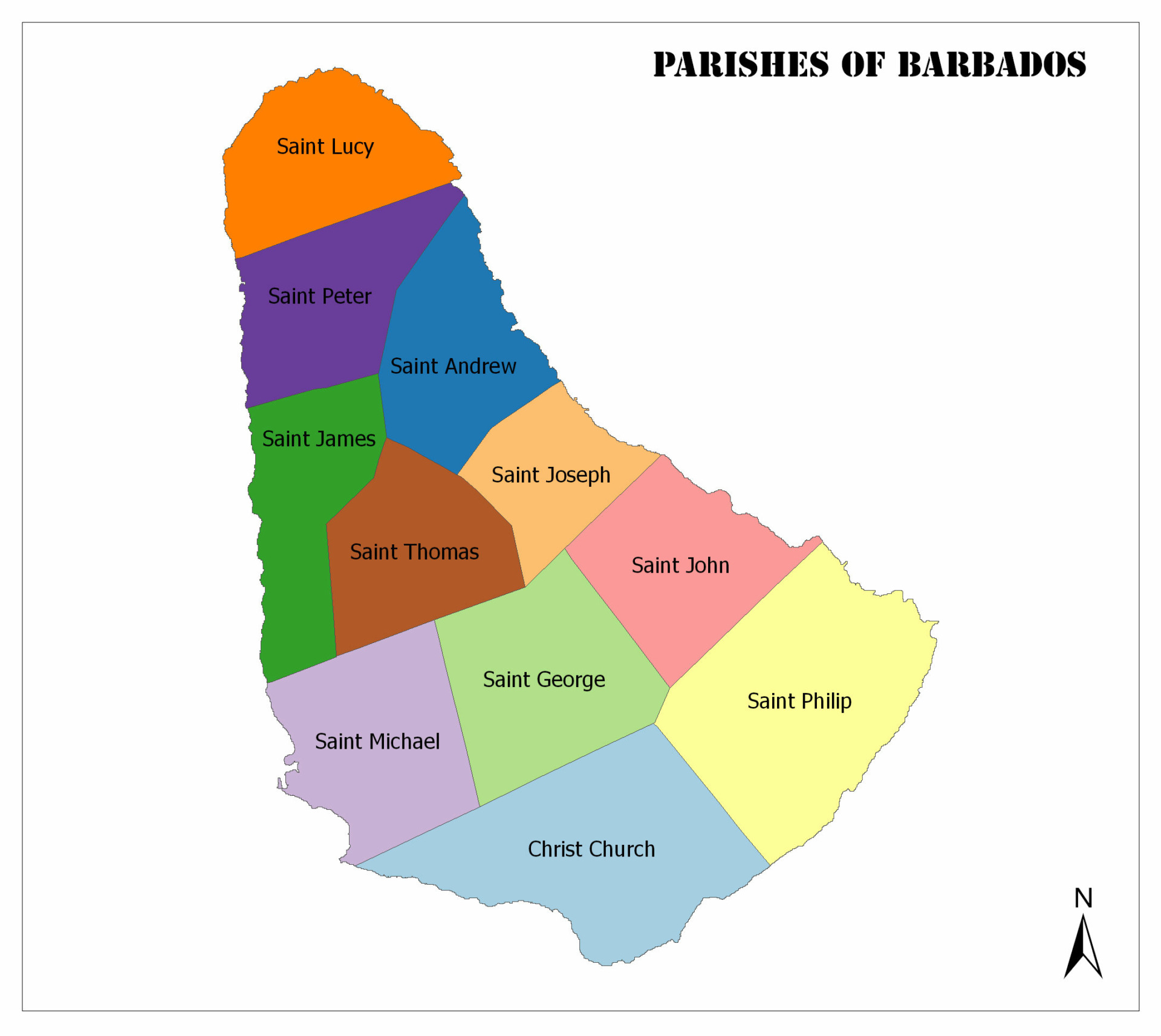
There are a total of 11 parishes in Barbados.

In this article, we will get some general information about the population and area of the parishes of Barbados. You can see Barbados’ parishes on the map below:

Parishes of Barbados

A color map displays Barbados' parishes, each labeled by name, with a compass rose in the lower right corner.
Parishes of Barbados

Christ Church

A tropical beach scene with palm trees, white sand, and clear blue water under a partly cloudy sky. There are a few people and beach chairs visible.
Christ Church

Oistins is the capital. The population of 2010 is 54,336. It has an area of 57 square kilometers.

St. Andrew

A picturesque coastal scene featuring a green field, a winding road, a beach with waves, under a cloudy blue sky.
St. Andrew

Greenland is the capital. The population of 2010 is 5,139. It has an area of 36 square kilometers.

St. George

A scenic coastal landscape with turquoise waters, sandy beach, green foliage, and a clear sky.
Bulkeley

Bulkeley is the capital. The population of 2010 is 19,767. It has an area of 44 square kilometers.

St. James

Aerial view of a tropical beach with clear turquoise waters, a breakwater, several boats, and beachfront buildings surrounded by greenery.
Holetown

Holetown is the capital. The population of 2010 is 28,498. It has an area of 31 square kilometers.

St. John

A coastal landscape with a large rocky cliff overhanging turquoise ocean waves under a clear blue sky.
Four Roads

Four Roads is the capital. The population of 2010 is 8,963. It has an area of 34 square kilometers.

St. Joseph

A tropical beach scene with waves, rocks, palm trees, lush greenery, and a blue sky with clouds.
Bathsheba

Bathsheba is the capital. The population for 2010 is 6,620. It has an area of 26 square kilometers.

St. Lucy

Two people stand on a beach near the water, with a boat nearby, under a bright sky. A fence and greenery are in the foreground.
Crab Hill

Crab Hill is the capital. The population for 2010 is 9,758. It has an area of 36 square kilometers.

St. Michael

Aerial view of a tropical beachfront with buildings, palm trees, and people on the sand near the clear blue water.
Bridgetown

Bridgetown is the capital of St. Michael and it’s also the capital of Barbados. The population of 2010 is 88,529. It has an area of 39 square kilometers.

St. Peter

A serene tropical beach scene with a white railing, pink flowers, palm trees, power lines, and a distant boat.
Bridgetown

Speightstown is the capital. The population of 2010 is 11,300. It has an area of 34 square kilometers.

St. Philip

A tropical beach with white sand, turquoise water, palm trees, and a few beach chairs under the shade, with buildings on the coastline.
Bridgetown

Crane is the capital. The population of 2010 is 30,662. It has an area of 60 square kilometers.

St. Thomas

Aerial view of a tropical beach with a curved stone pier, clear blue waters, green hills in the background, and a few small boats on the shore.
St. Thomas

Hillaby is the capital. The population of 2010 is 14,249. It has an area of 34 square kilometers.