Located in the Southwestern United States, New Mexico is a state rich in diversity, from its stunning landscapes to its unique blend of cultural influences. Known as the Land of Enchantment, New Mexico offers vast desert expanses, striking mountain ranges, and historic pueblo communities.
The state’s Native American and Hispanic heritage is an integral part of its identity and is evident in its art, architecture, traditions, and cuisine.
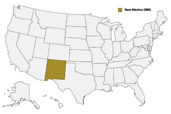
New Mexico (NM) on the US Map
New Mexico is divided into 33 counties, each with its own distinctive personality and allure. From the bustling streets of Bernalillo County’s Albuquerque to the tranquil beauty of Taos County’s high desert, this post will journey through New Mexico’s counties.
We’ll start with a detailed New Mexico Counties Map that shows the borders of each county as well as the state’s largest cities. Then we’ll take a closer look at the most interesting counties in New Mexico.
Map of New Mexico Counties
Below is a map of the 105 counties of New Mexico (you can click on the map to enlarge it and to see the major city in each county).
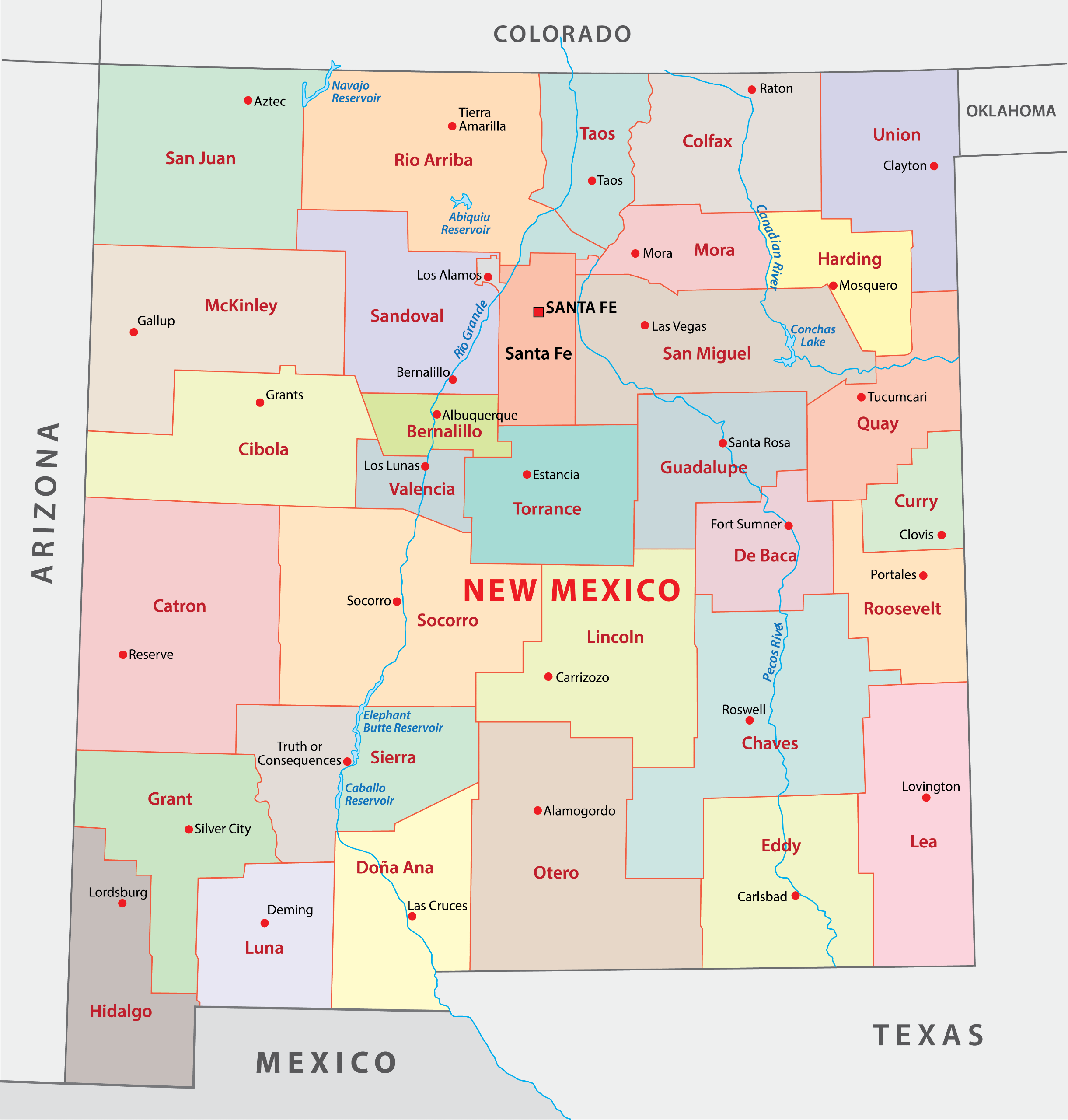
Interactive Map of New Mexico Counties
Click on any of the counties on the map to see its population, economic data, time zone, and zip code (the data will appear below the map). Data is sourced from the US Census 2021.
List of the Counties of New Mexico:
| County | Population | Per sq. km | Largest City |
|---|---|---|---|
| Bernalillo County | 674,919 | 224.4 | Albuquerque |
| Catron County | 3,581 | 0.2 | Reserve |
| Chaves County | 65,014 | 4.14 | Roswell |
| Cibola County | 27,284 | 2.32 | Grants |
| Colfax County | 12,406 | 1.27 | Raton |
| Curry County | 48,716 | 13.38 | Clovis |
| De Baca County | 1,873 | 0.31 | Fort Sumner |
| Doña Ana County | 218,157 | 22.12 | Las Cruces |
| Eddy County | 61,096 | 5.65 | Carlsbad |
| Grant County | 28,178 | 2.75 | Silver City |
| Guadalupe County | 4,465 | 0.57 | Santa Rosa |
| Harding County | 533 | 0.1 | Roy |
| Hidalgo County | 4,214 | 0.47 | Lordsburg |
| Lea County | 72,743 | 6.4 | Hobbs |
| Lincoln County | 20,084 | 1.61 | Ruidoso |
| Los Alamos County | 19,169 | 67.82 | Los Alamos |
| Luna County | 25,282 | 3.29 | Deming |
| McKinley County | 72,946 | 5.17 | Gallup |
| Mora County | 4,232 | 0.85 | Mora |
| Otero County | 67,298 | 3.93 | Alamogordo |
| Quay County | 8,675 | 1.17 | Tucumcari |
| Rio Arriba County | 40,347 | 2.66 | Española |
| Roosevelt County | 19,223 | 3.03 | Portales |
| San Juan County | 122,912 | 8.6 | Farmington |
| San Miguel County | 27,357 | 2.24 | Las Vegas |
| Sandoval County | 147,327 | 15.33 | Rio Rancho |
| Santa Fe County | 153,632 | 31.05 | Santa Fe |
| Sierra County | 11,512 | 1.06 | Truth or Consequences |
| Socorro County | 16,605 | 0.96 | Socorro |
| Taos County | 34,322 | 6.02 | Taos |
| Torrance County | 15,150 | 1.75 | Moriarty |
| Union County | 4,122 | 0.42 | Clayton |
| Valencia County | 75,992 | 27.5 | Los Lunas |
Biggest Counties in New Mexico by Population
Bernalillo County

Bernalillo County, established in 1852, is at the heart of New Mexico and is the most populous county in the state. Albuquerque, its largest city and county seat, is a vibrant urban center with a rich blend of cultures, history, and modern attractions. This county is known for hosting the Albuquerque International Balloon Fiesta, the world’s largest hot-air balloon festival, drawing visitors from around the globe.
The county’s cultural identity is further enriched by the presence of the University of New Mexico, contributing to its dynamic arts scene and educational excellence. Bernalillo County offers access to the Sandia Mountains, providing a stunning natural backdrop and a plethora of outdoor activities, from hiking and skiing to the Sandia Peak Tramway, offering breathtaking views.
Historically significant sites like the Petroglyph National Monument showcase ancient rock carvings, connecting visitors to the region’s indigenous roots.
Doña Ana County

Doña Ana County, one of New Mexico’s oldest counties, was created in 1852. Its county seat, Las Cruces, is the second-largest city in New Mexico and offers a blend of cultural richness, historical depth, and natural beauty. This county is notable for housing New Mexico State University (NMSU), a key institution that contributes significantly to education and research in the region.
The county’s landscape is marked by the Rio Grande, which flows through it, providing vital agricultural resources for the surrounding land. Additionally, the Organ Mountains-Desert Peaks National Monument stands as a majestic natural landmark, offering outdoor enthusiasts opportunities for hiking, rock climbing, and wildlife observation.
Doña Ana County is also home to the historic town of Mesilla, known for its well-preserved adobe architecture and as the site where the Gadsden Purchase was ratified in 1854. Mesilla’s town plaza, surrounded by boutiques, galleries, and restaurants, hosts various cultural events, blending Mexican and American traditions.
Santa Fe County

Santa Fe County, established in 1852, surrounds New Mexico’s capital, Santa Fe, the oldest capital city in the United States. Rich in cultural heritage and artistic vibrancy, Santa Fe is renowned for its Pueblo-style architecture, a testament to the city’s indigenous roots and Spanish colonial past.
The city is a hub for artists and writers, evident in the numerous galleries lining Canyon Road and the annual Santa Fe Indian Market, which attracts thousands of artists, collectors, and enthusiasts from around the globe.
The county is also known for its stunning natural landscapes, including the Sangre de Cristo Mountains, offering outdoor activities such as hiking, skiing, and mountain biking. Santa Fe’s historic sites, such as the Palace of the Governors and San Miguel Chapel, known as the oldest church in the United States, provide a window into the area’s rich history.
Sandoval County

Sandoval County, organized in 1903, spans from the northwest suburbs of Albuquerque to the diverse landscapes of the Jemez Mountains. Its county seat, Bernalillo, is a town with deep historical roots, positioned along the historic Camino Real.
The county is notable for the Kasha-Katuwe Tent Rocks National Monument, featuring cone-shaped rock formations that are a result of volcanic activity, offering unique hiking experiences.
Included within Sandoval County is a portion of the Valles Caldera National Preserve, a massive volcanic caldera that provides a haven for wildlife and outdoor recreation. The county also encompasses several Native American pueblos, including Jemez Pueblo, known for its beautiful red pottery and cultural festivals.
Sandoval County’s diverse geography includes parts of the Rio Grande, lush forested mountains, and desert landscapes, supporting a variety of outdoor activities. The Bandelier National Monument, although primarily in neighboring Los Alamos County, extends into Sandoval, offering ancient pueblo ruins set amidst dramatic canyon and mesa country.
Smallest Counties in New Mexico by Population
Harding County

Harding County, established in 1921, is New Mexico’s least populous county. Named after President Warren G. Harding, it is located in the northeastern part of the state, characterized by its vast open spaces and rolling grasslands. The county seat, Mosquero, is a small village that embodies the quiet, rural life of the area.
This county is predominantly agricultural, with ranching playing a significant role in the local economy. The landscape is marked by the Canadian River Canyon, offering scenic beauty and outdoor recreation opportunities, including hiking and wildlife viewing.
Harding County’s remote location contributes to its tranquil atmosphere and slow pace of life. The community here maintains a close-knit feel, with local events and gatherings reinforcing the bonds among residents.
De Baca County

De Baca County, created in 1917, is situated in eastern New Mexico and named after Ezequiel Cabeza De Baca, the state’s second governor.
The county seat, Fort Sumner, is steeped in Wild West history, most notably as the final resting place of the infamous outlaw Billy the Kid, who was shot and killed by Sheriff Pat Garrett in 1881. The Billy the Kid Museum and his gravesite are significant attractions, drawing visitors interested in the lore of the American frontier.
The county is also home to the Fort Sumner State Monument, which preserves the remnants of a military fort and the Bosque Redondo Memorial, a site that commemorates the tragic history of the Navajo Long Walk. This forced relocation and internment affected thousands of Navajo and Mescalero Apache people in the 1860s.
Catron County

Catron County, established in 1921, is New Mexico’s largest county by area but one of the least populous, embodying the vast, untamed beauty of the state’s wilderness. Named after Thomas B. Catron, a prominent lawyer and politician, it is located in the southwestern part of New Mexico, featuring a landscape dominated by the Gila National Forest and the Apache National Forest.
This county is a haven for outdoor enthusiasts, offering expansive areas for hiking, camping, and horseback riding. The Gila Wilderness, the first designated wilderness area in the United States, provides a rugged and pristine landscape for backcountry adventures.
Catron County is also known for the Gila Cliff Dwellings National Monument, where visitors can explore the ancient homes of the Mogollon people, nestled in cave alcoves high above the canyon floor.
Union County

Union County, located in the northeastern corner of New Mexico, was established on January 1, 1894. Named for the union of two territories, it encompasses the towns of Clayton, the county seat, and Des Moines, among others. This county is characterized by its expansive plains and is part of the region known as the High Plains, offering panoramic views and wide-open skies.
Union County is rich in history, with landmarks such as the Clayton Lake State Park, known for its dinosaur footprints preserved in the mudstone along the lake’s spillway. The park is a significant paleontological site and a popular destination for both education and recreation.
Additionally, the Capulin Volcano National Monument offers visitors a unique opportunity to hike an extinct cinder cone volcano, providing breathtaking views of the surrounding volcanic field and beyond.
Notable Counties in New Mexico
Taos County

The eponymous county seat of Taos County is renowned for its historic Taos Pueblo, an ancient Native American community with multi-storied adobe dwellings that have been continuously inhabited for over a thousand years. This UNESCO World Heritage Site represents a critical aspect of the area’s Native American heritage and is a focal point for visitors seeking to understand the region’s cultural depth.
The county is also a magnet for outdoor enthusiasts, artists, and those seeking spiritual renewal, drawn to the dramatic beauty of the Sangre de Cristo Mountains and the Rio Grande del Norte National Monument. The latter offers dramatic vistas, whitewater rapids, and hot springs along the Rio Grande Gorge. Taos Ski Valley, another key attraction, provides some of the most challenging ski terrains in the Southwest.
Taos County’s artistic legacy is further cemented by its thriving arts community, with numerous galleries, studios, and the annual Taos Pueblo Pow-Wow, a celebration of Native American culture through dance, music, and craftsmanship.
The town of Taos itself, with its historic plaza, adobe architecture, and the iconic San Francisco de Assisi Mission Church, photographed and painted by artists like Ansel Adams and Georgia O’Keeffe, underscores the county’s standing as a nexus of cultural and natural beauty.
Rio Arriba County

Rio Arriba County, situated in northern New Mexico, spans a diverse landscape that includes the southern reaches of the Rocky Mountains, the Carson National Forest, and the high desert. Its county seat, Tierra Amarilla, encapsulates the area’s rich history and cultural heritage, which is deeply influenced by its Native American and Spanish colonial past.
The county is renowned for its outdoor recreational opportunities, notably within the Carson National Forest, offering vast expanses for hiking, fishing, and camping. The Chama River, a key feature of the landscape, is popular for its excellent trout fishing and scenic beauty, particularly along the Cumbres & Toltec Scenic Railroad, which provides a historic steam train journey through the breathtaking wilderness.
Rio Arriba County is also home to several important cultural sites, including the Monastery of Christ in the Desert, an active Benedictine monastery set in a remote and serene location near Abiquiu. The area around Abiquiu was famously captured in the paintings of Georgia O’Keeffe, who drew inspiration from the unique landscapes and vibrant colors of the region.
This county’s blend of stunning natural environments, cultural richness, and historical significance makes it a captivating area of New Mexico, offering a glimpse into both the ancient heritage and natural splendor of the Southwest.
Lincoln County

Lincoln County, established in 1869, is steeped in Wild West history, notably as the epicenter of the Lincoln County War, which catapulted Billy the Kid to fame. Its county seat, Carrizozo, serves as a gateway to exploring the diverse landscapes and historical sites that define this region.
The county is also home to the historic town of Lincoln, where visitors can walk through the Lincoln Historic Site, with preserved buildings like the Lincoln County Courthouse, offering a glimpse into the turbulent times of the late 19th century.
Aside from its rich history, Lincoln County boasts natural attractions such as the Capitan Mountains and the Valley of Fires Recreation Area, known for its ancient lava flows.
The scenic beauty of Ruidoso, nestled in the Sierra Blanca mountain range, offers year-round outdoor activities, including skiing and horse racing, making Lincoln County a blend of historical intrigue and natural wonder.
Grant County

Grant County, formed in 1868, is located in southwestern New Mexico with Silver City as its county seat. Silver City stands out for its vibrant arts scene, historic downtown, and as the gateway to the Gila Wilderness, the nation’s first designated wilderness area. This county offers a unique blend of culture and nature, attracting artists, hikers, and history enthusiasts alike.
Silver City’s commitment to the arts is evident in its numerous galleries, studios, and the annual Silver City Blues Festival, which draws musicians and fans from across the country. Grant County’s combination of historical depth, natural beauty, and artistic vitality makes it a captivating destination in New Mexico.
More About Counties in New Mexico: FAQs
What is the most beautiful county in New Mexico?
The most beautiful county in New Mexico is often considered to be Taos County, with its stunning mountain scenery, historic Taos Pueblo, and the breathtaking Rio Grande Gorge.
Which county in New Mexico has the youngest population?
Bernalillo County, which includes the city of Albuquerque and the University of New Mexico, typically has a younger demographic compared to other counties in the state.
This is largely due to its educational institutions and urban opportunities that attract younger residents.
Which is the smallest county in New Mexico?
The smallest county in New Mexico by area is Los Alamos County, known for the Los Alamos National Laboratory and its significant role in the development of the atomic bomb during World War II.
What’s the most affordable county in New Mexico?
One of the most affordable counties in New Mexico is typically Roosevelt County. Its affordability is due to the lower cost of living, particularly in housing, when compared to the more populous counties in the state.
What’s the richest county in New Mexico?
Los Alamos County is often cited as the richest county in New Mexico due to its high median household income, which is significantly bolstered by the presence of the Los Alamos National Laboratory and its high concentration of professional and technical workers.
- Colorful Hot Air Balloons Floating Over a Scenic River Landscape — © Greg Meland/Shutterstock
- Sunset Glow on the Organ Mountains in Doña Ana County, New Mexico — © John I Catlett/Shutterstock
- San Miguel Mission Chapel in Santa Fe County: The Oldest Adobe Church with Snow Accents — © Edwin Verin/Shutterstock
- Kasha-Katuwe Tent Rocks National Monument in Sandoval County — © sumikophoto/Shutterstock
- United States Post Office Building in Mosquero, New Mexico, with Water Tower in the Background — © Vacaypicts/Wikimedia Commons
- Quiet Afternoon in a Small Town with Clear Skies and Empty Streets — © Ketiltrout/Wikimedia Commons
- Gila Cliff Dwellings National Monument in Catron County, New Mexico — © Traveller70/Shutterstock
- Entrance Sign to Capulin Volcano National Monument with Volcanic Landscape in the Background — © IrinaK/Shutterstock
- Traditional Adobe Architecture at Taos Pueblo in New Mexico under a Clear Blue Sky — © 123455543/Shutterstock
- Sunset Over the Vibrant Sandstone Formations at Ghost Ranch, Abiquiu, New Mexico — © a. v. ley/Shutterstock
- Visitors Walking on a Curved Pathway Through a Rugged Lava Landscape — © CrackerClips Stock Media/Shutterstock