Municipalities of Kosovo are located in the provinces of the country and form the sub-administrative division. The current municipal structures are administrative divisions of the Republic of Kosovo.
The administrative structure of Kosovo currently defines several levels for Kosovo, whose administrative situation is not monolithic.
The first one is the administrative structure of the Republic of Kosovo, which declared its unilateral independence as of February 2008. Another is the structure adopted by NATO’s administration in the region.
The third administrative structure is the administrative structure of the Republic of Serbia, which still assumes a claim on Kosovo within its territory.
Map of the Municipalities of Kosovo
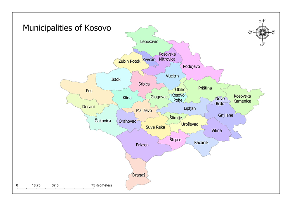
Thirty Municipalities of Kosovo
The United Nations Mission in Kosovo (UNMIK), the international administration established in Kosovo after the 1998-1999 Kosovo War, set new administrative boundaries with several additions, based on the administrative boundaries established for the former Autonomous Province of Kosovo and Metohija.
The administrative structure of the UNMIK and the administrative structure of the Republic of Kosovo coincide with the border. Kosovo is divided into thirty municipalities under seven districts.
Decani
Decani is one of the municipalities in Kosovo’s Gjakova District. The municipality has an area of 297 square kilometers. Decani’s population is 40,019 according to the 2011 census, with a population density of 130 / sq. Km. The municipality is also a mountainous region on the border between Montenegro and Albania. There are a total of 36 villages within the municipality.
Dragaš
The municipality of Dragaš is one of the municipalities in the Prizren District of Kosovo. The area of the municipality is 430 square kilometers. Dragaš’s population is 34,827 according to the 2011 census, with a population density of 81 / square kilometers.
There are a total of 36 villages within the municipality. Due to Dragaš’s poor agricultural resources and mountainous structure, the relative geographic isolation has led to Dragaš being one of the less developed Kosovo regions. The economic situation in Dragaš is fragile and unemployment is high.
Glogovac
The municipality of Glogovac is one of the municipalities in the Pristina District of Kosovo. The area of the municipality is 270 square kilometers. The population of Glogovac is 58,579 according to the 2011 census, with a population density of 212 square kilometers.
The municipality of Glogovac is located in central Kosovo. It is surrounded by Avca Mountains in the east and Dreniça hills in the north and west. The municipality includes 36 villages.
Glogovac has a religious Muslim identity. The Serbian cultural and religious structure in the region has never been. There are no Orthodox churches in Glogovac. In contrast, there are eight mosques. The largest mosque is in the center of Glogovac. All of these mosques are active.
Gnjilane
Gnjilane municipality is one of the municipalities in Kosovo’s Gjilan District. The area of the municipality is 392 square kilometers. The population of Gnjilane is 90,178 according to the 2011 census and the population density is 230 / square kilometers. Its location is close to Serbia and a bit further away from Macedonia. There are two main border gates with Serbia.
Ğakovica
Ğakovica municipality is one of the municipalities in Ğakovica District of Kosovo. The area of the municipality is 586 square kilometers. According to the 2011 census, the population of Ğakovica is 94,556 and the population density is 160 / square kilometers.
There are a total of 88 villages within the municipality.
Istok
The municipality of Istok is one of the municipalities in Peć District of Kosovo. The area of the municipality is 454 square kilometers. The population of Istok is 39,289 according to the 2011 census and its population density is 87 / square kilometers.
There are a total of 50 villages within the municipality. Istok is located in the nearest part of Kosovo to Serbia. The city shows this proximity with its cultural structure and demographic situation. The region of Istok is one of the most prominent areas of fish production and fishing in Kosovo.
Kacanik
Kacanik municipality is one of the municipalities in Ferizaj District of Kosovo. The area of the municipality is 211 square kilometers. The population of Kacanik is 33,409 according to the 2011 census and the population density is 150 / square kilometers.
There are a total of 31 villages within the municipality. Kacanik region is very suitable for winter and summer tourism. The land has many beautiful features. This location, where many beautiful views can be found, is also a station for buses. Kacanik is renowned for its production of building materials. However, the region is also in the foreground in terms of agriculture, farming, nursery and artisans.
Klina
The municipality of Klina is one of the municipalities in Kosovo’s Peć District. The area of the municipality is 309 square kilometers. According to the 2011 census, the population of Klina is 38,496 and the population density is 120 / square kilometers.
There are a total of 54 villages within the municipality. The most important fame of Klina is due to Mirusha Waterfalls. These waterfalls on Ak Drin are filled with many canyons and caves.
Kosovo Polje
Kosovo Polje is one of the municipalities in Kosovo’s Pristina District. The area of the municipality is 84 square kilometers. Kosovo Polje has a population of 34,827 according to the 2011 census, with a population density of 410 square kilometers.
There are a total of 16 villages within the municipality.
Kosovska Kamenica
Kosovska Kamenica municipality is one of the municipalities in Kosovo’s Gjilan District. The area of the municipality is 416 square kilometers. Kosovska Kamenica has a population of 36,085 according to the 2011 census, with a population density of 120 / square kilometers.
There are a total of 58 villages within the municipality.
Kosovska Mitrovica
Kosovska Mitrovica municipality is one of the municipalities in the Mitrovica District of Kosovo. The area of the municipality is 329 square kilometers. Kosovska Mitrovica has a population of 84,235 according to the 2011 census, with a population density of 256 / sq. Km.
There are 47 villages in the municipality. Kosovska Mitrovica, due to its proximity to Serbia and for political reasons, is a place where Kosovo Serbs and Serbian influence are visible.
Leposavic
The municipality of Leposavic is one of the municipalities in the Mitrovica District of Kosovo. The area of the municipality is 539 square kilometers. Leposavic’s population is 18,600 according to the 2015 census, with a population density of 35 / square kilometers.
There are a total of 75 villages within the municipality. Leposavic is in the region where the administrative structures of the Republic of Kosovo are not fully settled during the period of independence. This region is one of the main issues to be solved between Kosovo and Serbia.
Lipljan
The municipality of Lipljan is one of the municipalities in the Pristina District of Kosovo. The area of the municipality is 338 square kilometers. Lipljan’s population is 57,605 according to the 2011 census, with a population density of 170 / square kilometers.
There are 62 villages in the municipality. Located on a flat terrain, Liplan is located on the Pristina-Skopje highway.
Mališevo
The municipality of Mališevo is one of the municipalities in the Prizren District of Kosovo. The municipality has an area of 306 square kilometers. The population of Mališevo is 54,613 according to the 2011 census and the population density is 180 / square kilometers.
There are a total of 44 villages within the municipality. Mališevo is located in the western part of the fertile and famous Kosovo Plain.
Novo Brdo
The municipality of Novo Brdo is one of the municipalities in the Pristina District of Kosovo. The area of the municipality is 203 square kilometers. The population of Novo Brdo is 6,729 according to the 2011 census, with a population density of 47 / square kilometers.
There are a total of 26 villages within the municipality. The area of Novo Brdo has been well-known for its mountain forms and mines since history.
Obilic
The municipality of Obilic is one of the municipalities in the Pristina District of Kosovo. The area of the municipality is 104 square kilometers. The population of Obilic is 21,549 according to the 2011 census and the population density is 210 / square kilometers.
There are a total of 20 villages within the municipality. In the Obilic region, Kosovo has a large power plant. Due to this plant, which has existed since Yugoslavia period, a certain degree of pollution is observed in the air of the city and its surroundings.
Orahovac
Orahovac municipality is one of the municipalities in Kosovo’s Gjakova District. The municipality has an area of 275 square kilometers. The population of Orahovac is 56,208 according to the 2011 census and the population density is 200 / square kilometers.
There are a total of 36 villages within the municipality. Orahovac’s economy is agriculture-oriented. Vegetables and viticulture are particularly common here. The wine obtained from the grapes grown in the Orahovac vineyards has a reputation that extends beyond Kosovo.
Pec
The municipality of Pec is one of the municipalities in Kosovo’s Peć District. The area of the municipality is 602 square kilometers. Pec’s population is 96,450 according to the 2011 census, with a population density of 160 / square kilometers.
There are a total of 79 villages within the municipality. Located in the northwest of Kosovo. It is adjacent to the Sandžak region, one of the most densely populated areas of Serbia’s Muslim population.
Podujevo
The municipality of Podujevo is one of the municipalities in the Pristina District of Kosovo. The area of the municipality is 632 square kilometers. The population of Podujevo is 88,499 according to the 2011 census, with a population density of 140 / square kilometers.
There are a total of 77 villages within the municipality. The majority of the population of Poduyeva is Albanian. In the 1990s, the city had a population of up to 16% of Serbian and Montenegrin populations, but this rate declined over time, and today this figure is well below 1%.
Priština
The municipality of Priština is one of the municipalities in the Pristina District of Kosovo and is also the capital of Kosovo. The area of the municipality is 523 square kilometers. The population of Priština is 198,897 according to the 2011 census, with a population density of 380 / sq. Km.
There are a total of 43 villages within the municipality. It is located in the northeastern part of the republic, slightly east of the center of Kosovo. The municipality is located above the historic Kosovo Polje.
Prizren
The municipality of Prizren is one of the municipalities in the Prizren District of Kosovo. The area of the municipality is 626 square kilometers. The population of Priština is 177,781 according to the 2011 census, with a population density of 290 / square kilometers.
There are 76 villages in total. The city is located beneath the Šar Mountains. The municipality of Prizren is bounded by the states of Macedonia and Albania.
Srbica
The municipality of Srbica is one of the municipalities in the Mitrovica District of Kosovo. The area of the municipality is 374 square kilometers. Srbica’s population is 50,858 according to the 2011 census, with a population density of 140 / sq. Km.
There are a total of 49 villages within the municipality. The municipality, mostly Albanians, is the poorest in Kosovo and is where the last Kosovo war began in 1998. He suffered great losses in all respects at that time.
Štimlje
The municipality of Štimlje is one of the municipalities in the Ferizaj District of Kosovo. The area of the municipality is 134 square kilometers. The population of Štimlje is 27,324 according to the 2011 census and the population density is 200 / square kilometers.
There are 23 villages in the municipality. Štimlje is located at the junction of the Prizren-Skopje and Prizren-Pristina road routes in Kosovo.
Štrpce
The municipality of Štrpce is one of the municipalities in the Ferizaj District of Kosovo. The area of the municipality is 247 square kilometers. The population of Štrpce is 6,949 according to the 2011 census and the population density is 55 / square kilometers.
There are a total of 16 villages within the municipality. After the Kosovo War of 1998-1999, the population of the town increased with the Serbs who came here. According to the data, 66.7% of the people living in the city are Serbs.
Suva Reka
Suva Reka municipality is one of the municipalities in Prizren District of Kosovo. The area of the municipality is 361 square kilometers. According to the 2011 census, the population of Suva Reka is 59,722 and the population density is 170 / square kilometers.
There are a total of 41 villages within the municipality. Suva Reka city center is located in the south of Kosovo. The city feeds in many ways from the city of Prizren, just south of it. Prizren is Suva Reka’s trade source, cultural center, and social need.
Uroševac
The municipality of Uroševac is one of the municipalities in the Ferizaj District of Kosovo. The area of the municipality is 344 square kilometers. The population of Uroševac is 108,610 according to the 2011 census, with a population density of 310 square kilometers.
There are a total of 45 villages within the municipality. Uroševac is located in the southern part of Kosovo. The municipality is located at the intersection of Pristina-Skopje and Prizren-Skopje highway.
The US Camp Bondsteel Military Base, one of the world’s leading military bases, is located right next to this city. The establishment of the base began with the new process created after the 1999 NATO interventions.
Vitina
The municipality of Vitina is one of the municipalities in Kosovo’s Gjilan District. The area of the municipality is 269 square kilometers. The population of Vitina is 46,987 according to the 2011 census and the population density is 170 / square kilometers.
There are 39 villages in total.
Vucitrn
The municipality of Vucitrn is one of the municipalities in the Mitrovica District of Kosovo. The area of the municipality is 344 square kilometers. According to the 2011 census, the population of Vucitrn is 69,870 and the population density is 200 / square kilometers.
There are 67 villages in the municipality. The municipality is located in the northern part of Kosovo. It is close to Pristina.
Zubin Potok
Zubin Potok municipality is one of the municipalities in Mitrovica District of Kosovo. The area of the municipality is 334 square kilometers. The population of Zubin Potok is 6,616 according to the 2011 census and the population density is 45 / square kilometers.
There are 61 villages in total. Zubin Potok is located in the northern part of Kosovo. Gazivoda Lake, considered to be an important water source and water region for the whole of Kosovo, is located in the region.
Zvecan
The municipality of Zvecan is one of the municipalities in the Mitrovica District of Kosovo. The area of the municipality is 123 square kilometers. Zvecan’s population is 7,481 according to the 2011 census, with a population density of 140 / square kilometers.
There are a total of 35 villages within the municipality. Zvecan is located just north of Mitrovica. Zvecan is a region in Kosovo where Serbs are mostly populated.
Zveçan is located in the northern part of Kosovo where the administrative structures of the Republic of Kosovo cannot be fully established during the UN administration that occurred after the 1998-1999 Kosovo War and the independence declared on 17 February 2008.
Zvecan, together with Leposavic, Zubin Potok and the northern part of Mitrovica, is governed not by the administration of the Republic of Kosovo but by the administration of Serbia.