Montana, known as the “Treasure State,” is located in the Western United States and is famous for its stunning landscapes — sprawling forests, majestic mountains, and expansive plains can all be found here.
The state’s history is firmly rooted in the cultures of Native American tribes and the Old West, making it a destination for history lovers. It’s also home to untouched nature in places like Glacier National Park as well as urban settings in cities like Billings and Bozeman.
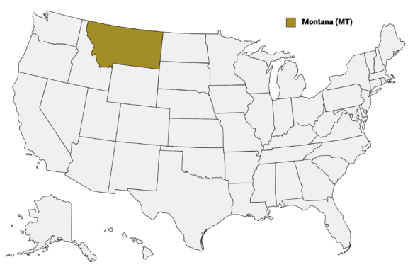
Montana (MT) on the US Map
Montana is divided into 56 counties, each with its own unique character and resources. Whether it’s mineral-rich Silver Bow County or the agricultural lands in Yellowstone County, these administrative divisions play a crucial role in local governance and community development.
In this post, we’ll provide an in-depth look at the Montana Counties Map, offering valuable insights into the distinct features of some of the state’s most notable counties.
Map of Montana Counties
Below is a map of the 56 counties of Montana (you can click on the map to enlarge it and to see the major city in each county).
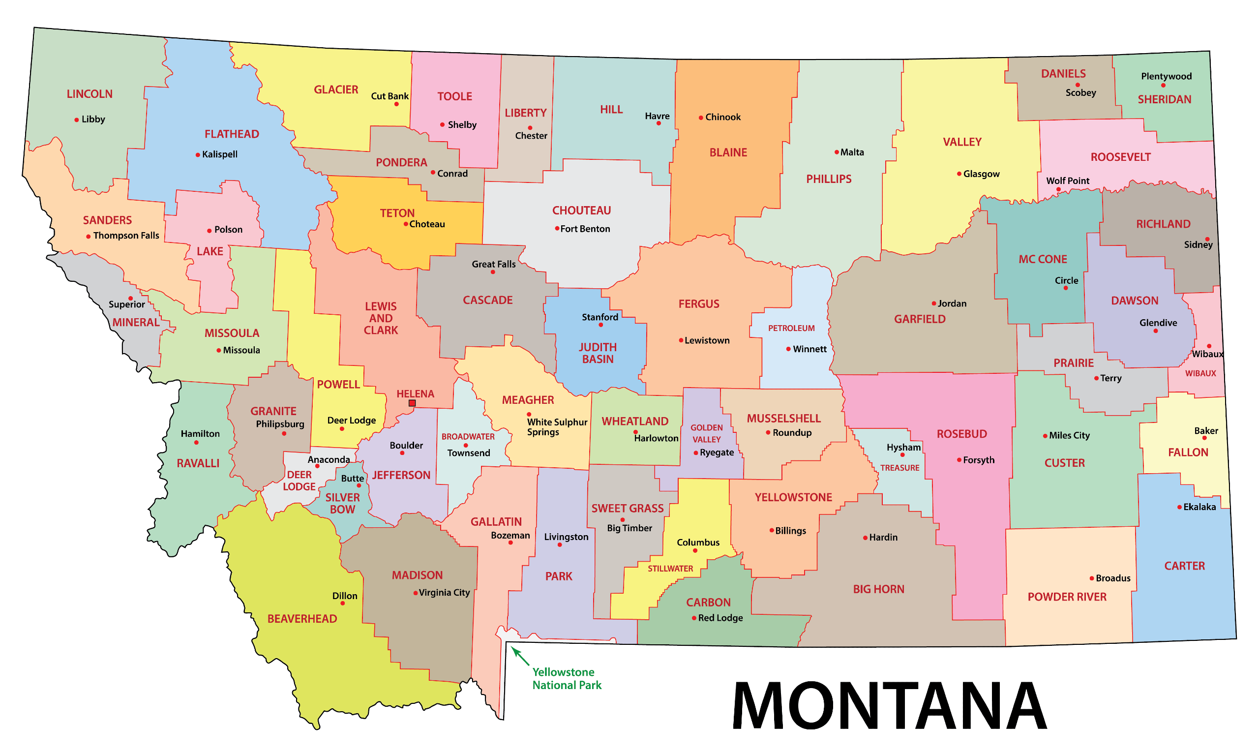
Interactive Map of Montana Counties
Click on any of the counties on the map to see its population, economic data, time zone, and zip code (the data will appear below the map). Data is sourced from the US Census 2021.
List of the Counties of Montana:
| County | Population | Per sq. km | Largest City |
|---|---|---|---|
| Beaverhead County | 9,391 | 0.65 | Dillon |
| Big Horn County | 13,198 | 1.02 | Hardin |
| Blaine County | 7,051 | 0.64 | Fort Belknap Agency |
| Broadwater County | 6,641 | 2.15 | Townsend |
| Carbon County | 10,488 | 1.98 | Red Lodge |
| Carter County | 1,349 | 0.16 | Ekalaka |
| Cascade County | 84,178 | 12.05 | Great Falls |
| Chouteau County | 5,896 | 0.57 | Fort Benton |
| Custer County | 11,968 | 1.22 | Miles City |
| Daniels County | 1,739 | 0.47 | Scobey |
| Dawson County | 9,003 | 1.47 | Glendive |
| Deer Lodge County | 9,380 | 4.92 | Anaconda |
| Fallon County | 3,074 | 0.73 | Baker |
| Fergus County | 11,464 | 1.02 | Lewistown |
| Flathead County | 103,400 | 7.85 | Kalispell |
| Gallatin County | 116,725 | 17.3 | Bozeman |
| Garfield County | 972 | 0.08 | Jordan |
| Glacier County | 13,827 | 1.78 | North Browning |
| Golden Valley County | 820 | 0.27 | Ryegate |
| Granite County | 3,333 | 0.75 | Philipsburg |
| Hill County | 16,297 | 2.17 | Havre |
| Jefferson County | 12,057 | 2.81 | Montana City |
| Judith Basin County | 2,004 | 0.41 | Stanford |
| Lake County | 31,030 | 8.04 | Polson |
| Lewis and Clark County | 70,340 | 7.85 | Helena |
| Liberty County | 2,026 | 0.55 | Chester |
| Lincoln County | 19,674 | 2.1 | Libby |
| Madison County | 8,499 | 0.91 | Big Sky |
| McCone County | 1,805 | 0.26 | Circle |
| Meagher County | 1,932 | 0.31 | White Sulphur Springs |
| Mineral County | 4,490 | 1.42 | Superior |
| Missoula County | 117,379 | 17.48 | Missoula |
| Musselshell County | 4,813 | 0.99 | Roundup |
| Park County | 17,072 | 2.35 | Livingston |
| Petroleum County | 434 | 0.1 | Winnett |
| Phillips County | 4,233 | 0.32 | Malta |
| Pondera County | 5,974 | 1.42 | Conrad |
| Powder River County | 1,759 | 0.21 | Broadus |
| Powell County | 6,955 | 1.15 | Deer Lodge |
| Prairie County | 1,227 | 0.27 | Terry |
| Ravalli County | 43,790 | 7.07 | Hamilton |
| Richland County | 11,375 | 2.11 | Sidney |
| Roosevelt County | 10,884 | 1.78 | Wolf Point |
| Rosebud County | 8,464 | 0.65 | Lame Deer |
| Sanders County | 12,298 | 1.72 | Thompson Falls |
| Sheridan County | 3,522 | 0.81 | Plentywood |
| Silver Bow County | 35,017 | 18.83 | Butte |
| Stillwater County | 8,916 | 1.92 | Columbus |
| Sweet Grass County | 3,690 | 0.77 | Big Timber |
| Teton County | 6,173 | 1.05 | Choteau |
| Toole County | 5,013 | 1.01 | Shelby |
| Treasure County | 693 | 0.27 | Hysham |
| Valley County | 7,553 | 0.59 | Glasgow |
| Wheatland County | 2,082 | 0.57 | Harlowton |
| Wibaux County | 1,018 | 0.44 | Wibaux |
| Yellowstone County | 163,593 | 23.98 | Billings |
Biggest Counties in Montana by Population
Yellowstone County

Yellowstone County, situated in the south-central region of Montana, is the most populous county in the state. It’s named after the famous Yellowstone River, which flows through the area and also lends its name to the nearby Yellowstone National Park.
The largest city in Yellowstone County and Montana is Billings, which is also the county seat. Billings is an economic hub in Montana, acting as a trade and distribution center for the state. The city is also known for providing easy access to hiking opportunities as well as its annual Magic City Blues festival.
The history of Yellowstone County is closely related to that of Native American tribes like the Crow and Northern Cheyenne, as well as the impact of the railroad and frontier expansion. Part of the Crow Indian Reservation is located in the county.
Montana State University is also located in Billings, which adds to the city’s atmosphere and encourages community growth.
Missoula County

Another of the most populous counties in Montana is Missoula County, located in the western part of the state. The county is perhaps best known for its namesake, the city of Missoula, which serves as both the county seat and the home of the University of Montana.
Nestled amidst the natural grandeur of the Rocky Mountains, the county is a magnet for outdoor enthusiasts. The many outdoor activities available include hiking in the Rattlesnake National Recreation Area and floating down the Clark Fork River; there are things to do outside at all times of the year.
Culturally, Missoula County benefits from the presence of the University of Montana, which contributes a youthful energy to the region and brings a variety of cultural events, from music festivals to art exhibitions.
This intellectual atmosphere pairs well with the county’s rich history, influenced by both Native American tribes like the Salish and Kootenai, and the lumber and railroad industries that helped shape the West.
Gallatin County

Gallatin County is situated in southwestern Montana and is one of the state’s fastest-growing regions. Bozeman, the county seat, is known for its high quality of life, driven by a robust economy, excellent educational facilities, and abundant recreational opportunities.
Home to Montana State University, Bozeman infuses the county with youthful energy, innovation, and a plethora of cultural activities, from art galleries to theaters. It is the second-most populous city in the state.
Outside of Bozeman, Gallatin County provides access to excellent outdoor activities, such as world-class skiing destinations like Big Sky Resort and Bridger Bowl. Fly-fishing and whitewater rafting are possible at the Gallatin River, a tributary of the Missouri River. The county also acts as a gateway to Yellowstone National Park.
The history of humans in the county’s territory dates back thousands of years, and the tribes that inhabited the land several hundreds of years ago include the Shoshone, Nez Perce, Blackfeet, Flathead, and Sioux. European settlers arrived as early as the late 1700s, and the county was established in 1865.
Flathead County

Flathead County is located in northwestern Montana and shares its northern border with the US-Canada border. The county seat and largest city is Kalispell, whose name comes from the Salish language and means, ‘the flat land above the lake.” The city is known for its commercial and industrial activity.
One of the main features of the county is Flathead Lake, the largest natural freshwater lake in the Western United States. Also one of the cleanest lakes in the world, there are 141 campsites in the state park surrounding the lake. Offering chances for swimming, fishing, camping, and more, the lake is a key resource for both tourism and local recreation.
The county is also adjacent to Glacier National Park, a major destination for tourists seeking outdoor activities such as hiking, camping, and wildlife observation. Because of its proximity to natural attractions, the county’s economy benefits from a strong tourism industry — the population grows by about 40% during the months of June through August.
Flathead County is divided into three incorporated cities and several unincorporated communities, each with its own local administration. The county plays a role in providing essential services like law enforcement, public education, and healthcare.
Cascade County

Cascade County is located in central Montana, and its county seat is Great Falls. The city is named for the series of five waterfalls along the Missouri River, which played a significant role in the Lewis and Clark Expedition. Great Falls serves as an economic and cultural hub, hosting Malmstrom Air Force Base and institutions like the University of Providence.
The county is known for its diversified economy which includes healthcare, education, agriculture, and manufacturing. Agriculturally, the region produces wheat, barley, and cattle, among other products. Moreover, Great Falls has a strong manufacturing sector, including energy production and food processing.
In terms of natural attractions, the county offers several recreational areas, such as Giant Springs State Park, which has one of the largest freshwater springs in the U.S. The Missouri River also provides opportunities for fishing, boating, and other water activities.
Smallest Counties in Montana by Population
Petroleum County

Located in central Montana, Petroleum County is not only the least populous county in Montana but one of the least populous in the country. Established in 1925, Petroleum County’s name reflects the presence of petroleum and natural gas reserves in the area, although agriculture remains a more dominant sector.
The county is largely made up of public lands, including portions of the Helena-Lewis and Clark National Forest and the Charles M. Russell National Wildlife Refuge. These areas offer opportunities for hunting, fishing, and hiking.
Before the arrival of settlers of European descent, the area of Petroleum County was inhabited by Native American tribes such as the Crow, Blackfoot, Nez Perce, and Sioux. The county seat, Winnett, is named after Walter John Winnett, who had previously been captured and then adopted by the Sioux tribe.
The local government in Petroleum County manages a range of services, from public safety to education. Despite its low population, the county maintains its own school system and law enforcement agencies.
Treasure County

The second-least populous county in Montana is Treasure County, which can be found in the eastern part of the state and is predominantly characterized by its rural and agricultural landscape. The main economic activities in the county are farming and ranching, though the county also has some oil and natural gas operations.
The town of Hysham is the county seat and the only incorporated town in the county. Hysham was formerly part of Custer County until the establishment of Treasure County in 1919.
Like many areas in Montana, Treasure County offers outdoor recreational opportunities despite its small size. The Yellowstone River flows through the county, providing a venue for fishing, boating, and other water-related activities.
Some local attractions in Hysham, Montana, also grant visitors a glimpse into the region’s history. These include the Yucca Theater, constructed in 1931 and now used as a community theater, and the Treasure County 89’ers Museum.
Golden Valley County

As is the case with Montana’s other sparsely populated counties, Golden Valley County’s landscape is largely rural and the main sectors of its economy, livestock and grain farming, are agricultural. The county is situated in the central part of Montana, and the county seat is Ryegate.
The town of Ryegate is located on the northern bank of the Musselshell River, which flows through Golden Valley County. This river offers locals and visitors opportunities for fishing and other outdoor recreation activities. There are no major, large-scale tourist attractions in this county, a fact that contributes to its rural charm.
Originally part of the Sims-Garfield ranch, Ryegate is named after the rye field on the ranch. The town is also the location where the Nez Perce crossed the Musselshell River in their 1877 attempt to reach Canada from their homelands in Idaho.
Garfield County

Located in northeastern Montana, Garfield County also ranks among Montana’s least populous counties. The area of the county is primarily rural and the town of Jordan is its county seat and one of the few population centers in the region.
The town of Jordan was originally settled in 1896 by Arthur Jordan, a hunter who had brought his family to the location after hunting a great deal of game in the area. He was later the first Postmaster of the town’s Post Office. Garfield was established as a county in 1919.
The local economy in Garfield County is largely agricultural, with ranching and farming being the predominant industries. Beef cattle ranching is a significant activity, as well as the cultivation of crops like wheat and barley.
The Missouri River also flows through parts of Garfield County, offering recreational opportunities such as fishing and boating.
Notable Montana Counties
Lewis and Clark County

Lewis and Clark County is centrally located in Montana, with Helena as its county seat. Helena is not just the administrative center of the county, but also the state capital of Montana, making it a hub for government and political activities.
The county itself was named in honor of the famed Lewis and Clark Expedition, which passed through the area in 1805. The legacy of this historic journey is preserved in several landmarks and museums within the county, including the Gates of the Mountains Wilderness.
Economically, the county is diverse, with industries ranging from healthcare and education to government services. Helena is home to Carroll College and Helena College University of Montana, which contribute to the local economy and culture.
Outdoor enthusiasts can also take advantage of the county’s access to natural attractions like the Helena-Lewis and Clark National Forest for hiking, fishing, and camping.
Silver Bow County

Silver Bow County is located in southwestern Montana, with Butte serving as the county seat. Butte was once considered the “Richest Hill on Earth” because of its abundant mineral resources, including copper, silver, and gold.
The extensive mining activity in the area contributed significantly to the industrialization of the United States in the late 19th and early 20th centuries. This mining history is evident in landmarks such as the Berkeley Pit, a former open-pit copper mine that is now a Superfund site undergoing environmental remediation.
Today, Butte is a city with a rich cultural heritage, influenced by the diverse immigrant communities that came to work in the mines. It’s also home to Montana Tech, a university specializing in engineering and applied sciences, which contributes to both the local economy and the educational landscape.
More About Montana Counties: FAQs
What is the largest county in Montana by land area?
Beaverhead County is the largest county in Montana by land area, covering approximately 5,572 square miles (14,431 km2).
Is Montana mostly rural or urban?
Montana is predominantly rural. Even its largest cities like Billings, Missoula, and Bozeman have relatively small populations compared to major cities in other states.
What is the smallest county in Montana by land area?
The smallest county by land area is Silver Bow County, with an area of about 718 square miles (1,860 km2).
What were the nine original Montana counties?
The nine original counties created in 1865 were Beaverhead, Chouteau, Custer, Deer Lodge, Gallatin, Jefferson, Lewis And Clark, Madison, and Missoula Counties.
Are there Native American Reservations in Montana counties?
Yes, Montana is home to several Native American Reservations, such as the Flathead Indian Reservation in Lake County and the Blackfeet Indian Reservation in Glacier County.

- Scenic View of a Winding Road Through the Rugged Landscape Near Billings, Montana — © DCBoutte Photography/Shutterstock
- Scenic Trail Overlooking Missoula Valley and Mount Sentinel in Montana — © Jon Bilous/Shutterstock
- Ice Climber Ascending a Frozen Waterfall in a Snowy Mountain Landscape — © Zachj6497/Shutterstock
- Aerial View of Serene Lake with Islands and Distant Mountains — © Francisco Blanco/Shutterstock
- Canada Geese Wading in the Shallow Waters Above a Rocky Cascade at Giant Springs — © Nikki Yancey/Shutterstock
- Abandoned Farmhouse Amidst Rolling Hills Under a Cloudy Sky — © Tracy Grazley/Shutterstock
- Yucca Theatre in Treasure County with Pueblo Revival Architecture Style — © Larry D. Moore/Wikimedia Commons
- Dramatic Supercell Thunderstorm Over Rural Landscape — © John D Sirlin/Shutterstock
- Exterior View of a Brick Building in Garfield County with Ramp Access — © J.B. Chandler/Wikimedia Commons
- Aerial View of Montana State Capitol in Helena with Scenic Landscape Background — © Mihai_Andritoiu/Shutterstock
- Sunset Over Mining Headframes with Wildflowers in Foreground — © JWCohen/Shutterstock