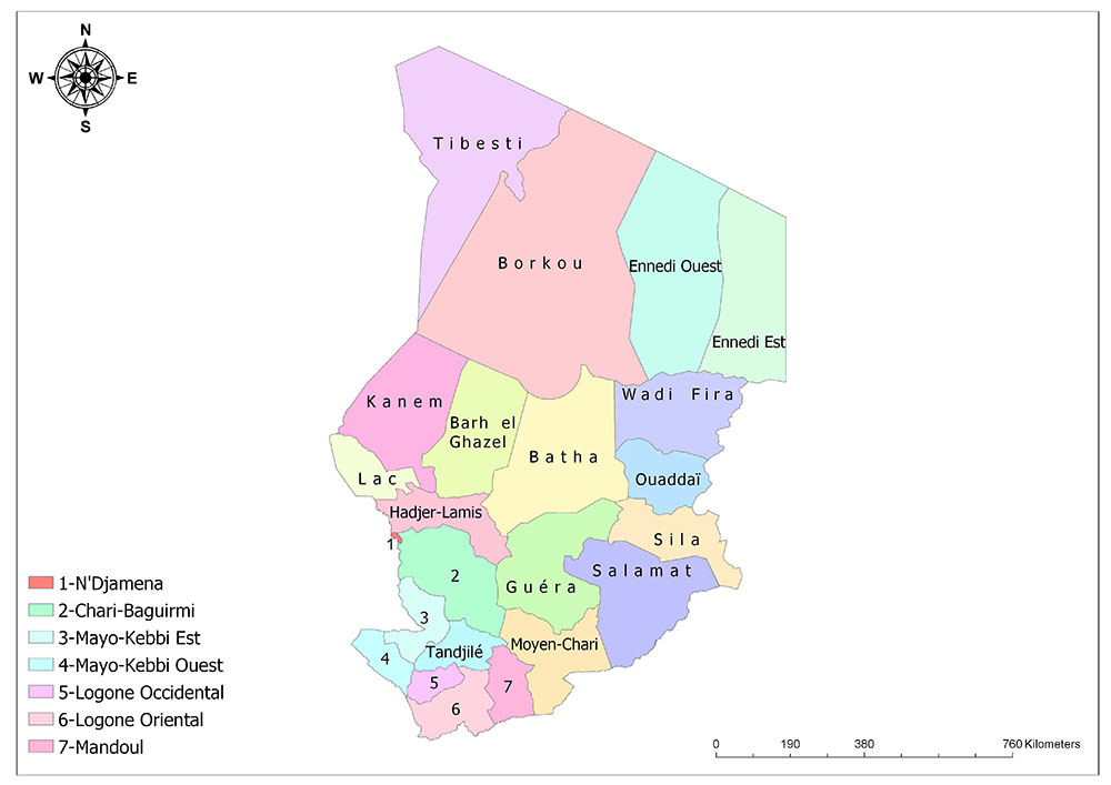
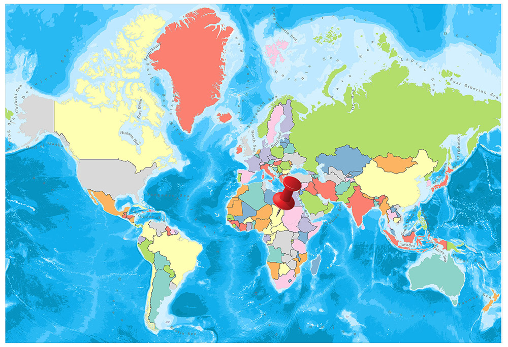
Chad is divided into 23 regions. In the last 2012, Borkou-Ennedi-Tibesti was divided into three regions. Then the Ennedi region is divided into two separate regions. All regions except N’Djamena are divided into two to four sub-regions. N’Djamena is divided into ten regions.

Twenty-Three Regions of Chad
Chad was divided into 14 regions from 1960 to 1999 when the country gained independence. By 1999, it was reorganized and this number was doubled and Chad was divided into 28 regions. In 2002, the number was reduced to 18 new regions. By 2008, this number was rearranged and four new regions were created. Thus, the number of regions was increased to 22. Finally, in 2012, Ennedi region was divided into two and the number of regions was increased to 23.
23 regions of Chad are Batha, Chari-Baguirmi, Hadjer-Lamis, Wadi Fira, Bahr al Gazel, Borkou, Ennedi-Est, Ennedi-Ouest, Guéra, Kanem, Lac, Logone Occidental, Logone Oriental, Mandoul, Mayo Kebbi Est, Mayo-Kebbi Ouest, Moyen-Chari, Ouaddaï, Salamat, Sila, Tandjilé, Tibesti, and N’Djamena.
Batha
The Batha Region is one of the 23 regions of Chad and is located in the central part of the country. The administrative center is Ati. The region is divided into three sub-provinces; Batha Est, Batha Ouest, Fitri. The population of 2009 is 527,031 people.
Chari-Baguirmi
Chari-Baguirmi Region is one of the 23 regions of Chad and is located in the southern part of the country. The administrative center is the city of Massenya. The region is divided into three sub-provinces; Baguirmi, Chari, Loug Chari. The population of 2009 is 621,785.
Hadjer-Lamis
The Hadjer-Lamis Region is one of the 23 regions of Chad and is located in the southwestern part of the country. The administrative center is Massakory city. The region is divided into three sub-provinces; Dababa, Dagana, Haraze Al Biar. The population of 2009 is 562,957.
Wadi Fira
The Wadi Fira Region is one of the 23 regions of Chad and is located in the southeastern part of the country. The administrative center is Biltine. The region is divided into three sub-provinces; Biltine, Dar Tama, Kobé. The population of 2009 is 508,383 people.
Bahr el Gazel
The Bahr al-Gazel region is one of the 23 regions of Chad and is located in the middle part of the country. The administrative center is Moussoro. The region is divided into two sub-regions; Barh El Gazel Nord, Barh El Gazel Sud. The population of 2009 is 260,865 people.
Borkou
The Borkou District is one of the 23 regions of Chad and occupies a very large area in the north of the country. The administration center is Faya-Largeau. The region is divided into two sub-regions; Borkou, Borkou Yala. The population of 2009 is 97,251.
Ennedi-Est
The Ennedi-Est Region is one of the 23 regions of Chad and is located in the northeastern part of the country. The administration center is Am-Djarass. The region is divided into two sub-regions; Am-Djarass, Wadi Hawar. The population of 2009 is 107,302. The Ennedi-Est region is one of the two newest areas in Chad, created in 2012.
Ennedi-Ouest
The Ennedi-Ouest Region is one of the 23 regions of Chad and is located in the northeastern part of the country. The administrative center is Fada city. The region is divided into two sub-regions; Fada, Mourtcha. The population of 2009 is 60,617. The Ennedi-Ouest region is one of the two newest regions in Chad, created in 2012.
Guéra
The Guéra Region is one of the 23 regions of Chad and is located in the southern part of the country. Its administrative center is in Mongo. The region is divided into four sub-provinces; Abtouyour, Barh Signaka, Guéra, Mangalmé. The population of the year 2009 is 553,795.
Kanem
Kanem Region is one of the 23 regions of Chad and is located in the middle part of the country. The administrative center is Mao. The region is divided into three sub-provinces; Kanem, Nord Kanem, Wadi Bissam. The population of 2009 is 354,603.
Lac
The Lac Region is one of the 23 regions of Chad and is located in the southwestern part of the country. The administrative center is the city of Bol. The region is divided into two sub-regions; Mamdi, Wayi. The population of 2009 is 451,369 people.
Logone Occidental
The Logone Occidental Region is one of the 23 regions of Chad and is located in the southern part of the country. The administrative center is Moundou city. The region is divided into four sub-provinces; Dodjé, Guéni, Lac Wey, Ngourkosso. The population of 2009 is 683,293.
Logone Oriental
The Logone Oriental Region is one of the 23 regions of Chad and is located in the southern part of the country. The management center is Doba city. The region is subdivided into six sub-provinces; La Nya, La Nya Pendé, La Pendé, Kouh-Est, Kouh-Ouest, Monts de Lam. The population of 2009 is 779,339 people.
Mandoul
The Mandoul Region is one of the 23 regions of Chad and is located in the southern part of the country. The administrative center is Koumra. The region is divided into three sub-provinces; Barh Sara, Mandoul Occidental, Mandoul Oriental. The population of 2009 is 628,065.
Mayo-Kebbi Est
The Mayo-Kebbi Est Region is one of the 23 regions of Chad and is located in the southwest of the country. The administrative center is Bongor. The region is divided into four sub-provinces; Kabbia, Mayo-Boneye, Mayo-Lémié, Mont d’Illi. The population of 2009 is 774,782 people.
Mayo-Kebbi Ouest
The Mayo-Kebbi Ouest Region is one of the 23 regions of Chad and is located in the southwestern part of the country. The administration center is Pala. The region is divided into two sub-regions; Lac Léré, Mayo-Dallah. The population of 2009 is 564,470.
Moyen-Chari
The Moyen-Chari Region is one of the 23 regions of Chad and is located in the southwestern part of the country. The administrative center is Sarh. The region is divided into three sub-provinces; Barh Kôh, Grande Sido, Lac Iro. The population of 2009 is 588,008.
Ouaddaï
Ouaddaï Region is one of the 23 regions of Chad and is located in the middle of the country. The administrative center is Abéché. The region is divided into three sub-provinces; Abdi, Assoungha, Ouara. The population of 2009 is 721,166 people.
Salamat
Salamat Region is one of the 23 districts of Chad and is located in the southeastern part of the country. Its administrative center is Am Timan. The region is divided into three sub-provinces; Aboudeia, Barh Azoum, Haraze-Mangueigne. The population of 2009 is 302,301.
Sila
The Sila Region is one of the 23 regions of Chad and is located in the southeastern part of the country. The administrative center is Goz Beïda. The region is divided into two sub-regions; Djourf Al Ahmar, Kimiti. The population of 2009 is 387,461.
Tandjilé
The Tandjilé Region is one of the 23 regions of Chad and is located in the southwestern part of the country. The management center is the city of Laï. The region is divided into two sub-regions; Tandjilly Est, Tandjilly Ouest. The population of the year 2009 is 661,906.
Tibesti
The Tibesti Region is one of the 23 regions of Chad and is located in the northwestern part of the country. The administrative center is Bardaï city. The region is divided into two sub-regions; Tibesti Est, Tibesti Ouest. The population of 2009 is 25,483. It became a region with the disintegration of the Borkou-Ennedi-Tibesti Region.
N’Djamena
N’Djamena is the capital and largest city of Chad with over 720,000 inhabitants. It is located where the Chari River meets the Logon River. It is divided into 10 administrative units called Arrondisment and has a special administrative status.
Facts About Chad
- Population: 15,642,001
- Population Density: 13 per Km2
- Land Area: 1,259,200 Km2
Chad is a landlocked land country located in Central Africa. Libya lies to the north, Niger to the west, Nigeria and Cameroon to the south, the Central African Republic to the south and Sudan to the east. Most of the country is covered by the Sahara Desert.

Geography
The center includes large dry plains, deserts in the north, mountains in the northwest and flats in the south. Petroleum, uranium, natron, kaolin, fish (Lake Chad) are the main natural resources. In the north, hot, dry, dusty winds are emerging. Periodic droughts and grasshopper invasions are other disasters. Today, the discovery of underground water resources in Africa, especially in Libya, Algeria, Egypt, Sudan, and Chad, has been explored.
Governance
Today, Chad is governed by the transitional constitution, which entered into force on 6 April 1993. The Constitution defines the regime in the country as a republican regime. However, the events that occurred in 1993 showed that the current administration avoided giving many opportunities. There is a 57-member legislature in the country.
The parliament, which consists of the governors and deputy governors of 14 provinces that make up the country, occasionally advises the administration.
The head of state is the head of state and the head of the government is the prime minister. Tribal heads and regional leaders have an impressive role in local governments. It is a member of international organizations such as UN, OIC (Organization of Islamic Conference), African Union, African Antilles, and Pacific Convention, IMF (International Monetary Fund) and the Islamic Development Bank.
Climate
A tropical climate is seen in the south and the desert climate is dominated by the presence of the Sahara Desert in the north. In the north, hot, dry, dusty winds occur. Because there are tropical forests with frequent trees in the south, these regions get plenty of rain. Grasslands and arable lands are more in this part.
The northern part consists mostly of deserts and mountainous areas. Chad, which has a climate varying according to the regions, has an average annual temperature of 25 degrees in Ndjamena, the capital of Chad, near the lake.
The average annual rainfall is 648 mm. In the city of Mundu, near the Cameroon borders, the average annual temperature is 23 degrees, and the average annual precipitation is 1228 mm. It continues from June to September.
Religion
There is no official religion of the state. However, more than 60% of the population is Muslim. 22% of those who believe in traditional natural religions. The remaining 18% are Christians. Muslims mostly live in the northern and central parts of the country, those who believe in traditional religions, or animists in the southern parts.
The majority of the Muslims are the Sunni Malik. The majority of Christians are Catholic, and a few are Protestants. Most of the Chad Christians were the Christians in the colonial period and in the following years. In addition, a small number of people from Europe came to settle in this country.
Industry and Tourism
Because of its geographical structure, lack of infrastructure, political conflicts, transportation problems and being completely surrounded by land, the country’s economy is very poor. The country in which hunger appears is one of the poorest countries in the world.
The main agricultural products of the country are cotton, rice, millet, and potatoes. 85 percent of the population live with agriculture and animal husbandry. Petroleum, uranium, natron, kaolin, fish (Lake Chad) are the main natural resources. Cotton, textile products and cattle are the main export products of the country. The main export partner is the USA with 78 percent.