Arizona is located in the far corner of the Southwest United States. Known for its natural beauty, Wild West history, and Native American heritage, there are 15 counties in Arizona. Each of these is unique, from the bustling cities of Maricopa County to the rural expanses of Greenlee County.
Read on to see a detailed Arizona Counties Map and to learn more about “The Grand Canyon State.”
Arizona (AZ) on the US Map

Arizona Counties Map
Below is a map of the 15 counties of Arizona (you can click on the map to enlarge it and to see the major city in each state).
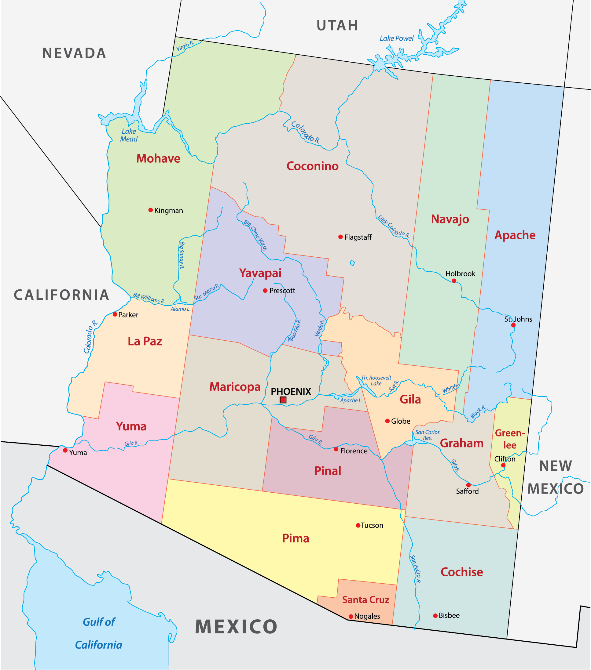
Interactive Arizona Counties Map
Click on any of the counties on the map to see the county’s population, economic data, time zone, and zip code (the data will appear below the map). Data is sourced from the US Census 2021.
List of the Counties of Arizona:
| County | Population | Per sq. km | Largest City |
|---|---|---|---|
| Apache County | 66,473 | 2.29 | Eagar |
| Cochise County | 125,092 | 7.78 | Sierra Vista |
| Coconino County | 144,942 | 3.01 | Flagstaff |
| Gila County | 53,211 | 4.32 | Payson |
| Graham County | 38,145 | 3.19 | Safford |
| Greenlee County | 9,542 | 2 | Clifton |
| La Paz County | 16,845 | 1.45 | Parker |
| Maricopa County | 4,367,186 | 183.24 | Phoenix |
| Mohave County | 211,274 | 6.12 | Lake Havasu City |
| Navajo County | 106,609 | 4.14 | Show Low |
| Pima County | 1,035,063 | 43.49 | Tucson |
| Pinal County | 420,625 | 30.26 | San Tan Valley |
| Santa Cruz County | 47,463 | 14.82 | Rio Rico |
| Yavapai County | 233,789 | 11.11 | Peoria |
| Yuma County | 202,944 | 14.21 | Yuma |
Apache County

Situated in the northeast corner of the state, Apache County is named after the indigenous Apache people and is the longest county in the nation. Two-thirds of the county’s population belongs to the Navajo Nation, and the county has the most land designated as an Indian reservation in the country.
Known for its diverse and beautiful landscapes, Apache County is the sixth-largest county by area in the US, spanning over 11,200 square miles. The county is home to parts of the Petrified Forest National Park, Monument Valley Tribal Park, and Wheatfields Lake, all of which offer great access to nature.
The largest town in Apache County is Eager, and the county seat is St. Johns. The county was founded in 1879.
Cochise County

Cochise County is located in the southeastern corner of Arizona and holds an important position in the history of the Wild West. Named after the legendary Apache chief, Cochise, the county is home to the city of Tombstone, the site of the infamous O.K. Corral shootout.
Another historically significant town in Cochise County is the picturesque town of Bisbee, known for its mining history and serving as the county seat since 1929.
In addition to historically interesting sites, there are several protected natural places in this county, such as Chiricahua National Monument, Kartchner Caverns State Park, and the Leslie Canyon National Wildlife Refuge.
Coconino County

Coconino County is the second-largest county by area in the contiguous United States. Its most famous feature is the Grand Canyon, one of the seven natural wonders of the world and one of the country’s top tourist attractions. Visitors can take advantage of a number of available guided tours and helicopter rides.
Nomadic hunters from the Great Plains made their way to the area of the Grand Canyon around 12,000 years ago, and the Havasupai have inhabited the land for at least 800 years. Other federally recognized nations living in Coconino County are Navajo, Hualapai, and Hopi.
The county seat and largest city in Coconino County is Flagstaff, Arizona, sometimes called the “City of Seven Wonders” for its easy access to national parks and monuments.
Gila County

Gila County is located near the center of Arizona and is home to several historical mining towns like Globe, which is the county seat, and Miami, where mining began in 1911. The county is also home to mountain towns to the north, such as Payson, Pine, Strawberry, and Rye.
The Tonto National Monument is one of the most fascinating locations in Gila County. There are cave dwellings carved into rocks here from more than 700 years ago that are part of the Salado Phenomenon. Visitors will also find plenty of options for fishing, camping, and hiking in and around the lakes and forests of Gila County.
Graham County

Situated in southeastern Arizona, Graham County is known for its natural beauty, small-town charm, and historic appeal. The county is named after Mount Graham, the county’s highest peak at 10,516 feet, and Safford is its county seat and largest city.
Notably, Mount Graham is home to the Large Binocular Telescope, one of the most powerful telescopes in the world. It is responsible for providing exceptionally sharp images of space and offers seasonal tours to visitors.
Outdoor activities abound in Arizona’s Graham County. Fishing and boating near Coolidge Dam and hiking in the Coronado National Forest are some of the most popular outdoor activities for visitors and locals alike.
Greenlee County

The least populous county in Arizona is Greenlee County, which borders New Mexico in eastern Arizona. The low population makes the county a great escape for those looking to escape the hustle of city life, and the county’s incredible natural beauty is largely undisturbed by human presence.
The Blue Range Primitive Area offers many opportunities for hiking, camping, and bird watching in unspoiled wilderness, and the Gila River is excellent for fishing and boating.
The county seat and largest town in Greenlee County is Clifton, which is located along the San Francisco River. One of the cultural events in Greenlee is the Greenlee County Fair, which takes place just outside the town of Duncan, Arizona.
La Paz County

La Paz County is the second-least populous county in the state of Arizona. Its name comes from an early settlement in the region that is now a ghost town and means “The Peace” in Spanish.
Located in western Arizona along the Colorado River, La Paz County is a region of stunning natural beauty and many outdoor activities.
The county seat, Parker, is home to the unique attraction of the Parker Dam, the world’s deepest dam. Another well known locale in La Paz County is the small town of Quartzsite, which is famed for its winter gem and mineral shows.
Maricopa County

The most populous county in Arizona and the fastest-growing county in the USA is Maricopa County. With the highest concentration of people in the state, Maricopa County is the economic and cultural heart of Arizona, offering a unique mix of urban energy and desert tranquility.
The capital of Arizona, Phoenix, is in Maricopa County, and the city’s top-class museums, vibrant food scene, and access to beautiful hiking trails make it a popular destination in the region. Golfers also flock to Phoenix for the more than 200 courses in the city and neighboring communities.
Maricopa County was founded in 1871, more than 40 years before Arizona gained statehood. In its early history, the economy was based on Arizona’s five C’s: cattle, citrus, climate, copper, and cotton.
Mohave County

Situated in the northwestern corner of Arizona, Mohave County is known for its stunning landscapes, vibrant history, and recreational opportunities. The county offers a segment of the awe-inspiring Grand Canyon and houses Lake Havasu City, celebrated for the relocated London Bridge.
The county is also home to a stretch of the historic Route 66, which was once one of the most popular highways in the USA and still features many landmarks on the National Register of Historic Places.
There are three Native American reservations in Mohave County, and they include the Fort Mojave, Kaibab, and Hualapai Indian reservations. The county seat is Kingman, and the largest city in the county is Lake Havasu City.
Navajo County

Situated in northern Arizona, Navajo County is notable for its natural beauty, Native American heritage, and historic charm. Driving through the county’s Petrified Forest National Park offers opportunities to enjoy scenic overlooks and hike short trails. Top-notch camping is possible in the Fool Hollow Recreation Area.
The Hopi Reservation is located in parts of Navajo County and Coconino County. Visitors to the reservation can learn about the history and traditions of the Hopi tribe, which has played a central role in the region’s history.
Holbrook is the Navajo County seat, and Show Low is the largest city. The small railroad town of Winslow, famed in the Eagles’ song “Take it Easy,” is now a tourist attraction in Navajo County.
Pima County

Pima County is located in South Arizona and is home to Tucson, the county seat and Arizona’s second-largest city. The county was created in 1864, is named after the Pima Native Americans, and hosts Saguaro National Park. It’s also where the Tohono O’odham Nation calls home.
Tucson is one of the best-known cities in Arizona for its energetic arts scene, historic architecture, diverse culinary options, and the University of Arizona. The city’s name is derived from the O’odham word Cuk Ṣon, which roughly means “at the base of the black hill.”
Pinal County

Founded in 1875, Pinal County is the third-most populous in Arizona and is located in the south-central part of the state. It’s home to portions of the Tohono O’odham Nation, the Gila River Indian Community, the San Carlos Apache Indian Reservation, and the Ak-Chin Indian Community.
Pinal County is also home to natural attractions like the Casa Grande Ruins National Monument and the Lost Dutchman State Park, both of which are major draws for tourism.
Located just south of Maricopa County, Pinal County is included in the Phoenix–Mesa–Scottsdale Metropolitan Statistical Area, and suburban growth from Greater Phoenix has begun to spread into the northern parts of the county. The county seat is Florence, Arizona, which is one of the oldest cities in the county.
Santa Cruz County

Nestled between Pima and Cochise counties in southern Arizona, Santa Cruz County is the smallest in the state and serves as a gateway to neighboring Mexico.
The county was established from parts of Pima County in 1899 and is named after the Santa Cruz River, which originates in the eastern part of the county and flows south into Mexico.
The county seat and largest city in the county is Nogales, which is located near the US-Mexico border. Visitors to Nogales can enjoy the Pimeria Alta Museum, which offers a journey through the region’s history.
Outside of its urban areas, Santa Cruz County is known for its beautiful landscape, including Patagonia Lake State Park, which includes a 265-acre lake and is a haven for bird watchers and outdoor enthusiasts.
Yavapai County

This county is named after the Yavapai people, whose name means “people of the sun” and who were the main inhabitants of the land when the United States annexed the area. It is the fourth-most populous county in Arizona and is located near the center of the state.
The county seat of Yavapai County is Prescott, Arizona. The city’s Wild West past is evident in landmarks like its downtown Courthouse Square and Whiskey Row, now home to many eateries and businesses. The World’s Oldest Rodeo is one of the most notable events that take place in Prescott each year.
The landscape in Yavapai County is also remarkable. Parts of Sedona, famed for its stunning red rock formations and unique terrain, fall within the county and provide land for hiking, biking, and even spiritual retreats.
Yuma County

Yuma County is located in the southwestern corner of Arizona and borders three states: California; Sonora, Mexico; and Baja California, Mexico. Its county seat and largest city is Yuma, which holds the Guinness World Record for most sunshine and is the winter residence of thousands of out-of-state visitors each year.
A defining feature of Yuma County is the Colorado River, which flows through the county and nurtures its rich agricultural sector, helping to earn it the title of “Winter Vegetable Capital of the World.” The river also provides opportunities for water sports, fishing, and bird-watching.
The Imperial Sand Dunes, one of the nation’s largest masses of inland sand dunes, are another attraction for outdoor enthusiasts. The thrill of off-road activities here attracts more than a million visitors annually.
More About Arizona Counties
Which is the largest county in Arizona by area?
Coconino County is the largest county in Arizona by area, and it’s also the second-largest in the United States. It covers a total area of 18,661 square miles (48,330 km2).
Which is the most populous county in Arizona?
Maricopa County is the most populous county in Arizona, housing the state capital, Phoenix. It is also the fourth most populous county in the United States.
What outdoor activities are available in Arizona counties?
Arizona counties offer a wide range of outdoor activities, including hiking, fishing, camping, boating, stargazing, and exploring historical sites. The Grand Canyon, Petrified Forest National Park, and Saguaro National Park are major attractions.
How diverse are the landscapes within Arizona counties?
Extremely diverse. The counties in Arizona showcase a range of landscapes, from desert to mountain ranges, forests, lakes, and rivers. You can find sprawling urban areas in Maricopa County and untouched natural beauty in Coconino and Greenlee counties.
How significant is Native American history in Arizona counties?
Native American history and heritage are deeply rooted in many of Arizona’s counties. Indigenous populations were present before the arrival of Europeans or the annexation of the land by the United States, and many Native American nations are still present and active.
Eight of Arizona’s 15 counties are named after Native American groups that are resident in present-day Arizona, and one is named after a Native leader.

- Sunlit Spider Rock Amidst the Verdant Canyon de Chelly Landscape — © Lucky-photographer/Shutterstock
- Historic Townscape of Bisbee, Arizona with Vintage Buildings and Rolling Hills — © Ingrid Curry/Shutterstock
- Sunrise at Toroweap Overlook with Views of the Colorado River in Grand Canyon National Park — © sumikophoto/Shutterstock
- Native American Cliff Dwellings at Tonto National Monument — © Zack Frank/Shutterstock
- Scenic View from Mount Graham Overlooking Vast Valleys and Mountain Ranges — © Patrick Lansing/Shutterstock
- Scenic View of a River Flowing Through a Mountainous Landscape with a Train Passing by in Clifton, Arizona — © Johnny Coate/Shutterstock
- View of Parker Dam on the Colorado River, Arizona — © Cheri Alguire/Shutterstock
- Golden Sunset Over Phoenix Skyline in Arizona — © f11photo/Shutterstock
- Colorful Hot Air Balloons Over London Bridge at Lake Havasu — © Angel McNall Photography/Shutterstock
- Vibrant Petrified Wood Amongst Badlands in Petrified Forest National Park — © Juan Carlos Munoz/Shutterstock
- Aerial View of a University Campus with Lush Greenery and Surrounding Urban Area — © Wangkun Jia/Shutterstock
- Sunset Glow on the Superstition Mountains Amidst the Cacti of the Sonoran Desert — © John D Sirlin/Shutterstock
- Santa Cruz County Courthouse in Nogales, Arizona, on a Cloudy Day — © Lindasj22/Shutterstock
- Sunset Reflections on Water in Sedona, Arizona — © arboursabroad.com/Shutterstock
- Sunrise Over the Tranquil Imperial Sand Dunes in Yuma County — © Larry Barrett/Shutterstock