Key Takeaways
- A magnitude 7.4 earthquake hit western Colombia. It struck at 7:34 am local time on 10 August 2026, with the epicenter about 5 km south of San José del Palmar in Chocó, according to the USGS.
- At least 294 people have died. Colombian authorities report at least 294 deaths, about 4,190 injured and 143 still missing as of 17 August. The quake destroyed more than 14,000 homes and damaged over 81,000, making it Colombia's deadliest earthquake since 1999.
- Felt across four countries. The shaking reached Bogotá, Cali and Medellín and was felt into Ecuador and Panama. No tsunami warning was issued, as the quake was inland.
- It was a deep earthquake. At about 110 km below the surface, this was an intermediate-depth quake inside the subducting Nazca plate. Deep quakes are felt over a much wider area but rupture less of the surface than shallow ones.
A powerful magnitude 7.4 earthquake struck western Colombia on the morning of 10 August 2026, killing at least 294 people and shaking a huge swathe of the country and its neighbours. The epicenter was in the department of Chocó, one of Colombia’s most remote and rain-soaked regions, but the tremor was powerful enough to rattle buildings hundreds of kilometres away in Bogotá.
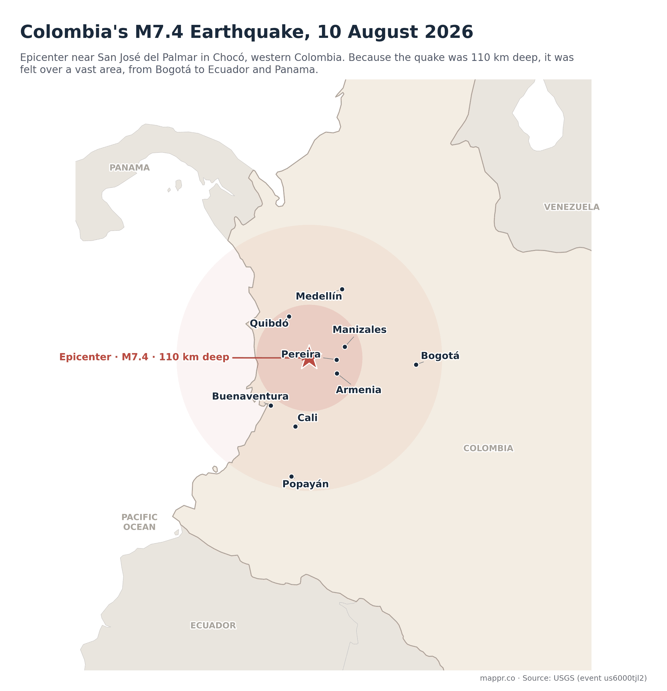
The epicenter sat about 5 kilometres south of San José del Palmar, close to the coffee-growing departments of Risaralda, Caldas and Quindío. Cities across the region, including Pereira, Manizales, Armenia, Cali and Medellín, reported strong shaking, damage and power cuts. Because Colombia’s Pacific coast is thinly populated, the largest cities sit inland, and it was there that most of the damage and casualties occurred.
Why a quake in Chocó was felt in four countries
The striking thing about this earthquake is how deep it was: around 110 kilometres below the surface, according to the USGS. That is not a shallow crustal quake but an intermediate-depth one, occurring inside the slab of the Nazca plate as it sinks beneath South America.
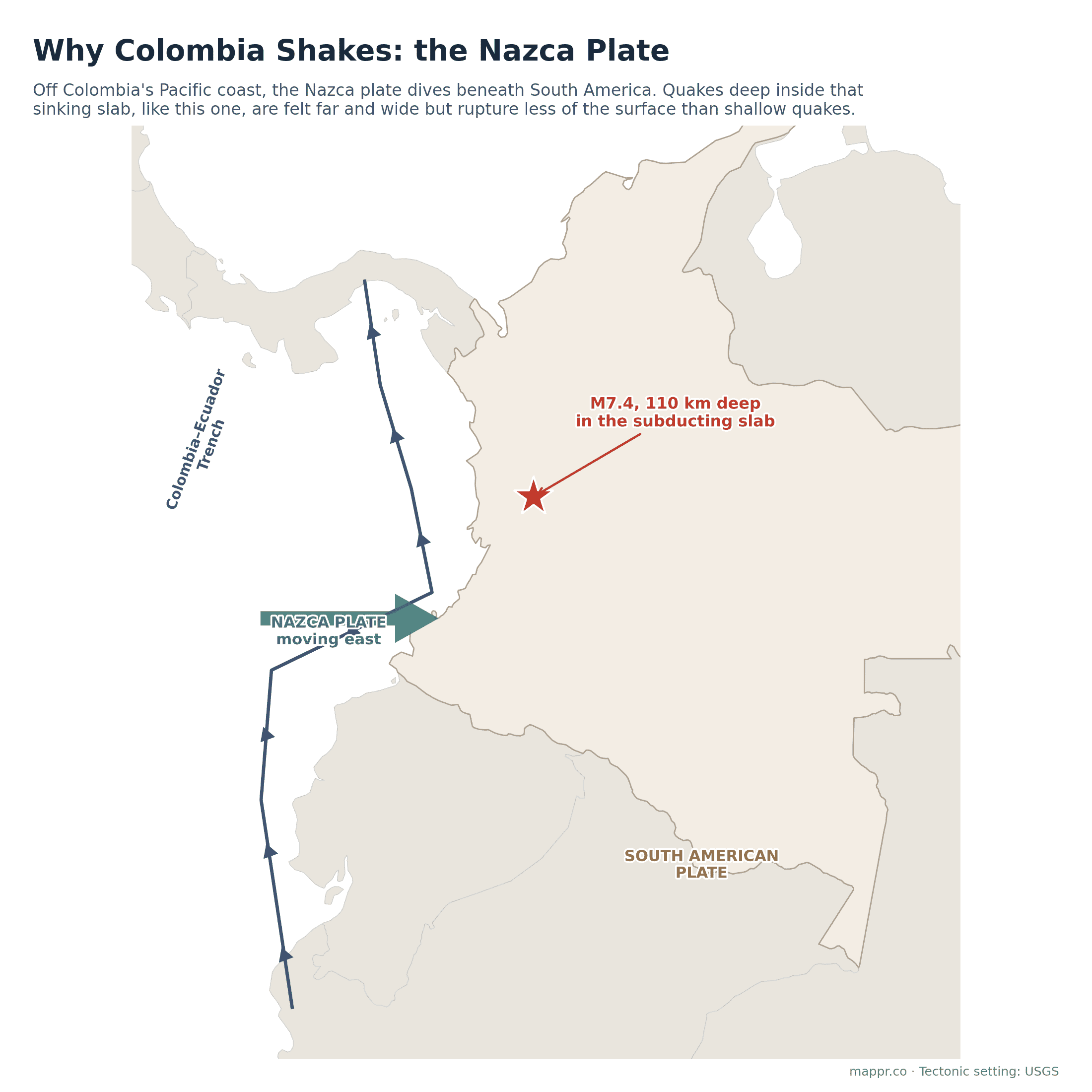
Off Colombia’s Pacific coast, the Nazca plate dives eastward beneath the South American plate along the Colombia-Ecuador trench. Earthquakes deep within that descending slab behave differently from shallow ones: their energy spreads out through a large volume of rock, so they are felt across enormous distances, in this case into Ecuador and Panama, but they tend to rupture less of the surface directly above. That depth is why millions of people felt the shaking, and also why a magnitude 7.4, which would be catastrophic at shallow depth, did not level entire cities.
What we know so far
This remains a developing story. The figures below are provisional and drawn from Colombian authorities and the USGS as of publication.
- 10 August, 7:34 am (local): A magnitude 7.4 earthquake strikes 5 km south of San José del Palmar, Chocó, at a depth of about 110 km (USGS). Strong shaking is felt across western and central Colombia, including Bogotá, Cali and Medellín.
- 10 August, morning: Reports of collapsed buildings and people trapped begin arriving from towns near the epicenter. Authorities activate emergency response and begin damage assessments.
- 10 August, evening: The national death toll is put at at least 111, with about 87 injured. No tsunami warning is issued. Shaking is confirmed to have reached Ecuador and Panama.
- 11 August: The scale becomes clearer as crews reach cut-off villages. The national death toll rises to at least 224, with more than 1,300 injured and over 2,700 people still missing. Colombia declares a national state of emergency, more than 100 aftershocks are recorded, and rescuers search collapsed buildings in Cali, Pereira, Quibdó and San José del Palmar. Around 1,600 buildings are reported damaged.
- 17 August: With most cut-off towns now reached, the confirmed toll stands at at least 294 dead, about 4,190 injured and 143 still missing (revised down from earlier estimates as people are accounted for). More than 14,000 homes are destroyed and over 81,000 damaged across 12 departments. It is confirmed as Colombia’s deadliest earthquake since 1999, and recovery in Chocó is slowed by landslide-blocked roads.
Colombia sits on one of the most seismically active margins on Earth, and large quakes here are not rare. For context on how this event ranks, see our map of the biggest earthquakes in the world. We will keep this page updated as the picture becomes clearer.